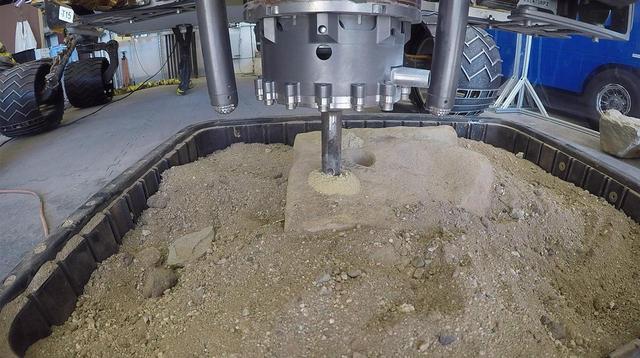
This video clip shows a test of a new percussive drilling technique at NASA's Jet Propulsion Laboratory in Pasadena, California. On May 19, NASA's Curiosity rover is scheduled to test percussive drilling on Mars for the first time since December 2016. The video clip was shot on March 28, 2018. It has been sped up by 50 times. Curiosity's drill was designed to pulverize rocks samples into powder, which can then be deposited into two chemistry laboratories carried inside of the rover. Curiosity's science team is eager to the rover using percussive drilling again; it will approach a clay-enriched area later this year that could shed new light on the history of water in Gale Crater. An animation is available at https://photojournal.jpl.nasa.gov/catalog/PIA22324
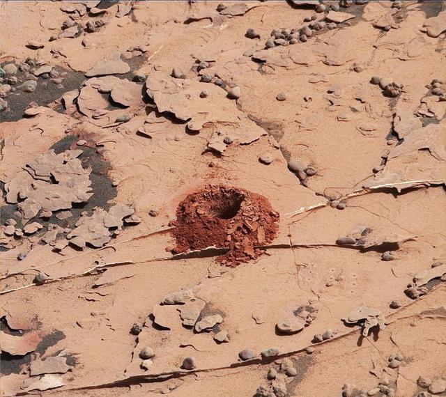
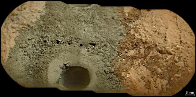
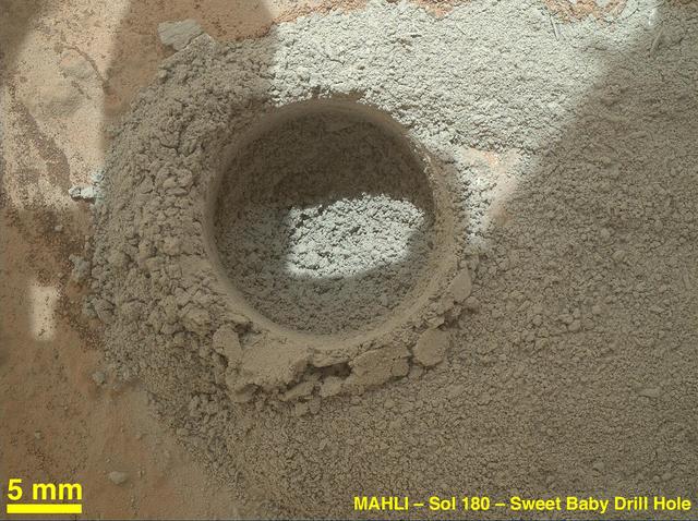
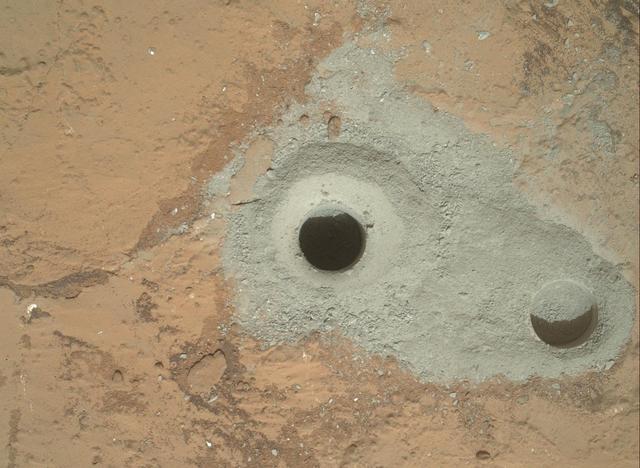
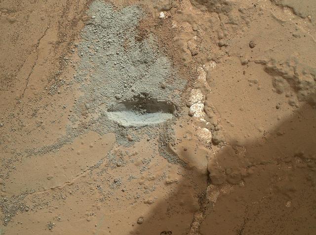
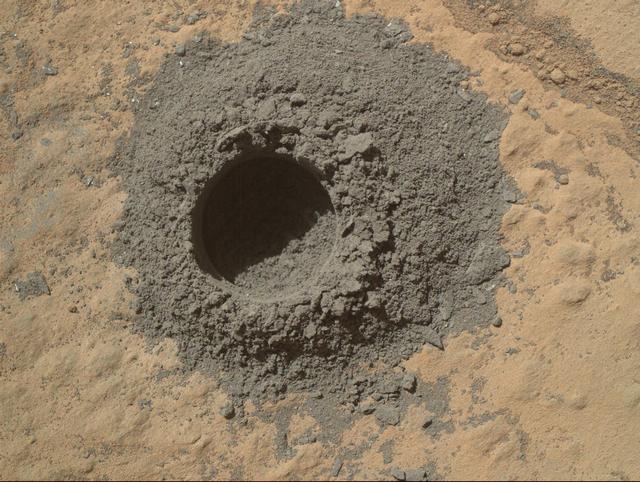
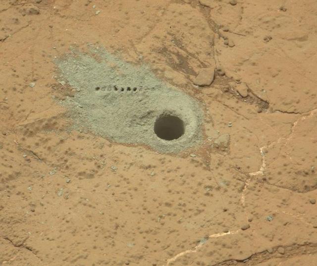
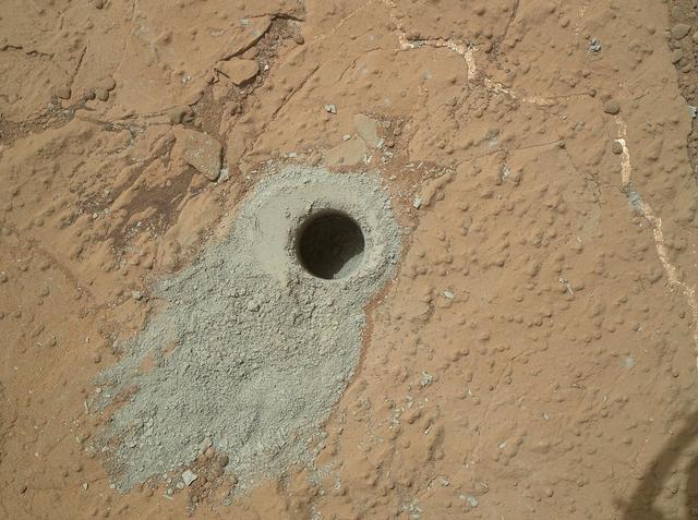
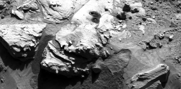
A close-up image of a 2-inch-deep hole produced using a new drilling technique for NASA's Curiosity rover. The hole is about 0.6 inches (1.6 centimeters) in diameter. This image was taken by Curiosity's Mast Camera (Mastcam) on Sol 2057. It has been white balanced and contrast-enhanced. Curiosity drilled this hole in a target called "Duluth" on May 20, 2018. It was the first rock sample captured by the drill since October 2016. A mechanical issue took the drill offline in December 2016. https://photojournal.jpl.nasa.gov/catalog/PIA22326
NASA's Curiosity rover successfully drilled a hole 2 inches (5.1 centimeters) deep in a target called "Duluth" on May 20, 2018. The hole is about .6 inches (1.6 centimeters) across. It was the first rock sample captured by the drill since October 2016. A mechanical issue took the drill offline in December 2016. Engineers at NASA's Jet Propulsion Laboratory in Pasadena, California, had to innovate a new way for the rover to drill in order to restore this ability. The new technique, called Feed Extended Drilling (FED) keeps the drill's bit extended out past two stabilizer posts that were originally used to steady the drill against Martian rocks. It lets Curiosity drill using the force of its robotic arm, a little more like a human would while drilling into a wall at home. This image was taken by Curiosity's Mast Camera (Mastcam) on Sol 2057. It has been white balanced and contrast-enhanced. https://photojournal.jpl.nasa.gov/catalog/PIA22325
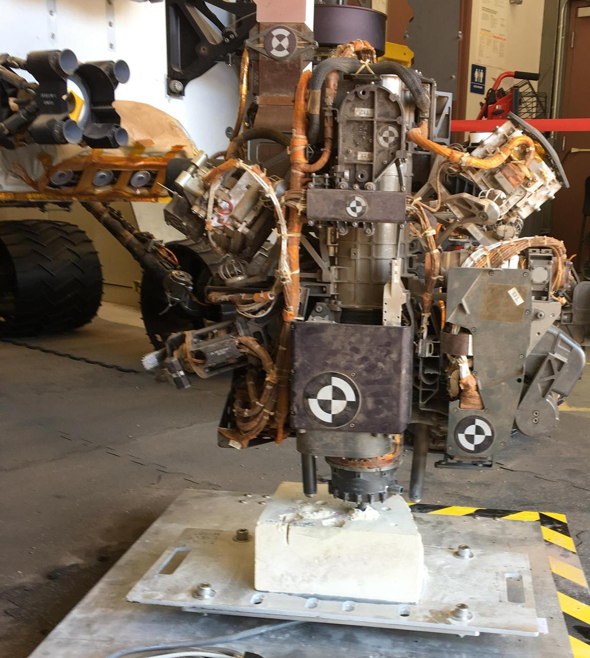
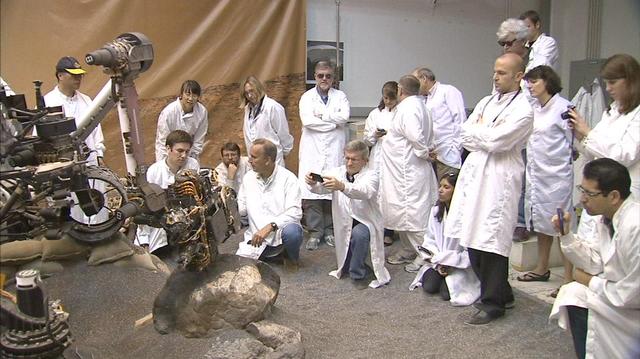
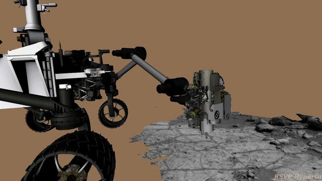
This photo taken in the "Mars Yard" at NASA's Jet Propulsion Laboratory, Pasadena, California, on Aug. 1, 2017, shows a step in development of possible alternative techniques that NASA's Curiosity Mars rover might be able to use to resume drilling into rocks on Mars. In late 2016, after Curiosity's drill had collected sample material from 15 Martian rocks in four years, the drill's feed mechanism ceased working reliably. That motorized mechanism moved the bit forward or back with relation to stabilizer posts on either side of the bit. In normal drilling by Curiosity, the stabilizers were positioned on the target rock first, and then the feed mechanism extended the rotation-percussion bit into the rock. In the alternative technique seen here, called "feed-extended drilling," the test rover's stabilizers are not used to touch the rock. The bit is advanced into the rock by motion of the robotic arm rather than the drill's feed mechanism. https://photojournal.jpl.nasa.gov/catalog/PIA22062
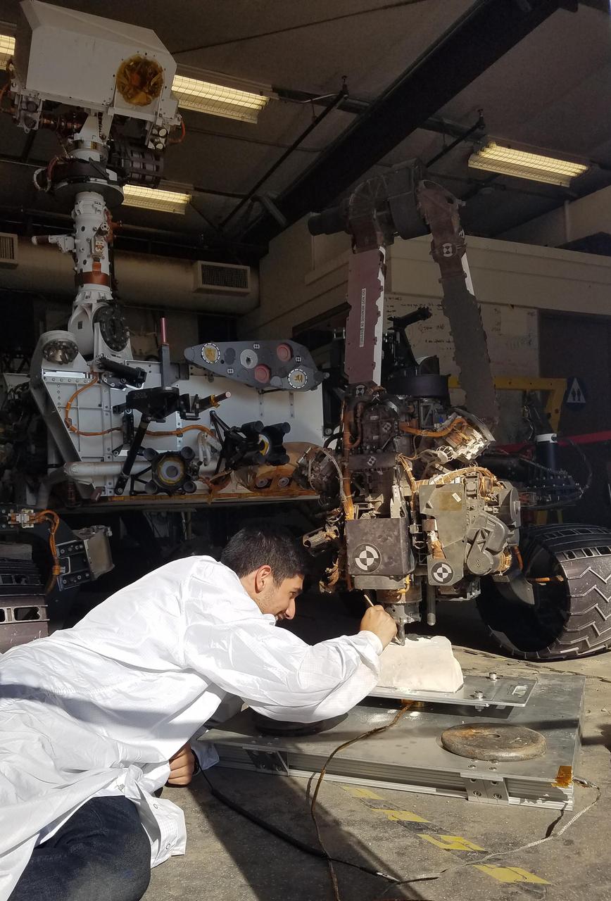
In the summer and fall of 2017, the team operating NASA's Curiosity Mars rover conducted tests in the "Mars Yard" at NASA's Jet Propulsion Laboratory, Pasadena, California, to develop techniques that Curiosity might be able to use to resume drilling into rocks on Mars. JPL robotics engineer Vladimir Arutyunov, in this June 29, 2017, photo, checks the test rover's drill bit at its contact point with a rock. Note that the stabilizer post visible to the right of the bit is not in contact with the rock, unlike the positioning used and photographed by Curiosity when drilling into rocks on Mars in 2013 to 2016. In late 2016, after Curiosity's drill had collected sample material from 15 Martian rocks, the drill's feed mechanism ceased working reliably. That motorized mechanism moved the bit forward or back with relation to the stabilizer posts on either side of the bit. In normal drilling by Curiosity, the stabilizers were positioned on the target rock first, and then the feed mechanism extended the rotation-percussion bit into the rock. In the alternative technique seen here, called "feed-extended drilling," the test rover's stabilizers are not used to touch the rock. The bit is advanced into the rock by motion of the robotic arm rather than the drill's feed mechanism. https://photojournal.jpl.nasa.gov/catalog/PIA22061
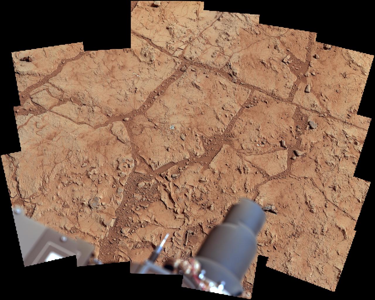
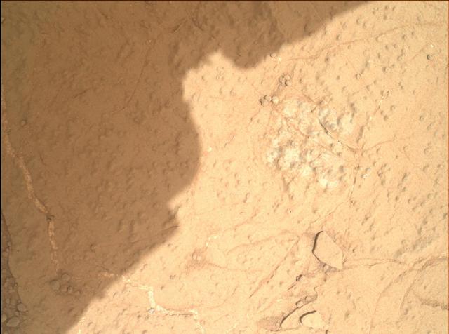
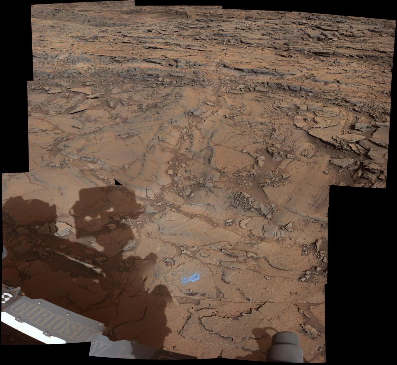
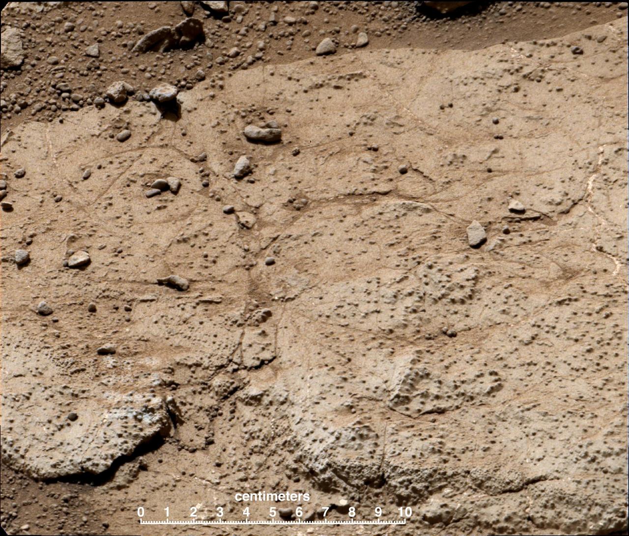
This image shows the first holes drilled by NASA Mars rover Curiosity at Mount Sharp. The loose material near the drill holes is drill tailings and an accumulation of dust that slid down the rock during drilling.
A Fresh Crater Drills to Tharsis Bedrock
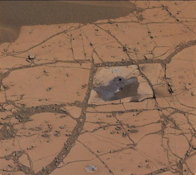
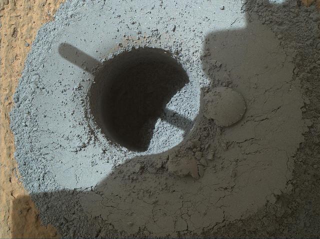
NASA's Curiosity Mars rover used a new drill method to produce a hole on Feb. 26, 2018, in a target named Lake Orcadie. The hole marks the first operation of the rover's drill since a motor problem began acting up more than a year ago. An early test produced a hole about a half-inch (1-centimeter) deep at Lake Orcadie --- not enough for a full scientific sample, but enough to validate that the new method works mechanically. This was just the first in what will be a series of tests to determine how well the new drill method can collect samples. A video is available at https://photojournal.jpl.nasa.gov/catalog/PIA22224

NASA is sending a mobile robot to the south pole of the Moon to get a close-up view of the location and concentration of water ice in the region and for the first time ever, actually sample the water ice at the same pole where the first woman and next man will land in 2024 under the Artemis program. About the size of a golf cart, the Volatiles Investigating Polar Exploration Rover, or VIPER, will roam several miles, using its four science instruments — including a 1-meter drill — to sample various soil environments. Planned for delivery in December 2022, VIPER will collect about 100 days of data that will be used to inform development of the first global water resource maps of the Moon. Illustration by Daniel Rutter.
This view from the Mast Camera (Mastcam) on NASA's Curiosity Mars rover shows the rover's drill just after finishing a drilling operation at a target rock called "Telegraph Peak" on Feb. 24, 2015, the 908th Martian day, or sol, of the rover's work on Mars. Three sols later, a fault-protection action by the rover halted a process of transferring sample powder that was collected during this drilling. The image is in raw color, as recorded directly by the camera, and has not been white-balanced. The fault-protection event, triggered by an irregularity in electrical current, led to engineering tests in subsequent days to diagnose the underlying cause. http://photojournal.jpl.nasa.gov/catalog/PIA19145
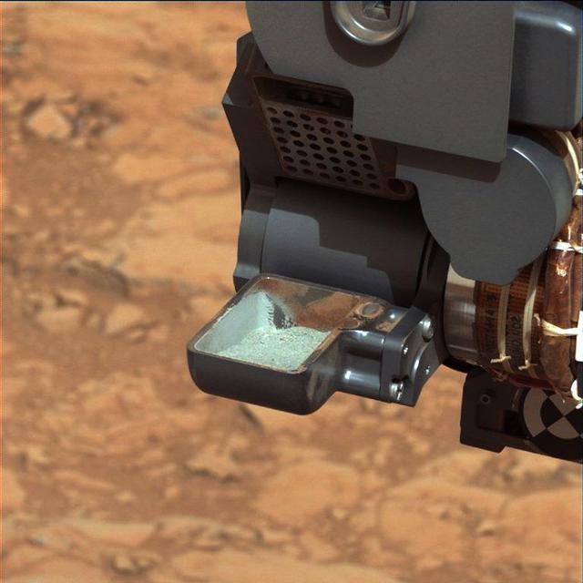
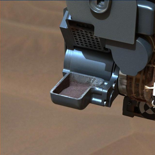
NASA Curiosity rover shows the first sample of powdered rock extracted by the rover drill. The image was taken after the sample was transferred from the drill to the rover scoop.
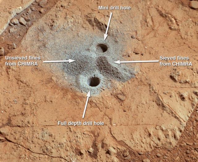
This view NASA Curiosity Mars Rover shows the rover drill in position for a mini-drill test to assess whether a rock target called Mojave is appropriate for full-depth drilling to collect a sample. It was taken on Jan. 13, 2015.
In an activity called the mini drill test, NASA Mars rover Curiosity used its drill to generate this ring of powdered rock for inspection in advance of the rover first full drilling.
NASA Mars rover Curiosity used its Mast Camera Mastcam to take the images combined into this mosaic of the drill area, called John Klein, where the rover ultimately performed its first sample drilling.
In this video, the robotic arm on NASA’s Perseverance Mars rover uses its percussive drill on a rocky outcrop near the rim of Jezero Crater that the science team calls “Kenmore” on June 10, 2025, the 1,531st Martian day, or sol, of the mission. Before drilling, the team abraded the rock to determine it was worthy of drilling. The eight images that make up this GIF were taken approximately one minute apart by one of the rover's front hazard-avoidance cameras. Animation available at https://photojournal.jpl.nasa.gov/catalog/PIA26575
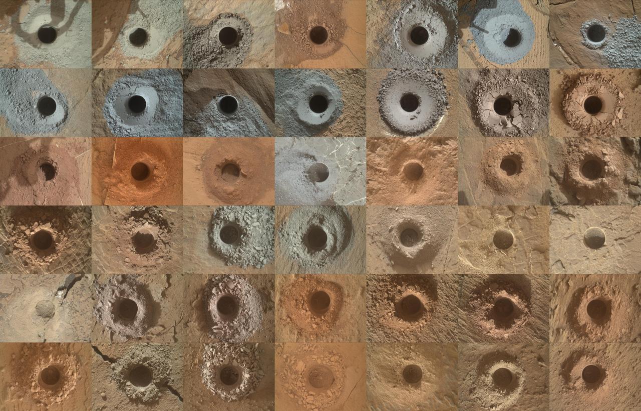
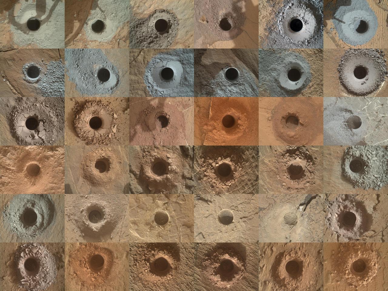
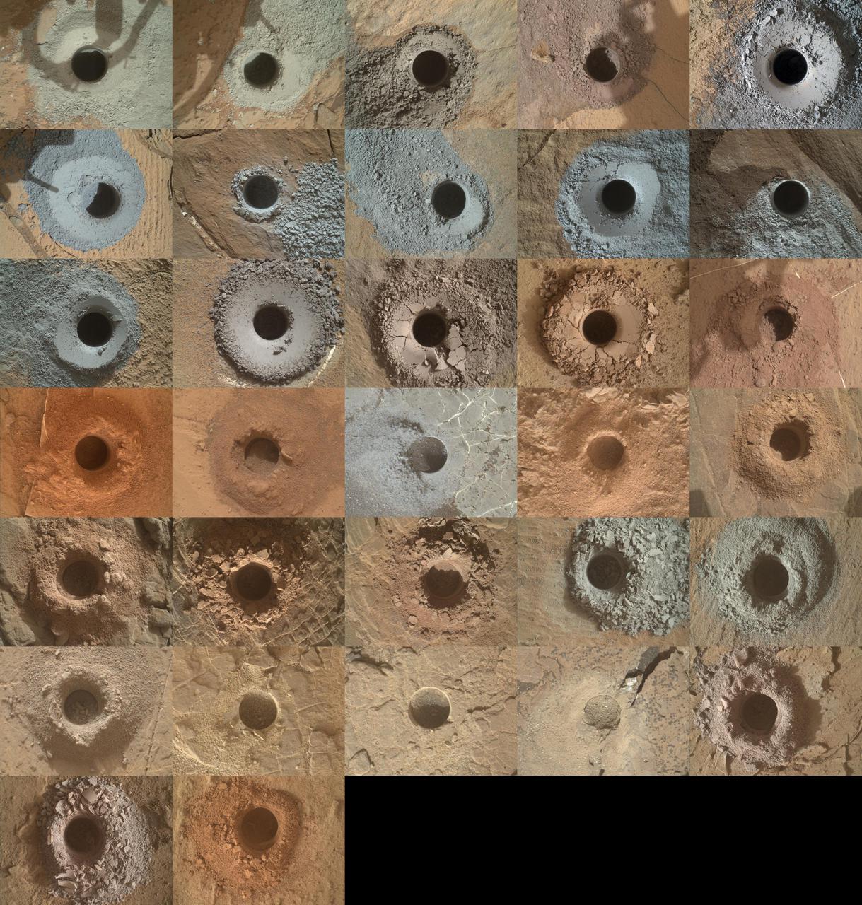
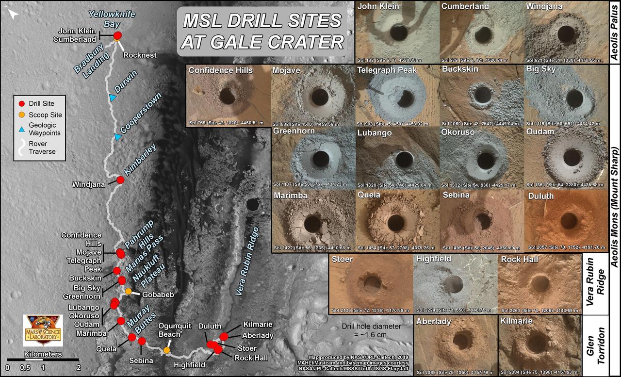
NASA's Curiosity Mars rover has collected 42 powderized rock samples with the drill on the end of its robotic arm. This grid shows all 42 holes made by the drill when collecting the samples, from "John Klein" (drilled on Feb. 9, 2013, the 182nd Martian day, or sol, of the mission) in the upper left, to "Kings Canyon" (drilled on Aug. 3, 2024, the 4,263rd Martian day, or sol, of the mission) in the lower right. Each hole is a little over a half-inch (16 millimeters) wide. The images were captured by the Mars Hand Lens Imager (MAHLI), a camera on the end of the rover's arm. After drilling a sample, the powderized rock is trickled into instruments inside of Curiosity's belly that can analyze the composition of the rocks. Those instruments include Sample Analysis at Mars (SAM) and Chemistry & Mineralogy (CheMin). https://photojournal.jpl.nasa.gov/catalog/PIA26403
This image from NASA Curiosity rover shows a sample of powdered rock extracted by the rover drill from the Confidence Hills target -- the first rock drilled after Curiosity reached the base of Mount Sharp in September 2014.
This image demonstrates how engineers place the drill carried by NASA Mars rover Curiosity onto rock targets. They first set down the drill two stabilizing prongs near the target, as shown by the dashed line.
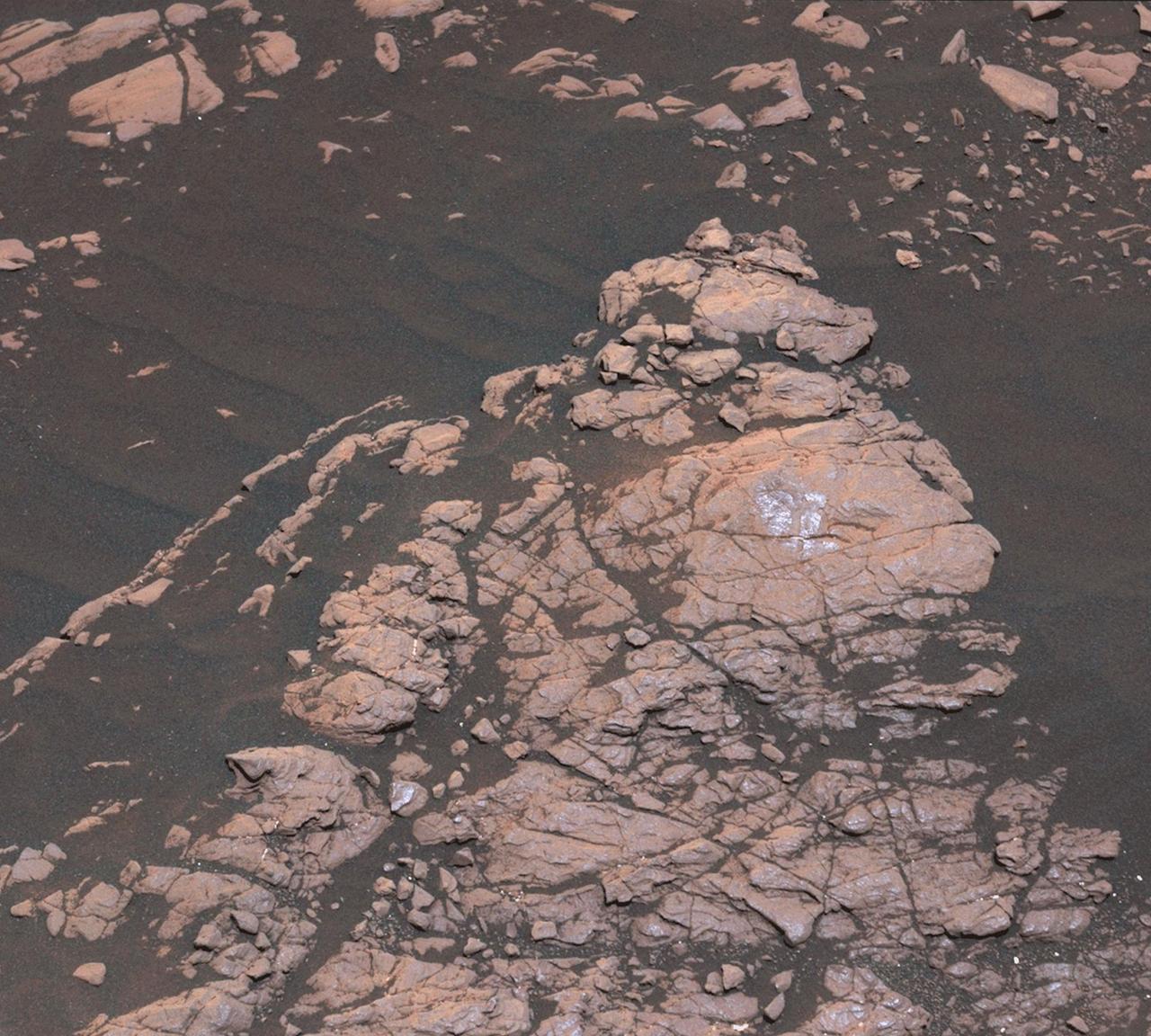
The Bonanza King rock on Mars, pictured here, was tapped by the drill belonging to NASA Mars rover Curiosity. The tapping resulted in sand piling up on the rock after drilling, showing the rock was not firmly in place.
A day after NASA Mars rover Curiosity drilled the first sample-collection hole into a rock on Mars, the rover Chemistry and Camera ChemCam instrument shot laser pulses into the fresh rock powder that the drilling generated.
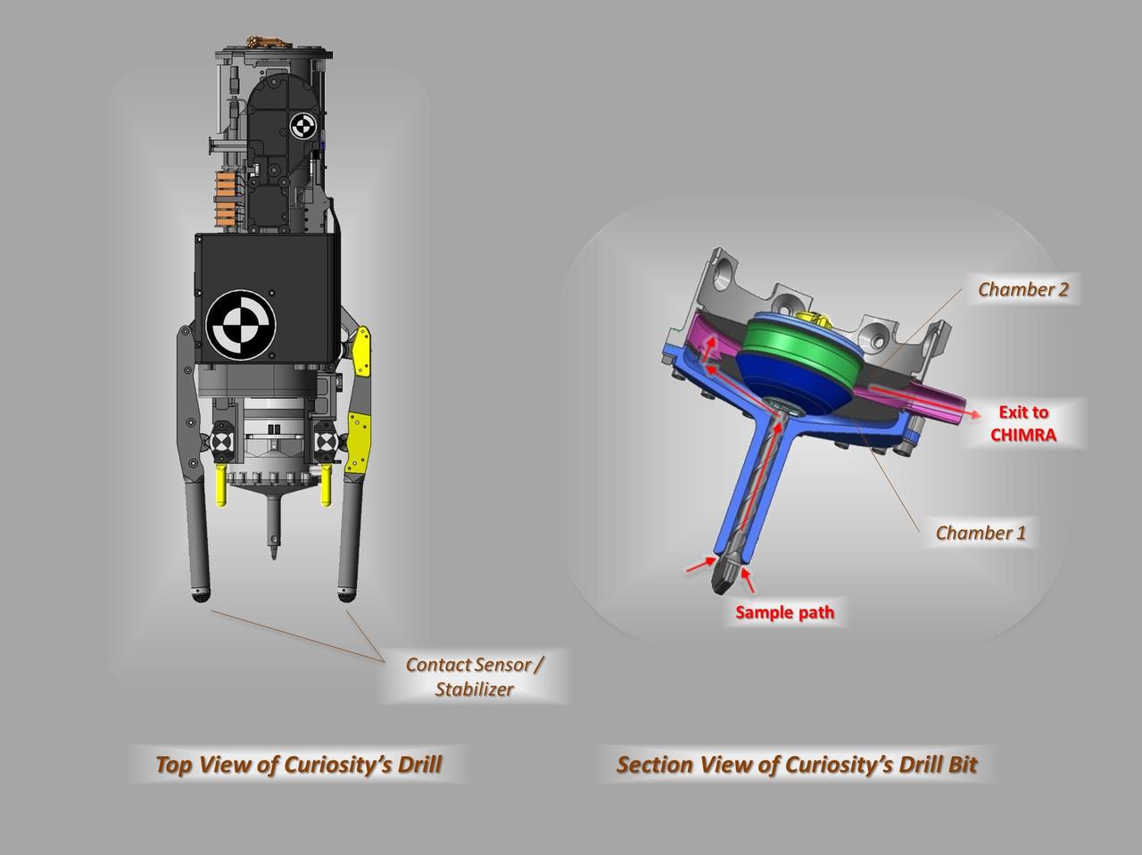
These schematic drawings show a top view and a cutaway view of a section of the drill on NASA Curiosity rover on Mars.
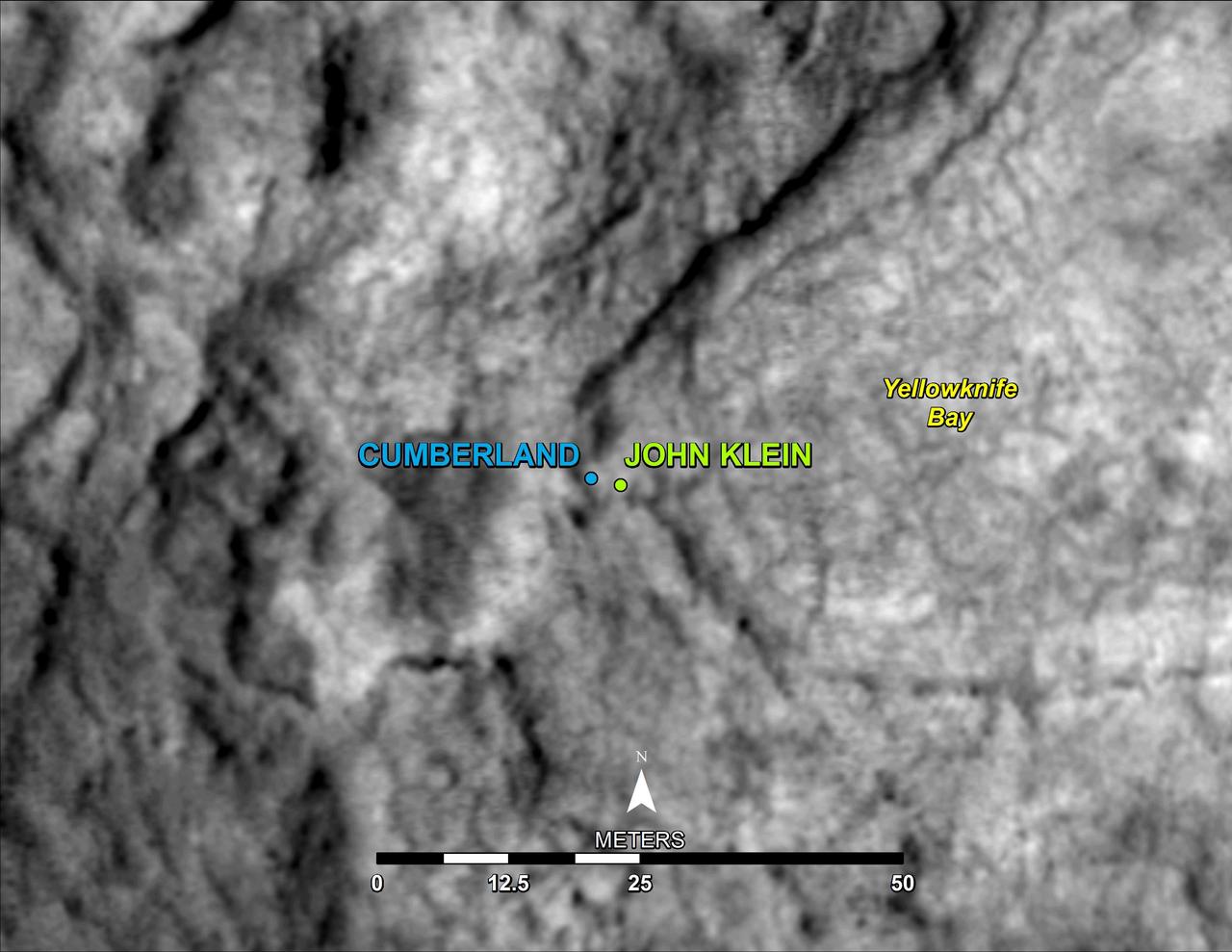
This map shows the location of Cumberland, the second rock-drilling target for NASA Mars rover Curiosity, in relation to the rover first drilling target, John Klein, within the southwestern lobe of a shallow depression called Yellowknife Bay.
This frame from an animation from NASA Mars rover Curiosity shows the rover drilling into rock target Cumberland. The drilling was performed during the 279th Martian day, or sol, of the Curiosity work on Mars May 19, 2013.
This Jan. 13, 2015, view from NASA Curiosity Mars rover shows outcomes of a mini-drill test to assess whether the Mojave rock is appropriate for full-depth drilling to collect a sample.
After an activity called the mini drill test by NASA Mars rover Curiosity, the rover MAHLI camera recorded this view of the results. The test generated a ring of powdered rock for inspection in advance of the rover first full drilling.
This image shows the first holes into rock drilled by NASA Mars rover Curiosity, with drill tailings around the holes plus piles of powdered rock collected from the deeper hole and later discarded.
This image from the front Hazcam on NASA Curiosity Mars rover shows the rover drill in place during a test of whether the rock beneath it, Bonanza King, would be an acceptable target for drilling to collect a sample.
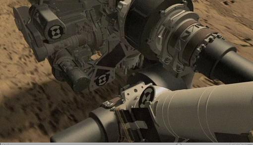
This frame from a video clip shows moments during a demonstration of drilling into a rock at NASA JPL, Pasadena, Calif., with a test double of the Mars rover Curiosity. The drill combines hammering and rotation motions of the bit.
This frame from an animation of NASA Curiosity rover shows the complicated suite of operations involved in conducting the rover first rock sample drilling on Mars and transferring the sample to the rover scoop for inspection.
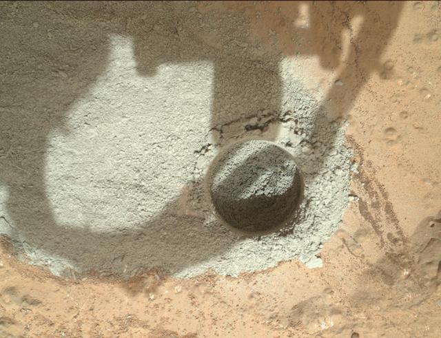
At the center of this image from NASA Curiosity rover is the hole in a rock called John Klein where the rover conducted its first sample drilling on Mars.
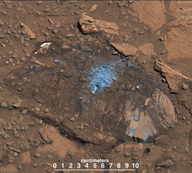
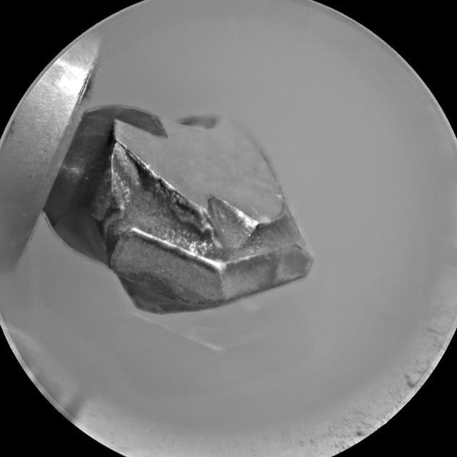
This image shows the Highfield drill hole made by NASA's Curiosity rover as it was collecting a sample on "Vera Rubin Ridge" in Gale Crater on Mars. Drill powder from this hole was enriched in carbon-12. The image was taken by the Mars Hand Lens Imager on Dec. 10, 2021, the 2,247th Martian day, or sol, of the mission. https://photojournal.jpl.nasa.gov/catalog/PIA25045
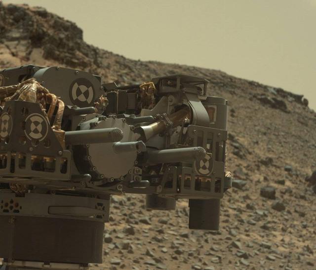
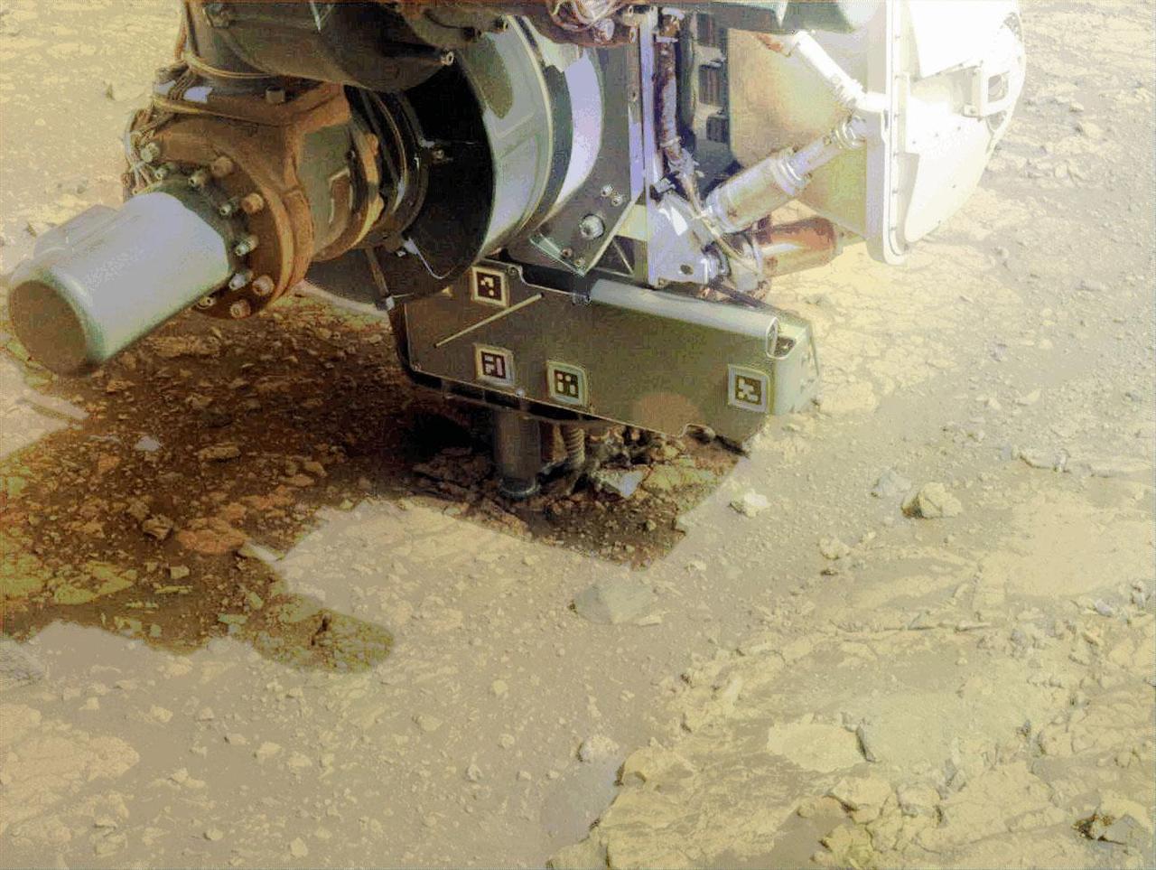
The percussion drill in the turret of tools at the end of the robotic arm of NASA Mars rover Curiosity has been positioned in contact with the rock surface in this image from the rover front Hazard-Avoidance Camera Hazcam.

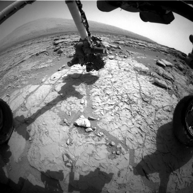
NASA's Curiosity Mars rover conducted a test on Oct. 17, 2017, as part of the rover team's development of a new way to use the rover's drill. This image from Curiosity's front Hazard Avoidance Camera (Hazcam) shows the drill's bit touching the ground during an assessment of measurements by a sensor on the rover's robotic arm. Curiosity used its drill to acquire sample material from Martian rocks 15 times from 2013 to 2016. In December 2016, the drill's feed mechanism stopped working reliably. During the test shown in this image, the rover touched the drill bit to the ground for the first time in 10 months. The image has been adjusted to brighten shaded areas so that the bit is more evident. The date was the 1,848th Martian day, or sol, of Curiosity's work on Mars In drill use prior to December 2016, two contact posts -- the stabilizers on either side of the bit -- were placed on the target rock while the bit was in a withdrawn position. Then the motorized feed mechanism within the drill extended the bit forward, and the bit's rotation and percussion actions penetrated the rock. A promising alternative now under development and testing -- called feed-extended drilling -- uses motion of the robotic arm to directly advance the extended bit into a rock. In this image, the bit is touching the ground but the stabilizers are not. In the Sol 1848 activity, Curiosity pressed the drill bit downward, and then applied smaller sideways forces while taking measurements with a force/torque sensor on the arm. The objective was to gain understanding about how readings from the sensor can be used during drilling to adjust for any sideways pressure that might risk the bit becoming stuck in a rock. While rover-team engineers are working on an alternative drilling method, the mission continues to examine sites on Mount Sharp, Mars, with other tools. https://photojournal.jpl.nasa.gov/catalog/PIA22063

Northwestern North Dakota is one of the least-densely populated parts of the United States. Cities and people are scarce, but satellite imagery shows the area has been aglow at night in recent years. The reason: the area is home to the Bakken shale formation, a site where gas and oil production are booming. On November 12, 2012, the Visible Infrared Imaging Radiometer Suite (VIIRS) on the Suomi NPP satellite captured this nighttime view of widespread drilling throughout the area. Most of the bright specks are lights associated with drilling equipment and temporary housing near drilling sites, though a few are evidence of gas flaring. Some of the brighter areas correspond to towns and cities including Williston, Minot, and Dickinson. The image was captured by the VIIRS “day-night band,” which detects light in a range of wavelengths from green to near-infrared and uses “smart” light sensors to observe dim signals such as gas flares, auroras, wildfires, city lights, and reflected moonlight. When VIIRS acquired the image, the Moon was in its waning crescent phase, so the landscape was reflecting only a small amount of light. According to the U.S. Energy Information Administration, natural gas production from the Bakken shale has increased more than 20-fold between 2007 and 2010. Gas production averaged over 485 million cubic feet per day in September 2011, compared to the 2005 average of about 160 million cubic feet per day. Due to the lack of a gas pipeline and processing facilities in the region, about 29 percent of that gas is flared. NASA Earth Observatory image by Jesse Allen and Robert Simmon, using VIIRS Day-Night Band data from the Suomi National Polar-orbiting Partnership. Suomi NPP is the result of a partnership between NASA, the National Oceanic and Atmospheric Administration, and the Department of Defense. Caption by Adam Voiland. Instrument: Suomi NPP - VIIRS Credit: <b><a href="http://www.earthobservatory.nasa.gov/" rel="nofollow"> NASA Earth Observatory</a></b> <b>Click here to view all of the <a href="http://earthobservatory.nasa.gov/Features/NightLights/" rel="nofollow"> Earth at Night 2012 images </a></b> <b>Click here to <a href="http://earthobservatory.nasa.gov/NaturalHazards/view.php?id=79810" rel="nofollow"> read more </a> about this image </b> <b><a href="http://www.nasa.gov/audience/formedia/features/MP_Photo_Guidelines.html" rel="nofollow">NASA image use policy.</a></b> <b><a href="http://www.nasa.gov/centers/goddard/home/index.html" rel="nofollow">NASA Goddard Space Flight Center</a></b> enables NASA’s mission through four scientific endeavors: Earth Science, Heliophysics, Solar System Exploration, and Astrophysics. Goddard plays a leading role in NASA’s accomplishments by contributing compelling scientific knowledge to advance the Agency’s mission. <b>Follow us on <a href="http://twitter.com/NASA_GoddardPix" rel="nofollow">Twitter</a></b> <b>Like us on <a href="http://www.facebook.com/pages/Greenbelt-MD/NASA-Goddard/395013845897?ref=tsd" rel="nofollow">Facebook</a></b> <b>Find us on <a href="http://instagram.com/nasagoddard?vm=grid" rel="nofollow">Instagram</a></b>
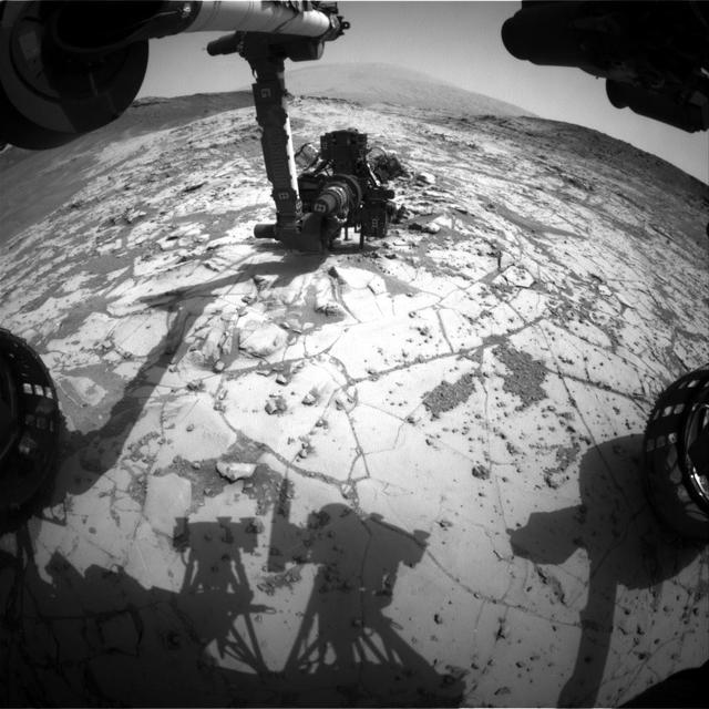
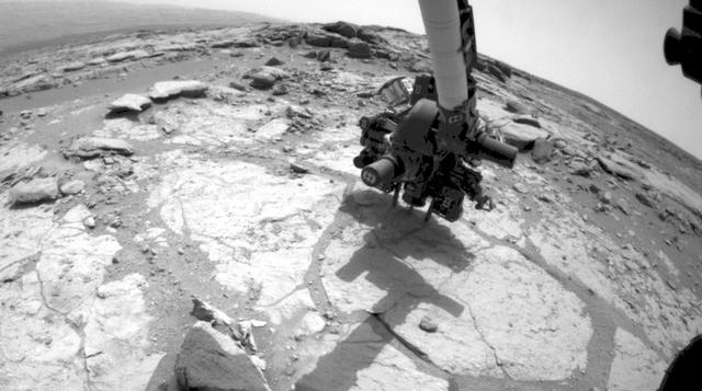
The rover is positioned at a patch of flat outcrop called John Klein, which was selected as the site for the first rock-drilling activities by NASA Curiosity. This self-portrait was acquired to document the drilling site.
The bit in the rotary-percussion drill of NASA Mars rover Curiosity left its mark in a target patch of rock called John Klein during a test on Feb. 2, 2013, in preparation for the first drilling of a rock by the rover.
NASA's Curiosity Mars rover has collected 36 powderized rock samples with the drill on the end of its robotic arm. This grid shows all 36 holes to date. The images in the grid were captured by the Mars Hand Lens Imager (MAHLI) on the end of Curiosity's arm. https://photojournal.jpl.nasa.gov/catalog/PIA25416
NASA's Curiosity Mars rover used its Mast Camera, or Mastcam, to capture this image of its 36th successful drill hole on Mount Sharp, at a rock called "Canaima." The pulverized sample of this rock was drilled on Oct. 3, 2022, the 3,612th Martian day, or sol, of the mission. https://photojournal.jpl.nasa.gov/catalog/PIA25418
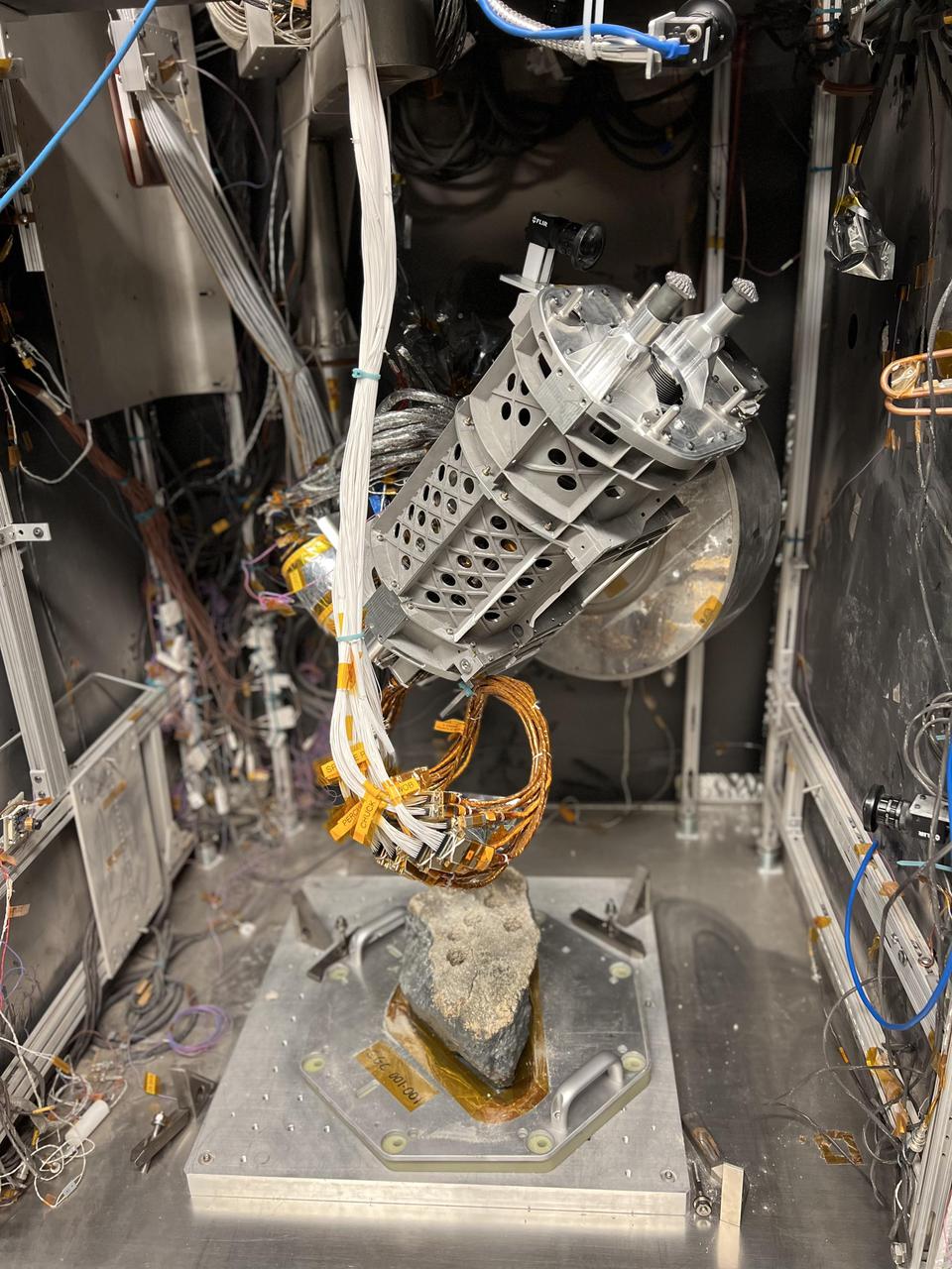
This drill is a duplicate of the one aboard NASA's Perseverance Mars rover. It was used in a test campaign at NASA's Jet Propulsion Laboratory in Southern California to learn how crumbly rocks respond to the drill. A key objective for Perseverance's mission on Mars is astrobiology, including the search for signs of ancient microbial life. The rover will characterize the planet's geology and past climate, pave the way for human exploration of the Red Planet, and be the first mission to collect and cache Martian rock and regolith (broken rock and dust). Subsequent NASA missions, in cooperation with ESA (European Space Agency), would send spacecraft to Mars to collect these sealed samples from the surface and return them to Earth for in-depth analysis. The Mars 2020 Perseverance mission is part of NASA's Moon to Mars exploration approach, which includes Artemis missions to the Moon that will help prepare for human exploration of the Red Planet. https://photojournal.jpl.nasa.gov/catalog/PIA25050
NASA Curiosity Mars rover completed a shallow mini drill test April 29, 2014, in preparation for full-depth drilling at a rock target called Windjana. The hole results from the test is 0.63 inch across and about 0.8 inch deep.
This hole, with a diameter slightly smaller than a U.S. dime, was drilled by NASA Curiosity Mars rover into a rock target called Telegraph Peak. The rock is located within the basal layer of Mount Sharp. The hole was drilled on Feb. 24, 2015.
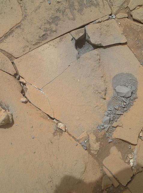
This view shows the patch of veined, flat-lying rock selected as the first drilling site for NASA Mars rover Curiosity.
This wide view of the John Klein location selected for the first rock drilling by NASA Mars rover Curiosity is a mosaic taken by Curiosity right Mast Camera Mastcam.
This view from the Mast Camera (Mastcam) on NASA's Curiosity Mars rover covers an area in "Bridger Basin" that includes the locations where the rover drilled a target called "Big Sky" on the mission's Sol 1119 (Sept. 29, 2015) and a target called "Greenhorn" on Sol 1137 (Oct. 18, 2015). The scene combines portions of several observations taken from sols 1112 to 1126 (Sept. 22 to Oct. 6, 2015) while Curiosity was stationed at Big Sky drilling site. The Big Sky drill hole is visible in the lower part of the scene. The Greenhorn target, in a pale fracture zone near the center of the image, had not yet been drilled when the component images were taken. Researchers selected this pair of drilling sites to investigate the nature of silica enrichment in the fracture zones of the area. http://photojournal.jpl.nasa.gov/catalog/PIA20270
The Mast Camera, or Mastcam, on NASA's Curiosity Mars rover captured this set of images before and after it drilled a rock nicknamed "Aberlady," on Saturday, April 6, 2019 (the 2,370th Martian day, or sol, of the mission). The rock and others nearby appear to have moved when the drill was retracted. This was the first time Curiosity has drilled in the long-awaited "clay-bearing unit." The scene is presented with a color adjustment that approximates white balancing to resemble how the rocks and sand would appear under daytime lighting conditions on Earth. Movie available at https://photojournal.jpl.nasa.gov/catalog/PIA23138
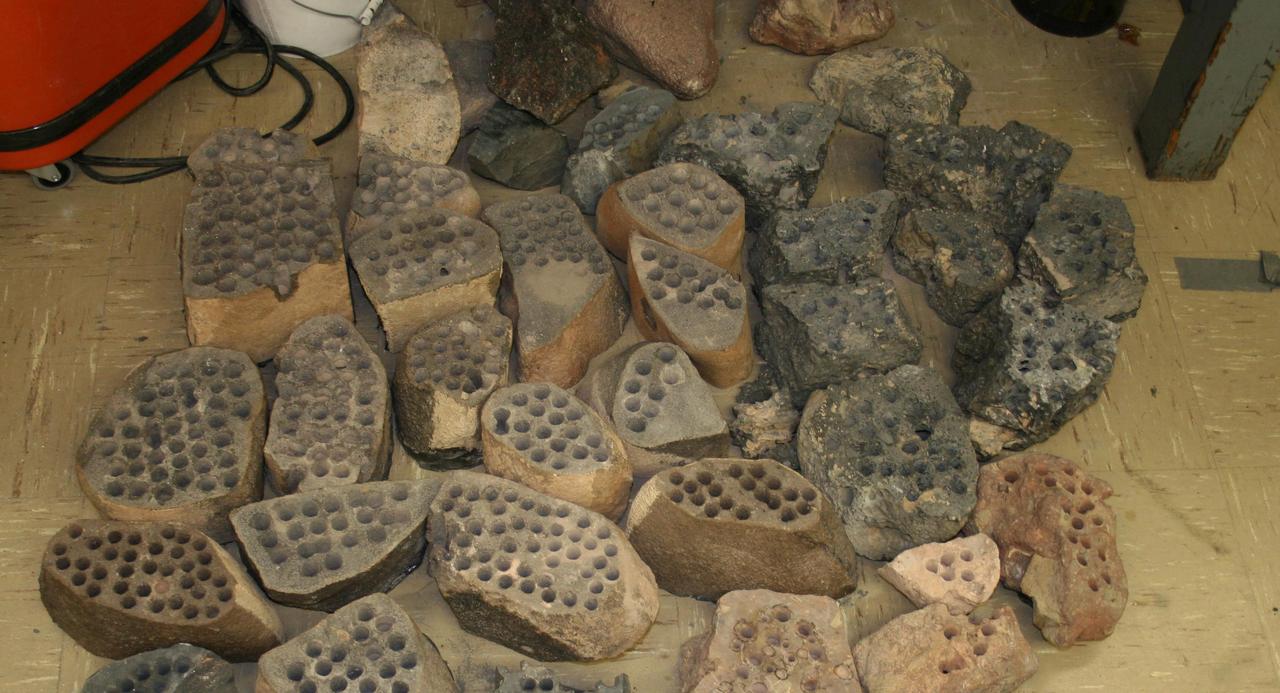
The development of the Mars rover Curiosity capabilities for drilling into a rock on Mars required years of development work. Seen here are some of the rocks used in bit development testing and lifespan testing at JPL in 2007.
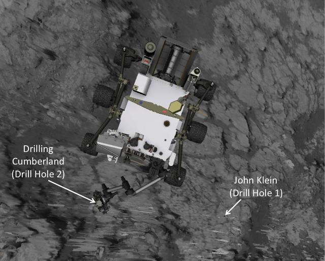
This image produced from software used for planning drives of NASA Mars rover Curiosity depicts the location and size of the rover when it was driven into position for drilling into rock target Cumberland.
This frame from a set of three images from NASA Curiosity rover shows the rover drill in action on Feb. 8, 2013, or Sol 182, Curiosity 182nd Martian day of operations.
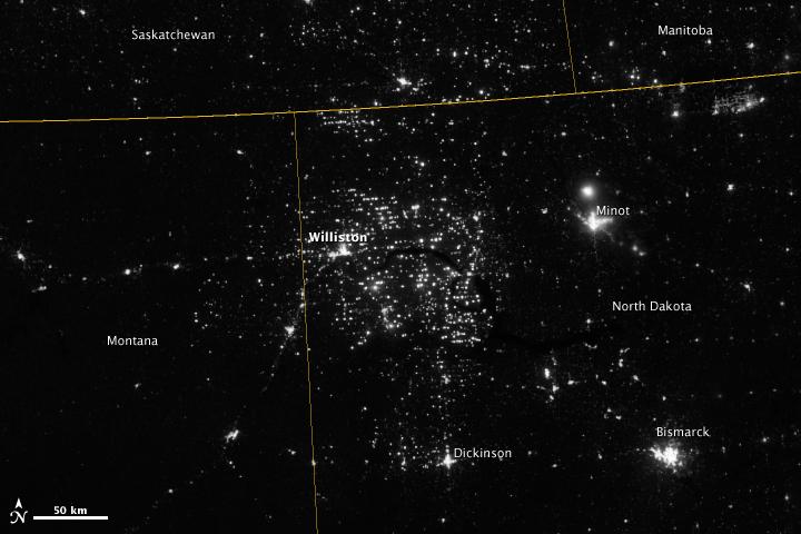
Northwestern North Dakota is one of the least-densely populated parts of the United States. Cities and people are scarce, but satellite imagery shows the area has been aglow at night in recent years. The reason: the area is home to the Bakken shale formation, a site where oil production is booming. Companies hoping to extract oil from the Bakken formation have drilled hundreds of new wells in the last few years; natural gas often bubbles up to the surface as part of the process. Lacking the infrastructure to pipe the gas away, many drillers simply burn it in a practice known as flaring. On November 12, 2012, the Visible Infrared Imaging Radiometer Suite (VIIRS) on the Suomi NPP satellite captured this nighttime view of widespread gas flaring throughout the area. Many of the specks of light are evidence of gas flaring, though others may be the lights around drilling equipment. Some of the brighter areas correspond to towns and cities including Williston, Minot, and Dickinson. The image was captured by the VIIRS “day-night band,” which detects light in a range of wavelengths from green to near-infrared and uses filtering techniques to observe signals such as gas flares, auroras, wildfires, city lights, and reflected moonlight. When VIIRS acquired the image, the moon was in its waning crescent phase, meaning it was reflecting only a small amount of light. According to the U.S. Energy Information Administration, natural gas production from the Bakken shale has increased more than 20-fold between 2007 and 2010. Gas production averaged over 485 million cubic feet per day in September 2011, compared to the 2005 average of about 160 million cubic feet per day. Due to the lack of gas pipeline and processing facilities in the region, about 29 percent of that gas is flared. NASA Earth Observatory image by Jesse Allen and Robert Simmon, using VIIRS Day-Night Band data from the Suomi National Polar-orbiting Partnership. Suomi NPP is the result of a partnership between NASA, the National Oceanic and Atmospheric Administration, and the Department of Defense. Caption by Adam Voiland. Instrument: Suomi NPP - VIIRS Credit: <b><a href="http://www.earthobservatory.nasa.gov/" rel="nofollow"> NASA Earth Observatory</a></b> <b>Click here to view all of the <a href="http://earthobservatory.nasa.gov/Features/NightLights/" rel="nofollow"> Earth at Night 2012 images </a></b> <b>Click here to <a href="http://earthobservatory.nasa.gov/NaturalHazards/view.php?id=79810" rel="nofollow"> read more </a> about this image </b> <b><a href="http://www.nasa.gov/audience/formedia/features/MP_Photo_Guidelines.html" rel="nofollow">NASA image use policy.</a></b> <b><a href="http://www.nasa.gov/centers/goddard/home/index.html" rel="nofollow">NASA Goddard Space Flight Center</a></b> enables NASA’s mission through four scientific endeavors: Earth Science, Heliophysics, Solar System Exploration, and Astrophysics. Goddard plays a leading role in NASA’s accomplishments by contributing compelling scientific knowledge to advance the Agency’s mission. <b>Follow us on <a href="http://twitter.com/NASA_GoddardPix" rel="nofollow">Twitter</a></b> <b>Like us on <a href="http://www.facebook.com/pages/Greenbelt-MD/NASA-Goddard/395013845897?ref=tsd" rel="nofollow">Facebook</a></b> <b>Find us on <a href="http://instagram.com/nasagoddard?vm=grid" rel="nofollow">Instagram</a></b>

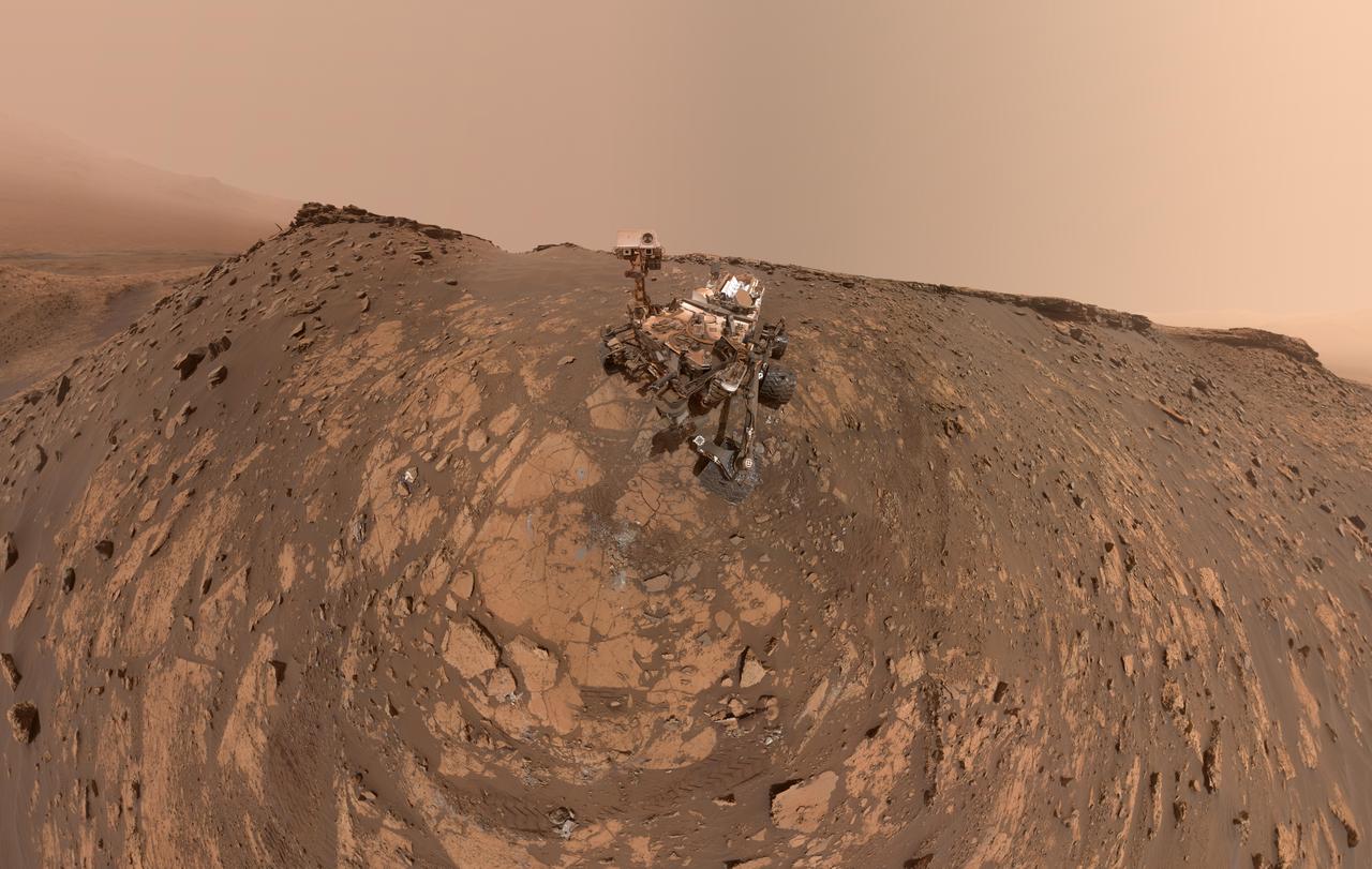
This self-portrait of NASA's Curiosity Mars rover shows the vehicle at a drilled sample site called "Okoruso," on the "Naukluft Plateau" of lower Mount Sharp. The scene combines multiple images taken with the rover's Mars Hand Lens Imager (MAHLI) on May 11, 2016, during the 1,338th Martian day, or sol, of the rover's work on Mars. In front of the rover is the hole, surrounded by grayish drill cuttings, created by using Curiosity's drill to collect sample rock powder at Okoruo, plus a patch of powder dumped onto the ground after delivery of a portion to the rover's internal Chemistry and Mineralogy (CheMin) laboratory instrument. The rover team compared the rock powder from drilling at Okoruso to material from the nearby "Lubango" drilling site, which is visible behind the rover, just to the left of the mast. The Lubango site was selected within a pale zone, or "halo," beside a fracture in the area's sandstone bedrock. Okoruso is in less-altered bedrock farther from any fractures. Note that the Okoruso drill cuttings appear darker than the Lubango drill cuttings. The Lubango sample was found to be enriched in silica and sulfates, relative to Okoruso. To the left of the rover, in this scene, several broken rocks reveal grayish interiors. Here, Curiosity was driven over the rocks in a fracture-associated halo, so that freshly exposed surfaces could be examined with MAHLI, Mast Camera (Mastcam) and Chemistry and Camera (ChemCam) instruments. An upper portion of Mount Sharp is prominent on the horizon. http://photojournal.jpl.nasa.gov/catalog/PIA20602

This self-portrait of NASA Curiosity Mars rover shows the vehicle at a drilled sample site called Okoruso, on the Naukluft Plateau of lower Mount Sharp.
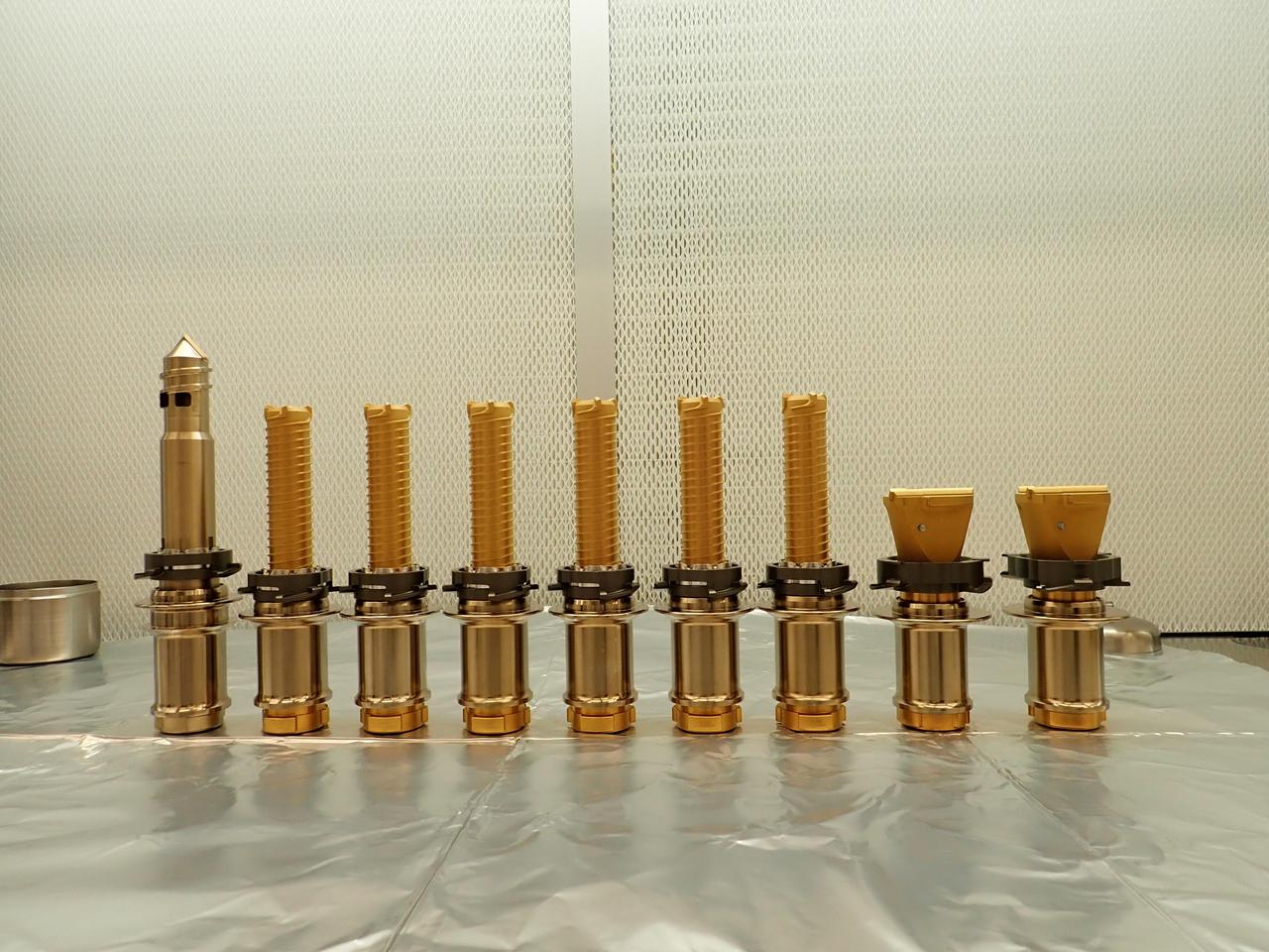
The drill bits used by NASA's Perseverance Mars rover are seen before being installed prior to launch. The regolith bit is on the left, followed by six bits used for drilling rock cores. On the right are two abrasion bits that are used to remove the dust-covered outer layer of a rock so that the rover can take accurate data of its composition. A key objective for Perseverance's mission on Mars is astrobiology, including the search for signs of ancient microbial life. The rover will characterize the planet's geology and past climate, pave the way for human exploration of the Red Planet, and be the first mission to collect and cache Martian rock and regolith (broken rock and dust). Subsequent NASA missions, in cooperation with ESA (European Space Agency), would send spacecraft to Mars to collect these sealed samples from the surface and return them to Earth for in-depth analysis. The Mars 2020 Perseverance mission is part of NASA's Moon to Mars exploration approach, which includes Artemis missions to the Moon that will help prepare for human exploration of the Red Planet. https://photojournal.jpl.nasa.gov/catalog/PIA25590
Lockheed Martin Photography By Garry Tice 1011 Lockheed Way, Palmdale, Ca. 93599 Event: SEG 410 Main Wing, COBRA Drillng Machine, Drilling Lower Wing Skins Date: 1/07/20 Additional Info:
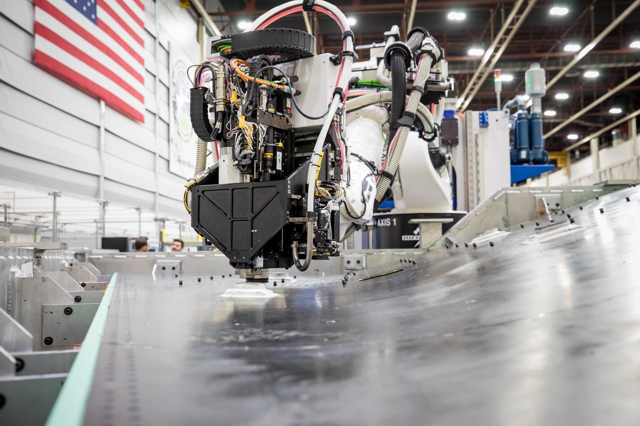
Lockheed Martin Photography By Garry Tice 1011 Lockheed Way, Palmdale, Ca. 93599 Event: SEG 410 Main Wing, COBRA Drillng Machine, Drilling Lower Wing Skins Date: 1/07/20 Additional Info:

Lockheed Martin Photography By Garry Tice 1011 Lockheed Way, Palmdale, Ca. 93599 Event: SEG 410 Main Wing, COBRA Drillng Machine, Drilling Lower Wing Skins Date: 1/07/20 Additional Info:
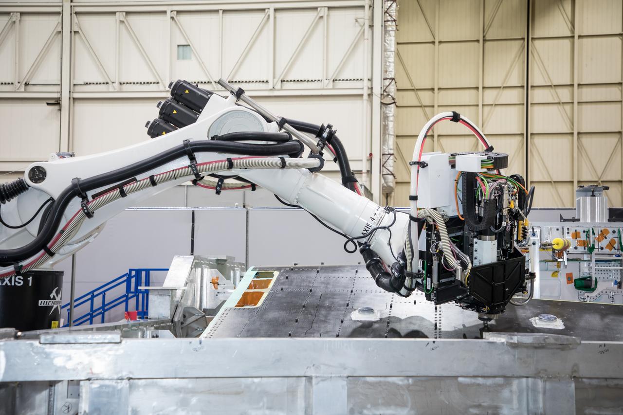
Lockheed Martin Photography By Garry Tice 1011 Lockheed Way, Palmdale, Ca. 93599 Event: SEG 410 Main Wing, COBRA Drillng Machine, Drilling Lower Wing Skins Date: 1/07/20 Additional Info:
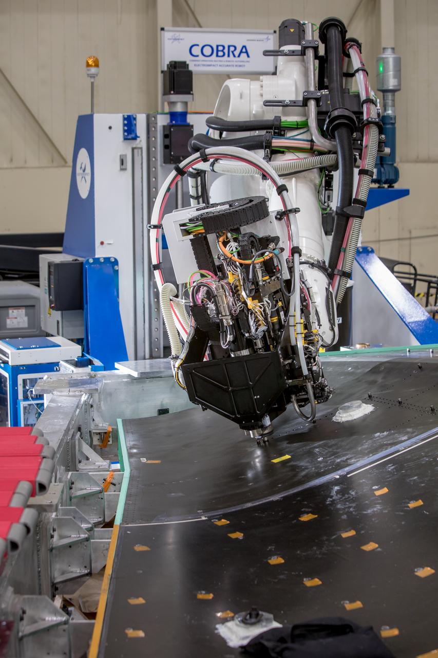
Lockheed Martin Photography By Garry Tice 1011 Lockheed Way, Palmdale, Ca. 93599 Event: SEG 410 Main Wing, COBRA Drillng Machine, Drilling Lower Wing Skins Date: 12/23/19 Additional Info:
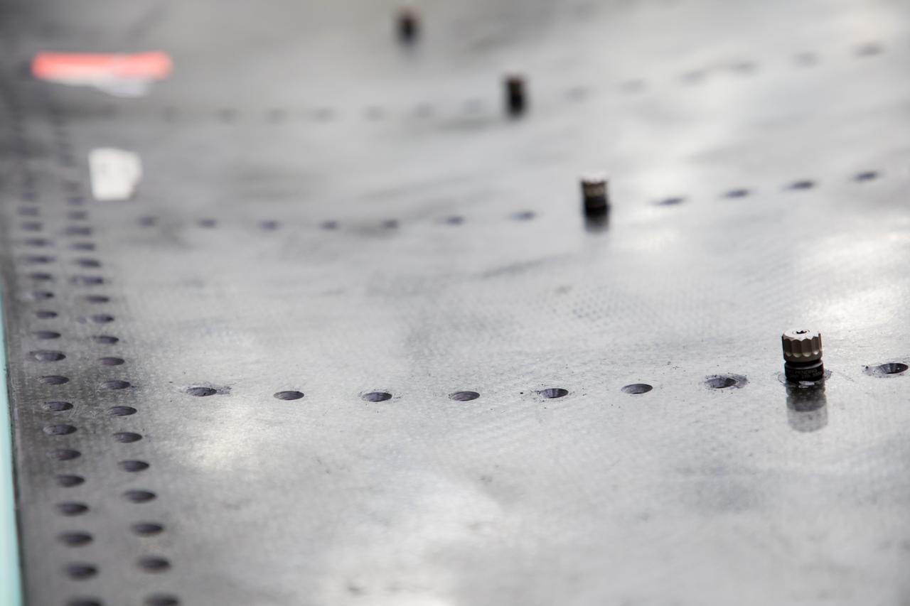
Lockheed Martin Photography By Garry Tice 1011 Lockheed Way, Palmdale, Ca. 93599 Event: SEG 410 Main Wing, COBRA Drillng Machine, Drilling Lower Wing Skins Date: 1/07/20 Additional Info:

Lockheed Martin Photography By Garry Tice 1011 Lockheed Way, Palmdale, Ca. 93599 Event: SEG 410 Main Wing, COBRA Drillng Machine, Drilling Lower Wing Skins Date: 1/07/20 Additional Info:
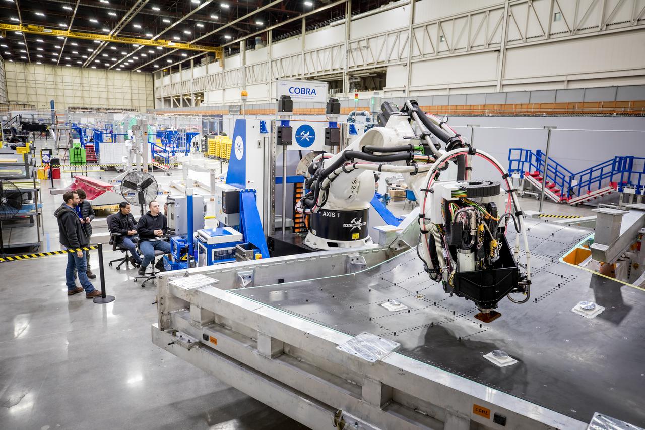
Lockheed Martin Photography By Garry Tice 1011 Lockheed Way, Palmdale, Ca. 93599 Event: SEG 410 Main Wing, COBRA Drillng Machine, Drilling Lower Wing Skins Date: 1/07/20 Additional Info:
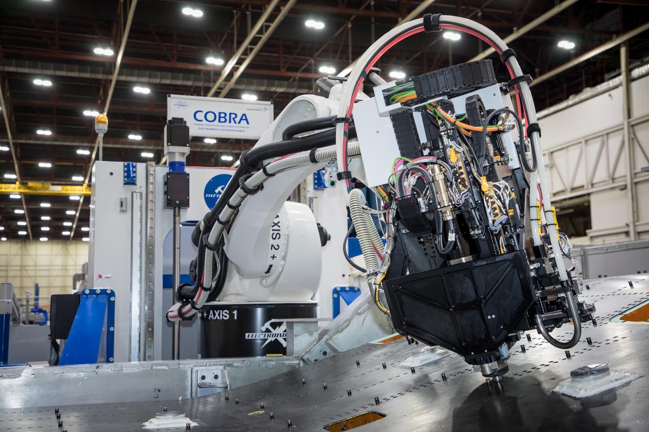
Lockheed Martin Photography By Garry Tice 1011 Lockheed Way, Palmdale, Ca. 93599 Event: SEG 410 Main Wing, COBRA Drillng Machine, Drilling Lower Wing Skins Date: 1/07/20 Additional Info:
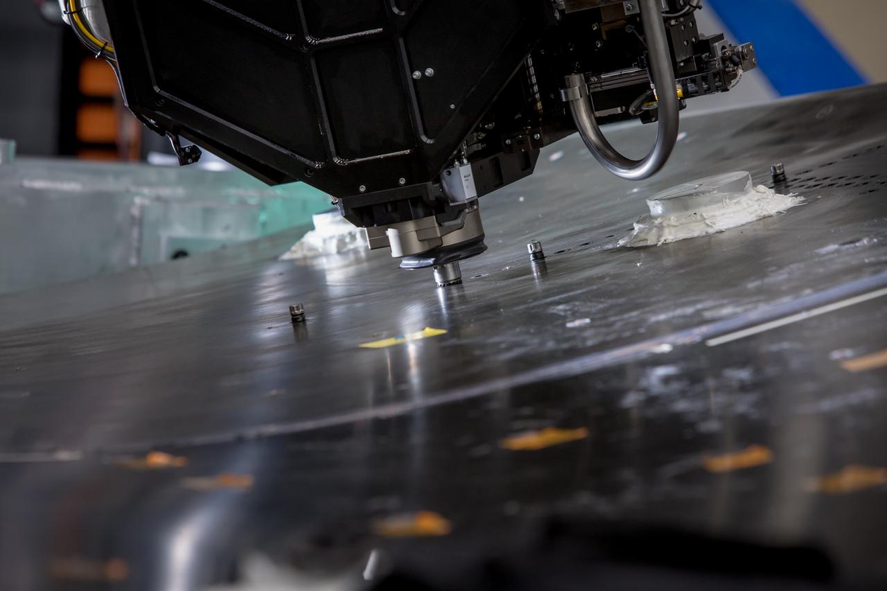
Lockheed Martin Photography By Garry Tice 1011 Lockheed Way, Palmdale, Ca. 93599 Event: SEG 410 Main Wing, COBRA Drillng Machine, Drilling Lower Wing Skins Date: 12/23/19 Additional Info:
The Chemistry and Camera ChemCam instrument on NASA Mars rover Curiosity was used to check the composition of gray tailings from the hole in rock target Cumberland that the rover drilled on May 19, 2013.
NASA's Curiosity Mars rover has used the drill on its robotic arm to take 32 rock samples to date. The Mars Hand Lens Imager (MAHLI), a camera on the end of the robotic arm, provided the images in this mosaic. https://photojournal.jpl.nasa.gov/catalog/PIA24764
A blink pair of images taken before and after NASA Curiosity performed a mini drill test on a Martian rock shows changes resulting from that activity.

The hole that NASA Curiosity Mars rover drilled into target rock John Klein provided a view into the interior of the rock, as well as obtaining a sample of powdered material from the rock.
The right Mast Camera Mastcam of NASA Curiosity Mars rover provided this contextual view of the vicinity of the location called John Klein, selected as Curiosity first drilling site.
This Aug. 12, 2012, image from the Mastcam on NASA Curiosity Mars rover shows an outcrop that includes the Bonanza King rock under consideration as a drilling target. Raised ridges on the flat rocks are visible at right.
Cumberland has been selected as the second target for drilling by NASA Mars rover Curiosity. The rover has the capability to collect powdered material from inside the target rock and analyze that powder with laboratory instruments.
This mosaic of images from NASA Curiosity shows geological members of the Yellowknife Bay formation, and the sites where Curiosity drilled into the lowest-lying member, called Sheepbed, at targets John Klein and Cumberland.
NASA Curiosity Mars rover used the MAHLI camera at the end of its arm in April and May 2014 to take dozens of component images combined into this self-portrait where the rover drilled into a sandstone target called Windjana.
NASA Mars rover Curiosity drilled into this rock target, Cumberland, during the 279th Martian day, or sol, of the rover work on Mars May 19, 2013 and collected a powdered sample of material from the rock interior.
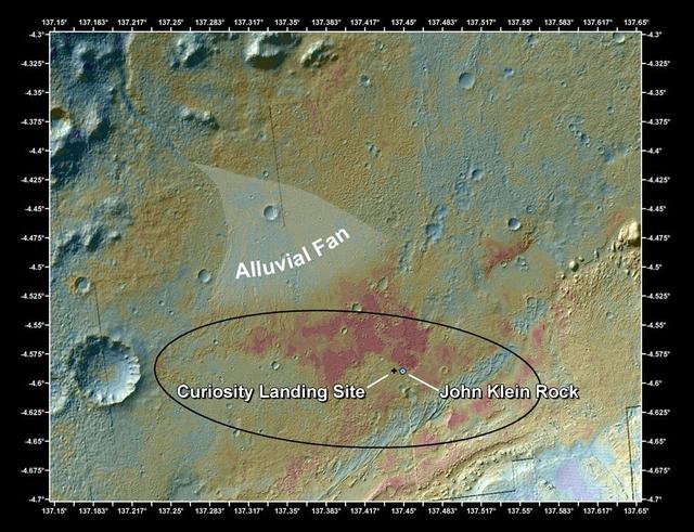
This false-color map shows the area within Gale Crater on Mars, where NASA Curiosity rover landed on Aug. 5, 2012 PDT Aug. 6, 2012 EDT and the location where Curiosity collected its first drilled sample at the John Klein rock.
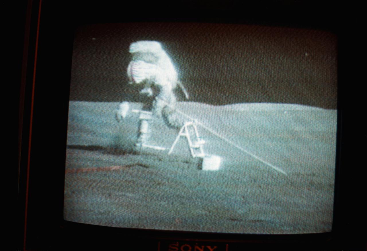
S71-41501 (1 Aug. 1971) --- Astronaut David R. Scott, Apollo 15 commander, is seen carrying the Apollo Lunar Surface Drill (ALSD) during the second lunar surface extravehicular activity (EVA) in this black and white reproduction taken from a color transmission made by the RCA color television camera mounted on the Lunar Roving Vehicle (LRV). This transmission was the fourth made during the mission.
This graphic maps locations of the sites where NASA's Curiosity Mars rover collected its rock and soil samples for analysis by laboratory instruments inside the vehicle. It also presents images of the drilled holes where 21 rock-powder samples were acquired. The diameter of each drill hole is about 0.6 inch (1.6 centimeters), slightly smaller than a U.S. dime. The images used here are raw color, as recorded by the rover's Mars Hand Lens Imager (MAHLI) camera. Notice the differences in color of the material at different drilling sites. For the map, north is toward upper left corner. The scale bar represents 2 kilometers (1.2 miles). The base map is from the High Resolution Imaging Science Experiment (HiRISE) camera on NASA's Mars Reconnaissance Orbiter. https://photojournal.jpl.nasa.gov/catalog/PIA23413
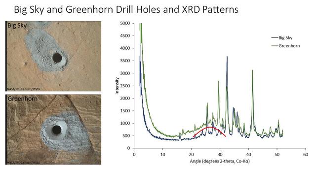
The graph at right presents information from the NASA Curiosity Mars rover's onboard analysis of rock powder drilled from the "Big Sky" and "Greenhorn" target locations, shown at left. X-ray diffraction analysis of the Greenhorn sample inside the rover's Chemistry and Mineralogy (CheMin) instrument revealed an abundance of silica in the form of noncrystalline opal. The broad hump in the background of the X-ray diffraction pattern for Greenhorn, compared to Big Sky, is diagnostic of opal. The image of Big Sky at upper left was taken by the rover's Mars Hand Lens Imager (MAHLI) camera the day the hole was drilled, Sept. 29, 2015, during the mission's 1,119th Martian day, or sol. The Greenhorn hole was drilled, and the MAHLI image at lower left was taken, on Oct. 18, 2015 (Sol 1137). http://photojournal.jpl.nasa.gov/catalog/PIA20272
This animation depicts NASA Mars rover Curiosity drilling a hole to collect a rock-powder sample at a target site called John
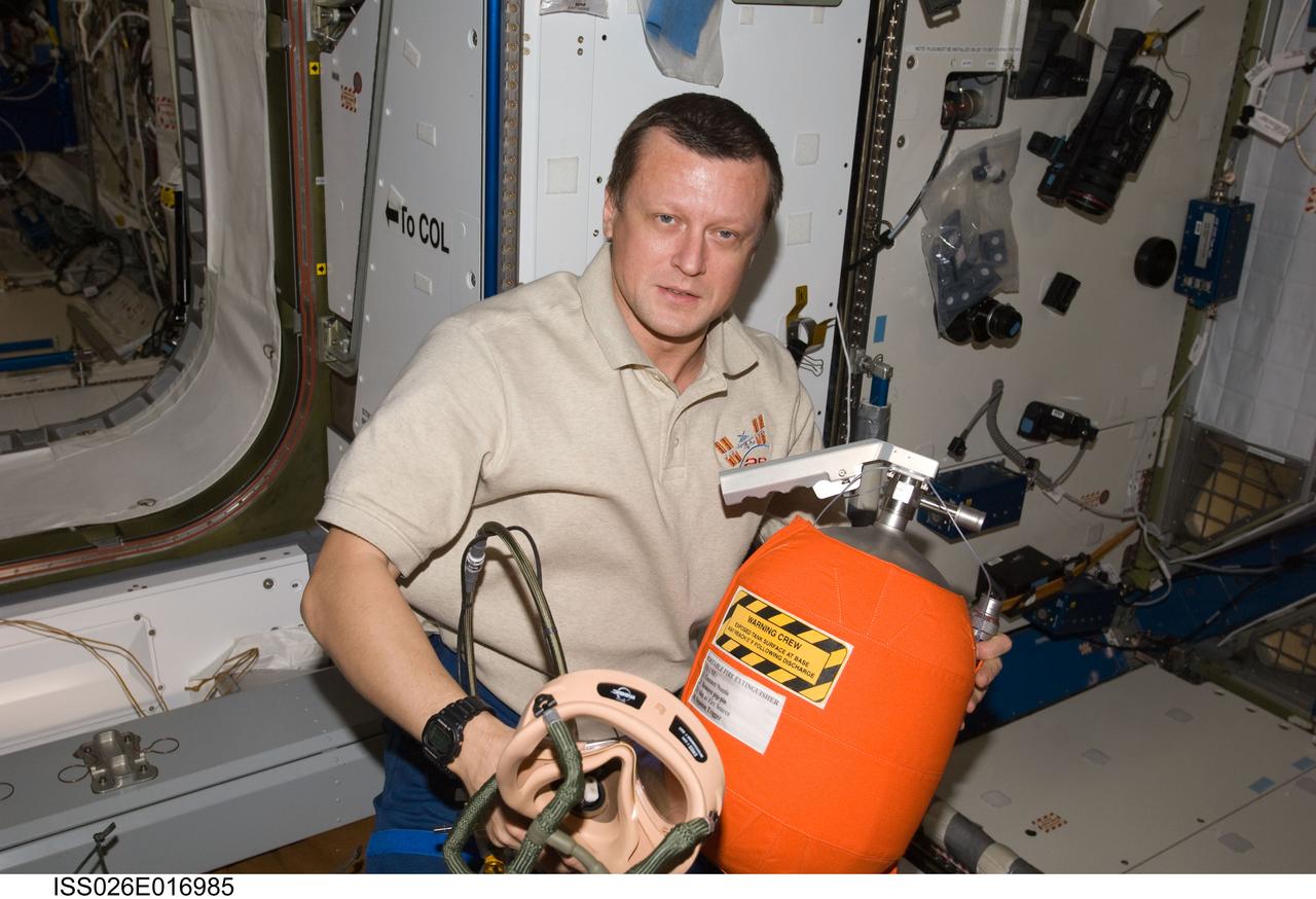
ISS026-E-016985 (11 Jan. 2011) --- Russian cosmonaut Dmitry Kondratyev, Expedition 26 flight engineer, participates in an emergency scenarios drill in the Harmony node of the International Space Station.
This image from the Mars Hand Lens Imager MAHLI on NASA Mars rover Curiosity shows the rock target Cumberland before and after Curiosity drilled into it to collect a sample for analysis.
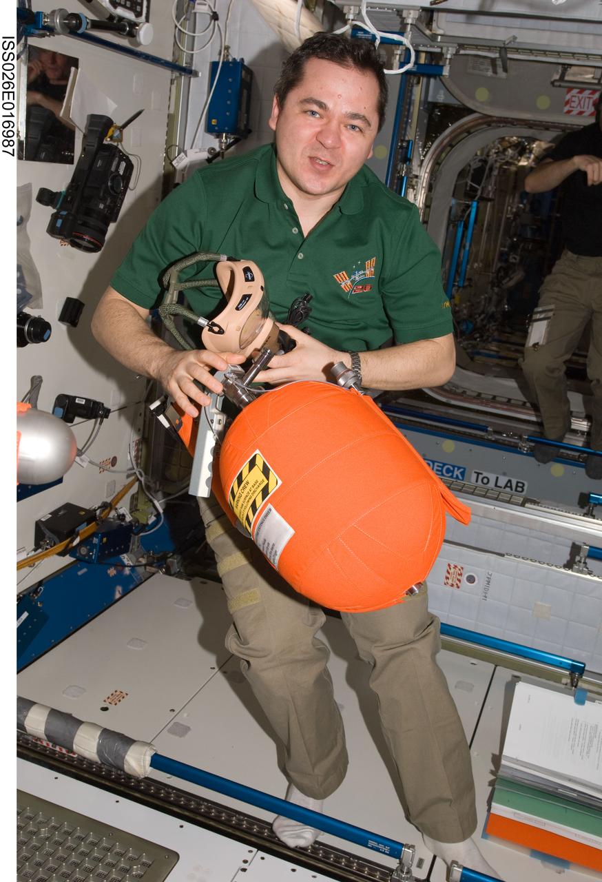
ISS026-E-016987 (11 Jan. 2011) --- Russian cosmonaut Oleg Skripochka, Expedition 26 flight engineer, participates in an emergency scenarios drill in the Harmony node of the International Space Station.
This head-on view shows the tip of the drill bit on NASA Mars rover Curiosity. The view merges two exposures taken by the remote micro-imager in the rover ChemCam instrument at different focus settings.
The shape of the tip of the bit in the drill of NASA Mars rover Curiosity is apparent in this view recorded by the remote micro-imager in the rover ChemCam instrument on Mars. Jan. 29, 2012; the bit is about 0.6 inch 1.6 centimeters wide.
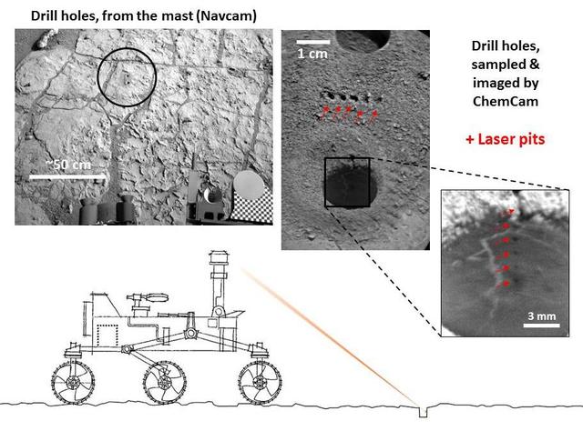
NASA Curiosity Mars rover targeted the laser of the ChemCam instrument with remarkable accuracy for assessing the composition of the wall of a drilled hole and tailings that resulted from the drilling.
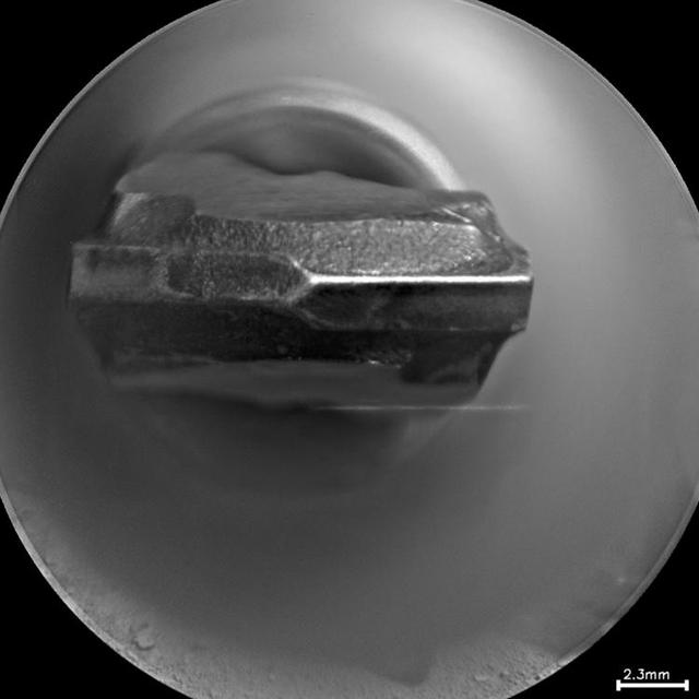
This image taken by the Mastcam-Z camera aboard NASA's Perseverance rover on Sept. 4, 2021, confirmed that the rover had retained a rock core in the sample tube held in the drill at the end of its robotic arm. After Perseverance drilled the hole called "Montdenier" in the rock nicknamed "Rochette" on Sept. 1 and acquired the rock core, which is slightly thicker than a pencil, the rover vibrated it to clear any material stuck between the coring bit and the sample tube within the bit. The rover then conducted additional imaging to double-check that it retained the rock. This image has been processed to enhance contrast. A key objective for Perseverance's mission on Mars is astrobiology, including the search for signs of ancient microbial life. The rover will characterize the planet's geology and past climate, pave the way for human exploration of the Red Planet, and be the first mission to collect and cache Martian rock and regolith. The Mars 2020 Perseverance mission is part of NASA's Moon to Mars exploration approach, which includes Artemis missions to the Moon that will help prepare for human exploration of the Red Planet. Subsequent NASA missions, in cooperation with ESA (European Space Agency), would send spacecraft to Mars to collect these sealed samples from the surface and return them to Earth for in-depth analysis. https://photojournal.jpl.nasa.gov/catalog/PIA24832
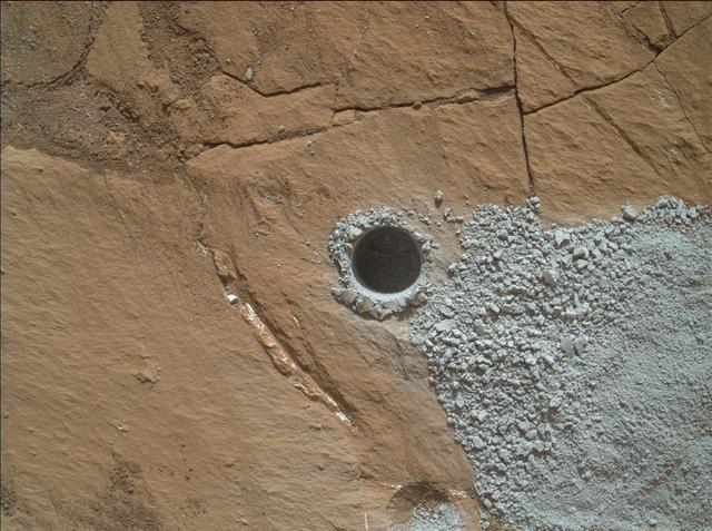
NASA's Curiosity Mars Rover drilled this hole to collect sample material from a rock target called "Buckskin" on July 30, 2015, during the 1060th Martian day, or sol, of the rover's work on Mars. The diameter is slightly smaller than a U.S. dime. Curiosity landed on Mars on Aug. 6, 2012, Universal Time (evening of Aug. 5, PDT). The rover took this image with the Mars Hand Lens Imager (MAHLI) camera, which is mounted on the same robotic arm as the sample-collecting drill. Rock powder from the collected sample was subsequently delivered to a laboratory inside the rover for analysis. The rover's drill did not experience any sign during this sample collection of an intermittent short-circuiting issue that was detected earlier in 2015. The Buckskin target is in an area near "Marias Pass" on lower Mount Sharp where Curiosity had detected unusually high levels of silica and hydrogen. MAHLI was built by Malin Space Science Systems, San Diego. NASA's Jet Propulsion Laboratory, a division of the California Institute of Technology in Pasadena, manages the Mars Science Laboratory Project for the NASA Science Mission Directorate, Washington. JPL designed and built the project's Curiosity rover. http://photojournal.jpl.nasa.gov/catalog/PIA19804
ISS043E019025 (03/18/2015) --- Safety training never ends onboard the International Space Station. This photo in the U.S. Laboratory on Mar. 18, 2015 was taken during Emergency Egress Drill On-Board Training (OBT) with the Expedition 43 crew. Russian cosmonaut Mikhail Kornienko (rear) and ESA (European Space Agency) astronaut Samantha Cristoforetti (middle), both flight engineers, are shown with astronaut Terry Virts, Commander (front) during the important emergency drill.
NASA's Curiosity Mars rover used its Mast Camera, or Mastcam, to take this 360-degree panorama of at the "Avanavero" drill site. The panorama is made up of 127 individual images taken on June 20, 2022, the 3,509th Martian day, or sol, of the mission, and stitched together back on Earth. The color has been adjusted to match the lighting conditions as the human eye would perceive them on Earth. At this location, Curiosity used the drill on its robotic arm to collect a rock sample for analysis by laboratory instruments inside the vehicle. It has collected more than three dozen such samples in its decade on the Red Planet. In the center of the panorama is a gap between two hills – nicknamed "Paraitepuy Pass" – that Curiosity is currently driving through; beyond it is a layered sulfate-bearing region, which represents a drier, saltier era in the history of Mount Sharp, the 3-mile-tall (5-kilometer-tall) mountain the rover has been ascending since 2014. https://photojournal.jpl.nasa.gov/catalog/PIA25407

This self-portrait of NASA's Curiosity Mars rover shows the vehicle at the "Big Sky" site, where its drill collected the mission's fifth taste of Mount Sharp. The scene combines dozens of images taken during the 1,126th Martian day, or sol, of Curiosity's work during Mars (Oct. 6, 2015, PDT), by the Mars Hand Lens Imager (MAHLI) camera at the end of the rover's robotic arm. The rock drilled at this site is sandstone in the Stimson geological unit inside Gale Crater. The location is on cross-bedded sandstone in which the cross bedding is more evident in views from when the rover was approaching the area, such as PIA19818. The view is centered toward the west-northwest. It does not include the rover's robotic arm, though the shadow of the arm is visible on the ground. Wrist motions and turret rotations on the arm allowed MAHLI to acquire the mosaic's component images. The arm was positioned out of the shot in the images, or portions of images, that were used in this mosaic. This process was used previously in acquiring and assembling Curiosity self-portraits taken at sample-collection sites "Rocknest" (PIA16468), "John Klein" (PIA16937) and "Windjana" (PIA18390). This portrait of the rover was designed to show the Chemistry and Camera (ChemCam) instrument atop the rover appearing level. This causes the horizon to appear to tilt toward the left, but in reality it is fairly flat. For scale, the rover's wheels are 20 inches (50 centimeters) in diameter and about 16 inches (40 centimeters) wide. The drilled hole in the rock, appearing grey near the lower left corner of the image, is 0.63 inch (1.6 centimeters) in diameter. MAHLI was built by Malin Space Science Systems, San Diego. NASA's Jet Propulsion Laboratory, a division of the California Institute of Technology in Pasadena, manages the Mars Science Laboratory Project for the NASA Science Mission Directorate, Washington. JPL designed and built the project's Curiosity rover. http://photojournal.jpl.nasa.gov/catalog/PIA19920
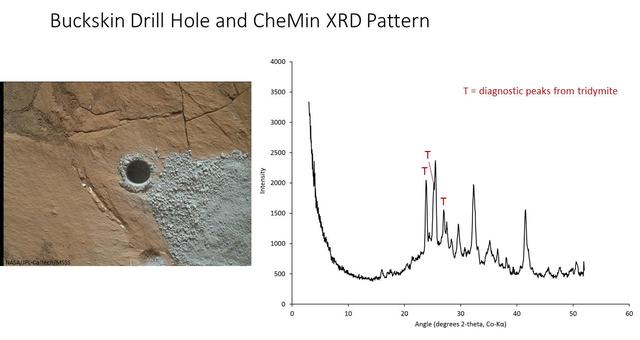
The graph at right presents information from the NASA Curiosity Mars rover's onboard analysis of rock powder drilled from the "Buckskin" target location, shown at left. X-ray diffraction analysis of the Buckskin sample inside the rover's Chemistry and Mineralogy (CheMin) instrument revealed the presence of a silica-containing mineral named tridymite. This is the first detection of tridymite on Mars. Peaks in the X-ray diffraction pattern are from minerals in the sample, and every mineral has a diagnostic set of peaks that allows identification. The image of Buckskin at left was taken by the rover's Mars Hand Lens Imager (MAHLI) camera on July 30, 2015, and is also available at PIA19804. http://photojournal.jpl.nasa.gov/catalog/PIA20271

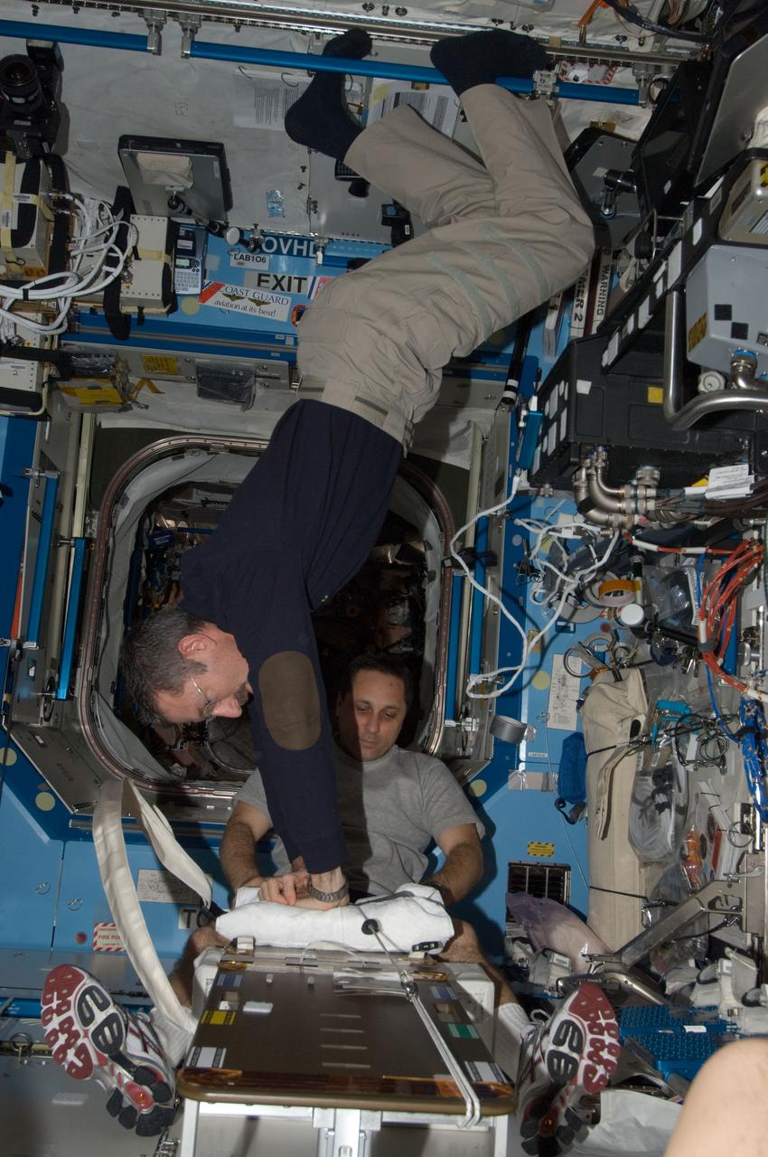
ISS038-E-011718 (4 Dec. 2013) --- The Expedition 38 crew members participate in an emergency simulation drill with participation from flight controllers on the ground. During the exercise, the crew practiced emergency communication and procedures in response to a predetermined scenario such as pressure leak. Pictured in the International Space Station?s Destiny laboratory are Russian cosmonaut Oleg Kotov (center), commander; NASA astronaut Michael Hopkins (left), Japan Aerospace Exploration Agency astronaut Koichi Wakata, flight engineers.
This selfie was taken by NASA's Curiosity Mars rover on Feb. 26, 2020 (the 2,687th Martian day, or sol, of the mission). The crumbling rock layer at the top of the image is the Greenheugh Pediment, which Curiosity climbed soon after taking the image. Directly to the left of Curiosity's foremost wheel is a hole the rover drilled at a rock feature called "Hutton." The selfie includes 86 individual images taken by the Mars Hand Lens Imager (MAHLI) camera on the end of Curiosity's robotic arm. The images were then stitched into a panorama. https://photojournal.jpl.nasa.gov/catalog/PIA23624
ISS038-E-011708 (4 Dec. 2013) --- In the International Space Station?s Zvezda Service Module, Russian cosmonaut Sergey Ryazanskiy, Expedition 38 flight engineer, reads a procedures checklist during an emergency simulation drill with participation from flight controllers on the ground. During the exercise, the crew practiced emergency communication and procedures in response to a predetermined scenario such as pressure leak.
ISS038-E-011710 (4 Dec. 2013) --- In the International Space Station’s Destiny laboratory, NASA astronaut Michael Hopkins (foreground) and Japan Aerospace Exploration Agency astronaut Koichi Wakata, both Expedition 38 flight engineers, participate in an emergency simulation drill with participation from flight controllers on the ground. During the exercise, the crew practiced emergency communication and procedures in response to a predetermined scenario such as pressure leak.
ISS038-E-011716 (4 Dec. 2013) --- The Expedition 38 crew members participate in an emergency simulation drill with participation from flight controllers on the ground. During the exercise, the crew practiced emergency communication and procedures in response to a predetermined scenario such as pressure leak. Pictured in the International Space Station?s Destiny laboratory are Russian cosmonaut Oleg Kotov (left), commander; NASA astronaut Michael Hopkins (bottom), Japan Aerospace Exploration Agency astronaut Koichi Wakata (center) and Russian cosmonaut Sergey Ryazanskiy, all flight engineers.
This image from the Navigation Camera Navcam on NASA Curiosity Mars rover shows two holes at top center drilled into a sandstone target called Windjana. The farther hole, with larger pile of tailings around it, is a full-depth sampling hole.
ISS034-E-005260 (26 Nov. 2012) --- Russian cosmonaut Oleg Novitskiy, Expedition 34 flight engineer, participates in a Crew Health Care System (CHeCS) medical contingency drill in the Destiny laboratory of the International Space Station. This drill gives crew members the opportunity to work as a team in resolving a simulated medical emergency onboard the space station.
ISS030-E-012600 (16 Dec. 2011) --- Russian cosmonaut Anton Shkaplerov, Expedition 30 flight engineer, participates in a Crew Health Care System (CHeCS) medical contingency drill in the Destiny laboratory of the International Space Station. This drill gives crew members the opportunity to work as a team in resolving a simulated medical emergency onboard the space station.
ISS030-E-012604 (16 Dec. 2011) --- Russian cosmonauts Anatoly Ivanishin (foreground) and Anton Shkaplerov, both Expedition 30 flight engineers, participate in a Crew Health Care System (CHeCS) medical contingency drill in the Destiny laboratory of the International Space Station. This drill gives crew members the opportunity to work as a team in resolving a simulated medical emergency onboard the space station.
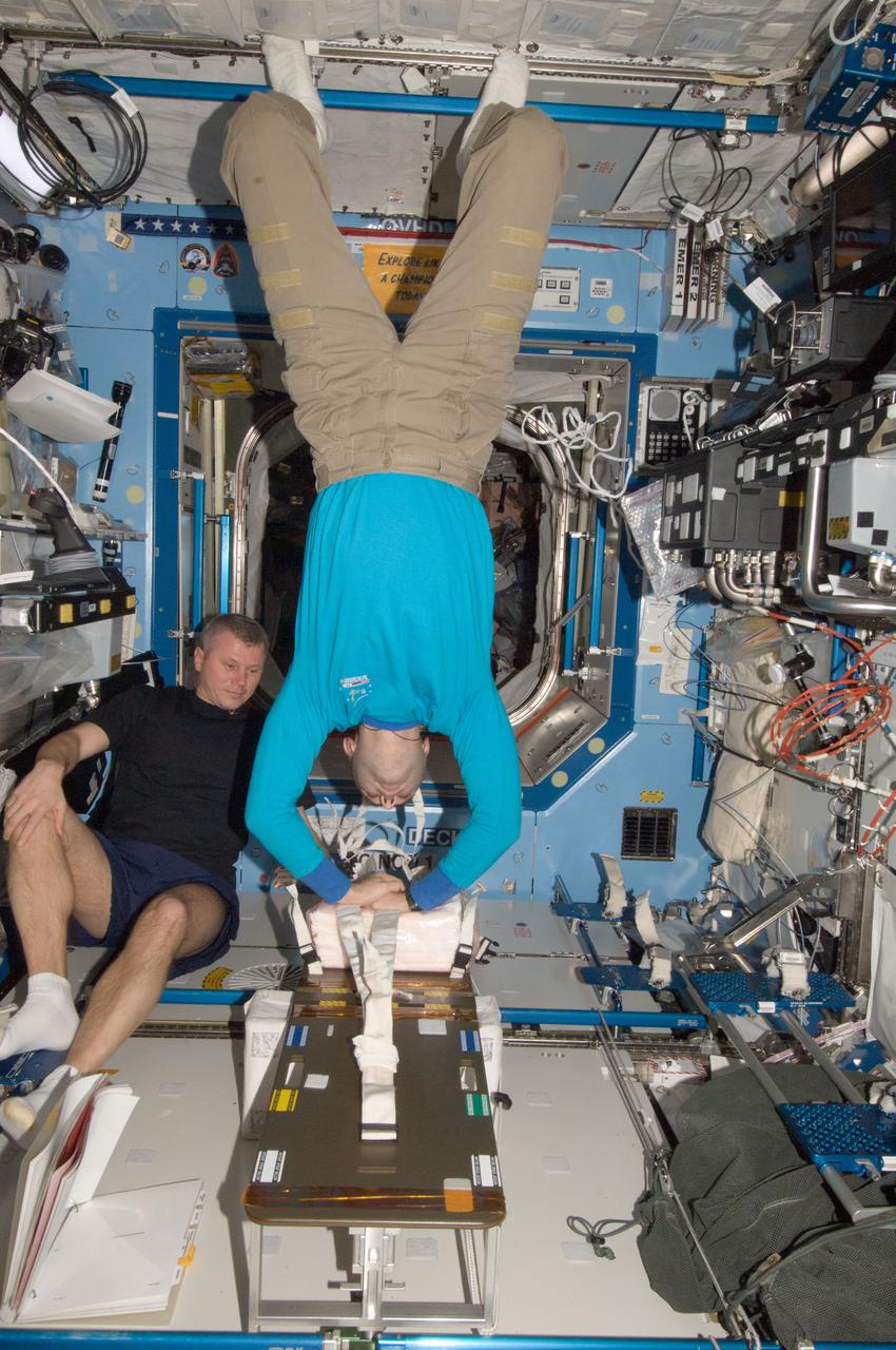
ISS034-E-005261 (26 Nov. 2012) --- Russian cosmonauts Oleg Novitskiy (left) and Evgeny Tarelkin, both Expedition 34 flight engineers, participate in a Crew Health Care System (CHeCS) medical contingency drill in the Destiny laboratory of the International Space Station. This drill gives crew members the opportunity to work as a team in resolving a simulated medical emergency onboard the space station.
ISS030-E-012613 (16 Dec. 2011) --- NASA astronaut Dan Burbank (foreground), Expedition 30 commander, and Russian cosmonaut Anton Shkaplerov, flight engineer, participate in a Crew Health Care System (CHeCS) medical contingency drill in the Destiny laboratory of the International Space Station. This drill gives crew members the opportunity to work as a team in resolving a simulated medical emergency onboard the space station.