
This montage shows changing faces of the Sun, recorded daily during the 59 days spent in orbit by Skylab's second crew. The Sun spun more than two full turns around its axis. Solar rotation is apparent in these daily portraits, as are real changes on the Sun. Bright features are centers of activity on the Sun. This image contains daily records from August 17, 1973 through September 5, 1973.
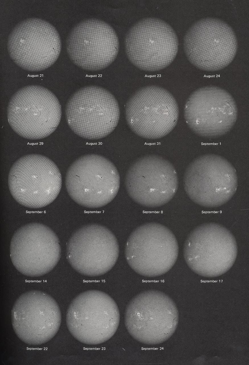
This montage shows changing faces of the Sun, recorded daily during the 59 days spent in orbit by Skylab's second crew. The Sun spun more than two full turns around its axis. Solar rotation is apparent in these daily portraits, as are real changes on the Sun. Bright features are centers of activity on the Sun. This image contains daily records from September 6, 1973 through September 24, 1973.
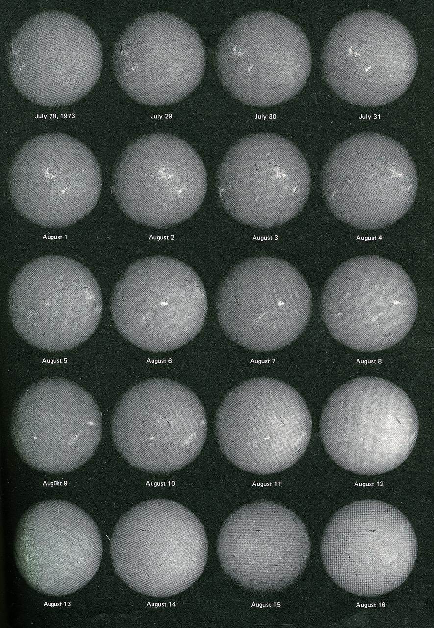
This montage shows changing faces of the Sun, recorded daily during the 59 days spent in orbit by Skylab's second crew. The Sun spun more than two full turns around its axis. Solar rotation is apparent in these daily portraits, as are real changes on the Sun. Bright features are centers of activity on the Sun. This image contains daily records from July 28, 1973 through August 16, 1973.
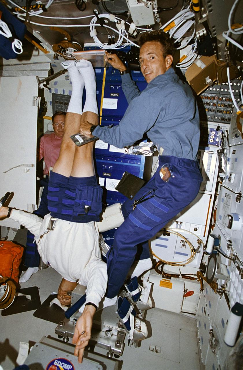
STS064-05-020 (9-20 Sept. 1994) --- Astronaut Mark C. Lee gets his height measured by astronaut Jerry M. Linenger as part of a daily in-flight routine supporting a medical Detailed Supplementary Objective (DSO). Astronaut Richard N. Richards, STS-64 mission commander, looks on in the background. This study was designed to collect information about back pain and height changes experienced by astronauts during flight. Crew members participating in this DSO are required to record height measurements and long back-pain symptoms daily. As an ongoing program, this DSO will gather data from 30 astronauts who spend more than eight consecutive days in space. Photo credit: NASA or National Aeronautics and Space Administration
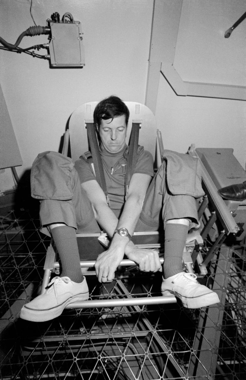
S73-20622 (March 1973) --- Scientist-astronaut Joseph P. Kerwin, science pilot of the first manned Skylab mission, demonstrates the Body Mass Measurement Experiment (M172) during Skylab training at the Johnson Space Center. Dr. Kerwin is in the work and experiments area of the crew quarters of the Skylab Orbital Workshop (OWS) trainer at JSC. The M172 experiment will demonstrate body mass measurement in a null gravity environment, validate theoretical behavior of this method, and support those medical experiments for which body mass measurements are required. The data to be collected in support of M172 are: preflight calibration of the body mass measurement device and measurements of known masses up to 100 kilograms (220 pounds) three times during each Skylab mission. The device, a spring/flexure pivot-mounted chair, will also be used for daily determination of the crewmen?s weight, which will be manually logged and voice recorded for subsequent telemetered transmission. Photo credit: NASA
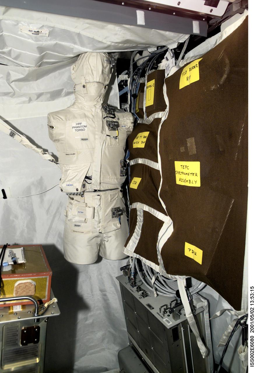
ISS002-E-6080 (2 May 2001) --- The Phantom Torso, seen here in the Human Research Facility (HRF) section of the Destiny/U.S. laboratory on the International Space Station (ISS), is designed to measure the effects of radiation on organs inside the body by using a torso that is similar to those used to train radiologists on Earth. The torso is equivalent in height and weight to an average adult male. It contains radiation detectors that will measure, in real-time, how much radiation the brain, thyroid, stomach, colon, and heart and lung area receive on a daily basis. The data will be used to determine how the body reacts to and shields its internal organs from radiation, which will be important for longer duration space flights. The experiment was delivered to the orbiting outpost during by the STS-100/6A crew in April 2001. Dr. Gautam Badhwar, NASA JSC, Houston, TX, is the principal investigator for this experiment. A digital still camera was used to record this image.

This artist's concept represents the "Follow the Water" theme of NASA's Mars Reconnaissance Orbiter mission. The orbiter's science instruments monitor the present water cycle in the Mars atmosphere and the associated deposition and sublimation of water ice on the surface, while probing the subsurface to see how deep the water-ice reservoir detected by Mars Odyssey extends. At the same time, Mars Reconnaissance Orbiter will search for surface features and minerals (such as carbonates and sulfates) that record the extended presence of liquid water on the surface earlier in the planet's history. The instruments involved are the Shallow Subsurface Radar, the Compact Reconnaissance Imaging Spectrometer for Mars, the Mars Color Imager, the High Resolution Imaging Science Experiment, the Context Camera and the Mars Climate Sounder. To the far left, the radar antenna beams down and "sees" into the first few hundred feet (up to 1 kilometer) of Mars' crust. Just to the right of that, the next beam highlights the data received from the imaging spectrometer, which identifies minerals on the surface. The next beam represents the high-resolution camera, which can "zoom in" on local targets, providing the highest-resolution orbital images yet of features such as craters and gullies and rocks. The beam that shines almost horizontally is that of the Mars Climate Sounder. This instrument is critical to analyzing the current climate of Mars since it observes the temperature, humidity, and dust content of the martian atmosphere, and their seasonal and year-to-year variations. Meanwhile, the Mars Color Imager observes ice clouds, dust clouds and hazes, and the ozone distribution, producing daily global maps in multiple colors to monitor daily weather and seasonal changes. The electromagnetic spectrum is represented on the top right and individual instruments are placed where their capability lies. http://photojournal.jpl.nasa.gov/catalog/PIA07241
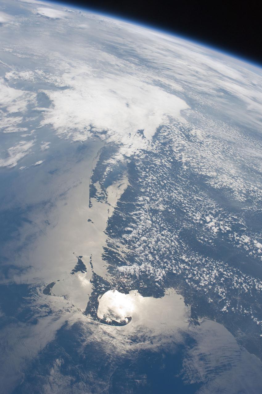
ISS028-E-009979 (27 June 2011) --- The Massachusetts coastline is featured in this image photographed by an Expedition 28 crew member on the International Space Station. The Crew Earth Observations team at NASA Johnson Space Center sends specific ground targets for photography up to the station crew on a daily basis, but sometimes the crew takes imagery on their own of striking displays visible from orbit. One such display, often visible to the ISS crew due to their ability to look outwards at angles between 0 and 90 degrees, is sunglint on the waters of Earth. Sunglint is caused by sunlight reflecting off of a water surface?much as light reflects from a mirror?directly towards the observer. Roughness variations of the water surface scatter the light, blurring the reflection and producing the typical silvery sheen of the sunglint area. The point of maximum sunglint is centered within Cape Cod Bay, the body of water partially enclosed by the ?hook? of Cape Cod in Massachusetts (bottom). Cape Cod was formally designated a National Seashore in 1966. Sunglint off the water provides sharp contrast with the coastline and the nearby islands of Martha?s Vineyard and Nantucket (lower left), both popular destinations for tourists and summer residents. To the north, rocky Cape Ann extends out into the Atlantic Ocean; the border with New Hampshire is located approximately 30 kilometers up the coast. Further to the west, the eastern half of Long Island, New York is visible emerging from extensive cloud cover over the mid-Atlantic and Midwestern States. Persistent storm tracks had been contributing to record flooding along rivers in the Midwest at the time this image was taken in late June 2011. Thin blue layers of the atmosphere, contrasted against the darkness of space, are visible extending along the Earth?s curvature at top.
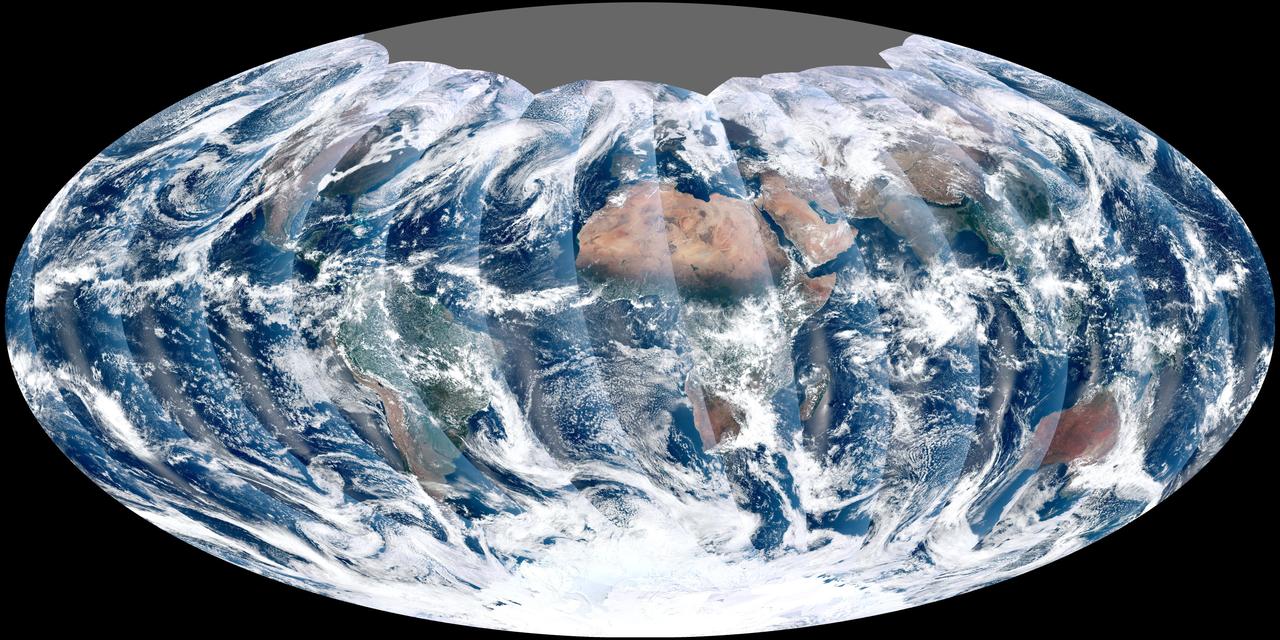
NASA acquired November 24, 2011 From its vantage 824 kilometers (512 miles) above Earth, the Visible Infrared Imager Radiometer Suite (VIIRS) on the NPOESS Preparatory Project (NPP) satellite gets a complete view of our planet every day. This image from November 24, 2011, is the first complete global image from VIIRS. The NPP satellite launched on October 28, 2011, and VIIRS acquired its first measurements on November 21. To date, the images are preliminary, used to gauge the health of the sensor as engineers continue to power it up for full operation. Rising from the south and setting in the north on the daylight side of Earth, VIIRS images the surface in long wedges measuring 3,000 kilometers (1,900 miles) across. The swaths from each successive orbit overlap one another, so that at the end of the day, the sensor has a complete view of the globe. The Arctic is missing because it is too dark to view in visible light during the winter. The NPP satellite was placed in a Sun-synchronous orbit, a unique path that takes the satellite over the equator at the same local (ground) time in every orbit. So, when NPP flies over Kenya, it is about 1:30 p.m. on the ground. When NPP reaches Gabon—about 3,000 kilometers to the west—on the next orbit, it is close to 1:30 p.m. on the ground. This orbit allows the satellite to maintain the same angle between the Earth and the Sun so that all images have similar lighting. The consistent lighting is evident in the daily global image. Stripes of sunlight (sunglint) reflect off the ocean in the same place on the left side of every swath. The consistent angle is important because it allows scientists to compare images from year to year without worrying about extreme changes in shadows and lighting. The image also shows a band of haze along the right side of every orbit swath. When light travels through the atmosphere, it bounces off particles or scatters, making the atmosphere look hazy. The scattering effect is most pronounced along the edge of the swath, where the sensor is looking at an angle through more of the atmosphere. Scientists can correct for this scattering effect, but need measurements from a range of wavelengths to do so. The degree to which light scatters depends partly on the wavelength of the light. Blue light scatters more than red light, for example, which is why the sky is blue. VIIRS measures 22 different wavelengths of light, but not all of the sensor’s detectors are operating at peak performance yet. Those measuring thermal infrared light are not yet cold enough to collect reliable measurements. Once VIIRS begins full operations, it will produce a range of measurements from ocean temperature to clouds to the locations of fires. These measurements will help extend the record from earlier sensors like the Moderate Resolution Imaging Spectroradiometer (MODIS). VIIRS is very similar to MODIS, but flies at a higher altitude to measure the whole planet without gaps. (MODIS daily measurements have gaps at the equator. See the MODIS image from November 24.) VIIRS also sees the Earth in less detail, 375 meters per pixel, compared to 250 meters per pixel for MODIS. Image by NASA’s NPP Land Product Evaluation and Testing Element. Caption by Holli Riebeek. Credit: <b><a href="http://www.earthobservatory.nasa.gov/" rel="nofollow"> NASA Earth Observatory</a></b> <b><a href="http://www.nasa.gov/audience/formedia/features/MP_Photo_Guidelines.html" rel="nofollow">NASA image use policy.</a></b> <b><a href="http://www.nasa.gov/centers/goddard/home/index.html" rel="nofollow">NASA Goddard Space Flight Center</a></b> enables NASA’s mission through four scientific endeavors: Earth Science, Heliophysics, Solar System Exploration, and Astrophysics. Goddard plays a leading role in NASA’s accomplishments by contributing compelling scientific knowledge to advance the Agency’s mission. <b>Follow us on <a href="http://twitter.com/NASA_GoddardPix" rel="nofollow">Twitter</a></b> <b>Like us on <a href="http://www.facebook.com/pages/Greenbelt-MD/NASA-Goddard/395013845897?ref=tsd" rel="nofollow">Facebook</a></b> <b>Find us on <a href="http://instagrid.me/nasagoddard/?vm=grid" rel="nofollow">Instagram</a></b>