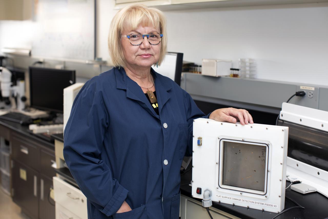
Martha Williams, who leads the team inventing the Flexible Damage Detection System, stands in a laboratory with a prototype at NASA's Kennedy Space Center in Florida. The system uses circuits printed on thin thermal film and specialized software. The system is designed to show where damage to a surface occurs and how severe it may be. It could offer astronauts a real-time update on their spacecraft's condition during a mission without requiring a spacewalk.

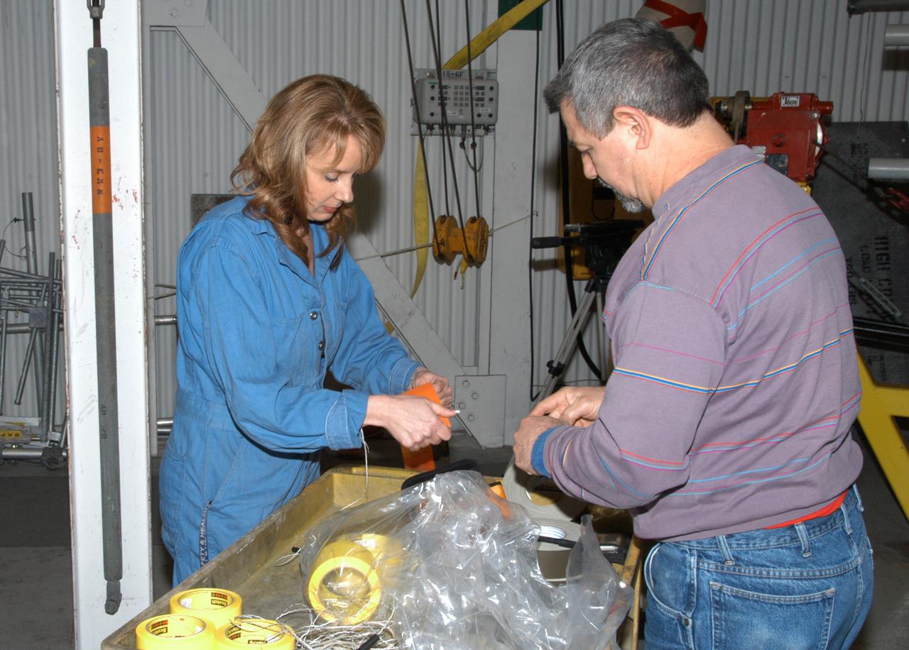
Jamie Szafran, from left, Mark Lewis and Curtis Ihlefeld work with the prototype of the Flexible Damage Detection System in a laboratory with a prototype at NASA's Kennedy Space Center in Florida. The system uses circuits printed on thin thermal film and specialized software. The system is designed to show where damage to a surface occurs and how severe it may be. It could offer astronauts a real-time update on their spacecraft's condition during a mission without requiring a spacewalk.
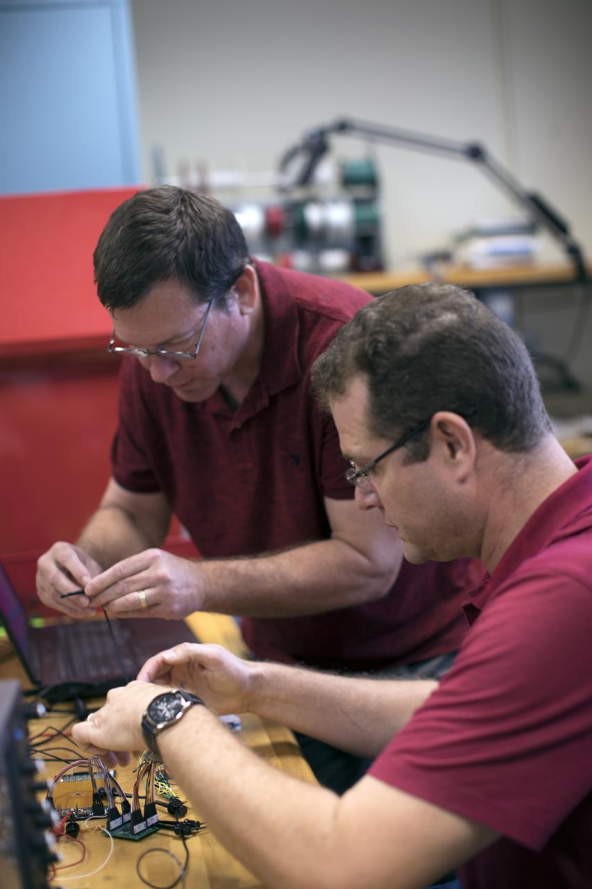
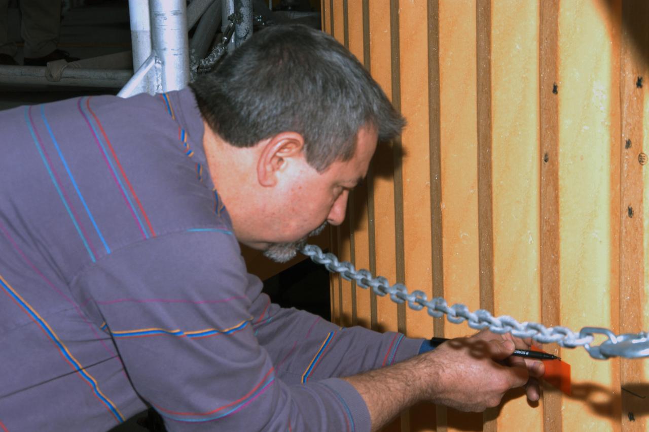
Curtis Ihlefeld, left, and Mark Lewis work with the prototype of the Flexible Damage Detection System in a laboratory with a prototype at NASA's Kennedy Space Center in Florida. The system uses circuits printed on thin thermal film and specialized software. The system is designed to show where damage to a surface occurs and how severe it may be. It could offer astronauts a real-time update on their spacecraft's condition during a mission without requiring a spacewalk.
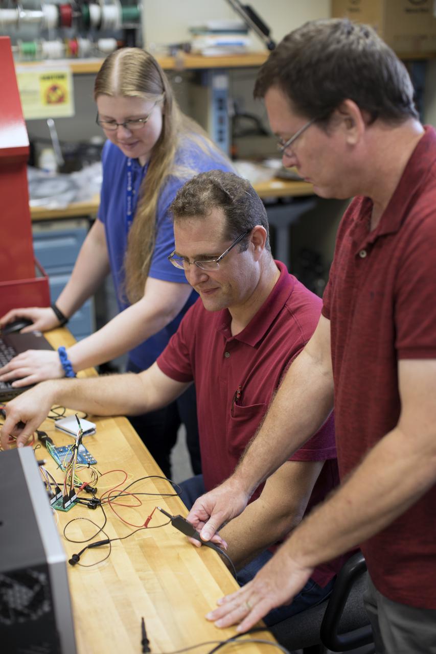
Jamie Szafran, from left, Mark Lewis and Curtis Ihlefeld work with the prototype of the Flexible Damage Detection System in a laboratory with a prototype at NASA's Kennedy Space Center in Florida. The system uses circuits printed on thin thermal film and specialized software. The system is designed to show where damage to a surface occurs and how severe it may be. It could offer astronauts a real-time update on their spacecraft's condition during a mission without requiring a spacewalk.
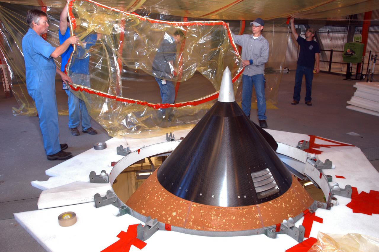
On an upper level of high bay 1 of the Vehicle Assembly Building, technicians move protective material toward the nose cone (foreground) of Atlantis' external tank. The nose cone will undergo repair for hail damage. A severe thunderstorm with golf ball-sized hail caused visible divots in the giant tank's foam insulation and minor surface damage to about 26 heat shield tiles on the shuttle's left wing. Further evaluation of the tank is necessary to get an accurate accounting of foam damage and determine the type of repair required and the time needed for that work. A new target launch date has not been determined, but teams will focus on preparing Atlantis for liftoff in late April on mission STS-117.
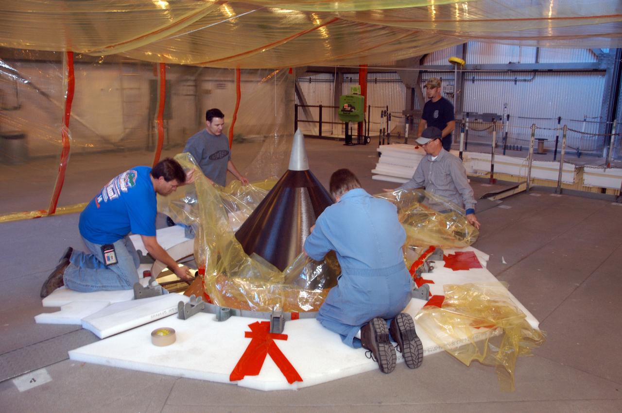
On an upper level of high bay 1 of the Vehicle Assembly Building, technicians place protective material around the nose cone of Atlantis' external tank. The nose cone will undergo repair for hail damage. A severe thunderstorm with golf ball-sized hail caused visible divots in the giant tank's foam insulation and minor surface damage to about 26 heat shield tiles on the shuttle's left wing. Further evaluation of the tank is necessary to get an accurate accounting of foam damage and determine the type of repair required and the time needed for that work. A new target launch date has not been determined, but teams will focus on preparing Atlantis for liftoff in late April on mission STS-117.
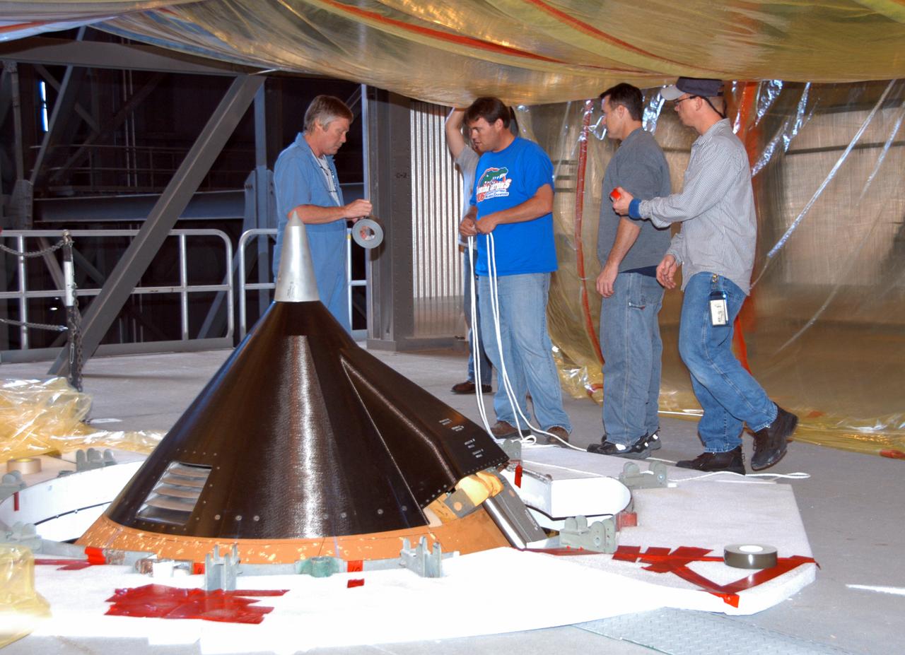
On an upper level of high bay 1 of the Vehicle Assembly Building, technicians prepare the area around the nose cone (left) of Atlantis' external tank that will undergo repair for hail damage. A severe thunderstorm with golf ball-sized hail caused visible divots in the giant tank's foam insulation and minor surface damage to about 26 heat shield tiles on the shuttle's left wing. Further evaluation of the tank is necessary to get an accurate accounting of foam damage and determine the type of repair required and the time needed for that work. A new target launch date has not been determined, but teams will focus on preparing Atlantis for liftoff in late April on mission STS-117.
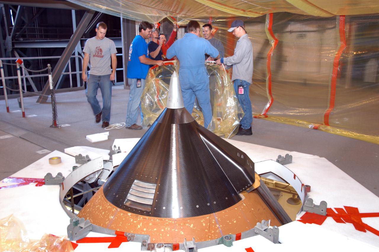
On an upper level of high bay 1 of the Vehicle Assembly Building, technicians prepare the area around the nose cone (foreground) of Atlantis' external tank that will undergo repair for hail damage. A severe thunderstorm with golf ball-sized hail caused visible divots in the giant tank's foam insulation and minor surface damage to about 26 heat shield tiles on the shuttle's left wing. Further evaluation of the tank is necessary to get an accurate accounting of foam damage and determine the type of repair required and the time needed for that work. A new target launch date has not been determined, but teams will focus on preparing Atlantis for liftoff in late April on mission STS-117.
On an upper level of high bay 1 of the Vehicle Assembly Building, technicians secure protective material around Atlantis' external tank. The preparations are for future repair work of the hail damage that happened Feb. 27. A severe thunderstorm with golf ball-sized hail caused visible divots in the giant tank's foam insulation and minor surface damage to about 26 heat shield tiles on the shuttle's left wing. Further evaluation of the tank is necessary to get an accurate accounting of foam damage and determine the type of repair required and the time needed for that work. A new target launch date has not been determined, but teams will focus on preparing Atlantis for liftoff in late April on mission STS-117.

On an upper level of high bay 1 of the Vehicle Assembly Building, technicians secure protective material around the base of the nose cone of Atlantis' external tank. The nose cone will undergo repair for hail damage. A severe thunderstorm with golf ball-sized hail caused visible divots in the giant tank's foam insulation and minor surface damage to about 26 heat shield tiles on the shuttle's left wing. Further evaluation of the tank is necessary to get an accurate accounting of foam damage and determine the type of repair required and the time needed for that work. A new target launch date has not been determined, but teams will focus on preparing Atlantis for liftoff in late April on mission STS-117.
He Will Not Be Permanently Damaged
Technicians in the Vehicle Assembly Building prepare materials that will be used during repair of the nose cone on Atlantis' external tank. A severe thunderstorm with golf ball-sized hail caused visible divots in the giant tank's foam insulation and minor surface damage to about 26 heat shield tiles on the shuttle's left wing. Further evaluation of the tank is necessary to get an accurate accounting of foam damage and determine the type of repair required and the time needed for that work. A new target launch date has not been determined, but teams will focus on preparing Atlantis for liftoff in late April on mission STS-117.
In high bay 1 of the Vehicle Assembly Building, a technician marks off an area for inspection on Atlantis' external tank. A severe thunderstorm with golf ball-sized hail caused visible divots in the giant tank's foam insulation and minor surface damage to about 26 heat shield tiles on the shuttle's left wing. Further evaluation of the tank is necessary to get an accurate accounting of foam damage and determine the type of repair required and the time needed for that work. A new target launch date has not been determined, but teams will focus on preparing Atlantis for liftoff in late April on mission STS-117.
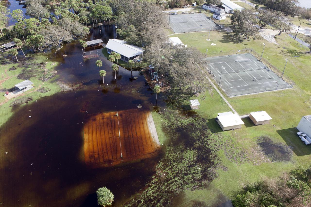
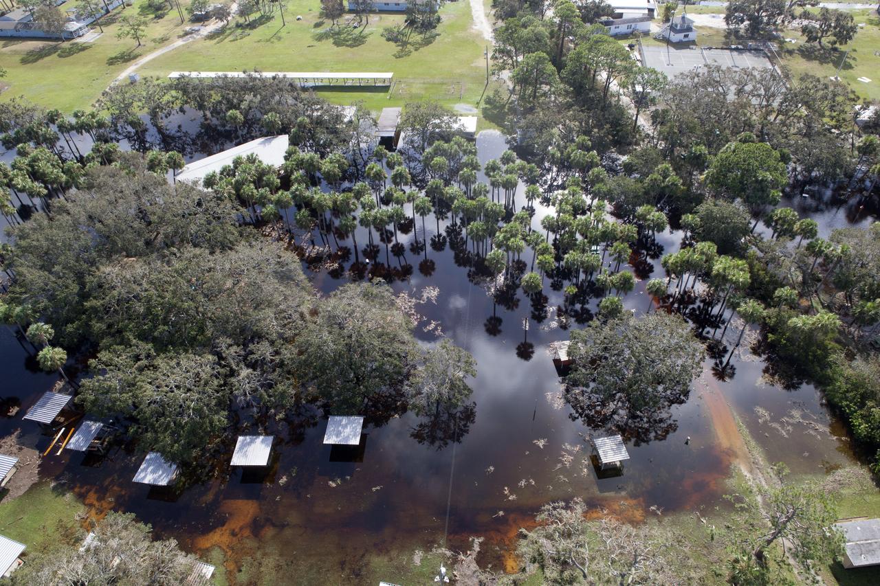
Damaged power lines are seen during an aerial survey of NASA's Kennedy Space Center in Florida on Saturday. The survey was performed to identify structures and facilities that may have sustained damage from Hurricane Matthew as the storm passed to the east of Kennedy on Oct. 6 and 7, 2016. Officials determined that the center received some isolated roof damage, damaged support buildings, a few downed power lines, and limited water intrusion. Beach erosion also occurred, although the storm surge was less than expected. NASA closed the center ahead of the storm’s onset and only a small team of specialists known as the Rideout Team was on the center as the storm approached and passed.
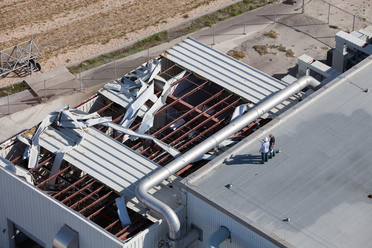
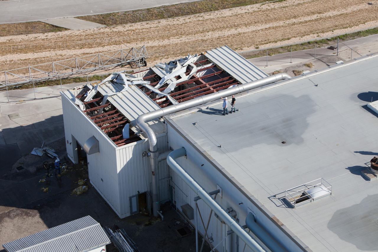
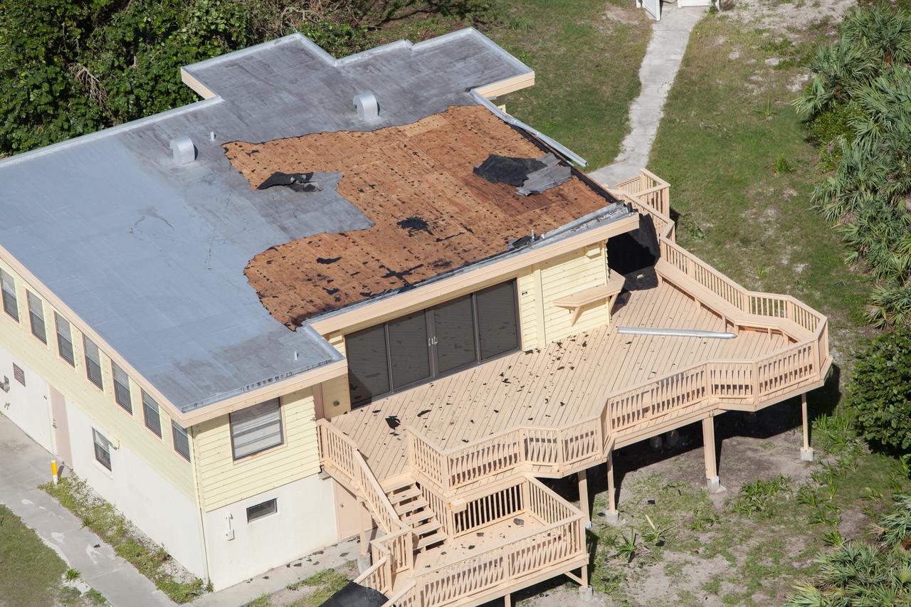
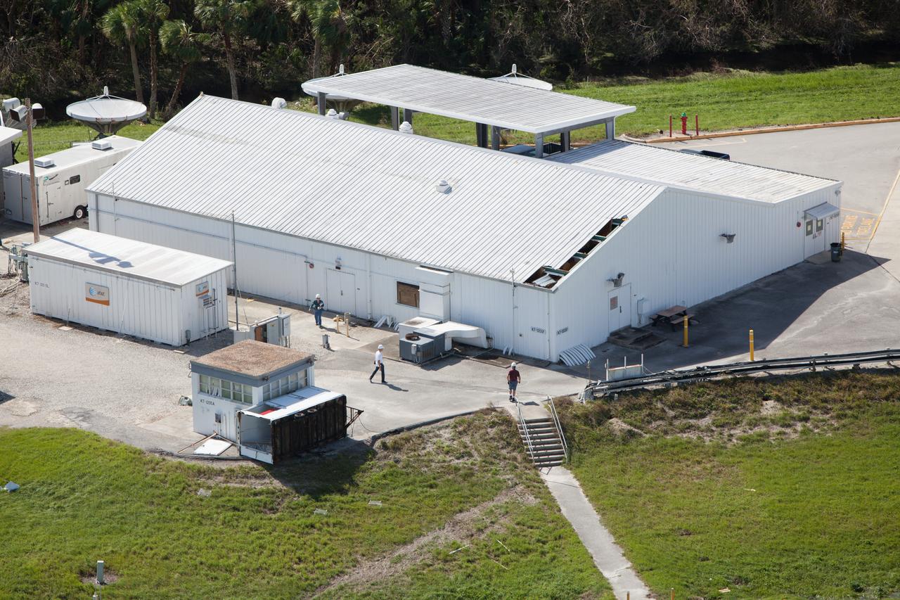
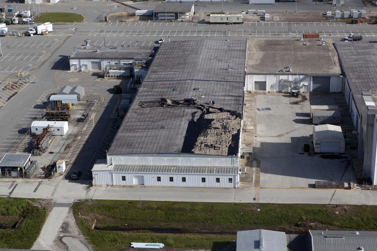
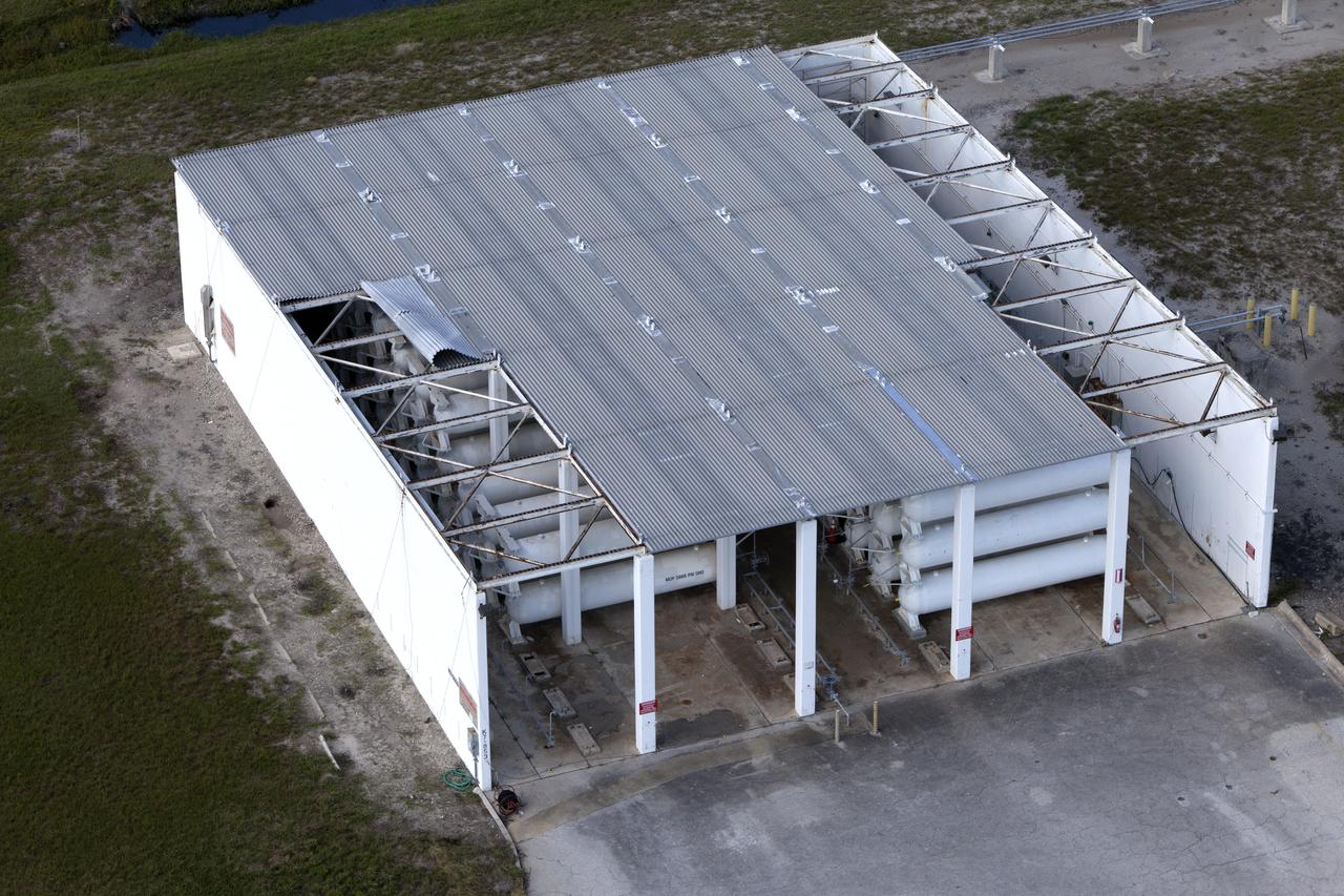
Damage to a facility roof is seen during an aerial survey of NASA's Kennedy Space Center in Florida on Saturday. The survey was performed to identify structures and facilities that may have sustained damage from Hurricane Matthew as the storm passed to the east of Kennedy on Oct. 6 and 7, 2016. Officials determined that the center received some isolated roof damage, damaged support buildings, a few downed power lines, and limited water intrusion. Beach erosion also occurred, although the storm surge was less than expected. NASA closed the center ahead of the storm’s onset and only a small team of specialists known as the Rideout Team was on the center as the storm approached and passed.
Damage to a facility roof is seen during an aerial survey of NASA's Kennedy Space Center in Florida on Saturday. The survey was performed to identify structures and facilities that may have sustained damage from Hurricane Matthew as the storm passed to the east of Kennedy on Oct. 6 and 7, 2016. Officials determined that the center received some isolated roof damage, damaged support buildings, a few downed power lines, and limited water intrusion. Beach erosion also occurred, although the storm surge was less than expected. NASA closed the center ahead of the storm’s onset and only a small team of specialists known as the Rideout Team was on the center as the storm approached and passed
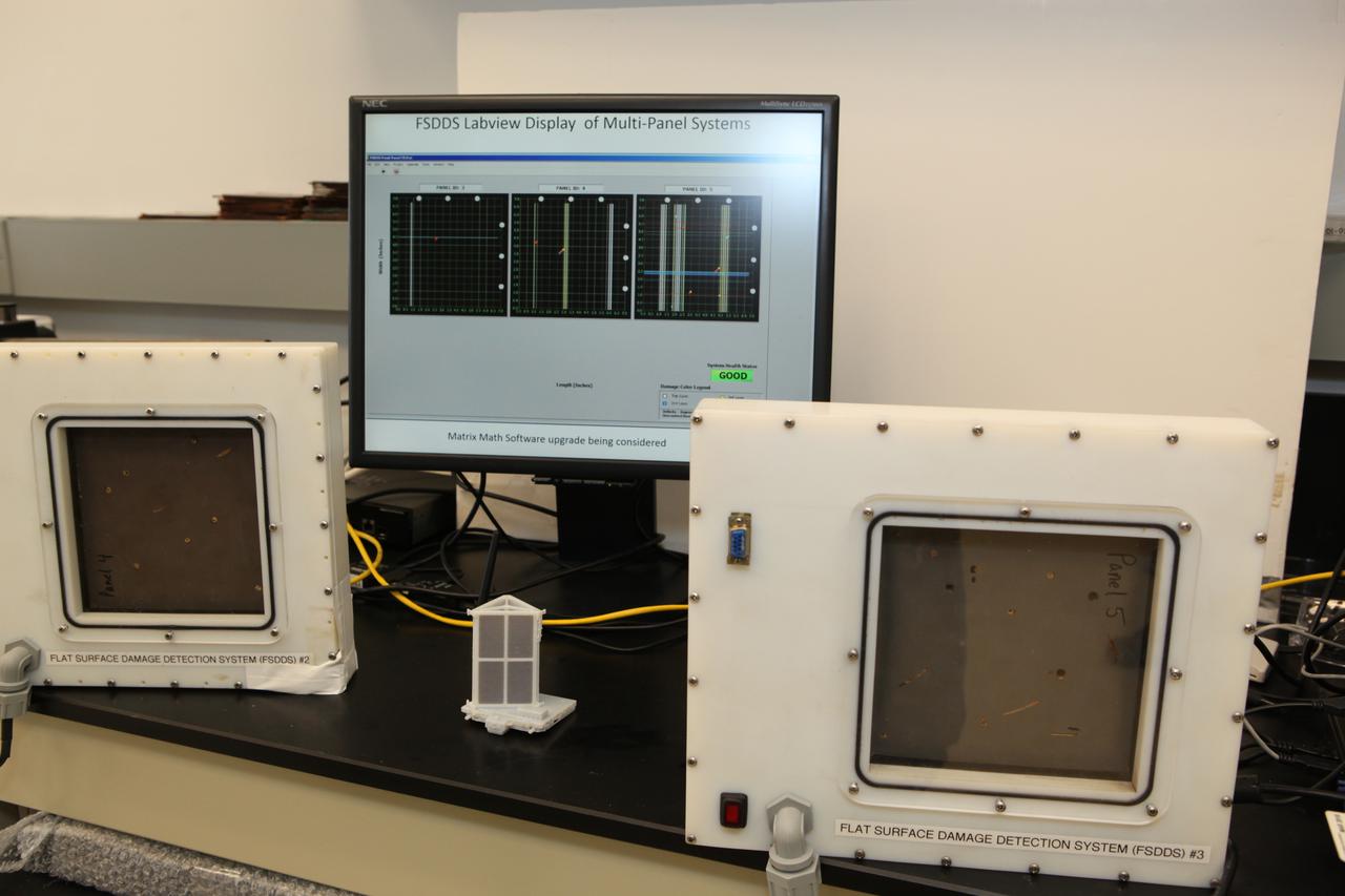
The complete prototype Flexible Damage Detection System stands in a laboratory at NASA's Kennedy Space Center in Florida. The system uses circuits printed on thin thermal film and specialized software. The system is designed to show where damage to a surface occurs and how severe it may be. It could offer astronauts a real-time update on their spacecraft's condition during a mission without requiring a spacewalk. Photo credit: NASA/Dimitri Gerondidakis
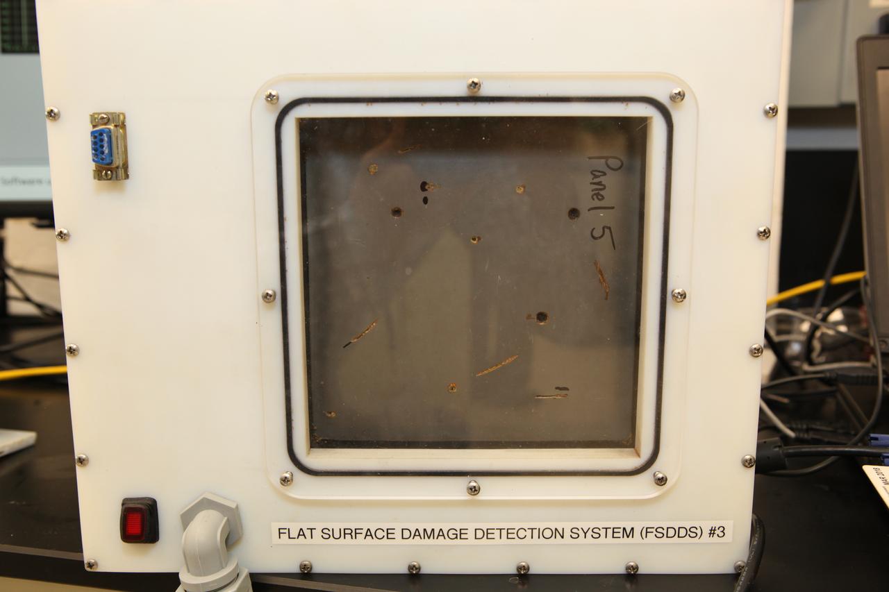
The prototype Flexible Damage Detection System stands in a laboratory at NASA's Kennedy Space Center in Florida. The system uses circuits printed on thin thermal film and specialized software. The system is designed to show where damage to a surface occurs and how severe it may be. It could offer astronauts a real-time update on their spacecraft's condition during a mission without requiring a spacewalk.
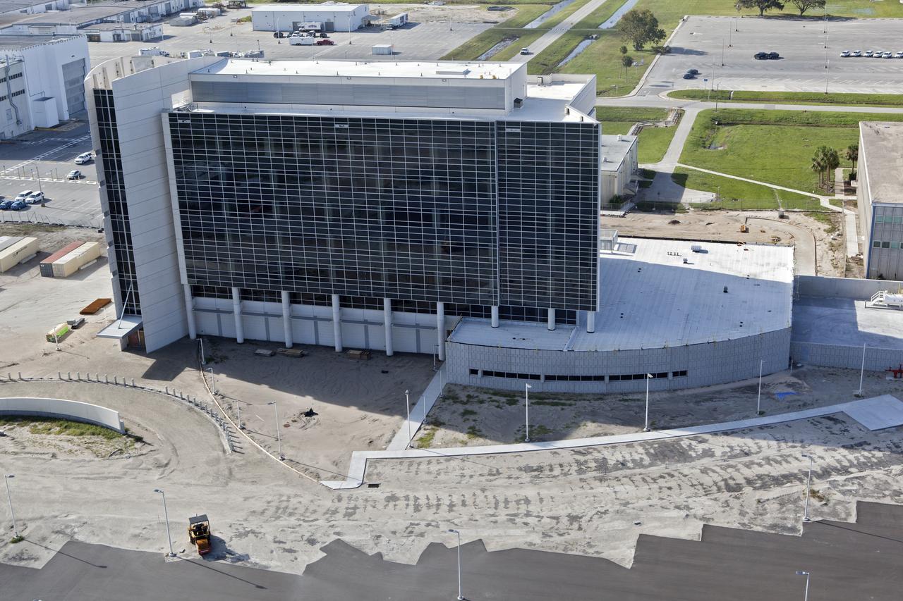
The Central Campus construction site is seen during an aerial survey of NASA's Kennedy Space Center in Florida on September 12, 2017. The survey was performed to identify structures and facilities that may have sustained damage from Hurricane Irma as the storm passed Kennedy on September 10, 2017. NASA closed the center ahead of the storm’s onset and only a small team of specialists known as the Rideout Team was on the center as the storm approached and passed.
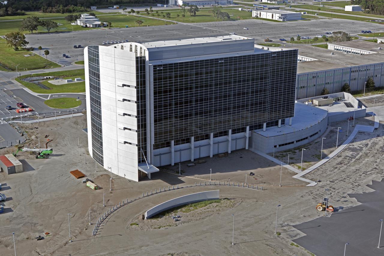
The Central Campus construction site is seen during an aerial survey of NASA's Kennedy Space Center in Florida on September 12, 2017. The survey was performed to identify structures and facilities that may have sustained damage from Hurricane Irma as the storm passed Kennedy on September 10, 2017. NASA closed the center ahead of the storm’s onset and only a small team of specialists known as the Rideout Team was on the center as the storm approached and passed.

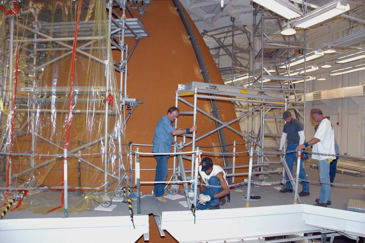
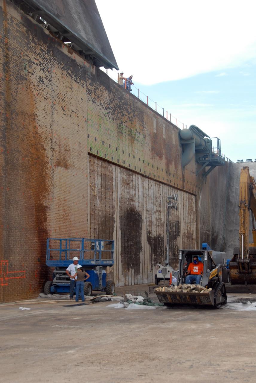
In the Vehicle Assembly Building, markers show the hail damage being repaired on the external tank of Space Shuttle Atlantis. The white hole with a red circle around it is a hole prepared for molding and material application. The red material is sealant tape so the mold doesn't leak when the foam rises against the mold. The white/ translucent square mold is an area where the foam has been applied and the foam has risen and cured against the mold surface. The area will be de-molded and sanded flush with the adjacent area. In late February, Atlantis' external tank received hail damage during a severe thunderstorm that passed through the Kennedy Space Center Launch Complex 39 area. The hail caused visible divots in the giant tank's foam insulation as well as minor surface damage to about 26 heat shield tiles on the shuttle's left wing. The launch now is targeted for June 8.
The roof of the Operations Support Building I is seen during an aerial survey of NASA's Kennedy Space Center in Florida on Saturday. The survey was performed to identify structures and facilities that may have sustained damage from Hurricane Matthew as the storm passed to the east of Kennedy on Oct. 6 and 7, 2016. Officials determined that the center received some isolated roof damage, damaged support buildings, a few downed power lines, and limited water intrusion. Beach erosion also occurred, although the storm surge was less than expected. NASA closed the center ahead of the storm’s onset and only a small team of specialists known as the Rideout Team was on the center as the storm approached and passed.
Launch Complex 39B is seen during an aerial survey of NASA's Kennedy Space Center in Florida on Saturday. The survey was performed to identify structures and facilities that may have sustained damage from Hurricane Matthew as the storm passed to the east of Kennedy on Oct. 6 and 7, 2016. Officials determined that the center received some isolated roof damage, damaged support buildings, a few downed power lines, and limited water intrusion. Beach erosion also occurred, although the storm surge was less than expected. NASA closed the center ahead of the storm’s onset and only a small team of specialists known as the Rideout Team was on the center as the storm approached and passed
The Launch Complex 39 area is seen during an aerial survey of NASA's Kennedy Space Center in Florida on Saturday. The survey was performed to identify structures and facilities that may have sustained damage from Hurricane Matthew as the storm passed to the east of Kennedy on Oct. 6 and 7, 2016. Officials determined that the center received some isolated roof damage, damaged support buildings, a few downed power lines, and limited water intrusion. Beach erosion also occurred, although the storm surge was less than expected. NASA closed the center ahead of the storm’s onset and only a small team of specialists known as the Rideout Team was on the center as the storm approached and passed.
A support building is seen during an aerial survey of NASA's Kennedy Space Center in Florida on Saturday. The survey was performed to identify structures and facilities that may have sustained damage from Hurricane Matthew as the storm passed to the east of Kennedy on Oct. 6 and 7, 2016. Officials determined that the center received some isolated roof damage, damaged support buildings, a few downed power lines, and limited water intrusion. Beach erosion also occurred, although the storm surge was less than expected. NASA closed the center ahead of the storm’s onset and only a small team of specialists known as the Rideout Team was on the center as the storm approached and passed.
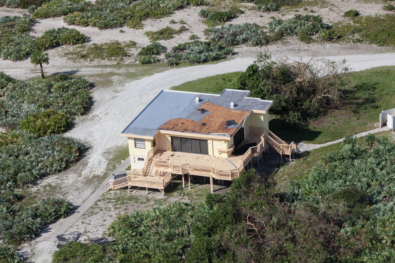
The Beach House is seen during an aerial survey of NASA's Kennedy Space Center in Florida on Saturday. The survey was performed to identify structures and facilities that may have sustained damage from Hurricane Matthew as the storm passed to the east of Kennedy on Oct. 6 and 7, 2016. Officials determined that the center received some isolated roof damage, damaged support buildings, a few downed power lines, and limited water intrusion. Beach erosion also occurred, although the storm surge was less than expected. NASA closed the center ahead of the storm’s onset and only a small team of specialists known as the Rideout Team was on the center as the storm approached and passed
The roof of the Operations Support Building II is seen during an aerial survey of NASA's Kennedy Space Center in Florida on Saturday. The survey was performed to identify structures and facilities that may have sustained damage from Hurricane Matthew as the storm passed to the east of Kennedy on Oct. 6 and 7, 2016. Officials determined that the center received some isolated roof damage, damaged support buildings, a few downed power lines, and limited water intrusion. Beach erosion also occurred, although the storm surge was less than expected. NASA closed the center ahead of the storm’s onset and only a small team of specialists known as the Rideout Team was on the center as the storm approached and passed.
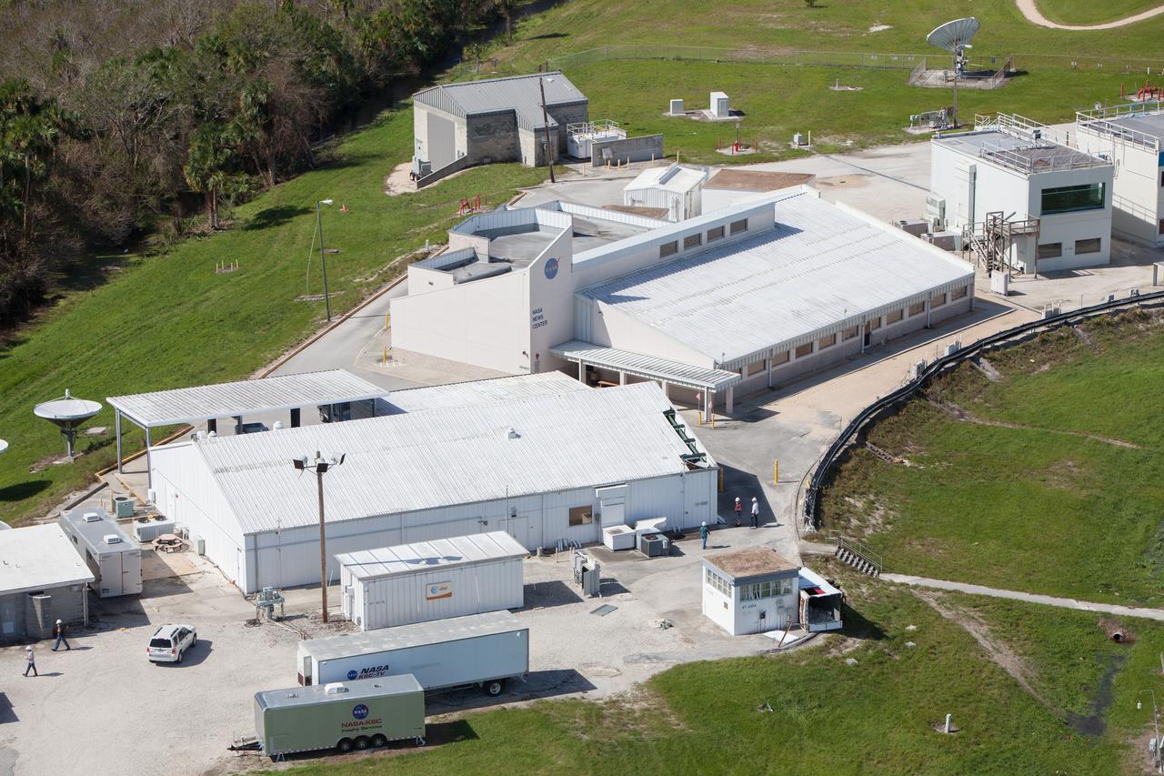
The NASA News Center is seen during an aerial survey of NASA's Kennedy Space Center in Florida on Saturday. The survey was performed to identify structures and facilities that may have sustained damage from Hurricane Matthew as the storm passed to the east of Kennedy on Oct. 6 and 7, 2016. Officials determined that the center received some isolated roof damage, damaged support buildings, a few downed power lines, and limited water intrusion. Beach erosion also occurred, although the storm surge was less than expected. NASA closed the center ahead of the storm’s onset and only a small team of specialists known as the Rideout Team was on the center as the storm approached and passed
The roof of the Operations Support Building II is seen during an aerial survey of NASA's Kennedy Space Center in Florida on Saturday. The survey was performed to identify structures and facilities that may have sustained damage from Hurricane Matthew as the storm passed to the east of Kennedy on Oct. 6 and 7, 2016. Officials determined that the center received some isolated roof damage, damaged support buildings, a few downed power lines, and limited water intrusion. Beach erosion also occurred, although the storm surge was less than expected. NASA closed the center ahead of the storm’s onset and only a small team of specialists known as the Rideout Team was on the center as the storm approached and passed.
The Central Campus construction site is seen during an aerial survey of NASA's Kennedy Space Center in Florida on Saturday. The survey was performed to identify structures and facilities that may have sustained damage from Hurricane Matthew as the storm passed to the east of Kennedy on Oct. 6 and 7, 2016. Officials determined that the center received some isolated roof damage, damaged support buildings, a few downed power lines, and limited water intrusion. Beach erosion also occurred, although the storm surge was less than expected. NASA closed the center ahead of the storm’s onset and only a small team of specialists known as the Rideout Team was on the center as the storm approached and passed
Launch Complex 39B is seen during an aerial survey of NASA's Kennedy Space Center in Florida on Saturday. The survey was performed to identify structures and facilities that may have sustained damage from Hurricane Matthew as the storm passed to the east of Kennedy on Oct. 6 and 7, 2016. Officials determined that the center received some isolated roof damage, damaged support buildings, a few downed power lines, and limited water intrusion. Beach erosion also occurred, although the storm surge was less than expected. NASA closed the center ahead of the storm’s onset and only a small team of specialists known as the Rideout Team was on the center as the storm approached and passed.
The NASA TV Support Building at the NASA News Center is seen during an aerial survey of NASA's Kennedy Space Center in Florida on Saturday. The survey was performed to identify structures and facilities that may have sustained damage from Hurricane Matthew as the storm passed to the east of Kennedy on Oct. 6 and 7, 2016. Officials determined that the center received some isolated roof damage, damaged support buildings, a few downed power lines, and limited water intrusion. Beach erosion also occurred, although the storm surge was less than expected. NASA closed the center ahead of the storm’s onset and only a small team of specialists known as the Rideout Team was on the center as the storm approached and passed.
A support building is seen during an aerial survey of NASA's Kennedy Space Center in Florida on Saturday. The survey was performed to identify structures and facilities that may have sustained damage from Hurricane Matthew as the storm passed to the east of Kennedy on Oct. 6 and 7, 2016. Officials determined that the center received some isolated roof damage, damaged support buildings, a few downed power lines, and limited water intrusion. Beach erosion also occurred, although the storm surge was less than expected. NASA closed the center ahead of the storm’s onset and only a small team of specialists known as the Rideout Team was on the center as the storm approached and passed.
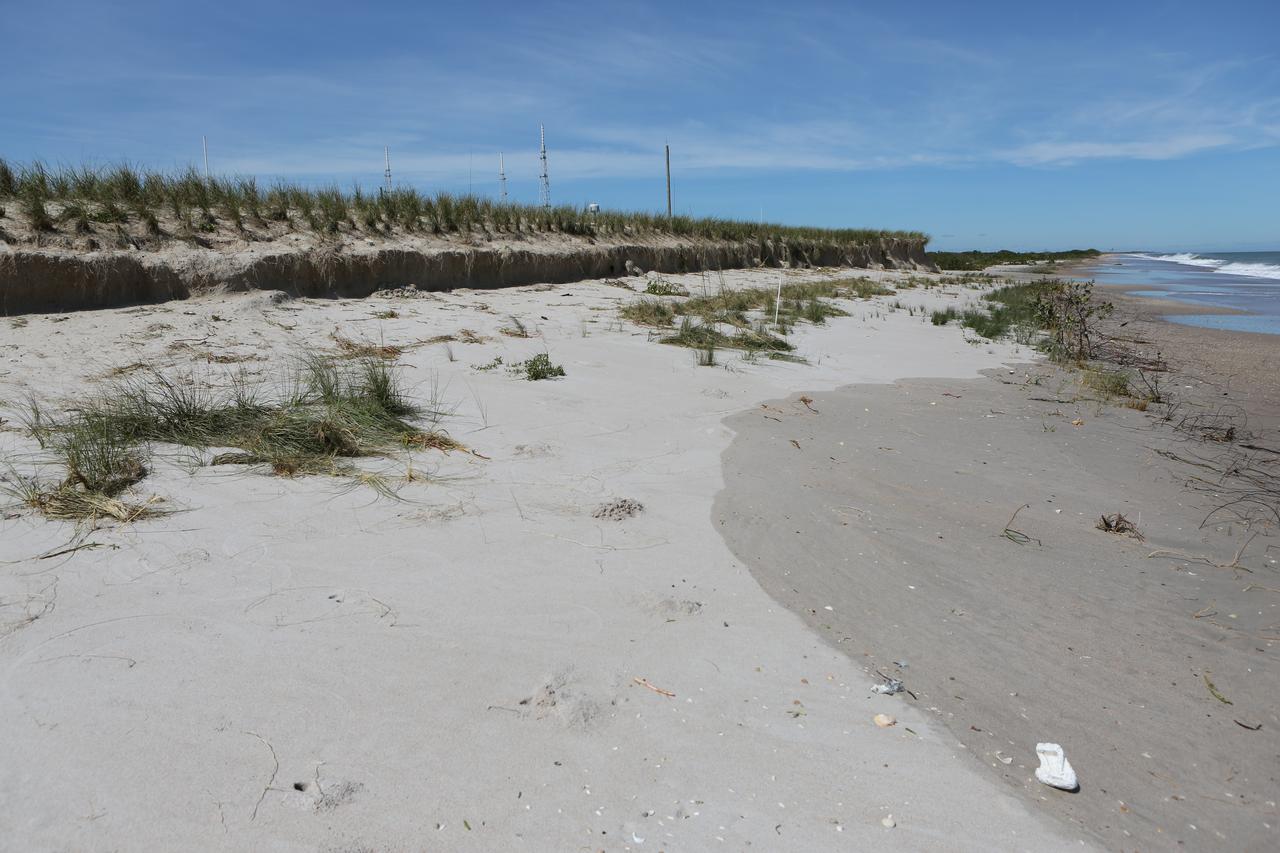
A beach area is seen during a survey of NASA's Kennedy Space Center in Florida on Saturday. The survey was performed to identify structures and facilities that may have sustained damage from Hurricane Matthew as the storm passed to the east of Kennedy on Oct. 6 and 7, 2016. Officials determined that the center received some isolated roof damage, damaged support buildings, a few downed power lines, and limited water intrusion. Beach erosion also occurred, although the storm surge was less than expected. NASA closed the center ahead of the storm’s onset and only a small team of specialists known as the Rideout Team was on the center as the storm approached and passed.
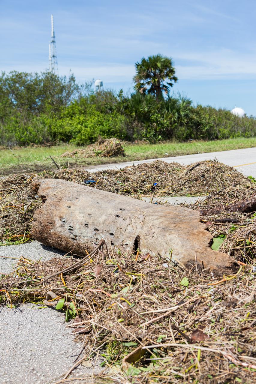
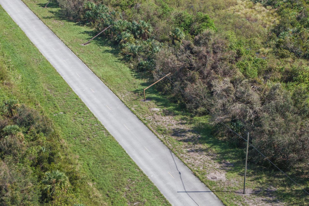
A tree is seen across a road during a survey of NASA's Kennedy Space Center in Florida on Saturday. The survey was performed to identify structures and facilities that may have sustained damage from Hurricane Matthew as the storm passed to the east of Kennedy on Oct. 6 and 7, 2016. Officials determined that the center received some isolated roof damage, damaged support buildings, a few downed power lines, and limited water intrusion. Beach erosion also occurred, although the storm surge was less than expected. NASA closed the center ahead of the storm’s onset and only a small team of specialists known as the Rideout Team was on the center as the storm approached and passed.
The Beach House is seen during an aerial survey of NASA's Kennedy Space Center in Florida on Saturday. The survey was performed to identify structures and facilities that may have sustained damage from Hurricane Matthew as the storm passed to the east of Kennedy on Oct. 6 and 7, 2016. Officials determined that the center received some isolated roof damage, damaged support buildings, a few downed power lines, and limited water intrusion. Beach erosion also occurred, although the storm surge was less than expected. NASA closed the center ahead of the storm’s onset and only a small team of specialists known as the Rideout Team was on the center as the storm approached and passed.
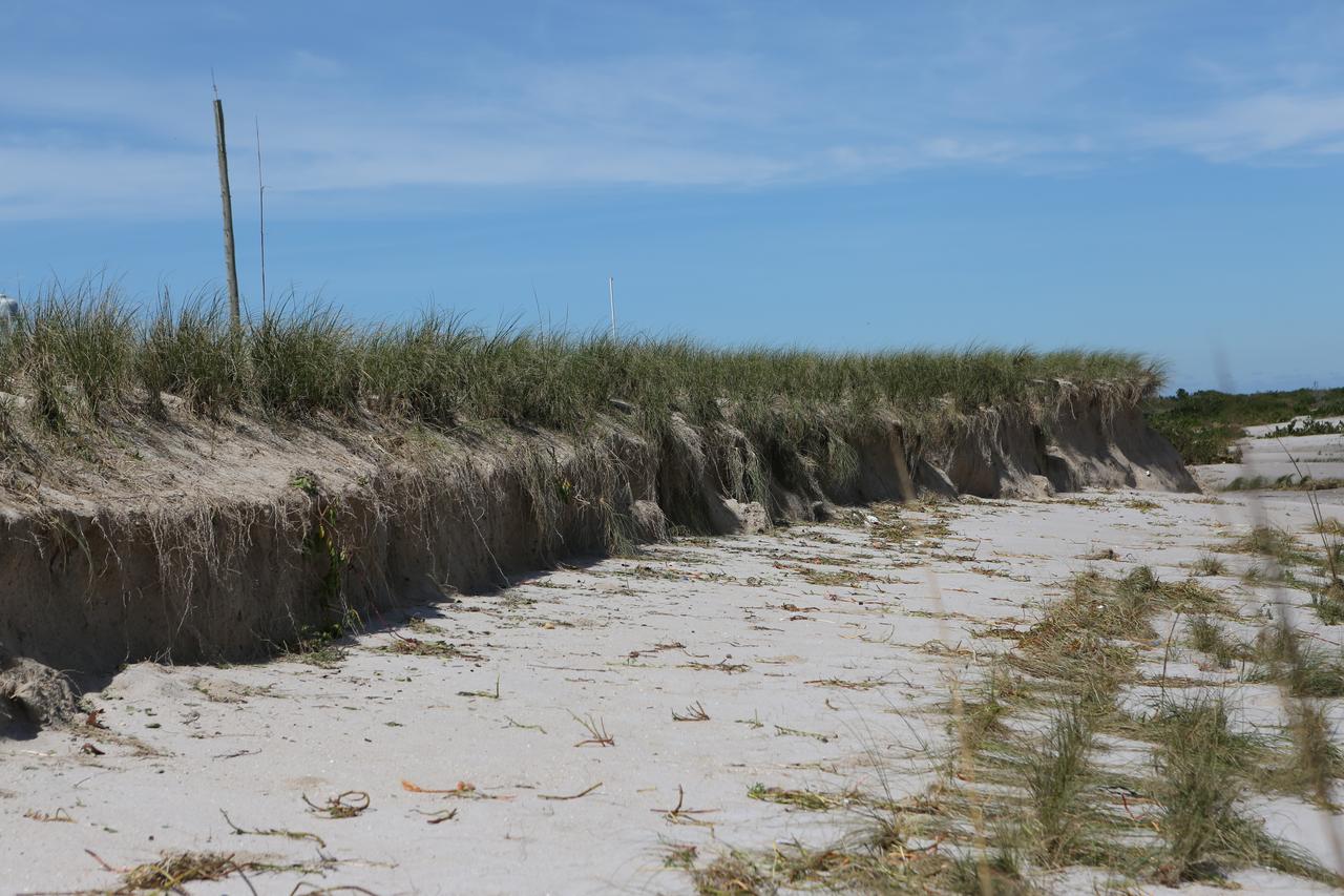
A beach area is seen during a survey of NASA's Kennedy Space Center in Florida on Saturday. The survey was performed to identify structures and facilities that may have sustained damage from Hurricane Matthew as the storm passed to the east of Kennedy on Oct. 6 and 7, 2016. Officials determined that the center received some isolated roof damage, damaged support buildings, a few downed power lines, and limited water intrusion. Beach erosion also occurred, although the storm surge was less than expected. NASA closed the center ahead of the storm’s onset and only a small team of specialists known as the Rideout Team was on the center as the storm approached and passed.
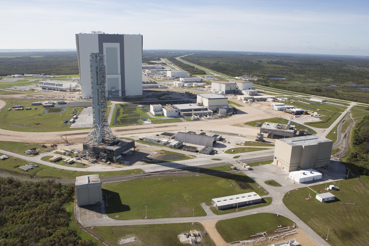
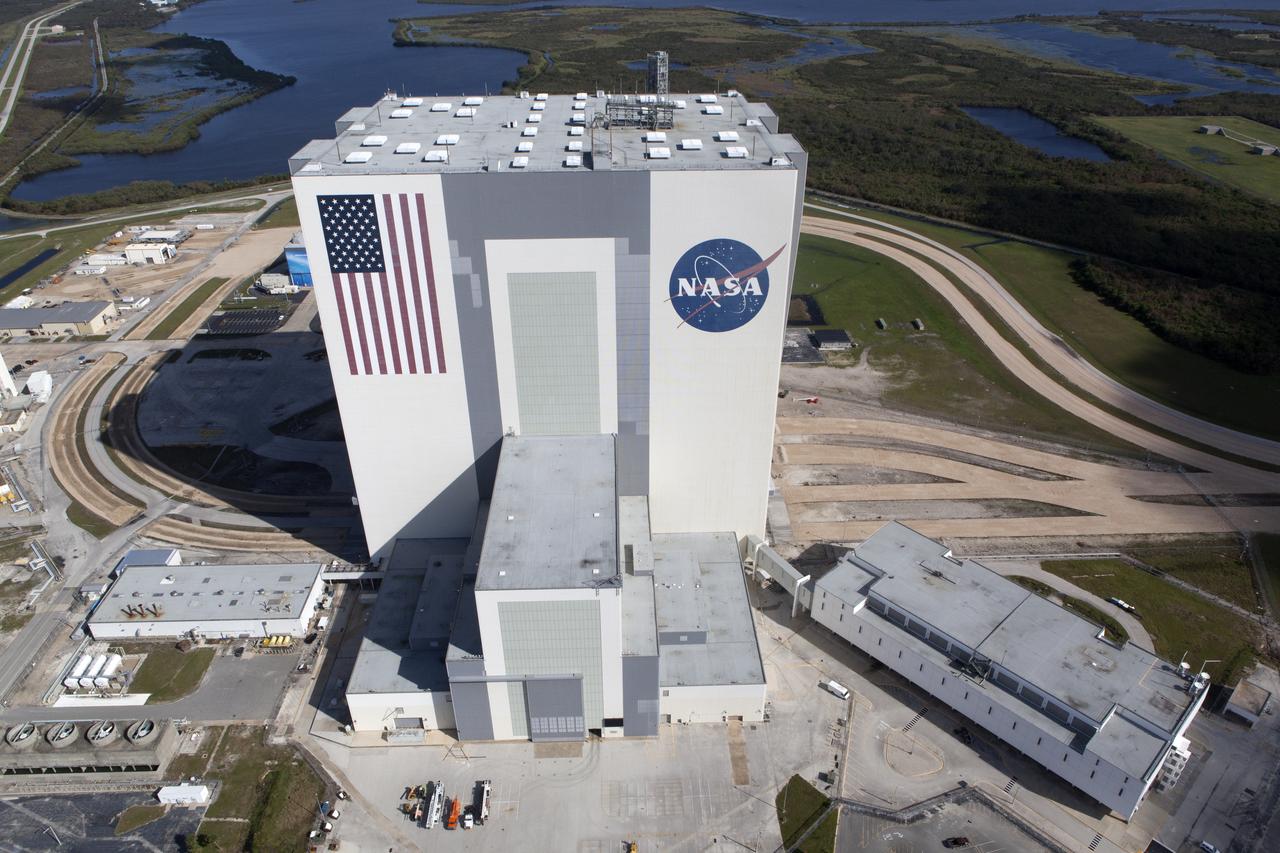
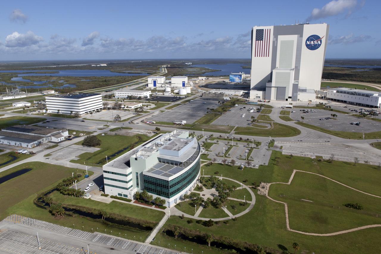
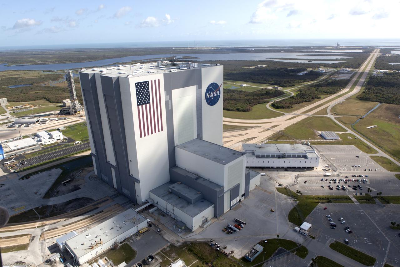
The Vehicle Assembly Building is seen during an aerial survey of NASA's Kennedy Space Center in Florida on Saturday. The survey was performed to identify structures and facilities that may have sustained damage from Hurricane Matthew as the storm passed to the east of Kennedy on Oct. 6 and 7, 2016. Officials determined that the center received some isolated roof damage, damaged support buildings, a few downed power lines, and limited water intrusion. Beach erosion also occurred, although the storm surge was less than expected. NASA closed the center ahead of the storm’s onset and only a small team of specialists known as the Rideout Team was on the center as the storm approached and passed.
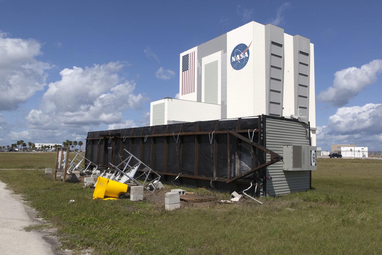
A display area in front of the Vehicle Assembly Building is seen during an aerial survey of NASA's Kennedy Space Center in Florida on Saturday. The survey was performed to identify structures and facilities that may have sustained damage from Hurricane Matthew as the storm passed to the east of Kennedy on Oct. 6 and 7, 2016. Officials determined that the center received some isolated roof damage, damaged support buildings, a few downed power lines, and limited water intrusion. Beach erosion also occurred, although the storm surge was less than expected. NASA closed the center ahead of the storm’s onset and only a small team of specialists known as the Rideout Team was on the center as the storm approached and passed.
The NASA TV Support Building at the NASA News Center is seen during an aerial survey of NASA's Kennedy Space Center in Florida on Saturday. The survey was performed to identify structures and facilities that may have sustained damage from Hurricane Matthew as the storm passed to the east of Kennedy on Oct. 6 and 7, 2016. Officials determined that the center received some isolated roof damage, damaged support buildings, a few downed power lines, and limited water intrusion. Beach erosion also occurred, although the storm surge was less than expected. NASA closed the center ahead of the storm’s onset and only a small team of specialists known as the Rideout Team was on the center as the storm approached and passed.
A support building is seen during an aerial survey of NASA's Kennedy Space Center in Florida on Saturday. The survey was performed to identify structures and facilities that may have sustained damage from Hurricane Matthew as the storm passed to the east of Kennedy on Oct. 6 and 7, 2016. Officials determined that the center received some isolated roof damage, damaged support buildings, a few downed power lines, and limited water intrusion. Beach erosion also occurred, although the storm surge was less than expected. NASA closed the center ahead of the storm’s onset and only a small team of specialists known as the Rideout Team was on the center as the storm approached and passed.
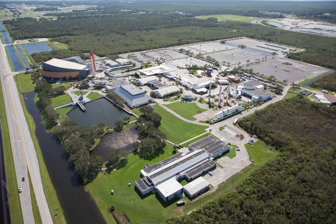
The Kennedy Space Center Visitor Complex is seen during an aerial survey of NASA's Kennedy Space Center in Florida on Saturday. The survey was performed to identify structures and facilities that may have sustained damage from Hurricane Matthew as the storm passed to the east of Kennedy on Oct. 6 and 7, 2016. Officials determined that the center received some isolated roof damage, damaged support buildings, a few downed power lines, and limited water intrusion. Beach erosion also occurred, although the storm surge was less than expected. NASA closed the center ahead of the storm’s onset and only a small team of specialists known as the Rideout Team was on the center as the storm approached and passed.
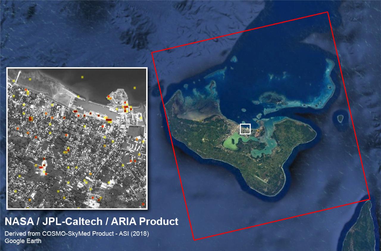
The Advanced Rapid Imaging and Analysis (ARIA) team at NASA's Jet Propulsion Laboratory created this Damage Proxy Map (DPM) of Tongatapu, the main island of Tonga, following the landfall of Cyclone Gita, a Category 4 storm that hit Tonga on Feb. 12-13, 2018. The map depicts areas that are likely damaged from the storm, shown by red and yellow pixels. The map was produced by comparing two pairs of interferometric synthetic aperture radar (InSAR) images from the COSMO-SkyMed satellites, operated by the Italian Space Agency (ASI). The pre- and post-cyclone images were acquired on Jan. 19 and Feb. 13, 2018, respectively. The later image was acquired just 4-1/2 hours after the peak damage by the cyclone. The map covers the entire island of Tongatapu (the 25-by-25-mile, or 40-by-40 kilometer SAR image footprint indicated with the large red polygon). Each pixel measures about 98 feet (30 meters) across. The color variation from yellow to red indicates increasingly more significant ground surface change. Preliminary validation of the SAR data was done by comparing them with high-resolution optical imagery acquired by DigitalGlobe. This Damage Proxy Map should be used as guidance to identify damaged areas and may be less reliable over vegetated and flooded areas. https://photojournal.jpl.nasa.gov/catalog/PIA22257
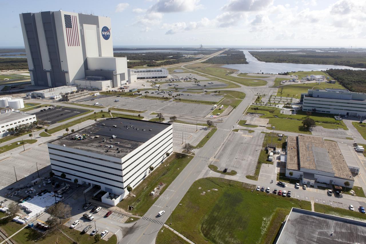
The Vehicle Assembly Building (VAB), Launch Control Center (LCC), and Launch Complex 39 surrounding areas are seen during an aerial survey of NASA's Kennedy Space Center in Florida on September 12, 2017. The survey was performed to identify structures and facilities that may have sustained damage from Hurricane Irma as the storm passed Kennedy on September 10, 2017. NASA closed the center ahead of the storm's onset and only a small team of specialists known as the Rideout Team was on the center as the storm approached and passed.
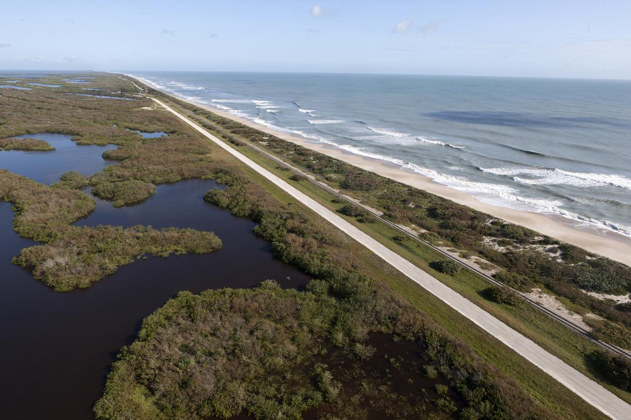
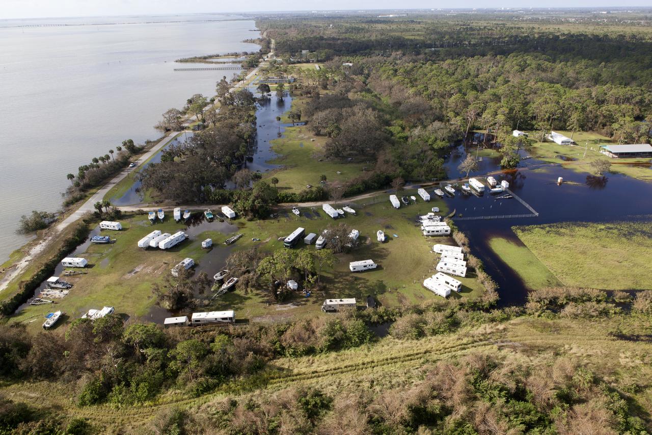
The shoreline is seen during an aerial survey of NASA's Kennedy Space Center in Florida on September 12, 2017. The survey was performed to identify structures and facilities that may have sustained damage from Hurricane Irma as the storm passed Kennedy on September 10, 2017. NASA closed the center ahead of the storm's onset and only a small team of specialists known as the Rideout Team was on the center as the storm approached and passed.
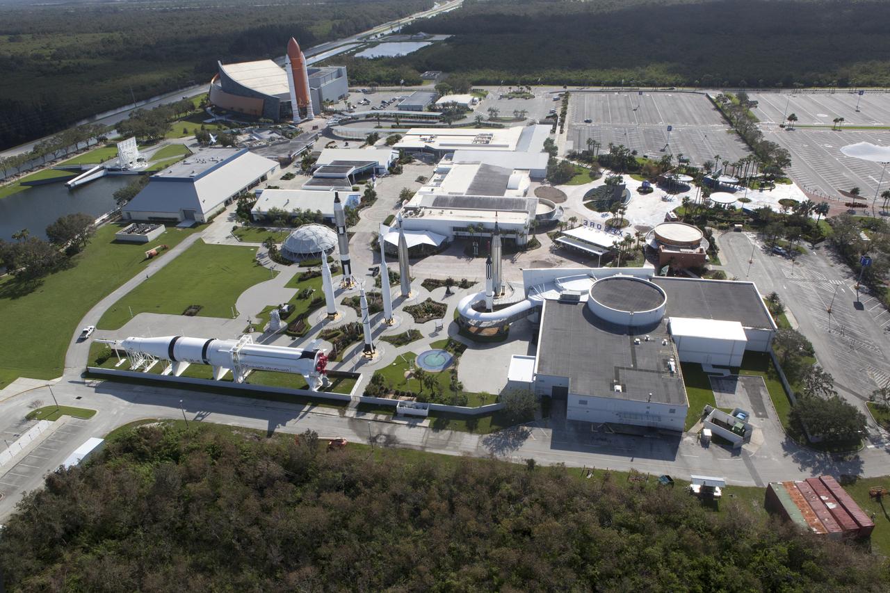
The Kennedy Space Center Visitor Complex is seen during an aerial survey of NASA's Kennedy Space Center in Florida on September 12, 2017. The survey was performed to identify structures and facilities that may have sustained damage from Hurricane Irma as the storm passed Kennedy on September 10, 2017. NASA closed the center ahead of the storm's onset and only a small team of specialists known as the Rideout Team was on the center as the storm approached and passed.
The Launch Complex 39 Press Site is seen during an aerial survey of NASA's Kennedy Space Center in Florida on September 12, 2017. The survey was performed to identify structures and facilities that may have sustained damage from Hurricane Irma as the storm passed Kennedy on September 10, 2017. NASA closed the center ahead of the storm's onset and only a small team of specialists known as the Rideout Team was on the center as the storm approached and passed.
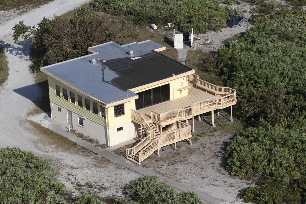
The Beach House is seen during an aerial survey of NASA's Kennedy Space Center in Florida on September 12, 2017. The survey was performed to identify structures and facilities that may have sustained damage from Hurricane Irma as the storm passed Kennedy on September 10, 2017. NASA closed the center ahead of the storm's onset and only a small team of specialists known as the Rideout Team was on the center as the storm approached and passed.
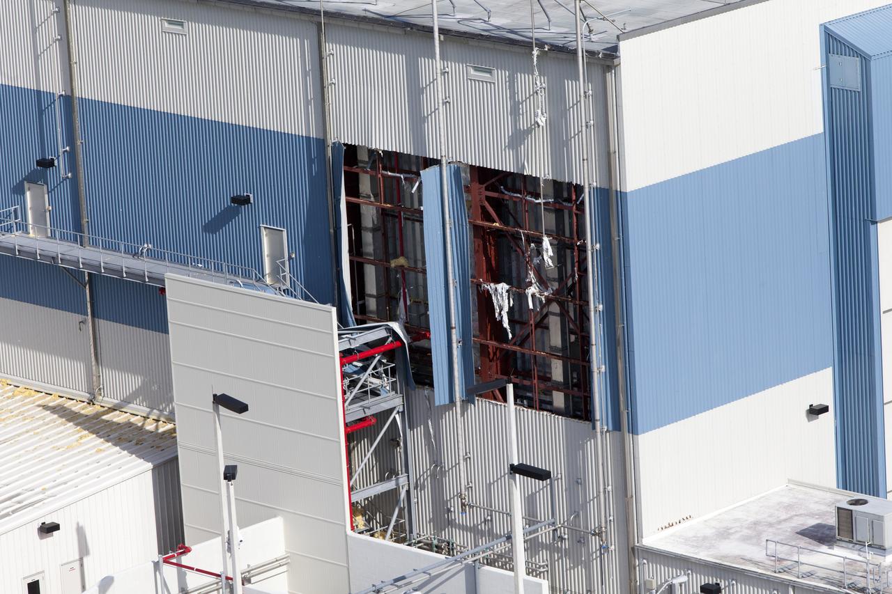
An industrial building behind the Space Station Processing Facility (SSPF) is seen during an aerial survey of NASA's Kennedy Space Center in Florida on September 12, 2017. The survey was performed to identify structures and facilities that may have sustained damage from Hurricane Irma as the storm passed Kennedy on September 10, 2017. NASA closed the center ahead of the storm's onset and only a small team of specialists known as the Rideout Team was on the center as the storm approached and passed.
The Mobile Launcher (ML), Vehicle Assembly Building (VAB), Launch Control Center (LCC), and Launch Complex 39 surrounding areas are seen during an aerial survey of NASA's Kennedy Space Center in Florida on September 12, 2017. The survey was performed to identify structures and facilities that may have sustained damage from Hurricane Irma as the storm passed Kennedy on September 10, 2017. NASA closed the center ahead of the storm's onset and only a small team of specialists known as the Rideout Team was on the center as the storm approached and passed.
The Blue Origin construction site at Exploration Park is seen during an aerial survey of NASA's Kennedy Space Center in Florida on September 12, 2017. The survey was performed to identify structures and facilities that may have sustained damage from Hurricane Irma as the storm passed Kennedy on September 10, 2017. NASA closed the center ahead of the storm's onset and only a small team of specialists known as the Rideout Team was on the center as the storm approached and passed.
Launch Complex 39 surrounding areas are seen during an aerial survey of NASA's Kennedy Space Center in Florida on September 12, 2017. The survey was performed to identify structures and facilities that may have sustained damage from Hurricane Irma as the storm passed Kennedy on September 10, 2017. NASA closed the center ahead of the storm's onset and only a small team of specialists known as the Rideout Team was on the center as the storm approached and passed.
Kars Park I is seen during an aerial survey of NASA's Kennedy Space Center in Florida on September 12, 2017. The survey was performed to identify structures and facilities that may have sustained damage from Hurricane Irma as the storm passed Kennedy on September 10, 2017. NASA closed the center ahead of the storm's onset and only a small team of specialists known as the Rideout Team was on the center as the storm approached and passed.
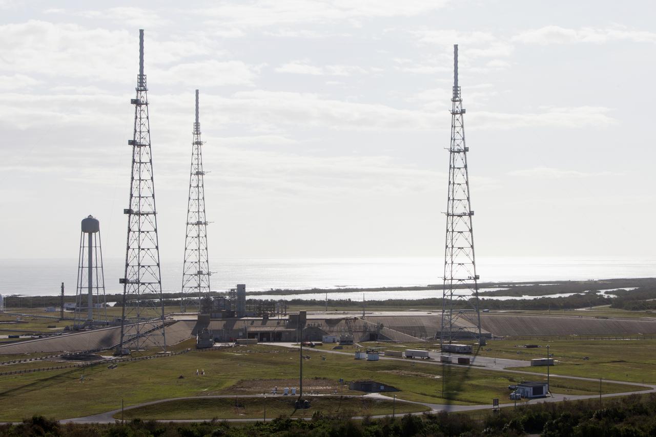
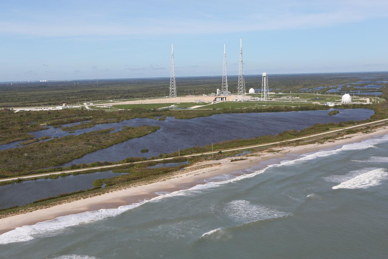
Launch Complex 39B is seen during an aerial survey of NASA's Kennedy Space Center in Florida on September 12, 2017. The survey was performed to identify structures and facilities that may have sustained damage from Hurricane Irma as the storm passed Kennedy on September 10, 2017. NASA closed the center ahead of the storm's onset and only a small team of specialists known as the Rideout Team was on the center as the storm approached and passed.
Kars Park I is seen during an aerial survey of NASA's Kennedy Space Center in Florida on September 12, 2017. The survey was performed to identify structures and facilities that may have sustained damage from Hurricane Irma as the storm passed Kennedy on September 10, 2017. NASA closed the center ahead of the storm's onset and only a small team of specialists known as the Rideout Team was on the center as the storm approached and passed.
A tank stroage unit near Launch Complex 39 is seen during an aerial survey of NASA's Kennedy Space Center in Florida on September 12, 2017. The survey was performed to identify structures and facilities that may have sustained damage from Hurricane Irma as the storm passed Kennedy on September 10, 2017. NASA closed the center ahead of the storm's onset and only a small team of specialists known as the Rideout Team was on the center as the storm approached and passed.
Launch Complex 39B is seen during an aerial survey of NASA's Kennedy Space Center in Florida on September 12, 2017. The survey was performed to identify structures and facilities that may have sustained damage from Hurricane Irma as the storm passed Kennedy on September 10, 2017. NASA closed the center ahead of the storm's onset and only a small team of specialists known as the Rideout Team was on the center as the storm approached and passed.
The Mobile Launcher (ML), Launch Control Center (LCC), Vehicle Assembly Building (VAB), and Launch Complex 39 surrounding areas are seen during an aerial survey of NASA's Kennedy Space Center in Florida on September 12, 2017. The survey was performed to identify structures and facilities that may have sustained damage from Hurricane Irma as the storm passed Kennedy on September 10, 2017. NASA closed the center ahead of the storm's onset and only a small team of specialists known as the Rideout Team was on the center as the storm approached and passed.
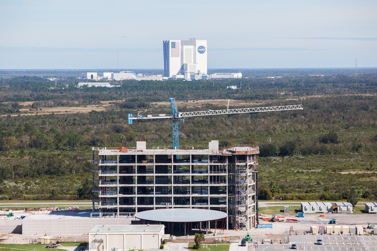
The Central Campus construction site and Headquarters building are seen during an aerial survey of NASA's Kennedy Space Center in Florida on September 12, 2017. The survey was performed to identify structures and facilities that may have sustained damage from Hurricane Irma as the storm passed Kennedy on September 10, 2017. NASA closed the center ahead of the storm's onset and only a small team of specialists known as the Rideout Team was on the center as the storm approached and passed.
Launch Complex 39 surrounding areas are seen during an aerial survey of NASA's Kennedy Space Center in Florida on September 12, 2017. The survey was performed to identify structures and facilities that may have sustained damage from Hurricane Irma as the storm passed Kennedy on September 10, 2017. NASA closed the center ahead of the storm's onset and only a small team of specialists known as the Rideout Team was on the center as the storm approached and passed.
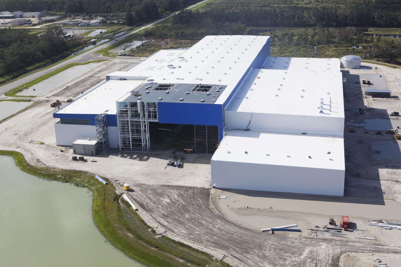
The Blue Origin construction site at Exploration Park is seen during an aerial survey of NASA's Kennedy Space Center in Florida on September 12, 2017. The survey was performed to identify structures and facilities that may have sustained damage from Hurricane Irma as the storm passed Kennedy on September 10, 2017. NASA closed the center ahead of the storm's onset and only a small team of specialists known as the Rideout Team was on the center as the storm approached and passed.
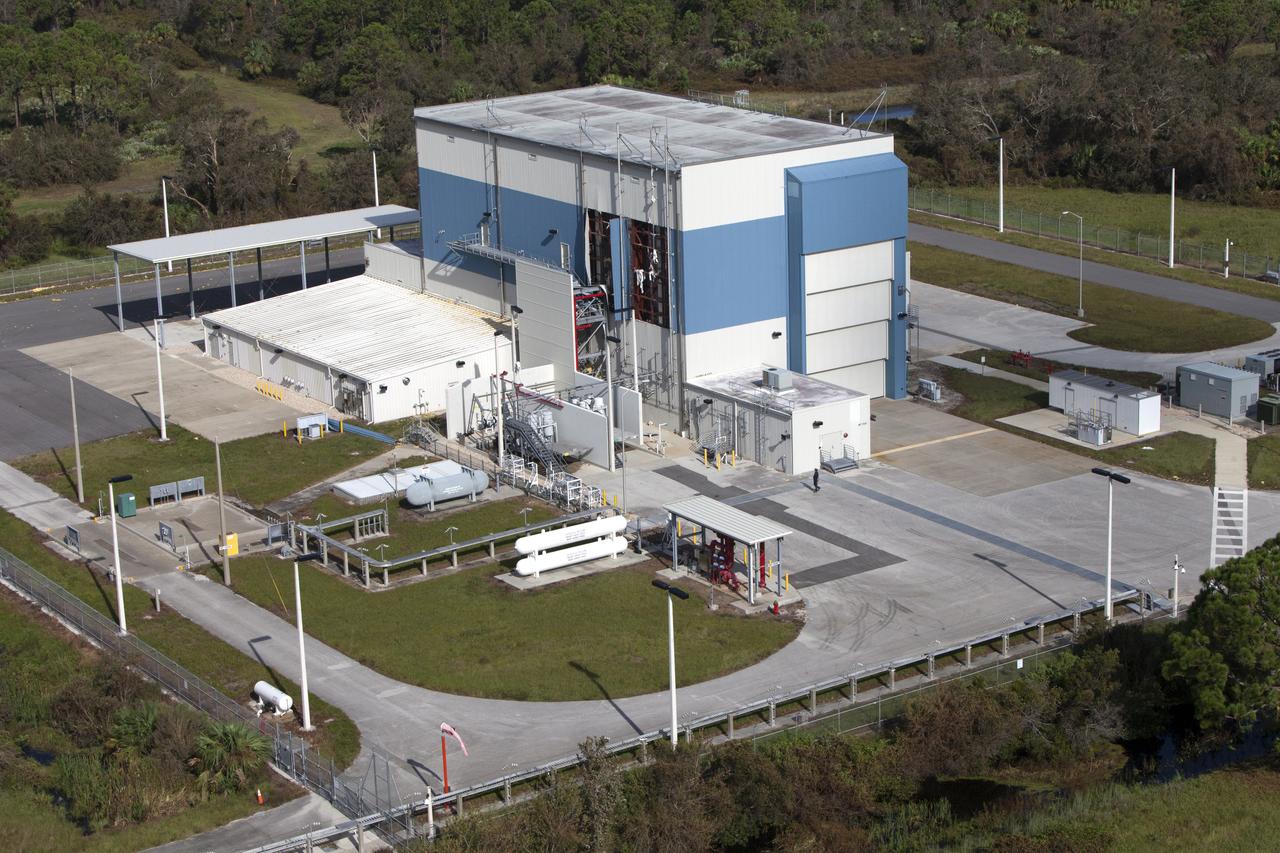
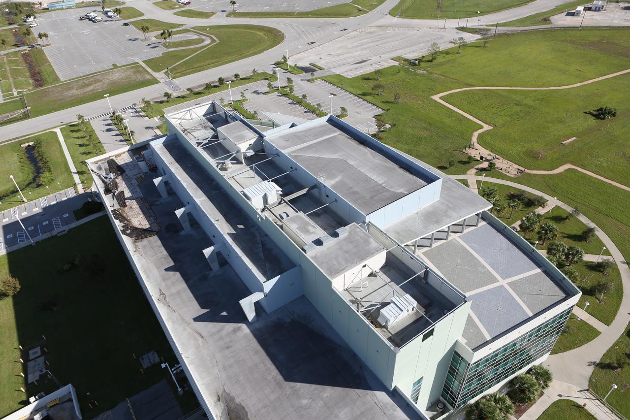
The Multi-Payload Processing Facility (MPPF) is seen during an aerial survey of NASA's Kennedy Space Center in Florida on September 12, 2017. The survey was performed to identify structures and facilities that may have sustained damage from Hurricane Irma as the storm passed Kennedy on September 10, 2017. NASA closed the center ahead of the storm's onset and only a small team of specialists known as the Rideout Team was on the center as the storm approached and passed.
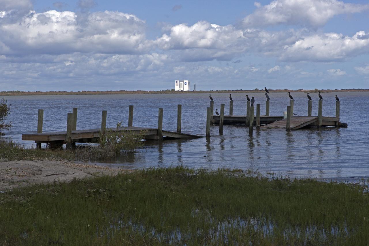
A boat dock torn apart is seen during a survey of NASA's Kennedy Space Center in Florida on September 12, 2017. The survey was performed to identify structures and facilities that may have sustained damage from Hurricane Irma as the storm passed Kennedy on September 10, 2017. NASA closed the center ahead of the storm's onset and only a small team of specialists known as the Rideout Team was on the center as the storm approached and passed.
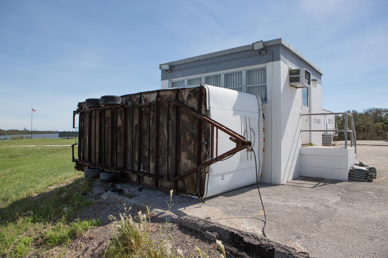
A trailer flipped on it's side at the Turn Basin is seen during a survey of NASA's Kennedy Space Center in Florida on September 12, 2017. The survey was performed to identify structures and facilities that may have sustained damage from Hurricane Irma as the storm passed Kennedy on September 10, 2017. NASA closed the center ahead of the storm's onset and only a small team of specialists known as the Rideout Team was on the center as the storm approached and passed.
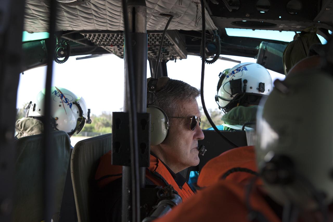
Center Director, Robert Cabana, conducts an aerial survey of NASA's Kennedy Space Center in Florida on September 12, 2017. The survey was performed to identify structures and facilities that may have sustained damage from Hurricane Irma as the storm passed Kennedy on September 10, 2017. NASA closed the center ahead of the storm's onset and only a small team of specialists known as the Rideout Team was on the center as the storm approached and passed.
The Mobile Launcher (ML), Vehicle Assembly Building (VAB), Launch Control Center (LCC), and Launch Complex 39 surrounding areas are seen during an aerial survey of NASA's Kennedy Space Center in Florida on September 12, 2017. The survey was performed to identify structures and facilities that may have sustained damage from Hurricane Irma as the storm passed Kennedy on September 10, 2017. NASA closed the center ahead of the storm's onset and only a small team of specialists known as the Rideout Team was on the center as the storm approached and passed.
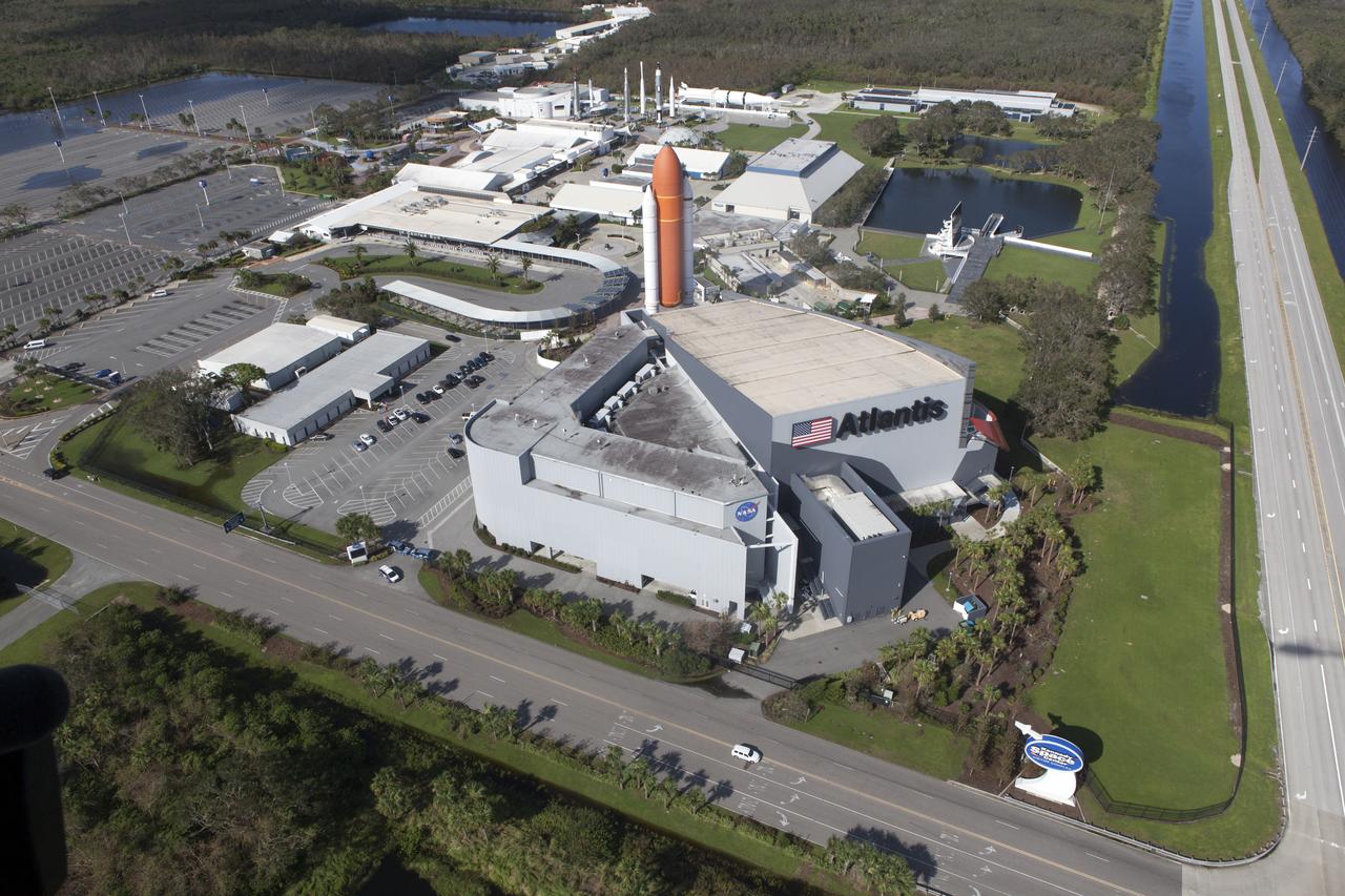
The Kennedy Space Center Visitor Complex is seen during an aerial survey of NASA's Kennedy Space Center in Florida on September 12, 2017. The survey was performed to identify structures and facilities that may have sustained damage from Hurricane Irma as the storm passed Kennedy on September 10, 2017. NASA closed the center ahead of the storm's onset and only a small team of specialists known as the Rideout Team was on the center as the storm approached and passed.
The Launch Control Center (LCC) is seen during an aerial survey of NASA's Kennedy Space Center in Florida on September 12, 2017. The survey was performed to identify structures and facilities that may have sustained damage from Hurricane Irma as the storm passed Kennedy on September 10, 2017. NASA closed the center ahead of the storm's onset and only a small team of specialists known as the Rideout Team was on the center as the storm approached and passed.
Kars Park I is seen during an aerial survey of NASA's Kennedy Space Center in Florida on September 12, 2017. The survey was performed to identify structures and facilities that may have sustained damage from Hurricane Irma as the storm passed Kennedy on September 10, 2017. NASA closed the center ahead of the storm's onset and only a small team of specialists known as the Rideout Team was on the center as the storm approached and passed.
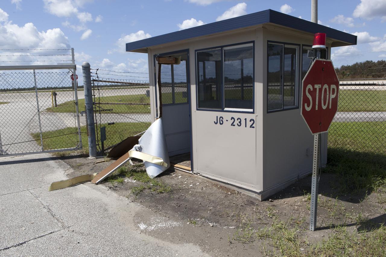
A guard shack at the Shuttle Landing Facility, operated by Space Florida, is seen during a survey of NASA's Kennedy Space Center in Florida on September 12, 2017. The survey was performed to identify structures and facilities that may have sustained damage from Hurricane Irma as the storm passed Kennedy on September 10, 2017. NASA closed the center ahead of the storm's onset and only a small team of specialists known as the Rideout Team was on the center as the storm approached and passed.
The Multi-Payload Processing Facility (MPPF) is seen during an aerial survey of NASA's Kennedy Space Center in Florida on September 12, 2017. The survey was performed to identify structures and facilities that may have sustained damage from Hurricane Irma as the storm passed Kennedy on September 10, 2017. NASA closed the center ahead of the storm's onset and only a small team of specialists known as the Rideout Team was on the center as the storm approached and passed.
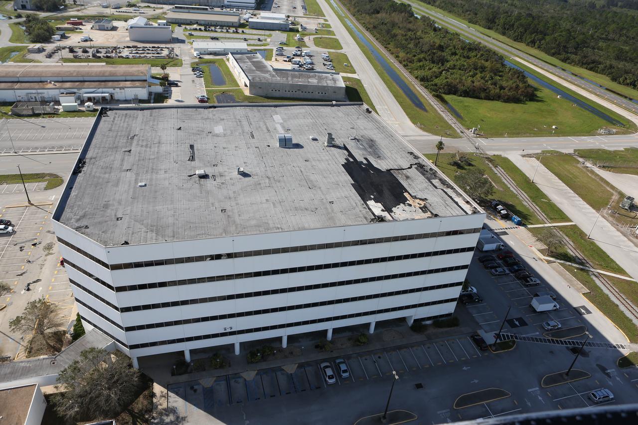
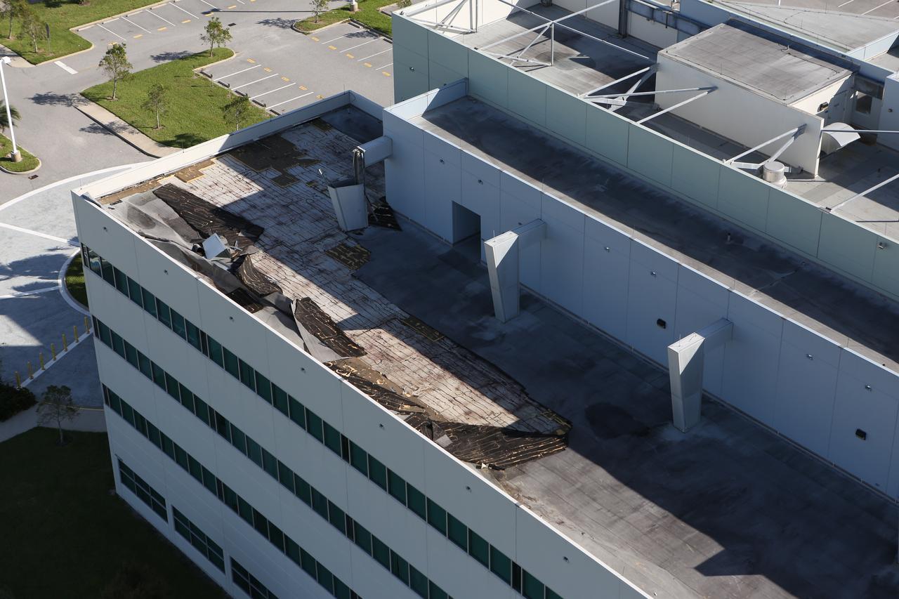
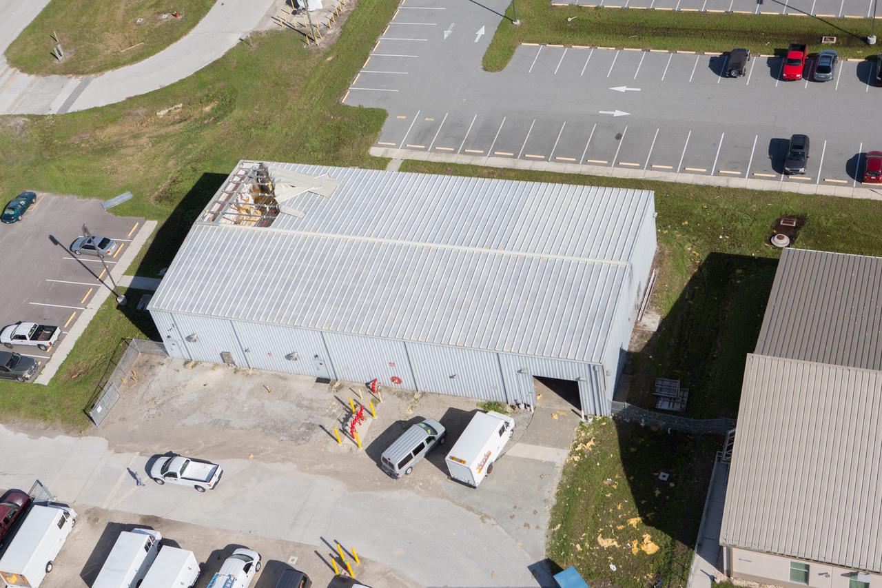
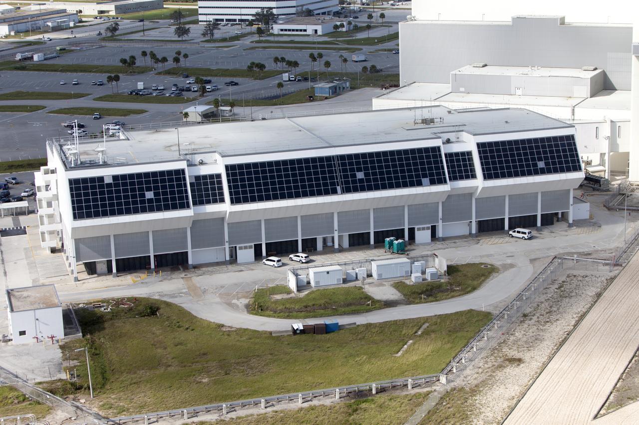
The Operations Support Building I (OSB I) is seen during an aerial survey of NASA's Kennedy Space Center in Florida on September 12, 2017. The roof of the building is currently undergoing repair from Hurricane Matthew. The survey was performed to identify structures and facilities that may have sustained damage from Hurricane Irma as the storm passed Kennedy on September 10, 2017. NASA closed the center ahead of the storm's onset and only a small team of specialists known as the Rideout Team was on the center as the storm approached and passed.

Bob Cabana, director of NASA's Kennedy Space Center in Florida, begins an aerial survey of the center on Saturday. The survey was performed to identify structures and facilities that may have sustained damage from Hurricane Matthew as the storm passed to the east of Kennedy on Oct. 6 and 7, 2016. Officials determined that the center received some isolated roof damage, damaged support buildings, a few downed power lines, and limited water intrusion. Beach erosion also occurred, although the storm surge was less than expected. NASA closed the center ahead of the storm’s onset and only a small team of specialists known as the Rideout Team was on the center as the storm approached and passed.
In the Vehicle Assembly Building, Mike Ravenscroft, with United Space Alliance, points to some of the foam repair done on the external tank of Space Shuttle Atlantis. Holes filled with foam are sanded flush with the adjacent area. In late February, Atlantis' external tank received hail damage during a severe thunderstorm that passed through the Kennedy Space Center Launch Complex 39 area. The hail caused visible divots in the giant tank's foam insulation as well as minor surface damage to about 26 heat shield tiles on the shuttle's left wing. The launch now is targeted for June 8.
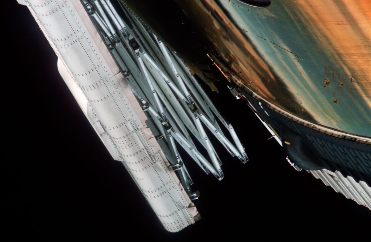
Close-up view of partially deployed, damaged solar array before astronauts performed extravehicular activity (EVA) to completey deploy it.
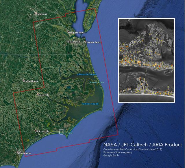
The Advanced Rapid Imaging and Analysis (ARIA) team at NASA's Jet Propulsion Laboratory in Pasadena, California, created this Damage Proxy Map (DPM) depicting areas of the Carolinas that are likely damaged (shown by red and yellow pixels) as a result of Hurricane Florence. The map is derived from synthetic aperture radar (SAR) images from the Copernicus Sentinel-1 satellites, operated by the European Space Agency (ESA). The images were taken before (September 02, 2016) and 12 hours after the hurricane's landfall (September 14, 2018 7:06 PM local time). The map covers an area of 155 miles x 210 miles (250 km x 340 km), indicated with the big red polygon. Each pixel measures about 33 yards x 33 yards (30 m x 30 m). The color variation from yellow to red indicates increasingly more significant ground surface change. Media reports provided anecdotal preliminary validation. This damage proxy map should be used as guidance to identify damaged areas, and may be less reliable over vegetated areas and flooded areas. For example, the scattered single colored pixels over vegetated areas may be false positives, and the lack of colored pixels over vegetated areas does not necessarily mean no damage. https://photojournal.jpl.nasa.gov/catalog/PIA22702
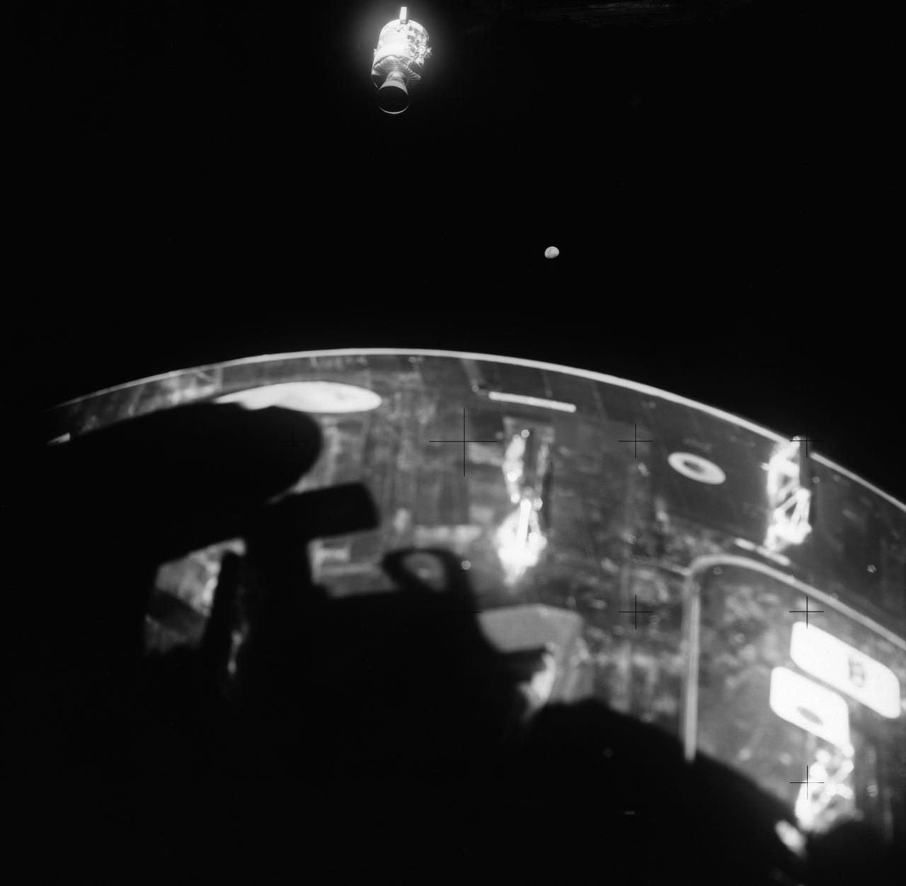
This view of the damaged Apollo 13 Service Module (SM) was photographed from the Lunar Module/Command Module following SM jettisoning. As seen here, an entire panel on the SM was blown away by the apparent explosion of oxygen tank number two located in Sector 4 of the SM. Two of the three fuel cells are visible just forward (above) the heavily damaged area. Three fuel cells, two oxygen tanks, and two hydrogen tanks are locate in Sector 4. The damaged area is located above the S-band high gain antenna. Nearest the camera is the Service Propulsion System (SPS) engine and nozzle. The damage to the SM caused the Apollo 13 crewmen to use the Lunar Module (LM) as a "lifeboat". The LM was jettisoned just prior to Earth reentry by the Command Module.
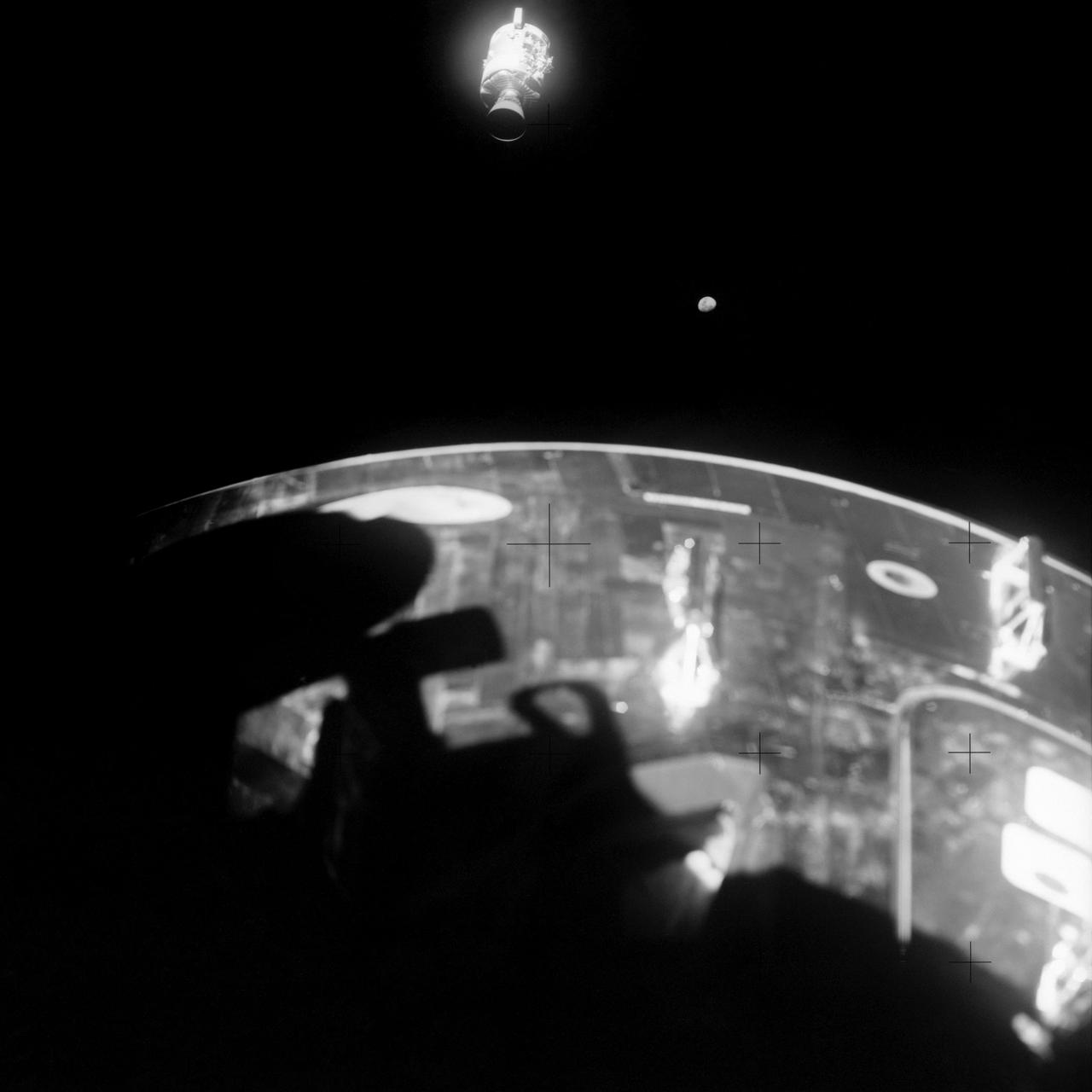
AS13-59-8501 (17 April 1970) --- This view of the severely damaged Apollo 13 Service Module (SM) was photographed from the Lunar Module/Command Module (LM/CM) following SM jettisoning. As seen here, an entire panel on the SM was blown away by the apparent explosion of oxygen tank number two located in Sector 4 of the SM. Two of the three fuel cells are visible just forward (above) the heavily damaged area. Three fuel cells, two oxygen tanks, and two hydrogen tanks are located in Sector 4. The damaged area is located above the S-Band high gain antenna. Nearest the camera is the Service Propulsion System (SPS) engine and nozzle. The damage to the SM caused the Apollo 13 crew men to use the LM as a "lifeboat." The LM was jettisoned just prior to Earth re-entry by the CM.
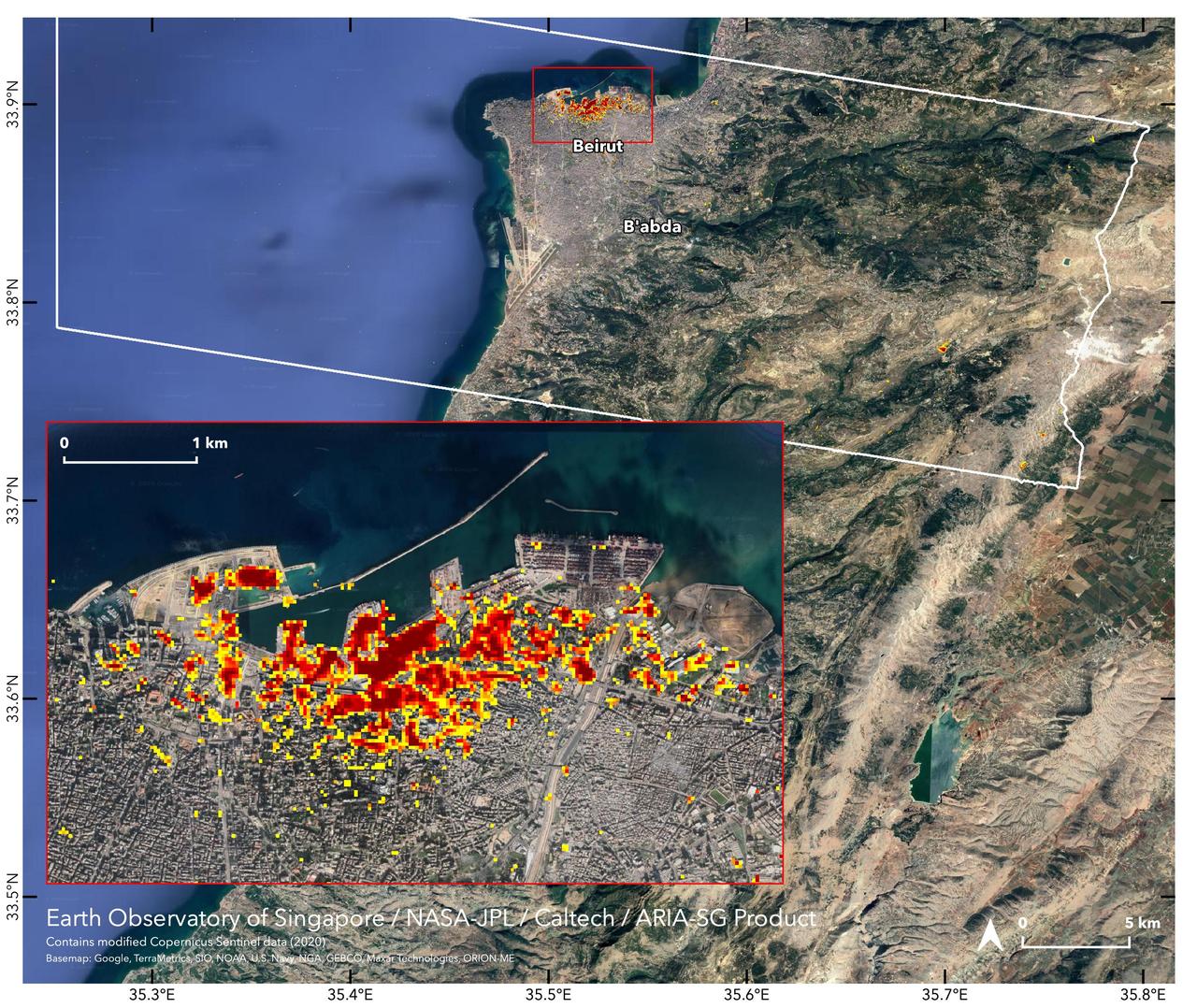
NASA's ARIA team, in collaboration with the Earth Observatory of Singapore, used satellite data to map the extent of likely damage following a massive explosion in Beirut. Dark red pixels represent the most severe damage. Areas in orange are moderately damaged, and areas in yellow are likely to have sustained somewhat less damage. Each colored pixel represents an area of 30 meters (33 yards). https://photojournal.jpl.nasa.gov/catalog/PIA23692
CAPE CANAVERAL, Fla. – Crews remove bricks from the damaged walls of the flame trench on Launch Pad 39A at NASA's Kennedy Space Center. Damage to the trench occurred during the launch of Discovery on the STS-124 mission. A 75- by 20-foot section of the east wall was destroyed and debris scattered as far as the pad perimeter fence. Repairs are expected to be completed before the targeted Oct. 8 launch of Atlantis on the STS-125 mission. Photo credit: NASA/Jack Pfaller
CAPE CANAVERAL, Fla. – Crews remove bricks from the damaged walls of the flame trench on Launch Pad 39A at NASA's Kennedy Space Center. Damage to the trench occurred during the launch of Discovery on the STS-124 mission. A 75- by 20-foot section of the east wall was destroyed and debris scattered as far as the pad perimeter fence. Repairs are expected to be completed before the targeted Oct. 8 launch of Atlantis on the STS-125 mission. Photo credit: NASA/Jack Pfaller
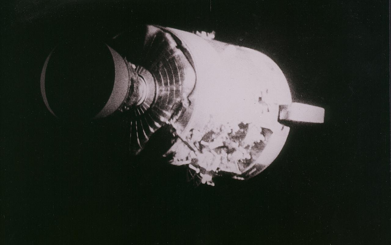
Apollo 13 onboard photo: This view of the severely damaged Apollo 13 Service Module was photographed from the Lunar Module/Command Module following the jettison of the Service Module. As seen here, an entire panel of the Service Module was blown away by the apparent explosion of oxygen tank number two located in Sector 4 of the Service Module. Two of the three fuel cells are visible just forward (above) the heavily damaged area. Three fuel cells, two oxygen tanks, and two hydrogen tanks, are located in Sector 4. The damaged area is located above the S-band high gain anterna. Nearest the camera is the Service Propulsion System (SPS) engine and nozzle. The damage to the Service Module caused the Apollo 13 crewmen to use the Lunar Module as a lifeboat. The Lunar Module was jettisoned by the Command Module just prior to Earth re-entry.
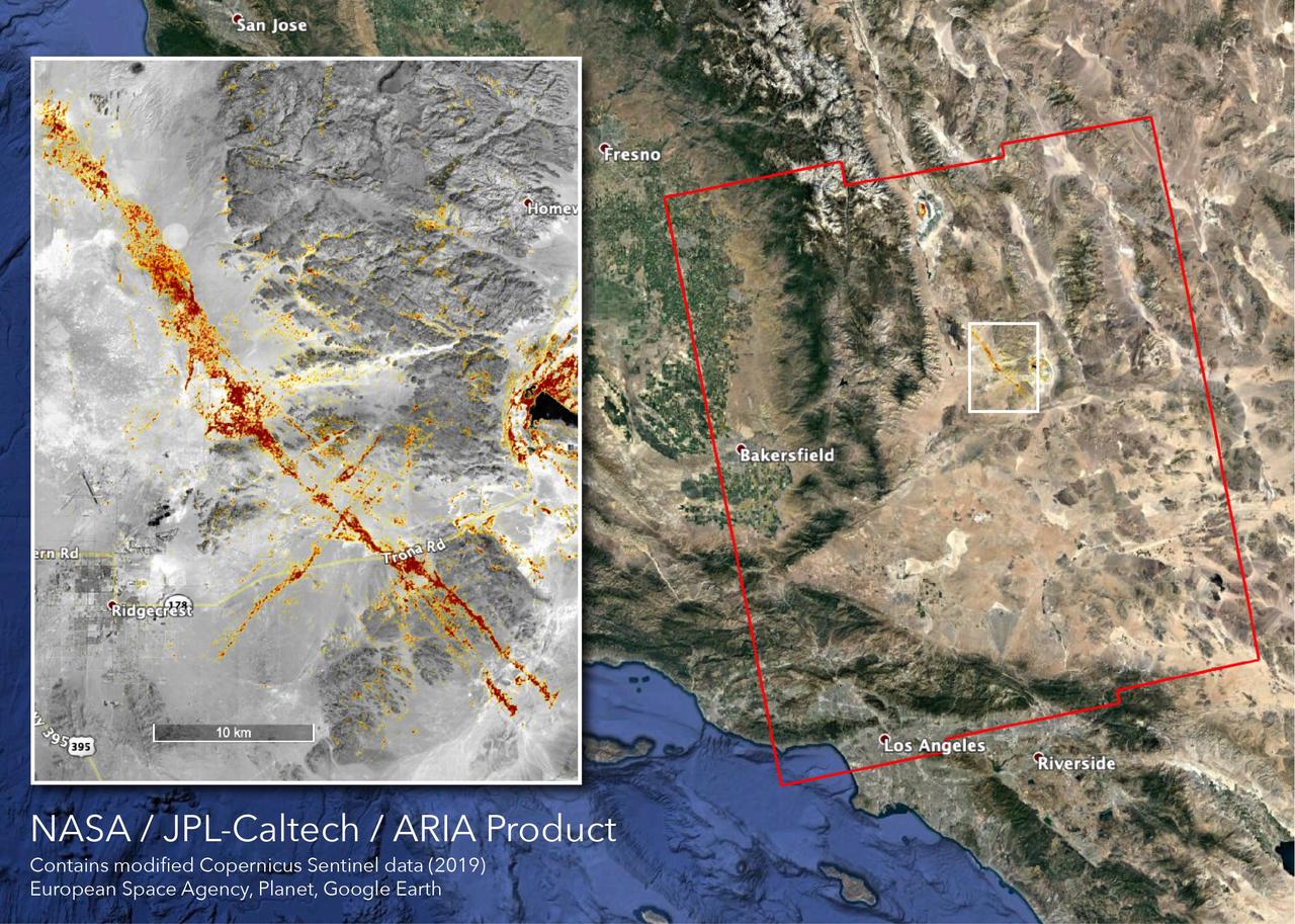
The Advanced Rapid Imaging and Analysis (ARIA) team at NASA's Jet Propulsion Laboratory in Pasadena, California, created this map depicting areas that are likely damaged as a result of the recent major earthquakes in Southern California. The color variation from yellow to red indicates increasingly more significant surface change, or damage. The map covers an area of 155 by 186 miles (250 by 300 kilometers), shown by the large red polygon. Each pixel measures about 33 yards (30 meters) across. To make the map, the team used synthetic aperture radar (SAR) images from the European Space Agency's Copernicus Sentinel-1 satellites from before and after the sequence of quakes — July 4, 2019 and July 10, 2019 respectively. The map may be less reliable over vegetated areas but can provide useful guidance in identifying damaged areas. https://photojournal.jpl.nasa.gov/catalog/PIA23354
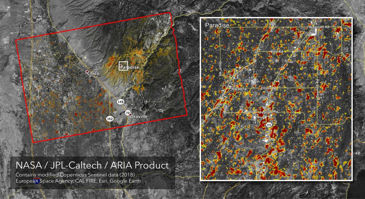
The Advanced Rapid Imaging and Analysis (ARIA) team at NASA's Jet Propulsion Laboratory in Pasadena, California, created this Damage Proxy Map (DPM) depicting areas of Northern California that are likely damaged (shown by red and yellow pixels) as a result of the Camp Fire. The map is derived from synthetic aperture radar (SAR) images from the Copernicus Sentinel-1 satellites, operated by the European Space Agency (ESA). The pre-event images were taken before (November 4, 2018) and the post-event image was acquired during the fire (6pm November 16, 2018, both local time). https://photojournal.jpl.nasa.gov/catalog/PIA22819
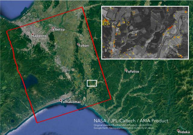
The Advanced Rapid Imaging and Analysis (ARIA) team at NASA's Jet Propulsion Laboratory in Pasadena, California, and Caltech, also in Pasadena, created this Damage Proxy Map (DPM) depicting areas in the southwestern part of Hokkaido, Japan, that are likely damaged as a result of the M6.6 September 5 earthquake in 2018 (shown by red and yellow pixels). The map is derived from synthetic aperture radar (SAR) images from the ALOS-2 satellites, operated by Japan Aerospace Exploration Agency (JAXA). The images were taken before and after the earthquake -- August 23 and September 6, respectively. The map covers an area of 70 by 57 kilometers, shown by the large red polygon. Each pixel measures about 30 meters across. The color variation from yellow to red indicates increasingly more significant ground surface change. Preliminary validation was done by comparing with the high-resolution airborne optical imagery provided by the Geospatial Information Authority of Japan. This damage proxy map should be used as guidance to identify damaged areas, and may be less reliable over vegetated areas. For example, pixels over vegetated areas and farmlands may be false positives, and the lack of colored pixels over vegetated areas does not necessarily mean no damage. The DPM was created by the NASA-JPL/Caltech ARIA team, and the ALOS-2 data were provided by JAXA. The algorithm development was carried out at JPL under a contract with NASA. https://photojournal.jpl.nasa.gov/catalog/PIA22696
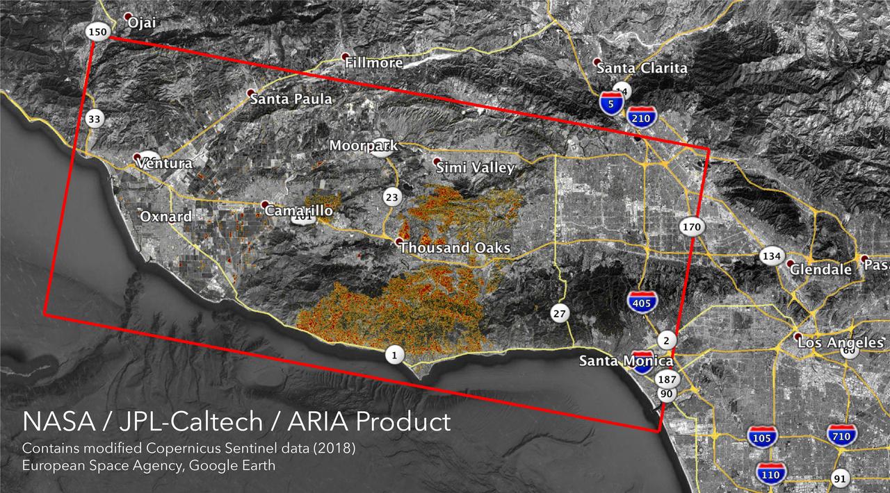
The Advanced Rapid Imaging and Analysis (ARIA) team at NASA's Jet Propulsion Laboratory in Pasadena, California, created these Damage Proxy Maps (DPMs) depicting areas in California likely damaged by the Woolsey and Camp Fires. They are derived from synthetic aperture radar (SAR) images from the Copernicus Sentinel-1 satellites, operated by the European Space Agency (ESA). The pre-event images for the Woolsey Fire in Southern California were taken before the fire on Oct. 30, 2018 and the post-event image was acquired during the fire on Nov. 11, 2018. The map covers an area of 50 miles x 25 miles (80 km x 40 km), indicated with the big red polygon. Each pixel measures about 33 yards x 33 yards (30 m x 30 m). The color variation from yellow to red indicates increasingly more significant ground surface change. The pre-event images for the Camp Fire in Northern California were taken on Nov. 4, 2018 and the post-event images were acquired during the fire on Nov. 10, 2018. The map covers an area of 55 miles x 48 miles (88 km x 77 km). As in the previous image, each pixel measures about 33 yards x 33 yards (30 m x 30 m). The color variation from yellow to red indicates increasingly more significant ground surface change. Preliminary validation for both maps was done by comparing approximate location data to Google's Crisismap. These damage proxy maps can be used as guidance to identify damaged areas with the understanding that they may be less reliable over vegetated areas including farmlands. For example, the scattered single colored pixels over vegetated areas may be false positives, and the lack of colored pixels over vegetated areas does not necessarily mean no damage. https://photojournal.jpl.nasa.gov/catalog/PIA22816
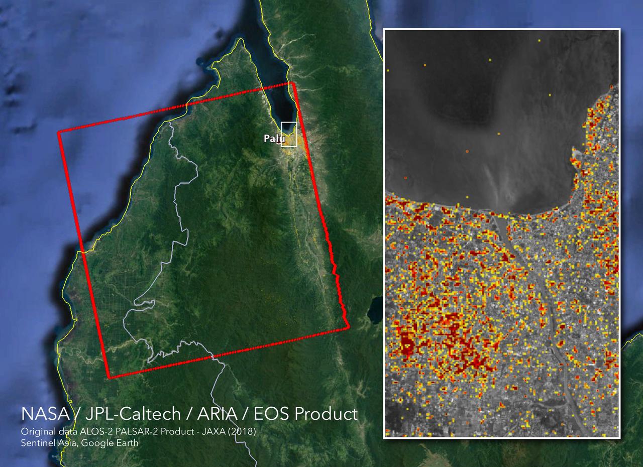
The Advanced Rapid Imaging and Analysis (ARIA) team at NASA's Jet Propulsion Laboratory in Pasadena, California, and Caltech, also in Pasadena, created this Damage Proxy Map (DPM) depicting areas in Central Sulawesi, Indonesia, including the city of Palu, that are likely damaged (shown by red and yellow pixels) as a result of the magnitude 7.5 September 28, 2018 earthquake. The map is derived from synthetic aperture radar (SAR) images from the ALOS-2 satellite, operated by Japan Aerospace Exploration Agency (JAXA). The images were taken before (Aug. 8, 2018) and after (Oct. 3, 2018) the earthquake. The map covers an area of 42 by 44 miles (67 by 70 kilometers), shown by the large red polygon. Each pixel measures about 33 yards (30 meters) across. The color variation from yellow to red indicates increasingly more significant ground surface change. Preliminary validation was done in collaboration with the Earth Observatory of Singapore by comparing with local media information and photos. This damage proxy map should be used as guidance to identify damaged areas, and may be less reliable over vegetated areas. For example, the scattered single colored pixels over vegetated areas may be false positives, and the lack of colored pixels over vegetated areas does not necessarily mean no damage. The DPM was created by the NASA-JPL/Caltech ARIA team, and the ALOS-2 data were provided by JAXA. The Earth Observatory of Singapore coordinated with the Sentinel Asia to timely task the ALOS-2 satellite. The algorithm development was carried out at JPL under a contract with NASA. https://photojournal.jpl.nasa.gov/catalog/PIA22746

The Advanced Rapid Imaging and Analysis (ARIA) team at NASA's Jet Propulsion Laboratory in Pasadena, California, and Caltech, also in Pasadena, created this Damage Proxy Map (DPM) depicting areas in the northeastern part of Lombok Island, Indonesia, that are likely damaged (shown by red and yellow pixels) as a result of the major earthquake sequence (including the M6.4 July 29, the M6.9 August 5, the M5.9 August 9, and the M6.4 August 18 earthquakes) in 2018. The map is derived from synthetic aperture radar (SAR) images from the ALOS-2 satellites, operated by Japan Aerospace Exploration Agency (JAXA). The images were taken before the (May 13, 2018 00:30) and after the (August 19, 2018 00:30, both local time) earthquakes. The map covers an area of 73 by 70 kilometers, shown by the large red polygon. Each pixel measures about 30 meters across. The color variation from yellow to red indicates increasingly more significant ground surface change. Preliminary validation was done by comparing with the DigitalGlobe's high-resolution optical satellite imagery. This damage proxy map should be used as guidance to identify damaged areas, and may be less reliable over vegetated areas. For example, the scattered single colored pixels over vegetated areas may be false positives, and the lack of colored pixels over vegetated areas does not necessarily mean no damage. The DPM was created by the NASA-JPL/Caltech ARIA team, and the ALOS-2 data were provided by JAXA. The Earth Observatory of Singapore coordinated with the Sentinel Asia to timely task the ALOS-2 satellite. The algorithm development was carried out at JPL under a contract with NASA. https://photojournal.jpl.nasa.gov/catalog/PIA22495

Interstate 10 across Pensacola Bay, Florida was severely damaged by Hurricane Ivan. This image was acquired by NASA Terra satellite on September 21, 2004.
AS13-58-8464 (17 April 1970) --- This view of the severely damaged Apollo 13 Service Module (SM) was photographed from the Lunar Module/Command Module (LM/CM) following SM jettisoning. Nearest the camera is the Service Propulsion System (SPS) engine and nozzle. An entire SM panel was blown away by the apparent explosion of oxygen tank number two located in Sector 4 of the SM. The apparent rupture of the oxygen tank caused the Apollo 13 crew men to use the Lunar Module (LM) as a "lifeboat".
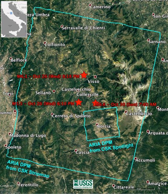
Damage Proxy Map (DPM) v0.5, derived from the Italian Space Agency's COSMO-SkyMed Spotlight synthetic aperture radar (SAR) data acquired from an ascending orbit, covering an area of 6.2-by-6.2 miles (10-by-10 kilometers), centered at Norcia, Italy. Red pixels (pixel size about 16 feet, or 5 meters)represent areas of potential damage due to the Magnitude 6.6 Oct 30, 2016, Central Italy earthquakes, as well as ground surface change during the time period Oct. 30, 2016 -- Oct. 31, 2016. The color variation from yellow to red indicate increasingly more significant ground surface change. Preliminary validation was carried out by comparing with high-resolution pre- and post-event optical imagery acquired by DigitalGlobe's WorldView satellites, and a damage map produced by the European Commission Copernicus Emergency Management Service based upon visual inspection of high-resolution pre- (Orthophoto) and post-event (Pleiades-1) optical imagery. This DPM provides broad geographic coverage of the earthquake's impact in the region. Areas that fall in radar shadow and layover were masked out. The DPM should be used as guidance to identify damaged areas, and may be less reliable over vegetated areas. http://photojournal.jpl.nasa.gov/catalog/PIA15374
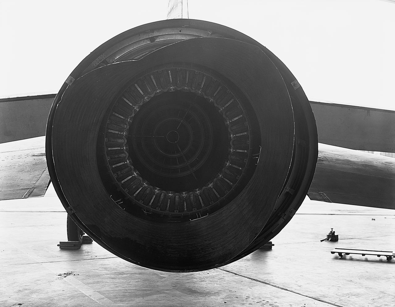
Exhaust cone damage.
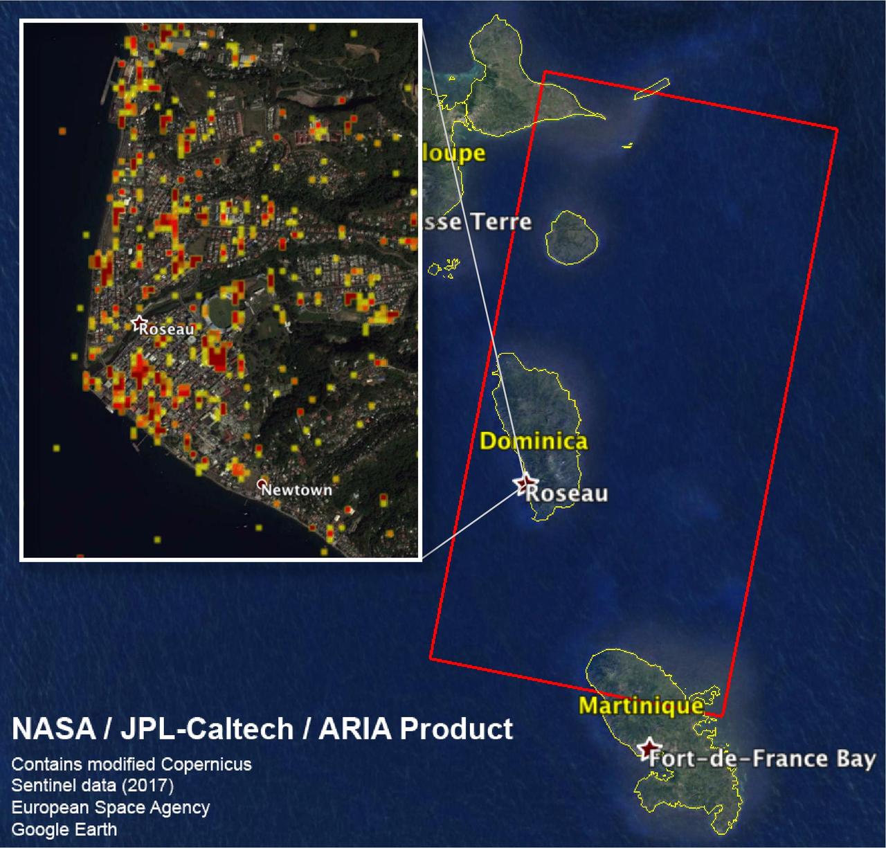
The Advanced Rapid Imaging and Analysis (ARIA) team at NASA's Jet Propulsion Laboratory in Pasadena, California, and Caltech, also in Pasadena, created this Damage Proxy Map (DPM) depicting areas including the Commonwealth of Dominica, that are likely damaged (shown by red and yellow pixels) as a result of Hurricane Maria (a Category 5 storm at landfall in Dominica on Sept. 18, 2017). The map is derived from synthetic aperture radar (SAR) images from the Copernicus Sentinel-1 satellites, operated by the European Space Agency (ESA). The images were taken before (March 27, 2017) and after (Sept. 23, 2017) the landfall of the storm. The map covers the area within the large red polygon, which measures 53 by 106 miles (85 by 170 kilometers). Each pixel measures about 98 feet (30 meters) across. The color variation from yellow to red indicates increasingly more significant ground surface change. Preliminary validation was done by comparing the data to a crowdsourced map by Clemson Center for Geospatial Technologies and optical satellite imagery feom DigitalGlobe. This damage proxy map should be used as guidance to identify damaged areas, and may be less reliable over vegetated areas. Sentinel-1 data were accessed through the Copernicus Open Access Hub. The image contains modified Copernicus Sentinel data (2017), processed by ESA and analyzed by the NASA/JPL-Caltech ARIA team. This research was carried out at JPL under a contract with NASA. https://photojournal.jpl.nasa.gov/catalog/PIA22037
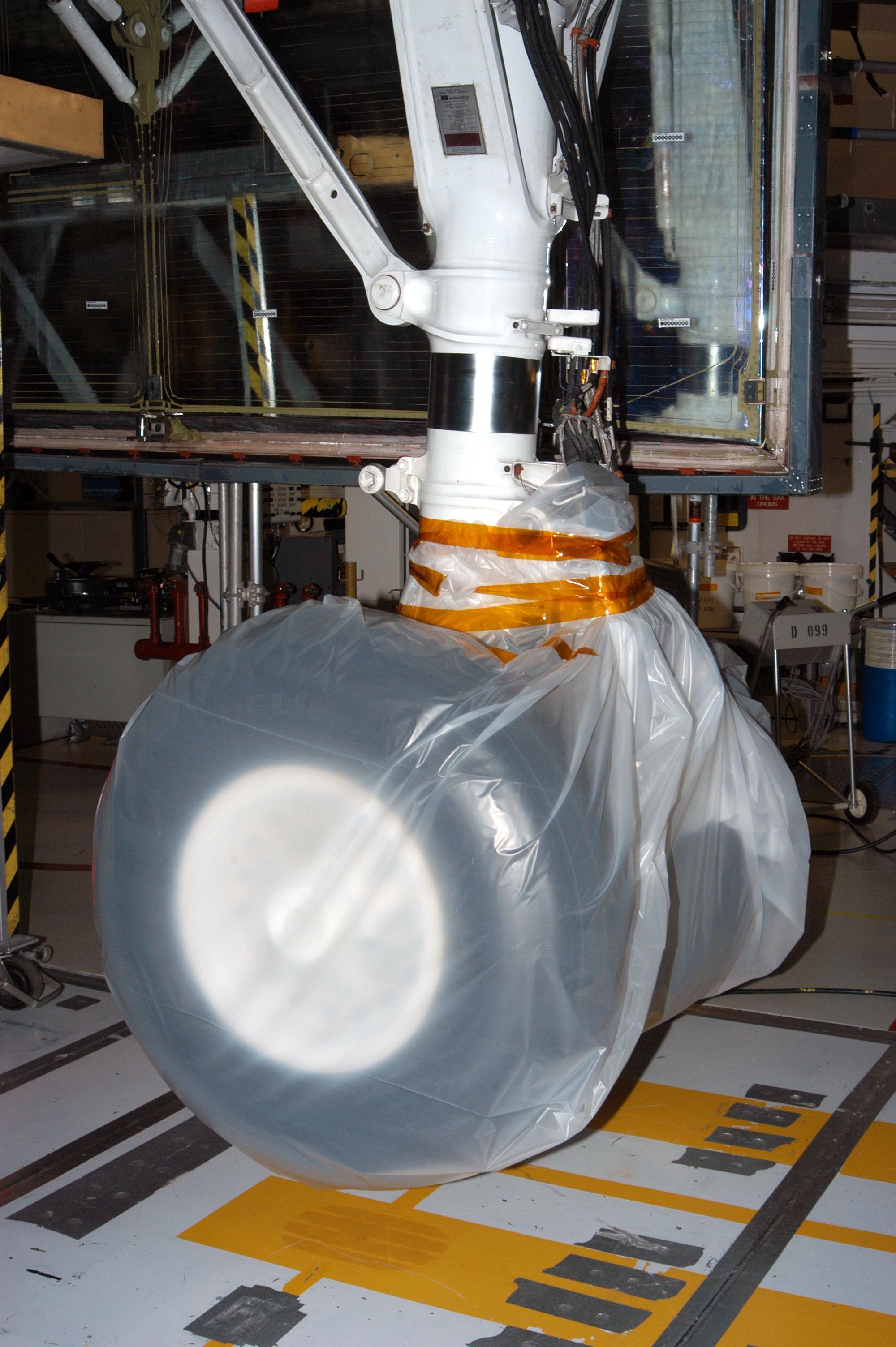
KENNEDY SPACE CENTER, FLA. - In the Orbiter Processing Facility, the wheel on Atlantis is covered in plastic that protected it from possible damage by Hurricane Jeanne. The storm ravaged Central Florida for 21 hours as it crossed the shoreline on the east coast Sept. 25-26. This was the fourth hurricane in 6 weeks to batter the state.
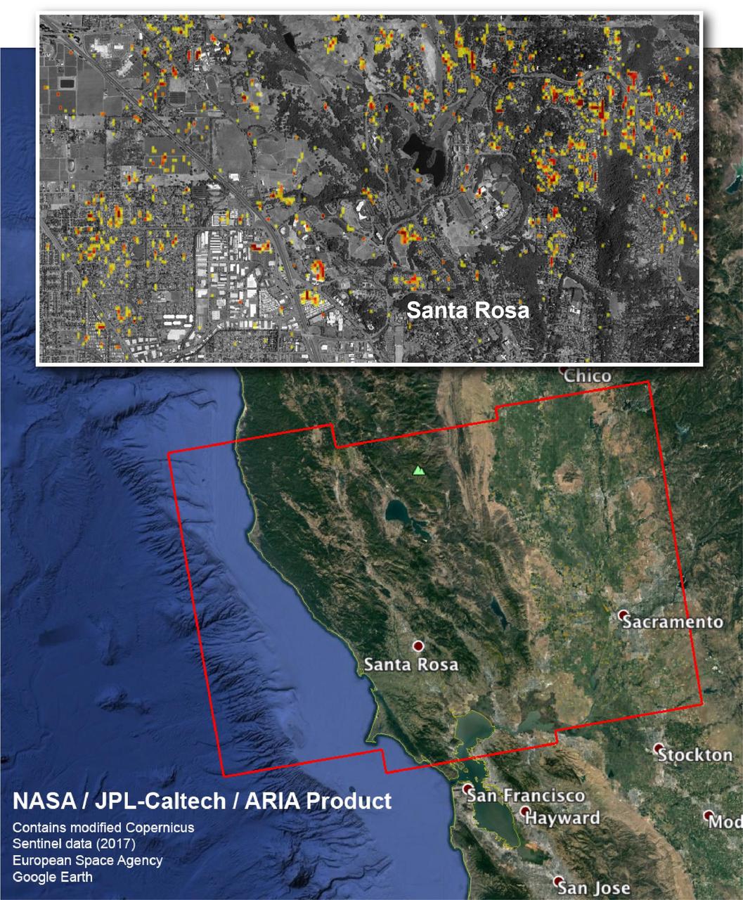
The Advanced Rapid Imaging and Analysis (ARIA) team at NASA's Jet Propulsion Laboratory in Pasadena, California, and Caltech, also in Pasadena, created this Damage Proxy Map depicting areas in Northern California that are likely damaged (shown by red and yellow pixels) as a result of the region's current outbreak of wildfires. The map is derived from synthetic aperture radar (SAR) images from the Copernicus Sentinel-1 satellites, operated by the European Space Agency (ESA). The images were taken before (Sep. 27, 2017, 7 p.m. PDT) and after (Oct. 9, 2017, 7 p.m. PDT) the onset of the fires. The map has been provided to various agencies to aid in the wildfire response. The map covers the area within the large red polygon, and measures 155 by 106 miles (250 by 170 kilometers). The illustrative figure from the map depicted in the inset shows damage in the city of Santa Rosa. Each pixel in the Damage Proxy Map measures about 98 feet (30 meters) across. The color variation from yellow to red indicates increasingly more significant ground surface change. Preliminary validation was done by comparing to optical satellite imagery from DigitalGlobe. This Damage Proxy Map should be used as guidance to identify damaged areas, and may be less reliable over vegetated areas. Sentinel-1 data were accessed through the Copernicus Open Access Hub. The image contains modified Copernicus Sentinel data (2017), processed by ESA and analyzed by the NASA-JPL/Caltech ARIA team. This research was carried out at JPL under a contract with NASA. https://photojournal.jpl.nasa.gov/catalog/PIA22048
AS13-58-8458 (17 April 1970) --- This view of the severely damaged Apollo 13 Service Module (SM) was photographed from the Lunar Module/Command Module (LM/CM) following SM jettisoning. An entire SM panel was blown away by the apparent explosion of oxygen tank number two. Two of the three fuel cells are visible at the forward portion of the opening. The hydrogen tanks are located in Sector 4 of the Apollo 13 SM. The apparent rupture of the oxygen tank caused the Apollo 13 crew members to use the LM as a "lifeboat." The LM was jettisoned just prior to Earth re-entry by the CM.
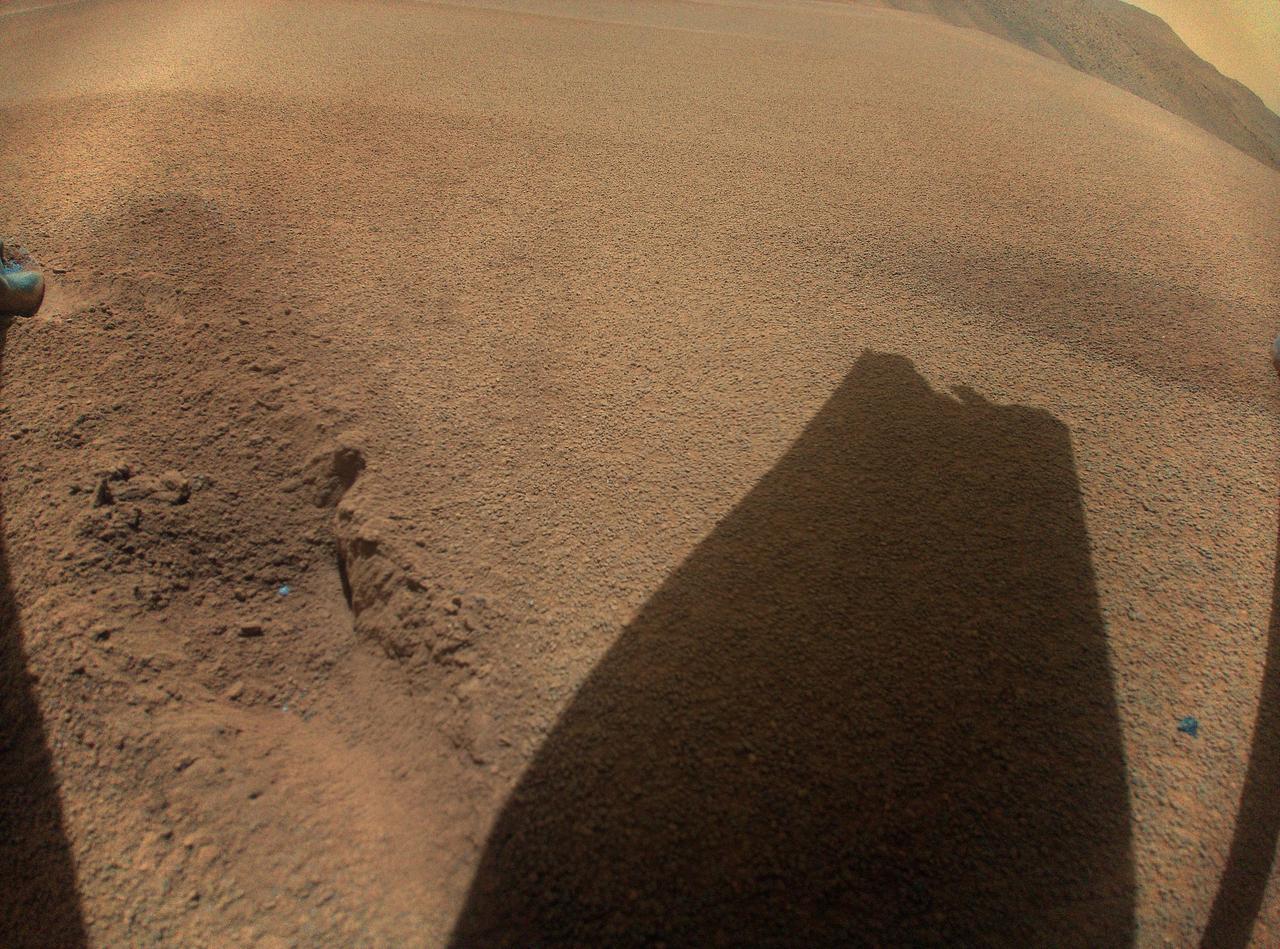
After its 72nd flight on Jan. 18, 2024, NASA's Ingenuity Mars Helicopter captured this color image showing the shadow of a rotor blade damaged during a rough landing. https://photojournal.jpl.nasa.gov/catalog/PIA26243
KENNEDY SPACE CENTER, FLA. - In this aerial view, damage is apparent on the roof of the Apollo/Saturn V Building at KSC from Hurricane Jeanne. A category 3 storm, Jeanne barreled through Central Florida Sept. 25-26, the fourth hurricane in 6 weeks to batter the state.
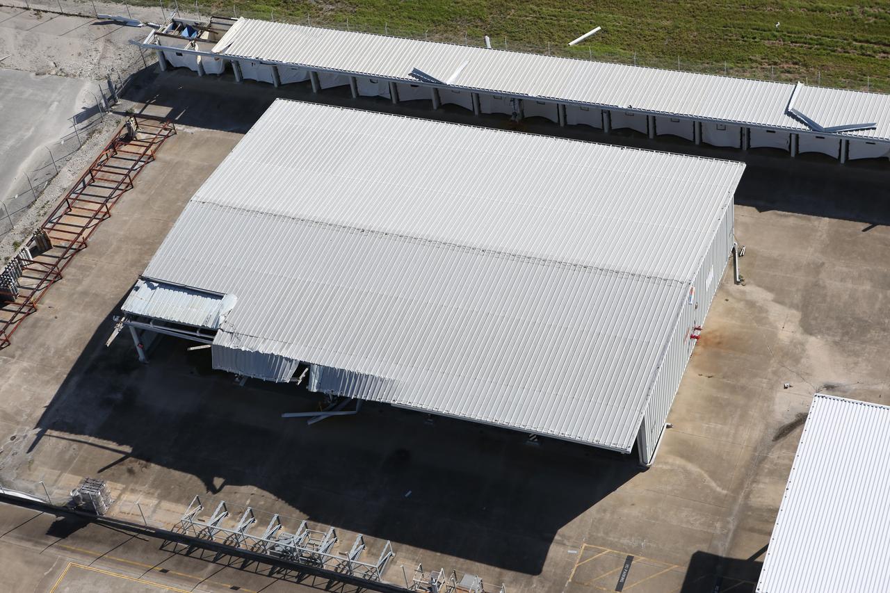
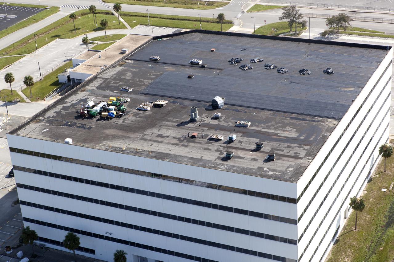
KENNEDY SPACE CENTER, FLA. - An aerial view of the Vehicle Assembly Building at KSC shows damage to the roof inflicted by both Hurricane Frances and the category 3 Hurricane Jeanne. The latter storm barreled through Central Florida Sept. 25-26, the fourth hurricane in 6 weeks to batter the state.
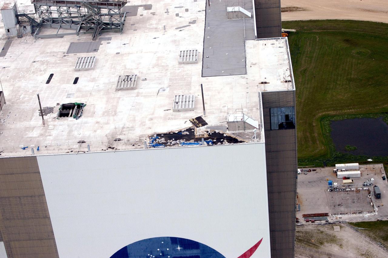
KENNEDY SPACE CENTER, FLA. - An aerial view of the Vehicle Assembly Building at KSC shows damage to the roof inflicted by both Hurricane Frances and the category 3 Hurricane Jeanne. The latter storm barreled through Central Florida Sept. 25-26, the fourth hurricane in 6 weeks to batter the state.