
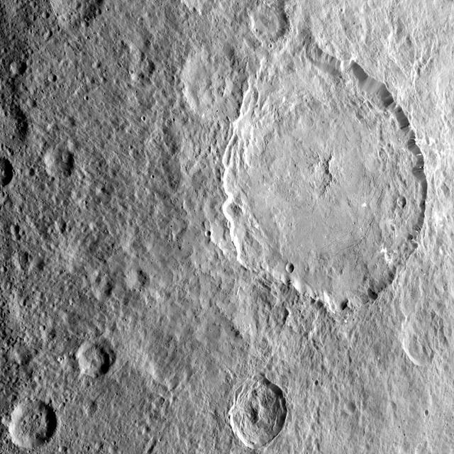
Dantu Crater on Ceres, at top center, is featured in this image from NASA's Dawn spacecraft. Dantu, whose diameter is 77 miles (124 kilometers), has a central complex of mountain peaks. Small patches of bright material can be seen in some places along the crater walls and floor. A small crater (4-miles, 6-kilometers wide) located around the 5 o'clock position within Dantu is called Centeotl. This crater is named for the Mexican deity of maize and agriculture. Dawn took this image on Oct. 21, 2016, from its second extended-mission science orbit (XMO2), at a distance of about 920 miles (1,480 kilometers) above the surface. The image resolution is about 460 feet (140 meters) per pixel. http://photojournal.jpl.nasa.gov/catalog/PIA21242

This image from NASA's Dawn spacecraft shows Dantu Crater, which is 78 miles (126 kilometers) across. Its shape is reminiscent of Occator Crater -- in particular, they both have shallow floors and central pits. This suggests melting and possibly some hydrothermal activity occurred following impact that formed Dantu. Part of the energy generated by the impact would have been turned into heat. The relatively warm temperatures found at the low latitudes of Dantu and Occator make it easier for Ceres' ice-rich material to melt as a consequence of impact-generated heat. The unnamed crater seen below Dantu in this image is smaller and has a much rougher floor. This is because the smaller impact event would not have generated as much heat. The numerous bright spots found across the crater suggest bright material may be just below the surface, exposed through small impacts and landslides. Ejected material from Dantu extends up to Kerwan crater, with a dark color reminiscent of material that came from Occator. Dantu was named for the Ghanaian god associated with the planting of the corn. This picture was taken by the Dawn framing camera on September 25, 2015, from 915 miles (1,470 kilometers) altitude. The center coordinates of this picture are 22 degrees north latitude, 133 degrees east longitude. https://photojournal.jpl.nasa.gov/catalog/PIA21412
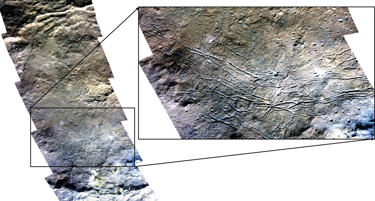
This image highlights the complex central construct and concentric fractures in the large (78 miles, 126 kilometers) Dantu Crater. It was obtained by NASA's Dawn spacecraft on September 1, 2018 from an altitude of about 1335 miles (2150 kilometers). NASA announced the conclusion of Dawn's mission operations was Oct. 31, 2018, when the spacecraft depleted its hydrazine. The center of Dantu Crater is located at about 24.3 degrees north latitude and 138.2 degrees east longitude. Dantu Crater is named after the Ghanan god associated with the planting of the corn. https://photojournal.jpl.nasa.gov/catalog/PIA22985
This color mosaic of Dantu Crater was obtained by NASA's Dawn spacecraft on May 23, 2018 from an altitude of about 305 miles (490 kilometers). The center of Dantu Crater is located at about 24 degrees north in latitude and 138 degrees east in longitude. https://photojournal.jpl.nasa.gov/catalog/PIA22471
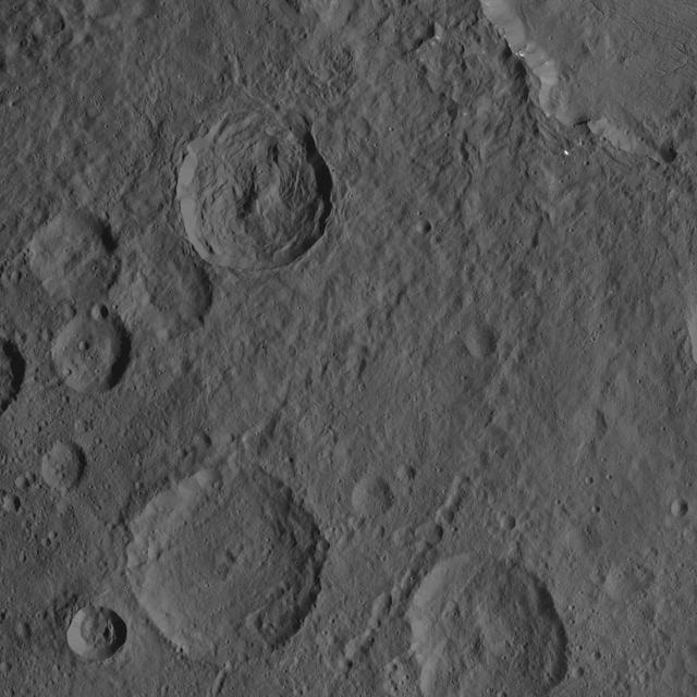
This scene captured by NASA Dawn spacecraft on Oct. 21, 2016, from Ceres northern hemisphere shows part of the rim of Dantu Crater, at top right. Rao Crater is the largest crater in the bottom left corner of the image. Dawn took this image on Oct. 21, 2016, from its second extended-mission science orbit (XMO2), at a distance of about 920 miles (1,480 kilometers) above the surface. The image resolution is about 460 feet (140 meters) per pixel. http://photojournal.jpl.nasa.gov/catalog/PIA21243
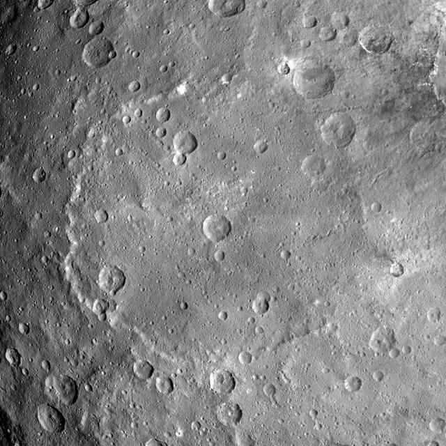
The rim of Dantu Crater (78 miles, 125 kilometers wide) is seen in this view of Ceres from NASA's Dawn spacecraft. Dawn took this image on June 2, 2016, from its low-altitude mapping orbit, at a distance of about 240 miles (385 kilometers) above the surface. The image resolution is 120 feet (35 meters) per pixel. http://photojournal.jpl.nasa.gov/catalog/PIA20938

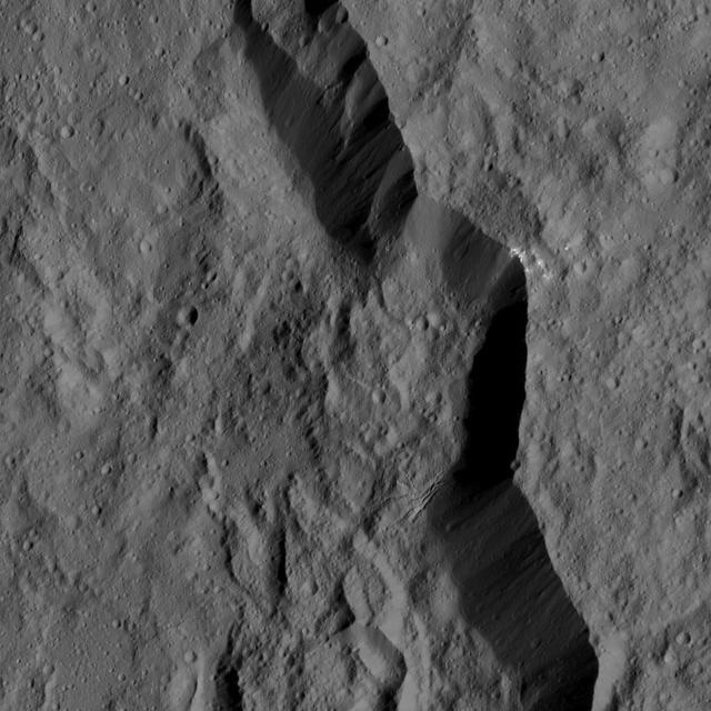
The fractured floor of Dantu Crater on Ceres is seen in this image from NASA's Dawn spacecraft. Similar fractures are seen in Tycho, one of the youngest large craters on Earth's moon. This cracking may have resulted from the cooling of impact melt, or when the crater floor was uplifted after the crater formed. Dantu was imaged earlier in Dawn's science mission at Ceres -- during Survey orbit (see PIA19609) and from the high altitude mapping orbit, or HAMO (see PIA19993). Dawn took this image on Dec. 21 from its low-altitude mapping orbit (LAMO) at an approximate altitude of 240 miles (385 kilometers) above Ceres. The image resolution is 120 feet (35 meters) per pixel. http://photojournal.jpl.nasa.gov/catalog/PIA20193

This image, taken by NASA's Dawn spacecraft, shows Dantu crater on dwarf planet Ceres from an altitude of 2,700 miles (4,400 kilometers). The image, with a resolution of 1,400 feet (410 meters) per pixel, was taken on June 24, 2015. Dantu, at bottom center, is about 75 miles (120 kilometers) across and 3 miles (5 kilometers) deep, has small patches of bright material sprinkled around it. http://photojournal.jpl.nasa.gov/catalog/PIA19609

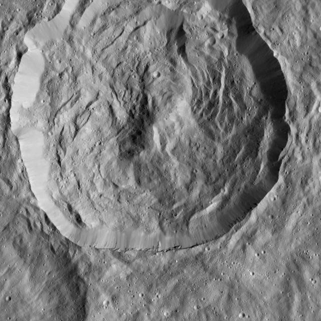
This view shows peaks in the center of Dantu Crater (78 miles, 125 kilometers) on Ceres. Dantu is named for a Ghanan god associated with the planting of corn. NASA's Dawn spacecraft took this image on June 3, 2016, from its low-altitude mapping orbit, at a distance of about 240 miles (385 kilometers) above the surface. The image resolution is 120 feet (35 meters) per pixel. http://photojournal.jpl.nasa.gov/catalog/PIA20871
Dantu crater on Ceres, seen here at left, reveals structures hinting at tectonic processes that formed the dwarf planet's surface. Linear structures are spread over the crater floor. Outside the crater's rim, the occurrence of linear structures continues the in form of scarps (linear, cliff-like slopes) and ridges. Dantu's diameter is 78 miles (125 kilometers). The image was taken by NASA's Dawn spacecraft on Oct. 3, 2015, from an altitude of 915 miles (1,470 kilometers). It has a resolution of 450 feet (140 meters) per pixel. The image is located at 31 degrees north latitude, 149 degrees east longitude. http://photojournal.jpl.nasa.gov/catalog/PIA20122

This view from NASA's Dawn spacecraft captures the southeast rim of Dantu Crater. Bright material can be seen in some places along the walls. A network of fractures in the crater floor is visible at upper right. Dawn previously imaged the whole of Dantu from a higher-altitude mapping orbit (see PIA19993). The image is centered at approximately 20 degrees north latitude, 142 degrees east longitude. Dawn captured the scene on Dec. 20, 2015 from its low-altitude mapping orbit (LAMO), at an approximate altitude of 240 miles (385 kilometers) above Ceres. The image resolution is 120 feet (35 meters) per pixel. http://photojournal.jpl.nasa.gov/catalog/PIA20300

This image, taken on June 9, 2015 by NASA Dawn spacecraft, shows Dantu crater on Ceres, at upper right, from an altitude of 2,700 miles 4,400 kilometers. North on Ceres is toward upper right. http://photojournal.jpl.nasa.gov/catalog/PIA19620
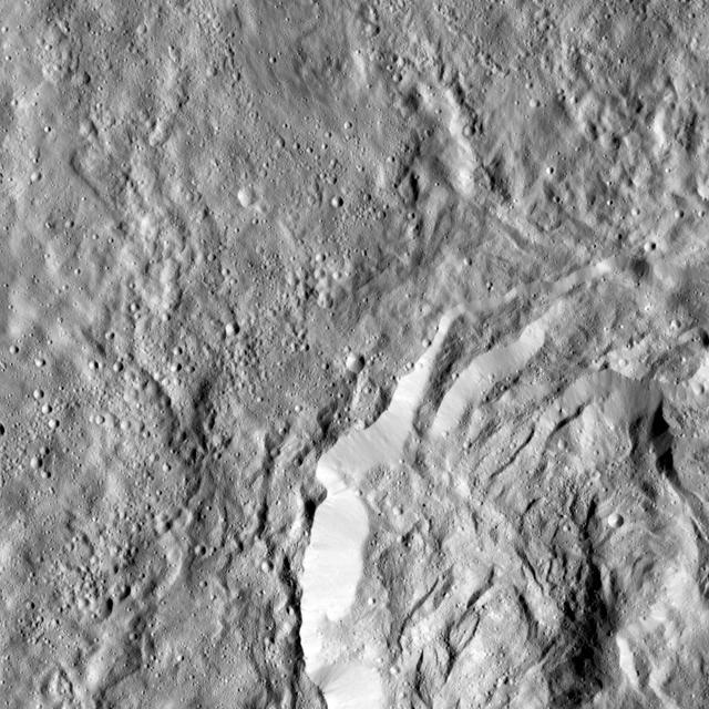
This image obtained by NASA's Dawn spacecraft shows a field of small craters next to Kokopelli Crater, seen at bottom right in this image, on dwarf planet Ceres. The small craters overlay a smooth, wavy material that represents ejecta from nearby Dantu Crater. The small craters were formed by blocks ejected in the Dantu impact event, and likely from the Kokopelli impact as well. Kokopelli is named after the fertility deity who presides over agriculture in the tradition of the Pueblo people from the southwestern United States. The crater measures 21 miles (34 kilometers) in diameter. Dawn took this image during its first extended mission on August 11, 2016, from its low-altitude mapping orbit, at about 240 miles (385 kilometers) above the surface. The center coordinates of this image are 20 degrees north latitude, 123 degrees east longitude. https://photojournal.jpl.nasa.gov/catalog/PIA21915
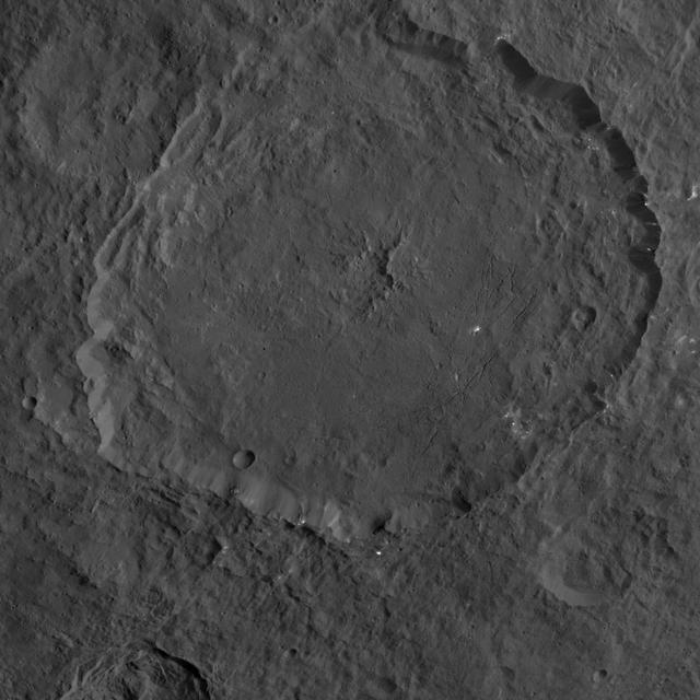
This image, taken by NASA's Dawn spacecraft, shows a portion of the northern hemisphere of dwarf planet Ceres from an altitude of 915 miles (1,470 kilometers). The image was taken on Sept. 25, 2015, and has a resolution of 450 feet (140 meters) per pixel. Dantu crater, named for the Ghanan god associated with the planting of corn, is featured in this image. Its diameter is 77.1 miles (124 kilometers). http://photojournal.jpl.nasa.gov/catalog/PIA19993

This view from NASA's Dawn spacecraft captures the central complex of mountain peaks within Dantu Crater on Ceres. A patch of bright material is visible near lower right. The image is centered at approximately 23 degrees north latitude, 139 degrees east longitude. Dawn captured the scene on Dec. 21, 2015 from its low-altitude mapping orbit (LAMO), at an approximate altitude of 240 miles (385 kilometers) above Ceres. The image resolution is 120 feet (35 meters) per pixel. http://photojournal.jpl.nasa.gov/catalog/PIA20303

This image from NASA's Dawn spacecraft highlights Axomama Crater, the small crater shown to the right of center. It is 3 miles (5 kilometers) in diameter and located just inside the western rim of Dantu Crater. Axomama is one of the newly named craters on Ceres. Its sharp edges indicate recent emplacement by a small impact. This picture also shows details on the floor of Dantu, which comprises most of the image. The many fractures and the central pit (see also PIA20303) are reminiscent of Occator Crater and could point to a similar formation history, involving activity driven by the presence of liquid water in the subsurface. Axomama is named after the Incan goddess of potato, or "Potato-mother." NASA's Dawn spacecraft acquired this picture during its extended mission on July 24, 2016, from its low altitude mapping orbit at about 240 miles (385 kilometers) above the surface. The center coordinates of this image are 24 degrees north latitude, 131 degrees east longitude. https://photojournal.jpl.nasa.gov/catalog/PIA21908
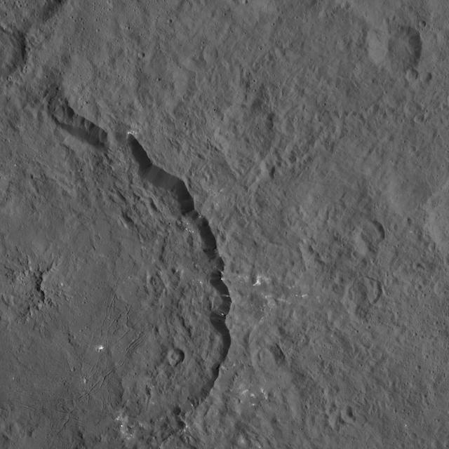
NASA's Dawn spacecraft viewed this Cerean crater, which is covered in ridges and steep slopes, called scarps on Dec. 23, 2015. These features likely resulted when the crater partly collapsed during its formation. The curvilinear nature of the scarps resembles those on the floor of Rheasilvia, the giant impact crater on Vesta, which Dawn orbited from 2011 to 2012. The 20-mile-wide (32-kilometer-wide) crater is located just west of the larger, named crater Dantu (see PIA20193), at northern mid-latitudes on Ceres. Both of these impact features were captured during Dawn's Survey orbit (see PIA19609). Dawn took this image from its low-altitude mapping orbit (LAMO) at an approximate altitude of 240 miles (385 kilometers) above Ceres. The image resolution is 120 feet (35 meters) per pixel. http://photojournal.jpl.nasa.gov/catalog/PIA20194
This image from NASA's Dawn spacecraft shows the largest crater on Ceres, called Kerwan. The crater has an appearance scientists refer to as "relaxed," meaning its sharp features have softened since Kerwan formed. Its overall shape looks something like a pancake, especially when viewed near Ceres' limb. The origin of its polygonal shape is not yet well understood; it might be due to large faults in the subsurface generated by other large impacts, as has been suggested for other craters. The smaller crater named Insitor sits in the center of Kerwan. The dark material seen at top right is ejecta from Dantu crater. At 174 miles (280 kilometers) wide, Kerwan is so large that it would have taken about 50 images at Dawn's low-altitude mapping orbit (called LAMO, at 240 miles or 385 kilometers altitude) to cover the crater from one side to the other. Kerwan was also too wide to fit within the camera's field of view at Dawn's high-altitude mapping orbit (called HAMO, at 915 miles, 1,470 kilometers). It fit nicely into this frame from Dawn's Survey phase (an altitude of 2,700 miles or 4,400 kilometers), taken shortly after the spacecraft entered orbit in 2015. Kerwan takes its name from the Hopi spirit of sprouting maize. This picture was obtained on June 12, 2015. Its center coordinates are 10.8 degrees south latitude, 123.9 degrees east longitude. https://photojournal.jpl.nasa.gov/catalog/PIA21411