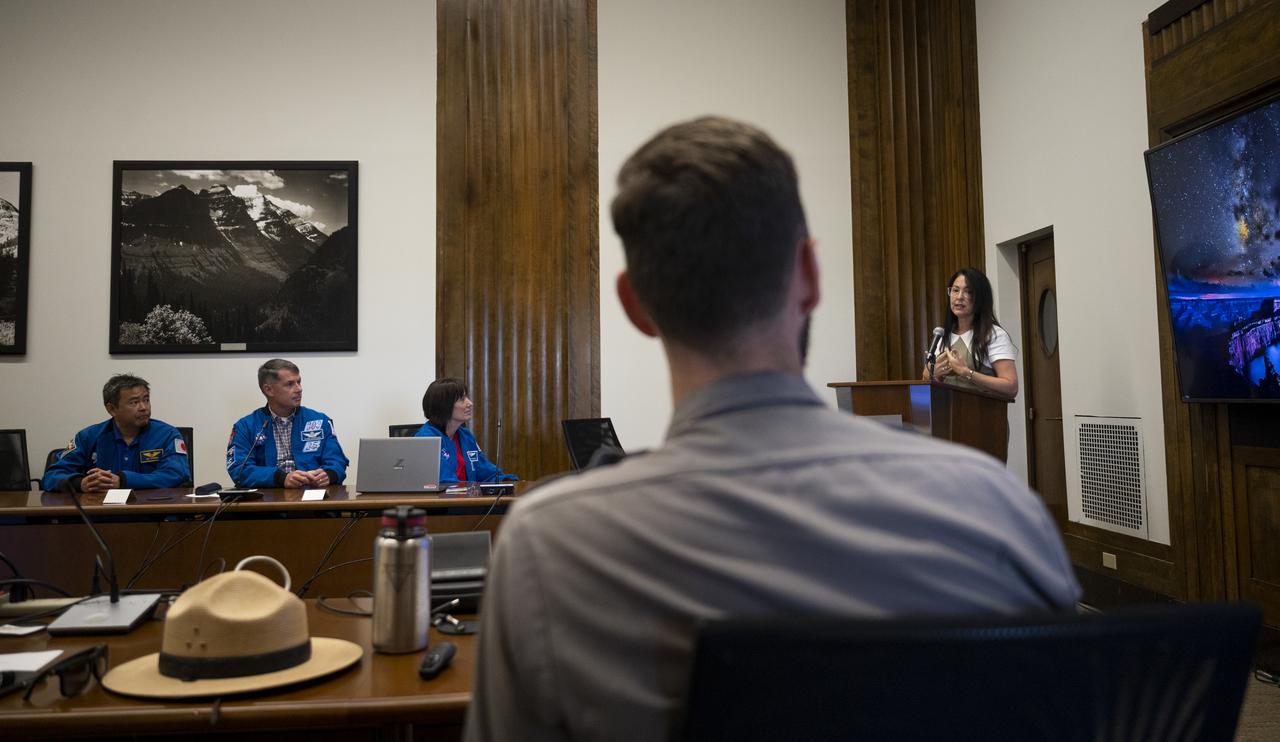
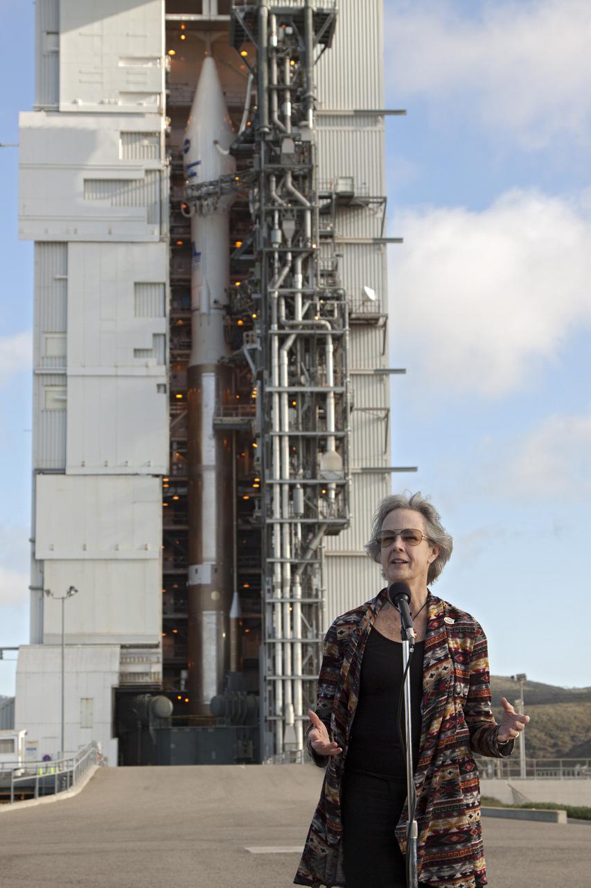
Shannon Estenoz, Assistant Secretary for Fish and Wildlife and Parks at the Department of the Interior, delivers remarks during a visit by NASA’s SpaceX Crew-2 astronauts with leadership and rangers who participate in the National Park Service’s astronomy and dark sky programs, Thursday, June 9, 2022 at the U.S. Department of the Interior in Washington, DC. NASA astronauts Shane Kimbrough and Megan McArthur, Japan Aerospace Exploration Agency (JAXA) astronaut Akihiko Hoshide, and ESA (European Space Agency) astronaut Thomas Pesquet completed the second crew rotation mission to the International Space Station as part of the agency’s Commercial Crew Program and spent 198 days aboard the orbiting laboratory as part of Expeditions 65 and 66. Photo Credit: (NASA/Joel Kowsky)
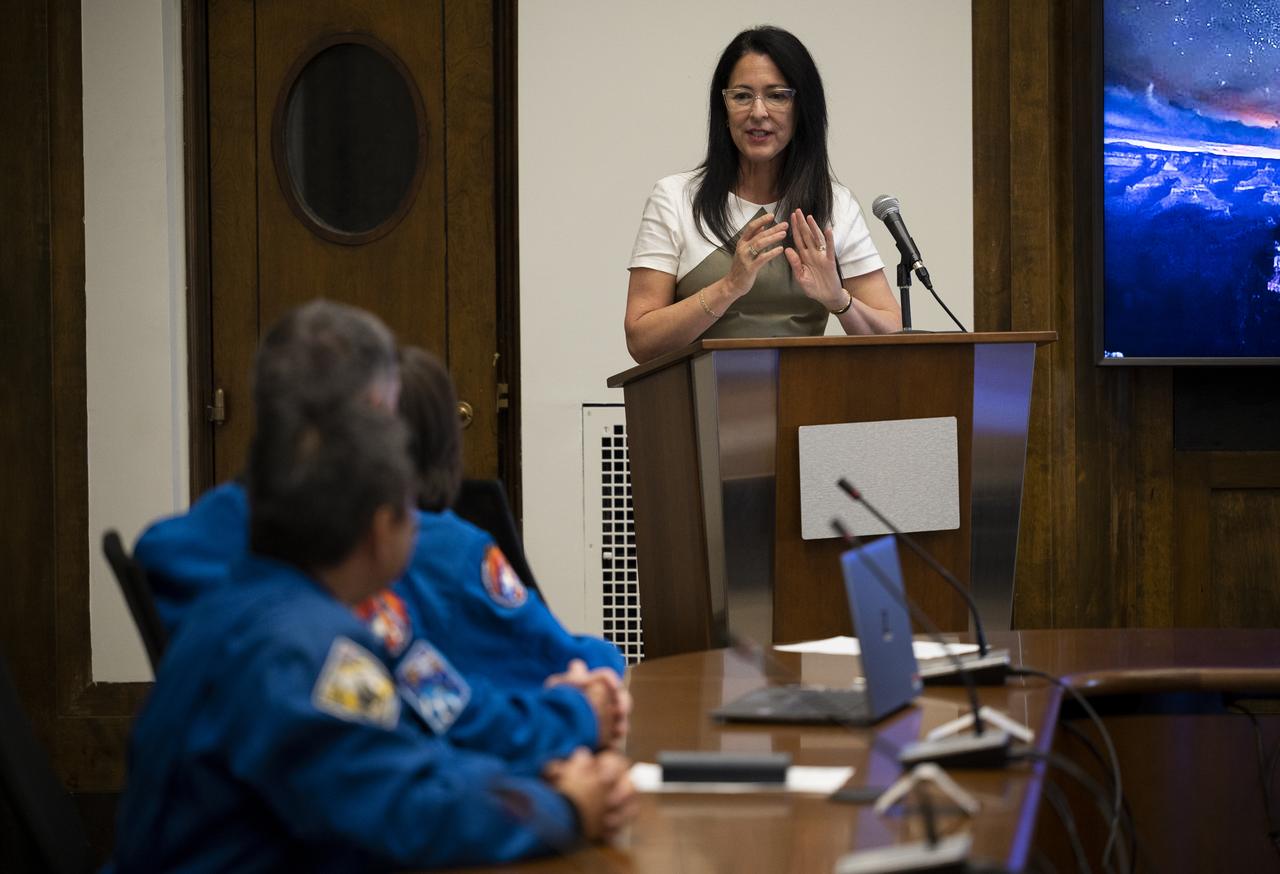
Shannon Estenoz, Assistant Secretary for Fish and Wildlife and Parks at the Department of the Interior, delivers remarks during a visit by NASA’s SpaceX Crew-2 astronauts with leadership and rangers who participate in the National Park Service’s astronomy and dark sky programs, Thursday, June 9, 2022 at the U.S. Department of the Interior in Washington, DC. NASA astronauts Shane Kimbrough and Megan McArthur, Japan Aerospace Exploration Agency (JAXA) astronaut Akihiko Hoshide, and ESA (European Space Agency) astronaut Thomas Pesquet completed the second crew rotation mission to the International Space Station as part of the agency’s Commercial Crew Program and spent 198 days aboard the orbiting laboratory as part of Expeditions 65 and 66. Photo Credit: (NASA/Joel Kowsky)
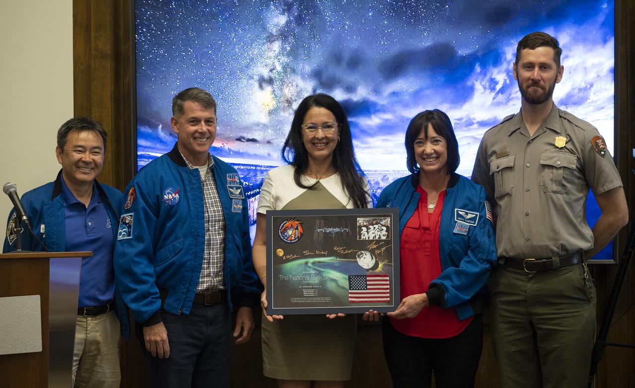
NASA’s SpaceX Crew-2 astronauts Akihiko Hoshide of the Japan Aerospace Exploration Agency (JAXA), left, Shane Kimbrough, second from left, and Megan McArthur, second from right, of NASA, pose for a picture with Shannon Estenoz, Assistant Secretary for Fish and Wildlife and Parks at the Department of the Interior, center, and park ranger Rader Lane, right, after presenting a montage to the National Park Service during a visit to the U.S. Department of the Interior, Thursday, June 9, 2022, Washington, DC. Kimbrough, McArthur, Hoshide, and ESA (European Space Agency) astronaut Thomas Pesquet completed the second crew rotation mission to the International Space Station as part of the agency’s Commercial Crew Program and spent 198 days aboard the orbiting laboratory as part of Expeditions 65 and 66. Photo Credit: (NASA/Joel Kowsky)
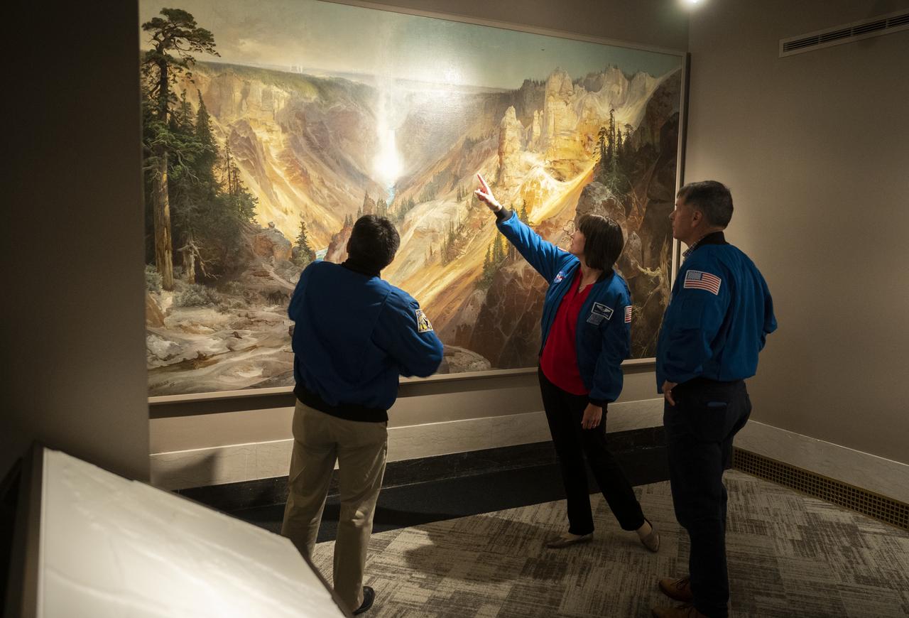
NASA’s SpaceX Crew-2 astronauts Akihiko Hoshide of the Japan Aerospace Exploration Agency (JAXA), left, and NASA astronauts Megan McArthur, center, and Shane Kimbrough, right, look at Thomas Moran’s 1872 painting “The Grand Canyon of Yellowstone,” Thursday, June 9, 2022, during a visit to the National Park Service at the U.S. Department of the Interior in Washington, DC. Kimbrough, McArthur, Hoshide, and ESA (European Space Agency) astronaut Thomas Pesquet completed the second crew rotation mission to the International Space Station as part of the agency’s Commercial Crew Program and spent 198 days aboard the orbiting laboratory as part of Expeditions 65 and 66. Photo Credit: (NASA/Joel Kowsky)

NASA astronaut Shane Kimbrough and Japan Aerospace Exploration Agency (JAXA) astronaut Akihiko Hoshide speak about NASA’s SpaceX Crew-2 mission during a presentation with leadership and rangers who participate in the National Park Service’s astronomy and dark sky programs, Thursday, June 9, 2022 at the U.S. Department of the Interior in Washington, DC. Kimbrough, Hoshide, NASA astronaut Megan McArthur, and ESA (European Space Agency) astronaut Thomas Pesquet completed the second crew rotation mission to the International Space Station as part of the agency’s Commercial Crew Program and spent 198 days aboard the orbiting laboratory as part of Expeditions 65 and 66. Photo Credit: (NASA/Joel Kowsky)

Park ranger Rader Lane speaks on the National Park Service’s astronomy and dark sky programs at Grand Canyon National Park during a visit by NASA’s SpaceX Crew-2 astronauts Megan McArthur and Shane Kimbrough of NASA, and Akihiko Hoshide of the Japan Aerospace Exploration Agency (JAXA), Thursday, June 9, 2022 at the U.S. Department of the Interior in Washington, DC. Kimbrough, McArthur, Hoshide, and ESA (European Space Agency) astronaut Thomas Pesquet completed the second crew rotation mission to the International Space Station as part of the agency’s Commercial Crew Program and spent 198 days aboard the orbiting laboratory as part of Expeditions 65 and 66. Photo Credit: (NASA/Joel Kowsky)

Park ranger Rader Lane speaks on the National Park Service’s astronomy and dark sky programs at Grand Canyon National Park during a visit by NASA’s SpaceX Crew-2 astronauts Megan McArthur and Shane Kimbrough of NASA, and Akihiko Hoshide of the Japan Aerospace Exploration Agency (JAXA), Thursday, June 9, 2022 at the U.S. Department of the Interior in Washington, DC. Kimbrough, McArthur, Hoshide, and ESA (European Space Agency) astronaut Thomas Pesquet completed the second crew rotation mission to the International Space Station as part of the agency’s Commercial Crew Program and spent 198 days aboard the orbiting laboratory as part of Expeditions 65 and 66. Photo Credit: (NASA/Joel Kowsky)

NASA’s SpaceX Crew-2 astronauts Megan McArthur and Shane Kimbrough of NASA, and Japan Aerospace Exploration Agency (JAXA) astronaut Akihiko Hoshide speak with Shannon Estenoz, Assistant Secretary for Fish and Wildlife and Parks, Thursday, June 9, 2022, during a visit to the U.S. Department of the Interior in Washington, DC. Kimbrough, McArthur, Hoshide, and ESA (European Space Agency) astronaut Thomas Pesquet completed the second crew rotation mission to the International Space Station as part of the agency’s Commercial Crew Program and spent 198 days aboard the orbiting laboratory as part of Expeditions 65 and 66. Photo Credit: (NASA/Joel Kowsky)

NASA astronaut Megan McArthur points to the shadow of the Gateway Arch on the Mississippi River in St. Louis while showing images of National Parks taken from the International Space Station during Expeditions 65 and 66 during a presentation to leadership and rangers who participate in the National Park Service’s astronomy and dark sky programs, Thursday, June 9, 2022 at the U.S. Department of the Interior in Washington, DC. McArthur, NASA astronaut Shane Kimbrough, Japan Aerospace Exploration Agency (JAXA) astronaut Akihiko Hoshide, and ESA (European Space Agency) astronaut Thomas Pesquet, flew on NASA’s SpaceX Crew-2 mission, the second crew rotation mission to the International Space Station as part of the agency’s Commercial Crew Program, and spent 198 days aboard the orbiting laboratory as part of Expeditions 65 and 66. Photo Credit: (NASA/Joel Kowsky)
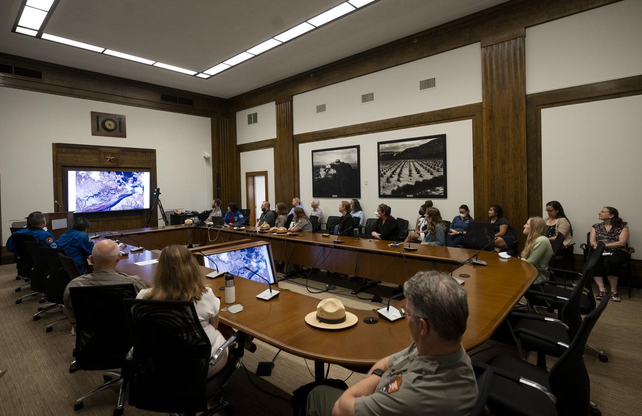
NASA astronaut Megan McArthur shows pictures of National Parks taken from the International Space Station during Expeditions 65 and 66 during a presentation to leadership and rangers who participate in the National Park Service’s astronomy and dark sky programs, Thursday, June 9, 2022 at the U.S. Department of the Interior in Washington, DC. McArthur, NASA astronaut Shane Kimbrough, Japan Aerospace Exploration Agency (JAXA) astronaut Akihiko Hoshide, and ESA (European Space Agency) astronaut Thomas Pesquet, flew on NASA’s SpaceX Crew-2 mission, the second crew rotation mission to the International Space Station as part of the agency’s Commercial Crew Program, and spent 198 days aboard the orbiting laboratory as part of Expeditions 65 and 66. Photo Credit: (NASA/Joel Kowsky)

NASA Administrator Charles Bolden, left, welcomes Secretary of the Interior Sally Jewell to NASA Headquarters to discuss continued partnerships between NASA and the Department of the Interior, Wednesday, Jan. 15, 2014 in Washington. Photo Credit: (NASA/Bill Ingalls)
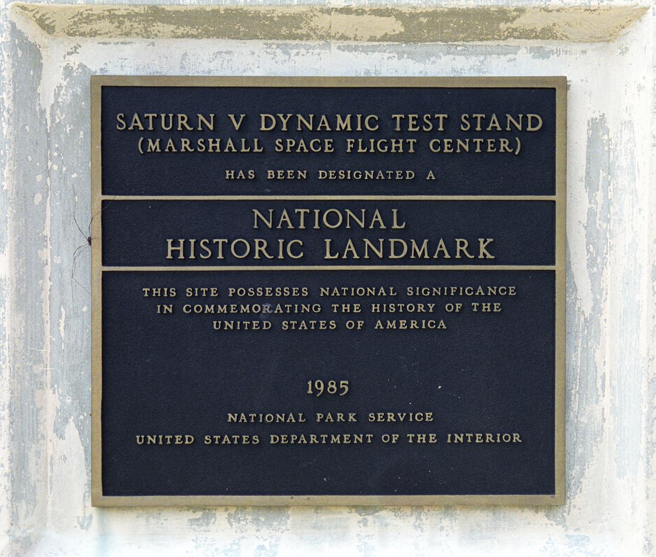
This plaque, displayed on the grounds of Marshall Space Flight Center in Huntsville, Alabama, commemorates the Saturn V Dynamic Test Stand as a National Historic Landmark. The site was designated as such in 1985 by the National Park Service of the United States Department of the Interior.
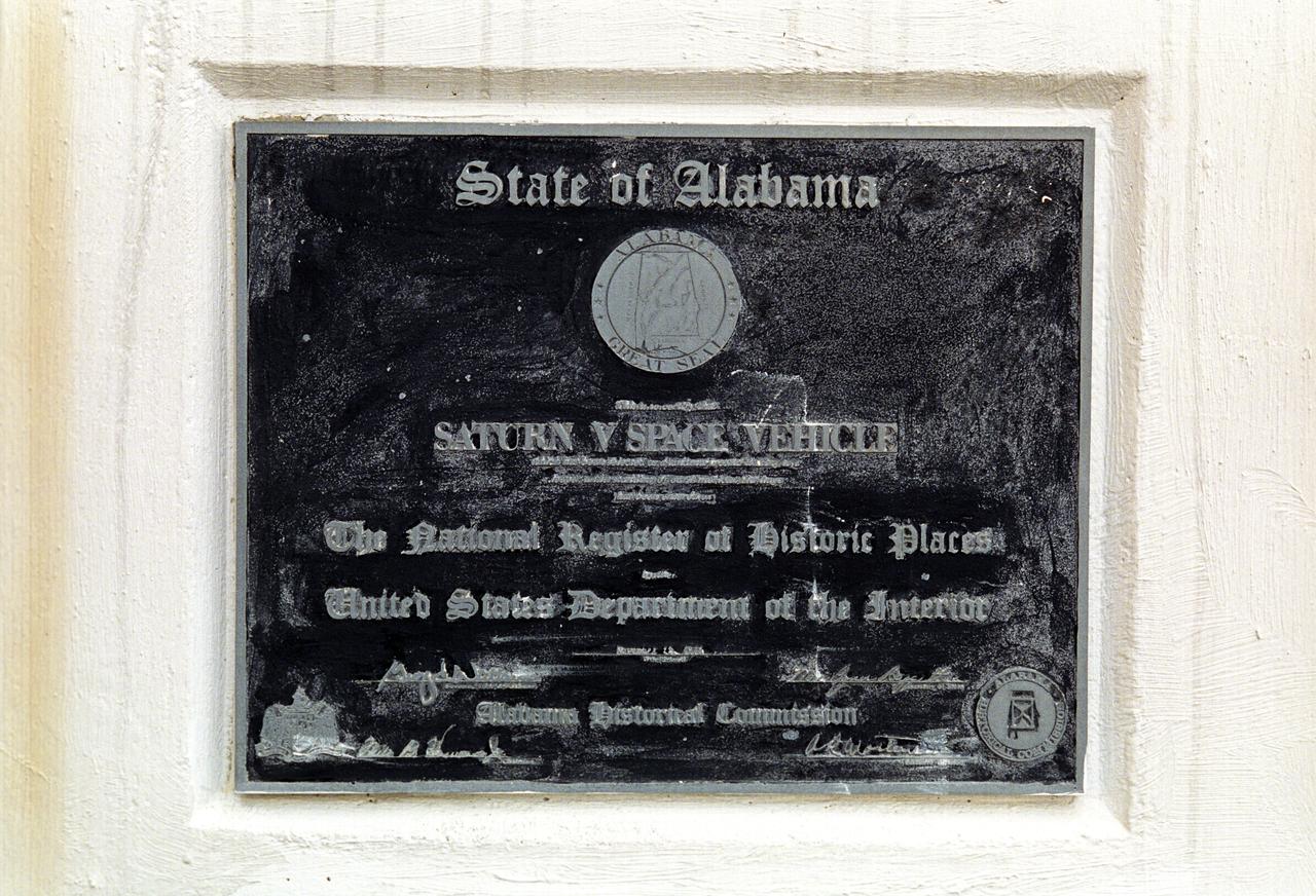
This plaque, displayed on the grounds of Marshall Space Flight Center in Huntsville, Alabama, commemorates the Saturn V Space Vehicle’s induction into the National Register of Historic Places by the United States Department of the Interior.
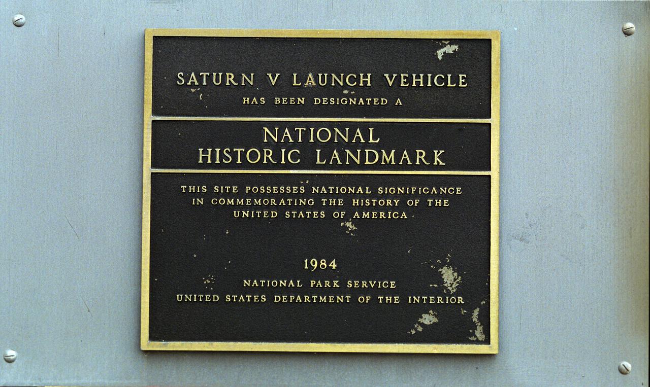
This plaque, displayed on the grounds of Marshall Space Flight Center in Huntsville, Alabama, commemorates the Saturn V Launch Vehicle as a National Historic Landmark. The site was designated as such in 1984 by the National Park Service of the United States Department of the Interior.
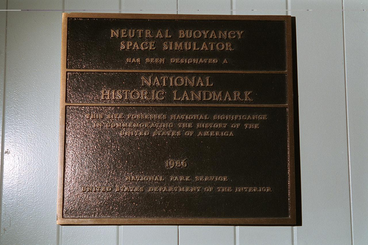
This plaque, displayed on the grounds of Marshall Space Flight Center in Huntsville, Alabama commemorates the Neutral Buoyancy Space Simulator as a National Historic Landmark. The site was designated as such in 1986 by the National Park Service of the United States Department of the Interior.
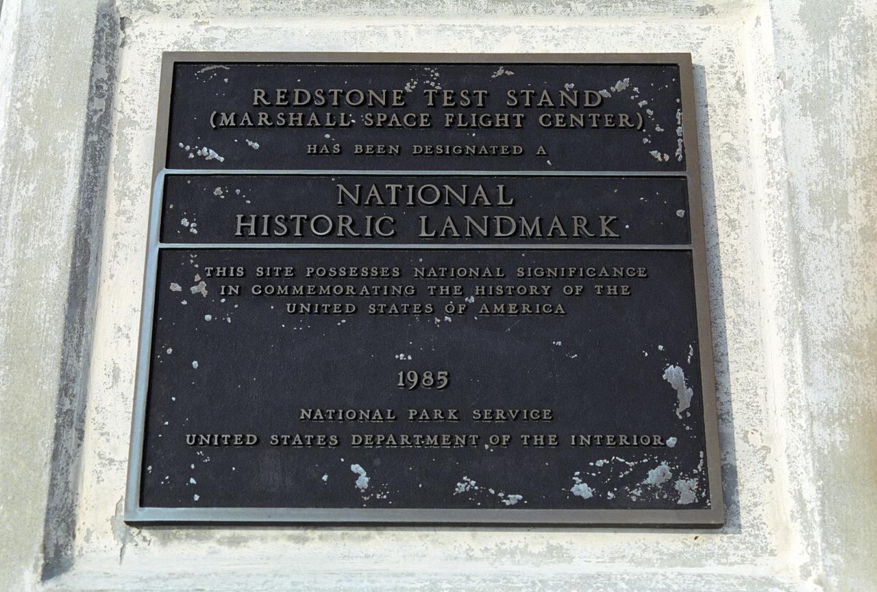
This plaque, displayed on the grounds of Marshall Space Flight Center in Huntsville, Alabama, commemorates the Redstone Test Stand as a National Historic Landmark. The site was designated as such in 1985 by the National Park Service of the United States Department of the Interior.
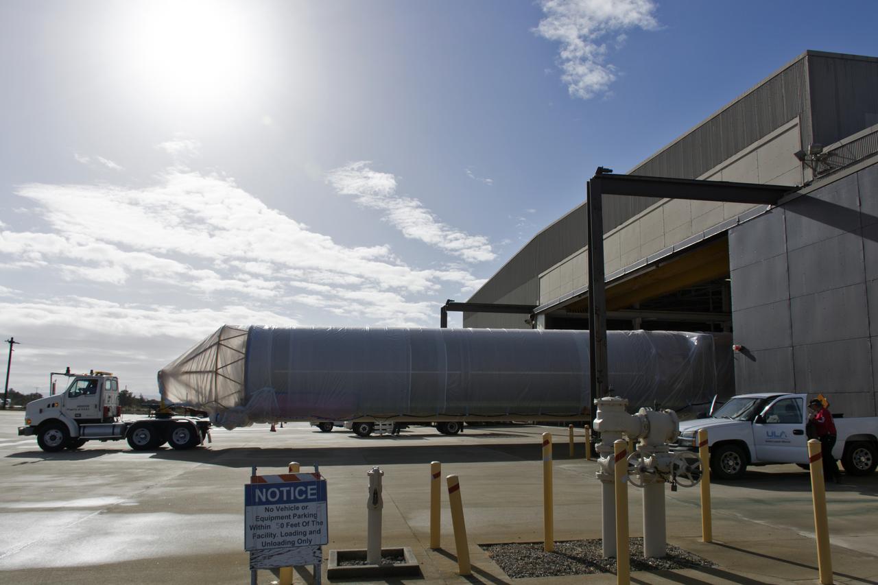
A United Launch Alliance Atlas V booster departs building 7525 at Vandenberg Air Force Base in California on its way to Space Launch Complex 3. The rocket will launch NASA's Interior Exploration using Seismic Investigations, Geodesy and Heat Transport, or InSight, mission to land on Mars. InSight is the first mission to explore the Red Planet's deep interior. It will investigate processes that shaped the rocky planets of the inner solar system including Earth. Liftoff is scheduled for May 5, 2018.

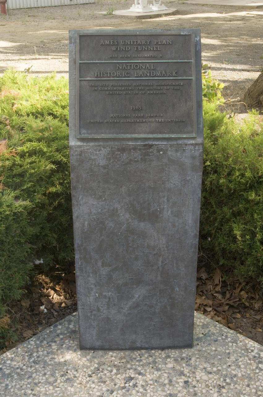
The Redstone Test Stand, shown here, was used throughout the 1950s to test the Redstone missionile, including the modified Redstone that launched America's first astronaut, Alan Shepard. The U. S. Department of the Interior's Park Services designated the Test Stand as a National Historic Landmark January 22, 1986.

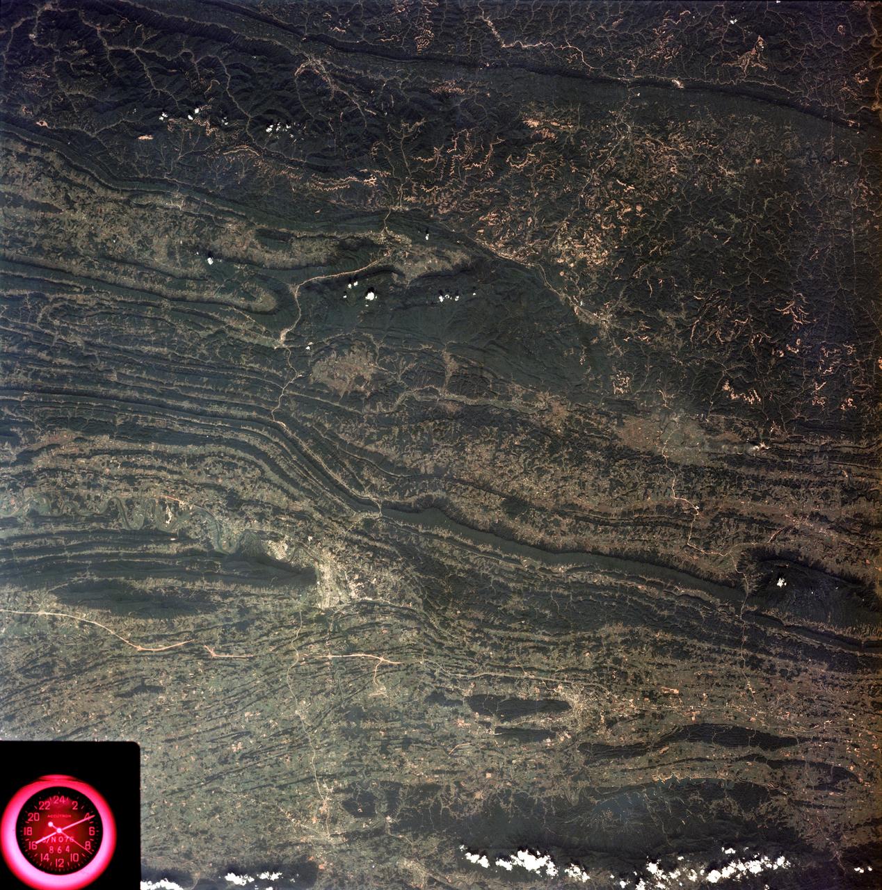
SL3-22-0214 (July-September 1973) --- A vertical view of southeastern Washington State as photographed from Earth orbit by one of the six lenses of the Itek-furnished S190-A Multispectral Photographic Facility Experiment aboard the Skylab space station. The Snake River flows into the Columbia River in the most southerly corner of the picture. The Wallula Lake is below the junction of the two rivers. The Yakima Valley is at the southwestern edge of the photograph. The Columbia Basin is in the center of the picture. The Cascade Range extends across the northwest corner of the photograph. This picture was taken with type SO-356 regular color film. The S190-A experiment is part of the Earth Resources Experiments Package. Federal agencies participating with NASA on the EREP project are the Departments of Agriculture, Commerce, Interior, the Environmental Protection Agency and the Corps of Engineers. All EREP photography is available to the public through the Department of Interior?s Earth Resources Observations Systems Data Center, Sioux Falls, South Dakota, 57198. Photo credit: NASA

SL3-40-077 (July-September 1973) --- A vertical view of the Mediterranean coastal area of southeastern France as photographed from Earth orbit by one of the six lenses of the Itek-furnished S190-A Multispectral Photographic Facility Experiment aboard the Skylab space station. This view of the coast extends from the eastern outskirts of Marseilles easterly to Cannes, and includes the city of Toulon. The S190-A experiment is part of the Skylab Earth Resources Experiments Package. Federal agencies participating with NASA on the EREP project are the Departments of Agriculture, Commerce, Interior, the Environmental Protection Agency and the Corps of Engineers. All EREP photography is available to the public through the Department of Interior?s Earth Resources Observations Systems Data Center, Sioux Falls, South Dakota, 57198. Photo credit: NASA
SL3-27-224 (July-September 1973) --- A vertical view of the western portion of the Republic of Panama on the Isthmus of Panama as photographed from Earth orbit by one of the six lenses of the Itek-furnished S190-A Multispectral Photographic Facility Experiment aboard the Skylab space station. This picture was taken with 2443 infrared color film. The large, clear body of water on the north side of the isthmus is Golfo de los Mosquitos, an extension of the Caribbean Sea. The large, partly cloud-covered body of water on the south side of the isthmus is Golfo de Chiriqui, an extension of the Pacific Ocean. Federal agencies participating with NASA on the EREP project are the Department of Agriculture, Commerce, Interior, the Environmental Protection Agency and the Corps of Engineers. All EREP photography is available to the public through the Department of Interior?s Earth Resources Observation Systems Data Center, Sioux Falls, South Dakota, 57198. Photo credit: NASA
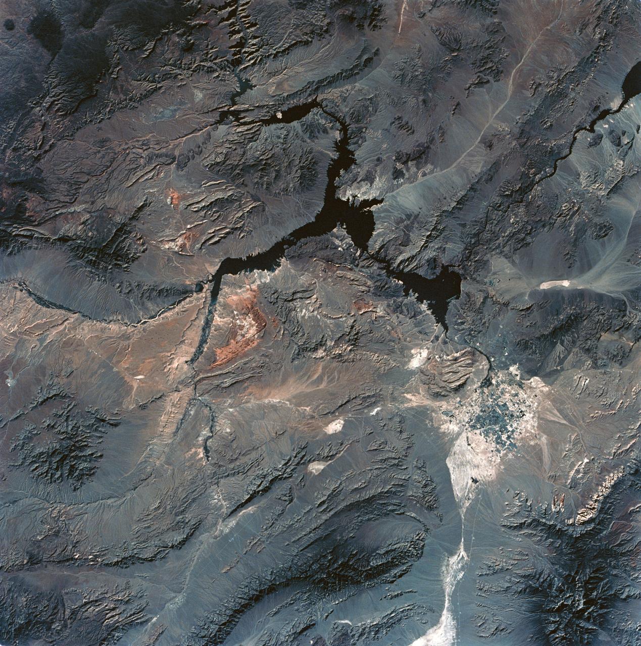
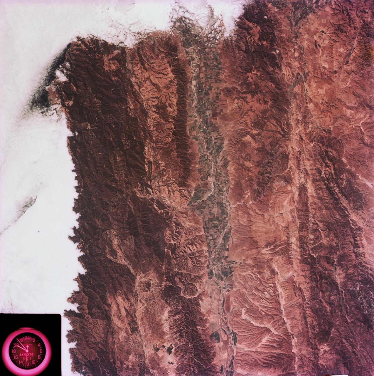
SL3-28-059 (July-September 1973) --- A vertical view of the Lake Mead and Las Vegas, Nevada area as photographed from Earth orbit by one of the six lenses of the Itek-furnished S190-A Multispectral Photographic Facility Experiment aboard the Skylab space station. Lake Mead is water of the Colorado River impounded by Hoover Dam. Most of the land in the picture is Nevada. However, a part of the northwest corner of Arizona can be seen. Federal agencies participating with NASA on the EREP project are the Departments of Agriculture, Commerce, Interior, the Environmental Protection Agency and the Corps of Engineers. All EREP photography is available to the public through the Department of Interior?s Earth Resources Observations Systems Data Center, Sioux Falls, South Dakota, 57198. Photo credit: NASA
SL2-10-250 (May-June 1973) --- A vertical view of eastern Iowa and northwestern Illinois, as photographed from Skylab space station in Earth orbit. Davenport, Burlington and Muscatine, Iowa; and Rock Island and Moline, Illinois can be delineated on opposite sides of the Mississippi River. The Iowa River and tributaries of it can also be delineated. This photograph was taken with one of six lenses of the Itek-furnished Multispectral Photographic Facility Experiment S190-A mounted in the Multiple Docking Adapter (MDA) of the space station. A six-inch lens, using 70mm medium speed Ektachrome (SO-356) film, was used. Agencies participating with NASA on the EREP project are the Departments of Agriculture, Commerce and Interior; the Environmental Protection Agency and the Corps of Engineers. All EREP photography is available to the public through the Department of Interior's Earth Resources Observations Systems Data Center, Sioux Falls, South Dakota, 57198. Photo credit: NASA
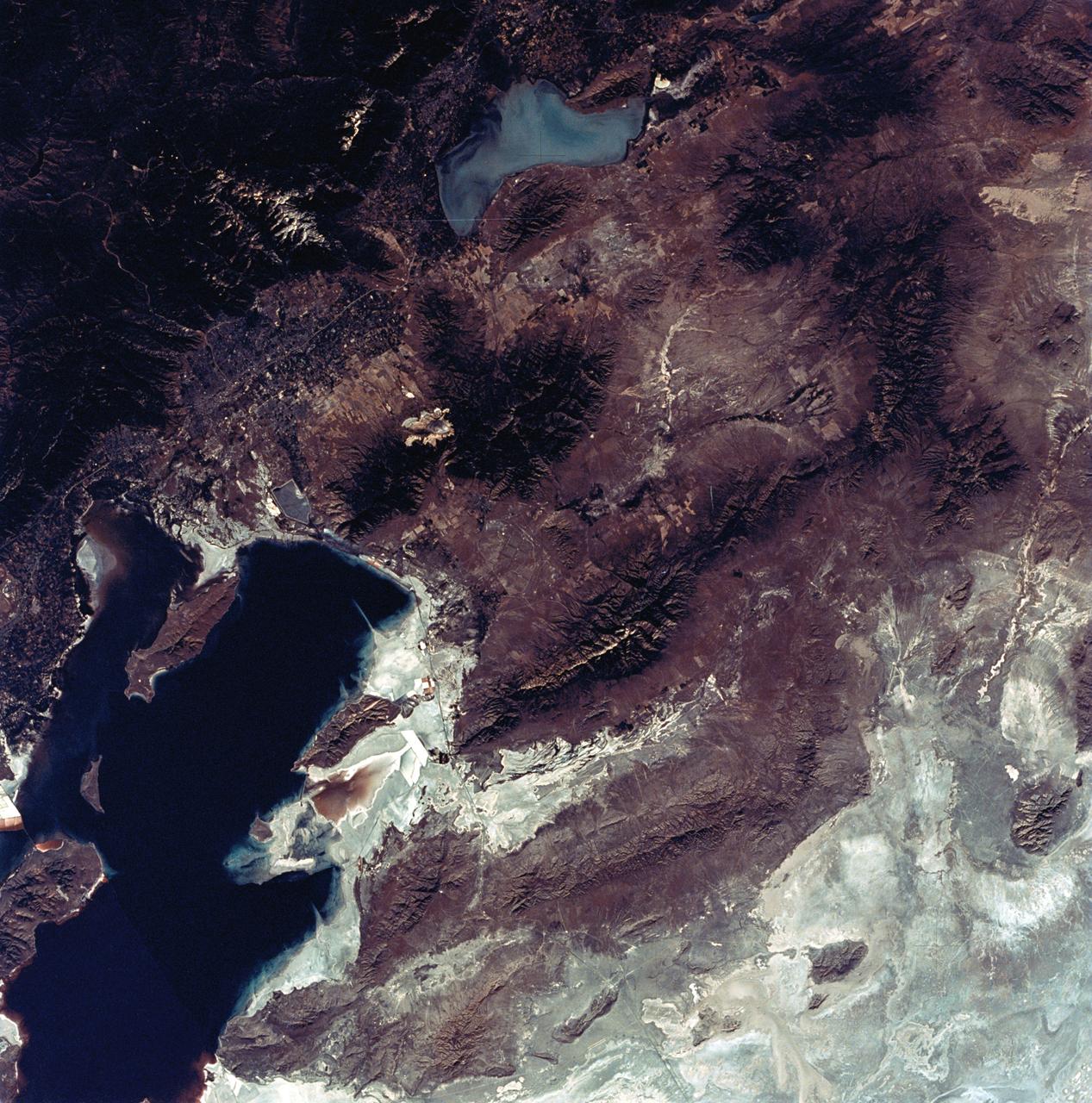
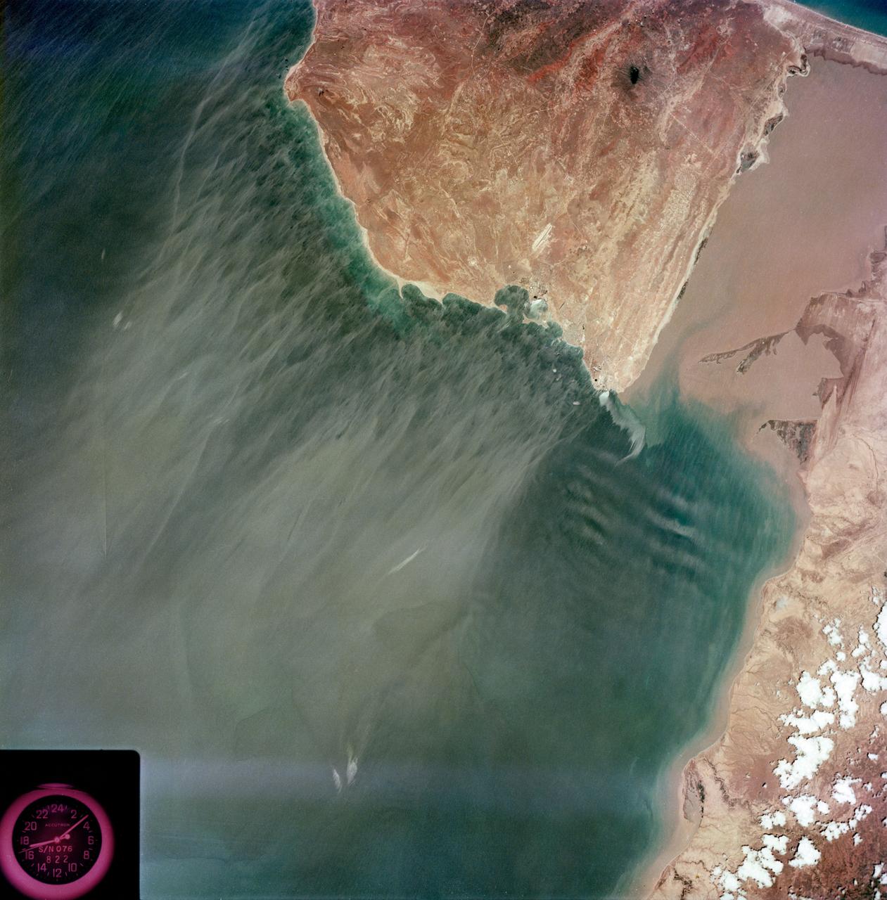
SL3-22-0322 (July-September 1973) --- An oblique view of the Salt Lake City, Utah area as photographed from Earth orbit by one of the six lenses of the Itek-furnished S190-A Multispectral Photographic Facility Experiment aboard the Skylab space station. Approximately two-thirds of the Great Salt Lake is in view. The smaller body of water south of Salt Lake City is Utah Lake. The Wasatch Range is on the east side of the Great Salt Lake. Federal agencies participating with NASA on the EREP project are the Departments of Agriculture, Commerce, Interior, the Environmental Protection Agency and the Corps of Engineers. All EREP photography is available to the public through the Department of Interior?s Earth Resources Observations Systems Data Center, Sioux Falls, South Dakota, 57198. Photo credit: NASA
SL3-27-180 (July-September 1973) --- A vertical view of the Snowy Mountains area of Australian Alps in the States of Victoria and New South Wales, Australia, as photographed from Earth orbit by one of the six lenses of the Itek-furnished S190-A Multispectral Photographic Facility Experiment aboard the Skylab space station. This picture was taken with type 2443 infrared color film. The lake near the center of the picture is the Eucumbene Reservoir. This area is located immediately south-southwest of the capital city of Canberra. Federal agencies participating with NASA on the EREP project are the Departments of Agriculture, Commerce, Interior, the Environmental Protection Agency and the Corps of Engineers. All EREP photography is available to the public through the Department of Interior?s Earth Resources Observations Systems Data Center, Sioux Falls, South Dakota, 57198. Photo credit: NASA
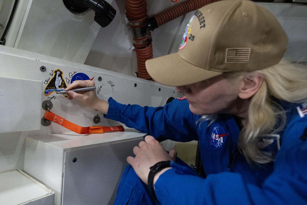
NASA astronaut Deniz Burnham signs an interior panel of the Crew Module Test Article (CMTA) during Underway Recovery Test-12 onboard USS Somerset off the coast of California, Saturday, March 29, 2025. During the test, NASA and Department of Defense teams are practicing to ensure recovery procedures are validated as NASA plans to send the Artemis II astronauts around the Moon and splashdown in the Pacific Ocean. Photo Credit: (NASA/Joel Kowsky)

NASA astronaut Stan Love signs an interior panel of the Crew Module Test Article (CMTA) during Underway Recovery Test-12 onboard USS Somerset off the coast of California, Saturday, March 29, 2025. During the test, NASA and Department of Defense teams are practicing to ensure recovery procedures are validated as NASA plans to send the Artemis II astronauts around the Moon and splashdown in the Pacific Ocean. Photo Credit: (NASA/Joel Kowsky)
Ames and Moffett Field (MFA) historical sites and memorials Unitary Plan Wind Tunned plaza; display and historical site plaques with the NASA logo on the Wind Tunnel valve as a backdrop. Plaque depicts that Ames Unitary Plan Wind Tunnel has been designated a National Historic Landmark by the National Park Service, United States Department of the Interior 1985 The plaque reads; This site possesses national significance in commemorating the history of the United States of America. That ceremony took place on September 12, 1990

ESA (European Space Agency) astronaut Luca Parmitano signs an interior panel of the Crew Module Test Article (CMTA) during Underway Recovery Test-12 onboard USS Somerset off the coast of California, Saturday, March 29, 2025. During the test, NASA and Department of Defense teams are practicing to ensure recovery procedures are validated as NASA plans to send the Artemis II astronauts around the Moon and splashdown in the Pacific Ocean. Photo Credit: (NASA/Joel Kowsky)
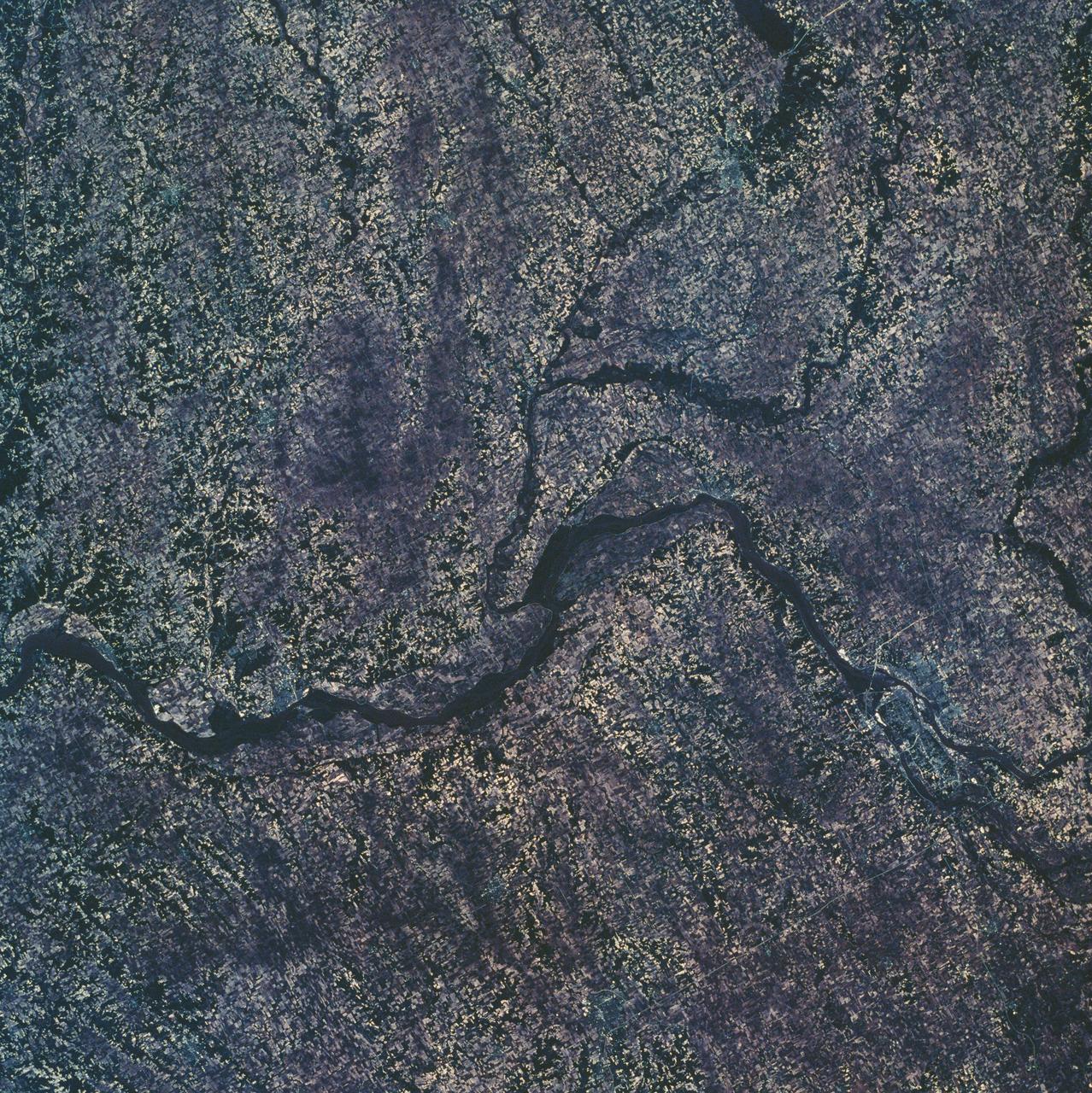
SL3-45-020 (July-September 1973) --- A vertical view of the Virginia-Tennessee-Kentucky border area as photographed from Earth orbit by one of the six lenses of the Itek-furnished S190-A Multispectral Photographic Facility Experiment aboard the Skylab space station. This picture was taken with type 2443 infrared color film. The S190-A experiment is part of the Skylab Earth Resources Experiments Package. The long, narrow ridge is Pine Mountain; and it is crossed by U.S. 25E at Pineville near its southernmost end. Some 25 miles south of Pineville U.S. 25E passes through the famed Cumberland Gap which at 1,600 feet elevation crosses Cumberland Mountain. Kingsport, Tennessee is located east of Cumberland Gap near the center of the picture. Bristol, Tennessee-Virginia is further east. Greenville and Elizabethton, Tennessee can also be seen in this photograph. The clouds across the southeast edge of the picture are over the Blue Ridge Mountains. Federal agencies participating with NASA on the EREP project are the Departments of Agriculture, Commerce, Interior, the Environmental Protection Agency and the Corps of Engineers. All EREP photography is available to the public through the Department of Interior?s Earth Resources Observations Systems Data Center, Sioux Falls, 57198. Photo credit: NASA
SL3-33-167 (July-September 1973) --- A vertical view of the Argentina-Paraguay border area of South America as photographed from Earth orbit by one of the six lenses of the Itek-furnished S190-A Multispectral Photographic Facility Experiment aboard the Skylab space station. This picture was taken with type 2443 infrared color film. The Parana River flows from east to west across the picture. This part of the Rio Parana is located between the towns of Posadas, Argentina, and Resistencia, Argentina. The major body of water in the large swamp area is Laguna Ibera. Note the several fires burning in this area. The largest land mass (Argentina) is south of the river. Paraguay is north of the river. Isla Apipe Grande is near the center of the photograph. The S190-A experiment is part of the Skylab Earth Resources Experiments Package. Federal agencies participating with NASA on the EREP project are the Departments of Agriculture, Commerce, Interior, the Environmental Protection Agency and the Corps of Engineers. All EREP photography is available to the public through the Department of Interior?s Earth Resources Observations Systems Data Center, Sioux Falls, South Dakota, 57198. Photo credit: NASA
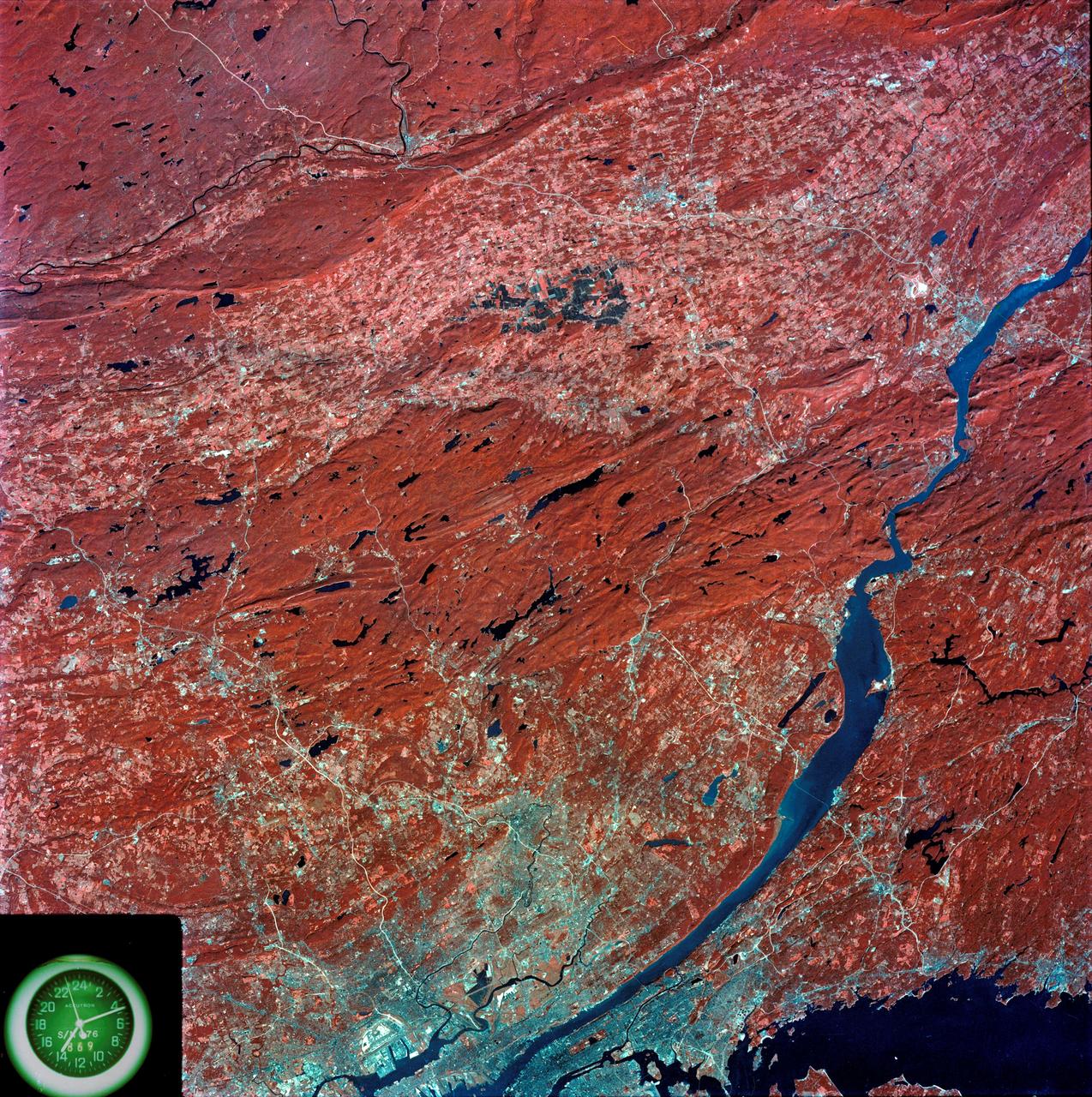
SL3-87-299 (July-September 1973) --- A vertical view of southeastern New York State is seen in this Skylab 3 Earth Resources Experiments Package S190-B (five-inch Earth terrain camera) infrared photograph taken from the Skylab space station in Earth orbit. An 18-inch, 450mm lens and type 2443 infrared Ektachrome film was used. This picture covers the northern part of New Jersey, a part of northwestern Pennsylvania, and the western tip of Connecticut. The body of water is Long Island Sound. The wide Hudson River flows southward across a corner of the photograph. The New York City metropolitan area occupies part of the picture. Federal agencies participating with NASA on the EREP project are the Departments of Agriculture, Commerce, Interior, the Environmental Protection Agency and the Corps of Engineers. All EREP photography is available to the public through the Department of Interior?s Earth Resources Observations Systems Data Center, Sioux Falls, South Dakota, 57198. Photo credit: NASA
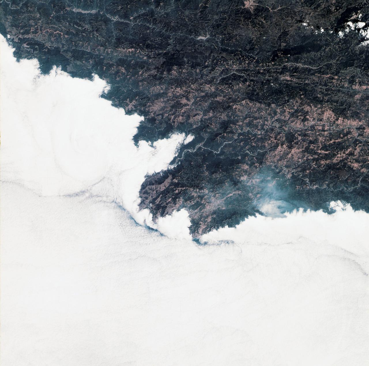
SL3-34-336 (July-September 1973) --- A vertical view of a portion of northern California near the Pacific coast as photographed from Earth orbit by one of the six lenses of the Itek-furnished S190-A Multispectral Photographic Facility Experiment in the Multiple Docking Adapter of the Skylab space station. A cloud deck covers the Pacific Ocean. Most of Cape Mendocino is clear of clouds and extends into the Pacific as the westernmost part of California. The sinuous pattern of the Bel River (in center) flows northward into the ocean and is characteristic of the rivers that drain the coastal ranges. This area is immediately southeast of Eureka. During Skylab 3 extensive forest fires occurred near Briceland and the smoke rising from the fires is clearly visible next to the cloud bank. Redwood and fir forests are sources of lumber in this region; and a variety of clear cut (timbering) patterns appear as light against the dark forest. The patterns appear to be related to the topography. Analysis of this photograph will aid Dr. P.G. Langley, Earth Satellite Corporation, in developing methods for forest inventory using space photography. Federal agencies participating with NASA on the EREP project are the Departments of Agriculture, Commerce, Interior, the Environmental Protection Agency and the Corps of Engineers. All EREP photography is available to the public through the Department of Interior?s Earth Resources Observations Systems Data Center, Sioux Falls, South Dakota, 57198. Photo credit: NASA

SL3-33-156 (July-September 1973) --- A near vertical view of the Florence, Italy area as photographed from Earth orbit by one of the Itek-furnished S190-A Multispectral Photographic Facility Experiment aboard the Skylab space station. The view extends from the Ligurian Sea, an extension of the Mediterranean Sea, across the Apennine Mountains to the Po River Valley. Florence (Firenze) is near the center of the land mass. The mouth of the Arno River is at the center of the coastline. The city of Leghorn (Livorno) is on the coast just south of the Arno River. This picture was taken with type 2443 infrared color film. The S190-A experiment is part of the Skylab Earth Resources Experiments Package. Federal agencies participating with NASA on the EREP project are the Department of Agriculture, Commerce, Interior, the Environmental Protection Agency and the Corps of Engineers. All EREP photography is available to the public through the Department of Interior?s Earth Resources Observations Systems Data Center, Sioux Falls, South Dakota, 57198. Photo credit: NASA
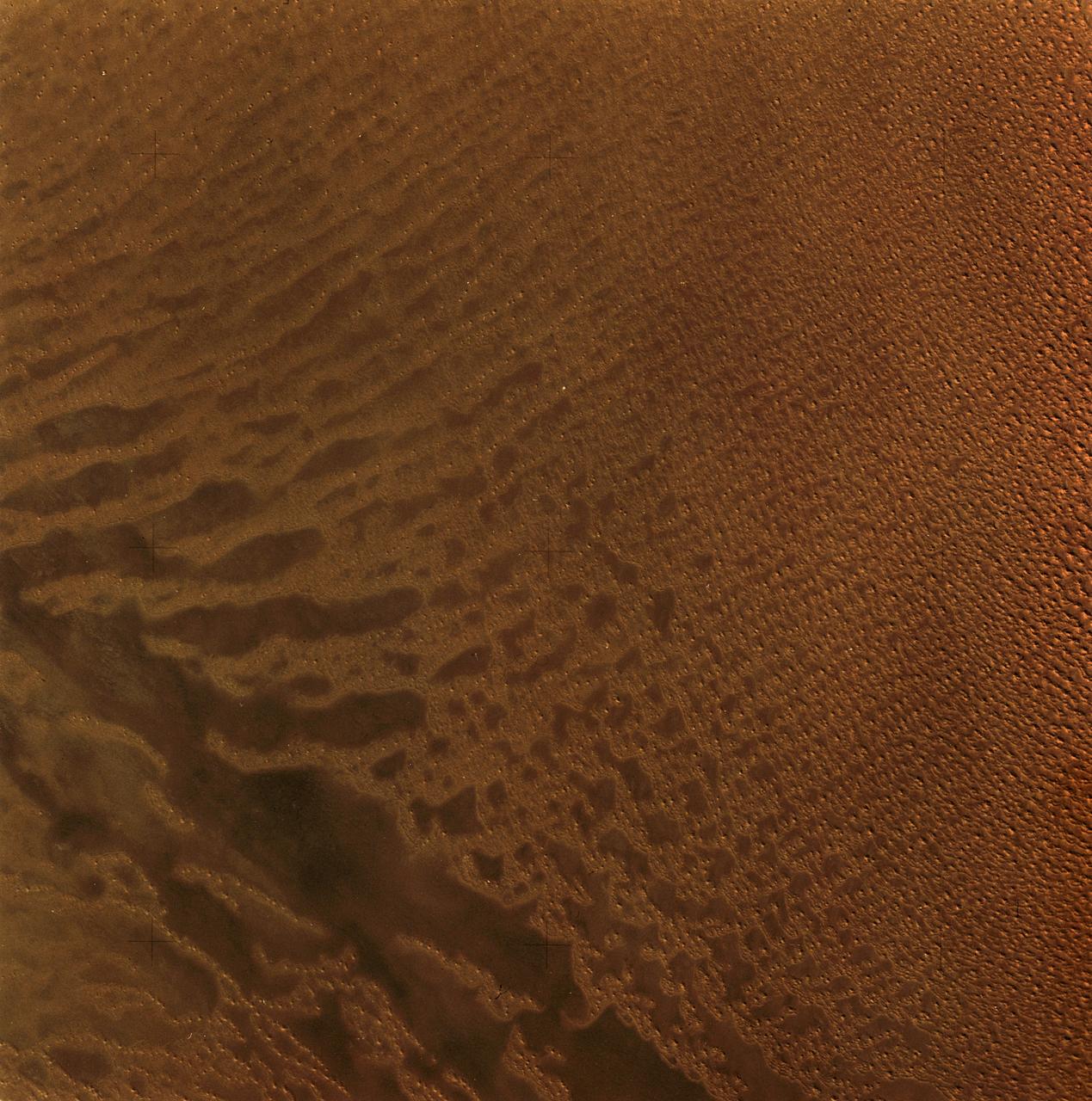
SL3-34-056 (July-September 1973) --- A near vertical view of an 8,000 square-mile area of the Grand Erg Oriental in east central Algeria as photographed from Earth orbit by one of the six lenses of the Itek-furnished S190-A Multispectral Photographic Facility Experiment in the Multiple Docking Adapter of the Skylab space station. The Grand Erg contains vast areas of sand dunes and sand plains. This photograph illustrates the variety of surface features that are characteristic of the Sahara Desert. The dark areas are relatively sand free, and may contain rock outcrops along which travel is considerably easier. Sand dunes are abundant in this picture, and their size, shape, location and pattern are due to the underlying topography and direction of the prevailing winds. Scientists interested in study of dune fields will be able to use this photograph for detailed analysis of the dune features, especially their characteristics adjacent to the sand-free areas. Federal agencies participating with NASA on the EREP project are the Departments of Agriculture, Commerce, Interior, the Environmental Protection Agency and the Corps of Engineers. All EREP photography is available to the public through the Department of Interior?s Earth Resources Observations Systems Data Center, Sioux Falls, South Dakota, 57198. Photo credit: NASA
A white pelican named "Fisheater" by its rescuers, beats its wings as it flies to freedom at the Merritt Island National Wildlife Refuge. The pelican was found covered in crude oil from a contaminated ditch in northern Indiana in November, and was rescued by a local Police Department, treated, and flown to the Back to Nature Wildlife Refuge in Orlando, Fla. for care and rest. It is being released today to join a flock of about 30 other white pelicans that are wintering on the refuge. Before its release, however, Kat Royer, with the U.S. Fish and Wildlife Service, placed on it a leg band issued by the U.S. Department of the Interior's Bird Banding Laboratory. White pelicans inhabit marshy lakes and along the Pacific and Texas coasts. They winter from Florida and southern California south to Panama, chiefly in coastal lagoons. They are frequently seen flying in long lines, flapping and sailing in unison, but also ride rising air currents to soar gracefully in circles. The Merritt Island National Wildlife Refuge, which encompasses 92,000 acres that are a habitat for more than 331 species of birds, 31 mammals, 117 fishes, and 65 amphibians and reptiles. The marshes and open water of the refuge provide wintering areas for 23 species of migratory waterfowl, as well as a year-round home for great blue herons, great egrets, wood storks, cormorants, brown pelicans and other species of marsh and shore birds, as well as a variety of insects
VANDENBERG AFB, Calif. -- At Space Launch Complex 3E at Vandenberg Air Force Base, Anne Castle, assistant secretary for Water and Science, U.S. Department of the Interior, discuss the Landsat Data Continuity Mission, or LDCM, satellite mission with NASA social media followers. The Landsat Data Continuity Mission LDCM is the future of Landsat satellites. It will continue to obtain valuable data and imagery to be used in agriculture, education, business, science, and government. The Landsat Program provides repetitive acquisition of high resolution multispectral data of the Earth's surface on a global basis. The data from the Landsat spacecraft constitute the longest record of the Earth's continental surfaces as seen from space. It is a record unmatched in quality, detail, coverage, and value. Liftoff is planned for Feb. 11, 2013 aboard a United Launch Alliance Atlas V rocket. For more information, visit: http:__www.nasa.gov_mission_pages_landsat_main_index.html Photo credit: NASA_Kim Shiflett

VANDENBERG AIR FORCE BASE, Calif. -- Media attending a post-launch news conference at Vandenberg Air Force Base, Calif. heard from Anne Castle, assistant secretary for Water and Science, U.S. Department of the Interior. The Landsat Data Continuity Mission LDCM is the future of Landsat satellites. It will continue to obtain valuable data and imagery to be used in agriculture, education, business, science, and government. The Landsat Program provides repetitive acquisition of high resolution multispectral data of the Earth's surface on a global basis. The data from the Landsat spacecraft constitute the longest record of the Earth's continental surfaces as seen from space. It is a record unmatched in quality, detail, coverage, and value. Liftoff took place at 10:02 a.m. PST 1:02 P.M. EST) on Feb. 11, 2013 aboard a United Launch Alliance Atlas V rocket. For more information, visit: http:__www.nasa.gov_mission_pages_landsat_main_index.html Photo credit: NASA_Kim Shiflett

STS090-774-028 (29 April 1998) --- This view features a 13,980-foot mountain peak in Colorado’s Sangre de Cristo Mountains in Saguache County, photographed by crewmembers of the STS-90 Space Shuttle Columbia mission in April 1998. EDITOR’S NOTE: In June 2003, the summit was named “Columbia Point” by the U.S. Department of Interior in memory of the STS-107 Space Shuttle Columbia crew, lost in an accident on February 1, 2003, and for the scientific exploration, technical excellence, and the dream of spaceflight for which the mission stood. Columbia Point is located on the east side of Kit Carson Mountain. On the northwest shoulder of the same mountain is Challenger Point, a peak previously named in memory of the Space Shuttle Challenger, which exploded soon after liftoff on January 28, 1986.

SL4-93-167 (February 1974) --- A vertical view of the Kennedy Space Center and the Florida Atlantic coast area is seen in this Skylab 4 Earth Resources Experiments Package S190-B (five-inch earth terrain camera) infrared photography taken from the Skylab space station in Earth orbit. This photograph shows the major land-ocean features of the Florida coast near Vero Beach northward to Cape Canaveral and the KSC complex. The launch pads for the Skylab missions are clearly visible. Identification of living vegetation is possible through the use of the color infrared film. Various shades of red portray differences in the vegetation such as shown in the patterns in the agricultural area near Vero Beach. In the Kennedy Space Center, the nearly continuous and uniform red color shows that most of the land areas are heavily vegetated. The white coastal beach areas are strongly contrasted to the red land and the blue Atlantic Ocean. Old dunal areas in KSC are visible on Merritt Island which is separated from the Launch areas by the Banana River and the mainland by the Indian River. Federal and state highways and numerous causeways over the rivers are easily identified. The Florida mainland is partly shadowed by small white clouds which cast a pronounced shadow to the east of each cloud indicated the Sun is west of solar noon. Federal agencies participating with NASA on the EREP project are the Departments of Agriculture, Commerce, Interior, the Environmental Protection Agency and the Core of Engineers. All EREP photography is available to the public through the Department of Interior's Earth Resources Observations Systems Data Center, Sioux Falls, South Dakota, 57198. Photo credit: NASA
S73-35079 (July-September 1973) --- A near vertical view of the Caribbean coast of Venezuela is seen in this Skylab 3 Earth Resources Experiment Package S190-B (five-inch Earth terrain camera) photograph taken from the Skylab space station in Earth orbit. The large body of water is the Golfo de Venezuela; and the major land mass is the Peninsula de Paraguana. The view is looking northward from the mouth of the Golfete de Coro and Punta Cardon to Punta Macolla. The peninsula is connected to the Venezuelan mainland by the narrow strip of land in the most easterly corner of the picture. The dry, arid climate on the peninsula is indicated by sparse vegetation and the abundance of sand dunes. The highest point is about 2,700 feet above the sea and is the conspicuous black spot. Old raised shoreline features appear as streaks parallel to the Golfete de Coro. Sand dunes and stream erosion have modified these features. Water of the Golfete de Coro is red from the high sediment content. The streaks in the water off the peninsula is apparently an effect of wind which is blowing sand and water offshore. The EREP investigator Dr. Jose Antonio Galavis, of the Ministerio de Mines e Hidrocarburos, will use this information to map geology and coastal sedimentation in the Peninsula de Paraguana. Federal agencies participating with NASA on the EREP projects are the Departments of Agriculture, Commerce, Interior, the Environmental Protection Agency and the Corps of Engineers. All EREP photography is available to the public through the Department of Interior?s Earth Resources Observations Systems Data Center, Sioux Falls, South Dakota, 57198. (Alternate number SL3-83-237) Photo credit: NASA
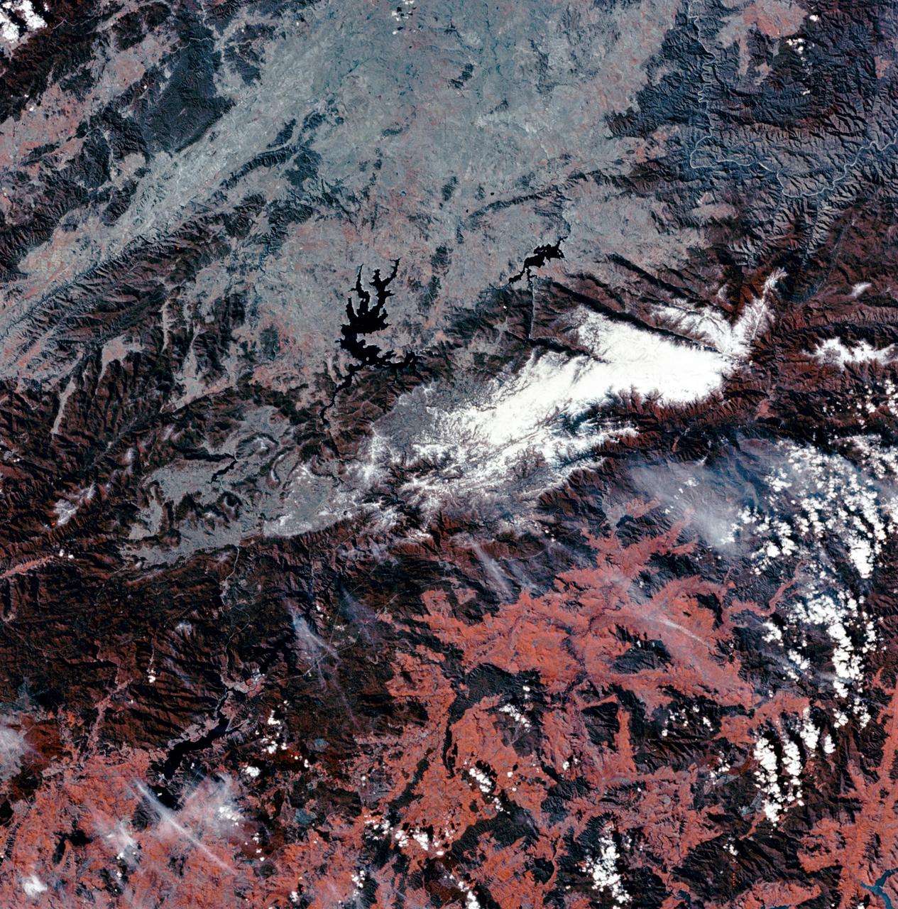
S73-35081 (July-September 1973) --- A view of approximately 3,600 square miles of north central Wyoming and southern Montana is seen in this Skylab 3 Earth Resources Experiments Package S190-B (five-inch Earth terrain camera) photograph taken from the Skylab space station in Earth orbit. The Big Horn River following northward crosses between the northwest trending Big Horn Mountains and the Pryor Mountains. Yellowtail Reservoir, named after a former chief of the Crow Indian tribe in the center of the picture is impounded by a dam across the small rectangular crop area along the Big Horn River (upper right) and the strip farming (yellow) practiced on the rolling hill along the Big Horn River and its tributaries (upper left corner and right edge). The low sun angle enhances the structural features of the mountains as well as the drainage patterns in the adjacent basins. Rock formation appears in this color photograph as they would to the eye from this altitude. The distinctive redbeds can be traced along the front of the Pryor Mountains and indicate the folding that occurred during mountain building. EREP investigators, Dr. Houston of the University of Wyoming and Dr. Hoppin of the University of Iowa, will analyze the photograph and use the results in geological mapping and mineral resource studies. Lowell, Wyoming (lower left corner) and Hardin, Montana (upper right corner) can be recognized. Federal agencies participating with NASA on the EREP project are the Departments of Agriculture, Commerce, Interior, the Environmental Protection Agency and the Corps of Engineers. All EREP photography is available to the public through the Department of Interior?s Earth Resources Observations Systems Data Center, Sioux Falls, South Dakota, 57198. (Alternate number SL3-86-337) Photo credit: NASA
SL4-92-300 (February 1974) --- A near vertical view of the Mobile Bay, Alabama area is seen in this Skylab 4 Earth Resources Experiments Package S190-B (five-inch earth terrain camera) photograph taken from the Skylab space station in Earth orbit. North of Mobile the Tombigbee and Alabama Rivers join to form the Mobile River. Detailed configuration of the individual stream channels and boundaries can be defined as the Mobile River flows into Mobile Bay, and thence into the Gulf of Mexico. The Mobile River Valley with its numerous stream channels is a distinct light shade in contrast to the dark green shade of the adjacent areas. The red coloration of Mobile Bay reflects the sediment load carried into the Bay by the rivers. Variations in red color indicate sediment load and the current paths within Mobile Bay. The waterly movement of the along shore currents at the mouth of Mobile Bay is shown by the contrasting light blue of the sediment-laden current and the blue of the Gulf predominately. Agricultural areas east and west of Mobile Bay are characterized by a rectangular pattern in green to white shades. Color variations may reflect the type and growth cycle of crops. Agricultural areas (light gray-greens) are also clearly visible in other parts of the photograph. Interstate 10 extends from near Pascagoula, Mississippi eastward through Mobile to the outskirts of Pensacola, Florida. Analysis of the EREP photographic data will be undertaken by the U.S. Corps of Engineers to determine bay dynamic processes. Federal agencies participating with NASA on the EREP project are the Departments of Agriculture, Commerce, Interior, the Environmental Protection Agency and the Corps of Engineers. All EREP photography is available to the public through the Department of Interior's Earth Resources Observations Systems Data Center, Sioux Falls, South Dakota. 57198 Photo credit: NASA
SL3-88-004 (July-September 1973) --- A vertical view of the Salinas River Valley area south of Monterey Bay, California area is seen in this Skylab 3 Earth Resources Experiments Package S190-B (five-inch Earth terrain camera) photograph taken from the Skylab space station in Earth orbit. The valley is an irrigated agricultural area, and is indicated by the dark-green and light-gray rectangular patterns in the centre of the picture. The city of Salinas is barely visible under the cloud cover at the top (north) end of the valley. The dark mass on the left (west) side of the valley is the Santa Lucia mountain range. The Big Sur area is on the left and partly covered by clouds. The Diablo Range forms the dark mass in the lower right (southeast) corner of the photograph. The town of Hollister is the gray area in the dark-green rectangular farm tracts which occupy the floor of the San Benito Valley in the upper right (northeast) corner of the photograph. The Salinas River flows northwestward toward Monterey Bay. The towns of Soledad, Greenfield and King City appear as gray areas along U.S. 101 in the Salinas Valley. The geology of the area is complex, and has been racked by several earthquakes resulting from movement along the San Andreas and subsidiary faults. Here, the surface expression of the San Andreas Fault can be traced from a point just west of Hollister at the contrast of dark brown and tan to a point about one inch left of the lower right (southeast) corner of the picture. Subsidiary faults are indicated by the curving trend of the rocks along the right side. The photograph will provide detailed information on land use patterns (Dr. R. Colwell, University of California, Berkeley) and fault tectonics (Dr. P. Merifield, Earth Science Res., Inc. and Dr. M. Abdel-Gawad, Rockwell International). Federal agencies participating with NASA on the EREP project are the Departments of Agriculture, Commerce, Interior, the Environmental Protection Agency and the Corps of Engineers. All EREP photography is available to the public through the Department of Interior’s Earth Resources Observations Systems Data Center, Sioux Falls, South Dakota, 57198. Photo credit: NASA

S73-35082 (July-Sept. 1973) --- A near vertical view of a portion of west Africa ravaged by drought for the past five years is seen in this Skylab 3 Earth Resources Experiments Package S190-B (five-inch Earth terrain camera) photograph taken from the Skylab space station in Earth orbit. The semi-desert scene is in southeastern Niger about 200 nautical miles east-northeast of the capital city of Niamey. A polygonal-shaped area (dark) in the lower right corner of the picture represents a range-management ranch. The dry stream beds trending diagonally across the photograph locally contain some water or vegetation (green). The beds are sources of water through shallow drilling and contain soils suitable for production of crops. The variety of tans, browns and grays are typical desert colors that represent barren rocks and soil or sand-filled ancient stream valleys. Absence of vegetation is the singular feature of the area. Dr. G. Stuckmann of the Geographic Institute, University of Technology, Mannover, Federal Republic of Germany, will use this photograph in the study of the hydrologic regime of the region through analysis of fossil drainage patterns, geological structures and accumulations of surface water. Federal agencies participating with NASA on the EREP project are the Departments of Agriculture, Commerce, Interior, the Environmental Protection Agency and the Corps of Engineers. All EREP photography is available to the public through the Department of Interior?s Earth Resources Observations Systems Data Center, Sioux Falls, South Dakota, 57198. (Alternate number SL3-86-166) Photo credit: NASA
SL3-88-053 (July-September 1973) --- A near vertical view of the Tennessee-Virginia-Kentucky border area is seen in this Skylab 3 Earth Resources Experiments Package S190-B (five-inch Earth terrain camera) photograph taken from the Skylab space station in Earth orbit. The clock is in the most southerly corner of the picture. Interstate 81 under construction extends northeast-southwest across the bottom portion of the photograph. The larger urban area nearest the center of the picture is Kingsport, Tennessee. On the southern side of I-80 and east of Kingsport is the city of Bristol, Tennessee-Virginia. Johnson City, Tennessee is the urban area near the edge of the picture southeast of Kingsport. The Holston River, a tributary of the Tennessee River, meanders through the Kingsport area. The characteristic ridge and valley features in the Cumberland Plateau of Kentucky, Tennessee and Virginia are clearly visible. Forests (dark green) occur on the ridges and clearly outline the folded and faulted rock formations. The valleys (light) were formed in the softer rocks as a result of erosion. Agricultural areas are indicated by the characteristic rectangular patterns. Coal production is an important industry of this area; and it is mined by surface open pit operations. The irregular light areas in the Kentucky-Virginia border area are the strip mines which follow the contour of the land. Reclamation of the strip mine areas is aided through accurate knowledge of the mine and drainage systems. Dr. Ronald Brooks of the Wolf Research and Development Corporation can use this photograph in study of strip mine areas in the east central U.S. Federal agencies participating with NASA on the EREP project are the Departments of Agriculture, Commerce, Interior, the Environmental Protection Agency and the Corps of Engineers. All EREP photography is available to the public through the Department of Interior’s Earth Resources Observations Systems Data Center, Sioux Falls, South Dakota, 57198. Photo credit: NASA

SL3-87-355 (July-September 1973) --- A vertical view of the eastern coast of Sicily area is seen in this Skylab 3 Earth Resources Experiments Package S190-B (five-inch earth terrain camera) infrared photograph taken from the Skylab space station in Earth orbit. Mount Etna, the highest volcano in Europe (10,958 feet), is still active as evidenced by the thin plume of smoke emanating from its crest. (The altitude is approximate because the height of the volcano changes with each eruption). On the flanks of Etna recent lava flows appear black in contrast to the older flows and volcanic debris that are red. Numerous small, circular cinder cones on the flanks represent sites of previous eruptions. Catania, on the Mediterranean coast south of Etna, is the largest of several cities and villages which appear as light-gray patches on the lower slopes of the volcano. Plano de Catania, south of the city of Catania, is outlined by polygonal light and dark agricultural tracts. Several lakes, the largest of which is Lake Pozzillo, show up as dark blue in the photograph. The unusual colors in the picture are due to the use of color infrared film in which vegetation appears red. This is very evident on the slopes of Etna, in the Monti Nebrodi area at upper let, and in the local areas in the lower part of the picture. Studies of Mount Etna and related volcanic features will be undertaken by Professor Roberto Cassinis of Servizio Geologio d?Italia, Rome. Federal agencies participating with NASA on the EREP project are the Departments of Agriculture, Commerce, Interior, the Environmental Protection Agency and the Corps of Engineers. All EREP photography is available to the public through the Department of Interior?s Earth Resources Observation Systems Data Center, Sioux Falls, South Dakota, 57198. Photo credit: NASA

VANDENBERG AIR FORCE BASE, Calif. -- Media attending a post-launch news conference at Vandenberg Air Force Base, Calif. heard from officials who described the successful launch of the Landsat Data Continuity Mission, or LDCM. From the left are: George Diller of NASA Public Affairs, Ken Schwer, LDCM project manager Goddard Space Flight Center, Greenbelt, Md., Michael Luther, deputy associate administrator for programs, Science Mission Directorate at NASA Headquarters, Michael Freilich, director of the Earth Science Division, Science Mission Directorate, at Headquarters, Anne Castle, assistant secretary for Water and Science, U.S. Department of the Interior, and Marsha McNutt, director of the U.S. Geological Survey. The Landsat Data Continuity Mission LDCM is the future of Landsat satellites. It will continue to obtain valuable data and imagery to be used in agriculture, education, business, science, and government. The Landsat Program provides repetitive acquisition of high resolution multispectral data of the Earth's surface on a global basis. The data from the Landsat spacecraft constitute the longest record of the Earth's continental surfaces as seen from space. It is a record unmatched in quality, detail, coverage, and value. Liftoff took place at 10:02 a.m. PST 1:02 P.M. EST) on Feb. 11, 2013 aboard a United Launch Alliance Atlas V rocket. For more information, visit: http:__www.nasa.gov_mission_pages_landsat_main_index.html Photo credit: NASA_Kim Shiflett

Marie Lewis, NASA Communications, moderates a prelaunch news conference for NASA’s Landsat 9 mission at Vandenberg Space Force Base in California on Saturday, Sept. 25, 2021. Participants include Thomas Zurbuchen, associate administrator, NASA’s Science Mission Directorate; Karen St. Germain, director, NASA’s Earth Science Division; Tanya Trujillo, assistant secretary for water and science, U.S. Department of the Interior; Michael Egan, Landsat program executive, NASA’s Earth Science Division; Tim Dunn, launch director, NASA’s Launch Services Program; Scott Messer, United Launch Alliance program manager, NASA Launch Services Program; and Capt. Addison Nichols, weather officer, Space Launch Delta 30. Landsat 9 is scheduled to launch at 2:12 p.m. EDT (11:12 a.m. PDT) on Monday, Sept. 27, on a United Launch Alliance Atlas V 401 rocket from Space Launch Complex 3 at Vandenberg. The launch is managed by NASA’s Launch Services Program, based at the agency’s Kennedy Space Center in Florida. Landsat 9 will join its sister satellite, Landsat 8, in orbit in collecting images from across the planet every eight days. This calibrated data will continue the Landsat program’s critical role in monitoring the health of Earth and helping people manage essential resources, including crops, irrigation water, and forests.

VANDENBERG AIR FORCE BASE, Calif. -- Media attending a post-launch news conference at Vandenberg Air Force Base, Calif. heard from officials who described the successful launch of the Landsat Data Continuity Mission, or LDCM. From the left are: Ken Schwer, LDCM project manager Goddard Space Flight Center, Greenbelt, Md., Michael Luther, deputy associate administrator for programs, Science Mission Directorate, at NASA Headquarters, Michael Freilich, director of the Earth Science Division, Science Mission Directorate, at Headquarters, Anne Castle, assistant secretary for Water and Science, U.S. Department of the Interior, and Marsha McNutt, director of the U.S. Geological Survey. The Landsat Data Continuity Mission LDCM is the future of Landsat satellites. It will continue to obtain valuable data and imagery to be used in agriculture, education, business, science, and government. The Landsat Program provides repetitive acquisition of high resolution multispectral data of the Earth's surface on a global basis. The data from the Landsat spacecraft constitute the longest record of the Earth's continental surfaces as seen from space. It is a record unmatched in quality, detail, coverage, and value. Liftoff took place at 10:02 a.m. PST 1:02 P.M. EST) on Feb. 11, 2013 aboard a United Launch Alliance Atlas V rocket. For more information, visit: http:__www.nasa.gov_mission_pages_landsat_main_index.html Photo credit: NASA_Kim Shiflett
VANDENBERG AFB, Calif. -- NASA officials tour Space Launch Complex 3E at Vandenberg Air Force Base, prior to the launch of the Landsat Data Continuity Mission, or LDCM, satellite. In the front row, from the left, are NASA Administrator Charles Bolden, Anne Castle, assistant secretary for Water and Science, U.S. Department of the Interior, and Kennedy Space Center Director Bob Cabana. In the background is the payload fairing containing the LDCM satellite which is mounted atop an Atlas V rocket. The Landsat Data Continuity Mission LDCM is the future of Landsat satellites. It will continue to obtain valuable data and imagery to be used in agriculture, education, business, science, and government. The Landsat Program provides repetitive acquisition of high resolution multispectral data of the Earth's surface on a global basis. The data from the Landsat spacecraft constitute the longest record of the Earth's continental surfaces as seen from space. It is a record unmatched in quality, detail, coverage, and value. Liftoff is planned for Feb. 11, 2013 aboard a United Launch Alliance Atlas V rocket. For more information, visit: http:__www.nasa.gov_mission_pages_landsat_main_index.html Photo credit: NASA_Kim Shiflett
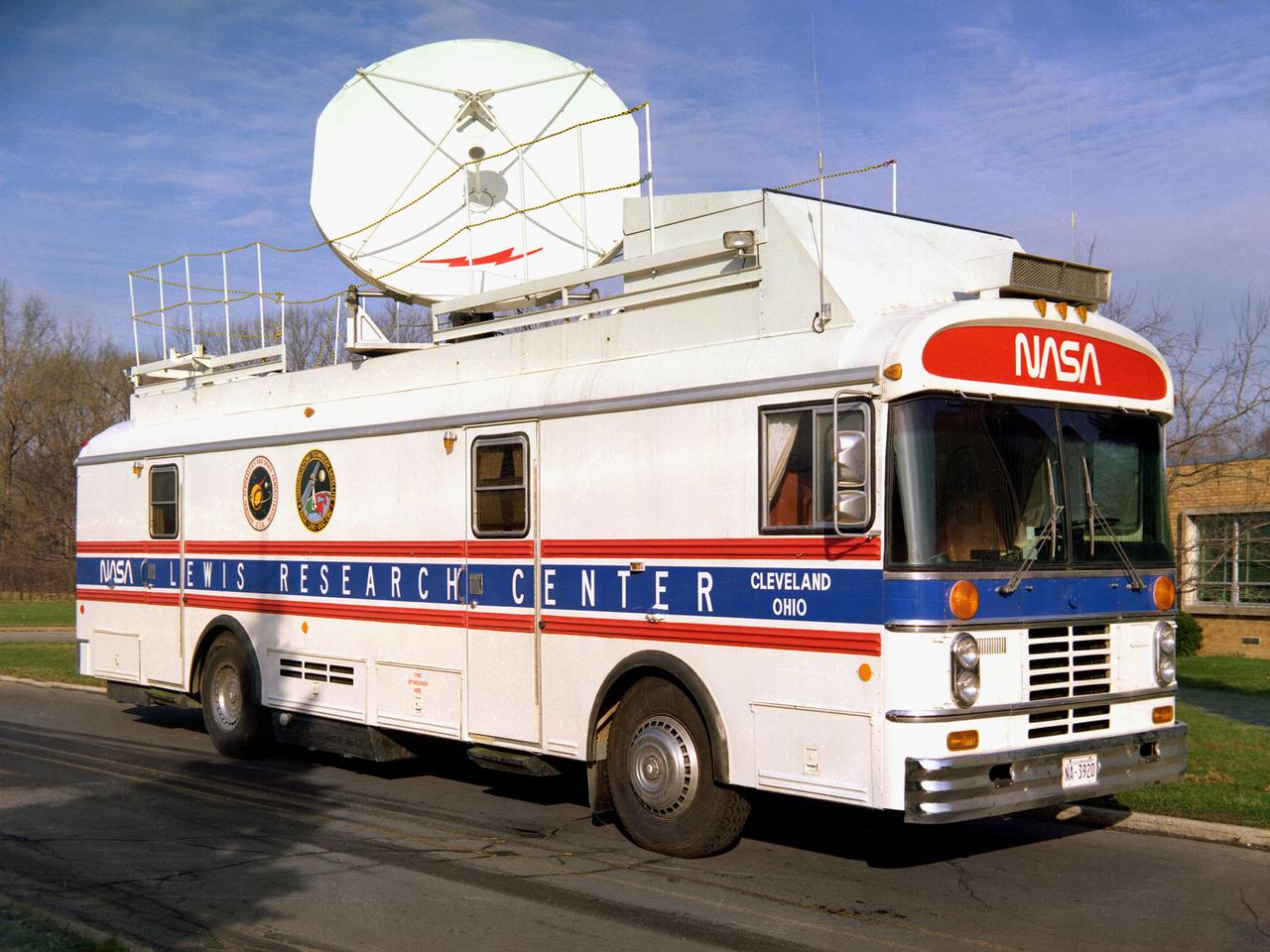
This vehicle served as a mobile terminal for the Communications Technology Satellite. The Communications Technology Satellite was an experimental communications satellite launched in January 1976 by the National Aeronautics and Space Administration (NASA) and the Canadian Department of Communications. The satellite operated in a new frequency band reserved for broadcast satellites with transmitting power levels that were 10 to 20 times higher than those of contemporary satellites. Throughout 1977 and 1978 NASA allowed qualified groups to utilize the satellite from one of the three ground-based transmission centers. NASA’s Lewis Research Center in Cleveland, Ohio was NASA’s lead center on the project. Lewis was responsible for the control and coordination of all US experiments on the satellite. The center housed the satellite’s main control center which included eight parabolic reflector antennae ranging from 2 to 15 feet in diameter. Many of the satellite’s components had been tested in simulated space conditions at Lewis. The Lewis-designed vehicle seen here served as a field unit for transmitting and receiving wideband signals and narrowband voice. The vehicle permitted live television interviews, recording equipment, and cameras. An 8-foot diameter parabolic reflector was mounted on the roof. The interior of the vehicle had workstations, monitors, transmitting equipment, and a lounge area.
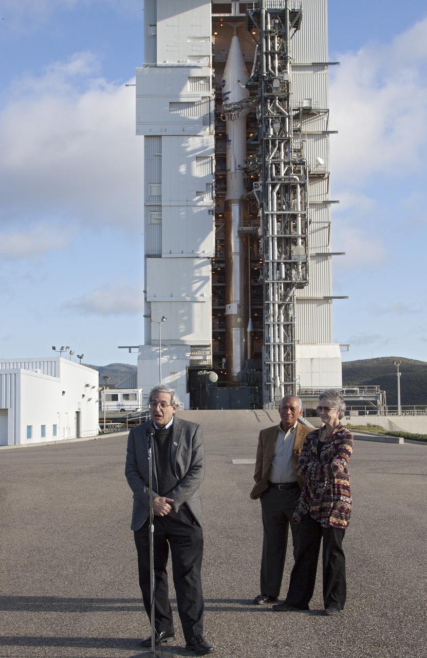
VANDENBERG AFB, Calif. -- At Space Launch Complex 3E at Vandenberg Air Force Base, Michael Freilich, director of the Earth Science Division, Science Mission Directorate, at NASA Headquarters, discuss the Landsat Data Continuity Mission, or LDCM, satellite mission with NASA social media followers. Looking on, to the right, is NASA Administrator Charles Bolden, left, and Anne Castle, assistant secretary for Water and Science, U.S. Department of the Interior. The Landsat Data Continuity Mission LDCM is the future of Landsat satellites. It will continue to obtain valuable data and imagery to be used in agriculture, education, business, science, and government. The Landsat Program provides repetitive acquisition of high resolution multispectral data of the Earth's surface on a global basis. The data from the Landsat spacecraft constitute the longest record of the Earth's continental surfaces as seen from space. It is a record unmatched in quality, detail, coverage, and value. Liftoff is planned for Feb. 11, 2013 aboard a United Launch Alliance Atlas V rocket. For more information, visit: http:__www.nasa.gov_mission_pages_landsat_main_index.html Photo credit: NASA_Kim Shiflett

VANDENBERG AIR FORCE BASE, Calif. -- Media attending a post-launch news conference at Vandenberg Air Force Base, Calif. heard from officials who described the successful launch of the Landsat Data Continuity Mission, or LDCM. From the left are: Ken Schwer, LDCM project manager Goddard Space Flight Center, Greenbelt, Md., Michael Luther, deputy associate administrator for programs, Science Mission Directorate, at NASA Headquarters, Michael Freilich, director of the Earth Science Division, Science Mission Directorate at Headquarters, Anne Castle, assistant secretary for Water and Science, U.S. Department of the Interior, and Marsha McNutt, director of the U.S. Geological Survey. The Landsat Data Continuity Mission LDCM is the future of Landsat satellites. It will continue to obtain valuable data and imagery to be used in agriculture, education, business, science, and government. The Landsat Program provides repetitive acquisition of high resolution multispectral data of the Earth's surface on a global basis. The data from the Landsat spacecraft constitute the longest record of the Earth's continental surfaces as seen from space. It is a record unmatched in quality, detail, coverage, and value. Liftoff took place at 10:02 a.m. PST 1:02 P.M. EST) on Feb. 11, 2013 aboard a United Launch Alliance Atlas V rocket. For more information, visit: http:__www.nasa.gov_mission_pages_landsat_main_index.html Photo credit: NASA_Kim Shiflett
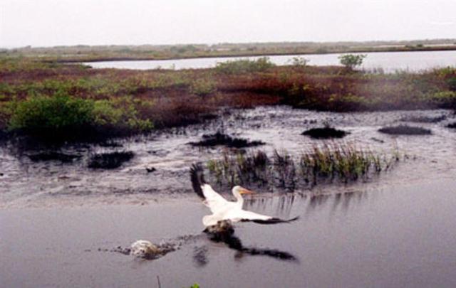
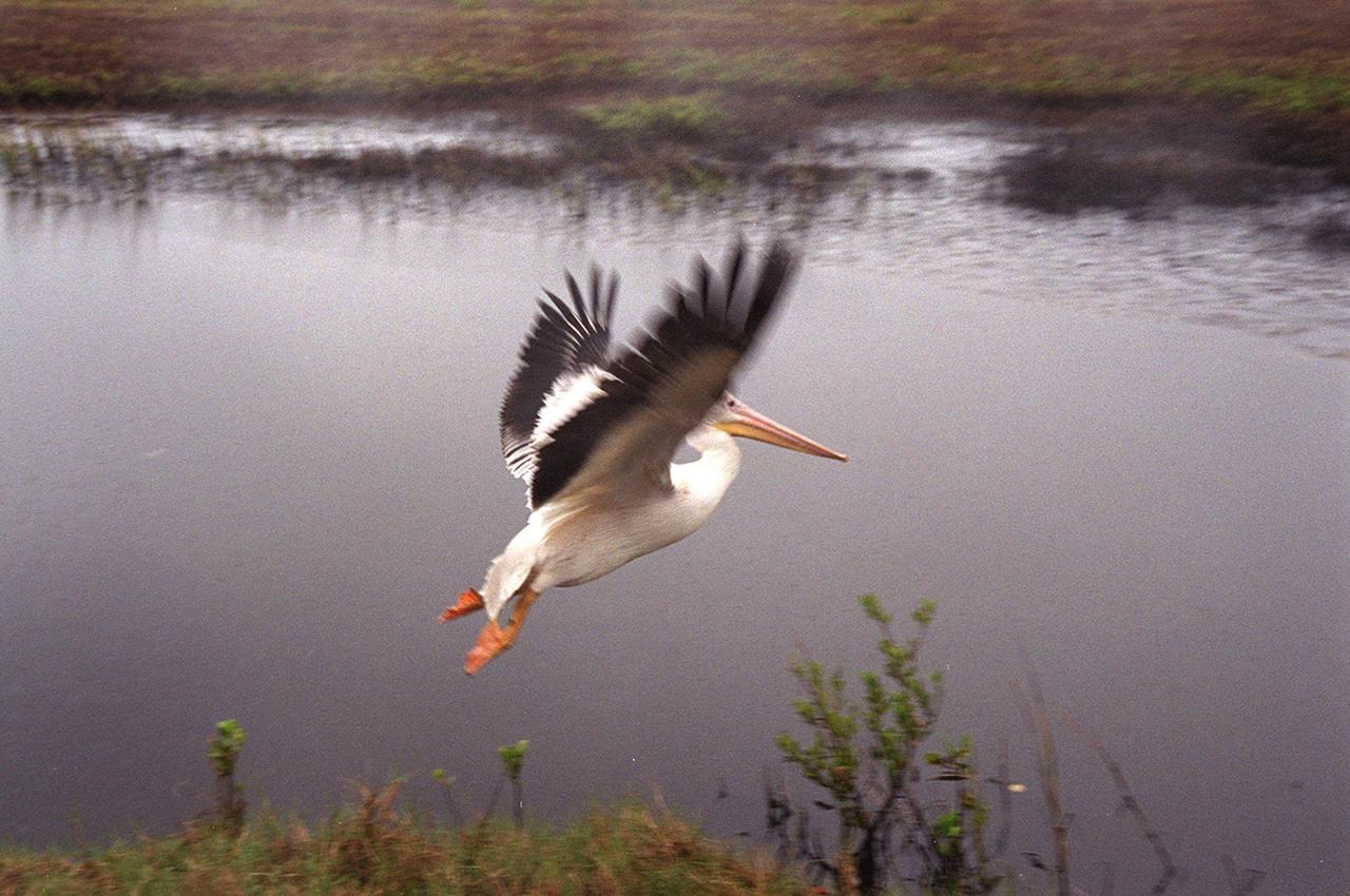
KENNEDY SPACE CENTER, FLA. -- A white pelican named "Fisheater" by its rescuers soars to open water in the Merritt Island National Wildlife Refuge as it flies to freedom. The pelican was found covered in crude oil from a contaminated ditch in northern Indiana in November, and was rescued by a local Police Department, treated, and flown to the Back to Nature Wildlife Refuge in Orlando, Fla. for care and rest. It is being released today to join a flock of about 30 other white pelicans that are wintering on the refuge, some of which are nearby. Before its release, however, Kat Royer, with the U.S. Fish and Wildlife Service, placed on it a leg band issued by the U.S. Department of the Interior's Bird Banding Laboratory. White pelicans inhabit marshy lakes and along the Pacific and Texas coasts. They winter from Florida and southern California south to Panama, chiefly in coastal lagoons. They are frequently seen flying in long lines, flapping and sailing in unison, but also ride rising air currents to soar gracefully in circles. The Merritt Island National Wildlife Refuge, which encompasses 92,000 acres that are a habitat for more than 331 species of birds, 31 mammals, 117 fishes, and 65 amphibians and reptiles. The marshes and open water of the refuge provide wintering areas for 23 species of migratory waterfowl, as well as a year-round home for great blue herons, great egrets, wood storks, cormorants, brown pelicans and other species of marsh and shore birds, as well as a variety of insects.

A rescued white pelican, dubbed "Fisheater" by his rescuers, takes a tentative step and stretches its wings after being let go at the Merritt Island National Wildlife Refuge. Looking on is Mark Epstein, with the U.S. Fish and Wildlife Service, who had held the bird while Kat Royer, also with the U.S. Fish and Wildlife Service, placed on it a leg band issued by the U.S. Department of the Interior's Bird Banding Laboratory. The pelican was found covered in crude oil from a contaminated ditch in northern Indiana in November, and was rescued by a local Police Department, treated, and flown to the Back to Nature Wildlife Refuge in Orlando, Fla. for care and rest. It is being released to join a flock of about 30 other white pelicans that are wintering on the refuge. White pelicans inhabit marshy lakes and along the Pacific and Texas coasts. They winter from Florida and southern California south to Panama, chiefly in coastal lagoons. They are frequently seen flying in long lines, flapping and sailing in unison, but also ride rising air currents to soar gracefully in circles. The Merritt Island National Wildlife Refuge, which encompasses 92,000 acres that are a habitat for more than 331 species of birds, 31 mammals, 117 fishes, and 65 amphibians and reptiles. The marshes and open water of the refuge provide wintering areas for 23 species of migratory waterfowl, as well as a year-round home for great blue herons, great egrets, wood storks, cormorants, brown pelicans and other species of marsh and shore birds, as well as a variety of insects
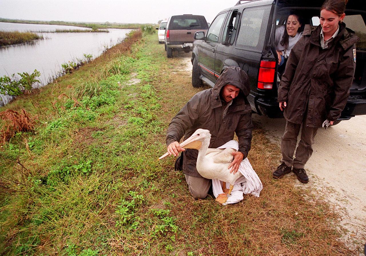
Under a rain-filled sky, Mark Epstein, with the U.S. Fish and Wildlife Service, gets ready to release a rescued white pelican. At right is Kat Royer, also with the U.S. Fish and Wildlife Service, who has fixed on it a leg band issued by the U.S. Department of the Interior's Bird Banding Laboratory. In the background is Christine Wise who is involved with rescue and rehabilitation of Florida wild animals. Wise brought the pelican to the Merritt Island National Wildlife Refuge for its release. The bird was found covered in crude oil from a contaminated ditch in northern Indiana in November, and was rescued by a local Police Department, treated, and flown to the Back to Nature Wildlife Refuge in Orlando, Fla. for care and rest. The pelican, dubbed "Fisheater" by its rescuers, is being let go to join a flock of about 30 other white pelicans that are wintering on the refuge. White pelicans inhabit marshy lakes and along the Pacific and Texas coasts. They winter from Florida and southern California south to Panama, chiefly in coastal lagoons. They are frequently seen flying in long lines, flapping and sailing in unison, but also ride rising air currents to soar gracefully in circles. The Merritt Island National Wildlife Refuge, which encompasses 92,000 acres that are a habitat for more than 331 species of birds, 31 mammals, 117 fishes, and 65 amphibians and reptiles. The marshes and open water of the refuge provide wintering areas for 23 species of migratory waterfowl, as well as a year-round home for great blue herons, great egrets, wood storks, cormorants, brown pelicans and other species of marsh and shore birds, as well as a variety of insects
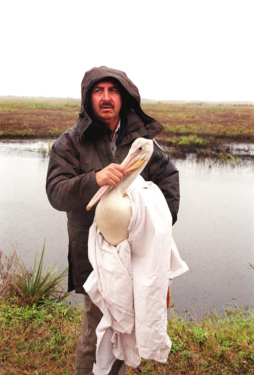
Mark Epstein, with the U.S. Fish and Wildlife Service, holds a white pelican that will be released under a rain-filled sky at the Merritt Island National Wildlife Refuge. The bird was found covered in crude oil from a contaminated ditch in northern Indiana in November, and was rescued by a local Police Department, treated, and flown to the Back to Nature Wildlife Center in Orlando, Fla. for care and rest. After Kat Royer, who is with the U.S. Fish and Wildlife Service, fits the bird with a leg band issued by the U.S. Department of the Interior's Bird Banding Laboratory, the pelican will be let go to join a flock of about 30 other white pelicans that are wintering on the refuge. White pelicans inhabit marshy lakes and along the Pacific and Texas coasts. They winter from Florida and southern California south to Panama, chiefly in coastal lagoons. They are frequently seen flying in long lines, flapping and sailing in unison, but also ride rising air currents to soar gracefully in circles. The Merritt Island National Wildlife Refuge, which encompasses 92,000 acres that are a habitat for more than 331 species of birds, 31 mammals, 117 fishes, and 65 amphibians and reptiles. The marshes and open water of the refuge provide wintering areas for 23 species of migratory waterfowl, as well as a year-round home for great blue herons, great egrets, wood storks, cormorants, brown pelicans and other species of marsh and shore birds, as well as a variety of insects
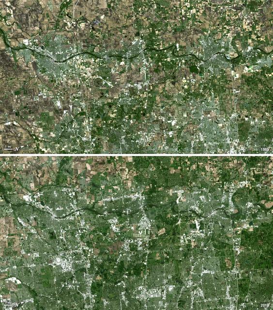
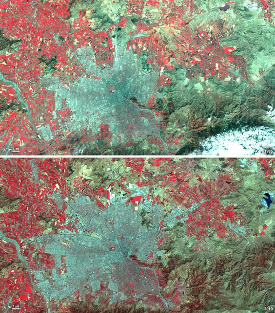
Forty miles west of downtown Chicago, the Fox River meanders its way through what has become the westernmost reaches of metropolitan Chicago, where the sprawling metropolis meets the hinterlands. While Chicago itself has seen a seven percent population decline during the last decade, the population of its metropolitan region, "Chicagoland," has steadily increased. These two natural-color Landsat 5 images acquired a quarter-century apart (on May 2, 1985, and May 23, 2010), stand witness to the soaring growth of this region. Aurora, Illinois’ second largest city, is the silvery-green region to the left hugging the Fox River, just south of the I-88 (North is to the right in this image); Carpentersville is found on the rightmost side, north of the I-90. From 1985 to 2010 a development explosion can been seen as the browns of pasture lands give way to silvery-green suburban areas and large white-colored business districts spring up along and east of the river. A major expansion of Dupage Airport appears in the middle of the 2010 image, and the circular-shaped region north of the I-88 and east of the Fox River, visible on both images, is the Department of Energy’s Fermilab. ---- NASA and the U.S. Department of the Interior through the U.S. Geological Survey (USGS) jointly manage Landsat, and the USGS preserves a 40-year archive of Landsat images that is freely available over the Internet. The next Landsat satellite, now known as the Landsat Data Continuity Mission (LDCM) and later to be called Landsat 8, is scheduled for launch in 2013. In honor of Landsat’s 40th anniversary in July 2012, the USGS released the LandsatLook viewer – a quick, simple way to go forward and backward in time, pulling images of anywhere in the world out of the Landsat archive. <b><a href="http://www.nasa.gov/audience/formedia/features/MP_Photo_Guidelines.html" rel="nofollow">NASA image use policy.</a></b> <b><a href="http://www.nasa.gov/centers/goddard/home/index.html" rel="nofollow">NASA Goddard Space Flight Center</a></b> enables NASA’s mission through four scientific endeavors: Earth Science, Heliophysics, Solar System Exploration, and Astrophysics. Goddard plays a leading role in NASA’s accomplishments by contributing compelling scientific knowledge to advance the Agency’s mission. <b>Follow us on <a href="http://twitter.com/NASA_GoddardPix" rel="nofollow">Twitter</a></b> <b>Like us on <a href="http://www.facebook.com/pages/Greenbelt-MD/NASA-Goddard/395013845897?ref=tsd" rel="nofollow">Facebook</a></b> <b>Find us on <a href="http://instagrid.me/nasagoddard/?vm=grid" rel="nofollow">Instagram</a></b>

SL4-93-153 (February 1974) --- A vertical view of the Birmingham and central Alabama area is seen in this Skylab 4 Earth Resources Experiments Package S190-B (five-inch earth terrain camera) infrared photographed taken from the Skylab space station in Earth orbit. Illustrated here is the utility of color infrared film in depicting distribution of living vegetation in the 3,600 square mile Birmingham region. The Birmingham industrial complex, with a population of nearly 850,000, is the light gray area nestled in the valley between the northeast-trending ridges that are prominent topographic features in the southern Appalachian Mountains. The narrow ridges and adjacent valleys reflect folded and faulted sedimentary rocks, indicating the complex geological history of the region. Two major rivers and several reservoirs are easily distinguished in this photograph. Bankhand Lake, formed by a dam on the Black Warrior River, appears as bright blue west of Birmingham. Two lakes are formed by dams on the Goosa River east of Birmingham. Federal and state highways appear as thin white lines and are easily identified. Interstate 65 to Montgomery is the prominent white line extending southward from Birmingham. Power line clearings are visible in the center of the picture along the Goosa River, and can be traced northwestward to northern parts of Birmingham. The predominant deep red color of the picture is due to the reflections from living vegetation. In contrast are the light tan areas that commonly occur as rectangular patterns in the east part of the photograph and represent mature agricultural crops or grazing lands. Analysis of the photographic data from the earth terrain camera will be conducted by Dr. H. Jayroe of the Marshall Space Flight Center in developing analytical techniques. All EREP photography is available to the public through the Department of Interior's Earth Resources Observations Systems Data Center, Sioux Falls, South Dakota, 57198. Photo credit: NASA

Istanbul has been a bustling trade city for thousands of years. In this 1975 image, taken by Landsat, the city centers on the Golden Horn the estuary that flows into the Bosporus Straight at the center of the scene. Shown in false color, vegetation is red, urban areas are gray, and water appears black. A bridge built in 1973 to connect the Asian and European sides of Istanbul is barely visible. By 2011, Istanbul's population had exploded from 2 to 13 million people, and the city has gone through a dramatic expansion. This Landsat 5 image shows densely packed urban areas stretching along the Sea of Marmara and up the Bosporus Straight where a second bridge built in 1988 now crosses the water. ---- NASA and the U.S. Department of the Interior through the U.S. Geological Survey (USGS) jointly manage Landsat, and the USGS preserves a 40-year archive of Landsat images that is freely available over the Internet. The next Landsat satellite, now known as the Landsat Data Continuity Mission (LDCM) and later to be called Landsat 8, is scheduled for launch in 2013. In honor of Landsat’s 40th anniversary in July 2012, the USGS released the LandsatLook viewer – a quick, simple way to go forward and backward in time, pulling images of anywhere in the world out of the Landsat archive. <b><a href="http://www.nasa.gov/audience/formedia/features/MP_Photo_Guidelines.html" rel="nofollow">NASA image use policy.</a></b> <b><a href="http://www.nasa.gov/centers/goddard/home/index.html" rel="nofollow">NASA Goddard Space Flight Center</a></b> enables NASA’s mission through four scientific endeavors: Earth Science, Heliophysics, Solar System Exploration, and Astrophysics. Goddard plays a leading role in NASA’s accomplishments by contributing compelling scientific knowledge to advance the Agency’s mission. <b>Follow us on <a href="http://twitter.com/NASA_GoddardPix" rel="nofollow">Twitter</a></b> <b>Like us on <a href="http://www.facebook.com/pages/Greenbelt-MD/NASA-Goddard/395013845897?ref=tsd" rel="nofollow">Facebook</a></b> <b>Find us on <a href="http://instagrid.me/nasagoddard/?vm=grid" rel="nofollow">Instagram</a></b>
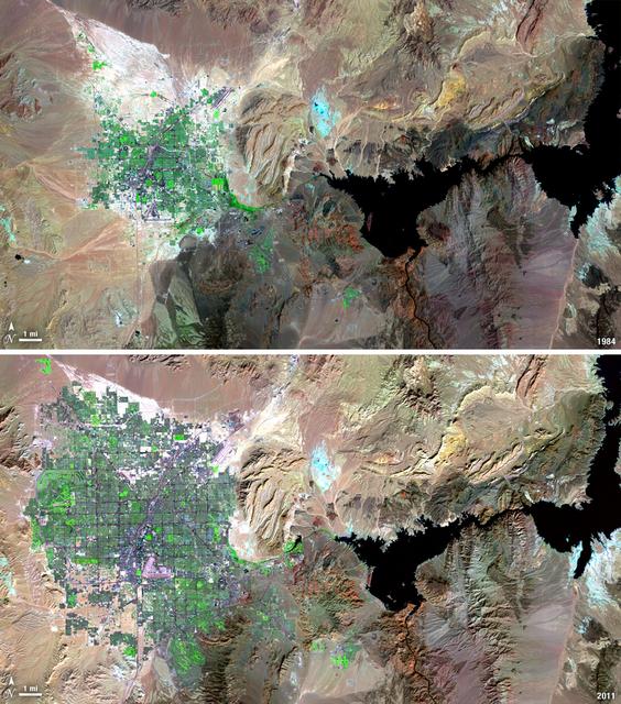
Over the years of the Landsat program, the desert city of Las Vegas has gone through a massive growth spurt. The outward expansion of the city over the last quarter of a century is shown here with two false-color Landsat 5 images (August 3, 1984, and November 2, 2011). The dark purple grid of city streets and the green of irrigated vegetation grow out in every direction into the surrounding desert. These images were created using reflected light from the shortwave infrared, near-infrared, and green portions of the electromagnetic spectrum (Landsat 5 TM bands 7,4,2). ---- NASA and the U.S. Department of the Interior through the U.S. Geological Survey (USGS) jointly manage Landsat, and the USGS preserves a 40-year archive of Landsat images that is freely available over the Internet. The next Landsat satellite, now known as the Landsat Data Continuity Mission (LDCM) and later to be called Landsat 8, is scheduled for launch in 2013. In honor of Landsat’s 40th anniversary in July 2012, the USGS released the LandsatLook viewer – a quick, simple way to go forward and backward in time, pulling images of anywhere in the world out of the Landsat archive. <b><a href="http://www.nasa.gov/audience/formedia/features/MP_Photo_Guidelines.html" rel="nofollow">NASA image use policy.</a></b> <b><a href="http://www.nasa.gov/centers/goddard/home/index.html" rel="nofollow">NASA Goddard Space Flight Center</a></b> enables NASA’s mission through four scientific endeavors: Earth Science, Heliophysics, Solar System Exploration, and Astrophysics. Goddard plays a leading role in NASA’s accomplishments by contributing compelling scientific knowledge to advance the Agency’s mission. <b>Follow us on <a href="http://twitter.com/NASA_GoddardPix" rel="nofollow">Twitter</a></b> <b>Like us on <a href="http://www.facebook.com/pages/Greenbelt-MD/NASA-Goddard/395013845897?ref=tsd" rel="nofollow">Facebook</a></b> <b>Find us on <a href="http://instagrid.me/nasagoddard/?vm=grid" rel="nofollow">Instagram</a></b>
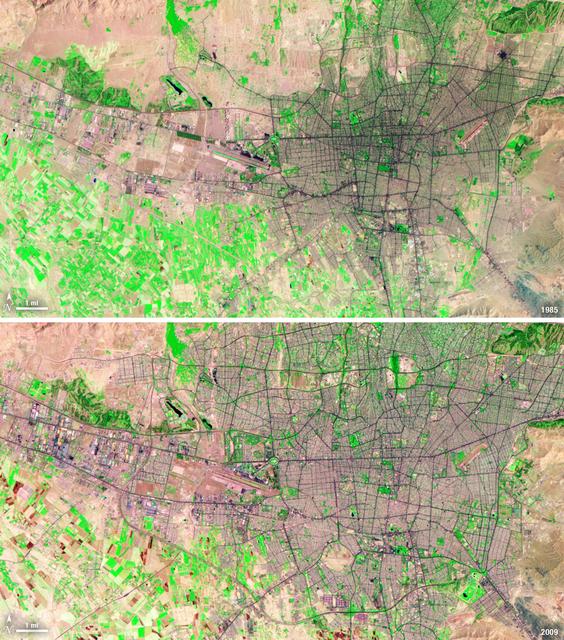
Between 1985 and 2009, the population of Tehran, Iran, grew from six million to just over seven million. The city's growth was spurred largely by migration from other parts of the country. In addition to being the hub of government and associated public sector jobs, Tehran houses more than half of Iran's industry. Landsat 5 acquired these false-color images of Tehran on August 2, 1985, and July 19, 2009. The city is a web of dark purple lines, vegetation is green and bare ground is pink and tan. The images were created using both infrared and visible light (band combination 7, 4, and 2) to distinguish urban areas from the surrounding desert. ---- NASA and the U.S. Department of the Interior through the U.S. Geological Survey (USGS) jointly manage Landsat, and the USGS preserves a 40-year archive of Landsat images that is freely available over the Internet. The next Landsat satellite, now known as the Landsat Data Continuity Mission (LDCM) and later to be called Landsat 8, is scheduled for launch in 2013. In honor of Landsat’s 40th anniversary in July 2012, the USGS released the LandsatLook viewer – a quick, simple way to go forward and backward in time, pulling images of anywhere in the world out of the Landsat archive. <b><a href="http://www.nasa.gov/audience/formedia/features/MP_Photo_Guidelines.html" rel="nofollow">NASA image use policy.</a></b> <b><a href="http://www.nasa.gov/centers/goddard/home/index.html" rel="nofollow">NASA Goddard Space Flight Center</a></b> enables NASA’s mission through four scientific endeavors: Earth Science, Heliophysics, Solar System Exploration, and Astrophysics. Goddard plays a leading role in NASA’s accomplishments by contributing compelling scientific knowledge to advance the Agency’s mission. <b>Follow us on <a href="http://twitter.com/NASA_GoddardPix" rel="nofollow">Twitter</a></b> <b>Like us on <a href="http://www.facebook.com/pages/Greenbelt-MD/NASA-Goddard/395013845897?ref=tsd" rel="nofollow">Facebook</a></b> <b>Find us on <a href="http://instagrid.me/nasagoddard/?vm=grid" rel="nofollow">Instagram</a></b>
S73-35080 (July-September 1973) --- A vertical view of northeast Oklahoma and the metropolitan Tulsa area is seen in this Skylab 3 Earth Resources Experiments Package S190-B (five-inch Earth terrain camera) photograph taken from the Skylab space station in Earth orbit. THE PICTURE SHOULD BE HELD WITH THE CLOCK ON THE LEFT AND THE LAKE IN THE CORNER ON THE RIGHT. THE LONG STRETCH OF HIGHWAY (U.S. 75) RUNS STRAIGHT NORTH FROM TULSA. Tulsa, a rapidly expanding city in the heart of the mid-continent oil field, has a population of approximately 330,000. The Arkansas River meanders across the southern (lower) portion of the photograph passing through Tulsa as it flows southeastward. Oologah Reservoir, the long body of water, is located northeast of Tulsa. Lake Hudson is the body of water in the right corner of the picture. Keystone Reservoir is to the west and upstream from Tulsa. Westward from Tulsa U.S. 64 makes a 45 degree bend as it turns northwest to cross the Keystone Reservoir. The thin white line over the Oologah Reservoir is a highway bridge. Bartlesville is on U.S. 75 near the north (top) corner of the picture. The Tulsa International Airport is immediately northeast of downtown Tulsa. Several smaller airfields are visible in the surrounding area. The toll roads and other major highways are clearly visible in the picture. Claremore is northeast of Tulsa on U.S. 66 with the Will Rogers Turnpike passing nearby. Sapulpa is southwest of Tulsa on the Turner Turnpike which leads toward Oklahoma City. The detailed information contained in this photograph can be extracted by direct observation and applied to updating land use and cultural maps of Tulsa and to numerous surrounding satellite cities. All EREP photography is available to the public through the Department of Interior?s Earth Resources Observations Systems Data Center, Sioux Falls, South Dakota, 57198. (Alternate number SL3-83-206) Photo credit: NASA
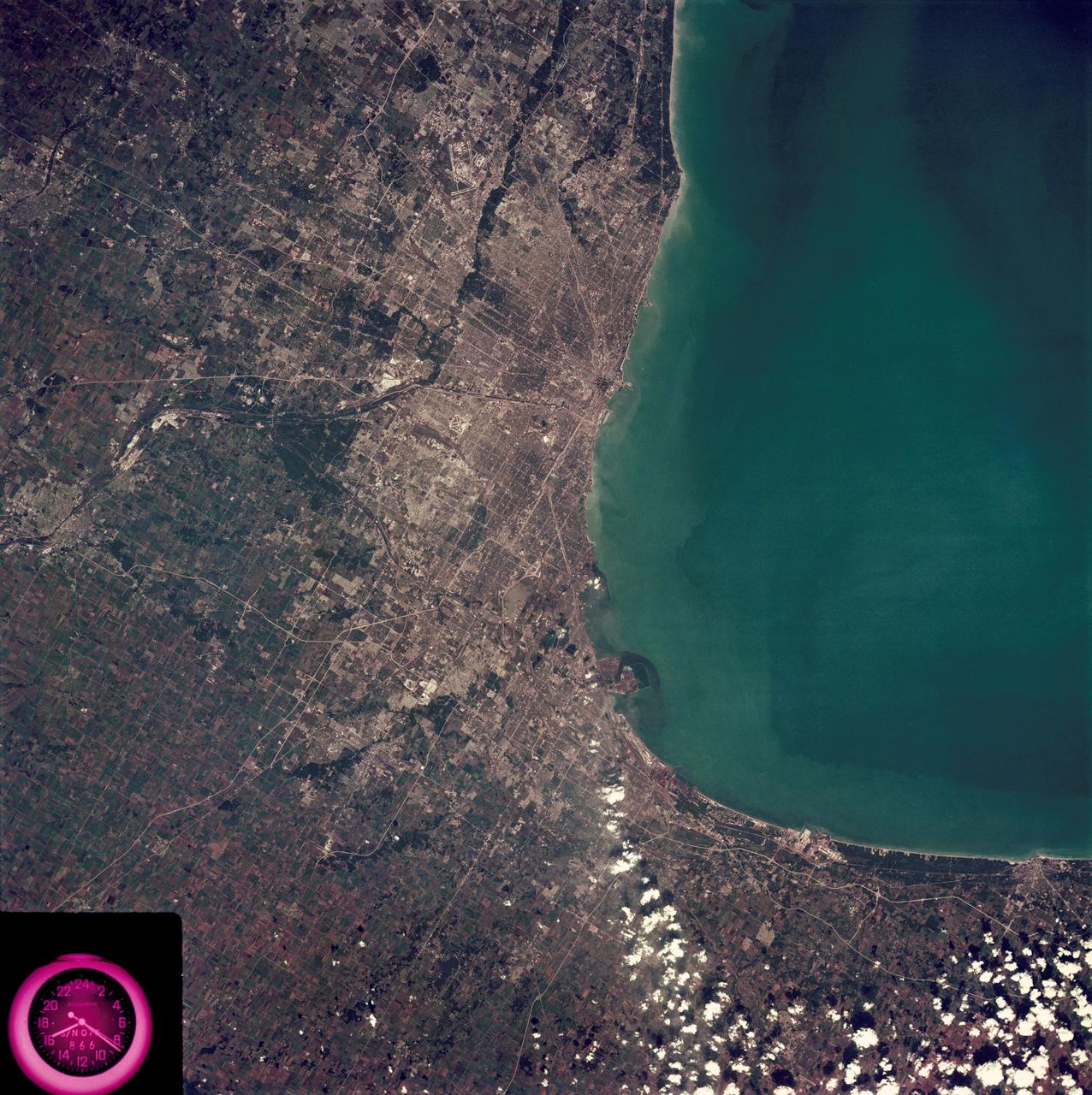
SL3-88-222 (18 Sept. 1973) --- The metropolitan area of Chicago is encompassed in this Skylab 3 Earth Resources Experiments Package (EREP) S190-B photograph taken on Sept. 18, 1973 from the Skylab space station cluster in Earth orbit. The surrounding major cities of Aurora and Joliet, Illinois; Hammond, Gary and East Chicago, Indiana, are easily delineated. The photograph reveals the following: (1) Cultural differentiation of commercial, industrial and residential areas for use in population and social studies in micro-macro community planning and in cultural pattern studies in the improvement of urban areas. (Aurora is one of 27 census cities of interest to Robert Alexander, a principal investigator. Alexander is with the U.S. Geological Survey). (2) The transportation network with major corridors and their interchanges, primary and feeder streets for use in network analysis and in the development of models for population movement and land use projection. (3) The agricultural lands for land use identification on crop inventory analysis; airports for use in delineation of service and infringement of major man-made features that affect ecosystem balance (support to environmental impact studies). (4) Air and water plumes for use in case studies, natural and man-made differentiation of pollution sources, in support of model development and in ecosystem research studies on the effects of pollution. (5) Recreational centers for use in relating recreational centers to population centers, establishing possible demands and in development of possible future recreational centers to support the demand. All EREP photography is available to the public through the Department of Interior?s Earth Resources Observations Systems Data Center, Sioux Falls, South Dakota, 57198. Photo credit: NASA
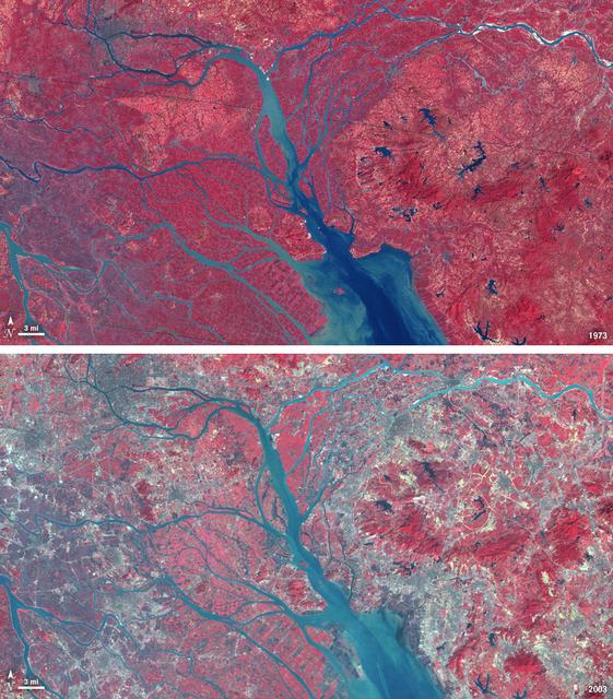
In 1979, China established two special economic zones around the Pearl River Delta, north of Hong Kong. This image, taken by Landsat 3 on October 19, 1973, shows that the region was rural when the zone was established. Plant-covered land, which is red in this false-color image, dominates the scene. Square grids are agriculture. By January 10, 2003, when Landsat 7 took this image, the Pearl River Delta was a densely populated urban corridor with several large cities. The urban areas are gray in this image. The region is a major manufacturing center with an economy the size of Taiwan’s. As of 2010, the Pearl River Economic Zone had a population of 36 million people. ---- NASA and the U.S. Department of the Interior through the U.S. Geological Survey (USGS) jointly manage Landsat, and the USGS preserves a 40-year archive of Landsat images that is freely available over the Internet. The next Landsat satellite, now known as the Landsat Data Continuity Mission (LDCM) and later to be called Landsat 8, is scheduled for launch in 2013. In honor of Landsat’s 40th anniversary in July 2012, the USGS released the LandsatLook viewer – a quick, simple way to go forward and backward in time, pulling images of anywhere in the world out of the Landsat archive. <b><a href="http://www.nasa.gov/audience/formedia/features/MP_Photo_Guidelines.html" rel="nofollow">NASA image use policy.</a></b> <b><a href="http://www.nasa.gov/centers/goddard/home/index.html" rel="nofollow">NASA Goddard Space Flight Center</a></b> enables NASA’s mission through four scientific endeavors: Earth Science, Heliophysics, Solar System Exploration, and Astrophysics. Goddard plays a leading role in NASA’s accomplishments by contributing compelling scientific knowledge to advance the Agency’s mission. <b>Follow us on <a href="http://twitter.com/NASA_GoddardPix" rel="nofollow">Twitter</a></b> <b>Like us on <a href="http://www.facebook.com/pages/Greenbelt-MD/NASA-Goddard/395013845897?ref=tsd" rel="nofollow">Facebook</a></b> <b>Find us on <a href="http://instagrid.me/nasagoddard/?vm=grid" rel="nofollow">Instagram</a></b>
Santiago, Chile, ranks among the world's fastest growing cities. Chile is South America's fifth largest economy with strong export and tourism markets. More than a third of Chile's population lives in Santiago as of 2009. Taken on January 9, 1985, and January 30, 2010, this pair of images from the Landsat 5 satellite illustrates the city's steady growth. The images were made with infrared and visible light (Landsat bands 4, 3, and 2) so that plant-covered land is red. Bare or sparsely vegetated land is tan, and the city is dark silver. In the fifteen years that elapsed between 1985 and 2010, the city expanded away from the Andes Mountains along spoke-like lines, which are major roads. ---- NASA and the U.S. Department of the Interior through the U.S. Geological Survey (USGS) jointly manage Landsat, and the USGS preserves a 40-year archive of Landsat images that is freely available over the Internet. The next Landsat satellite, now known as the Landsat Data Continuity Mission (LDCM) and later to be called Landsat 8, is scheduled for launch in 2013. In honor of Landsat’s 40th anniversary in July 2012, the USGS released the LandsatLook viewer – a quick, simple way to go forward and backward in time, pulling images of anywhere in the world out of the Landsat archive. <b><a href="http://www.nasa.gov/audience/formedia/features/MP_Photo_Guidelines.html" rel="nofollow">NASA image use policy.</a></b> <b><a href="http://www.nasa.gov/centers/goddard/home/index.html" rel="nofollow">NASA Goddard Space Flight Center</a></b> enables NASA’s mission through four scientific endeavors: Earth Science, Heliophysics, Solar System Exploration, and Astrophysics. Goddard plays a leading role in NASA’s accomplishments by contributing compelling scientific knowledge to advance the Agency’s mission. <b>Follow us on <a href="http://twitter.com/NASA_GoddardPix" rel="nofollow">Twitter</a></b> <b>Like us on <a href="http://www.facebook.com/pages/Greenbelt-MD/NASA-Goddard/395013845897?ref=tsd" rel="nofollow">Facebook</a></b> <b>Find us on <a href="http://instagrid.me/nasagoddard/?vm=grid" rel="nofollow">Instagram</a></b>
SL3-83-166 (July-September 1973) --- A vertical view of the Washington D.C. and the Baltimore, Maryland area is seen in the Skylab 3 Earth Resources Experiments Package S190-B (five-inch Earth terrain camera) photograph taken from the Skylab space station in Earth orbit. The Chesapeake Bay is on the right (east) side of the picture. The Potomac River flows through the Washington area in the lower left (southwest) corner of the photograph. Several transportation routes and major highways stand out very distinctly. Especially conspicuous are the beltways around the cities, Interstate 95 between Baltimore and the nation?s capitol and Interstate 70N leading west from Baltimore. The tunnel and harbor facilities in Baltimore show clearly, also. Identifiable features in the Washington area include the Capitol Building, the Mall area, Robert F. Kennedy Stadium (white circle), the five bridges across the Potomac, Andrews Air Force Base (on east loop), and the smaller Anacostia River. The extent of the urbanization in this area is dramatically illustrated in this picture. The photograph has sufficient resolution that the housing patterns for individual suburban areas are clearly defined with the houses shown as pink gray, wooded areas as dark green and cleared areas light green. Chesapeake Bay circulation patterns are indicated by contrast of dark and light blue. Sediment plumes (red) are seen entering the bay north and east of Baltimore. The bay bridge stands out white against the blue water. The detailed information contained in this one photograph will be of direct use to several EREP investigator teams in land use analysis, sedimentation and circulation patterns in the bay, and resource surveys of Maryland. All EREP photography is available to the public through the Department of Interior?s Earth Resources Observations Systems Data Center, Sioux Falls, South Dakota, 57198. Photo credit: NASA
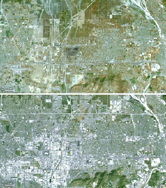
Thirty-five miles due east of downtown Los Angeles lies the city of Ontario, California. In 1881 two Canadian brothers established the town, naming it after their native city. By 1891 Ontario, Calif., was incorporated as a city. The farming-based economy (olives, citrus, dairy) of the city helped it grow to 20,000 by the 1960s. Subsequently, warehousing and freight trafficking took over as the major industry and the city’s population was over 160,000 by 2010. The L.A./Ontario International Airport is now America’s 15th busiest cargo airport. In these natural color Landsat 5 images, the massive growth of the city between 1985 and 2010 can be seen. The airport, found in the southwest portion of the images, added a number of runways and large warehousing structures now dominate the once rural areas surrounding the airport. In these images vegetation is green and brown and urban structures are bright white and gray. (Note there is a large dry riverbed in the northeast corner that is also bright white, but its nonlinear appearance sets it apart visually). ---- NASA and the U.S. Department of the Interior through the U.S. Geological Survey (USGS) jointly manage Landsat, and the USGS preserves a 40-year archive of Landsat images that is freely available over the Internet. The next Landsat satellite, now known as the Landsat Data Continuity Mission (LDCM) and later to be called Landsat 8, is scheduled for launch in 2013. In honor of Landsat’s 40th anniversary in July 2012, the USGS released the LandsatLook viewer – a quick, simple way to go forward and backward in time, pulling images of anywhere in the world out of the Landsat archive. <b><a href="http://www.nasa.gov/audience/formedia/features/MP_Photo_Guidelines.html" rel="nofollow">NASA image use policy.</a></b> <b><a href="http://www.nasa.gov/centers/goddard/home/index.html" rel="nofollow">NASA Goddard Space Flight Center</a></b> enables NASA’s mission through four scientific endeavors: Earth Science, Heliophysics, Solar System Exploration, and Astrophysics. Goddard plays a leading role in NASA’s accomplishments by contributing compelling scientific knowledge to advance the Agency’s mission. <b>Follow us on <a href="http://twitter.com/NASA_GoddardPix" rel="nofollow">Twitter</a></b> <b>Like us on <a href="http://www.facebook.com/pages/Greenbelt-MD/NASA-Goddard/395013845897?ref=tsd" rel="nofollow">Facebook</a></b> <b>Find us on <a href="http://instagrid.me/nasagoddard/?vm=grid" rel="nofollow">Instagram</a></b>
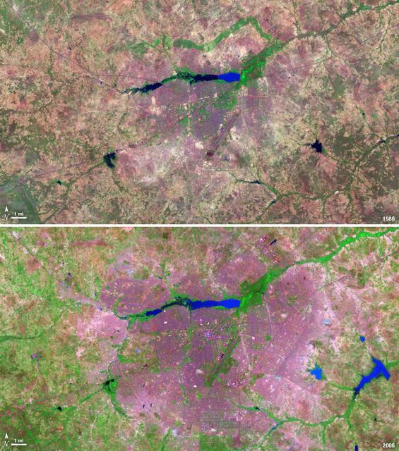
The landlocked western African nation of Burkina Faso experienced a 200 percent increase in urban population between 1975 and 2000. As a result, the area of the capital city Ouagadougou grew 14-fold during this period. These Landsat images show the city expanding outward from its center in the two decades between 1986 and 2006. On Nov. 18, 1986, the Landsat 5 satellite acquired this image of the capital. This false-color image shows vegetation in shades of green and gray, water in various shades of blue, and urban areas in pink and purple. The runway of the city’s airport can be seen as a long straight line that extends from southwest to northeast south of the large lake, Bois de Boulogne. Two decades later, on Oct. 16, 2006 Landsat 7 acquired this image of Ouagadougou. Growth radiated from the city center in all directions. The green strip of vegetation north of Bois de Boulogne has been paved over and a massive new development including a large thoroughfare and traffic circle can be seen south of the airport. ---- NASA and the U.S. Department of the Interior through the U.S. Geological Survey (USGS) jointly manage Landsat, and the USGS preserves a 40-year archive of Landsat images that is freely available over the Internet. The next Landsat satellite, now known as the Landsat Data Continuity Mission (LDCM) and later to be called Landsat 8, is scheduled for launch in 2013. In honor of Landsat’s 40th anniversary in July 2012, the USGS released the LandsatLook viewer – a quick, simple way to go forward and backward in time, pulling images of anywhere in the world out of the Landsat archive. <b><a href="http://www.nasa.gov/audience/formedia/features/MP_Photo_Guidelines.html" rel="nofollow">NASA image use policy.</a></b> <b><a href="http://www.nasa.gov/centers/goddard/home/index.html" rel="nofollow">NASA Goddard Space Flight Center</a></b> enables NASA’s mission through four scientific endeavors: Earth Science, Heliophysics, Solar System Exploration, and Astrophysics. Goddard plays a leading role in NASA’s accomplishments by contributing compelling scientific knowledge to advance the Agency’s mission. <b>Follow us on <a href="http://twitter.com/NASA_GoddardPix" rel="nofollow">Twitter</a></b> <b>Like us on <a href="http://www.facebook.com/pages/Greenbelt-MD/NASA-Goddard/395013845897?ref=tsd" rel="nofollow">Facebook</a></b> <b>Find us on <a href="http://instagrid.me/nasagoddard/?vm=grid" rel="nofollow">Instagram</a></b>
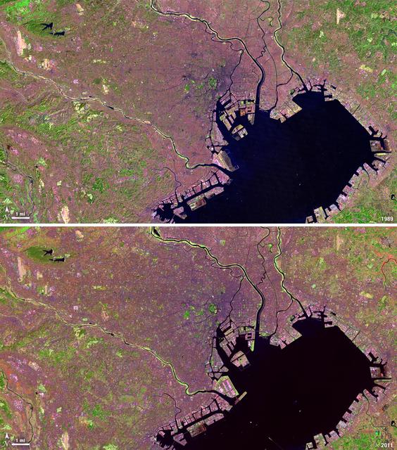
Tokyo is the world’s largest metropolitan region, home to nearly 37 million people. During the past two decades, Tokyo’s population has grown by more than 7 million. The city’s growth has continued despite Japan’s overall stagnating population, mainly due to a continued trend of centralization—citizens moving out of the country and into the city. Landsat 4 collected this first false-color image of Tokyo on Feb. 2, 1989. The upper half of Tokyo Bay is the large water body visible in a dark blue. In the middle of the image, central Tokyo appears a deep purple just north of the bay. Twenty-two years later, Landsat 5, captured this second image of Tokyo on April 5, 2011. The urban reaches of metropolitan Tokyo have grown in both distance and density, as seen where the green color of vegetation has turned to pink and purple shades of urbanization. A major expansion of Tokyo’s Haneda Airport, can be seen south of the city, on land built out into the bay. The constant circular spot of green in the dense city-center, visible on both images, is the Tokyo Imperial Palace and its gardens. (Landsat 5 TM Bands 7,4,2) ---- NASA and the U.S. Department of the Interior through the U.S. Geological Survey (USGS) jointly manage Landsat, and the USGS preserves a 40-year archive of Landsat images that is freely available over the Internet. The next Landsat satellite, now known as the Landsat Data Continuity Mission (LDCM) and later to be called Landsat 8, is scheduled for launch in 2013. In honor of Landsat’s 40th anniversary in July 2012, the USGS released the LandsatLook viewer – a quick, simple way to go forward and backward in time, pulling images of anywhere in the world out of the Landsat archive. <b><a href="http://www.nasa.gov/audience/formedia/features/MP_Photo_Guidelines.html" rel="nofollow">NASA image use policy.</a></b> <b><a href="http://www.nasa.gov/centers/goddard/home/index.html" rel="nofollow">NASA Goddard Space Flight Center</a></b> enables NASA’s mission through four scientific endeavors: Earth Science, Heliophysics, Solar System Exploration, and Astrophysics. Goddard plays a leading role in NASA’s accomplishments by contributing compelling scientific knowledge to advance the Agency’s mission. <b>Follow us on <a href="http://twitter.com/NASA_GoddardPix" rel="nofollow">Twitter</a></b> <b>Like us on <a href="http://www.facebook.com/pages/Greenbelt-MD/NASA-Goddard/395013845897?ref=tsd" rel="nofollow">Facebook</a></b> <b>Find us on <a href="http://instagrid.me/nasagoddard/?vm=grid" rel="nofollow">Instagram</a></b>