
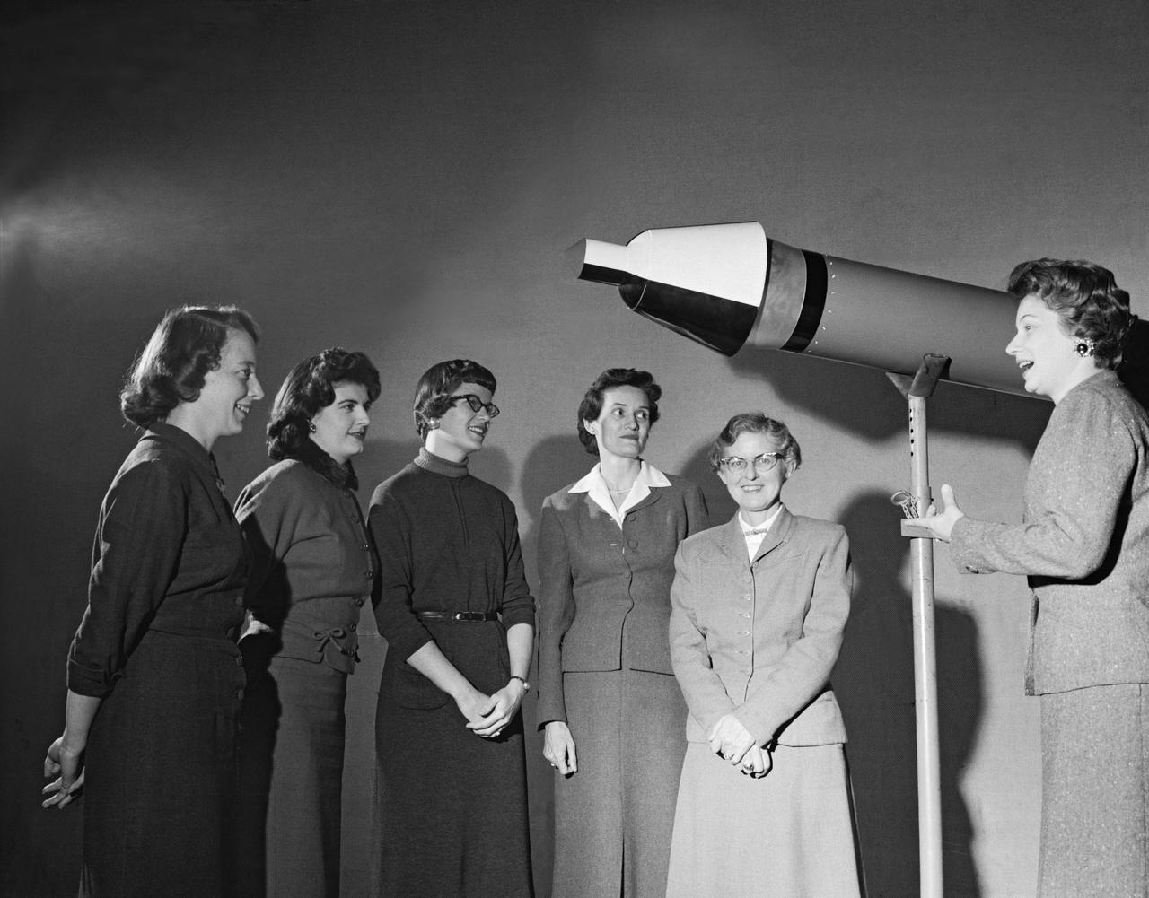
Women Adequately Filling Posts In NACA Laboratory: Mrs. Doris Rudd Porter Baron handling Manometertape, Bell computer.

Publicity Photos of Bell Computing Machines at 19 Foot Pressure Tunnel Mrs. Doris Rudd Porter Baron photographed in the photos.

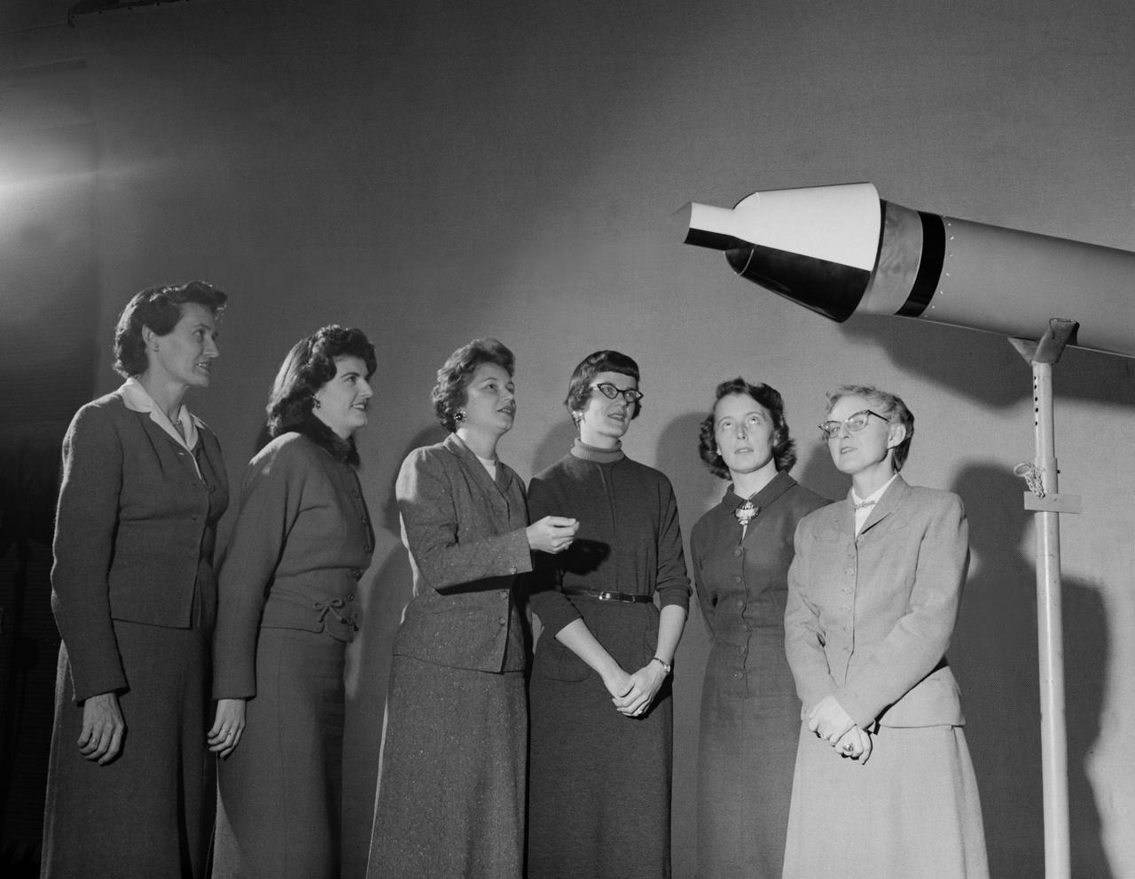
Publicity Photos of Bell Computing Machines at 19 Foot Pressure Tunnel Mrs. Doris Rudd Porter Baron photographed in the photos.

Publicity Photos of Bell Computing Machines at 19 Foot Pressure Tunnel Mrs. Doris Rudd Porter Baron photographed in the photos.

Publicity Photos of Bell Computing Machines at 19 Foot Pressure Tunnel Mrs. Doris Rudd Porter Baron photographed in the photos.

Publicity Photos of Bell Computing Machines at 19 Foot Pressure Tunnel Mrs. Doris Rudd Porter Baron photographed in the photos.

Publicity Photos of Bell Computing Machines at 19 Foot Pressure Tunnel Mrs. Doris Rudd Porter Baron photographed in the photos.
Women Scientists: Lucille Coltrane, Jean Clark Keating, Katherine Cullie Speegle, Doris "Dot" Lee, Ruth Whitman, and Emily Stephens Mueller,Lucille Coltrane is at the far left. She was a computer and worked for Norm Crabill who provided positive identification. Lucille authored a NACA Research Memorandum, Investigation of Two Bluff Shapes in Axial Free Flight Over a Mach Number Range From 0.35 to 2.15 in 1958. Next to Lucille is Jean Clark Keating. Jean was identified by Mary Woerner who said that both Jean and her husband Jerry are now deceased. The third woman from the left is Katherine Cullie Speegle. Katherine co-authored two research papers: Preliminary Results From a Free-Flight Investigation of Boundary-Layer Transition and Heat Transfer on a Highly Polished 8-Inch-Diameter Hemisphere-Cylinder at Mach Numbers up to 3 and Reynolds Numbers Based on a Length of 1 Foot up to 17.7 x 10 to the 6th and Heat Transfer For Mach Numbers Up to 2.2 and Pressure Distributions for Mach Numbers Up to 4.7 From Flight Investigations of a Flat-Face Cone and a Hemisphere-Cone. Norm remembered the woman standing as Doris. Mary Alice identified her as Doris 'Dot' Lee, who worked with Katherine Speegle. Dot was married to a NASA engineer named John Lee. Next to Doris is Ruth Whitman. Norm remembered she and her husband owned a Howard DGA 15 at the airport in WEst Point. That prompted Mary Alice to remember her name and that her husband was Jim. The woman seated on the right is Emily Stephens Mueller. Norm remembers that Emily went to Houston as part of the Space Task Group, but retired back here on the peninsula. In 2008, Emily attended the NACA Reunion X11. She walked over to a table of books about the history of NACA, former NACA facilities and the organization's aviation pioneers and saw a book about women of flight from the Dryden Research Center and paused, then pointed somewhat in amazement. "ThatÕs me," she said of a picture on the cover of her on the far left of a line of women. She was at Dryden from 1948-49.

Women Scientists: Lucille Coltrane, Jean Clark Keating, Katherine Cullie Speegle, Doris 'Dot' Lee, Ruth Whitman, and Emily Stephens Mueller,Lucille Coltrane is at the far left. She was a computer and worked for Norm Crabill who provided positive identification. Lucille authored a NACA Research Memorandum, Investigation of Two Bluff Shapes in Axial Free Flight Over a Mach Number Range From 0.35 to 2.15 in 1958. Next to Lucille is Jean Clark Keating. Jean was identified by Mary Woerner who said that both Jean and her husband Jerry are now deceased. The third woman from the left is Katherine Cullie Speegle. Katherine co-authored two research papers: Preliminary Results From a Free-Flight Investigation of Boundary-Layer Transition and Heat Transfer on a Highly Polished 8-Inch-Diameter Hemisphere-Cylinder at Mach Numbers up to 3 and Reynolds Numbers Based on a Length of 1 Foot up to 17.7 x 10 to the 6th and Heat Transfer For Mach Numbers Up to 2.2 and Pressure Distributions for Mach Numbers Up to 4.7 From Flight Investigations of a Flat-Face Cone and a Hemisphere-Cone. Norm remembered the woman standing as Doris. Mary Alice identified her as Doris 'Dot' Lee, who worked with Katherine Speegle. Dot was married to a NASA engineer named John Lee. Next to Doris is Ruth Whitman. Norm remembered she and her husband owned a Howard DGA 15 at the airport in WEst Point. That prompted Mary Alice to remember her name and that her husband was Jim. The woman seated on the right is Emily Stephens Mueller. Norm remembers that Emily went to Houston as part of the Space Task Group, but retired back here on the peninsula. In 2008, Emily attended the NACA Reunion X11. She walked over to a table of books about the history of NACA, former NACA facilities and the organization's aviation pioneers and saw a book about women of flight from the Dryden Research Center and paused, then pointed somewhat in amazement. "That’s me," she said of a picture on the cover of her on the far left of a li
Women Scientists: Lucille Coltrane, Jean Clark Keating, Katherine Cullie Speegle, Doris 'Dot' Lee, Ruth Whitman, and Emily Stephens Mueller,Lucille Coltrane is at the far left. She was a computer and worked for Norm Crabill who provided positive identification. Lucille authored a NACA Research Memorandum, Investigation of Two Bluff Shapes in Axial Free Flight Over a Mach Number Range From 0.35 to 2.15 in 1958. Next to Lucille is Jean Clark Keating. Jean was identified by Mary Woerner who said that both Jean and her husband Jerry are now deceased. The third woman from the left is Katherine Cullie Speegle. Katherine co-authored two research papers: Preliminary Results From a Free-Flight Investigation of Boundary-Layer Transition and Heat Transfer on a Highly Polished 8-Inch-Diameter Hemisphere-Cylinder at Mach Numbers up to 3 and Reynolds Numbers Based on a Length of 1 Foot up to 17.7 x 10 to the 6th and Heat Transfer For Mach Numbers Up to 2.2 and Pressure Distributions for Mach Numbers Up to 4.7 From Flight Investigations of a Flat-Face Cone and a Hemisphere-Cone. Norm remembered the woman standing as Doris. Mary Alice identified her as Doris 'Dot' Lee, who worked with Katherine Speegle. Dot was married to a NASA engineer named John Lee. Next to Doris is Ruth Whitman. Norm remembered she and her husband owned a Howard DGA 15 at the airport in WEst Point. That prompted Mary Alice to remember her name and that her husband was Jim. The woman seated on the right is Emily Stephens Mueller. Norm remembers that Emily went to Houston as part of the Space Task Group, but retired back here on the peninsula. In 2008, Emily attended the NACA Reunion X11. She walked over to a table of books about the history of NACA, former NACA facilities and the organization's aviation pioneers and saw a book about women of flight from the Dryden Research Center and paused, then pointed somewhat in amazement. "That’s me," she said of a picture on the cover of her on the far left of a li

Group shot of the nucleus of the 1960 Flight Operations Division for the Mercury Program. Image taken at the Houston Petroleum Center (HPC) in Houston, TX, prior to their move to the Manned Spacecraft Center (MSC). This photo was published in the Space News Roundup, 07/08/1964. The women are (L-R): Doris Folkes, Cathy Osgood, Shirley Hunt and Mary Shep Burton. The men are (L-R): Dick Koos, Paul Brumberg, John O'Loughlin, Emil Schiesser, Jim Dalby, Morris Jenkins, Carl Huss, John Mayer, Bill Tindall, Hal Beck, Charlie Allen, Ted Skopinski, Jack Hartung, Glynn Lunney, John Shoosmith, Bill Reini, Lyn Dunseith, Jerry Engel, Harold Miller and Clay Hicks. ( 26644 ); Houston, TX
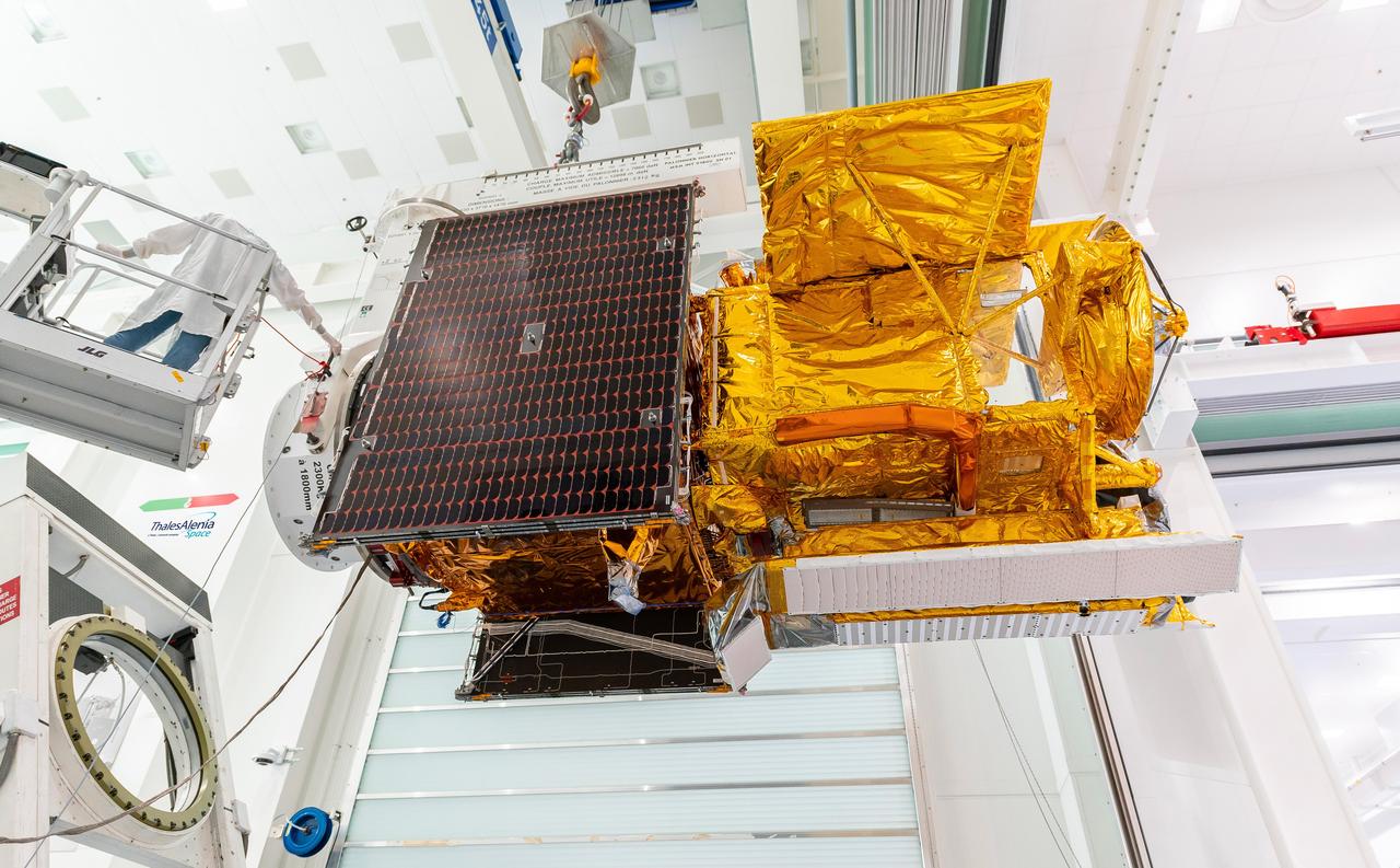
Workers in a clean room in Cannes, France, load the Surface Water and Ocean Topography (SWOT) satellite into a container in preparation for shipping the spacecraft to the U.S. SWOT is an international mission led by NASA and the French space agency Centre National d'Études Spatiales (CNES) that will survey water on more than 90% of Earth's surface. The spacecraft will view water in Earth's lakes, rivers, reservoirs, and the ocean in higher definition than ever before. The information that SWOT gathers will help inform water management decisions and prepare communities for rising seas and changing coastlines. It will also help researchers better understand the exchange of heat and carbon between the ocean and atmosphere, an important component of the role that Earth's ocean plays in the planet's climate. SWOT will launch out of the Vandenberg Space Force Base in central California no earlier than Dec. 5, 2022. SWOT is being jointly developed by NASA and CNES, with contributions from the Canadian Space Agency and the United Kingdom Space Agency. JPL, which is managed for NASA by Caltech in Pasadena, California, leads the U.S. component of the project. For the flight system payload, NASA is providing the KaRIn instrument, a GPS science receiver, a laser retroreflector, a two-beam microwave radiometer, and NASA instrument operations. CNES is providing the Doppler Orbitography and Radioposition Integrated by Satellite (DORIS) system, the dual frequency Poseidon altimeter (developed by Thales Alenia Space), the KaRIn radio-frequency subsystem (together with Thales Alenia Space and with support from the UK Space Agency), the platform, and ground control segment. CSA is providing the KaRIn high-power transmitter assembly. NASA is providing the launch vehicle and associated launch services. https://photojournal.jpl.nasa.gov/catalog/PIA24910
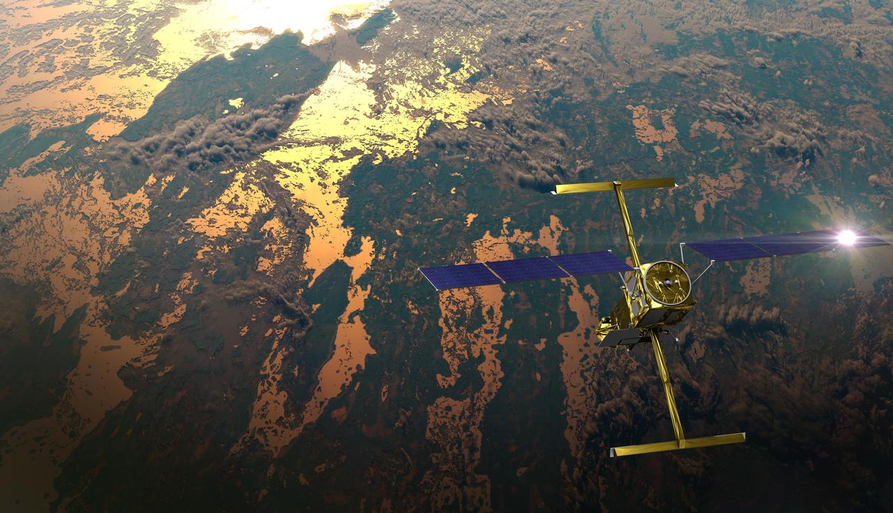
The international Surface Water and Ocean Topography (SWOT) satellite is shown in orbit over Earth in this illustration, with sunlight glinting off one of its solar arrays and both antennas of its Ka-band Radar Interferometer (KaRIn) instrument extended. The mission is a collaborative effort between NASA and the French space agency Centre National d'Études Spatiales (CNES) – with contributions from the Canadian Space Agency (CSA) and the UK Space Agency. KaRIn is the scientific heart of the SWOT satellite, which will survey the water on more than 90% of Earth's surface, measuring the height of water in lakes, rivers, reservoirs, and the ocean. To do that, KaRIn will transmit radar pulses to Earth's surface and use its two antennas to triangulate the return signals that bounce back. Mounted at the ends of a boom 33 feet (10 meters) long, the antennas will collect data along a swath 30 miles (50 kilometers) wide on either side of the satellite. KaRIn will operate in two modes: A lower-resolution mode over the ocean will involve significant onboard processing of the data to reduce the volume of information sent during downlinks to Earth; a higher-resolution mode will be used mainly over land. Scheduled to launch from Vandenberg Space Force Base in Central California on Dec. 15, 2022, SWOT is being jointly developed by NASA and CNES, with contributions from the CSA and the UK Space Agency. NASA's Jet Propulsion Laboratory, which is managed for the agency by Caltech in Pasadena, California, leads the U.S. component of the project. For the flight system payload, NASA is providing the Ka-band Radar Interferometer (KaRIn) instrument, a GPS science receiver, a laser retroreflector, a two-beam microwave radiometer, and NASA instrument operations. CNES is providing the Doppler Orbitography and Radioposition Integrated by Satellite (DORIS) system, the dual frequency Poseidon altimeter (developed by Thales Alenia Space), the KaRIn radio-frequency subsystem (together with Thales Alenia Space and with support from the UK Space Agency), the satellite platform, and ground control segment. CSA is providing the KaRIn high-power transmitter assembly. NASA is providing the launch vehicle and associated launch services. https://photojournal.jpl.nasa.gov/catalog/PIA25595
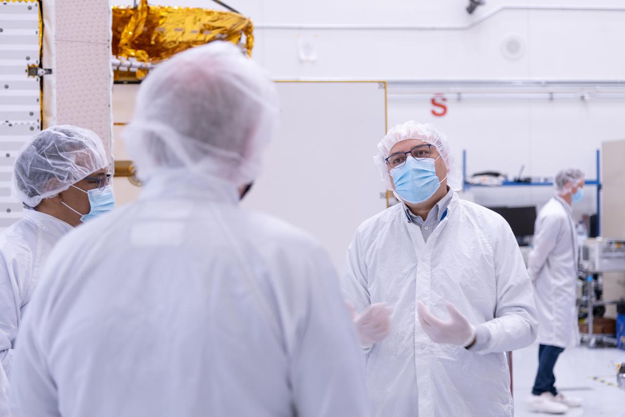
The new international satellite mission called Surface Water and Ocean Topography (SWOT) — slated for launch in late 2022 — will measure the height of Earth's surface water. The data the spacecraft will collect will help researchers understand and track the volume and location of water around the world. The satellite will assist with monitoring changes in floodplains and wetlands, measuring how much fresh water flows into and out of lakes and rivers and back to the ocean, and tracking regional shifts in sea level at scales never seen before. The satellite will also provide information on small-scale ocean currents that will support real-time marine operations affected by tides, currents, storm surge, sediment transport, and water quality issues. The payload is taking shape in a clean room at NASA's Jet Propulsion Laboratory in Southern California before being shipped to France. There, technicians and engineers from the French space agency Centre National d'Etudes Spatial (CNES), their prime contractor Thales Alenia Space, and JPL will complete the build and prepare the satellite for shipment to its California launch site at Vandenberg Air Force Base. JPL project manager Parag Vaze (pronounced vah-zay) is central to ensuring the handoff to his CNES counterpart Thierry Lafon goes smoothly. SWOT is being jointly developed by NASA and CNES, with contributions from the Canadian Space Agency (CSA) and United Kingdom Space Agency (UKSA). JPL, which is managed for NASA by Caltech in Pasadena, California, leads the U.S. component of the project. For the flight system, NASA is providing the Ka-band Radar Interferometer (KaRIn) instrument, a GPS science receiver, a laser retroreflector, and a two-beam microwave radiometer. CNES is providing the Doppler Orbitography and Radioposition Integrated by Satellite (DORIS) system, nadir altimeter, and the KaRIn RF subsystem (with support from the UKSA). CSA is providing the KaRIn high-power transmitter assembly. NASA is providing associated launch services. https://photojournal.jpl.nasa.gov/catalog/PIA24531
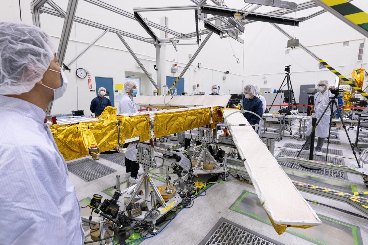
Members of the international Surface Water and Ocean Topography (SWOT) mission test one of the antennas for the Ka-band Radar Interferometer (KaRIn) instrument in a clean room at NASA's Jet Propulsion Laboratory in Southern California. The mission is a collaborative effort between NASA and the French space agency Centre National d'Études Spatiales (CNES) – with contributions from the Canadian Space Agency (CSA) and the UK Space Agency. KaRIn is the scientific heart of the SWOT satellite, which will survey the water on more than 90% of Earth's surface, measuring the height of water in lakes, rivers, reservoirs, and the ocean. To do that, KaRIn will transmit radar pulses to Earth's surface and use its two antennas to triangulate the return signals that bounce back. Mounted at the ends of a boom 33 feet (10 meters) long, the antennas will collect data along a swath 30 miles (50 kilometers) wide on either side of the satellite. KaRIn will operate in two modes: A lower-resolution mode over the ocean will involve significant onboard processing of the data to reduce the volume of information sent during downlinks to Earth; a higher-resolution mode will be used mainly over land. Scheduled to launch from Vandenberg Space Force Base in Central California on Dec. 15, 2022, SWOT is being jointly developed by NASA and CNES, with contributions from the CSA and the UK Space Agency. NASA's Jet Propulsion Laboratory, which is managed for the agency by Caltech in Pasadena, California, leads the U.S. component of the project. For the flight system payload, NASA is providing the Ka-band Radar Interferometer (KaRIn) instrument, a GPS science receiver, a laser retroreflector, a two-beam microwave radiometer, and NASA instrument operations. CNES is providing the Doppler Orbitography and Radioposition Integrated by Satellite (DORIS) system, the dual frequency Poseidon altimeter (developed by Thales Alenia Space), the KaRIn radio-frequency subsystem (together with Thales Alenia Space and with support from the UK Space Agency), the satellite platform, and ground control segment. CSA is providing the KaRIn high-power transmitter assembly. NASA is providing the launch vehicle and associated launch services. https://photojournal.jpl.nasa.gov/catalog/PIA25594