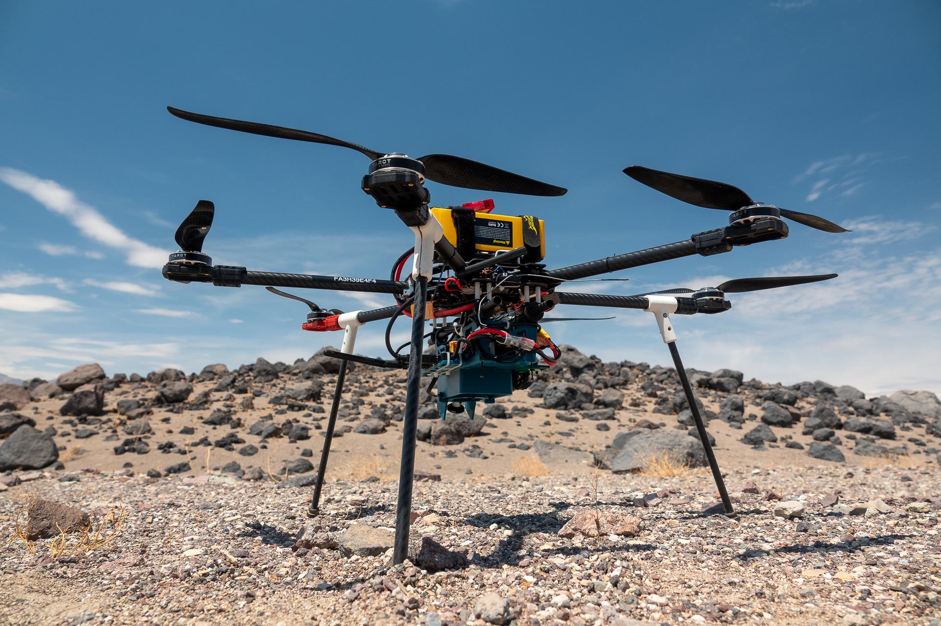
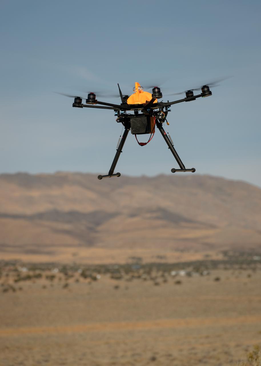
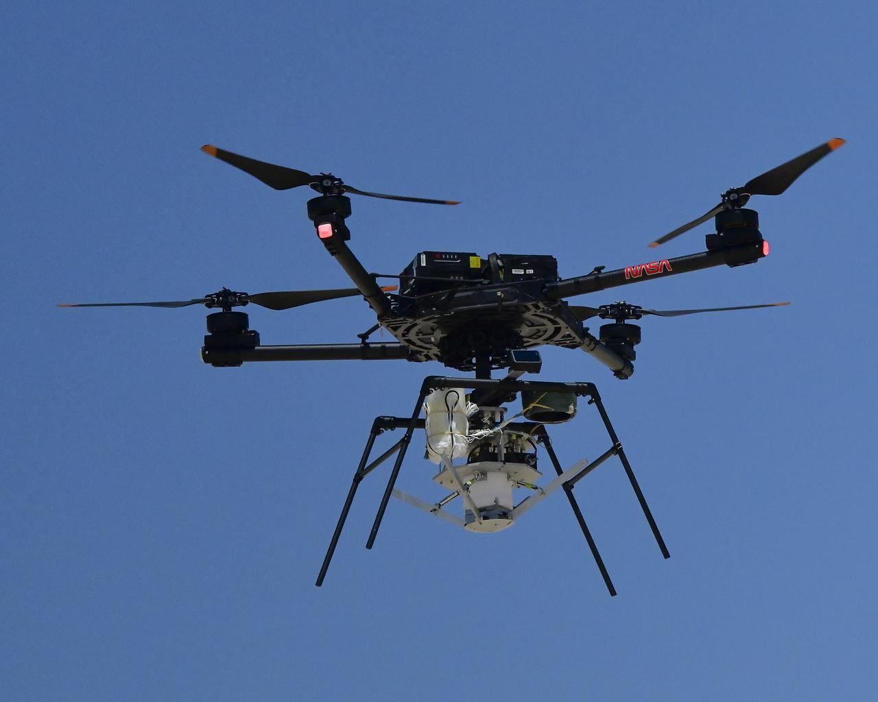
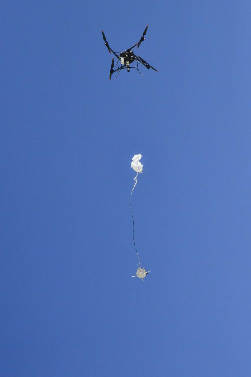
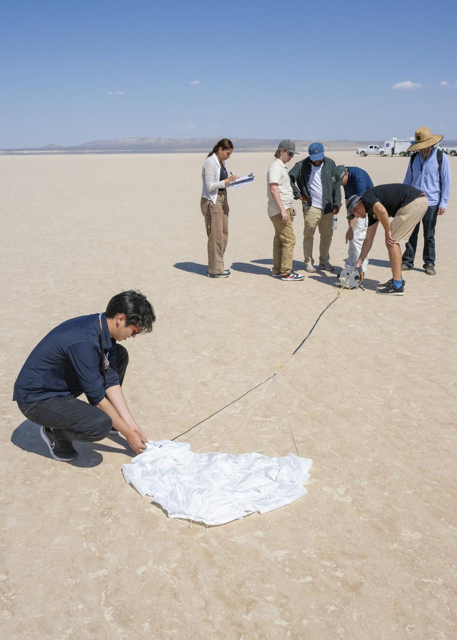
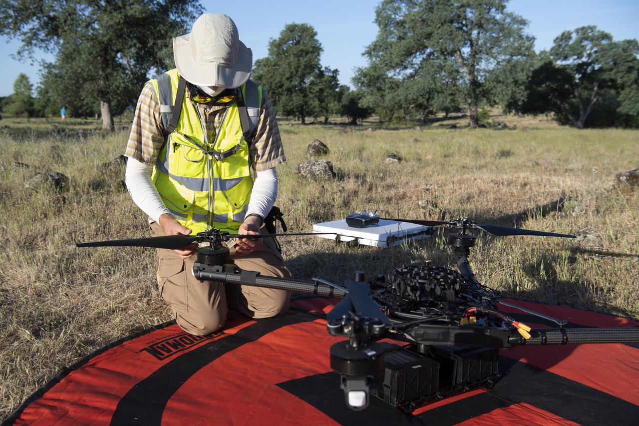
This is one of three research drones that NASA’s Jet Propulsion Laboratory in Southern California used in September 2025 to test navigation software that could be used by future rotorcraft on Mars. The drone is sitting in front of a location within Death Valley National Park called Mars Hill, which is littered with rubbly volcanic rocks and has been used by NASA’s Mars researchers since the 1970s, during preparations for the Viking lander missions. The work was among 25 projects funded by NASA’s Mars Exploration Program this past year to push the limits of future technologies. Sand dunes confused the navigation algorithm of the Ingenuity Mars helicopter during several of its last flights, including its 72nd and final flight on the Red Planet in January 2024. The navigation software in development would help future rotorcraft to track the surface of especially bland, featureless terrain similar to the barren sand dunes seen in parts of Death Valley and to land safely in cluttered environments like Mars Hill.
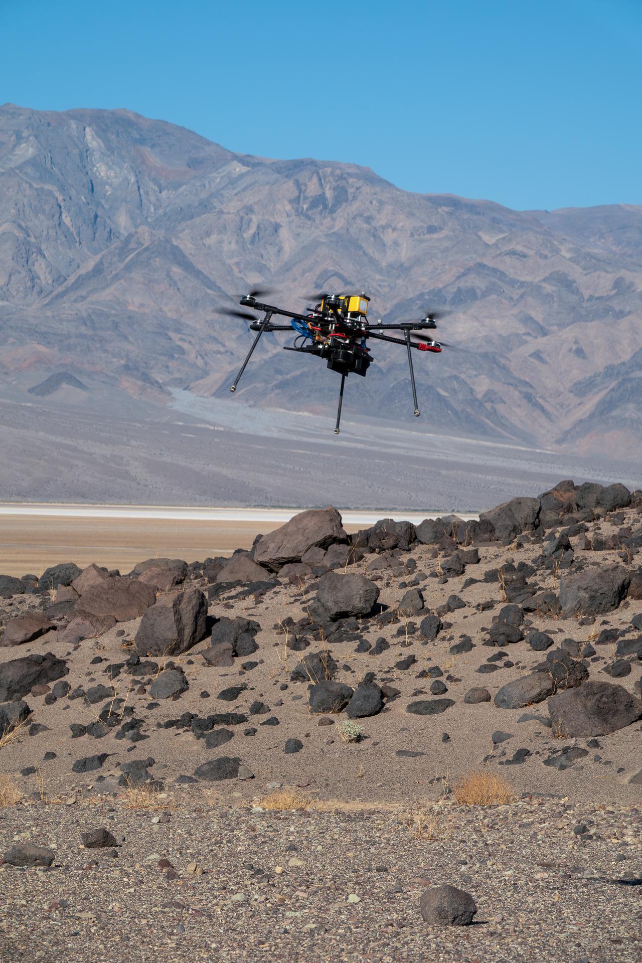
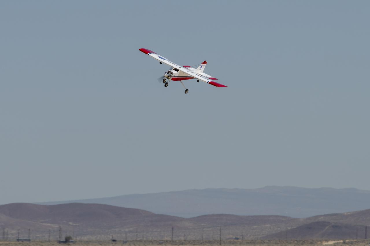
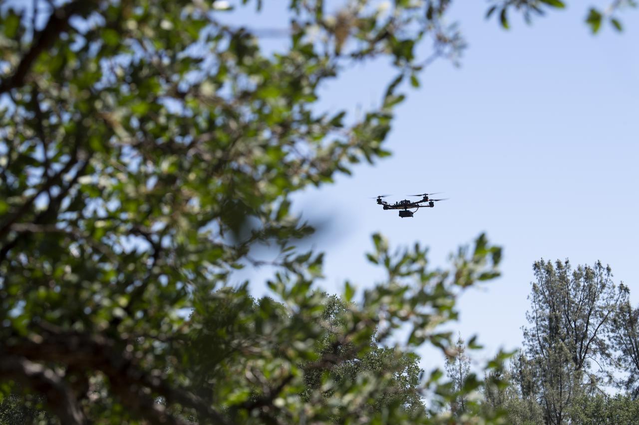
One of three drones used in recent tests by NASA’s Jet Propulsion Laboratory in Southern California flies over Mars Hill, a region of Death Valley National Park, in September 2025. The region’s rubbly, volcanic rocks have served as a Mars-like testing area and analog site for scientists since the 1970s, when NASA was preparing to land the twin Viking spacecraft on the Red Planet. The drone research — tests of navigation software for the Martian surface — was one of 25 projects funded by NASA’s Mars Exploration Program this past year to push the limits of future technologies. Sand dunes confused the navigation algorithm of the Ingenuity Mars helicopter during several of its last flights, including its 72nd and final flight on the Red Planet in January 2024. The navigation software in development would help future rotorcraft to track the surface of especially bland, featureless terrain similar to the barren sand dunes seen in parts of Death Valley and in the Mojave Desert and to land safely in cluttered environments like Mars Hill.
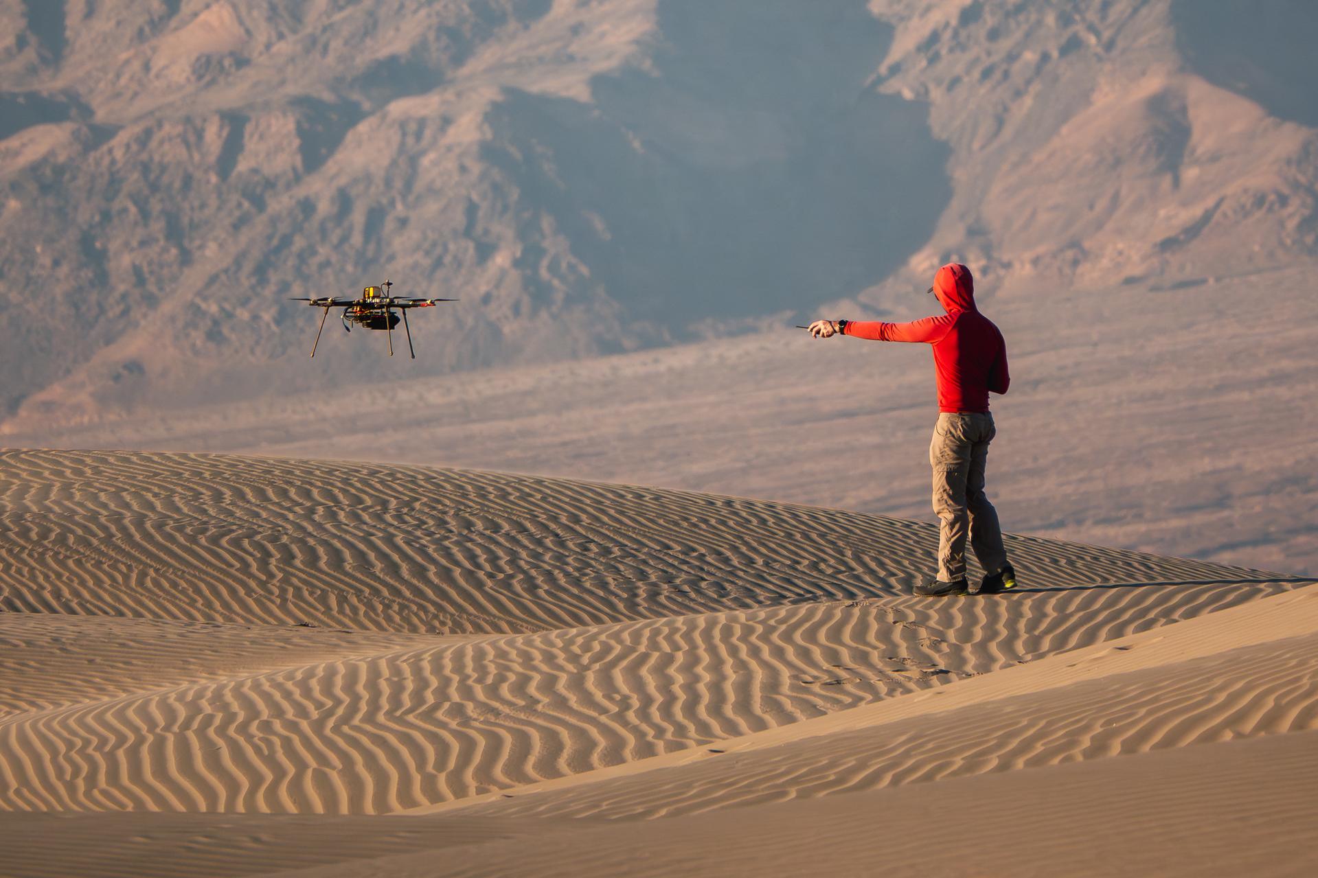
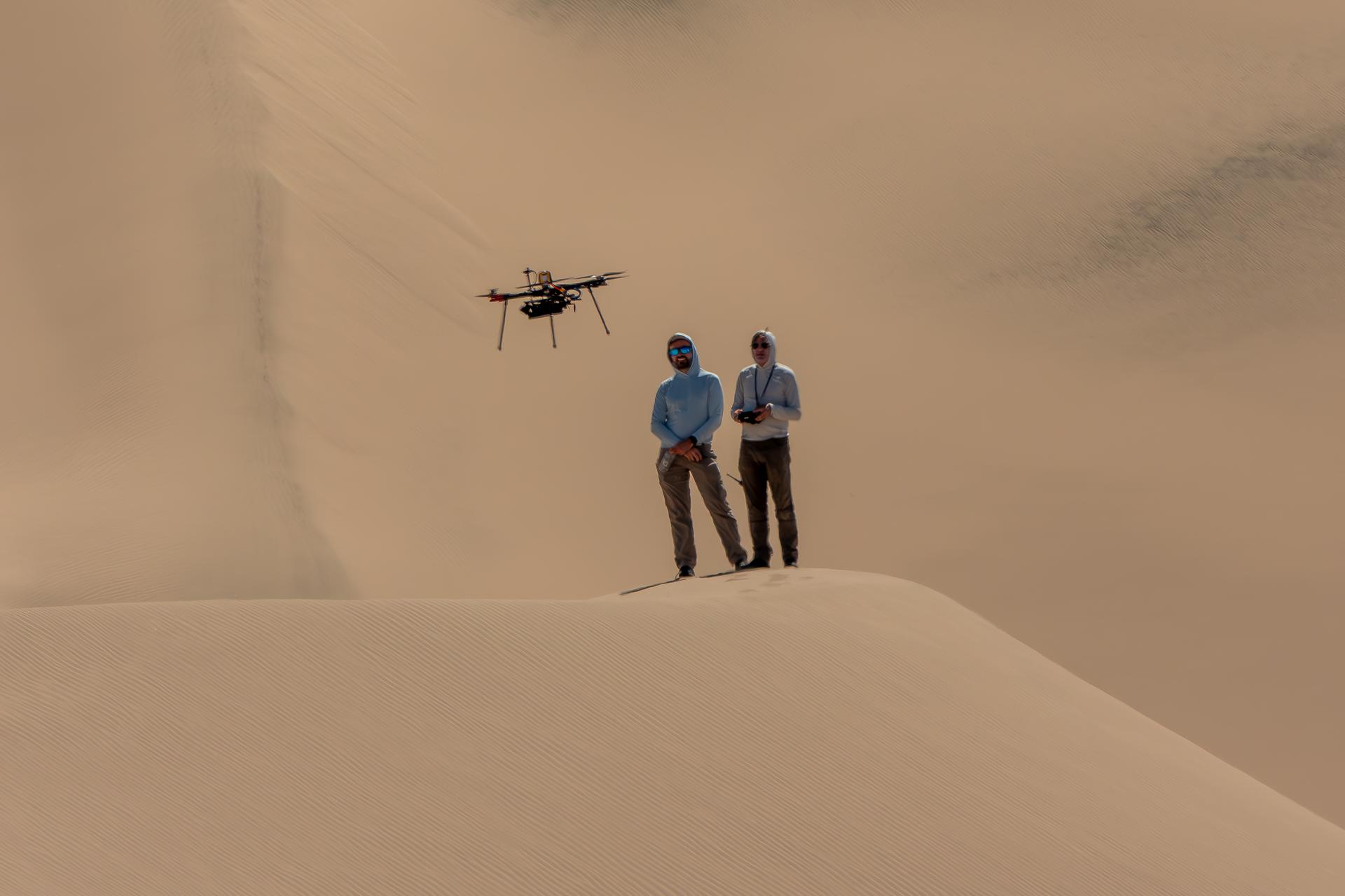
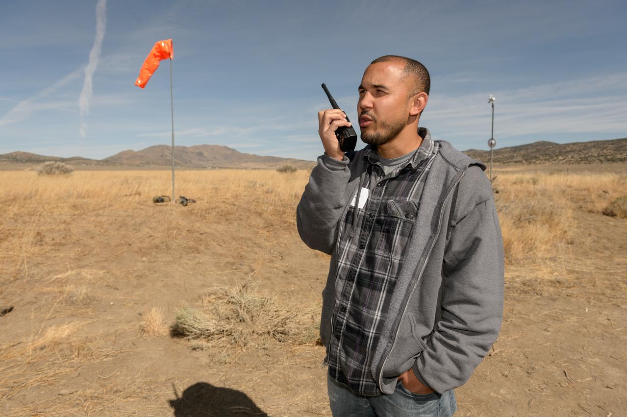
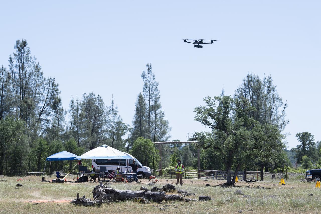
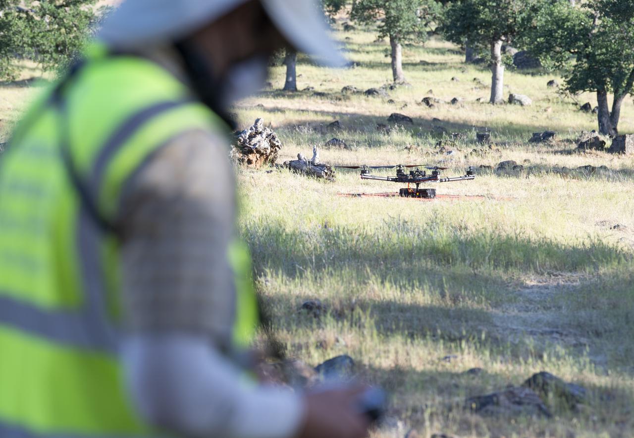
A researcher from NASA’s Jet Propulsion Laboratory in Southern California monitors a drone as it flies over sand dunes in September 2025. This image was captured in Death Valley National Park during a larger test campaign to develop navigation software that would guide future rotorcraft on Mars. The work was among 25 projects funded by NASA’s Mars Exploration Program this past year to push the limits of future technologies. Sand dunes confused the navigation algorithm of the Ingenuity Mars helicopter during several of its last flights, including its 72nd and final flight on the Red Planet in January 2024. The navigation software in development would help future rotorcraft track the surface of especially bland, featureless terrain similar to the barren sand dunes seen in parts of Death Valley. Tests also included flights over a region of the park called Mars Hill, which is littered with rubbly volcanic rocks and has been used by NASA’s Mars researchers since the 1970s, during preparations for the Viking lander missions.

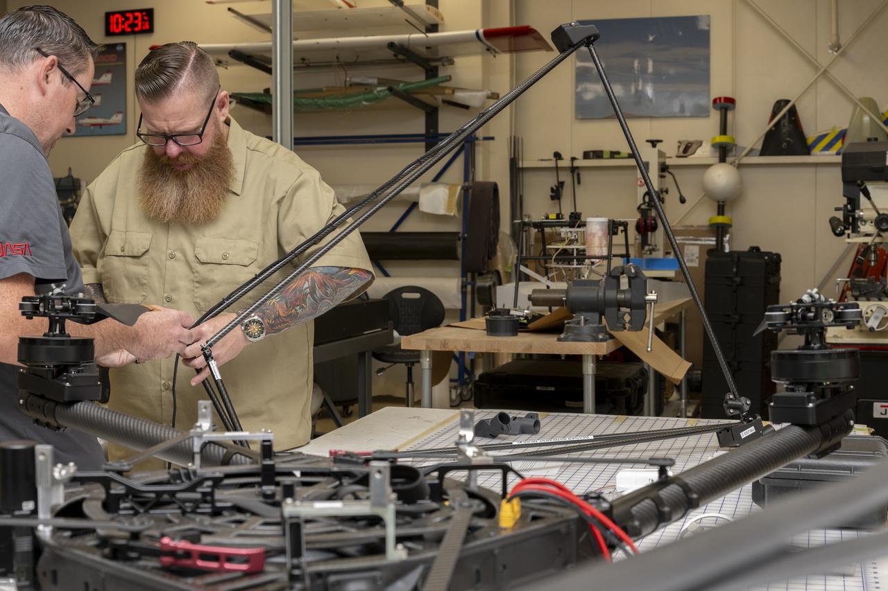
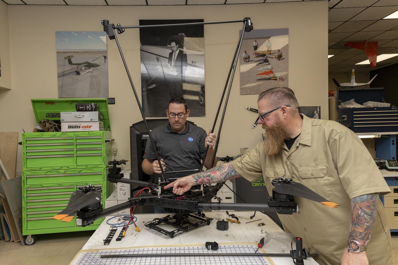
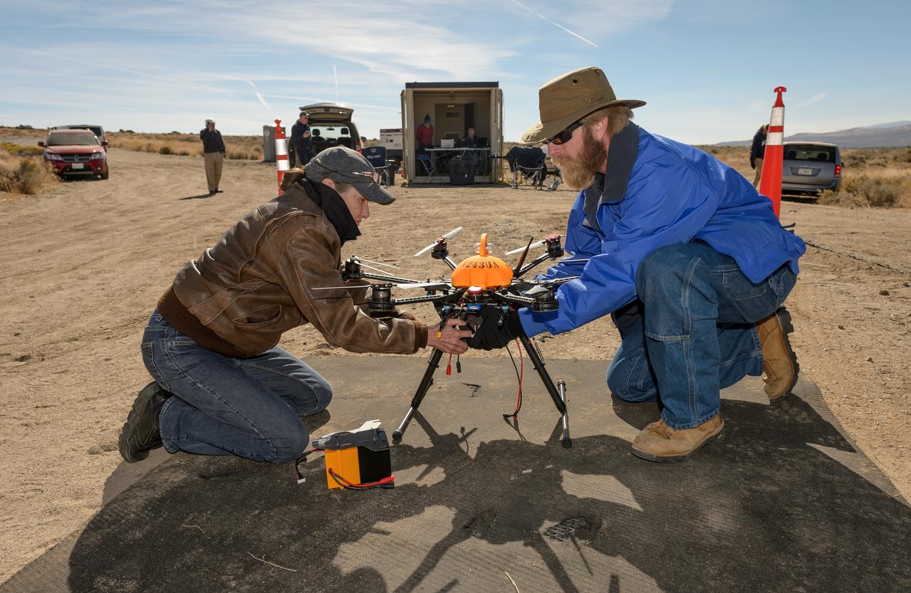
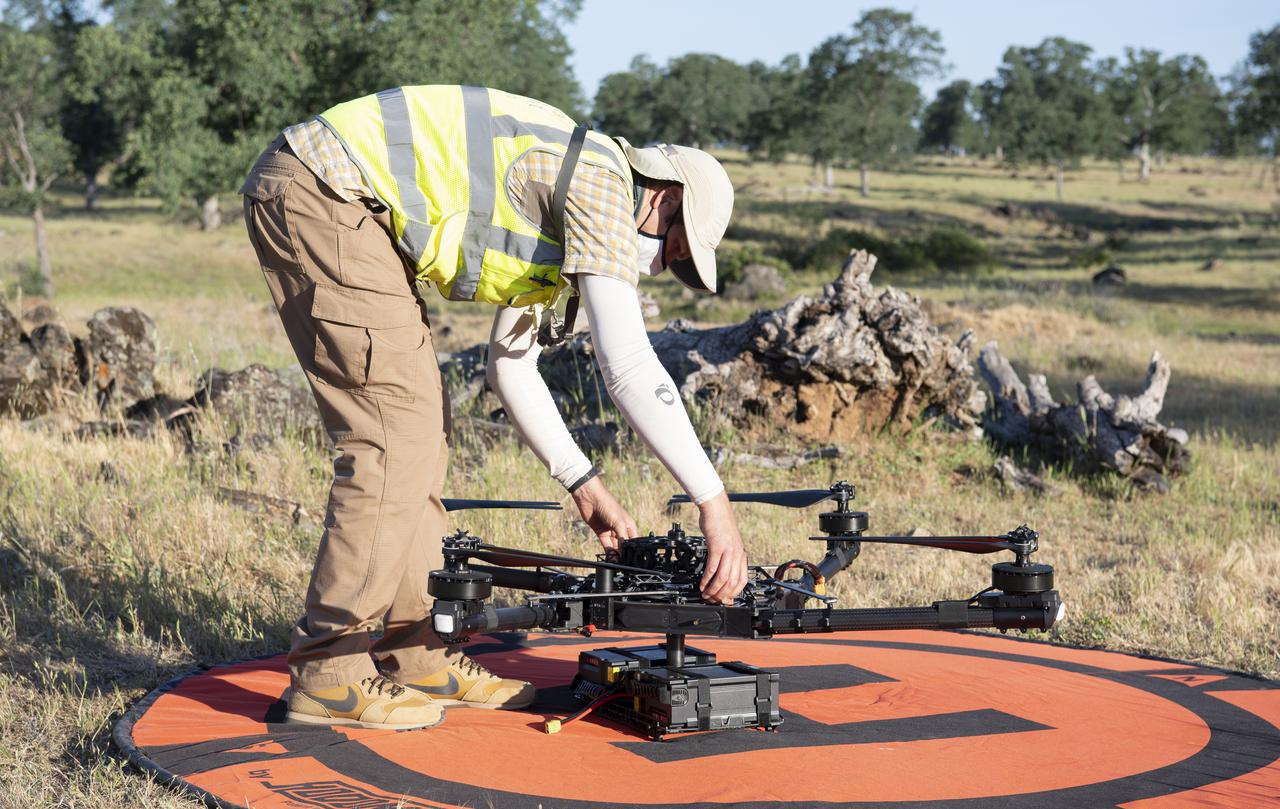
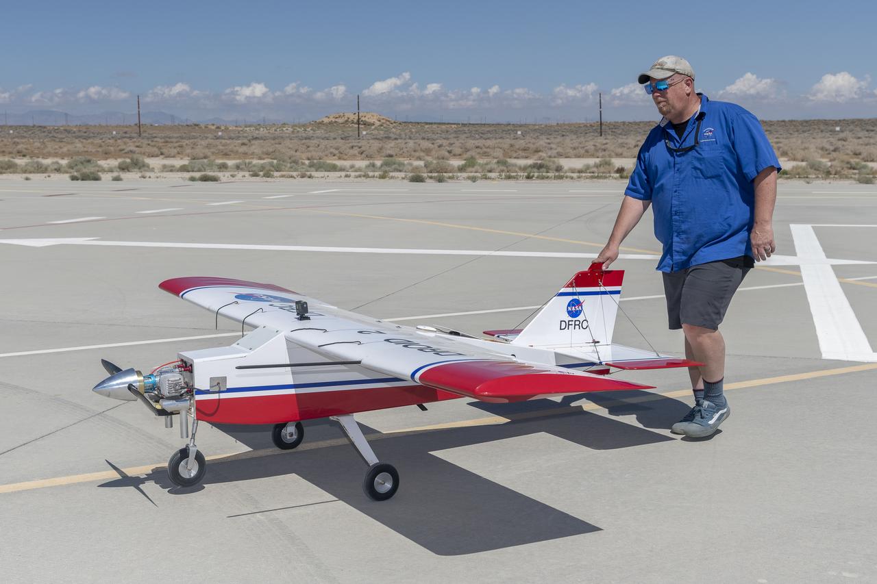
Justin Link, pilot for small uncrewed aircraft systems, installs weather instruments on NASA’s Alta X drone at the agency’s Armstrong Flight Research Center in Edwards, California. Members of the center’s Dale Reed Subscale Flight Research Laboratory used the Alta X to support the agency’s FireSense project in March 2025 for a prescribed burn in Geneva State Forest, which is about 100 miles south of Montgomery, Alabama.
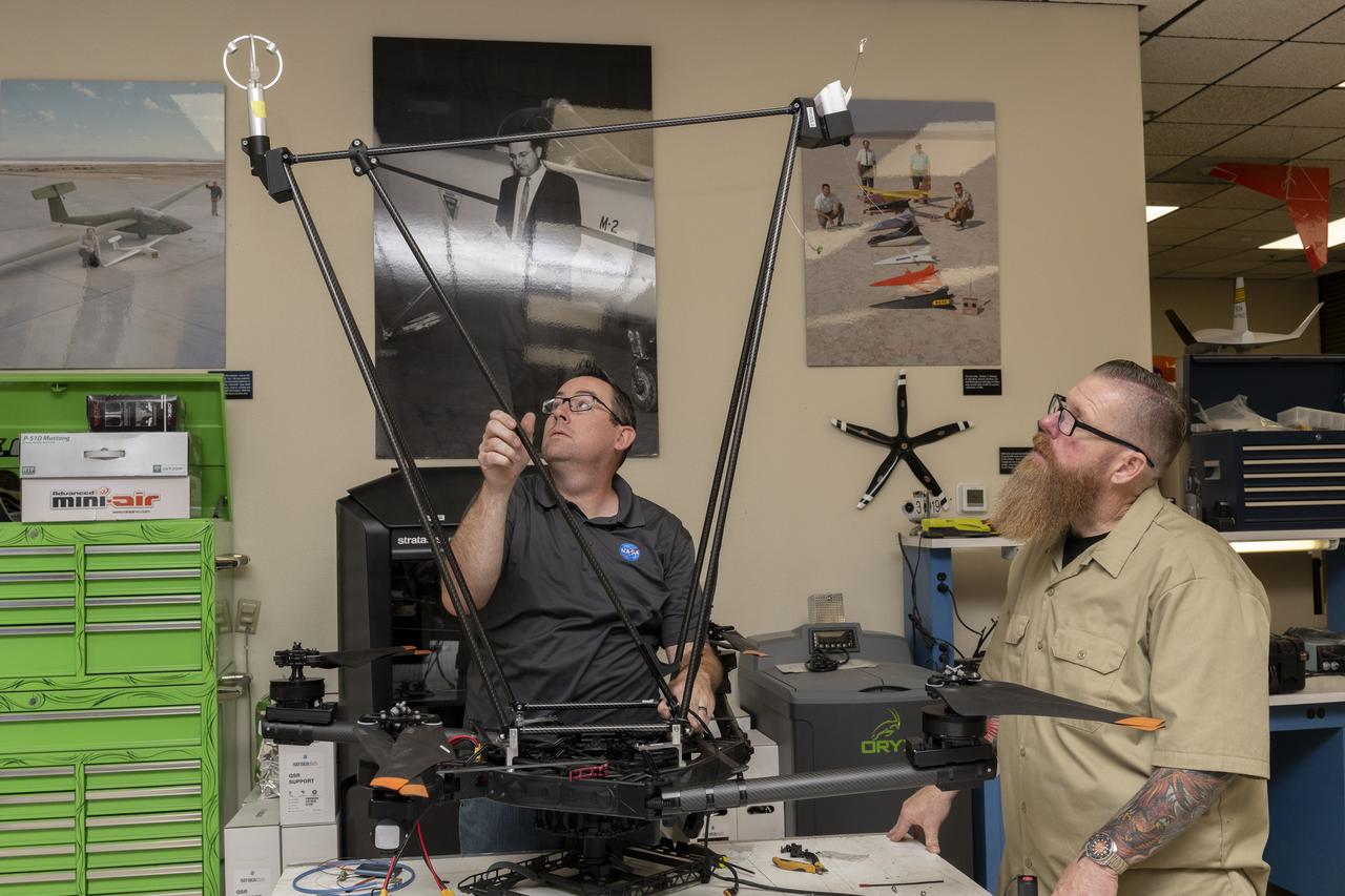
Justin Link, left, pilot for small uncrewed aircraft systems, and Justin Hall, chief pilot for small uncrewed aircraft systems, install weather instruments on NASA’s Alta X drone at the agency’s Armstrong Flight Research Center in Edwards, California. Members of the center’s Dale Reed Subscale Flight Research Laboratory used the Alta X to support the agency’s FireSense project in March 2025 for a prescribed burn in Geneva State Forest, which is about 100 miles south of Montgomery, Alabama.
Justin Link, left, pilot for small uncrewed aircraft systems, and Justin Hall, chief pilot for small uncrewed aircraft systems, install weather instruments on NASA’s Alta X drone at the agency’s Armstrong Flight Research Center in Edwards, California. Members of the center’s NASA Armstrong Dale Reed Subscale Flight Research Laboratory used the Alta X to support the NASA’s FireSense project in March 2025 for a prescribed burn in Geneva State Forest, which is about 100 miles south of Montgomery, Alabama.
Justin Link, left, pilot for small uncrewed aircraft systems, and Justin Hall, chief pilot for small uncrewed aircraft systems, install weather instruments on NASA’s Alta X drone at the agency’s Armstrong Flight Research Center in Edwards, California. Members of the center’s NASA Armstrong Dale Reed Subscale Flight Research Laboratory used the Alta X to support the NASA’s FireSense project in March 2025 for a prescribed burn in Geneva State Forest, which is about 100 miles south of Montgomery, Alabama.
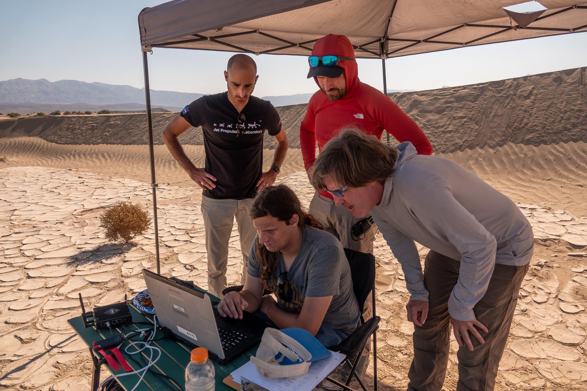
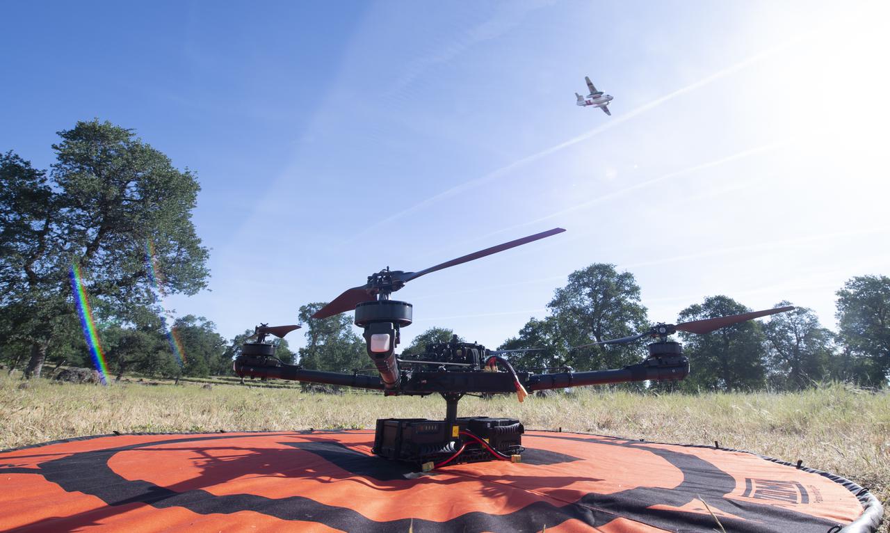
The work was among 25 projects funded by NASA’s Mars Exploration Program this past year to push the limits of future technologies. Sand dunes confused the navigation algorithm of the Ingenuity Mars helicopter during several of its last flights, including its 72nd and final flight on the Red Planet in January 2024. The navigation software in development would help future rotorcraft track the surface of especially bland, featureless terrain similar to the barren sand dunes seen in Death Valley’s Mesquite Flats Sand Dunes as well as in Dumont Dunes in the Mojave Desert, where testing was also conducted. Tests included flights over a region in Death Valley called Mars Hill, which is littered with rubbly volcanic rocks and has been used by NASA’s Mars researchers since the 1970s, during preparations for the Viking lander missions.
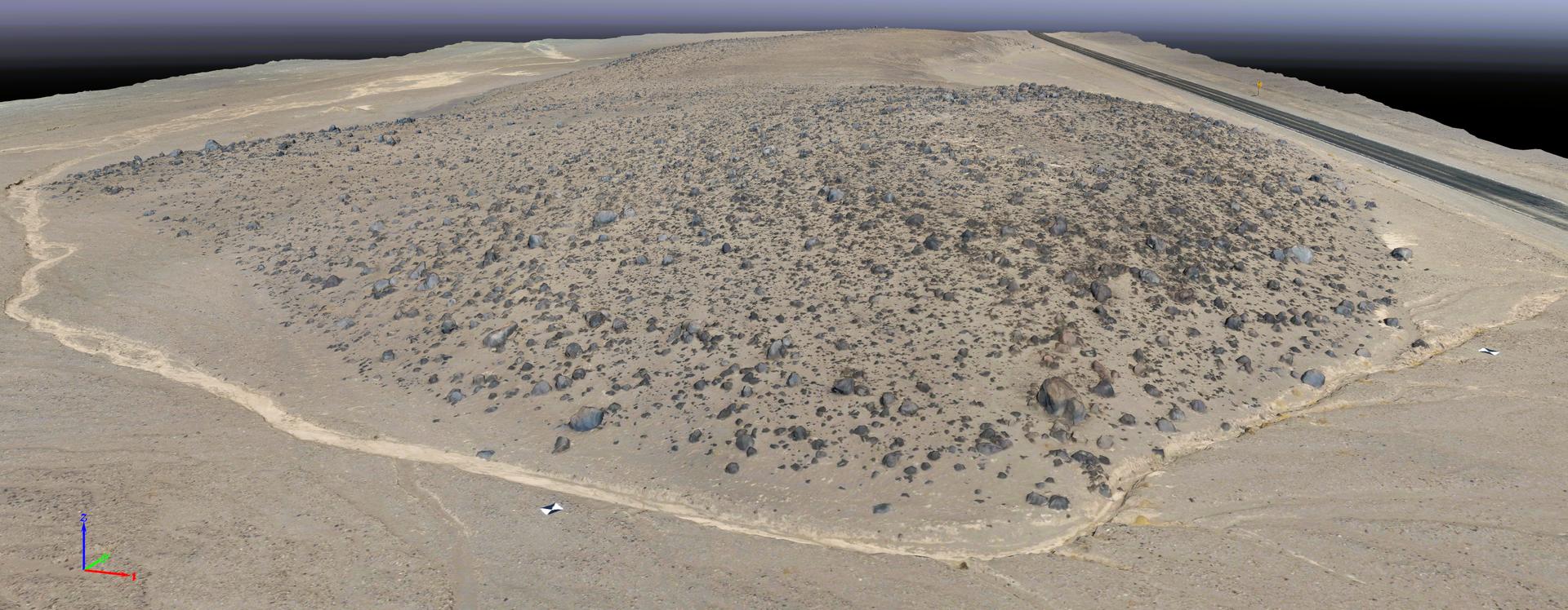
This rendering was created by research drones flying over Mars Hill, a region of Death Valley National Park that has been used by NASA’s Mars researchers since the 1970s, when the agency was preparing to land the twin Viking spacecraft. The hill’s rubbly, volcanic rock resembles the kind of inhospitable terrain that Mars rovers must navigate around and which posed a landing hazard for the Ingenuity Mars Helicopter. In September 2025, researchers from NASA’s Jet Propulsion Laboratory in Southern California flew research drones over Mars Hill as part of a test campaign to develop navigation software for future Mars rotorcraft. Being able to precisely land between rocks like those seen here is a critical capability to access similar Martian terrain in the future.
The work was among 25 projects funded by NASA’s Mars Exploration Program this past year to push the limits of future technologies. Sand dunes confused the navigation algorithm of the Ingenuity Mars helicopter during several of its last flights, including its 72nd and final flight on the Red Planet in January 2024. The navigation software in development would help future rotorcraft track the surface of especially bland, featureless terrain similar to the barren Dumont Dunes. Tests also included flights over a region in Death Valley called Mars Hill, which is littered with rubbly volcanic rocks and has been used by NASA’s Mars researchers since the 1970s, during preparations for the Viking lander missions.
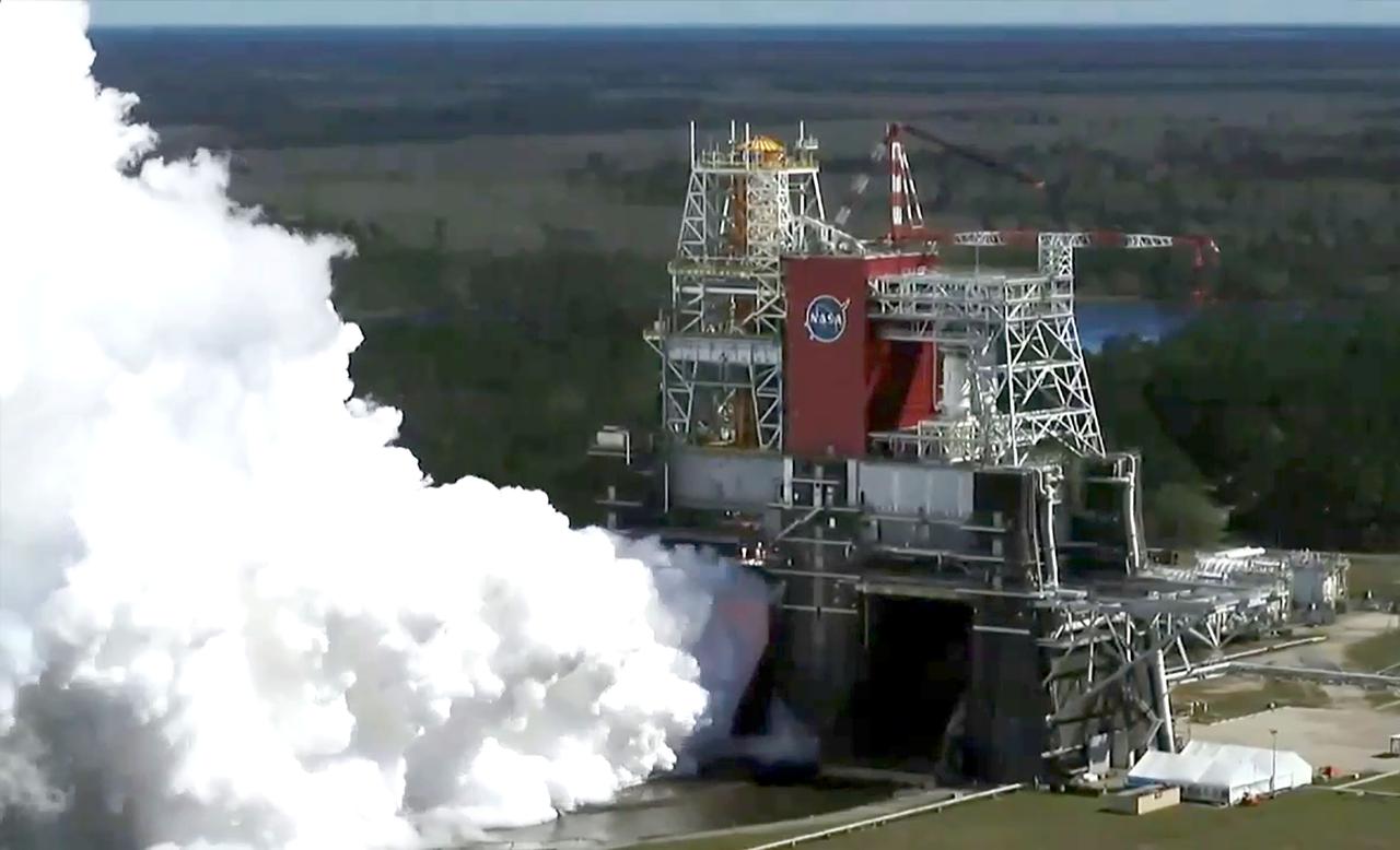
A drone camera offers a bird’s-eye view as NASA conducts a hot fire test March 18, 2021, of the core stage for the agency’s Space Launch System rocket on the B-2 Test Stand at Stennis Space Center near Bay St. Louis, Mississippi. The hot fire test of the stage’s four RS-25 engines generated a combined 1.6 million pounds of thrust, just as will occur during an actual launch. The hot fire is the final test of the Green Run test series, which represents a comprehensive assessment of the core stage and its integrated systems prior to its launch on the Artemis I mission to the Moon.
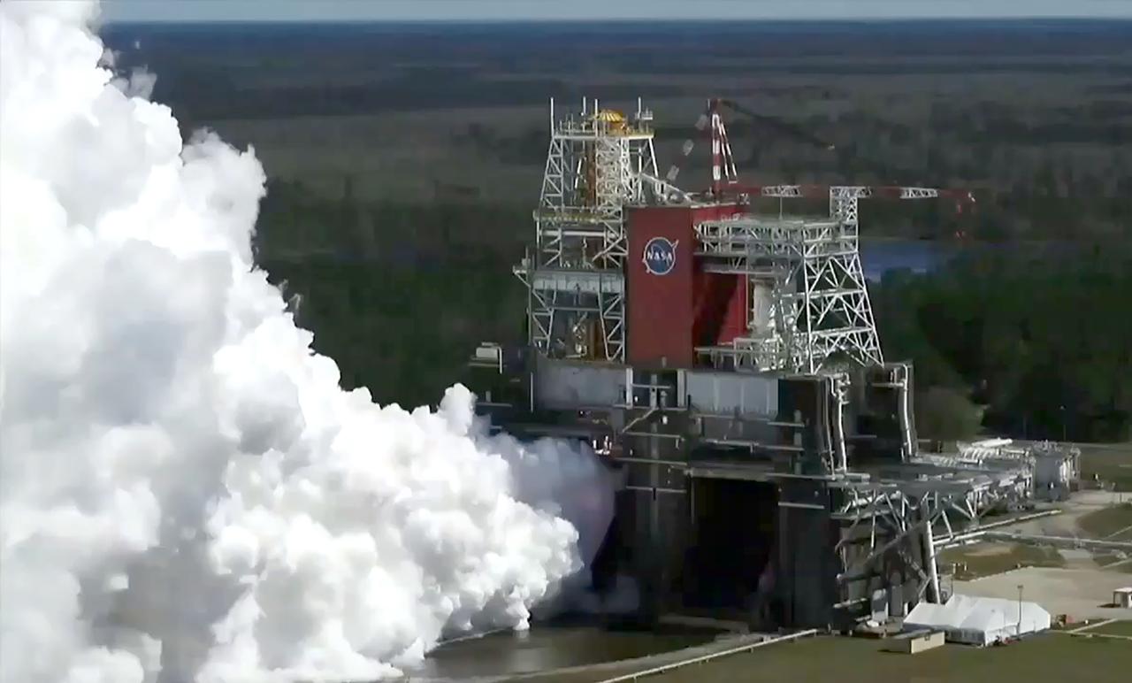
A drone camera offers a bird’s-eye view as NASA conducts a hot fire test March 18, 2021, of the core stage for the agency’s Space Launch System rocket on the B-2 Test Stand at Stennis Space Center near Bay St. Louis, Mississippi. The hot fire test of the stage’s four RS-25 engines generated a combined 1.6 million pounds of thrust, just as will occur during an actual launch. The hot fire is the final test of the Green Run test series, which represents a comprehensive assessment of the core stage and its integrated systems prior to its launch on the Artemis I mission to the Moon.
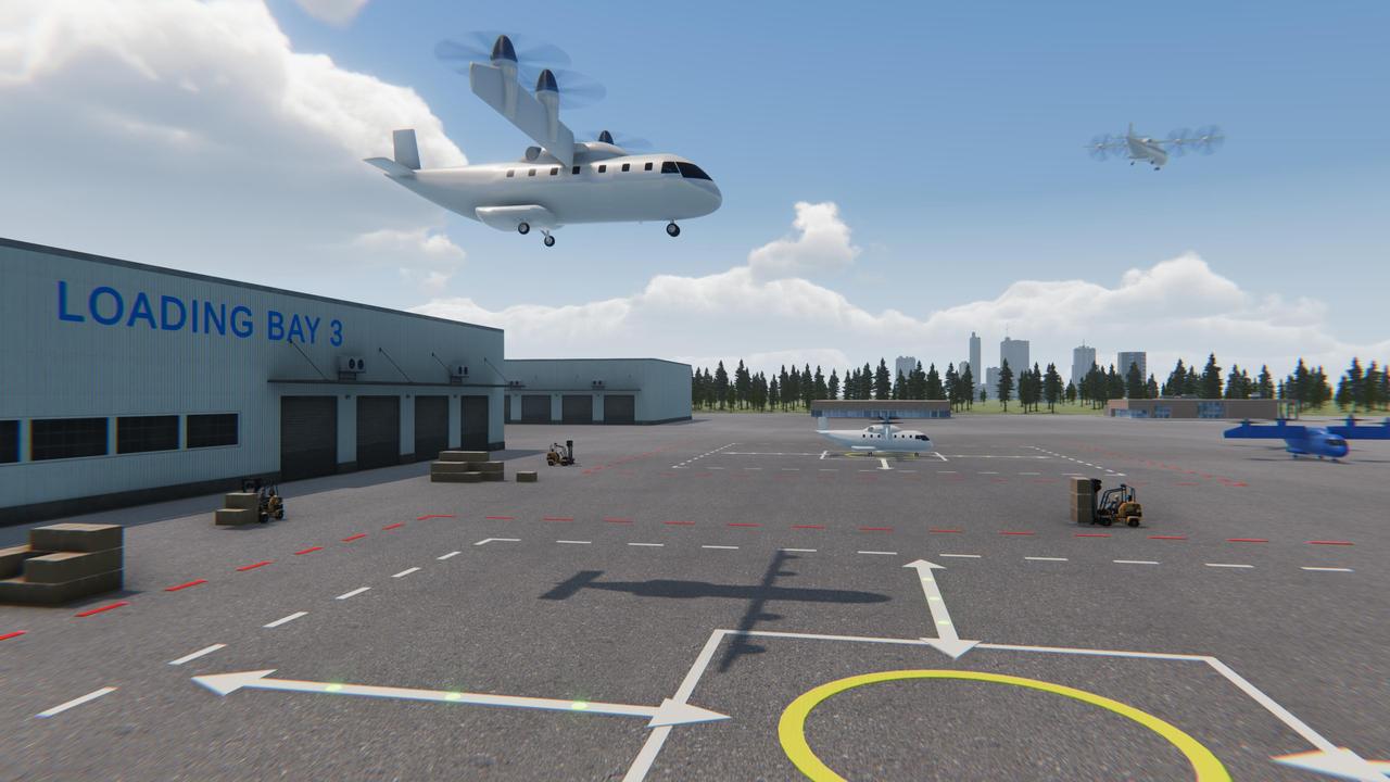
NASA is uniquely qualified to help revolutionize the Advanced Air Mobility cargo transportation industry by finding solutions for faster and cleaner modes of moving packages, using both large cargo delivery aircraft and small package delivery drones like seen in this concept image.

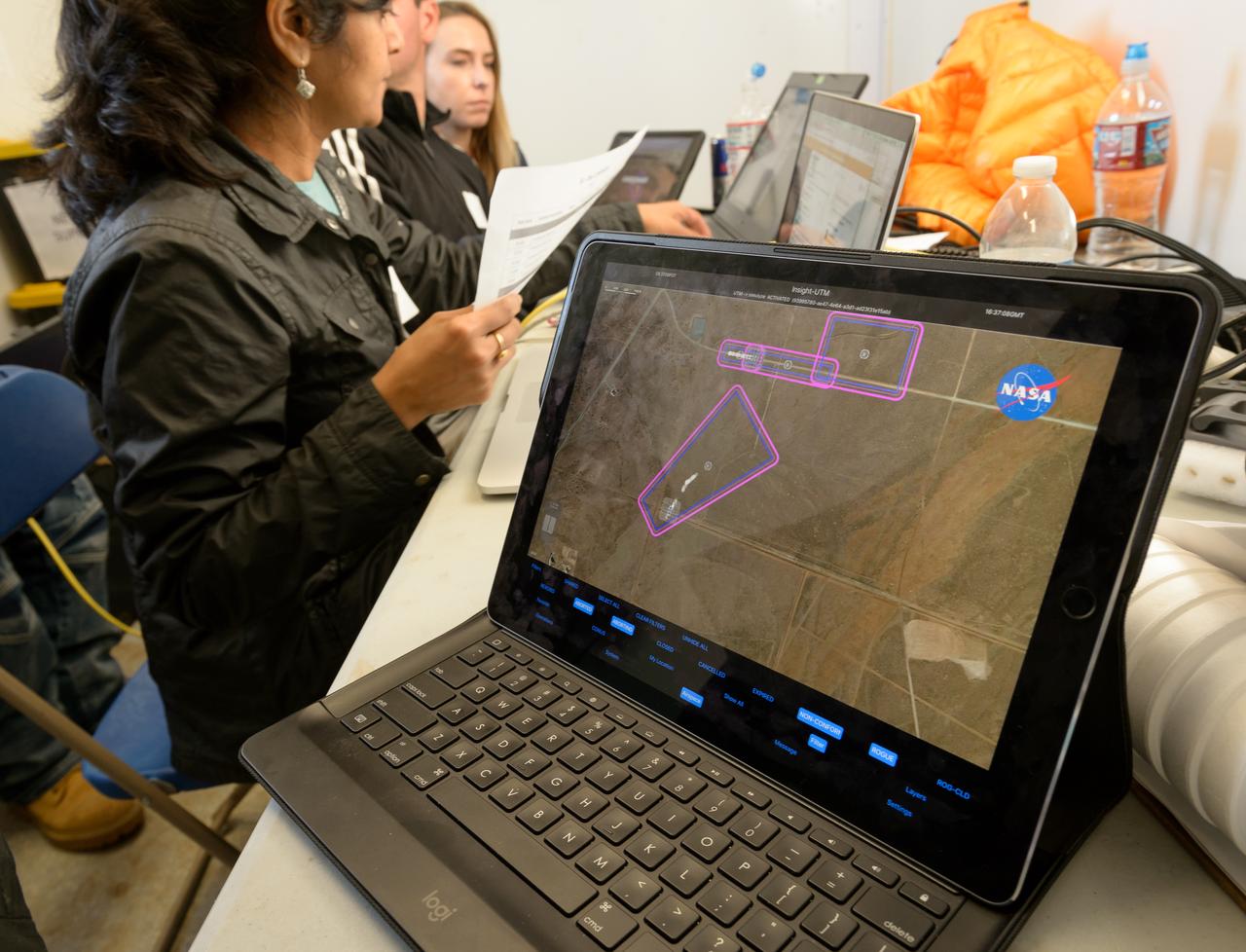
Test of Unmanned Aircraft Systems Traffic Management (UTM) technical capability Level 2 (TCL2) at Reno-Stead Airport, Nevada. During the test, five drones simultaneously crossed paths, separated by altitude. Two drones flew beyond visual line-of-sight and three flew within line-of-sight of their operators. Drone Co-habitation Services operates a Phantom 3 commercial multi-rotor unmanned aircraft, one of 11 vehicles in the UTM TCL2 demonstration that will fly beyond line of sight of the pilot in command in Nevada test.
Test of Unmanned Aircraft Systems Traffic Management (UTM) technical capability Level 2 (TCL2) at Reno-Stead Airport, Nevada. During the test, five drones simultaneously crossed paths, separated by altitude. Two drones flew beyond visual line-of-sight and three flew within line-of-sight of their operators.
Test of Unmanned Aircraft Systems Traffic Management (UTM) technical capability Level 2 (TCL2) at Reno-Stead Airport, Nevada. During the test, five drones simultaneously crossed paths, separated by altitude. Two drones flew beyond visual line-of-sight and three flew within line-of-sight of their operators.
Test of Unmanned Aircraft Systems Traffic Management (UTM) technical capability Level 2 (TCL2) at Reno-Stead Airport, Nevada. During the test, five drones simultaneously crossed paths, separated by altitude. Two drones flew beyond visual line-of-sight and three flew within line-of-sight of their operators.
Test of Unmanned Aircraft Systems Traffic Management (UTM) technical capability Level 2 (TCL2) at Reno-Stead Airport, Nevada. During the test, five drones simultaneously crossed paths, separated by altitude. Two drones flew beyond visual line-of-sight and three flew within line-of-sight of their operators.

Test of Unmanned Aircraft Systems Traffic Management (UTM) technical capability Level 2 (TCL2) at Reno-Stead Airport, Nevada. During the test, five drones simultaneously crossed paths, separated by altitude. Two drones flew beyond visual line-of-sight and three flew within line-of-sight of their operators.

Test of Unmanned Aircraft Systems Traffic Management (UTM) technical capability Level 2 (TCL2) at Reno-Stead Airport, Nevada. During the test, five drones simultaneously crossed paths, separated by altitude. Two drones flew beyond visual line-of-sight and three flew within line-of-sight of their operators.
Test of Unmanned Aircraft Systems Traffic Management (UTM) technical capability Level 2 (TCL2) at Reno-Stead Airport, Nevada. During the test, five drones simultaneously crossed paths, separated by altitude. Two drones flew beyond visual line-of-sight and three flew within line-of-sight of their operators.
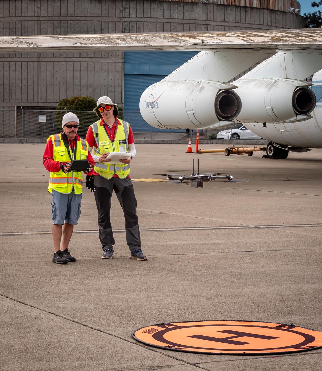
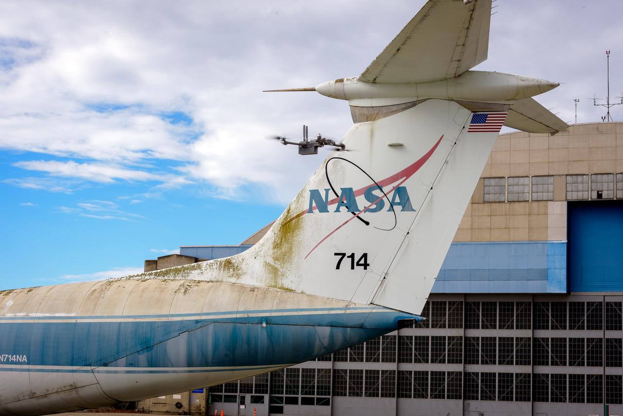
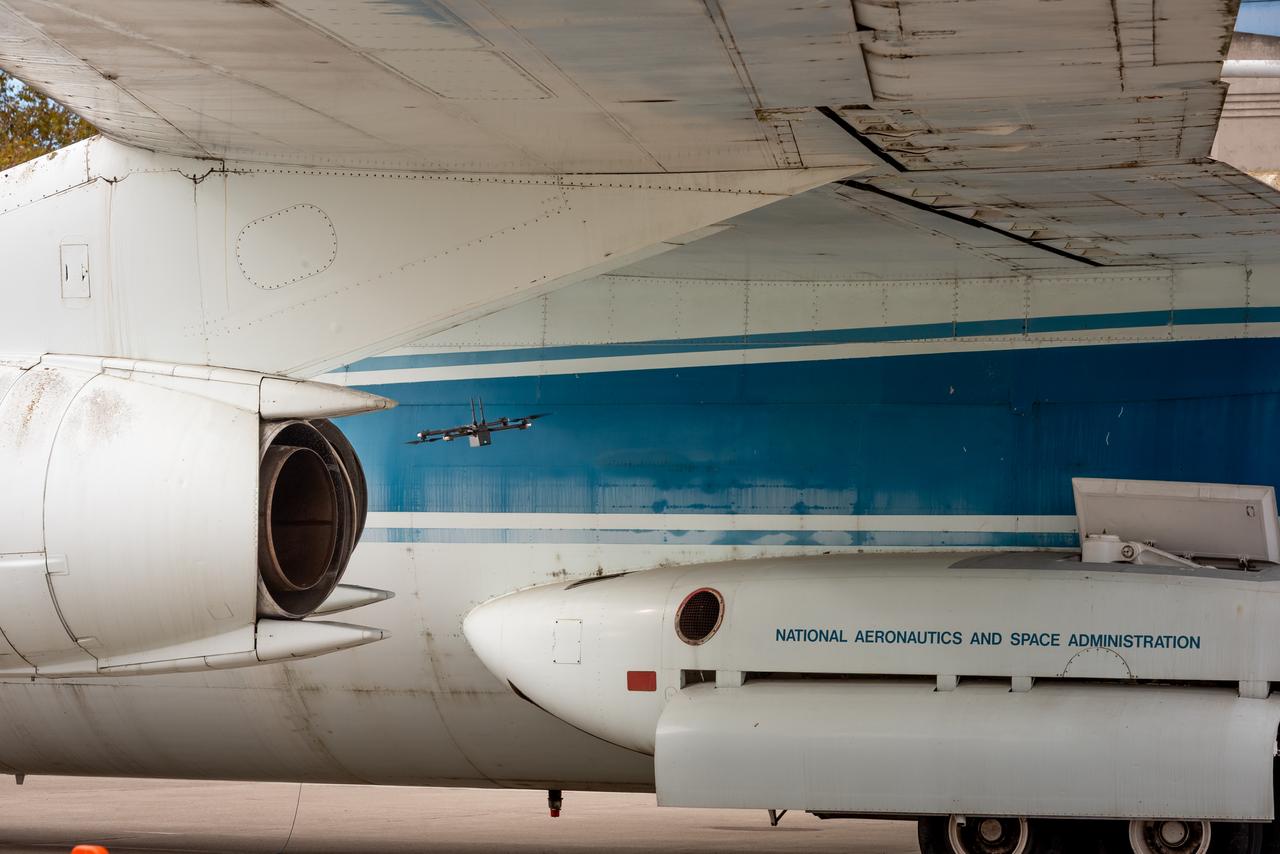
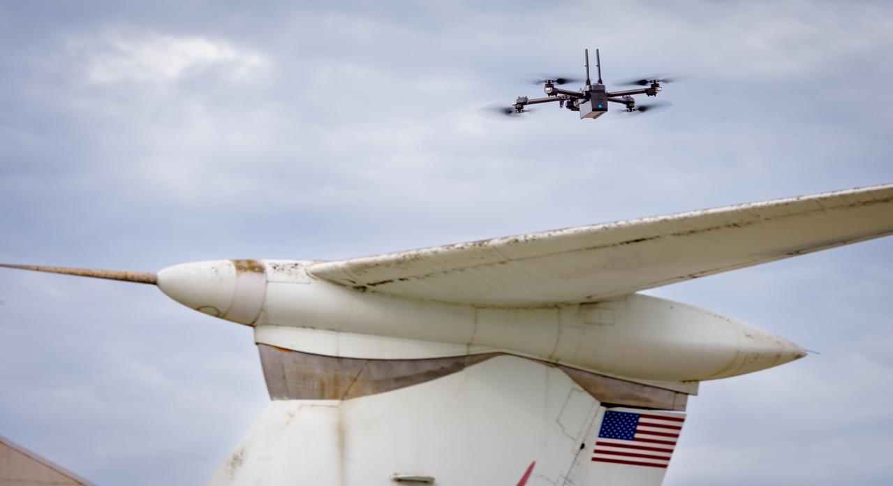
Richard Kolyer, left, with Jonas Jonsson guide the drone to land behind the modified C-141 Kuiper Airborne Observatory, (KAO) (NASA-714), on the N211 apron.
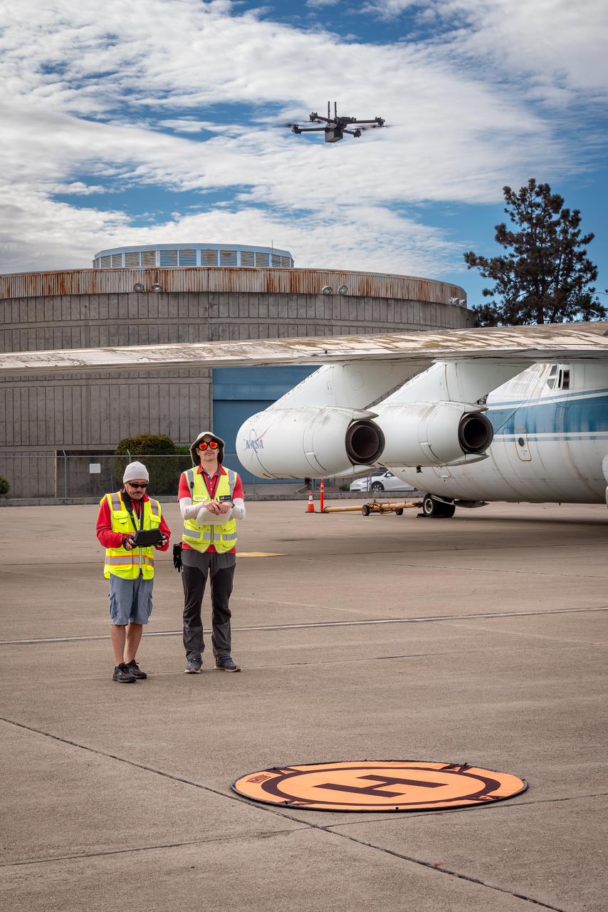
Richard Kolyer, left, with Jonas Jonsson guide the drone to land behind the modified C-141 Kuiper Airborne Observatory, (KAO) (NASA-714), on the N211 apron.
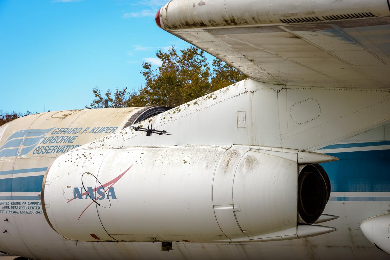
The drone follows an autonomously defined path around the modified C-141 Kuiper Airborne Observatory, (KAO) (NASA-714), on the N211 apron. The drone photographs the aircraft with a visible and infrared camera which are processed using a photogrammetry software package called Pix4D that converts them into a 3D model. Scanning the aircraft is the first phase of documenting the aircraft demolition as well as an opportunity to train pilots to operate the Pix4D software.

Test of Unmanned Aircraft Systems Traffic Management (UTM) technical capability Level 2 (TCL2) at Reno-Stead Airport, Nevada. During the test, five drones simultaneously crossed paths, separated by altitude. Two drones flew beyond visual line-of-sight and three flew within line-of-sight of their operators. Precision Hawk pilot readies Lancaster Mark 3 UAS for test flight.
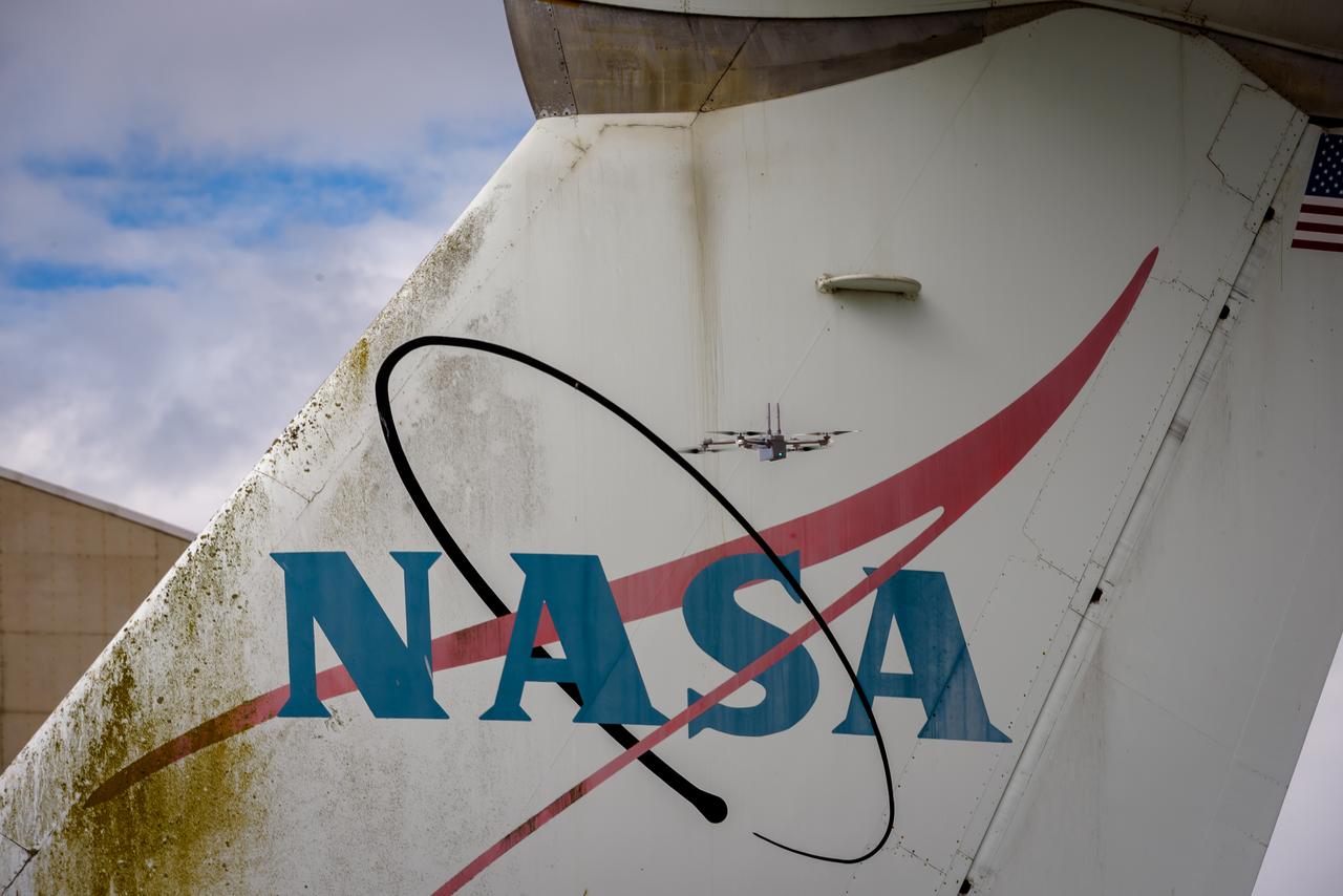
The drone follows an autonomously defined path around the modified C-141 Kuiper Airborne Observatory, (KAO) (NASA-714), on the N211 apron. The drone photographs the aircraft with a visible and infrared camera which are processed using a photogrammetry software package called Pix4D that converts them into a 3D model. Scanning the aircraft is the first phase of documenting the aircraft demolition as well as an opportunity to train pilots to operate the Pix4D software.
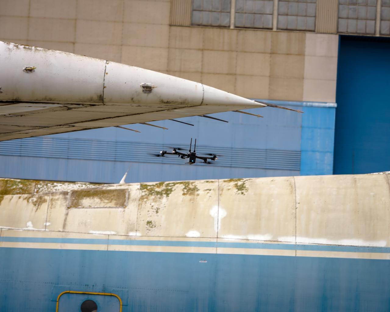
The drone follows an autonomously defined path around the modified C-141 Kuiper Airborne Observatory, (KAO) (NASA-714), on the N211 apron. The drone photographs the aircraft with a visible and infrared camera which are processed using a photogrammetry software package called Pix4D that converts them into a 3D model. Scanning the aircraft is the first phase of documenting the aircraft demolition as well as an opportunity to train pilots to operate the Pix4D software.

Test of Unmanned Aircraft Systems Traffic Management (UTM) technical capability Level 2 (TCL2) at Reno-Stead Airport, Nevada. During the test, five drones simultaneously crossed paths, separated by altitude. Two drones flew beyond visual line-of-sight and three flew within line-of-sight of their operators. Precision Hawk pilot launches UAS Lancaster Mark 3, one of 11 vehicles in the UTM TCL2 demonstration that will fly beyond line of sight of the pilot in command in Nevada test.
The drone follows an autonomously defined path around the modified C-141 Kuiper Airborne Observatory, (KAO) (NASA-714), on the N211 apron. The drone photographs the aircraft with a visible and infrared camera which are processed using a photogrammetry software package called Pix4D that converts them into a 3D model. Scanning the aircraft is the first phase of documenting the aircraft demolition as well as an opportunity to train pilots to operate the Pix4D software.
The drone follows an autonomously defined path around the modified C-141 Kuiper Airborne Observatory, (KAO) (NASA-714), on the N211 apron. The drone photographs the aircraft with a visible and infrared camera which are processed using a photogrammetry software package called Pix4D that converts them into a 3D model. Scanning the aircraft is the first phase of documenting the aircraft demolition as well as an opportunity to train pilots to operate the Pix4D software.
The drone follows an autonomously defined path around the modified C-141 Kuiper Airborne Observatory, (KAO) (NASA-714), on the N211 apron. The drone photographs the aircraft with a visible and infrared camera which are processed using a photogrammetry software package called Pix4D that converts them into a 3D model. Scanning the aircraft is the first phase of documenting the aircraft demolition as well as an opportunity to train pilots to operate the Pix4D software.
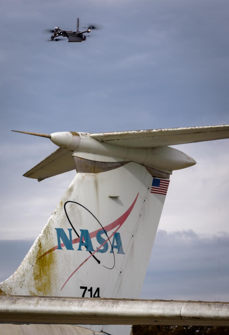
The drone follows an autonomously defined path around the modified C-141 Kuiper Airborne Observatory, (KAO) (NASA-714), on the N211 apron. The drone photographs the aircraft with a visible and infrared camera which are processed using a photogrammetry software package called Pix4D that converts them into a 3D model. Scanning the aircraft is the first phase of documenting the aircraft demolition as well as an opportunity to train pilots to operate the Pix4D software.
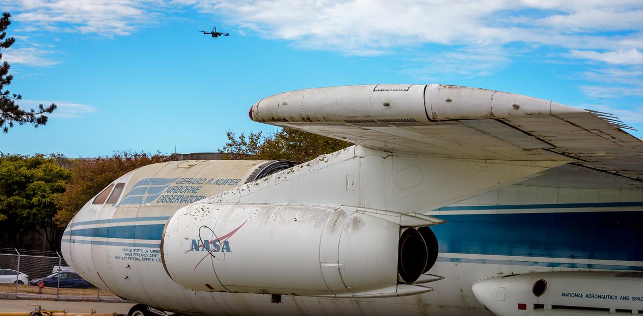
The drone follows an autonomously defined path around the modified C-141 Kuiper Airborne Observatory, (KAO) (NASA-714), on the N211 apron. The drone photographs the aircraft with a visible and infrared camera which are processed using a photogrammetry software package called Pix4D that converts them into a 3D model. Scanning the aircraft is the first phase of documenting the aircraft demolition as well as an opportunity to train pilots to operate the Pix4D software.

Test of Unmanned Aircraft Systems Traffic Management (UTM) technical capability Level 2 (TCL2) at Reno-Stead Airport, Nevada. During the test, five drones simultaneously crossed paths, separated by altitude. Two drones flew beyond visual line-of-sight and three flew within line-of-sight of their operators. Engineers Priya Venkatesan and Joey Mercer review flight paths using the UAS traffic management research platform at flight operations mission control at NASA’s UTM TCL2 test.

Test of Unmanned Aircraft Systems Traffic Management (UTM) technical capability Level 2 (TCL2) at Reno-Stead Airport, Nevada. During the test, five drones simultaneously crossed paths, separated by altitude. Two drones flew beyond visual line-of-sight and three flew within line-of-sight of their operators. Engineer Joey Mercer reviews flight paths using the UAS traffic management research platform UTM coordinator app to verify and validate flight paths.
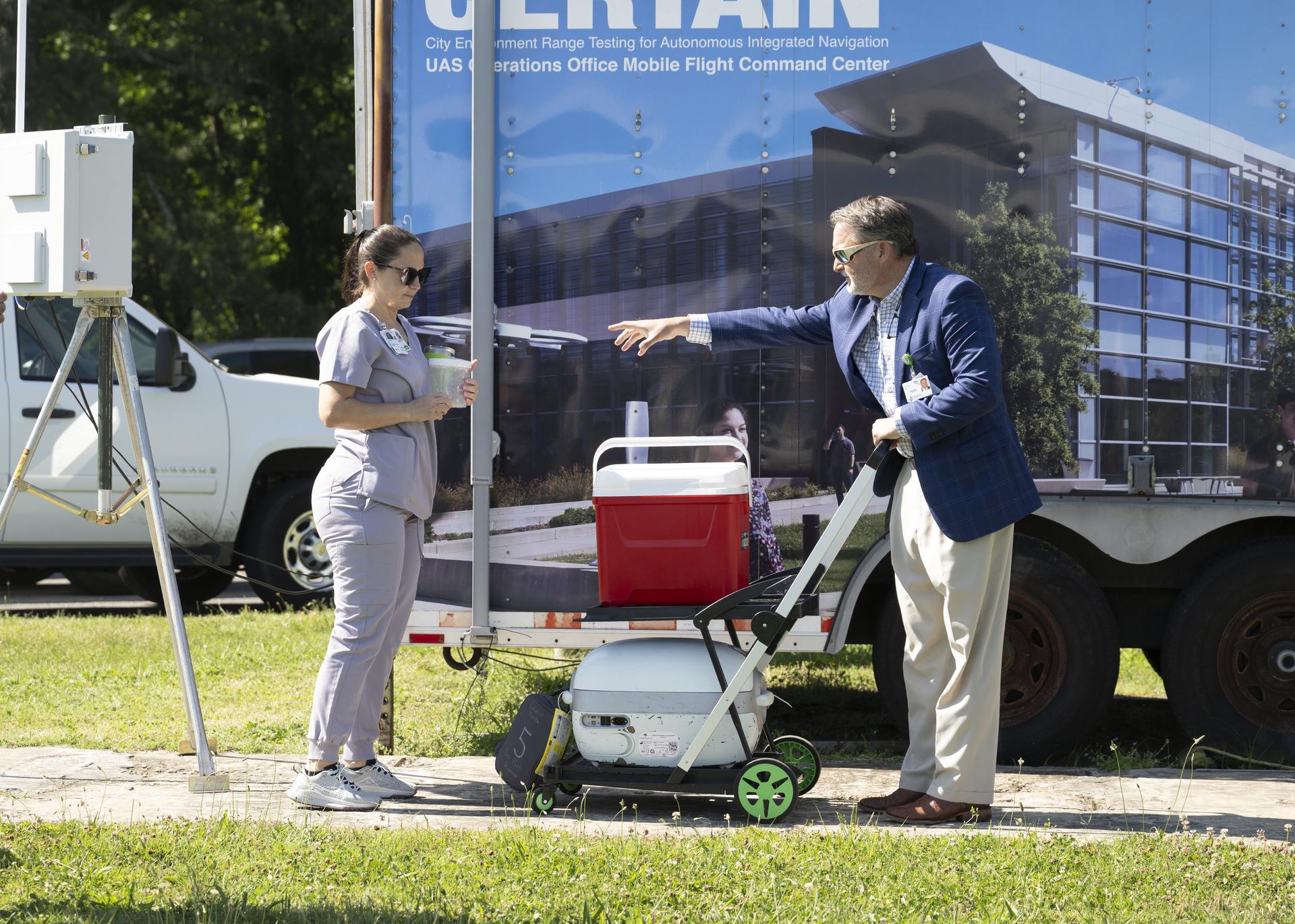
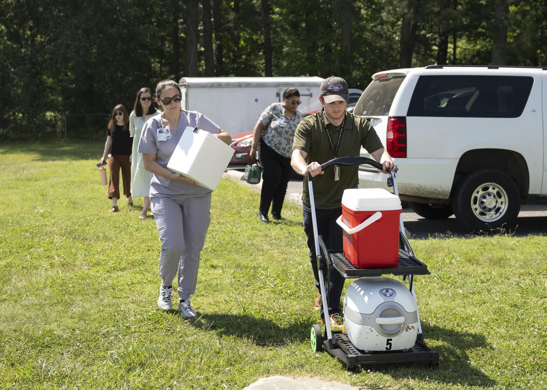
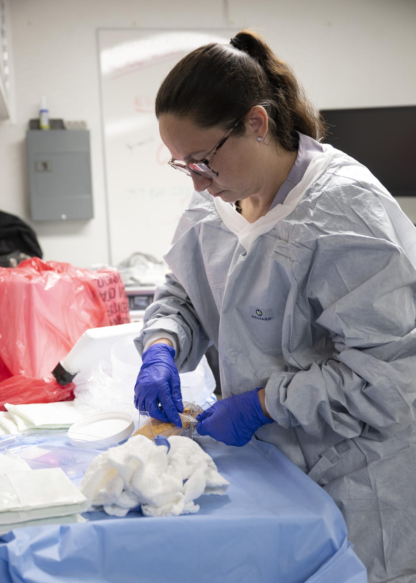
NASA Langley partnered with UNOS, a non-profit organization that manages the U.S. organ transplant system, to conduct the first-of-its-kind organ transport drone test with a human kidney on June 5, 2026 at Langley Research Center in Hampton, Va. Photo Credit NASA/Ryan Hill
NASA Langley partnered with UNOS, a non-profit organization that manages the U.S. organ transplant system, to conduct the first-of-its-kind organ transport drone test with a human kidney on June 5, 2026 at Langley Research Center in Hampton, Va. Photo Credit NASA/Mark Knopp

NASA Langley partnered with UNOS, a non-profit organization that manages the U.S. organ transplant system, to conduct the first-of-its-kind organ transport drone test with a human kidney on June 5, 2026 at Langley Research Center in Hampton, Va. Photo Credit NASA/Ryan Hill

NASA Langley partnered with UNOS, a non-profit organization that manages the U.S. organ transplant system, to conduct the first-of-its-kind organ transport drone test with a human kidney on June 5, 2026 at Langley Research Center in Hampton, Va. Photo Credit NASA/Mark Knopp
NASA Langley partnered with UNOS, a non-profit organization that manages the U.S. organ transplant system, to conduct the first-of-its-kind organ transport drone test with a human kidney on June 5, 2026 at Langley Research Center in Hampton, Va. Photo Credit NASA/Ryan Hill
NASA Langley partnered with UNOS, a non-profit organization that manages the U.S. organ transplant system, to conduct the first-of-its-kind organ transport drone test with a human kidney on June 5, 2026 at Langley Research Center in Hampton, Va.Photo Credit NASA/Ryan Hill
NASA Langley partnered with UNOS, a non-profit organization that manages the U.S. organ transplant system, to conduct the first-of-its-kind organ transport drone test with a human kidney on June 5, 2026 at Langley Research Center in Hampton, Va. Photo Credit NASA/Ryan Hill
Test of Unmanned Aircraft Systems Traffic Management (UTM) technical capability Level 2 (TCL2) at Reno-Stead Airport, Nevada. During the test, five drones simultaneously crossed paths, separated by altitude. Two drones flew beyond visual line-of-sight and three flew within line-of-sight of their operators. Karen Bollinger pilot and Nick Atkins of Alaska Center for Unmanned Aircraft Systems Integration program fly Ptarmigan quadcopter, one of 11 vehicles in the UTM TCL2 demonstration that will fly beyond line of sight of the pilot in command in Nevada test.

A drone show is seen during the Mars celebration Friday, May 31, 2019, in Mars, Pennsylvania. NASA is in the small town to celebrate Mars exploration and share the agency’s excitement about landing astronauts on the Moon in five years. The celebration includes a weekend of Science, Technology, Engineering, Arts and Mathematics (STEAM) activities. Photo Credit: (NASA/Bill Ingalls)

A drone show is seen during the Mars celebration Friday, May 31, 2019, in Mars, Pennsylvania. NASA is in the small town to celebrate Mars exploration and share the agency’s excitement about landing astronauts on the Moon in five years. The celebration includes a weekend of Science, Technology, Engineering, Arts and Mathematics (STEAM) activities. Photo Credit: (NASA/Bill Ingalls)
Vigilant Aerospace Systems CEO Kraettli Epperson, left, and NASA Armstrong Flight Research Center Director David McBride, sign the agreement for the company to commercialize a large drone communication system for the Federal Aviation Administration's aircraft tracking system called the Automatic Dependent Surveillance Broadcast. This communication system, which is to be mandated by the FAA for most aircraft in 2020, brings large, unmanned aircraft a step closer to flying in the National Airspace System.
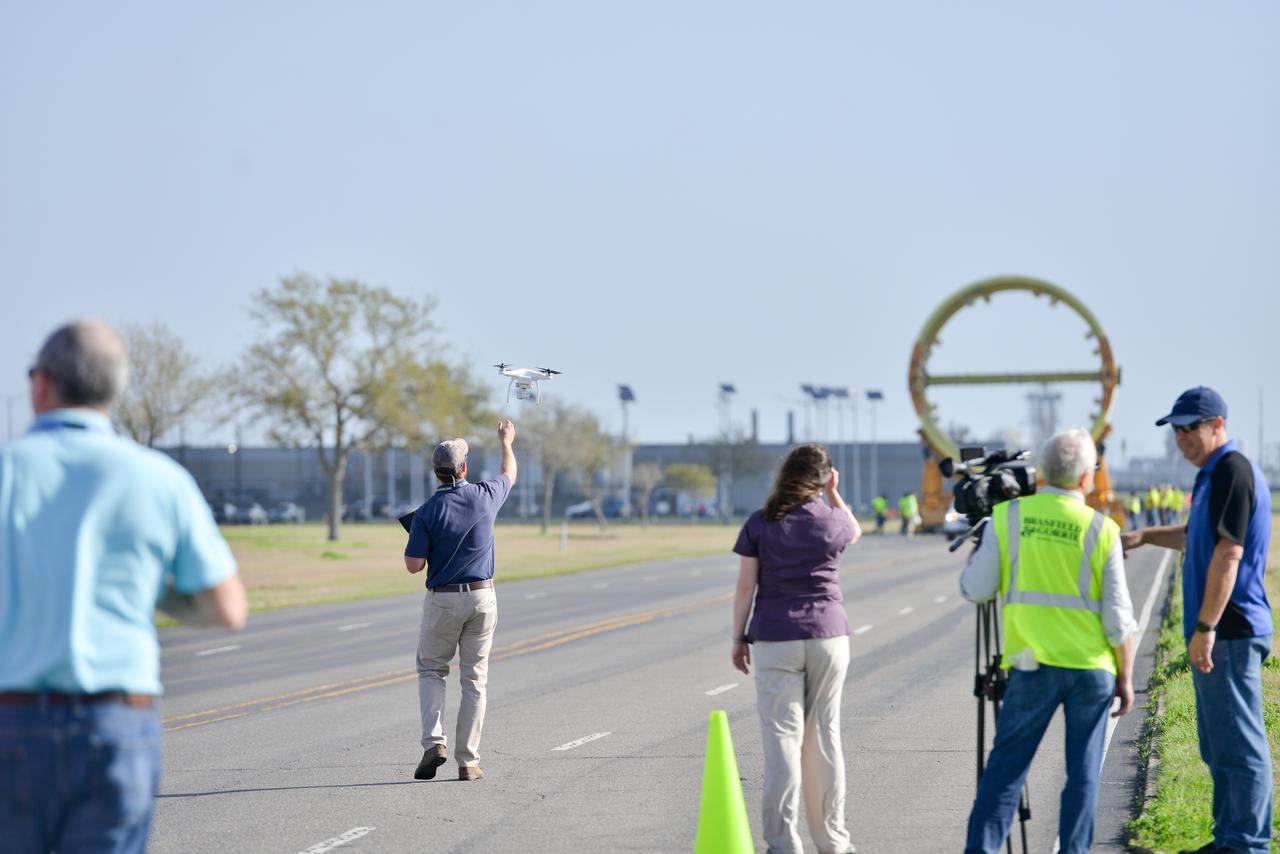
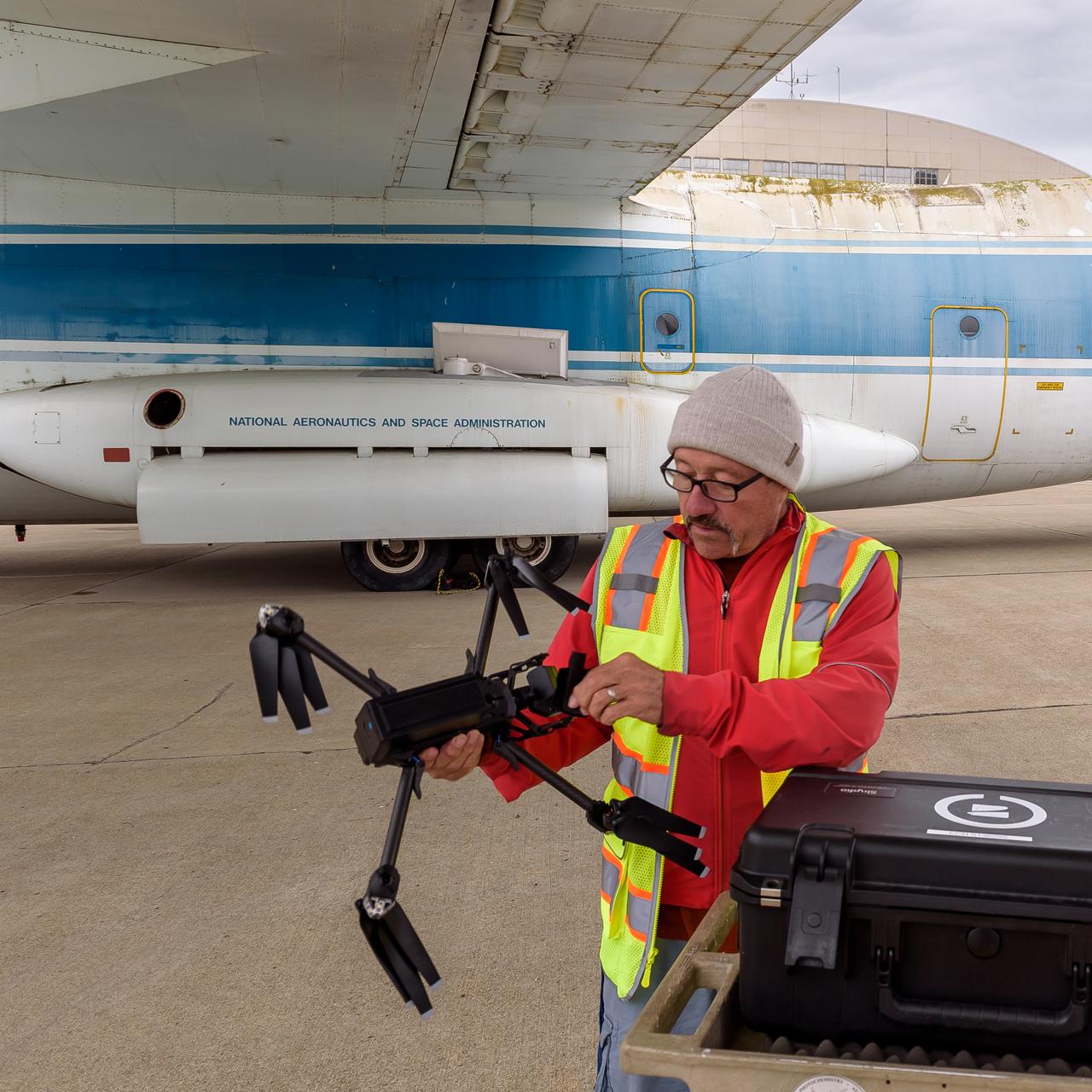
Derek Abramson, left, and Justin Link, right, attach an Alta X drone to the Enhancing Parachutes by Instrumenting the Canopy test experiment on June 4, 2025, at NASA’s Armstong Flight Research Center in Edwards, California. Abramson is NASA chief engineer at the center’s Dale Reed Subscale Flight Research Laboratory, where Link also works as a pilot for small uncrewed aircraft systems. NASA researchers are developing technology to make supersonic parachutes safer and more reliable for delivering science instruments and payloads to Mars.
A drone camera captures NASA’s mobile launcher 1 atop the agency’s crawler-transporter 2 moving from Launch Complex 39B to the Vehicle Assembly Building at NASA’s Kennedy Space Center in Florida on Thursday, Oct. 3, 2024. The mobile launcher has been at the launch pad since August 2023 undergoing upgrades and tests in preparation for NASA’s Artemis II mission. The mobile launcher will be used to assemble, process, and launch NASA’s SLS (Space Launch Systems) and Orion spacecraft to the Moon and beyond.
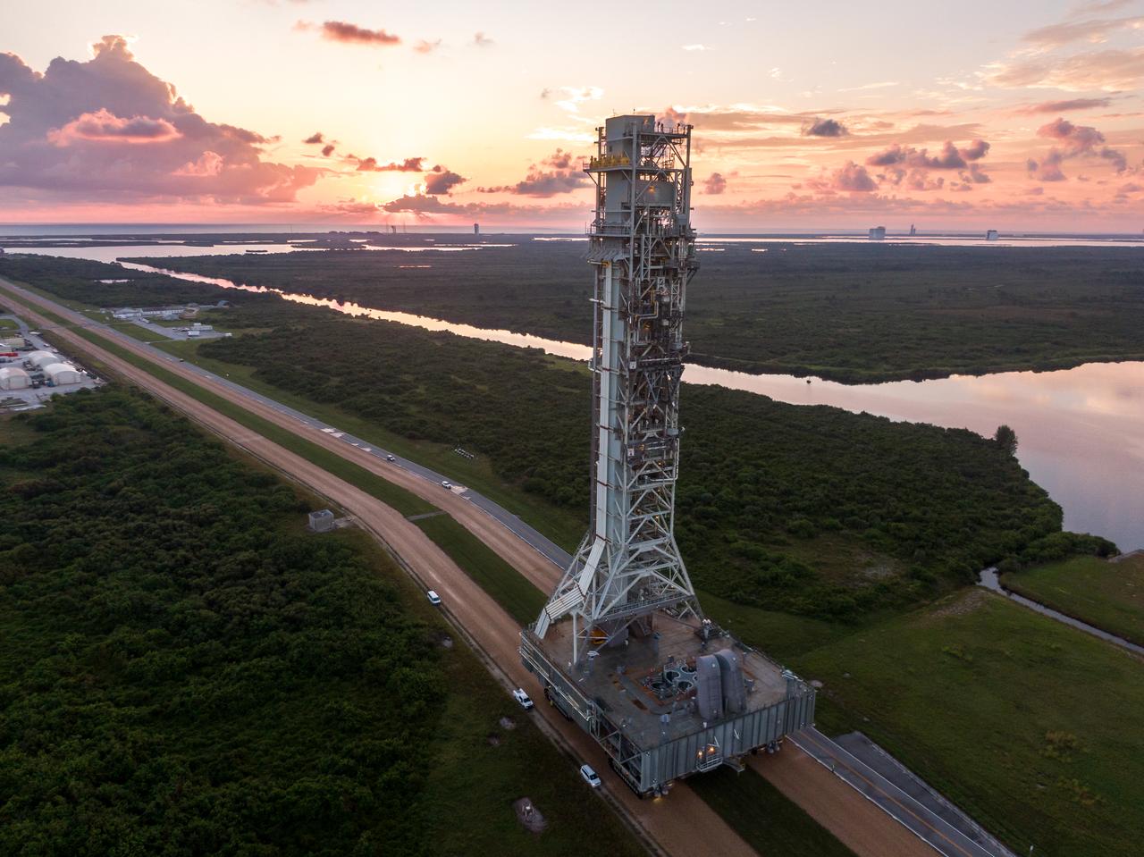
A drone camera captures NASA’s mobile launcher 1 atop the agency’s crawler-transporter 2 moving from Launch Complex 39B to the Vehicle Assembly Building at NASA’s Kennedy Space Center in Florida on Thursday, Oct. 3, 2024. The mobile launcher has been at the launch pad since August 2023 undergoing upgrades and tests in preparation for NASA’s Artemis II mission. The mobile launcher will be used to assemble, process, and launch NASA’s SLS (Space Launch Systems) and Orion spacecraft to the Moon and beyond.
A drone camera captures NASA’s mobile launcher 1 atop the agency’s crawler-transporter 2 moving from Launch Complex 39B approaching to enter the Vehicle Assembly Building at NASA’s Kennedy Space Center in Florida on Thursday, Oct. 3, 2024. The mobile launcher has been at the launch pad since August 2023 undergoing upgrades and tests in preparation for NASA’s Artemis II mission. The mobile launcher will be used to assemble, process, and launch NASA’s SLS (Space Launch Systems) and Orion spacecraft to the Moon and beyond.
An Alta X drone is positioned at altitude for an air launch of the Enhancing Parachutes by Instrumenting the Canopy test experiment on June 4, 2025, at NASA’s Armstong Flight Research Center in Edwards, California. NASA researchers are developing technology to make supersonic parachutes safer and more reliable for delivering science instruments and payloads to Mars.
An Alta X drone air launches the Enhancing Parachutes by Instrumenting the Canopy test experiment on June 4, 2025, at NASA’s Armstong Flight Research Center in Edwards, California. NASA researchers are developing technology to make supersonic parachutes safer and more reliable for delivering science instruments and payloads to Mars.
The Enhancing Parachutes by Instrumenting the Canopy project team examines a capsule and parachute following an air launch from an Alta X drone on June 4, 2025, at NASA’s Armstong Flight Research Center in Edwards, California. NASA researchers are developing technology to make supersonic parachutes safer and more reliable for delivering science instruments and payloads to Mars.
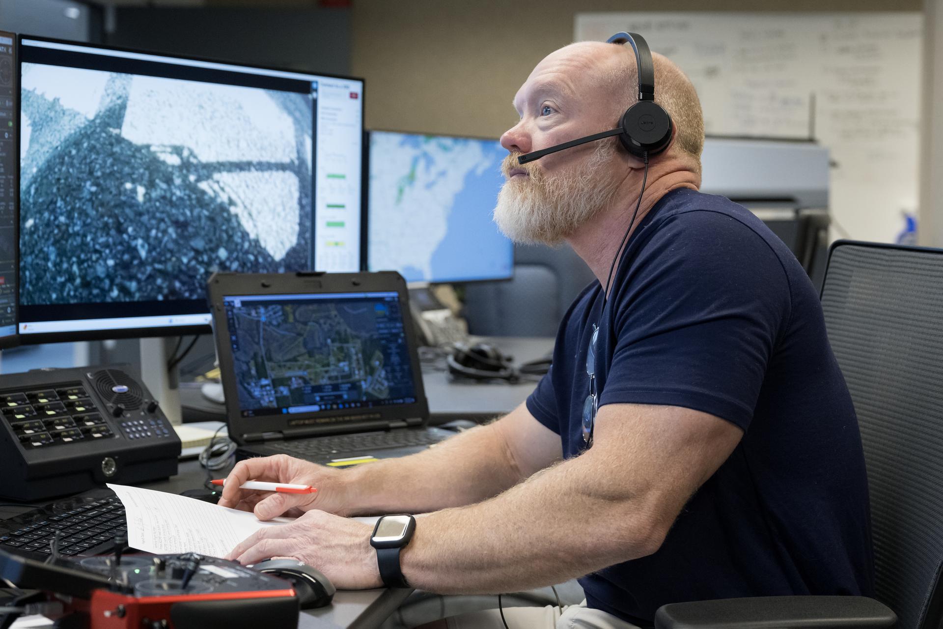
The NASA Airborne Instrumentation for Real-world Video of Urban Environments (AIRVUE) sensor pod is attached to the base of a NASA helicopter at NASA’s Kennedy Space Center in Cape Canaveral, Florida in April 2024 before a flight to test the pod’s cameras and sensors. The AIRVUE pod will be used to collect data for autonomous aircraft like air taxis, drones, or other Advanced Air Mobility aircraft.
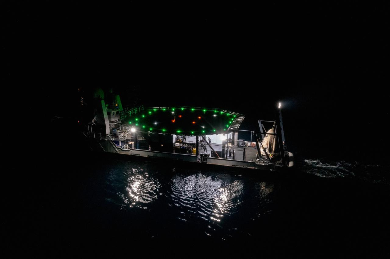
The SpaceX Crew Dragon Resilience splashed down in the Gulf of Mexico off the coast of Panama City, in Florida, at 2:56 a.m. EDT on May 2, 2021. Astronauts Michael Hopkins, Victor Glover, and Shannon Walker of NASA, and Soichi Noguchi of JAXA (Japan Aerospace Exploration Agency) completed Crew-1, the first crew rotation mission to the International Space Station in partnership with NASA as part of the agency’s Commercial Crew Program. Teams on the Go Navigator recovery ship, including two fast boats, work to secure and hoist Crew Dragon onto the main deck of the recovery ship with the astronauts inside.
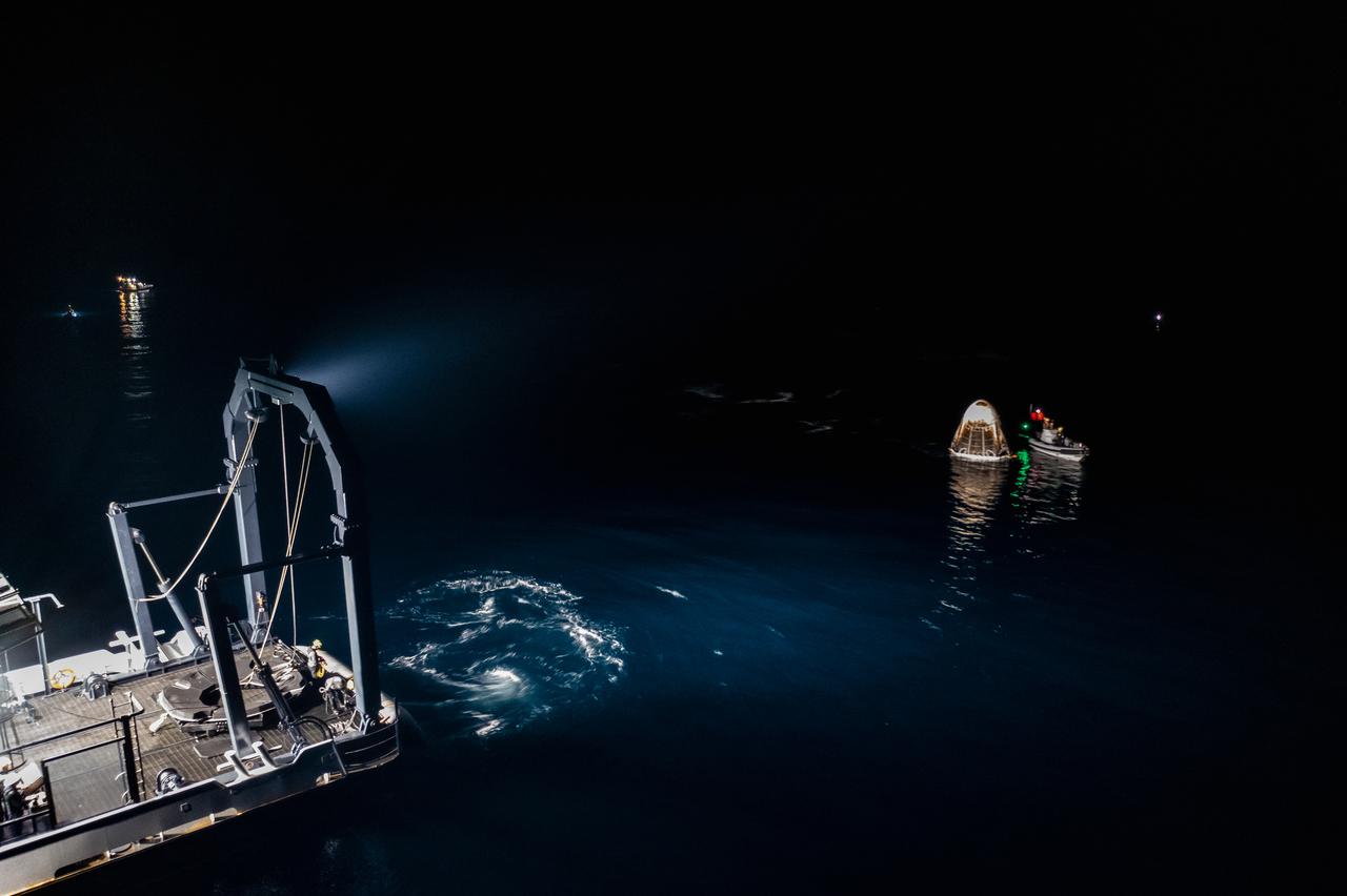
The SpaceX Crew Dragon Resilience splashes down in the Gulf of Mexico off the coast of Panama City, in Florida, at 2:56 a.m. EDT on May 2, 2021. Astronauts Michael Hopkins, Victor Glover, and Shannon Walker of NASA, and Soichi Noguchi of JAXA (Japan Aerospace Exploration Agency) completed Crew-1, the first crew rotation mission to the International Space Station in partnership with NASA as part of the agency’s Commercial Crew Program. At left is SpaceX’s Go Navigator recovery ship. Crew Dragon will be secured and then hoisted onto the main deck of the recovery ship with the astronauts inside.
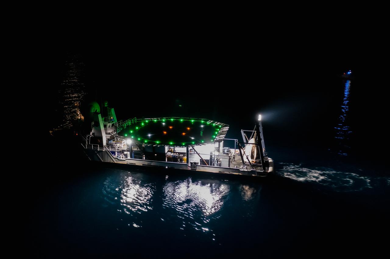
The SpaceX Crew Dragon Resilience splashed down in the Gulf of Mexico off the coast of Panama City, in Florida, at 2:56 a.m. EDT on May 2, 2021. Astronauts Michael Hopkins, Victor Glover, and Shannon Walker of NASA, and Soichi Noguchi of JAXA (Japan Aerospace Exploration Agency) completed Crew-1, the first crew rotation mission to the International Space Station in partnership with NASA as part of the agency’s Commercial Crew Program. Teams on the Go Navigator recovery ship, including two fast boats, work to secure and hoist Crew Dragon onto the main deck of the recovery ship with the astronauts inside.
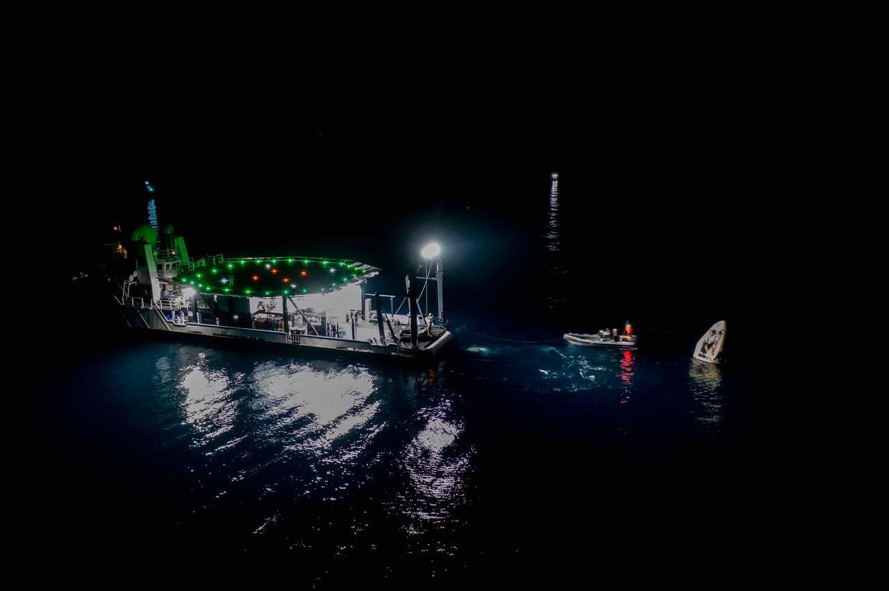
The SpaceX Crew Dragon Resilience splashes down in the Gulf of Mexico off the coast of Panama City, in Florida, at 2:56 a.m. EDT on May 2, 2021. Astronauts Michael Hopkins, Victor Glover, and Shannon Walker of NASA, and Soichi Noguchi of JAXA (Japan Aerospace Exploration Agency) completed Crew-1, the first crew rotation mission to the International Space Station in partnership with NASA as part of the agency’s Commercial Crew Program. At left is SpaceX’s Go Navigator recovery ship. Teams on two fast boats and Go Navigator will secure Crew Dragon to be hoisted onto the main deck of the recovery ship with the astronauts inside.
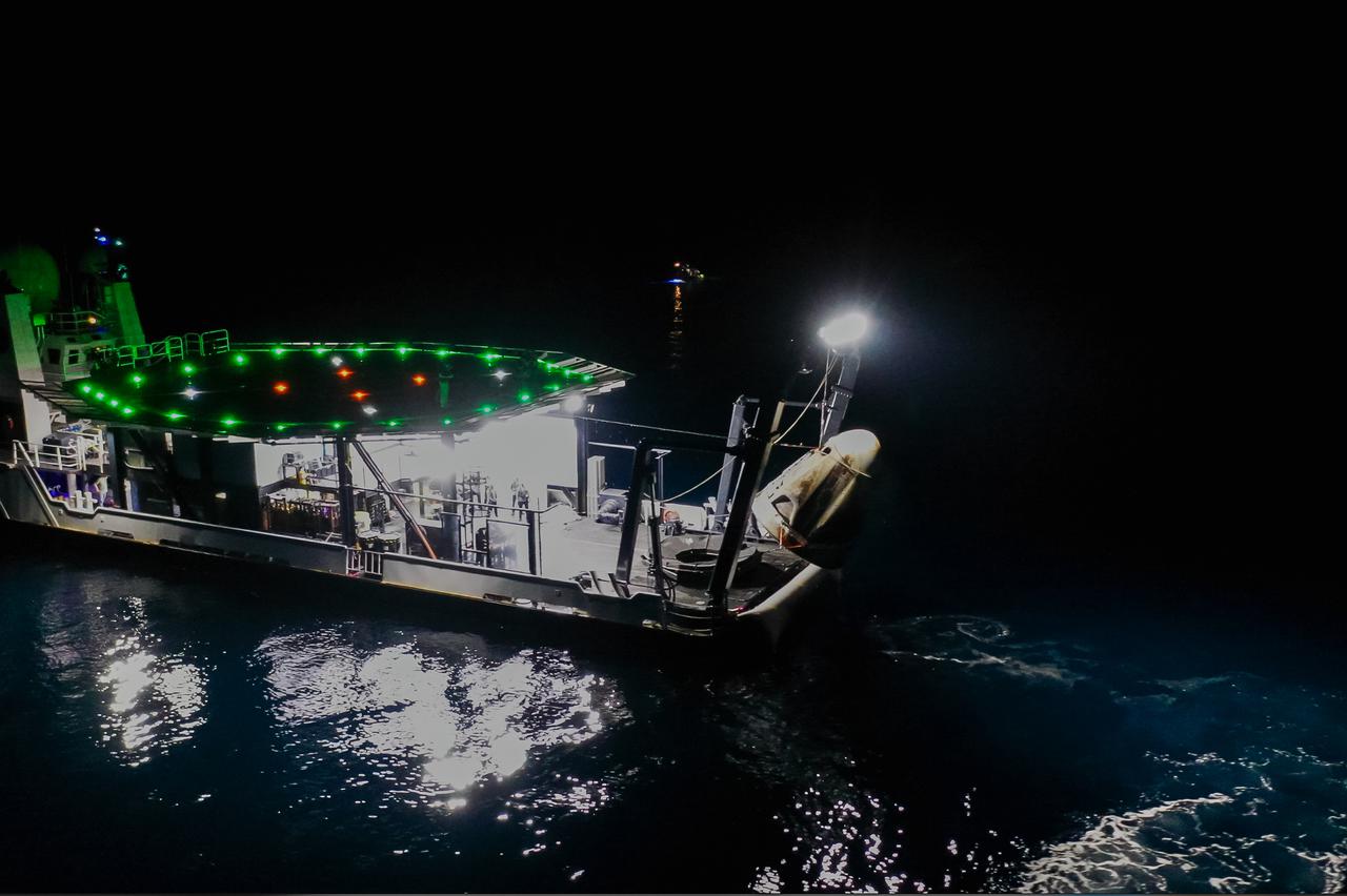
The SpaceX Crew Dragon Resilience splashed down in the Gulf of Mexico off the coast of Panama City, in Florida, at 2:56 a.m. EDT on May 2, 2021. Astronauts Michael Hopkins, Victor Glover, and Shannon Walker of NASA, and Soichi Noguchi of JAXA (Japan Aerospace Exploration Agency) completed Crew-1, the first crew rotation mission to the International Space Station in partnership with NASA as part of the agency’s Commercial Crew Program. Teams on the Go Navigator recovery ship, including two fast boats, work to secure and hoist Crew Dragon onto the main deck of the recovery ship with the astronauts inside.
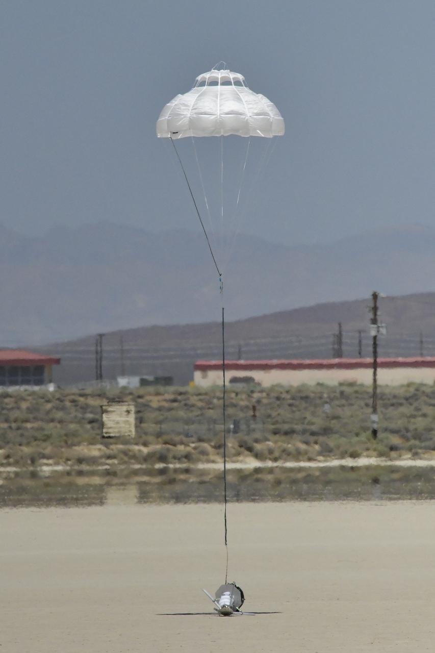
The Enhancing Parachutes by Instrumenting the Canopy test experiment lands following an air launch from an Alta X drone on June 4, 2025, at NASA’s Armstong Flight Research Center in Edwards, California. NASA researchers are developing technology to make supersonic parachutes safer and more reliable for delivering science instruments and payloads to Mars.
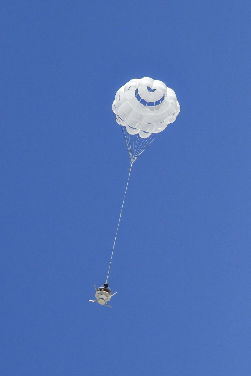
The parachute of the Enhancing Parachutes by Instrumenting the Canopy test experiment deploys following an air launch from an Alta X drone on June 4, 2025, at NASA’s Armstong Flight Research Center in Edwards, California. NASA researchers are developing technology to make supersonic parachutes safer and more reliable for delivering science instruments and payloads to Mars.
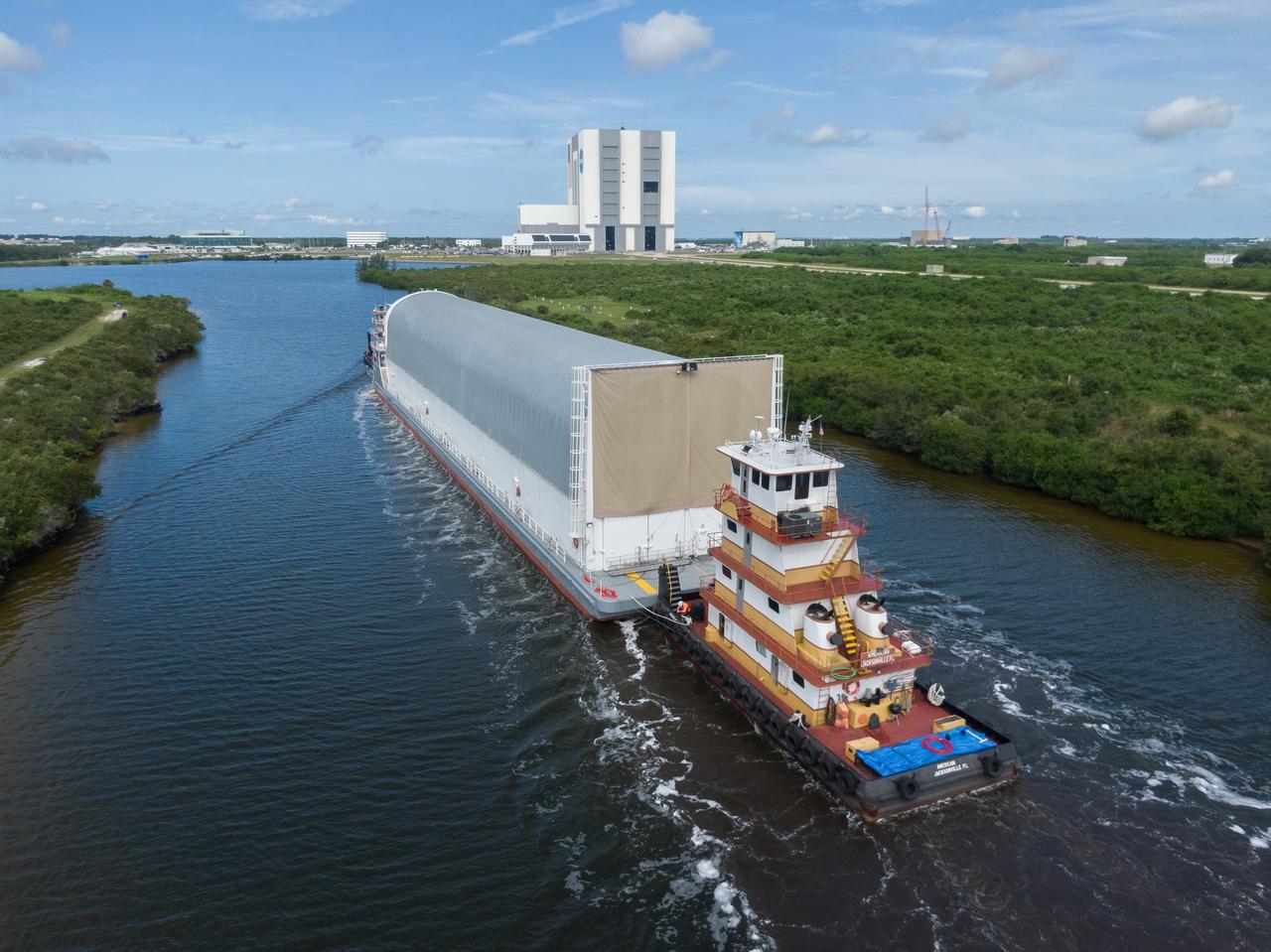
Drone Crew and Media Services document the Intertank STA en route to Pegasus.
NASA researcher A.J. Jaffe prepares the NASA Airborne Instrumentation for Real-world Video of Urban Environments (AIRVUE) sensor pod for testing at NASA’s Kennedy Space Center in Cape Canaveral, Florida in April 2024. The AIRVUE pod will be used to collect data for autonomous aircraft like air taxis, drones, or other Advanced Air Mobility aircraft.
NASA researchers Elizabeth Nail (foreground) and A.J. Jaffe (background) prepare the NASA Airborne Instrumentation for Real-world Video of Urban Environments (AIRVUE) sensor pod for testing at NASA’s Kennedy Space Center in Cape Canaveral, Florida in April 2024. The AIRVUE pod will be used to collect data for autonomous aircraft like air taxis, drones, or other Advanced Air Mobility aircraft.
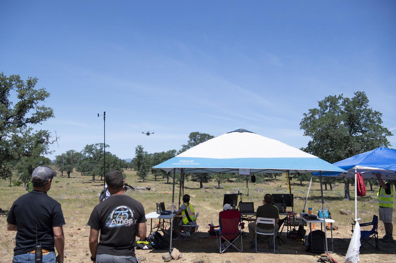
A computer displays the flight path of a FreeFly Systems Alta X drone during a flight as part of STEReO, the Scalable Traffic Management for Emergency Response Operations project, test activities, Tuesday, May 4, 2021 as Cal Fire conducts aerial fire fighting training exercises near Redding, California. STEReO, the Scalable Traffic Management for Emergency Response Operations project, led by NASA’s Ames Research Center, builds on NASA’s expertise in air traffic management, human factors research, and autonomous technology development to apply the agency’s work in Unmanned Aircraft Systems Traffic Management, or UTM, to public safety uses. Photo Credit: (NASA/Joel Kowsky)
Richard Kolyer unfolds the drone and prepares it for flight around the modified C-141 Kuiper Airborne Observatory, (KAO) (NASA-714).
S86-29996 (16 March 1986) --- Deep Drone contact #192 dive 54. (st)
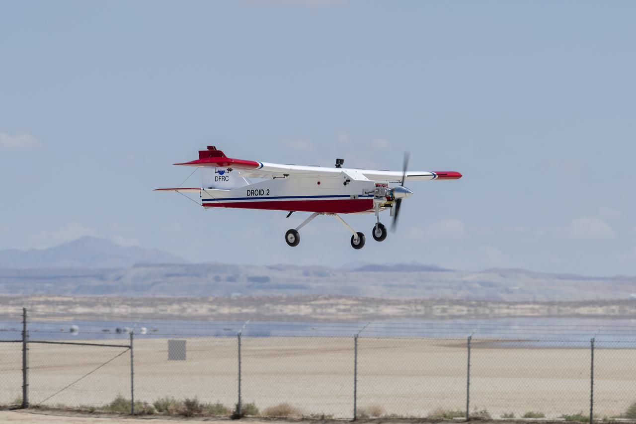
The DROID 2 (Dryden Remotely Operated Integrated Drone 2) prepares to land at NASA's Armstrong Flight Research Center in Edwards, California, as part of the Advanced Exploration of Reliable Operation at Low Altitudes: Meteorology, Simulation, and Technology campaign. The focus was to study wind to provide data for safe takeoff and landing of future air taxis.
The DROID 2 (Dryden Remotely Operated Integrated Drone 2) flies at NASA's Armstrong Flight Research Center in Edwards, California, as part of the Advanced Exploration of Reliable Operation at Low Altitudes: Meteorology, Simulation, and Technology campaign. The focus was to study wind to provide data for safe takeoff and landing of future air taxis.
S86-30363 (13 March 1986) --- Deep Drone Dive #52 March 13, 1986, OCC contact 191 Photosea 1200 camera. (fc)
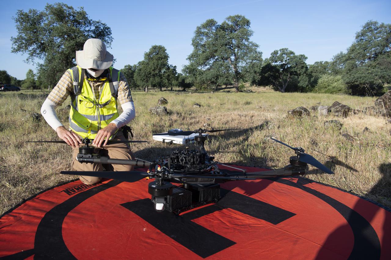
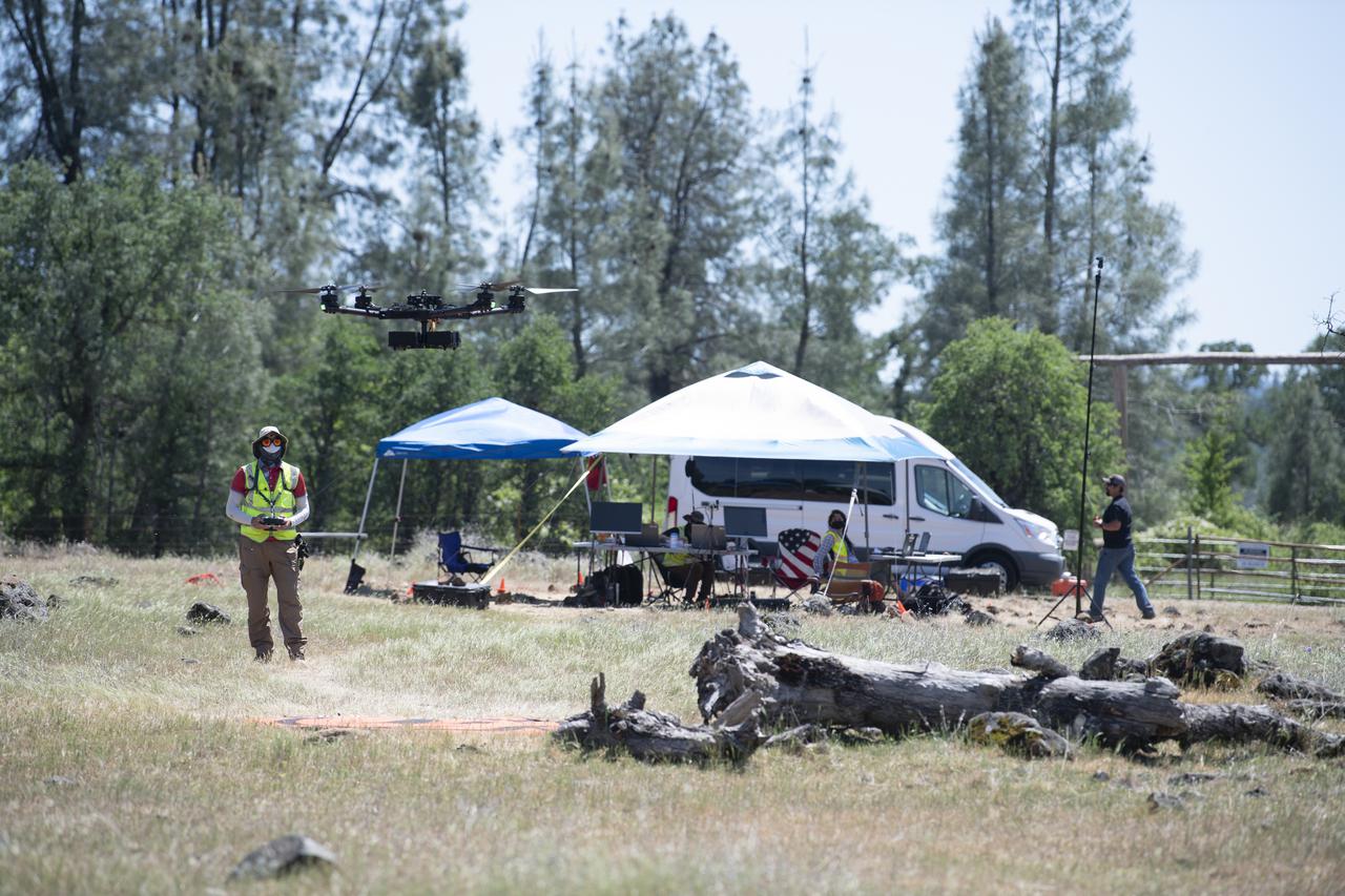
Jonas Jonsson, pilot in command for STEReO, the Scalable Traffic Management for Emergency Response Operations project, at NASA's Ames Research Center, performs pre-flight checks on a FreeFly Systems Alta X drone, Wednesday, May 5, 2021 as Cal Fire conducts aerial fire fighting training exercises near Redding, California. STEReO, the Scalable Traffic Management for Emergency Response Operations project, led by NASA’s Ames Research Center, builds on NASA’s expertise in air traffic management, human factors research, and autonomous technology development to apply the agency’s work in Unmanned Aircraft Systems Traffic Management, or UTM, to public safety uses. Photo Credit: (NASA/Joel Kowsky)
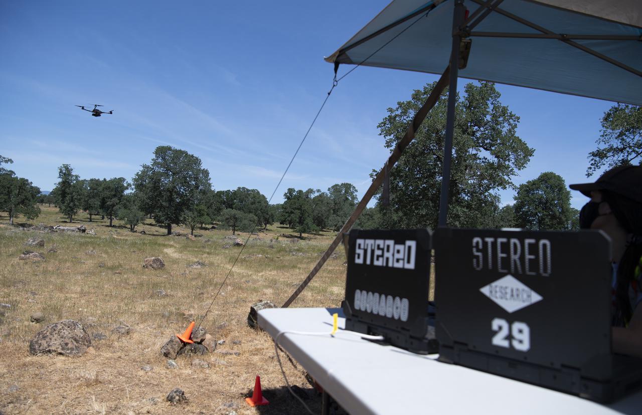
A FreeFly Systems Alta X drone is seen in flight as part of STEReO, the Scalable Traffic Management for Emergency Response Operations project, test activities, Tuesday, May 4, 2021 as Cal Fire conducts aerial fire fighting training exercises near Redding, California. STEReO, the Scalable Traffic Management for Emergency Response Operations project, led by NASA’s Ames Research Center, builds on NASA’s expertise in air traffic management, human factors research, and autonomous technology development to apply the agency’s work in Unmanned Aircraft Systems Traffic Management, or UTM, to public safety uses. Photo Credit: (NASA/Joel Kowsky)
Jonas Jonsson, pilot in command for STEReO, the Scalable Traffic Management for Emergency Response Operations project, at NASA's Ames Research Center, performs pre-flight checks on a FreeFly Systems Alta X drone, Wednesday, May 5, 2021 as Cal Fire conducts aerial fire fighting training exercises near Redding, California. STEReO, the Scalable Traffic Management for Emergency Response Operations project, led by NASA’s Ames Research Center, builds on NASA’s expertise in air traffic management, human factors research, and autonomous technology development to apply the agency’s work in Unmanned Aircraft Systems Traffic Management, or UTM, to public safety uses. Photo Credit: (NASA/Joel Kowsky)
A FreeFly Systems Alta X drone is seen in flight during STEReO, the Scalable Traffic Management for Emergency Response Operations project, test activities, Tuesday, May 4, 2021 as Cal Fire conducts aerial fire fighting training exercises near Redding, California. STEReO, the Scalable Traffic Management for Emergency Response Operations project, led by NASA’s Ames Research Center, builds on NASA’s expertise in air traffic management, human factors research, and autonomous technology development to apply the agency’s work in Unmanned Aircraft Systems Traffic Management, or UTM, to public safety uses. Photo Credit: (NASA/Joel Kowsky)
A FreeFly Systems Alta X drone is seen in flight during STEReO, the Scalable Traffic Management for Emergency Response Operations project, test activities, Tuesday, May 4, 2021 as Cal Fire conducts aerial fire fighting training exercises near Redding, California. STEReO, the Scalable Traffic Management for Emergency Response Operations project, led by NASA’s Ames Research Center, builds on NASA’s expertise in air traffic management, human factors research, and autonomous technology development to apply the agency’s work in Unmanned Aircraft Systems Traffic Management, or UTM, to public safety uses. Photo Credit: (NASA/Joel Kowsky)
A Cal Fire S2-T airtanker is seen flying past the FreeFly Systems Alta X drone used during STEReO, the Scalable Traffic Management for Emergency Response Operations project, test activities, Wednesday, May 5, 2021 as Cal Fire conducts aerial fire fighting training exercises near Redding, California. STEReO, the Scalable Traffic Management for Emergency Response Operations project, led by NASA’s Ames Research Center, builds on NASA’s expertise in air traffic management, human factors research, and autonomous technology development to apply the agency’s work in Unmanned Aircraft Systems Traffic Management, or UTM, to public safety uses. Photo Credit: (NASA/Joel Kowsky)
Jonas Jonsson, pilot in command for STEReO, the Scalable Traffic Management for Emergency Response Operations project, at NASA's Ames Research Center, performs pre-flight checks on a FreeFly Systems Alta X drone, Wednesday, May 5, 2021 as Cal Fire conducts aerial fire fighting training exercises near Redding, California. STEReO, the Scalable Traffic Management for Emergency Response Operations project, led by NASA’s Ames Research Center, builds on NASA’s expertise in air traffic management, human factors research, and autonomous technology development to apply the agency’s work in Unmanned Aircraft Systems Traffic Management, or UTM, to public safety uses. Photo Credit: (NASA/Joel Kowsky)
Jonas Jonsson, pilot in command for STEReO, the Scalable Traffic Management for Emergency Response Operations project, at NASA's Ames Research Center, performs pre-flight checks on a FreeFly Systems Alta X drone, Wednesday, May 5, 2021 as Cal Fire conducts aerial fire fighting training exercises near Redding, California. STEReO, the Scalable Traffic Management for Emergency Response Operations project, led by NASA’s Ames Research Center, builds on NASA’s expertise in air traffic management, human factors research, and autonomous technology development to apply the agency’s work in Unmanned Aircraft Systems Traffic Management, or UTM, to public safety uses. Photo Credit: (NASA/Joel Kowsky)
Jonas Jonsson, pilot in command for STEReO, the Scalable Traffic Management for Emergency Response Operations project, at NASA's Ames Research Center, performs pre-flight checks on a FreeFly Systems Alta X drone, Wednesday, May 5, 2021 as Cal Fire conducts aerial fire fighting training exercises near Redding, California. STEReO, the Scalable Traffic Management for Emergency Response Operations project, led by NASA’s Ames Research Center, builds on NASA’s expertise in air traffic management, human factors research, and autonomous technology development to apply the agency’s work in Unmanned Aircraft Systems Traffic Management, or UTM, to public safety uses. Photo Credit: (NASA/Joel Kowsky)
A FreeFly Systems Alta X drone is seen in flight during STEReO, the Scalable Traffic Management for Emergency Response Operations project, test activities, Tuesday, May 4, 2021 as Cal Fire conducts aerial fire fighting training exercises near Redding, California. STEReO, the Scalable Traffic Management for Emergency Response Operations project, led by NASA’s Ames Research Center, builds on NASA’s expertise in air traffic management, human factors research, and autonomous technology development to apply the agency’s work in Unmanned Aircraft Systems Traffic Management, or UTM, to public safety uses. Photo Credit: (NASA/Joel Kowsky)
A FreeFly Systems Alta X drone is seen in flight during STEReO, the Scalable Traffic Management for Emergency Response Operations project, test activities, Tuesday, May 4, 2021 as Cal Fire conducts aerial fire fighting training exercises near Redding, California. STEReO, the Scalable Traffic Management for Emergency Response Operations project, led by NASA’s Ames Research Center, builds on NASA’s expertise in air traffic management, human factors research, and autonomous technology development to apply the agency’s work in Unmanned Aircraft Systems Traffic Management, or UTM, to public safety uses. Photo Credit: (NASA/Joel Kowsky)
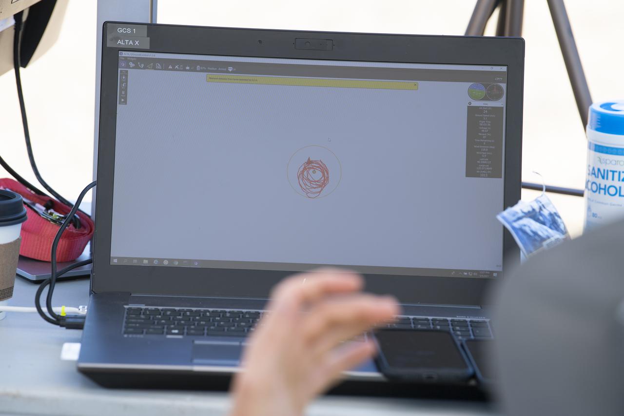
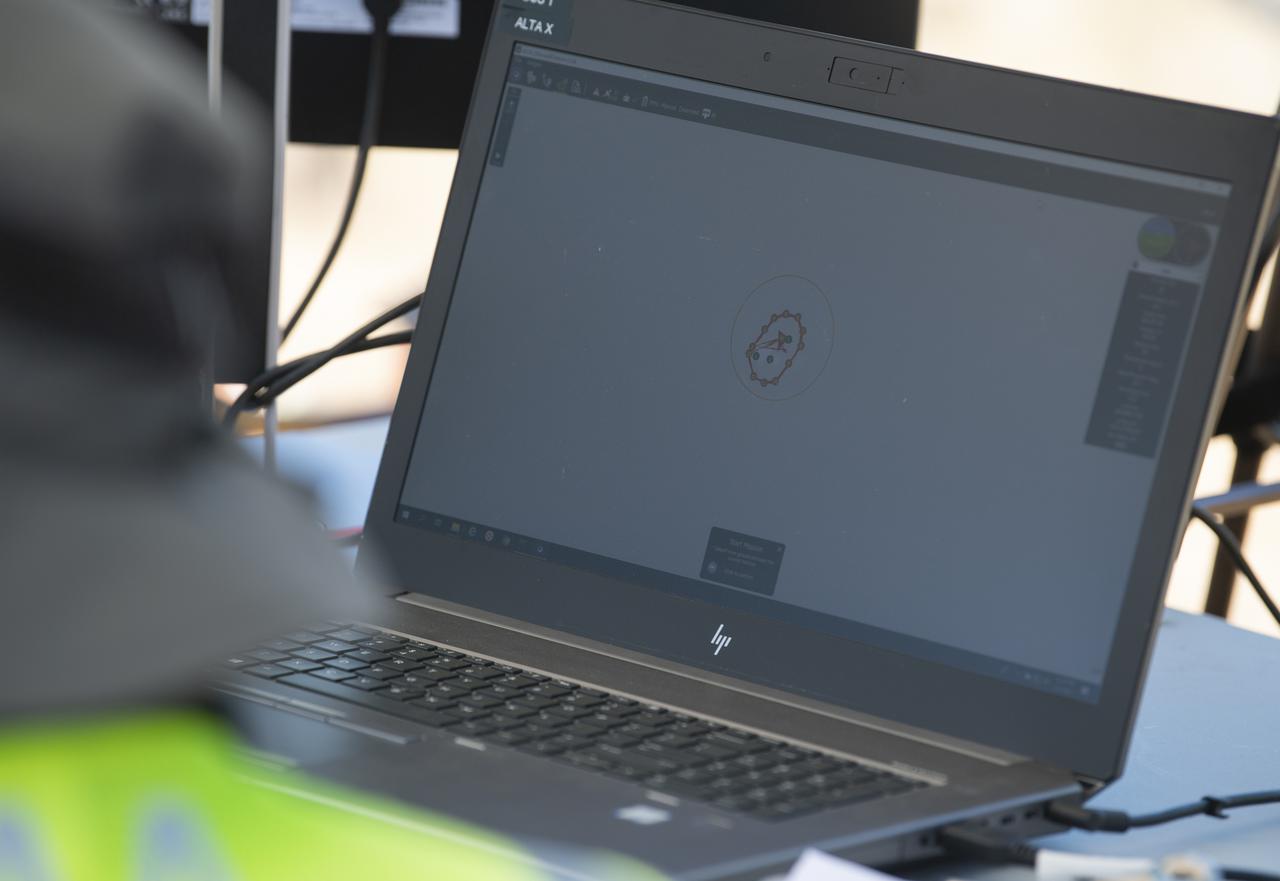
A laptop displays the flight path of a FreeFly Systems Alta X drone during STEReO, the Scalable Traffic Management for Emergency Response Operations project, field testing, Wednesday, May 5, 2021 as Cal Fire conducts aerial fire fighting training exercises near Redding, California. STEReO, the Scalable Traffic Management for Emergency Response Operations project, led by NASA’s Ames Research Center, builds on NASA’s expertise in air traffic management, human factors research, and autonomous technology development to apply the agency’s work in Unmanned Aircraft Systems Traffic Management, or UTM, to public safety uses. Photo Credit: (NASA/Joel Kowsky)
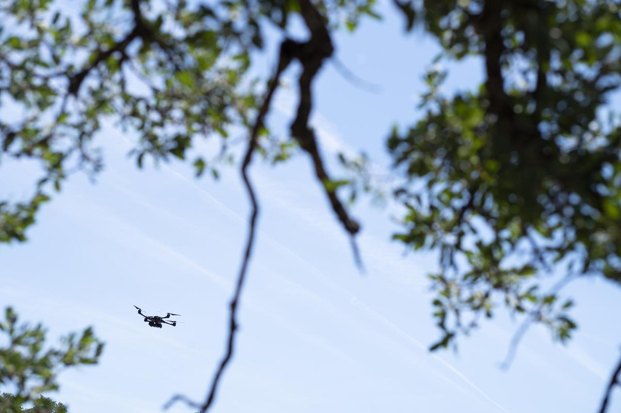
A FreeFly Systems Alta X drone is seen in flight during STEReO, the Scalable Traffic Management for Emergency Response Operations project, field testing, Wednesday, May 5, 2021 as Cal Fire conducts aerial fire fighting training exercises near Redding, California. STEReO, the Scalable Traffic Management for Emergency Response Operations project, led by NASA’s Ames Research Center, builds on NASA’s expertise in air traffic management, human factors research, and autonomous technology development to apply the agency’s work in Unmanned Aircraft Systems Traffic Management, or UTM, to public safety uses. Photo Credit: (NASA/Joel Kowsky)
A FreeFly Systems Alta X drone is seen in flight as part of STEReO, the Scalable Traffic Management for Emergency Response Operations project, test activities, Tuesday, May 4, 2021 as Cal Fire conducts aerial fire fighting training exercises near Redding, California. STEReO, the Scalable Traffic Management for Emergency Response Operations project, led by NASA’s Ames Research Center, builds on NASA’s expertise in air traffic management, human factors research, and autonomous technology development to apply the agency’s work in Unmanned Aircraft Systems Traffic Management, or UTM, to public safety uses. Photo Credit: (NASA/Joel Kowsky)

Jonas Jonsson, pilot in command for STEReO, the Scalable Traffic Management for Emergency Response Operations project, at NASA's Ames Research Center, performs pre-flight checks on a FreeFly Systems Alta X drone, Wednesday, May 5, 2021 as Cal Fire conducts aerial fire fighting training exercises near Redding, California. STEReO, the Scalable Traffic Management for Emergency Response Operations project, led by NASA’s Ames Research Center, builds on NASA’s expertise in air traffic management, human factors research, and autonomous technology development to apply the agency’s work in Unmanned Aircraft Systems Traffic Management, or UTM, to public safety uses. Photo Credit: (NASA/Joel Kowsky)
A laptop displays the flight path of a FreeFly Systems Alta X drone during STEReO, the Scalable Traffic Management for Emergency Response Operations project, field testing, Wednesday, May 5, 2021 as Cal Fire conducts aerial fire fighting training exercises near Redding, California. STEReO, the Scalable Traffic Management for Emergency Response Operations project, led by NASA’s Ames Research Center, builds on NASA’s expertise in air traffic management, human factors research, and autonomous technology development to apply the agency’s work in Unmanned Aircraft Systems Traffic Management, or UTM, to public safety uses. Photo Credit: (NASA/Joel Kowsky)
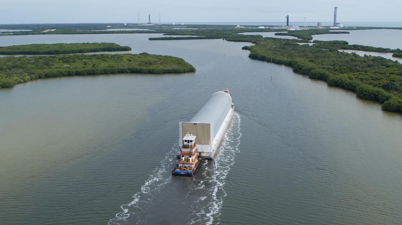
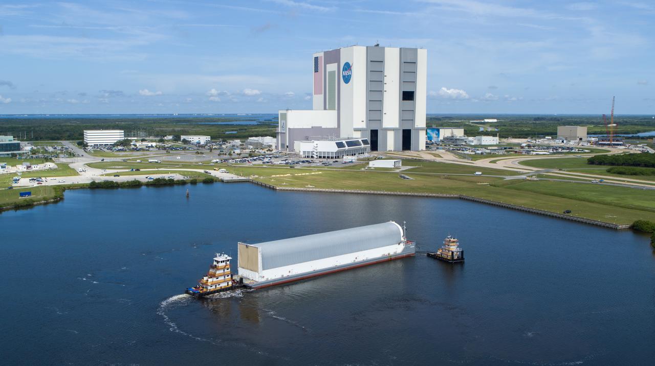
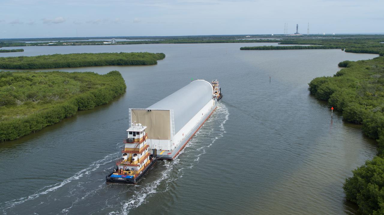
In this aerial view, NASA’s Pegasus barge, carrying the agency’s massive SLS (Space Launch System) core stage, arrives at NASA’s Kennedy Space Center Complex 39 turn basin wharf in Florida on Tuesday, July 23, 2024, after journeying from the agency’s Michoud Assembly Facility in New Orleans. The core stage is the next piece of Artemis hardware to arrive at the spaceport and will be offloaded and moved to NASA Kennedy’s Vehicle Assembly Building, where it will be prepared for integration ahead of the Artemis II launch.

In this aerial view, NASA’s Pegasus barge, carrying the agency’s massive SLS (Space Launch System) core stage, arrives at NASA’s Kennedy Space Center Complex 39 turn basin wharf in Florida on Tuesday, July 23, 2024, after journeying from the agency’s Michoud Assembly Facility in New Orleans. The core stage is the next piece of Artemis hardware to arrive at the spaceport and will be offloaded and moved to NASA Kennedy’s Vehicle Assembly Building, where it will be prepared for integration ahead of the Artemis II launch.
In this aerial view, NASA’s Pegasus barge, carrying the agency’s massive SLS (Space Launch System) core stage, arrives at NASA’s Kennedy Space Center Complex 39 turn basin wharf in Florida on Tuesday, July 23, 2024, after journeying from the agency’s Michoud Assembly Facility in New Orleans. The core stage is the next piece of Artemis hardware to arrive at the spaceport and will be offloaded and moved to NASA Kennedy’s Vehicle Assembly Building, where it will be prepared for integration ahead of the Artemis II launch.
In this aerial view, NASA’s Pegasus barge, carrying the agency’s massive SLS (Space Launch System) core stage, arrives at NASA’s Kennedy Space Center Complex 39 turn basin wharf in Florida on Tuesday, July 23, 2024, after journeying from the agency’s Michoud Assembly Facility in New Orleans. The core stage is the next piece of Artemis hardware to arrive at the spaceport and will be offloaded and moved to NASA Kennedy’s Vehicle Assembly Building, where it will be prepared for integration ahead of the Artemis II launch.
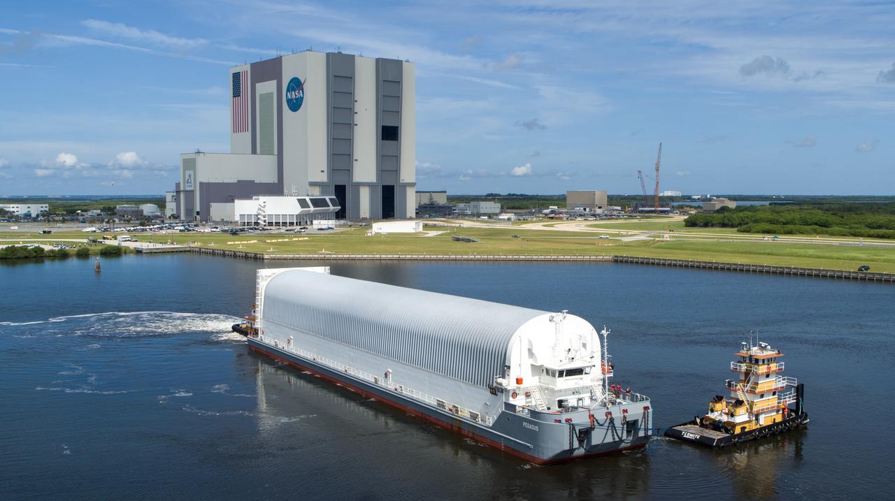
In this aerial view, NASA’s Pegasus barge, carrying the agency’s massive SLS (Space Launch System) core stage, arrives at NASA’s Kennedy Space Center Complex 39 turn basin wharf in Florida on Tuesday, July 23, 2024, after journeying from the agency’s Michoud Assembly Facility in New Orleans. The core stage is the next piece of Artemis hardware to arrive at the spaceport and will be offloaded and moved to NASA Kennedy’s Vehicle Assembly Building, where it will be prepared for integration ahead of the Artemis II launch.
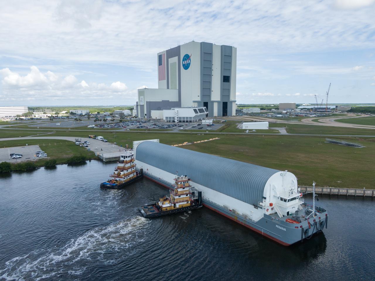
In this aerial view, NASA’s Pegasus barge, carrying the agency’s massive SLS (Space Launch System) core stage, arrives at NASA’s Kennedy Space Center Complex 39 turn basin wharf in Florida on Tuesday, July 23, 2024, after journeying from the agency’s Michoud Assembly Facility in New Orleans. The core stage is the next piece of Artemis hardware to arrive at the spaceport and will be offloaded and moved to NASA Kennedy’s Vehicle Assembly Building, where it will be prepared for integration ahead of the Artemis II launch.
In this aerial view, NASA’s Pegasus barge, carrying the agency’s massive SLS (Space Launch System) core stage, arrives at NASA’s Kennedy Space Center Complex 39 turn basin wharf in Florida on Tuesday, July 23, 2024, after journeying from the agency’s Michoud Assembly Facility in New Orleans. The core stage is the next piece of Artemis hardware to arrive at the spaceport and will be offloaded and moved to NASA Kennedy’s Vehicle Assembly Building, where it will be prepared for integration ahead of the Artemis II launch.

The Alta-X aircraft flies by the former space shuttle hangar at NASA’s Armstrong Flight Research Center in Edwards, California, as part of the Advanced Exploration of Reliable Operation at Low Altitudes: Meteorology, Simulation and Technology campaign. The campaign was at NASA Armstrong to study wind from the ground to 2,000 feet to provide data to assist future drones to safely land on rooftop hubs called vertiports and to potentially improve weather prediction.
The Alta-X aircraft flies at NASA’s Armstrong Flight Research Center in Edwards, California, as part of the Advanced Exploration of Reliable Operation at Low Altitudes: Meteorology, Simulation and Technology campaign. The campaign was at NASA Armstrong to study wind from the ground to 2,000 feet to provide data to assist future drones to safely land on rooftop hubs called vertiports and to potentially improve weather prediction.
Robert "Red" Jensen positions the DROID 2 (Dryden Remotely Operated Integrated Drone) aircraft before a flight for the Advanced Exploration of Reliable Operation at Low Altitudes: Meteorology, Simulation, and Technology campaign. The weather study was at NASA's Armstrong Flight Research Center in Edwards, California. The focus was to study wind to provide data for safe takeoff and landing of future air taxis.
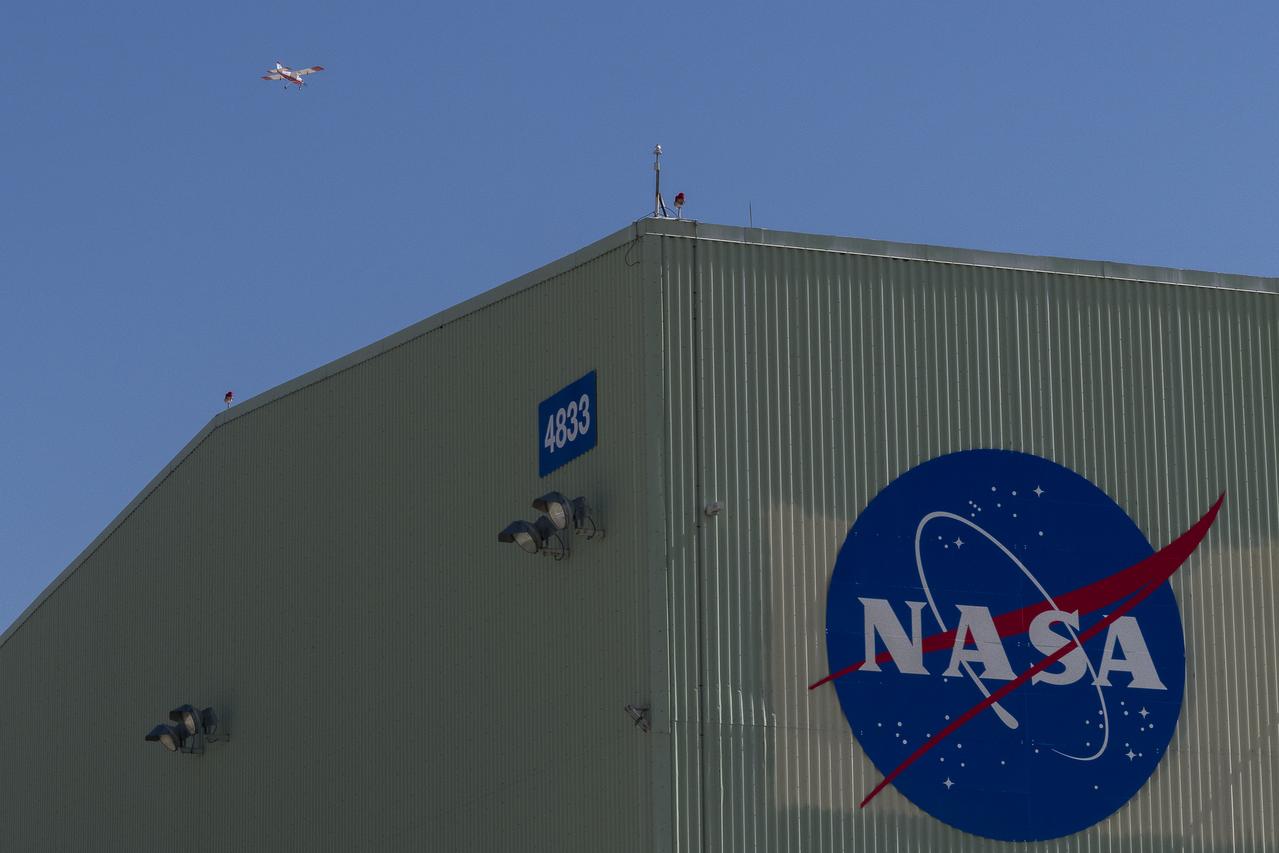
This is one of two lidar units positioned on either end of Building 4833 at NASA’s Armstrong Flight Research Center in Edwards, California, that formed the cutting-edge ‘virtual tower concept.’ The units use lasers to measure airflow from the ground level to 2,000 feet to provide data to assist future drones to safely land on rooftop hubs called vertiports, and to potentially improve weather prediction. It was part of the multi-faceted Advanced Exploration of Reliable Operation at Low Altitudes: Meteorology, Simulation and Technology campaign.
Justin Link prepares the DROID 2 (Dryden Remotely Operated Integrated Drone 2) aircraft before a flight for the Advanced Exploration of Reliable Operation at Low Altitudes: Meteorology, Simulation, and Technology campaign. The weather study was at NASA's Armstrong Flight Research Center in Edwards, California. The focus was to study wind to provide data for safe takeoff and landing of future air taxis.
The Alta-X aircraft flies by the former space shuttle hangar at NASA’s Armstrong Flight Research Center in Edwards, California, as part of the Advanced Exploration of Reliable Operation at Low Altitudes: Meteorology, Simulation and Technology campaign. The campaign was at NASA Armstrong Flight to study wind from the ground to 2,000 feet to provide data to assist future drones to safely land on rooftop hubs called vertiports and to potentially improve weather prediction.
The DROID 2 (Dryden Remotely Operated Integrated Drone 2) aircraft flies by the former space shuttle hangar at NASA's Armstrong Flight Research Center in Edwards, California, as part of the Advanced Exploration of Reliable Operation at Low Altitudes: Meteorology, Simulation, and Technology campaign. The focus was to study wind to provide data for safe takeoff and landing of future air taxis.