
A Pearl at Dusk
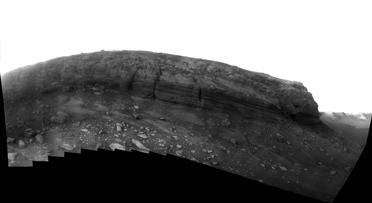
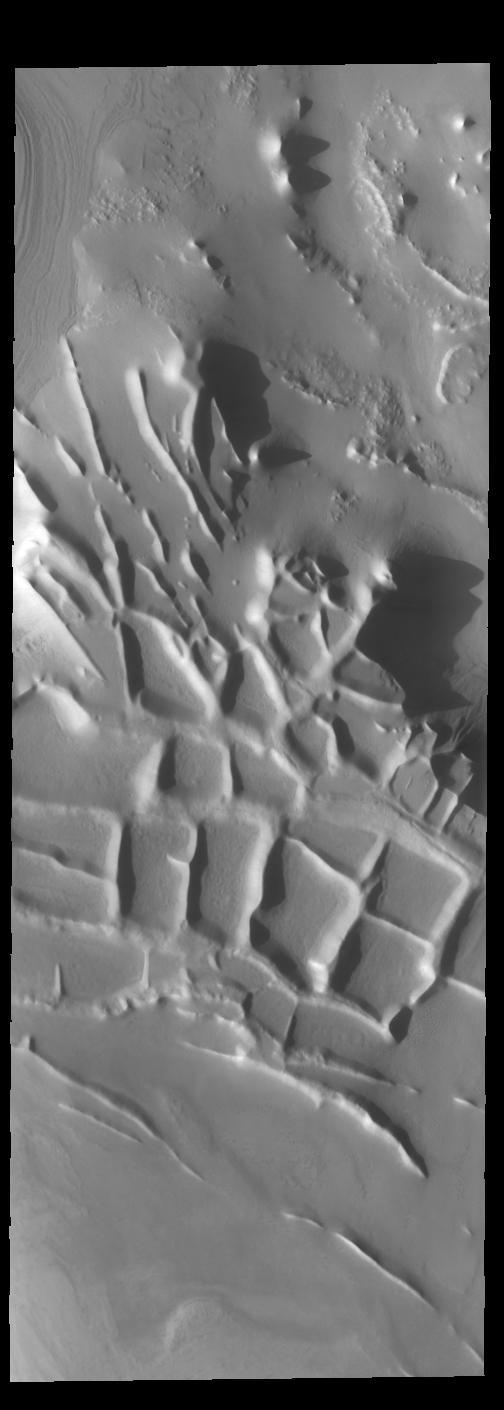
Dusk Lighting of Layered Textures in Cape Verde
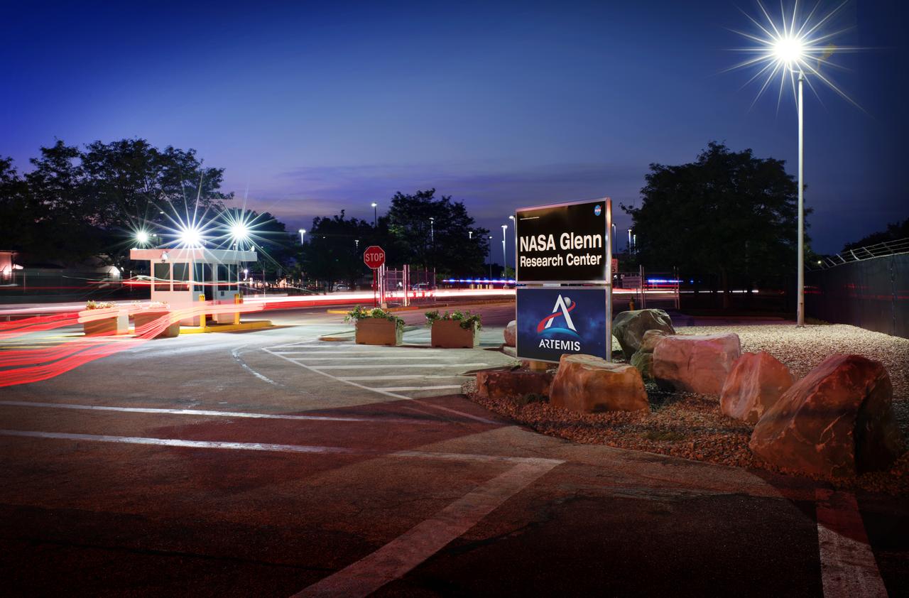
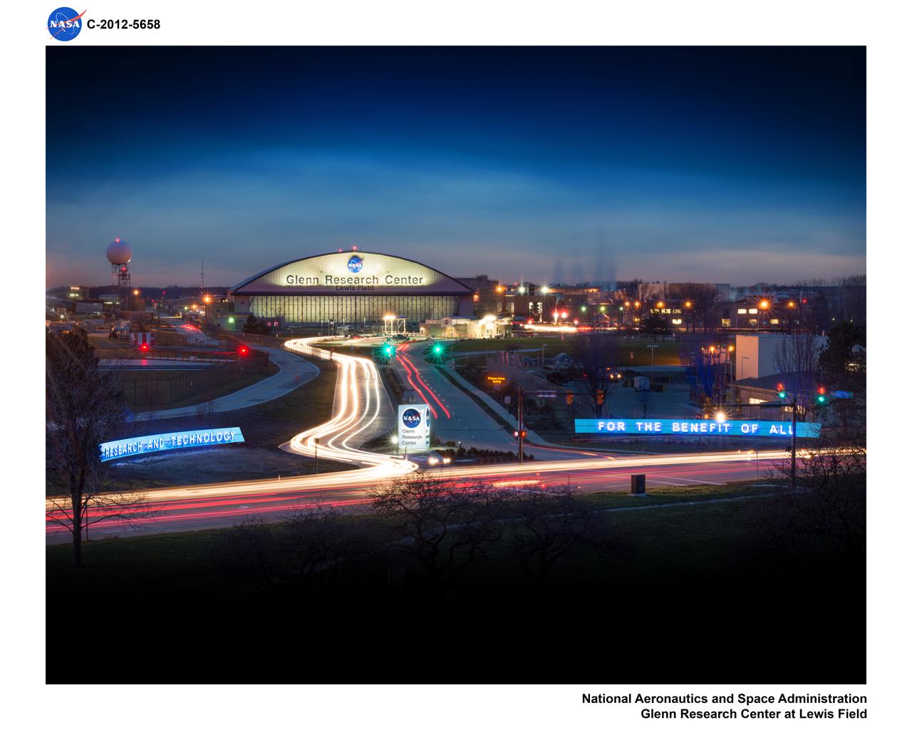
The newly renovated NASA Glenn Research Center, GRC Lewis Field West Gate at dusk.
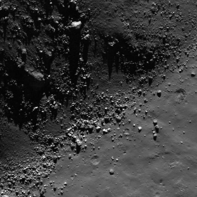
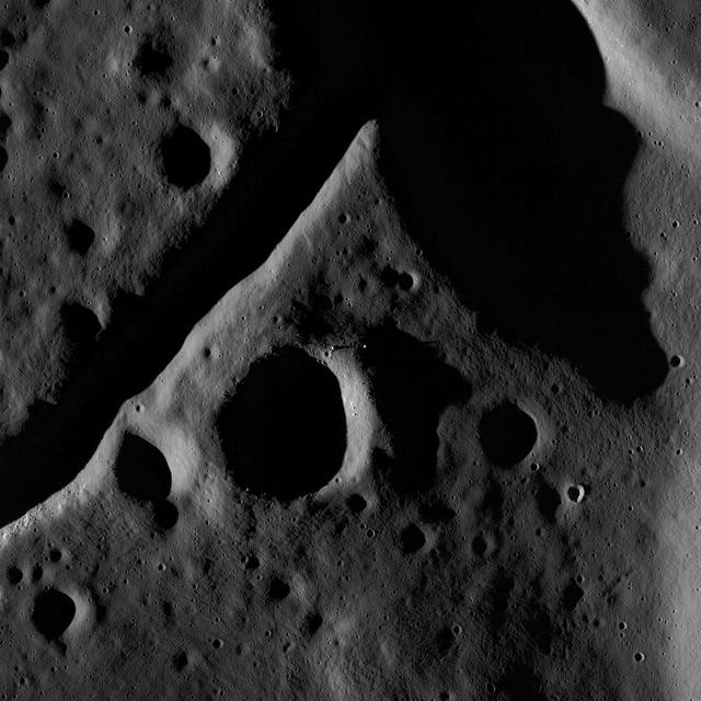
This image from NASA Lunar Reconnaissance Orbiter shows a view of boulders, on the floor of Rutherfurd crater, about to disappear into the shadows of dusk.
This image from NASA Lunar Reconnaissance Orbiter shows a view of boulders, on the floor of Rutherfurd crater, about to disappear into the shadows of dusk.
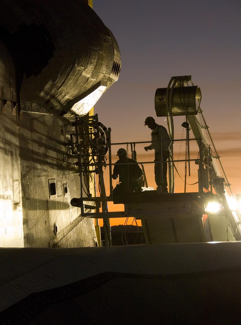
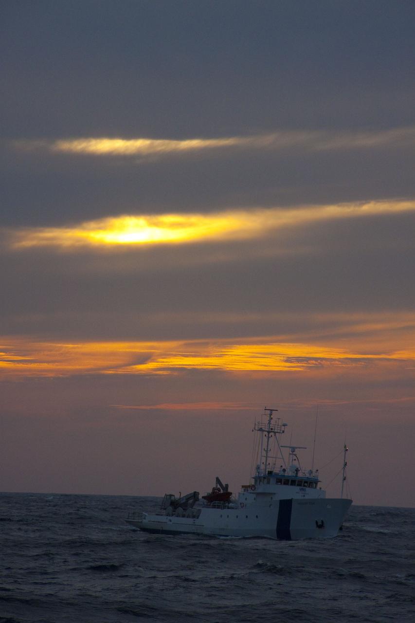
As dusk settles over Edwards Air Force Base, NASA technicians hook up various ground-support systems before shuttle Endeavour is towed off the landing runway.

Mission Integration Center Building at Dusk
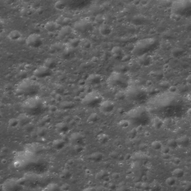
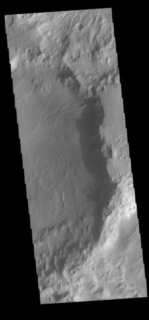
The central peak and fractured floor of Compton crater as imaged by the LROC Narrow Angle Camera onboard NASA Lunar Reconnaissance Orbiter at dusk, image width is ~1720 meters.
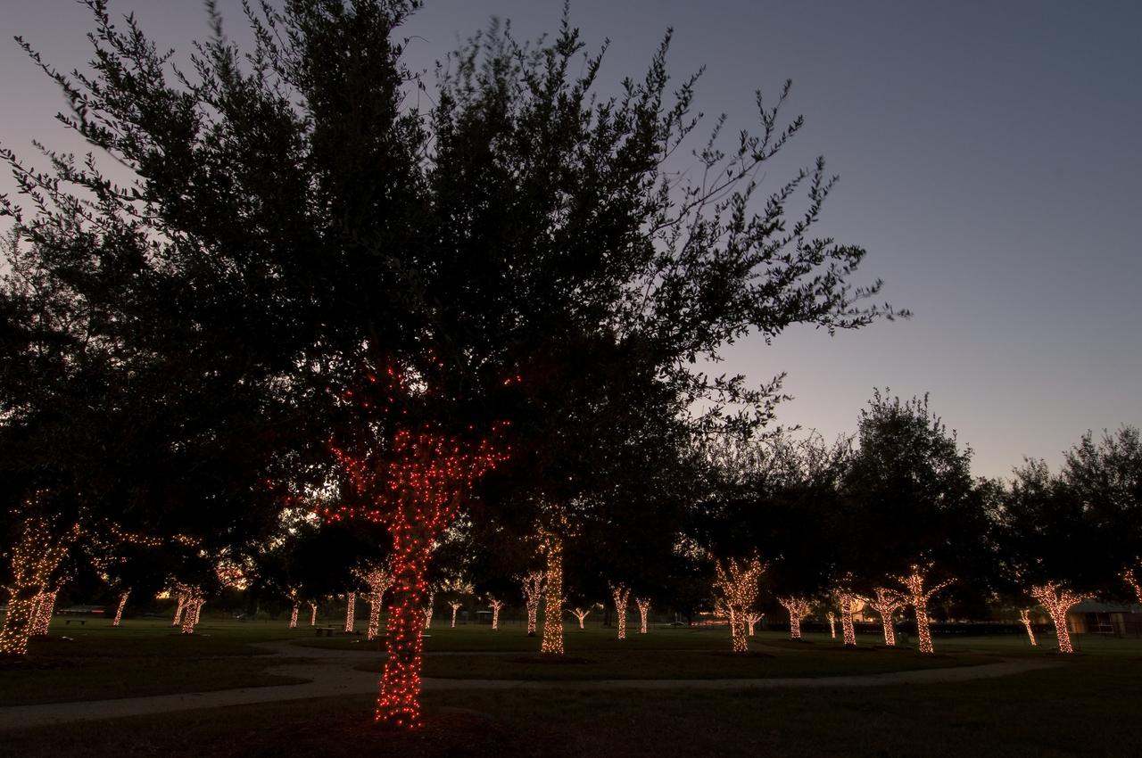
View of Christmas Lights on Memorial Tree Grove at dusk at entrance to JSC.
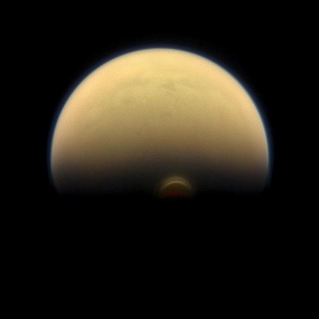
Slipping into shadow, the south polar vortex at Saturn's moon Titan still stands out against the orange and blue haze layers that are characteristic of Titan's atmosphere. Images like this, from NASA's Cassini spacecraft, lead scientists to conclude that the polar vortex clouds form at a much higher altitude -- where sunlight can still reach -- than the lower-altitude surrounding haze. This view looks towards the trailing hemisphere of Titan (3,200 miles or 5,150 kilometers across). North on Titan is up and rotated 17 degrees to the left. Images taken using red, green and blue spectral filters were combined to create this natural-color view. The image was taken with the Cassini spacecraft narrow-angle camera on July 30, 2013. The view was acquired at a distance of approximately 895,000 miles (1.441 million kilometers) from Titan. Image scale is 5 miles (9 kilometers) per pixel. http://photojournal.jpl.nasa.gov/catalog/PIA17177
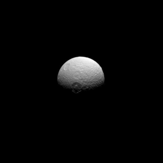
NASA Cassini spacecraft captured this image of Tethys, telling the story of a violent history marked by impacts. Seen here are the craters Melanthius near the center, Dolius above Melanthius, and Penelope upper left almost over the limb.
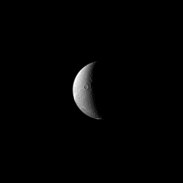
In this recent view of Dione, the Cassini spacecraft looks on as the moon slow rotation brings the terrain from day into night. Dione rotation period is 66 hours.
At dusk, the northern side of Building 4221 on Marshall Space Flight Center’s campus is silhouetted against blue skies.
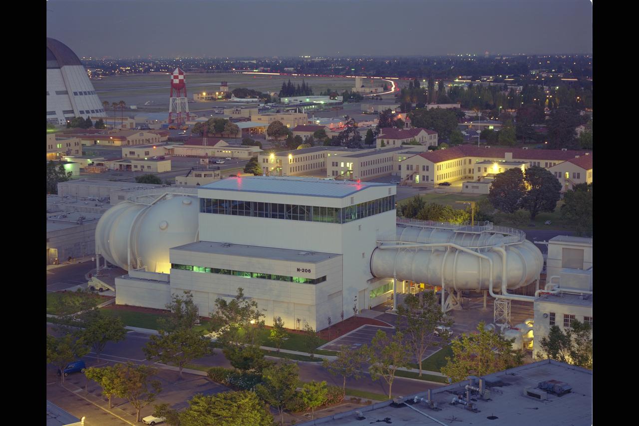
New renovated NASA Ames Research Center 12ft Pressure Wind Tunnel at dusk
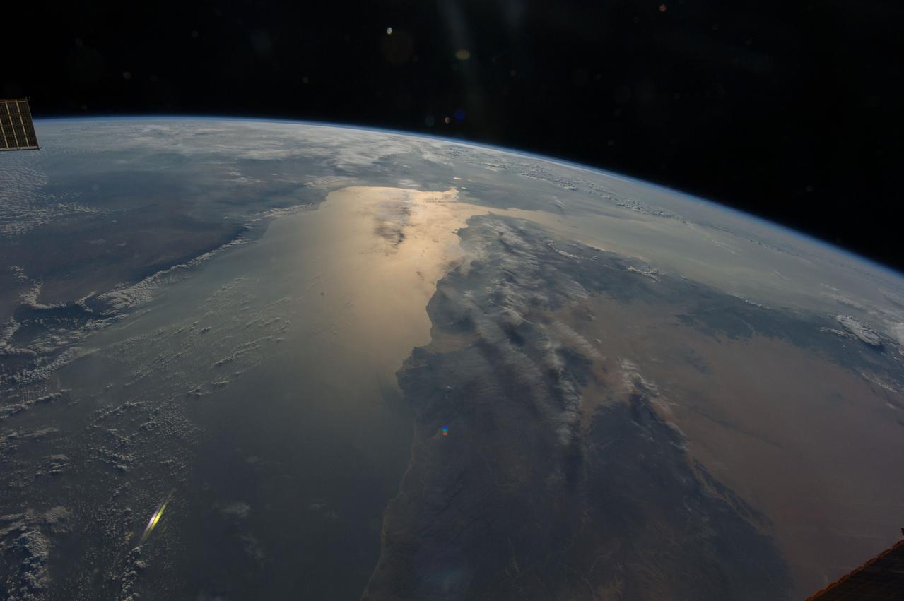
Earth observation taken during day pass by an Expedition 36 crew member on board the International Space Station (ISS). Per Twitter message: Dusk, as we traveled south of the tip of Africa.
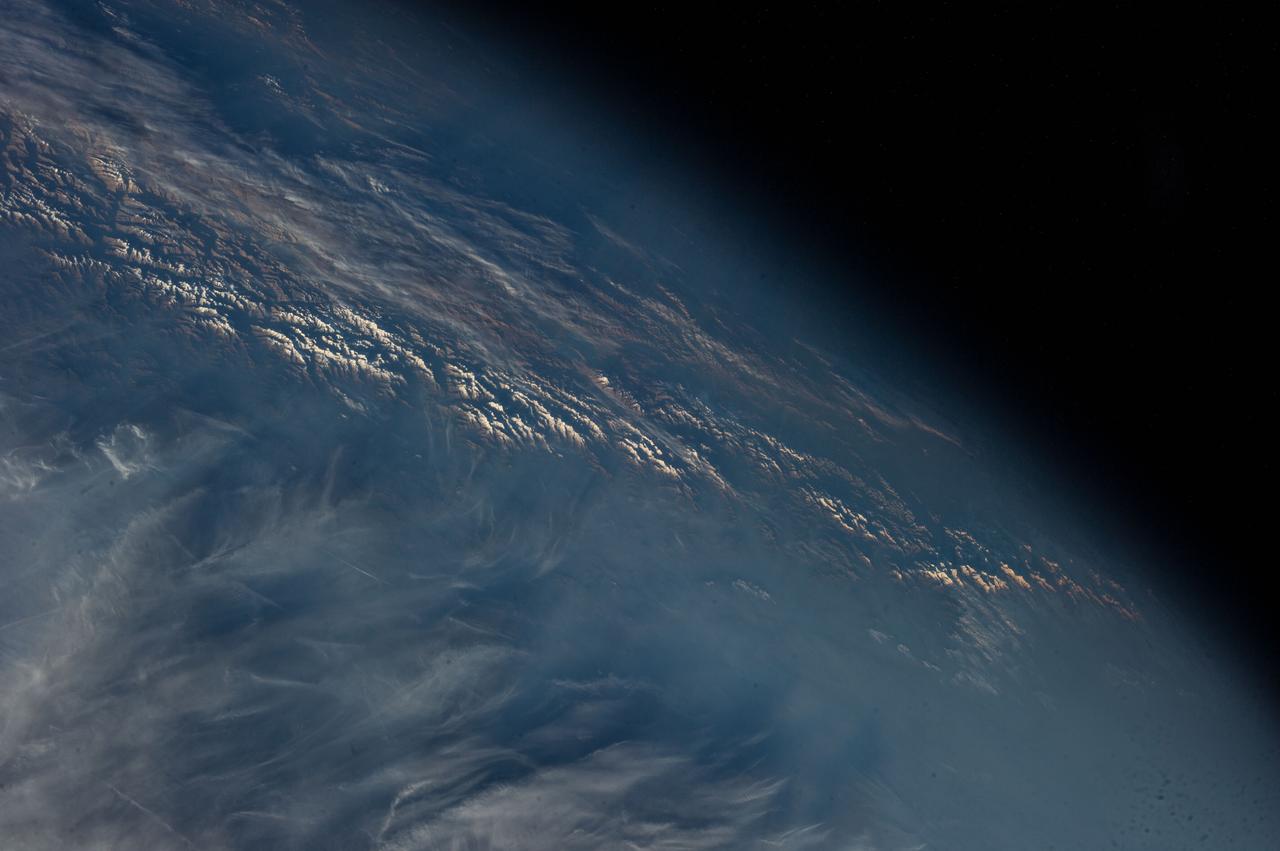
Earth observation taken during a day pass by an Expedition 37 crew member on board the International Space Station (ISS). Identified via Twitter message as dusk on the Himalayas.
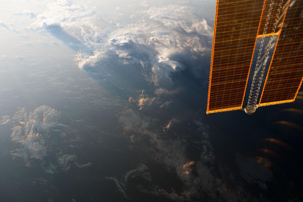
ISS042E021548 (12/03/2014) --- Voluminous clouds envelope the Earth at dusk in this image taken by the crew of the International Space station. An arm of the stations massive solar array frames the Earth observation.
iss042e031364 (12/08/2014) ---US Astronaut Terry Virts aboard the International Space Station caught this stunning image of the Red Sea and East Afirca at dusk 8 December 2014.
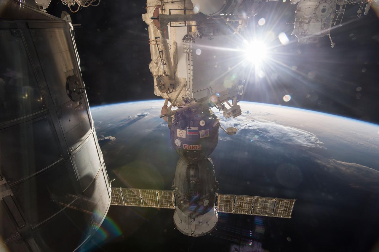
ISS043E157479 (04/29/2015) --- The Soyuz TMA-15M vehicle has been docked to the Rassvet module since it carried NASA astronaut Terry Virts, ESA (European Space Agency) astronaut Samantha Cristoforetti and Russian cosmonaut Anton Shkaplerov to the International Space Station in Nov. 2014. It will return them home after six months in orbit on May 13.

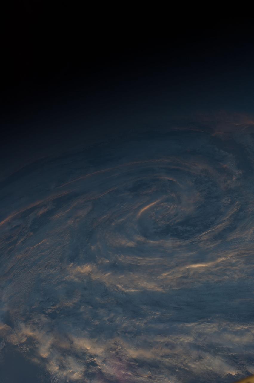
ISS047e025377 (03/28/2016) --- "Islands in the Sky" . Members of the International Space Station Expedition 47 crew took in the beauty of our planet on Mar. 3, 2016 as dusk falls over the oceans. NASA astronaut Jeff Williams took this majestic image.
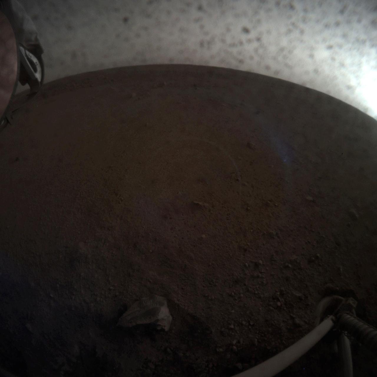
A fish-eye view of NASA's InSight lander deploying its first instrument onto the surface of Mars. InSight's robotic arm placed the seismometer on Dec. 19, 2018, around the time of dusk on Mars. These images were taken by the Instrument Context Camera (ICC), a fish-eye camera under the spacecraft's deck. Animation available at https://photojournal.jpl.nasa.gov/catalog/PIA22978
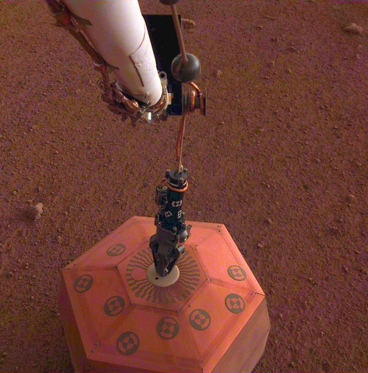
This set of images shows NASA's InSight lander deploying its first instrument onto the surface of Mars, completing a major mission milestone. InSight's robotic arm is white, with a black, handlike grapple at the end. The grapple is holding onto the copper-colored seismometer. The color-calibrated image was taken on Dec. 19, 2018, around dusk on Mars, with InSight's Instrument Deployment Camera (IDC), which is on the lander's robotic arm. Animation available at https://photojournal.jpl.nasa.gov/catalog/PIA22977
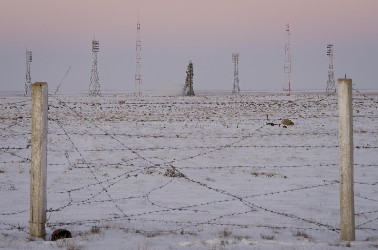
The Soyuz TMA-03M spacecraft is seen at dusk an hour before launch at the Baikonur Cosmodrome in Kazakhstan, Wednesday, Dec. 21, 2011. The crew of Expedition 30, NASA Flight Engineer Don Pettit, Soyuz Commander Oleg Konenko, ESA (European Space Agency) Andre Kuipers launched at 7:16pm local time to the International Space Station. Photo Credit: (NASA/Carla Cioffi)

The Soyuz TMA-03M spacecraft is seen at dusk an hour before launch at the Baikonur Cosmodrome in Kazakhstan, Wednesday, Dec. 21, 2011. The crew of Expedition 30, NASA Flight Engineer Don Pettit, Soyuz Commander Oleg Konenko, ESA (European Space Agency) Andre Kuipers launched at 7:16pm local time to the International Space Station. Photo Credit: (NASA/Carla Cioffi)
CAPE CANAVERAL, Fla. -- Dusk descends on the Freedom Star, one of NASA's solid rocket booster retrieval ships stationed in the Atlantic Ocean, to recover the right spent booster after it splashed down following space shuttle Discovery's final launch. The shuttle’s two solid rocket booster casings and associated flight hardware are recovered in the Atlantic Ocean after every launch by Freedom Star and Liberty Star. The boosters impact the Atlantic about seven minutes after liftoff and the retrieval ships are stationed about 10 miles from the impact area at the time of splashdown. After the spent segments are processed, they will be transported to Utah, where they will be refurbished and stored, if needed. Photo credit: NASA/Frank Michaux
This image captured by NASA 2001 Mars Odyssey spacecraft shows the region near the south polar cap called Angustus Labyrinthus, which is defined by the linear ridges. The Odyssey spacecraft orbit is near the day/night terminator, which means looking at the surface near dawn and dusk. This image was taken in the late afternoon and the low sun angle casts shadows behind the taller peaks. The shadows show the topography of the ridges, which is hard to see from above. Orbit Number: 67658 Latitude: -81.3907 Longitude: 296.204 Instrument: VIS Captured: 2017-03-15 21:34 https://photojournal.jpl.nasa.gov/catalog/PIA21661
Over the course of the Odyssey mission, the spacecraft has flown covering the surface at many different times of local day. Right now Odyssey is looking down along the day/night terminator, seeing dawn and dusk. One of the benefits from imaging at these times of day (and lower sun angles) is seeing shadows. This VIS image shows the sunrise shadow of the crater rim on the crater floor. Orbit Number: 66810 Latitude: -32.1248 Longitude: 132.667 Instrument: VIS Captured: 2017-01-05 01:05 http://photojournal.jpl.nasa.gov/catalog/PIA21317
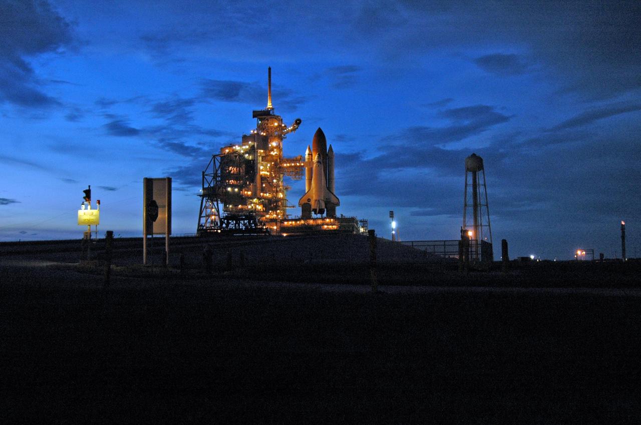
KENNEDY SPACE CENTER, FLA. - Launch Pad 39B and Space Shuttle Atlantis glow in the dusk after the morning launch was scrubbed due to a technical concern. Atlantis was scheduled to launch at 11:41 a.m. EDT Sept. 8 but was scrubbed due to an issue with a fuel cut-off sensor system inside the external fuel tank. This is one of several systems that protect the shuttle's main engines by triggering their shutdown if fuel runs unexpectedly low. This mission is the 116th space shuttle flight, the 27th flight for orbiter Atlantis, and the 19th U.S. flight to the International Space Station. STS-115 is scheduled to last 11 days with a planned landing at KSC. Photo credit: NASA/Ken Thornsley
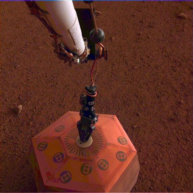
NASA's InSight lander placed its seismometer onto Mars on Dec. 19, 2018. This was the first time a seismometer had ever been placed onto the surface of another planet. The seismometer is the copper-colored object in this image, which was taken around Martian dusk. The seismometer, called Seismic Explorations for Interior Structure (SEIS), will measure seismic waves caused by marsquakes, meteorite strikes and other phenomena. Watching how these waves travel through Mars' interior will let scientists study how the planet's crust, mantle and core are layered. It will also reveal more about how all rocky bodies are formed, including Earth and its Moon. https://photojournal.jpl.nasa.gov/catalog/PIA22956
Main Gate, NASA Glenn Research Center, Cleveland, Ohio
CAPE CANAVERAL, Fla. – The mobile launcher, or ML, makes its way past the turn basin as dusk descends on NASA's Kennedy Space Center in Florida. The ML is nearing the end of its 4.2-mile trek from Launch Pad 39B to the park site near the Vehicle Assembly Building. Data on the ML collected from structural and functional engineering tests during its two-week stay on the pad will be used in the next phases of construction. The 355-foot-tall ML structure, which took about two years to construct, will be modified by NASA’s 21st Century Ground Systems Program to support NASA’s Space Launch System, the heavy-lift rocket that will launch astronauts into deep space on future exploration missions. For more information, visit http://www.nasa.gov/exploration/systems/sls. Photo credit: NASA/Cory Huston
ISS040-E-113700 (31 Aug. 2014) --- This panorama view, photographed by an Expedition 40 crew member on the International Space Station, shows tan-colored dust of a major dust storm obscuring the Persian Gulf and the its northern shoreline. Strong north winds often blow in summer, churning up dust from the entire length of the desert surfaces of the Tigris and Euphrates valleys (top left). Dust partly obscures the hundreds of kilometers of Iraq’s light-green agricultural lands along these rivers (left). A line of thunderstorms is being set off by the Zagros Mountains of Iran (right), with the setting sun casting long shadows from the thunderheads. Space station crews see sixteen sunrises and sunsets every day from low Earth orbit. Here the crew captured dusk in a darkening Iranian landscape (right).

On Mar. 6, 2019, SDO observed a long lunar transit - with a twist. The shadow of the Moon in SDO's images first touched the limb of the Sun at 2200 UTC (5pm EST) on Mar. 6, making its way across and finally left the solar disk at 0209 UTC on Mar. 7 (9:09 pm EST, Mar. 6). The moon's apparent reversal is caused by SDO first overtaking the moon in its orbit, then the moon catching up as SDO swings around Earth's dusk side. During the transit the Sun moves in the frame as the telescopes cool and flex in the lunar shadow. Note that the edge of the Moon is very sharp because it has no atmosphere. Movies available at https://photojournal.jpl.nasa.gov/catalog/PIA21905

CAPE CANAVERAL, Fla. -- Dusk falls on the Shuttle Landing Facility, or SLF, at NASA's Kennedy Space Center in Florida where space shuttle Endeavour and the shuttle carrier aircraft are positioned under the mate/demate device. A sling will lift the shuttle away from the shuttle carrier aircraft, or SCA, underneath. The SCA carried the shuttle piggyback from California, where Endeavour landed Nov. 30 to end the STS-126 mission. When Endeavour is on the ground, it will be towed via the two-mile tow-way from the SLF by a diesel-powered tractor to the Orbiter Processing Facility where it will begin preparations for its next mission, STS-127, targeted for May 2009. Photo credit: NASA/Jack Pfaller

CAPE CANAVERAL, Fla. -- This view at dusk from the stern of Freedom Star, one of NASA's solid rocket booster retrieval ships, shows the Pegasus Barge carrying the Space Shuttle Program's last external fuel tank, ET-122, as it is transported to NASA's Kennedy Space Center in Florida. The tank will travel 900 miles by sea before being offloaded and moved to Kennedy's Vehicle Assembly Building where it will be integrated to space shuttle Endeavour for the STS-134 mission to the International Space Station. The tank, which is the largest element of the space shuttle stack, was damaged during Hurricane Katrina in August 2005 and restored to flight configuration by Lockheed Martin Space Systems Company employees. STS-134, targeted to launch Feb. 2011, currently is scheduled to be the last mission in the Space Shuttle Program. Photo credit: NASA/Kim Shiflett
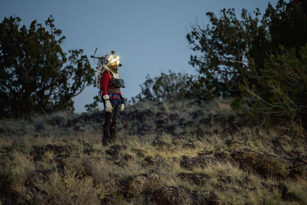
NASA astronaut Andre Douglas views the lunar-like landscape at dusk while wearing the Joint AR (Joint Augmented Reality Visual Informatics System) display during an advanced technology run in the San Francisco Volcanic Field in Northern Arizona on May 21, 2024. The suit display features include navigation, photo capture, graphical format of consumables, procedure viewing, mission control updates, and other augmented reality cues and graphics. The team successfully tested navigation displays using data from four different data streams: GPS (Global Positioning System)/IMU (Inertial Measurement Unit), camera/IMU, LiDAR (Light Detection and Ranging), and static maps. Technology like this may be used for future Artemis missions to augment mission control communication and help guide crew back to the lunar lander. Credit: NASA/Josh Valcarcel
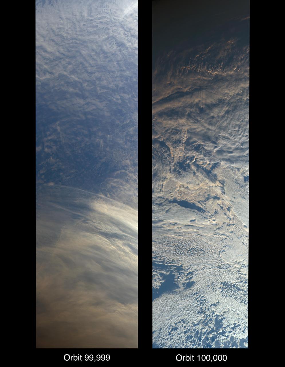
On Oct. 6, 2018, NASA's Terra satellite became one of a handful of NASA satellite ever to complete 100,000 orbits. Launched in 1999, Terra and its five scientific instruments were originally slated to last six years. More than 18 years later, the Multi-angle Imaging SpectroRadiometer (MISR), built by NASA's Jet Propulsion Laboratory in Pasadena, California, and other instruments on Terra are still collecting data and are expected to continue into the 2020s, limited only by the amount of fuel in the spacecraft. MISR carries nine cameras that view the sunlit Earth simultaneously at widely spaced angles, providing global coverage with high spatial detail. The left image shows dusk falling over snowy Queen Maud Land, Antarctica, at the end of orbit 99,999, as captured by MISR's 70-degree backward-looking camera. On the right is MISR's first view from orbit 100,000, taken by its 70-degree forward-looking camera as sunrise illuminated clouds over the Kara Sea, north of Siberia. Over the years, researchers have used MISR's observations to construct a variety of global data sets that have advanced our understanding of Earth. These include the heights of clouds and wildfire smoke, the amounts of dangerous pollutants in the atmosphere, the movements of global wind systems, and the health of vegetation. The instrument remains as healthy as it was in 1999. https://photojournal.jpl.nasa.gov/catalog/PIA22836
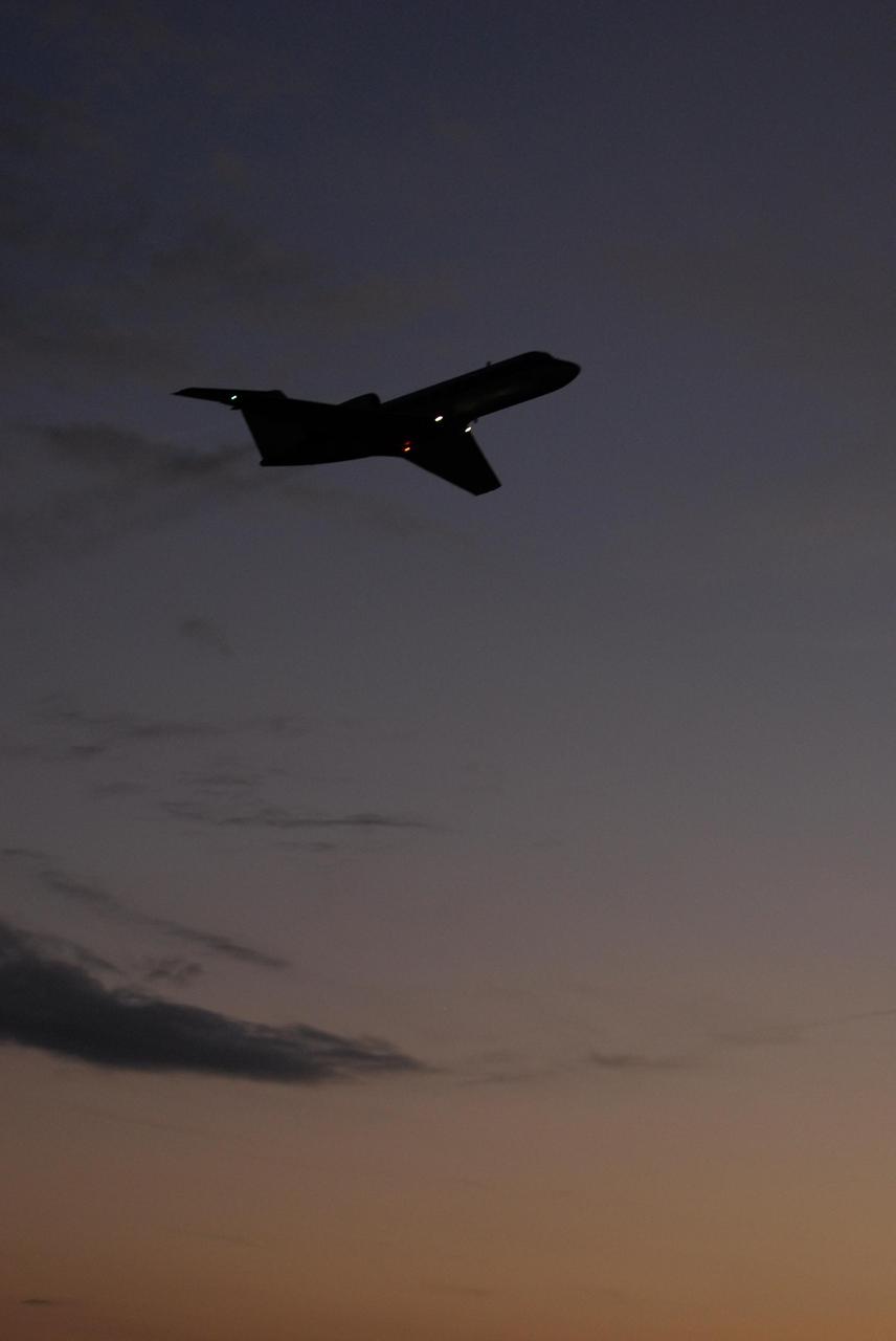
KENNEDY SPACE CENTER, FLA. -- A shuttle training aircraft, or STA, takes off from Kennedy Space Center's Shuttle Landing Facility at dusk. The STA is being used for practice flights by space shuttle Atlantis STS-122 Commander Steve Frick and Pilot Alan Poindexter. The STA is a Grumman American Aviation-built Gulf Stream II jet that was modified to simulate an orbiter's cockpit, motion and visual cues, and handling qualities. In flight, the STA duplicates the orbiter's atmospheric descent trajectory from approximately 35,000 feet altitude to landing on a runway. Because the orbiter is unpowered during re-entry and landing, its high-speed glide must be perfectly executed the first time. The training is part of terminal countdown demonstration test, or TCDT, activities. The TCDT provides astronauts and ground crews with equipment familiarization, emergency egress training and a simulated launch countdown. On mission STS-122, Atlantis will deliver the European Space Agency's Columbus module to the International Space Station. Columbus is a multifunctional, pressurized laboratory that will be permanently attached to U.S. Node 2, called Harmony, and will expand the research facilities aboard the station. Launch is targeted for Dec. 6. Photo credit: NASA/Kim Shiflett
KENNEDY SPACE CENTER, FLA. -- A shuttle training aircraft, or STA, sits on the tarmac at Kennedy Space Center's Shuttle Landing Facility at dusk, ready for practice flights by space shuttle Atlantis STS-122 Commander Steve Frick and Pilot Alan Poindexter. The STA is a Grumman American Aviation-built Gulf Stream II jet that was modified to simulate an orbiter's cockpit, motion and visual cues, and handling qualities. In flight, the STA duplicates the orbiter's atmospheric descent trajectory from approximately 35,000 feet altitude to landing on a runway. Because the orbiter is unpowered during re-entry and landing, its high-speed glide must be perfectly executed the first time. The training is part of terminal countdown demonstration test, or TCDT, activities. The TCDT provides astronauts and ground crews with equipment familiarization, emergency egress training and a simulated launch countdown. On mission STS-122, Atlantis will deliver the European Space Agency's Columbus module to the International Space Station. Columbus is a multifunctional, pressurized laboratory that will be permanently attached to U.S. Node 2, called Harmony, and will expand the research facilities aboard the station. Launch is targeted for Dec. 6. Photo credit: NASA/Kim Shiflett

KENNEDY SPACE CENTER, FLA. -- A shuttle training aircraft, or STA, prepares for takeoff from Kennedy Space Center's Shuttle Landing Facility at dusk. The STA is being used for practice flights by space shuttle Atlantis STS-122 Commander Steve Frick and Pilot Alan Poindexter. The STA is a Grumman American Aviation-built Gulf Stream II jet that was modified to simulate an orbiter's cockpit, motion and visual cues, and handling qualities. In flight, the STA duplicates the orbiter's atmospheric descent trajectory from approximately 35,000 feet altitude to landing on a runway. Because the orbiter is unpowered during re-entry and landing, its high-speed glide must be perfectly executed the first time. The training is part of terminal countdown demonstration test, or TCDT, activities. The TCDT provides astronauts and ground crews with equipment familiarization, emergency egress training and a simulated launch countdown. On mission STS-122, Atlantis will deliver the European Space Agency's Columbus module to the International Space Station. Columbus is a multifunctional, pressurized laboratory that will be permanently attached to U.S. Node 2, called Harmony, and will expand the research facilities aboard the station. Launch is targeted for Dec. 6. Photo credit: NASA/Kim Shiflett
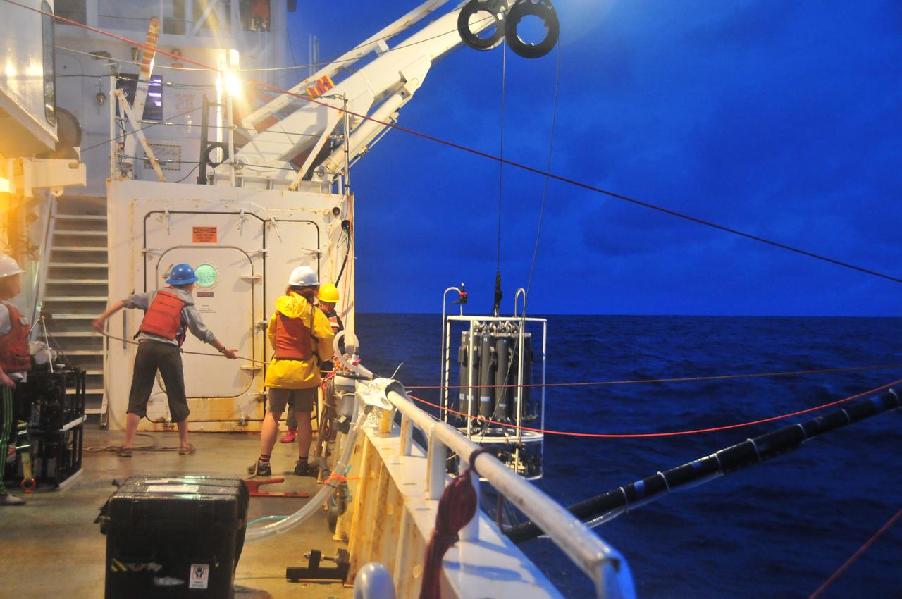
Instruments Overboard On July 26, 2014, scientists worked past dusk to prepare and deploy the optical instruments and ocean water sensors during NASA's SABOR experiment. NASA's Ship-Aircraft Bio-Optical Research (SABOR) experiment is a coordinated ship and aircraft observation campaign off the Atlantic coast of the United States, an effort to advance space-based capabilities for monitoring microscopic plants that form the base of the marine food chain. Read more: <a href="http://1.usa.gov/WWRVzj" rel="nofollow">1.usa.gov/WWRVzj</a> Credit: NASA/SABOR/Wayne Slade, Sequoia Scientific . <b><a href="http://www.nasa.gov/audience/formedia/features/MP_Photo_Guidelines.html" rel="nofollow">NASA image use policy.</a></b> <b><a href="http://www.nasa.gov/centers/goddard/home/index.html" rel="nofollow">NASA Goddard Space Flight Center</a></b> enables NASA’s mission through four scientific endeavors: Earth Science, Heliophysics, Solar System Exploration, and Astrophysics. Goddard plays a leading role in NASA’s accomplishments by contributing compelling scientific knowledge to advance the Agency’s mission. <b>Follow us on <a href="http://twitter.com/NASAGoddardPix" rel="nofollow">Twitter</a></b> <b>Like us on <a href="http://www.facebook.com/pages/Greenbelt-MD/NASA-Goddard/395013845897?ref=tsd" rel="nofollow">Facebook</a></b> <b>Find us on <a href="http://instagram.com/nasagoddard?vm=grid" rel="nofollow">Instagram</a></b>
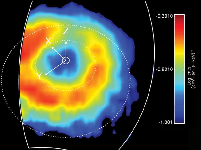
Like Earth, Saturn has an invisible ring of energetic ions trapped in its magnetic field. This feature is known as a "ring current." This ring current has been imaged with a special camera on Cassini sensitive to energetic neutral atoms. This is a false color map of the intensity of the energetic neutral atoms emitted from the ring current through a processed called charged exchange. In this process a trapped energetic ion steals and electron from cold gas atoms and becomes neutral and escapes the magnetic field. The Cassini Magnetospheric Imaging Instrument's ion and neutral camera records the intensity of the escaping particles, which provides a map of the ring current. In this image, the colors represent the intensity of the neutral emission, which is a reflection of the trapped ions. This "ring" is much farther from Saturn (roughly five times farther) than Saturn's famous icy rings. Red in the image represents the higher intensity of the particles, while blue is less intense. Saturn's ring current had not been mapped before on a global scale, only "snippets" or areas were mapped previously but not in this detail. This instrument allows scientists to produce movies (see PIA10083) that show how this ring changes over time. These movies reveal a dynamic system, which is usually not as uniform as depicted in this image. The ring current is doughnut shaped but in some instances it appears as if someone took a bite out of it. This image was obtained on March 19, 2007, at a latitude of about 54.5 degrees and radial distance 1.5 million kilometres (920,000 miles). Saturn is at the center, and the dotted circles represent the orbits of the moon's Rhea and Titan. The Z axis points parallel to Saturn's spin axis, the X axis points roughly sunward in the sun-spin axis plane, and the Y axis completes the system, pointing roughly toward dusk. The ion and neutral camera's field of view is marked by the white line and accounts for the cut-off of the image on the left. The image is an average of the activity over a (roughly) 3-hour period. http://photojournal.jpl.nasa.gov/catalog/PIA10094
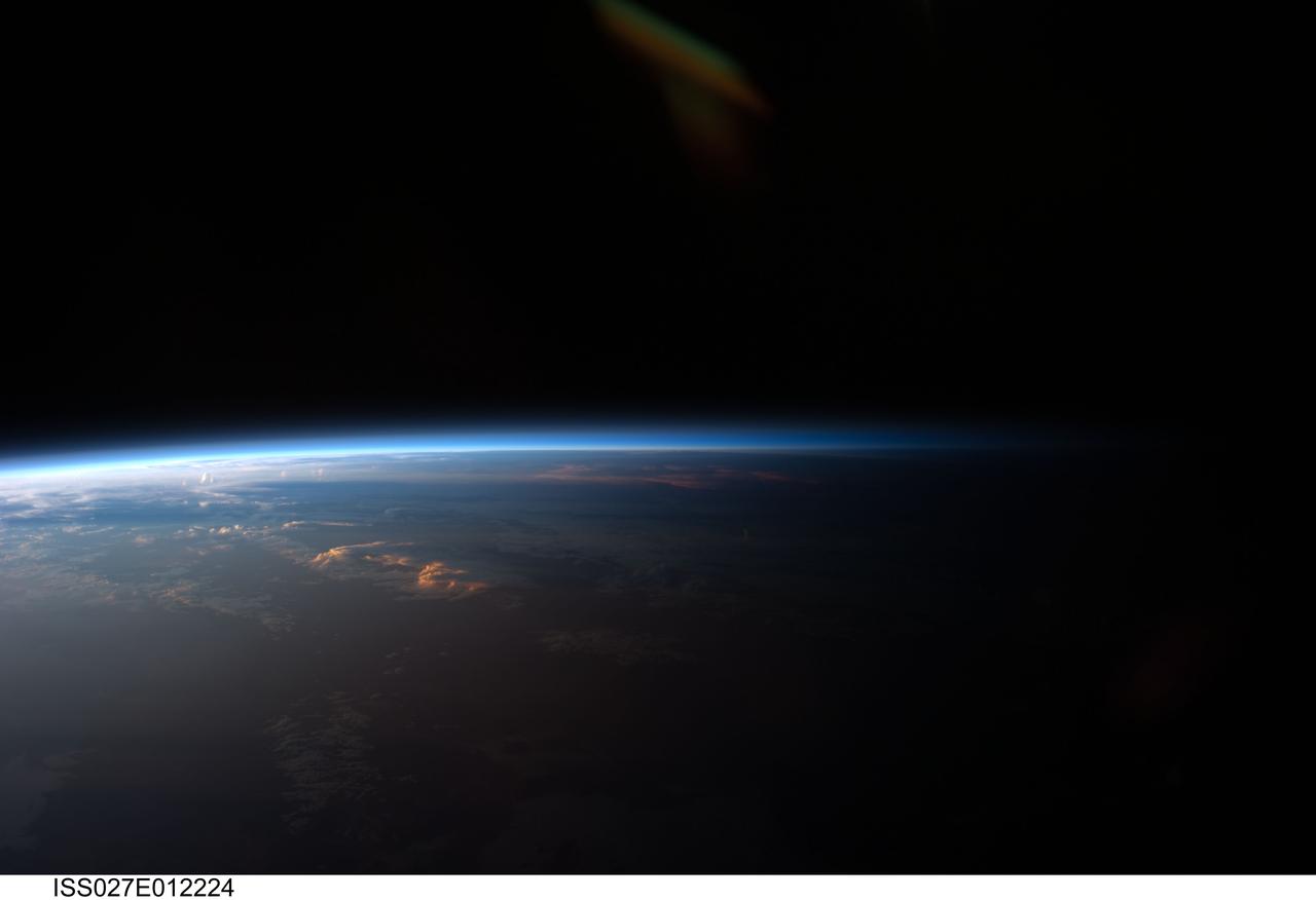
ISS027-E-012224 (12 April 2011) --- Sunset over western South America is featured in this image photographed by an Expedition 27 crew member on the International Space Station. Crew members onboard the space station see, on average, sixteen sunrises and sunsets during a 24-hour orbital period. Each changeover between day and night on the ground is marked by the terminator, or line separating the sunlit side of Earth from the side in darkness. While the terminator is conceptualized as a hard boundary?and is frequently presented as such in graphics and visualizations?in reality the boundary between light and dark is diffuse due to scattering of light by Earth?s atmosphere. This zone of diffuse lighting is experienced as dusk or twilight on the ground ? while the sun is no longer visible, some illumination is still present due to light scattering over the local horizon. The terminator is visible in this photograph trending across the image from lower left to upper right. This panoramic view across central South America, looking towards the northeast, was acquired at approximately 7:37 p.m. local time. Layers of Earth?s atmosphere, colored bright white to deep blue, are visible extending across the horizon (or limb). The highest cloud tops have a reddish glow from the direct light of the setting sun while lower clouds are in twilight. The Salar de Coipasa, a large salt lake in Bolivia, is dimly visible on the night side of the terminator. The salar provides a geographic reference point that allows the location and viewing orientation of the image to be determined.

This image provides the clearest ever view of galaxy NGC 949, which lies over 30 million light-years away in the constellation of Triangulum. The galaxy has an unusual shape, made more obscure due to its inclination. From our point of view, it is difficult to discern exactly what type of galaxy NGC 949 is, but it is certainly a disc galaxy of some kind, most likely a spiral. NGC 949 was first discovered by Sir William Herschel on 21 September 1786, using an 18.7-inch reflecting telescope. The galaxy was one of about 3000 objects Herschel catalogued as "nebulae" during an intense and systematic deep sky survey, the results of which eventually formed the bulk of the New General Catalogue (NGC). Taken with Hubble’s Advanced Camera for Surveys (ACS), this new image shows extraordinary detail. This detail allows us to see a strange asymmetric alignment in the dark lanes of dust that snake across the galaxy. The top-right half of the galaxy appears considerably more marbled with dust in this image; a curious observation explained by stars tending to favour locations towards the centre of a galaxy, and dust preferring almost invariably to reside along the galactic plane. When a galaxy is inclined as NGC 949 is, some regions — in this case the top-right — are tipped towards us and the light from the stars we see in these regions has had to travel through more dust. This causes the light to appear redder — the result of the same process that gives the sun’s light a red hue at dusk — or else disappear entirely, making the dust appear more prominent on that side of the galaxy. In the part tipped away from us, the light from the stars has had to pass through much less dust to reach us, so it appears brighter, and the dust is much less prominent. Were it possible to view NGC 949 from the opposite side, the apparent alignment of the dust would be reversed. The scientific advantages of this effect were recently displayed in suitably stunning style in the M31 PHAT mosa
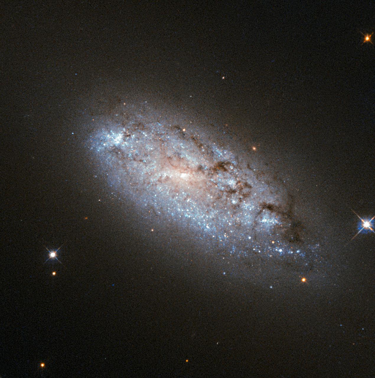
This image provides the clearest ever view of galaxy NGC 949, which lies over 30 million light-years away in the constellation of Triangulum. The galaxy has an unusual shape, made more obscure due to its inclination. From our point of view, it is difficult to discern exactly what type of galaxy NGC 949 is, but it is certainly a disk galaxy of some kind, most likely a spiral. NGC 949 was first discovered by Sir William Herschel on September 21, 1786, using an 18.7-inch reflecting telescope. The galaxy was one of about 3,000 objects Herschel cataloged as "nebulae" during an intense and systematic deep sky survey, the results of which eventually formed the bulk of the New General Catalogue (NGC). Taken with Hubble’s Advanced Camera for Surveys (ACS), this image shows extraordinary detail. This detail allows us to see a strange asymmetric alignment in the dark lanes of dust that snake across the galaxy. The top-right half of the galaxy appears considerably more marbled with dust in this image; a curious observation explained by stars tending to favor locations towards the center of a galaxy, and dust preferring almost invariably to reside along the galactic plane. When a galaxy is inclined as NGC 949 is, some regions — in this case the top-right — are tipped toward us and the light from the stars we see in these regions has had to travel through more dust. This causes the light to appear redder — the result of the same process that gives the sun’s light a red hue at dusk — or else disappear entirely, making the dust appear more prominent on that side of the galaxy. In the part tipped away from us, the light from the stars has had to pass through much less dust to reach us, so it appears brighter, and the dust is much less prominent. Were it possible to view NGC 949 from the opposite side, the apparent alignment of the dust would be reversed. The scientific advantages of this effect were recently displayed in suitably stunning style in the M31 PHAT mosaic, which allowed astronomers to produce a partial three-dimensional dust map of M31 four times clearer than any previously attempted. Credit: ESA/Hubble & NASA <b><a href="http://www.nasa.gov/audience/formedia/features/MP_Photo_Guidelines.html" rel="nofollow">NASA image use policy.</a></b> <b><a href="http://www.nasa.gov/centers/goddard/home/index.html" rel="nofollow">NASA Goddard Space Flight Center</a></b> enables NASA’s mission through four scientific endeavors: Earth Science, Heliophysics, Solar System Exploration, and Astrophysics. Goddard plays a leading role in NASA’s accomplishments by contributing compelling scientific knowledge to advance the Agency’s mission. <b>Follow us on <a href="http://twitter.com/NASAGoddardPix" rel="nofollow">Twitter</a></b> <b>Like us on <a href="http://www.facebook.com/pages/Greenbelt-MD/NASA-Goddard/395013845897?ref=tsd" rel="nofollow">Facebook</a></b> <b>Find us on <a href="http://instagrid.me/nasagoddard/?vm=grid" rel="nofollow">Instagram</a></b>
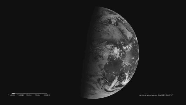
Images acquired December 21, 2010 - September 20, 2011. To download the high res and learn more go to: <a href="http://earthobservatory.nasa.gov/IOTD/view.php?id=52248" rel="nofollow">earthobservatory.nasa.gov/IOTD/view.php?id=52248</a> One of the most frequently misunderstood concepts in science is the reason for Earth’s seasons. As we experience the September equinox today—anyone try to balance an egg yet?—we thought we’d offer a space-based view of what’s going on. Around 6 a.m. local time each day, the Sun, Earth, and any geosynchronous satellite form a right angle, affording a nadir (straight down) view of the terminator, where the shadows of nightfall meet the sunlight of dusk and dawn. The shape of this line between night and day varies with the seasons, which means different lengths of days and differing amounts of warming sunshine. (The line is actually a curve because the Earth is round, but satellite images only show it in two-dimensions.) The Spinning Enhanced Visible and Infrared Imager (SEVIRI) on EUMETSAT's Meteosat-9 captured these four views of the day-night terminator on December 21, 2010, and March 20, June 21, and September 20, 2011. Each image was taken at 6:12 a.m. local time. On March 20 and September 20, the terminator is a straight north-south line, and the Sun is said to sit directly above the equator. On December 21, the Sun resides directly over the Tropic of Capricorn when viewed from the ground, and sunlight spreads over more of the Southern Hemisphere. On June 21, the Sun sits above the Tropic of Cancer, spreading more sunlight in the north and turning the tables on the south. The bulge of our spherical Earth blocks sunlight from the far hemisphere at the solstices; that same curvature allows the Sun’s rays to spread over more area near the top and bottom of the globe. Of course, it is not the Sun that is moving north or south through the seasons, but a change in the orientation and angles between the Earth and its nearest star. The axis of the Earth is tilted 23.5 degrees relative to the Sun and the ecliptic plane. The axis is tilted away from the Sun at the December solstice and toward the Sun at the June solstice, spreading more and less light on each hemisphere. At the equinoxes, the tilt is at a right angle to the Sun and the light is spread evenly. The equinox and changing of the seasons occurs on September 23, 2011 at 9:05 a.m. Universal Time. (Our September image above is a few days early.) Equinox means "equal night" in Latin, capturing the idea that daytime and nighttime are equal lengths everywhere on the planet. That is true of the Sun's presence above the horizon, though it does not account for twilight, when the Sun's rays extend from beyond the horizon to illuminate our gas-filled atmosphere. <b>NASA images and animation by Robert Simmon, using data ©2010 EUMETSAT. Caption by Mike Carlowicz.</b> Instrument: Meteosat Credit: <b><a href="http://www.earthobservatory.nasa.gov/" rel="nofollow"> NASA Earth Observatory</a></b> <b><a href="http://www.nasa.gov/audience/formedia/features/MP_Photo_Guidelines.html" rel="nofollow">NASA image use policy.</a></b> <b><a href="http://www.nasa.gov/centers/goddard/home/index.html" rel="nofollow">NASA Goddard Space Flight Center</a></b> enables NASA’s mission through four scientific endeavors: Earth Science, Heliophysics, Solar System Exploration, and Astrophysics. Goddard plays a leading role in NASA’s accomplishments by contributing compelling scientific knowledge to advance the Agency’s mission. <b>Follow us on <a href="http://twitter.com/NASAGoddardPix" rel="nofollow">Twitter</a></b> <b>Like us on <a href="http://www.facebook.com/pages/Greenbelt-MD/NASA-Goddard/395013845897?ref=tsd" rel="nofollow">Facebook</a></b> <b>Find us on <a href="http://instagrid.me/nasagoddard/?vm=grid" rel="nofollow">Instagram</a></b>

Images acquired December 21, 2010 - September 20, 2011. To view a HD animation of this go to: <a href="http://www.flickr.com/photos/gsfc/6175313242/in/photostream/">www.flickr.com/photos/gsfc/6175313242/in/photostream/</a> To download the high res and learn more go to: <a href="http://earthobservatory.nasa.gov/IOTD/view.php?id=52248" rel="nofollow">earthobservatory.nasa.gov/IOTD/view.php?id=52248</a> One of the most frequently misunderstood concepts in science is the reason for Earth’s seasons. As we experience the September equinox today—anyone try to balance an egg yet?—we thought we’d offer a space-based view of what’s going on. Around 6 a.m. local time each day, the Sun, Earth, and any geosynchronous satellite form a right angle, affording a nadir (straight down) view of the terminator, where the shadows of nightfall meet the sunlight of dusk and dawn. The shape of this line between night and day varies with the seasons, which means different lengths of days and differing amounts of warming sunshine. (The line is actually a curve because the Earth is round, but satellite images only show it in two-dimensions.) The Spinning Enhanced Visible and Infrared Imager (SEVIRI) on EUMETSAT's Meteosat-9 captured these four views of the day-night terminator on December 21, 2010, and March 20, June 21, and September 20, 2011. Each image was taken at 6:12 a.m. local time. On March 20 and September 20, the terminator is a straight north-south line, and the Sun is said to sit directly above the equator. On December 21, the Sun resides directly over the Tropic of Capricorn when viewed from the ground, and sunlight spreads over more of the Southern Hemisphere. On June 21, the Sun sits above the Tropic of Cancer, spreading more sunlight in the north and turning the tables on the south. The bulge of our spherical Earth blocks sunlight from the far hemisphere at the solstices; that same curvature allows the Sun’s rays to spread over more area near the top and bottom of the globe. Of course, it is not the Sun that is moving north or south through the seasons, but a change in the orientation and angles between the Earth and its nearest star. The axis of the Earth is tilted 23.5 degrees relative to the Sun and the ecliptic plane. The axis is tilted away from the Sun at the December solstice and toward the Sun at the June solstice, spreading more and less light on each hemisphere. At the equinoxes, the tilt is at a right angle to the Sun and the light is spread evenly. The equinox and changing of the seasons occurs on September 23, 2011 at 9:05 a.m. Universal Time. (Our September image above is a few days early.) Equinox means "equal night" in Latin, capturing the idea that daytime and nighttime are equal lengths everywhere on the planet. That is true of the Sun's presence above the horizon, though it does not account for twilight, when the Sun's rays extend from beyond the horizon to illuminate our gas-filled atmosphere. NASA images and animation by Robert Simmon, using data ©2010 EUMETSAT. Caption by Mike Carlowicz. Instrument: Meteosat Credit: <b><a href="http://www.earthobservatory.nasa.gov/" rel="nofollow"> NASA Earth Observatory</a></b> <b><a href="http://www.nasa.gov/audience/formedia/features/MP_Photo_Guidelines.html" rel="nofollow">NASA image use policy.</a></b> <b><a href="http://www.nasa.gov/centers/goddard/home/index.html" rel="nofollow">NASA Goddard Space Flight Center</a></b> enables NASA’s mission through four scientific endeavors: Earth Science, Heliophysics, Solar System Exploration, and Astrophysics. Goddard plays a leading role in NASA’s accomplishments by contributing compelling scientific knowledge to advance the Agency’s mission. <b>Follow us on <a href="http://twitter.com/NASAGoddardPix" rel="nofollow">Twitter</a></b> <b>Like us on <a href="http://www.facebook.com/pages/Greenbelt-MD/NASA-Goddard/395013845897?ref=tsd" rel="nofollow">Facebook</a></b> <b>Find us on <a href="http://instagrid.me/nasagoddard/?vm=grid" rel="nofollow">Instagram</a></b>