
This image from NASA Spitzer Space Telescope shows a computer simulation of the planet HD 80606b from an observer located at a point in space lying between the Earth and the HD 80606 system.
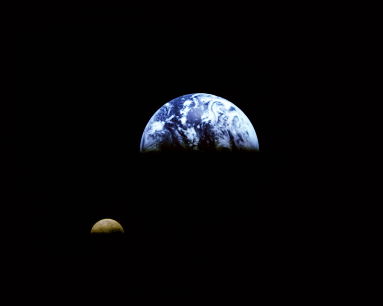
Eight days after its encounter with the Earth, the Galileo spacecraft was able to look back and capture this remarkable view of the Moon in orbit about the Earth, taken from a distance of about 6.2 million kilometers (3.9 million miles). The picture was constructed from images taken through the violet, red, and 1.0-micron infrared filters. The Moon is in the foreground, moving from left to right. The brightly-colored Earth contrasts strongly with the Moon, which reflects only about one-third as much sunlight as the Earth. Contrast and color have been computer-enhanced for both objects to improve visibility. Antarctica is visible through clouds (bottom). The Moon's far side is seen; the shadowy indentation in the dawn terminator is the south-Pole/Aitken Basin, one of the largest and oldest lunar impact features. Alternate Jet Propulsion Laboratory (JPL) number is P-41508. View appears in the Space News Roundup v32 n1 p1, 01-11-93.

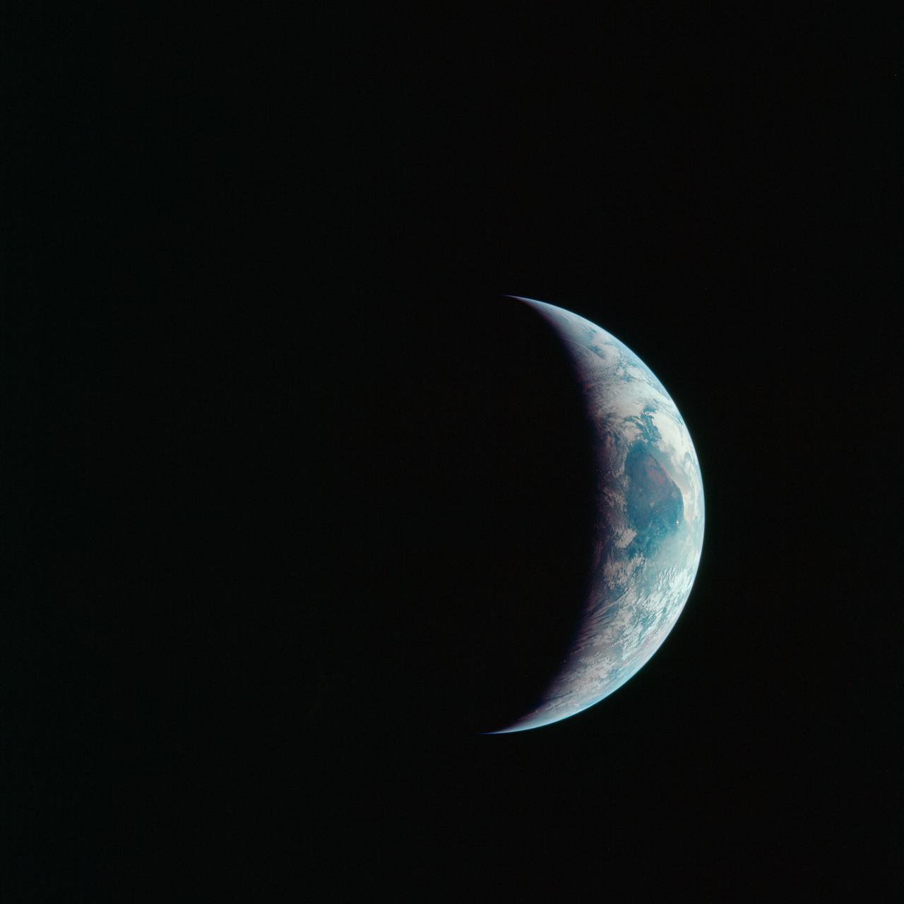
AS16-118-18885 (16 April 1972) --- A good view of Earth photographed about one and one-half hours after trans-lunar injection on April 16, 1972. Although there is much cloud cover, the United States in large part, most of Mexico and some parts of Central America are clearly visible. Note Lake Michigan and Lake Superior and the Bahama Banks (see different shade of blue below Florida). Just beginning man's fifth lunar landing mission were astronauts John W. Young, commander; Thomas K. Mattingly, II, command module pilot and Charles M. Duke Jr., lunar module pilot. While astronauts Young and Duke descended in the Lunar Module (LM) "Orion" to explore the Descartes highlands region of the moon, astronaut Mattingly remained with the Command and Service Modules (CSM) "Casper" in lunar orbit.

AS16-118-18880 (16 April 1972) --- A good view of Earth photographed about one hour after trans-lunar injection on April 16, 1972. Although there is much cloud cover, the United States in large part, most of Mexico and some of Central America are clearly visible. Note the Great Lakes (Michigan and Superior) and the Bahama Banks (note different shade of blue below Florida). While astronauts John W. Young, commander, and Charles M. Duke Jr., lunar module pilot, descended in the Lunar Module (LM) "Orion" to explore the Descartes highlands region of the moon, astronaut Thomas K. (Ken) Mattingly II, command module pilot, remained with the Command and Service Modules (CSM) "Casper" in lunar orbit.

AS17-148-22727 (7 Dec. 1972) --- This view of Earth was seen by the Apollo 17 crew as they traveled toward the moon on their NASA lunar landing mission. This outstanding trans-lunar coast photograph extends from the Mediterranean Sea area to the Antarctica south polar ice cap. This is the first time the Apollo trajectory made it possible to photograph the south polar ice cap. Note the heavy cloud cover in the Southern Hemisphere. Almost the entire coastline of Africa is clearly visible. The Arabian Peninsula can be seen at the northeastern edge of Africa. The large island off the coast of Africa is the Malagasy Republic. The Asian mainland is on the horizon toward the northeast. The Apollo 17 crew consisted of astronauts Eugene A. Cernan, mission commander; Ronald E. Evans, command module pilot; and Harrison H. Schmitt, lunar module pilot. While astronauts Cernan and Schmitt descended in the Lunar Module (LM) to explore the moon, astronaut Evans remained with the Command and Service Modules (CSM) in lunar orbit.
S62-01287 (21 July 1961) --- Earth observation take during the Mercury-Redstone 4 (MR-4) spaceflight. Photo credit: NASA
AS12-50-7362 (14 Nov. 1969) --- A view of one-third of Earth, with Australia on the horizon, as photographed by the three-man crew of Apollo 12. The Command and Service Modules, mated to the Lunar Module (yet to be removed and transpositioned for landing) were en route to the moon for man's second mission there. Onboard the spacecraft were astronauts Charles Conrad Jr., Richard F. Gordon Jr. and Alan L. Bean. Photo credit: NASA
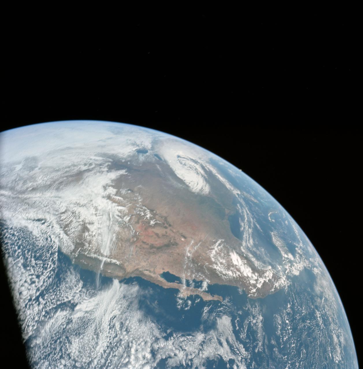
AS17-148-22742 (7-19 Dec. 1972) --- Most of Australia (center) and part of Antarctica are visible in this photo of a three-quarters Earth, recorded with a 70mm handheld Hasselblad camera using a 250mm lens. The three astronauts aboard the Command and Service Modules (CSM) were in the trans-lunar coast phase of the journey when one of them snapped this shot. While astronauts Eugene A. Cernan commander, and Harrison H. Schmitt, lunar module pilot, descended in the Lunar Module (LM) "Challenger" to explore the Taurus-Littrow region of the moon, astronaut Ronald E. Evans, command module pilot, remained with the CSM "America" in lunar orbit.

AS10-34-5026 (18-26 May 1969) --- An Apollo 10 photograph of Earth taken from 100,000 miles away. Visible are many areas of Europe and Africa. Among the features and countries identifiable are Portugal, Spain, Italy, the Mediterranean Sea, Greece, Turkey, Bulgaria, the Black Sea, Libya, Egypt, Saudi Arabia, the Sinai Peninsula, the Nile Delta, Lake Chad, and South Africa. The crew members for Apollo 10 are astronauts Thomas P. Stafford, commander; John W. Young, command module pilot; and Eugene E. Cernan, lunar module pilot. Astronaut Young remained in lunar orbit, in the Command and Service Modules (CSM) "Charlie Brown", while astronauts Stafford and Cernan descended to within nine miles of the lunar surface, in the Lunar Module (LM) "Snoopy".

AS11-36-5337 (16 July 1969) --- This view of Earth showing clouds over its surface was photographed from the Apollo 11 spacecraft during its translunar journey toward the moon. The spacecraft was already about 10,000 nautical miles from Earth when this picture was taken. Portions of the land mass of North America and Central America can be seen. Aboard Apollo 11 were astronauts Neil A. Armstrong, Michael Collins and Edwin E. Aldrin Jr.

AS13-60-8588 (17 April 1970) --- This photograph of Earth was taken from the National Aeronautics and Space Administration's (NASA) Apollo 13 spacecraft during its trans-Earth journey home. The most visible land mass includes southwestern United States and northwestern Mexico. The peninsula of Baja California is clearly seen. Most of the land area is under heavy cloud cover. The Apollo 13 crew consisted of astronauts James A. Lovell Jr., commander; John L. Swigert Jr., command module pilot; and Fred W. Haise Jr., lunar module pilot.

AS10-34-5013 (18 May 1969) --- A view of Earth from 36,000 nautical miles away as photographed from the Apollo 10 spacecraft during its trans-lunar journey toward the moon. While the Yucatan Peninsula is obscured by clouds, nearly all of Mexico north of the Isthmus of Tehuantepec can be clearly delineated. The Gulf of California and Baja California and the San Joaquin Valley can be easily identified. Also, the delta of the Rio Grande River and the Texas coast are visible. Note the color differences (greens - east, browns - west) along the 100 degrees meridian. The crew members on Apollo 10 are astronauts Thomas P. Stafford, commander; John W. Young, command module pilot; and Eugene E. Cernan, lunar module pilot. Astronaut Young remained in lunar orbit, in the Command and Service Modules (CSM) "Charlie Brown", while astronauts Stafford and Cernan descended to within nine miles of the lunar surface, in the Lunar Module (LM) "Snoopy".

AS17-134-20466 (7-19 Dec. 1972) --- A close-up view of the U.S. flag deployed on the moon at the Taurus-Littrow landing site by the crewmen of the Apollo 17 lunar landing mission. The crescent Earth can be seen in the far distant background above the flag. The lunar feature in the near background is South Massif. While astronauts Eugene A. Cernan and Harrison H. Schmitt descended in the Lunar Module "Challenger" to explore the lunar surface, astronaut Ronald E. Evans remained with the Apollo 17 Command and Service Modules in lunar orbit.
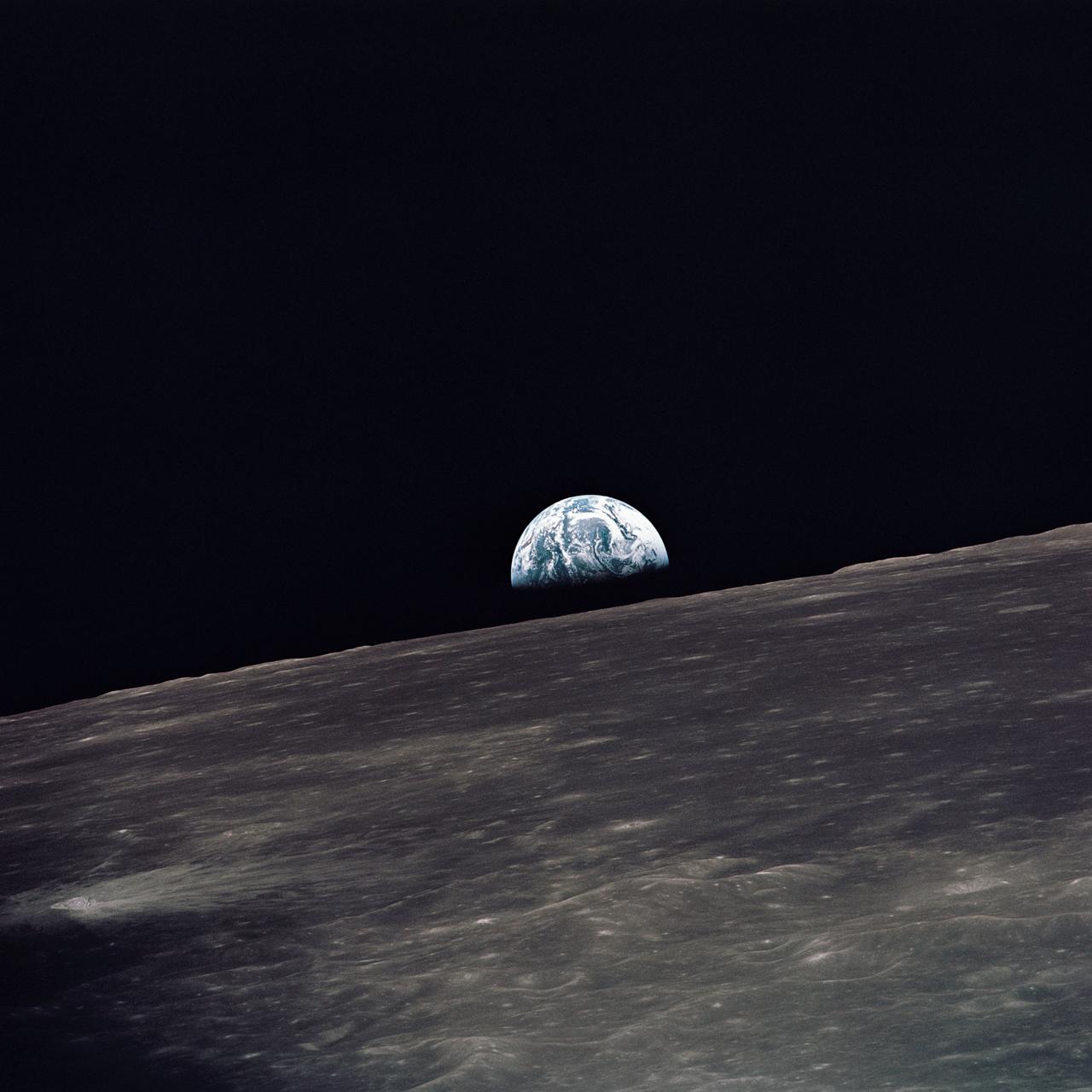
AS10-27-3890 (18-26 May 1969) --- A view of Earth rising above the lunar horizon photographed from the Apollo 10 Lunar Module, looking west in the direction of travel. The Lunar Module at the time the picture was taken was located above the lunar farside highlands at approximately 105 degrees east longitude.

AS11-36-5299 (16 July 1969) --- This view of Earth showing clouds over water was photographed from the Apollo 11 spacecraft following translunar injection. While astronauts Neil A. Armstrong, commander, and Edwin E. Aldrin Jr., lunar module pilot, descended in the Lunar Module (LM) "Eagle" to explore the Sea of Tranquility region of the moon, astronaut Michael Collins, command module pilot, remained with the Command and Service Modules (CSM) "Columbia" in lunar orbit.
AS11-36-5355 (17 July 1969) --- Most of Africa and portions of Europe and Asia can be seen in this spectacular photograph taken from the Apollo 11 spacecraft during its trans-lunar coast toward the moon. Apollo 11, with astronauts Neil A. Armstrong, commander; Michael Collins, command module pilot; and Edwin E. Aldrin Jr., lunar module pilot, onboard was already 98,000 nautical miles from Earth when this picture was made. While astronauts Armstrong and Aldrin descended in the Lunar Module (LM) "Eagle" to explore the Sea of Tranquility region of the moon, astronaut Collins remained with the Command and Service Modules (CSM) "Columbia" in lunar orbit.
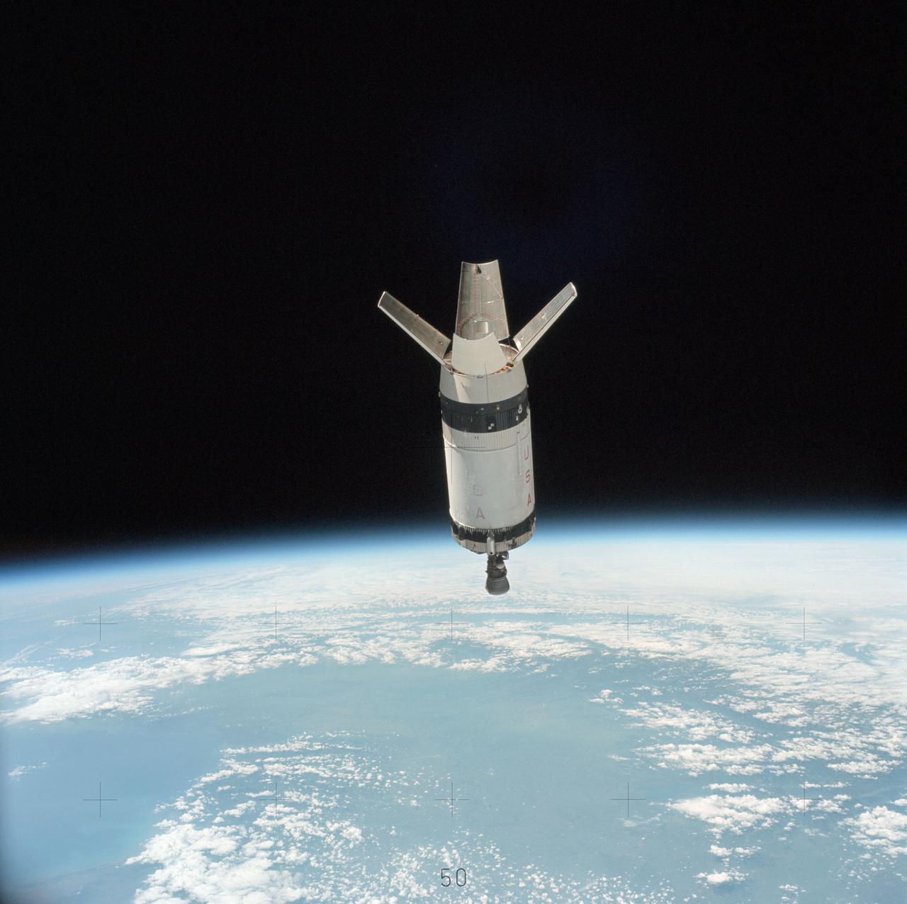
SL3-114-1625 (July-September 1973) --- An excellent view of the expended S-IVB second stage of the Skylab 3/Saturn 1B space vehicle is seen in this photograph taken from the Skylab 3 Command and Service Module (CSM) in Earth orbit. The land mass below is Italy and France, with part of the Mediterranean Sea visible. This photograph was taken with a handheld 70mm Hasselblad camera using a 100mm lens, and medium speed Ektachrome film. Photo credit: NASA
AS08-16-2596 (21-27 Dec. 1968) --- View of Earth as photographed by the Apollo 8 astronauts during their lunar orbit mission. North is about five percent to the right of vertical. The sunset terminator crosses North and South America. Clouds cover most of the United States. Only the desert southwest and Florida are clear.
AS11-44-6689 (16-24 July 1969) --- One-third of the Earth's sphere illuminated, Earth's terminator, sunglint, a portion of east Africa, as photographed from the Apollo 11 spacecraft during its first lunar landing mission. While astronauts Neil A. Armstrong, commander, and Edwin E. Aldrin Jr., lunar module pilot, descended in the Lunar Module (LM) "Eagle" to explore the Sea of Tranquility region of the moon, astronaut Michael Collins, command module pilot, remained with the Command and Service Modules (CSM) "Columbia" in lunar orbit.
AS16-118-18873 (16 April 1972) --- A good view of Earth photographed shortly after trans-lunar injection of April 16, 1972. Although there is much cloud cover (over Canada and the oceans), the United States in large part, most of Mexico and some parts of Central America are clearly visible. Note Lake Michigan and Lake Superior, also note the Bahama Banks at upper right part of the sphere. A large part of the Rocky Mountain Range is also visible. Just beginning man's fifth lunar landing mission were astronauts John W. Young, commander; Thomas K. Mattingly II, command module pilot; and Charles M. Duke Jr., lunar module pilot. While astronauts Young and Duke descended in the Lunar Module (LM) to explore the moon, astronaut Mattingly remained with the Command and Service Modules (CSM) in lunar orbit.

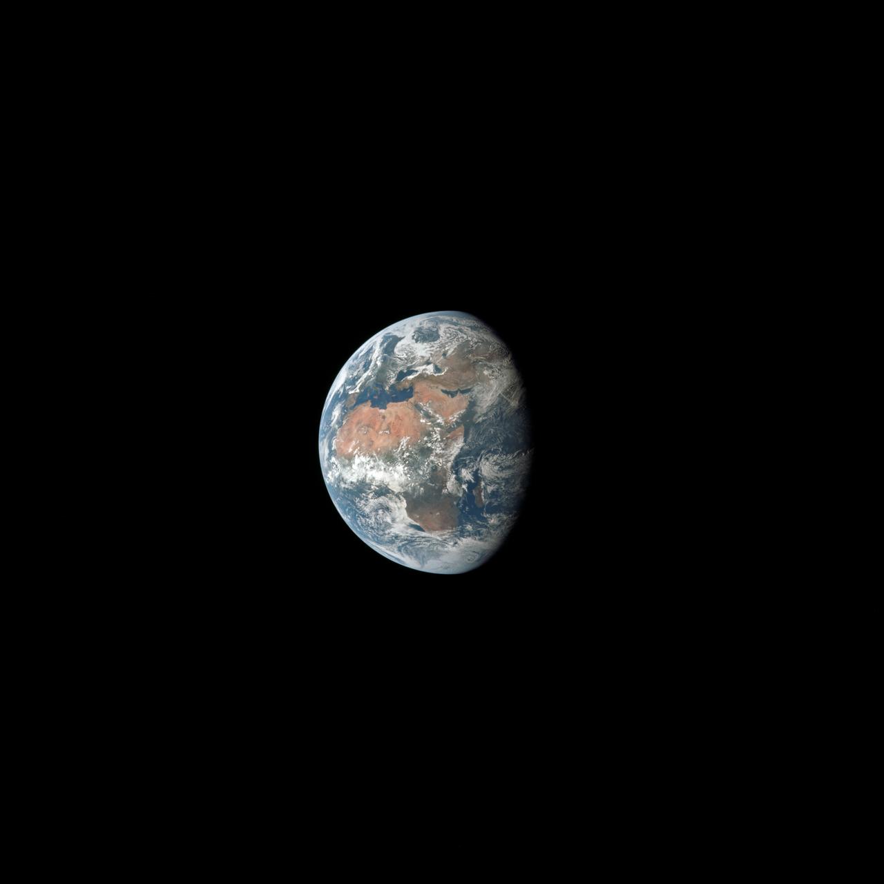
AS15-91-12343 (26 July 1971) --- This view of Earth was photographed by the Apollo 15 crewmen as they sped toward the fourth lunar landing. The spacecraft was between 25,000 and 30,000 nautical miles from Earth when this photo was made. The United States (note Florida), Central America and part of Canada can be seen at the left side of the picture, with South America at lower center. Spain and the northwest part of Africa can be seen at right. The Bahamas Banks, unique geological feature, can be seen (different shade of blue) east of Florida. Also note large North Atlantic storm front moving over Greenland in upper center.

AS10-34-5010 (18 May 1969) --- This photograph of Earth was taken from the Apollo 10 spacecraft shortly after trans-lunar insertion. The counter-clockwise arrangement of the cloud formations indicates a northern hemisphere view, although insufficient amounts of land are visible for exact location.
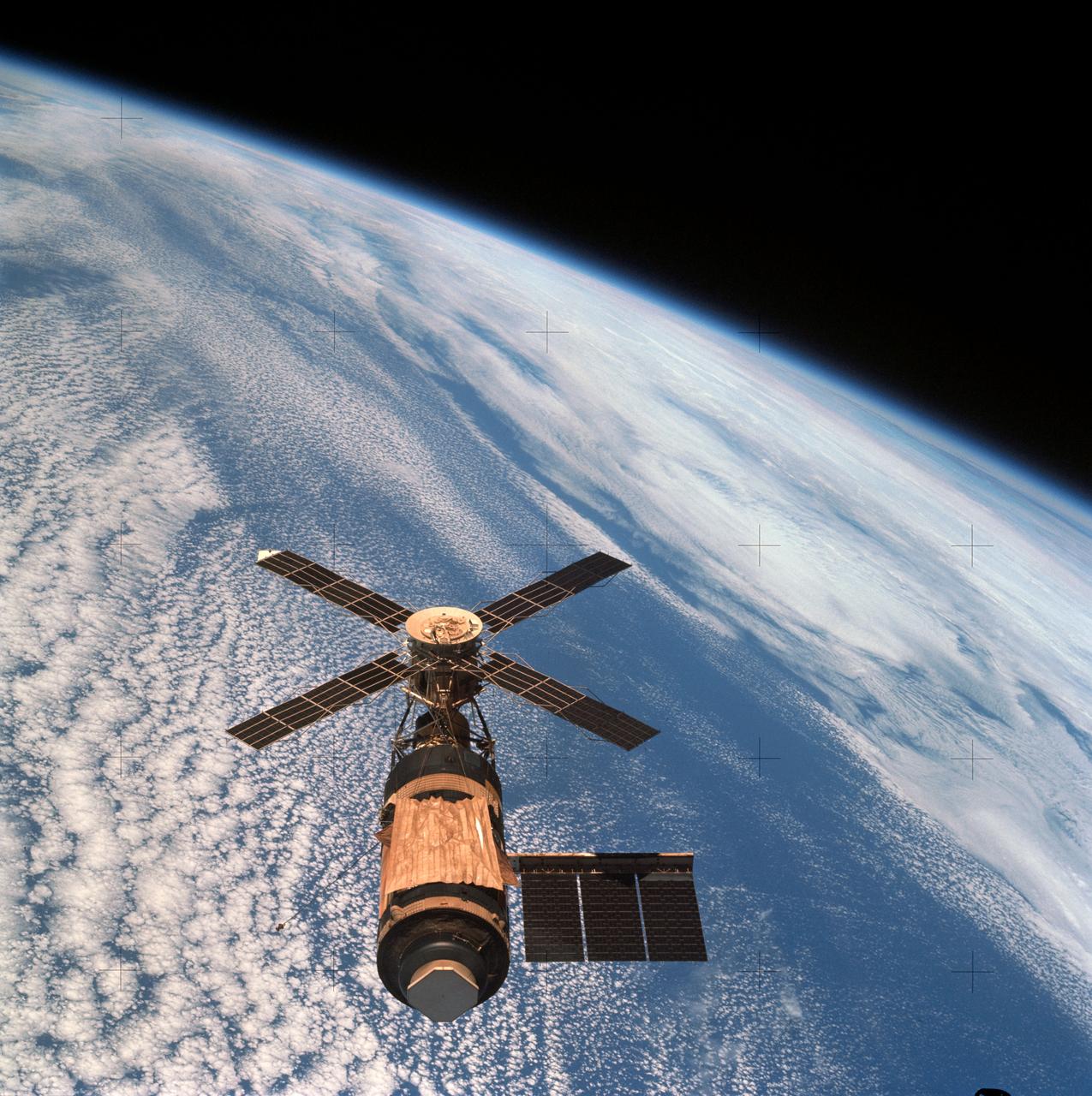
SL4-143-4706 (8 Feb. 1974) --- An overhead view of the Skylab space station cluster in Earth orbit as photographed from the Skylab 4 Command and Service Modules (CSM) during the final fly-around by the CSM before returning home. The space station is contrasted against a cloud-covered Earth. Note the solar shield which was deployed by the second crew of Skylab and from which a micro meteoroid shield has been missing since the cluster was launched on May 14, 1973. The Orbital Workshop (OWS) solar panel on the left side was also lost on workshop launch day. Inside the Command Module (CM) when this picture was made were astronaut Gerald P. Carr, commander; scientist-astronaut Edward G. Gibson, science pilot; and astronaut William R. Pogue, pilot. The crew used a 70mm hand-held Hasselblad camera to take this photograph. Photo credit: NASA
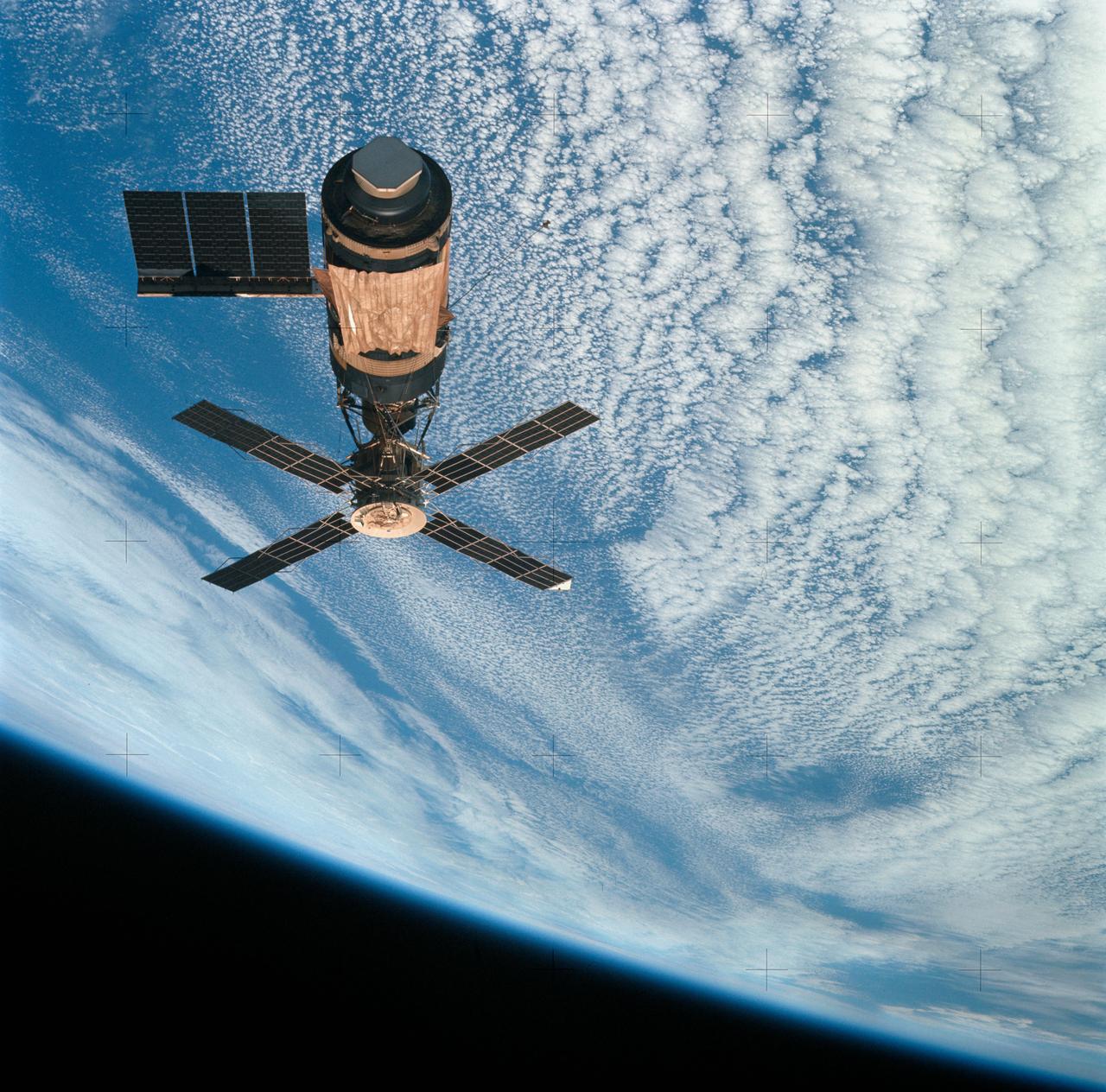
SL4-143-4707 (8 Feb. 1974) --- An overhead view of the Skylab space station cluster in Earth orbit as photographed from the Skylab 4 Command and Service Modules (CSM) during the final fly-around by the CSM before returning home. The space station is contrasted against a cloud-covered Earth. Note the solar shield which was deployed by the second crew of Skylab and from which a micrometeoroid shield has been missing since the cluster was launched on May 14, 1973. The OWS solar panel on the left side was also lost on workshop launch day. Photo credit: NASA
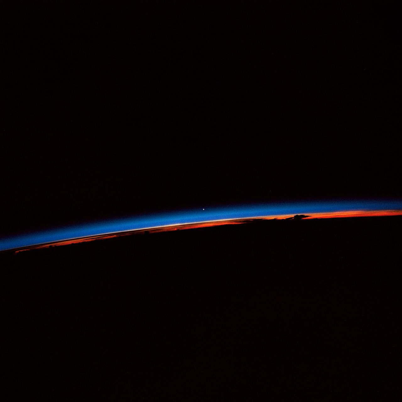
STS-30 Earth observation captured by crewmembers onboard Atlantis, Orbiter Vehicle (OV) 104, shows the sunset over the Earth as well as the planet Venus near the center of the frame. Jutting clouds are seen on the horizon, just beneath the blue strip of airglow.
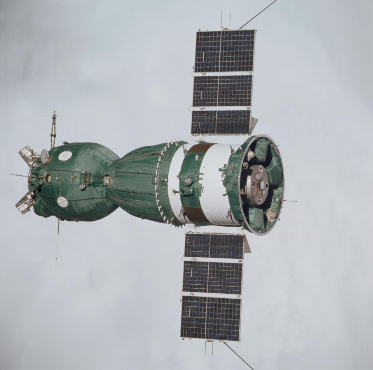
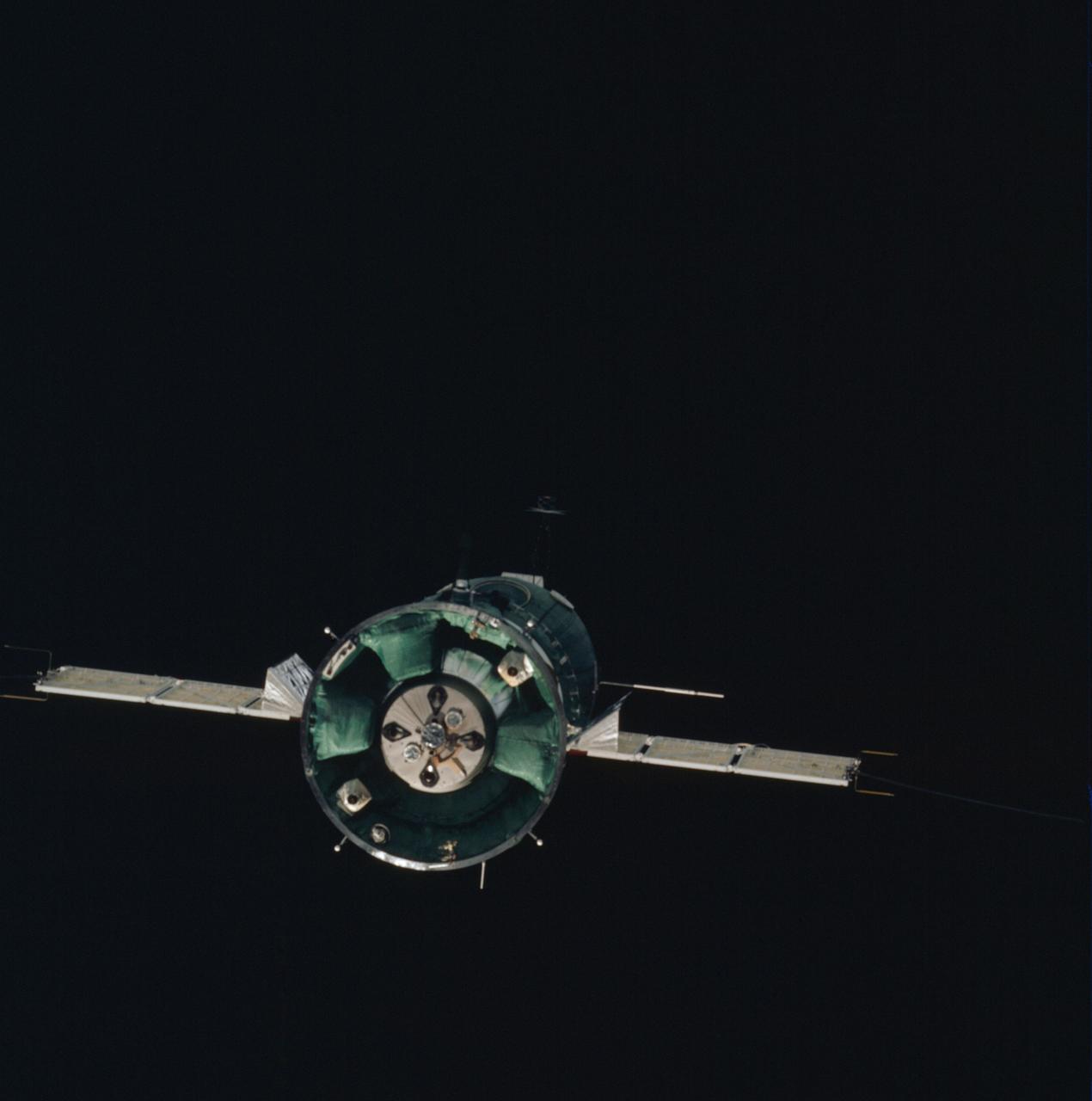
AST-01-056 (18 July 1975) --- An excellent view of the Soviet Soyuz spacecraft in Earth orbit, photographed from the American Apollo spacecraft during the joint U.S.-USSR Apollo-Soyuz Test Project (ASTP) docking mission in Earth orbit. The Soyuz is contrasted against a white-cloud background in this overhead view. The three major components of the Soyuz are the spherical-shaped Orbital Module, the bell-shaped Descent Vehicle and the cylindrical-shaped instrument Assembly Module from which two solar panels protrude. The docking system on the Orbital Module was specially designed to interface with the docking system on the Apollo's Docking Module. The ASTP astronauts and cosmonauts visited each other's spacecraft while the Soyuz and Apollo were docked in Earth orbit for two days. The Apollo crew consisted of astronauts Stafford, commander; Donald K. "Deke" Slayton, docking module pilot; and Vance D. Brand, command module pilot. The Soyuz 19 crew consisted of cosmonauts Leonov, command pilot; and Valeri N. Kubasov, flight engineer.
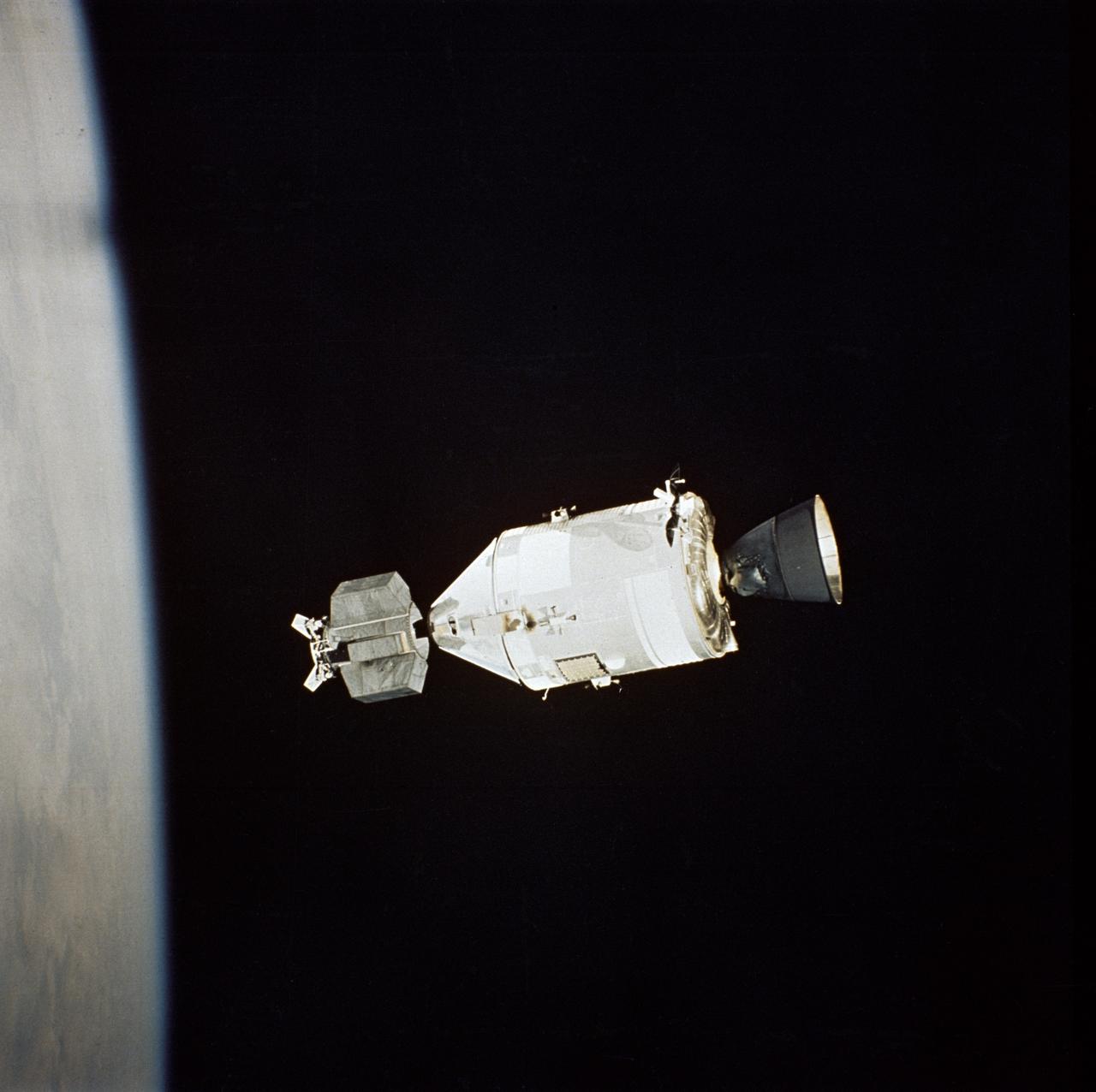
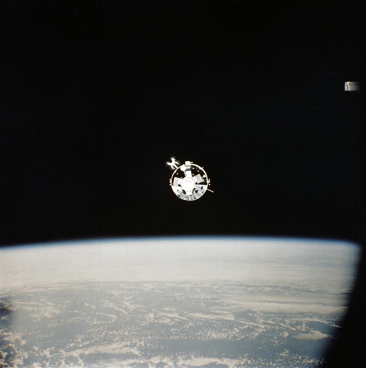
AST-32-2695 (17-19 July 1975) --- The American Apollo spacecraft as seen in Earth orbit from the Soviet Soyuz spacecraft during the joint U.S.-USSR Apollo-Soyuz Test Project mission. The Command/Service Module and Docking Module are contrasted against a black-sky background. The horizon of Earth is below. This picture was furnished by the USSR in an exchange of photography taken during the ASTP flight. The bell-shaped engine nozzle of the service propulsion system protrudes from the rear of the Service Module. Note the docking mechanism on the Docking Module. The American and Soviet spacecraft were joined together in space for approximately 47 hours on July 17-18-19, 1975. PHOTO COURTESY: USSR ACADEMY OF SCIENCES

AS11-44-6549 (16-24 July 1969) --- This view from the Apollo 11 spacecraft shows Earth rising above the moon's horizon. The lunar terrain pictured is in the area of Smyth's Sea on the nearside. Coordinates of the center of the terrain are 86 degrees east longitude and 3 degrees north latitude. While astronauts Neil A. Armstrong, commander, and Edwin E. Aldrin Jr., lunar module pilot, descended in the Lunar Module (LM) "Eagle" to explore the Sea of Tranquility region of the moon, astronaut Michael Collins, command module pilot, remained with the Command and Service Modules (CSM) "Columbia" in lunar orbit.
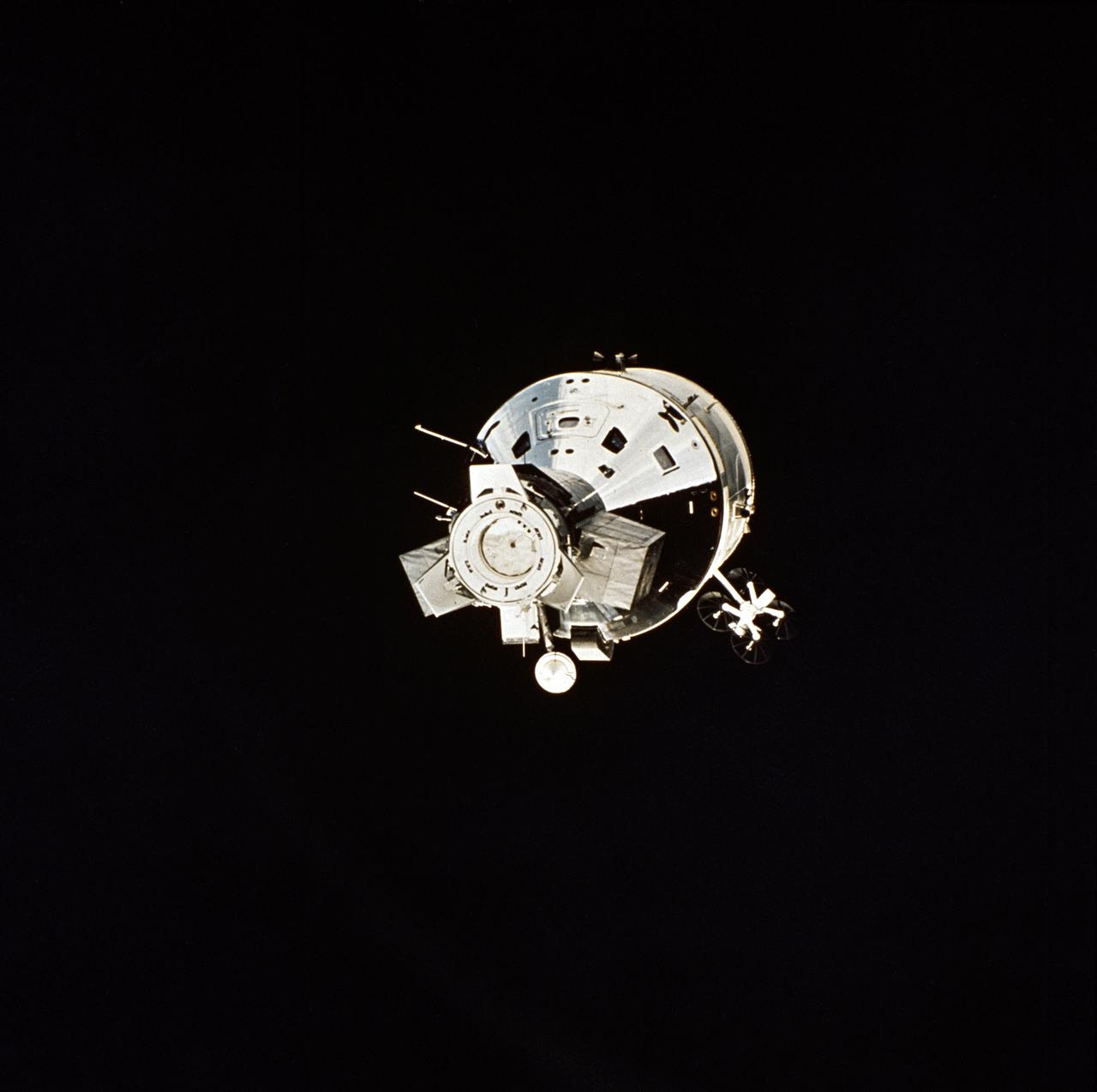
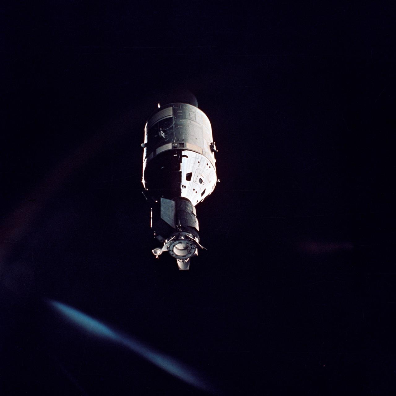
AST-32-2691 (17-19 July 1975) --- The American Apollo spacecraft as seen in Earth orbit from the Soviet Soyuz spacecraft during the joint U.S.-USSR Apollo-Soyuz Test Project mission. The Command/Service Module and Docking Module are contrasted against a black-sky background. This is a near "head on" view of the Apollo. This picture was furnished by the USSR in an exchange of photography taken during the ASTP flight. Note the docking mechanism and docking target on the Docking Module. The four dish-like reflectors of the unified S-band high-gain antenna protrude from the side of the Service Module. The American and Soviet spacecraft were joined together in space for approximately 47 hours on July 17-18-19, 1975. PHOTO COURTESY: USSR ACADEMY OF SCIENCES
AST-01-053 (17-19 July 1975) --- The Soviet Soyuz spacecraft is contrasted against a black-sky background in this photograph taken in Earth orbit. This view is looking toward the aft end of the Soyuz. Two solar panels protrude out from the spacecraft's Instrument Assembly Module. The ASTP astronauts and cosmonauts visited each other's spacecraft while the Soyuz and Apollo were docked in Earth orbit for two days.

AS11-44-6552 (16-24 July 1969) --- This view of Earth rising over the moon's horizon was taken from the Apollo spacecraft. The lunar terrain pictured is in the area of Smyth's Sea on the nearside. Coordinates of the center of the terrain are 85 degrees east longitude and 3 degrees north latitude. While astronaut Neil A. Armstrong, commander; and Edwin E. Aldrin Jr., lunar module pilot, descended in the Lunar Module (LM) "Eagle" to explore the Sea of Tranquility region of the moon, astronaut Michael Collins remained with the Command and Service Modules (CSM) "Columbia" in lunar orbit.
AST-32-2675 (17-19 July 1975) --- The American Apollo spacecraft as seen in Earth orbit from the Soviet Soyuz spacecraft during the joint U.S.-USSR Apollo-Soyuz Test Project mission. The Command/Service Module and Docking Module are contrasted against a black-sky background. This is a "head on" view of the Apollo. The horizon of Earth is below. This picture was furnished by the USSR in an exchange of photography taken during the ASTP flight. The American and Soviet spacecraft were joined together in space for approximately 47 hours on July 17-18-19, 1975. Note the docking mechanism on the Docking Module. PHOTO COURTESY: USSR ACADEMY OF SCIENCES
AST-32-2686 (17-19 July 1975) --- The American Apollo spacecraft as seen in Earth orbit from the Soviet Soyuz 19 spacecraft during the joint U.S.-USSR Apollo Soyuz Test Project (ASTP) mission. The Command and Service Module (CSM) and Docking Module (DM) are contrasted against a black-sky background. Light reflected in the camera streaks the image. Note the docking mechanism and docking target on the DM. On the left the bell-shaped engine nozzle of the service propulsion system protrudes from the rear of the Service Module (SM). The American and Soviet spacecraft were joined together in space for approximately 47 hours on July 17, 18, 19, 1975. This picture was furnished by the USSR in an exchange of photography taken during the ASTP flight. The Apollo crew consisted of astronauts Thomas P. Stafford, commander; Donald K. "Deke" Slayton, docking module pilot; and Vance D. Brand, command module pilot. The Soyuz 19 crew consisted of cosmonauts Aleksei A. Leonov, command pilot; and Valeri N. Kubasov, flight engineer.

art002e014225 (April 6, 2026) – Seen from afar, Earth appears as a small, delicate waning crescent suspended in the darkness of space, captured by the crew during the Artemis II mission. Only a thin sliver of the planet is illuminated, resembling the familiar crescent phases often seen when observing the Moon from Earth. Despite its distance, faint hints of Earth’s blue tones and cloud patterns are visible, offering a striking perspective of our home planet from deep space.
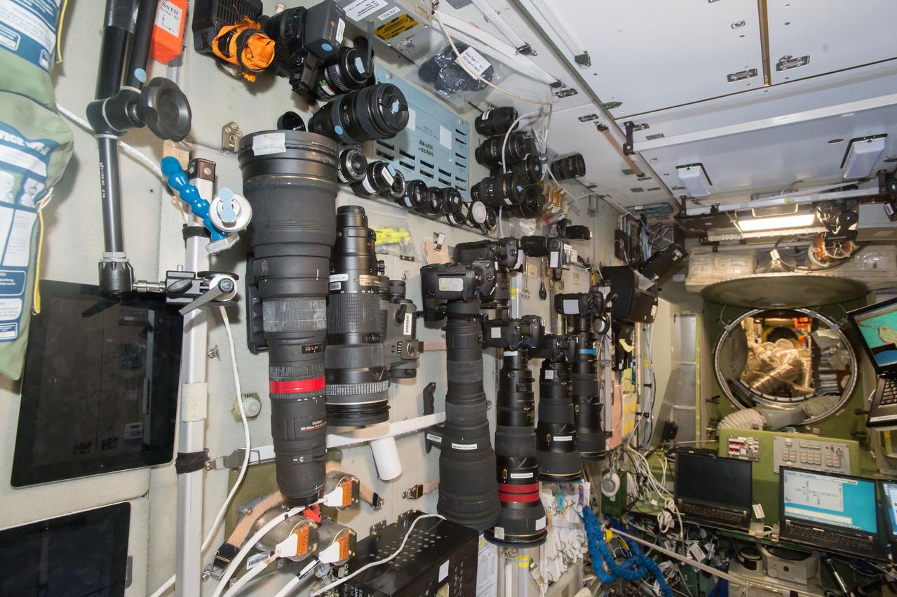
iss050e029074 (1/7/2017) --- A large selection of cameras and lenses are available to take Crew Earth Observations (CEO) photos. These cameras are in the Services Module part of the Russian Segment and near one of the windows used for Earth photography. CEO imagery provides researchers on Earth with key data to understand the planet from the perspective of the ISS. Crew members have been photographing Earth from space since the early Mercury missions beginning in 1961. The images taken from the ISS ensure this record remains unbroken.
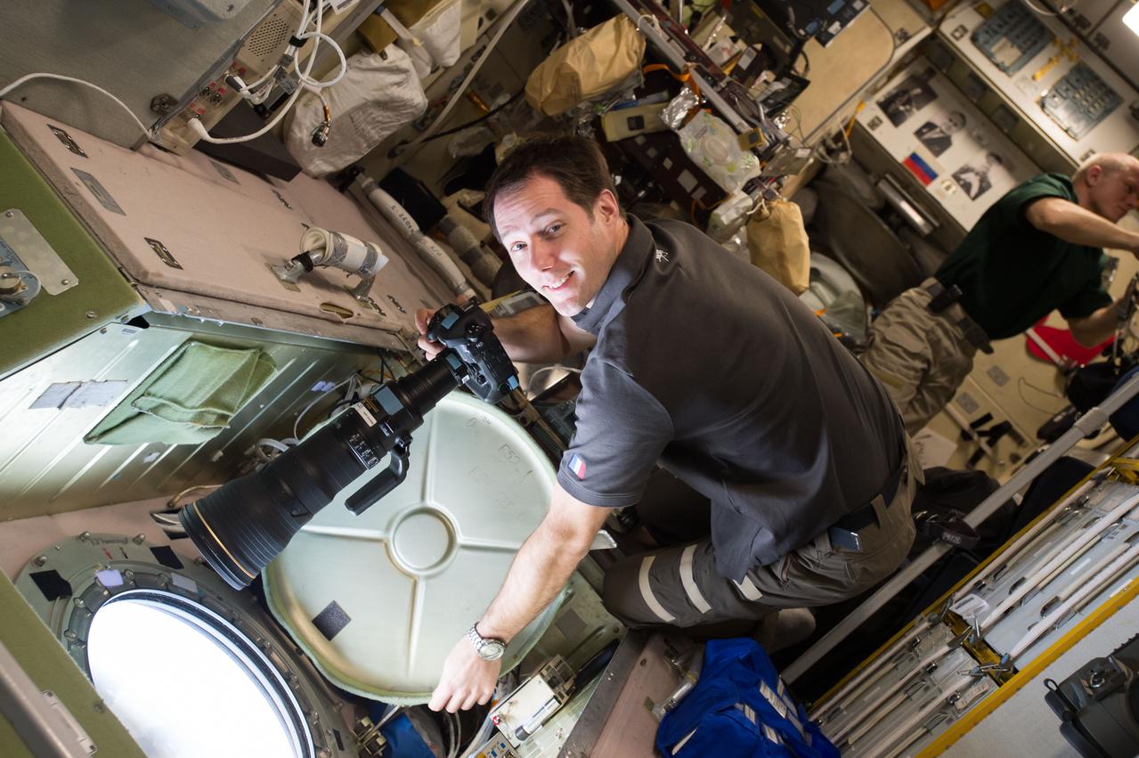
iss050e020100 (12/28/2016) --- European Space Agency (ESA) astonaut Thomas Pesquet preparing to take Crew Earth Observations (CEO) photos from the Service Module (SM) window. Cosmonaut Oleg Novitskiy is visible in the background. CEO imagery provides researchers on Earth with key data to understand the planet from the perspective of the ISS. Crew members have been photographing Earth from space since the early Mercury missions beginning in 1961. The images taken from the ISS ensure this record remains unbroken.

This illustration shows the seven TRAPPIST-1 planets as they might look as viewed from Earth using a fictional, incredibly powerful telescope. The sizes and relative positions are correctly to scale: This is such a tiny planetary system that its sun, TRAPPIST-1, is not much bigger than our planet Jupiter, and all the planets are very close to the size of Earth. Their orbits all fall well within what, in our solar system, would be the orbital distance of our innermost planet, Mercury. With such small orbits, the TRAPPIST-1 planets complete a "year" in a matter of a few Earth days: 1.5 for the innermost planet, TRAPPIST-1b, and 20 for the outermost, TRAPPIST-1h. This particular arrangement of planets with a double-transit reflect an actual configuration of the system during the 21 days of observations made by NASA's Spitzer Space Telescope in late 2016. The system has been revealed through observations from NASA's Spitzer Space Telescope and the ground-based TRAPPIST (TRAnsiting Planets and PlanetesImals Small Telescope) telescope, as well as other ground-based observatories. The system was named for the TRAPPIST telescope. http://photojournal.jpl.nasa.gov/catalog/PIA21429
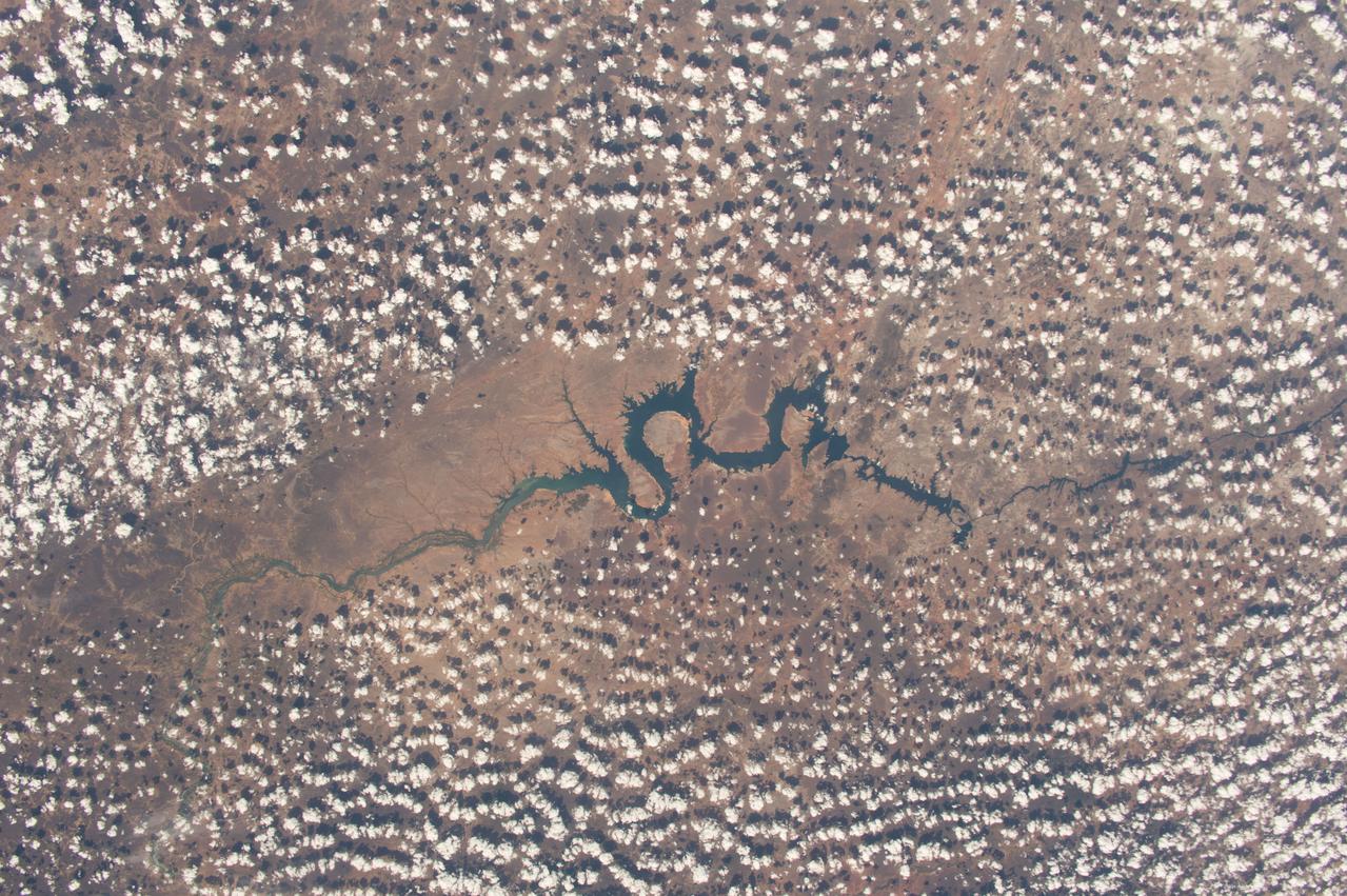
iss050e013545 (12/2/2016) --- A view of the São Francisco River in Brazil. Crew Earth Observations (CEO) imagery provides researchers on Earth with key data to understand the planet from the perspective of the ISS. Crew members have been photographing Earth from space since the early Mercury missions beginning in 1961. The images taken from the ISS ensure this record remains unbroken.
AS11-44-6634 (21 July 1969) --- The Apollo 11 Lunar Module (LM) ascent stage, with astronauts Neil A. Armstrong and Edwin E. Aldrin Jr. onboard, is photographed from the Command and Services Modules (CSM) in lunar orbit. This view is looking west with the Earth rising above the lunar horizon. Astronaut Michael Collins remained with the CSM in lunar orbit while Armstrong and Aldrin explored the moon. The LM is approaching from below. The maze area in the background is Smyth's Sea. At right center is International Astronomical Union crater No. 189.
AS17-134-20473 (13 Dec. 1972) --- Earth appears in the far distant background above the hi-gain antenna of the Lunar Roving Vehicle in this photograph taken by scientist-astronaut Harrison H. Schmitt during the third Apollo 17 extravehicular activity (EVA) at the Taurus-Littrow landing site. Astronaut Eugene A. Cernan, Apollo 17 commander, stands beside the LRV. Schmitt is the mission's lunar module pilot. While Cernan and Schmitt descended in the lunar module "Challenger" to explore the moon, astronaut Ronald E. Evans, command module pilot, remained with the Command and Service Modules in lunar orbit.

AS11-44-6642 (21 July 1969) --- The Apollo 11 Lunar Module ascent stage, with astronauts Neil A. Armstrong and Edwin E. Aldrin Jr. aboard, is photographed from the Command and Service Modules (CSM) during rendezvous in lunar orbit. The Lunar Module (LM) was making its docking approach to the CSM. Astronaut Michael Collins remained with the CSM in lunar orbit while the other two crewmen explored the lunar surface. The large, dark-colored area in the background is Smyth's Sea, centered at 85 degrees east longitude and 2 degrees south latitude on the lunar surface (nearside). This view looks west. The Earth rises above the lunar horizon.

This artist's concept appeared on the Feb. 23, 2017 cover of the journal Nature announcing that the TRAPPIST-1 star, an ultra-cool dwarf, has seven Earth-size planets orbiting it. Any of these planets could have liquid water on them. Planets that are farther from the star are more likely to have significant amounts of ice, especially on the side that faces away from the star. The system has been revealed through observations from NASA's Spitzer Space Telescope and the ground-based TRAPPIST (TRAnsiting Planets and PlanetesImals Small Telescope) telescope, as well as other ground-based observatories. The system was named for the TRAPPIST telescope. http://photojournal.jpl.nasa.gov/catalog/PIA21421

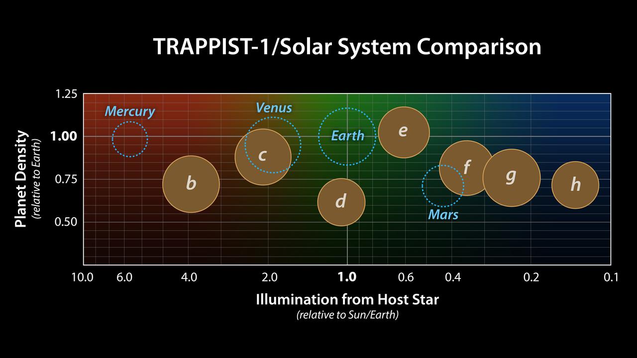
This graph presents measured properties of the seven TRAPPIST-1 exoplanets (labeled b through h), showing how they stack up with one another as well as with Earth and the other inner rocky worlds in our own solar system. The relative sizes of the planets are indicated by the circles. All of the known TRAPPIST-1 planets are larger than Mars, with five of them within 15% of the diameter of Earth. The vertical axis shows the uncompressed densities of the planets. Density, calculated from a planet's mass and volume, is the first important step in understanding its composition. Uncompressed density takes into account that the larger a planet is, the more its own gravity will pack the planet's material together and increase its density. Uncompressed density, therefore, usually provides a better means of comparing the composition of planets. The plot shows that the uncompressed densities of the TRAPPIST-1 planets are similar to one another, suggesting they may have all have a similar composition. The four rocky planets in our own solar system show more variation in density compared to the seven TRAPPIST-1 planets. Mercury, for example, contains a much higher percentage of iron than the other three rocky planets and thus has a much higher uncompressed density. The horizontal axis shows the level of illumination that each planet receives from its host star. The TRAPPIST-1 star is a mere 9% the mass of our Sun, and its temperature is much cooler. But because the TRAPPIST-1 planets orbit so closely to their star, they receive comparable levels of light and heat to Earth and its neighboring planets. The corresponding "habitable zones" — regions where an Earth-like planet could potentially support liquid water on its surface — of the two planetary systems are indicated near the top of the plot. The the two zones do not line up exactly because the cooler TRAPPIST-1 star emitting more of its light in the form of infrared radiation that is more efficiently absorbed by an Earth-like atmosphere. Since it takes less illumination to reach the same temperatures, the habitable zone shifts farther away from the star. The masses and densities of the TRAPPIST-1 planets were determined by measurements of slight variations in the timings of their orbits using extensive observations made by NASA's Spitzer and Kepler space telescopes, in combination with data from Hubble and a number of ground-based telescopes. The latest analysis, which includes Spitzer's complete record of over 1,000 hours of TRAPPIST-1 observations, has reduced the uncertainties of the mass measurements to a mere 3-6%. These are among the most accurate measurements of planetary masses anywhere outside of our solar system. https://photojournal.jpl.nasa.gov/catalog/PIA24371

This chart shows, on the top row, artist concepts of the seven planets of TRAPPIST-1 with their orbital periods, distances from their star, radii and masses as compared to those of Earth. On the bottom row, the same numbers are displayed for the bodies of our inner solar system: Mercury, Venus, Earth and Mars. The TRAPPIST-1 planets orbit their star extremely closely, with periods ranging from 1.5 to only about 20 days. This is much shorter than the period of Mercury, which orbits our sun in about 88 days. The artist concepts show what the TRAPPIST-1 planetary system may look like, based on available data about their diameters, masses and distances from the host star. The system has been revealed through observations from NASA's Spitzer Space Telescope and the ground-based TRAPPIST (TRAnsiting Planets and PlanetesImals Small Telescope) telescope, as well as other ground-based observatories. The system was named for the TRAPPIST telescope. The seven planets of TRAPPIST-1 are all Earth-sized and terrestrial, according to research published in 2017 in the journal Nature. TRAPPIST-1 is an ultra-cool dwarf star in the constellation Aquarius, and its planets orbit very close to it. http://photojournal.jpl.nasa.gov/catalog/PIA21425
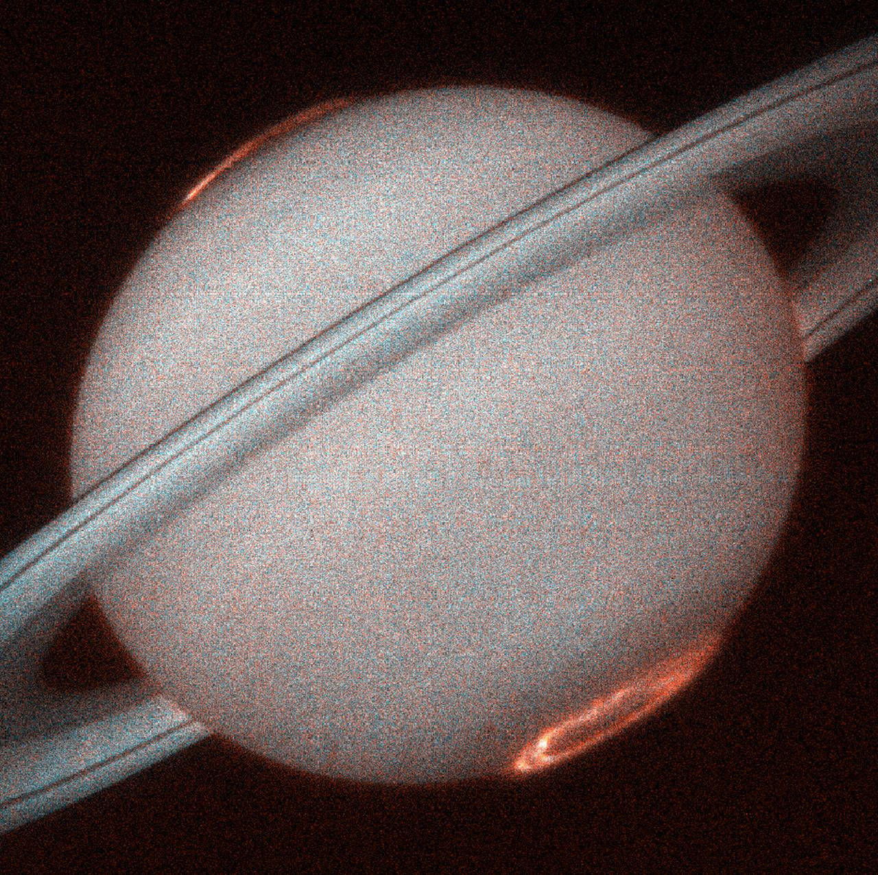
This is the first image of Saturn's ultraviolet aurora taken by the Space Telescope Imaging Spectrograph (STIS) on board the Hubble Space Telescope (HST) in October 1998, when Saturn was a distance of 810 million miles (1.3 billion kilometers) from Earth. The new instrument, used as a camera, provides more than 10 times the sensitivity of the previous HST instruments in the ultraviolet. STIS images reveal exquisite detail never before seen in the spectacular auroral curtains of light that encircle Saturn's north and south poles which rise more than a thousand miles above the cloud tops. Saturn's auroral displays are caused by an energetic wind from the Sun that sweeps over the planet, much like the Earth's aurora that is occasionally seen in the nighttime sky. Unlike the Earth, Saturn's aurora is only seen in ultraviolet light that is invisible from the Earth's surface, hence can only be observed from space.
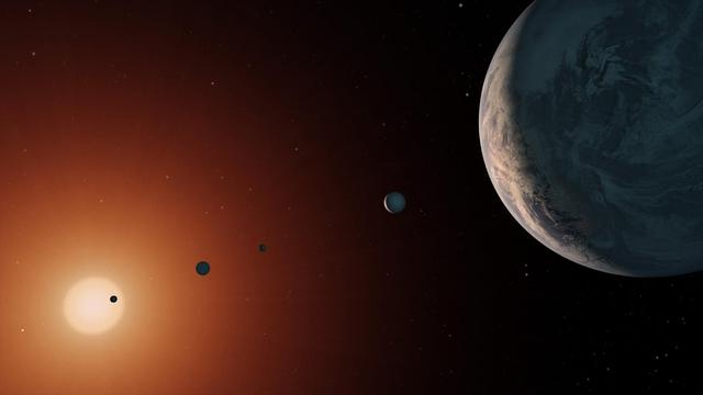
This illustration shows what the TRAPPIST-1 system might look like from a vantage point near planet TRAPPIST-1f (at right). The system has been revealed through observations from NASA's Spitzer Space Telescope and the ground-based TRAPPIST (TRAnsiting Planets and PlanetesImals Small Telescope) telescope, as well as other ground-based observatories. The system was named for the TRAPPIST telescope. The seven planets of TRAPPIST-1 are all Earth-sized and terrestrial, according to research published in 2017 in the journal Nature. TRAPPIST-1 is an ultra-cool dwarf star in the constellation Aquarius, and its planets orbit very close to it. They are likely all tidally locked, meaning the same face of the planet is always pointed at the star, as the same side of our moon is always pointed at Earth. This creates a perpetual night side and perpetual day side on each planet. TRAPPIST-1b and c receive the most light from the star and would be the warmest. TRAPPIST-1e, f and g all orbit in the habitable zone, the area where liquid water is most likely to be detected. But any of the planets could potentially harbor liquid water, depending on their compositions. https://photojournal.jpl.nasa.gov/catalog/PIA21751
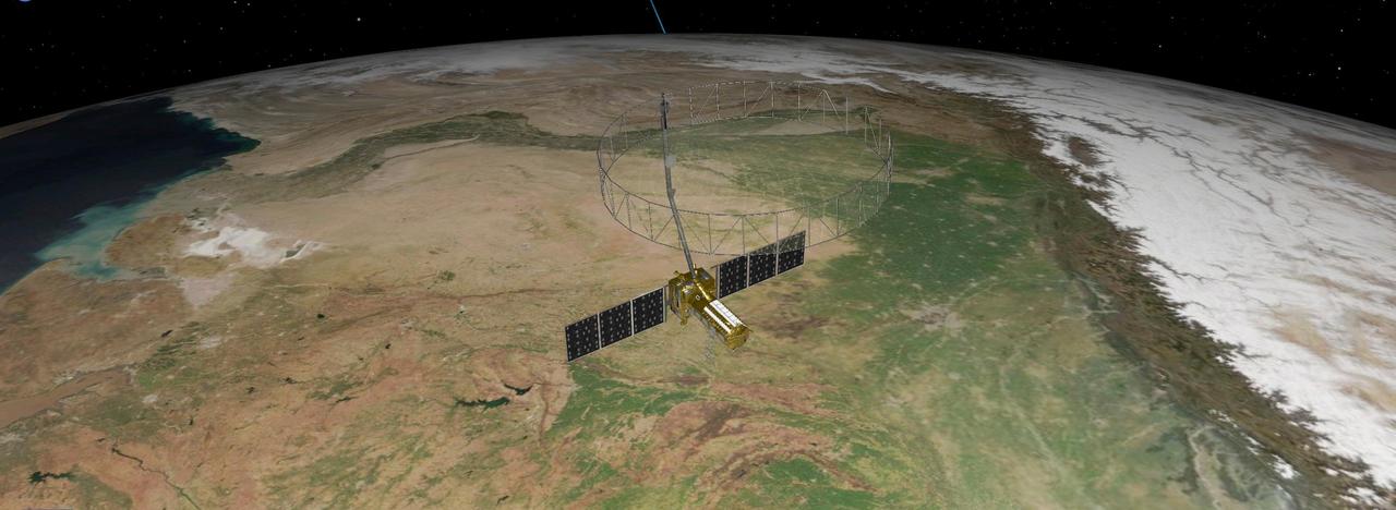
This artist's concept depicts the NISAR satellite orbiting Earth over northeastern India. Short for NASA-ISRO Synthetic Aperture Radar, the mission is an equal collaboration between the NASA and the Indian Space Research Organisation and marks the first time the two agencies have cooperated on hardware development for an Earth-observing mission. Observations from NISAR will benefit humanity by helping researchers around the world better understand changes in our planet's surface, including its ice sheets, glaciers, and sea ice. It also will capture changes in forest and wetland ecosystems and track movement and deformation of our planet's crust by phenomena such as earthquakes, landslides, and volcanic activity. The global and rapid coverage from NISAR will provide unprecedented opportunities for disaster response, producing data to assist in mitigating and assessing damage, with observations before and after catastrophic events available in short time frames. NISAR will launch from ISRO's Satish Dhawan Space Centre on India's southeastern coast in 2025. https://photojournal.jpl.nasa.gov/catalog/PIA26496
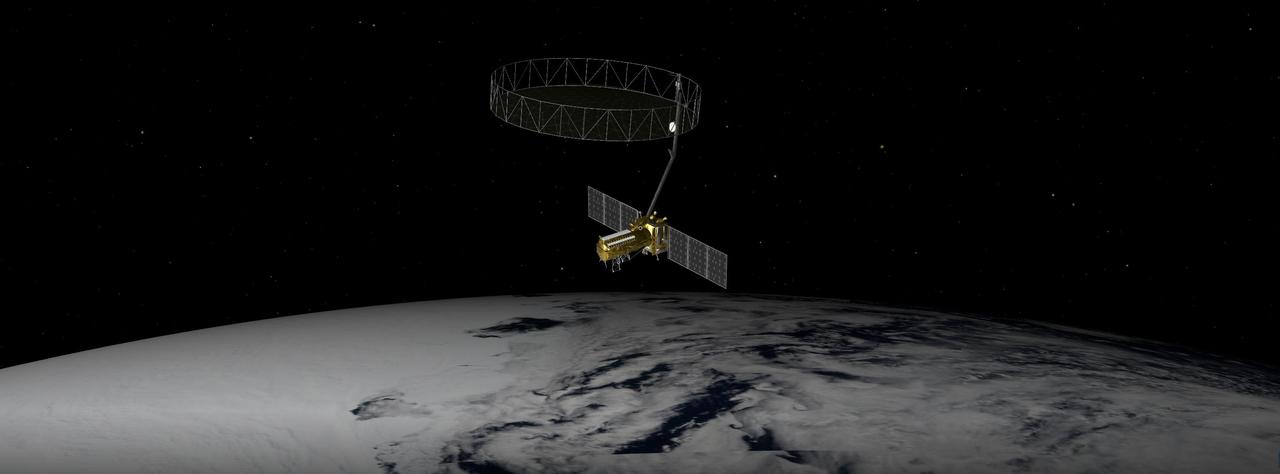
This artist's concept depicts the NISAR satellite orbiting Earth over Antarctica. Short for NASA-ISRO Synthetic Aperture Radar, the mission is an equal collaboration between the NASA and the Indian Space Research Organisation and marks the first time the two agencies have cooperated on hardware development for an Earth-observing mission. Observations from NISAR will benefit humanity by helping researchers around the world better understand changes in our planet's surface, including its ice sheets, glaciers, and sea ice. It also will capture changes in forest and wetland ecosystems and track movement and deformation of our planet's crust by phenomena such as earthquakes, landslides, and volcanic activity. The global and rapid coverage from NISAR will provide unprecedented opportunities for disaster response, producing data to assist in mitigating and assessing damage, with observations before and after catastrophic events available in short time frames. NISAR will launch from ISRO's Satish Dhawan Space Centre on India's southeastern coast in March 2025. https://photojournal.jpl.nasa.gov/catalog/PIA26492
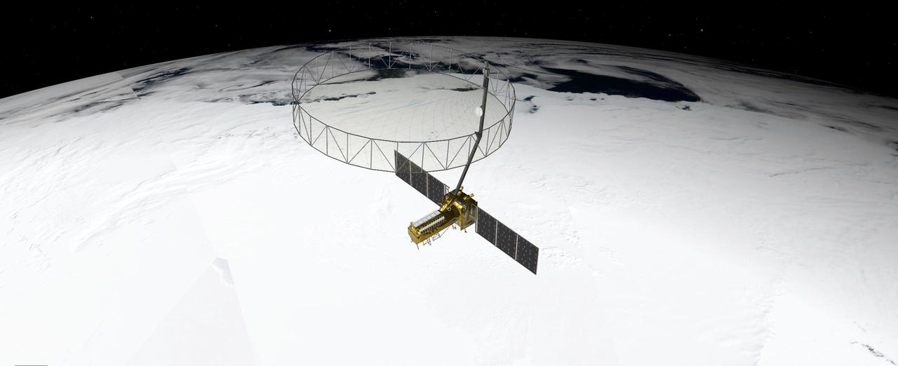
This artist's concept depicts the NISAR satellite orbiting Earth over Antarctica. Short for NASA-ISRO Synthetic Aperture Radar, the mission is an equal collaboration between the NASA and the Indian Space Research Organisation and marks the first time the two agencies have cooperated on hardware development for an Earth-observing mission. Observations from NISAR will benefit humanity by helping researchers around the world better understand changes in our planet's surface, including its ice sheets, glaciers, and sea ice, which are collectively known as the cryosphere. It also will capture changes in forest and wetland ecosystems and track movement and deformation of our planet's crust by phenomena such as earthquakes, landslides, and volcanic activity. The global and rapid coverage from NISAR will provide unprecedented opportunities for disaster response, producing data to assist in mitigating and assessing damage, with observations before and after catastrophic events available in short time frames. NISAR will launch from ISRO's Satish Dhawan Space Centre on India's southeastern coast in 2025. https://photojournal.jpl.nasa.gov/catalog/PIA26493
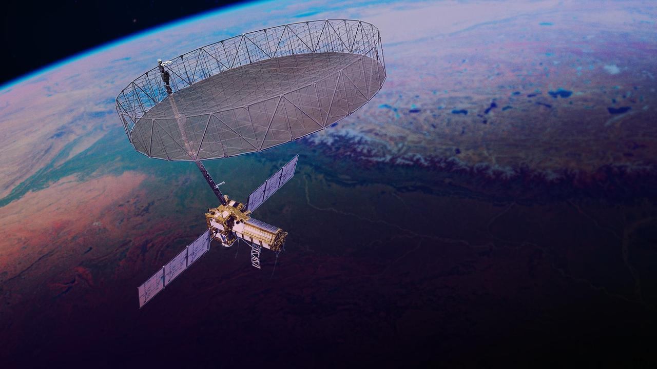
This artist's concept depicts the NISAR satellite orbiting Earth. Short for NASA-ISRO Synthetic Aperture Radar, the mission is an equal collaboration between NASA and the Indian Space Research Organisation and marks the first time the two agencies have cooperated on hardware development for an Earth-observing mission. Observations from NISAR will benefit humanity by helping researchers around the world better understand changes in our planet's surface, including its ice sheets, glaciers, and sea ice. It also will capture changes in forest and wetland ecosystems and track movement and deformation of our planet's crust by phenomena such as earthquakes, landslides, and volcanic activity. The global and rapid coverage from NISAR will provide unprecedented support for disaster response, producing data to assist in mitigating and assessing damage, with observations before and after catastrophic events available in short time frames. NISAR launched from ISRO's Satish Dhawan Space Centre on India's southeastern coast on July 30, 2025. https://photojournal.jpl.nasa.gov/catalog/PIA26613

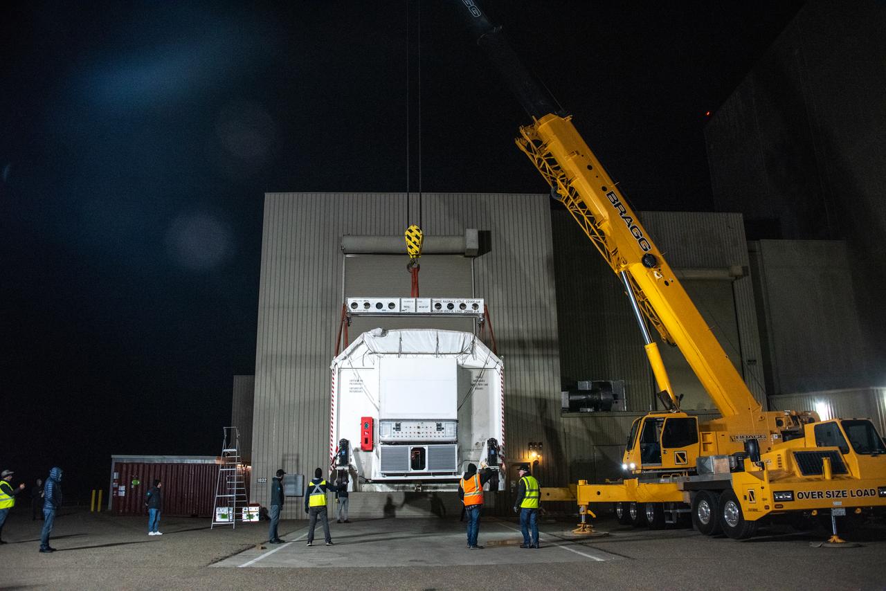
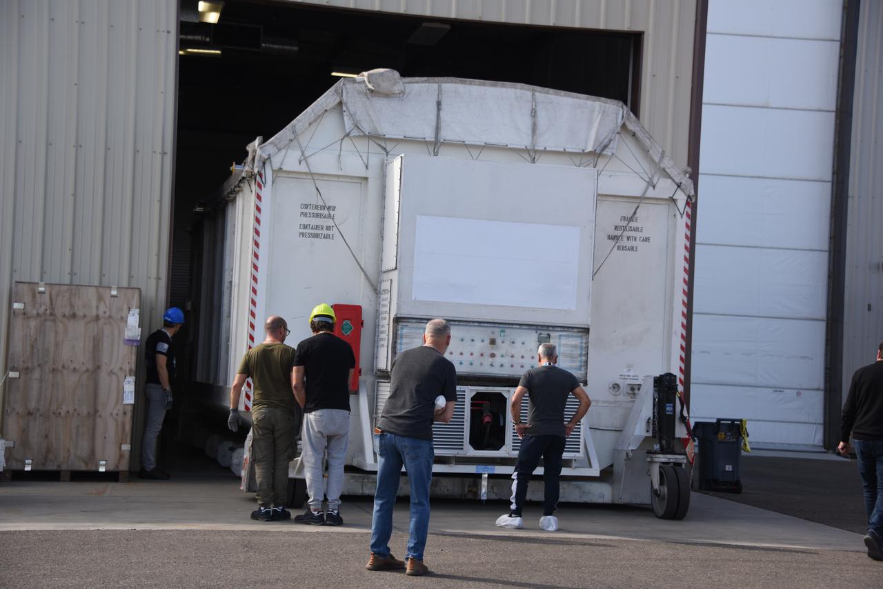
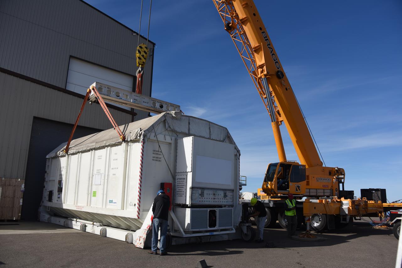
The ground service equipment for the Surface Water and Ocean Topography (SWOT) satellite arrives at Vandenberg Space Force Base in California on Oct. 13, 2022. SWOT is the first mission that will observe nearly all water on Earth’s surface, measuring the height of water in the planet’s lakes, rivers, reservoirs, and the ocean. The satellite is set to launch aboard a SpaceX Falcon 9 rocket in December from Vandenberg’s Space Launch Center-4 East. NASA’s Launch Services Program, based at the agency’s Kennedy Space Center in Florida, is managing the launch service.
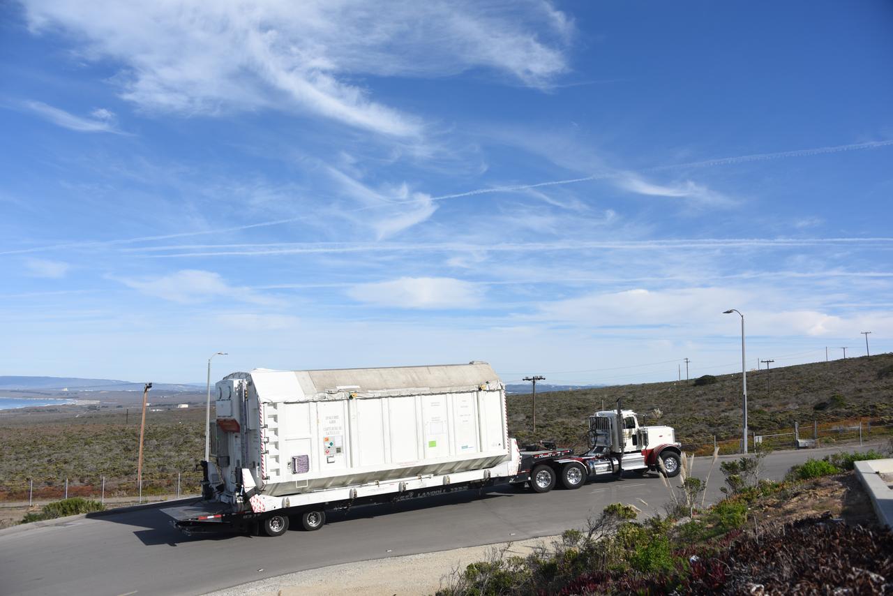
The Surface Water and Ocean Topography (SWOT) satellite arrives at Vandenberg Space Force Base in California on Oct. 16, 2022. SWOT is the first mission that will observe nearly all water on Earth’s surface, measuring the height of water in the planet’s lakes, rivers, reservoirs, and the ocean. The satellite is set to launch aboard a SpaceX Falcon 9 rocket in December from Vandenberg’s Space Launch Center-4 East. NASA’s Launch Services Program, based at the agency’s Kennedy Space Center in Florida, is managing the launch service.

The ground service equipment for the Surface Water and Ocean Topography (SWOT) satellite arrives at Vandenberg Space Force Base in California on Oct. 13, 2022. SWOT is the first mission that will observe nearly all water on Earth’s surface, measuring the height of water in the planet’s lakes, rivers, reservoirs, and the ocean. The satellite is set to launch aboard a SpaceX Falcon 9 rocket in December from Vandenberg’s Space Launch Center-4 East. NASA’s Launch Services Program, based at the agency’s Kennedy Space Center in Florida, is managing the launch service.
The Surface Water and Ocean Topography (SWOT) satellite arrives at Vandenberg Space Force Base in California on Oct. 16, 2022. SWOT is the first mission that will observe nearly all water on Earth’s surface, measuring the height of water in the planet’s lakes, rivers, reservoirs, and the ocean. The satellite is set to launch aboard a SpaceX Falcon 9 rocket in December from Vandenberg’s Space Launch Center-4 East. NASA’s Launch Services Program, based at the agency’s Kennedy Space Center in Florida, is managing the launch service.
The ground service equipment for the Surface Water and Ocean Topography (SWOT) satellite arrives at Vandenberg Space Force Base in California on Oct. 13, 2022. SWOT is the first mission that will observe nearly all water on Earth’s surface, measuring the height of water in the planet’s lakes, rivers, reservoirs, and the ocean. The satellite is set to launch aboard a SpaceX Falcon 9 rocket in December from Vandenberg’s Space Launch Center-4 East. NASA’s Launch Services Program, based at the agency’s Kennedy Space Center in Florida, is managing the launch service.

The ground service equipment for the Surface Water and Ocean Topography (SWOT) satellite arrives at Vandenberg Space Force Base in California on Oct. 13, 2022. SWOT is the first mission that will observe nearly all water on Earth’s surface, measuring the height of water in the planet’s lakes, rivers, reservoirs, and the ocean. The satellite is set to launch aboard a SpaceX Falcon 9 rocket in December from Vandenberg’s Space Launch Center-4 East. NASA’s Launch Services Program, based at the agency’s Kennedy Space Center in Florida, is managing the launch service.
The Surface Water and Ocean Topography (SWOT) satellite arrives at Vandenberg Space Force Base in California on Oct. 16, 2022. SWOT is the first mission that will observe nearly all water on Earth’s surface, measuring the height of water in the planet’s lakes, rivers, reservoirs, and the ocean. The satellite is set to launch aboard a SpaceX Falcon 9 rocket in December from Vandenberg’s Space Launch Center-4 East. NASA’s Launch Services Program, based at the agency’s Kennedy Space Center in Florida, is managing the launch service.

ISS045E033806 (09/25/2015) --- NASA astronaut Kjell Lindgren loads a deployer device filled with 16 CubeSats into a small airlock in the Japanese Kibo Module on the International Space Station. Among the 16 satellites are 14 Dove satellites from Planet Labs that will be used for Earth observation, one for testing space based radios and another that will be used to track ships on the open ocean.
This graph presents known properties of the seven TRAPPIST-1 exoplanets (labeled b through h), showing how they stack up to the inner rocky worlds in our own solar system. The horizontal axis shows the level of illumination that each planet receives from its host star. TRAPPIST-1 is a mere 9 percent the mass of our Sun, and its temperature is much cooler. But because the TRAPPIST-1 planets orbit so closely to their star, they receive comparable levels of light and heat to Earth and its neighboring planets. The vertical axis shows the densities of the planets. Density, calculated based on a planet's mass and volume, is the first important step in understanding a planet's composition. The plot shows that the TRAPPIST-1 planet densities range from being similar to Earth and Venus at the upper end, down to values comparable to Mars at the lower end. The relative sizes of the planets are indicated by the circles. The masses and densities of the TRAPPIST-1 planets were determined by careful measurements of slight variations in the timings of their orbits using extensive observations made by NASA's Spitzer and Kepler space telescopes, in combination with data from Hubble and a number of ground-based telescopes. These measurements are the most precise to date for any system of exoplanets. By comparing these measurements with theoretical models of how planets form and evolve, researchers have determined that they are all rocky in overall composition. Estimates suggest the lower-density planets could have large quantities of water -- as much as 5 percent by mass for TRAPPIST-1d. Earth, in comparison, has only about 0.02 percent of its mass in the form of water. https://photojournal.jpl.nasa.gov/catalog/PIA22095
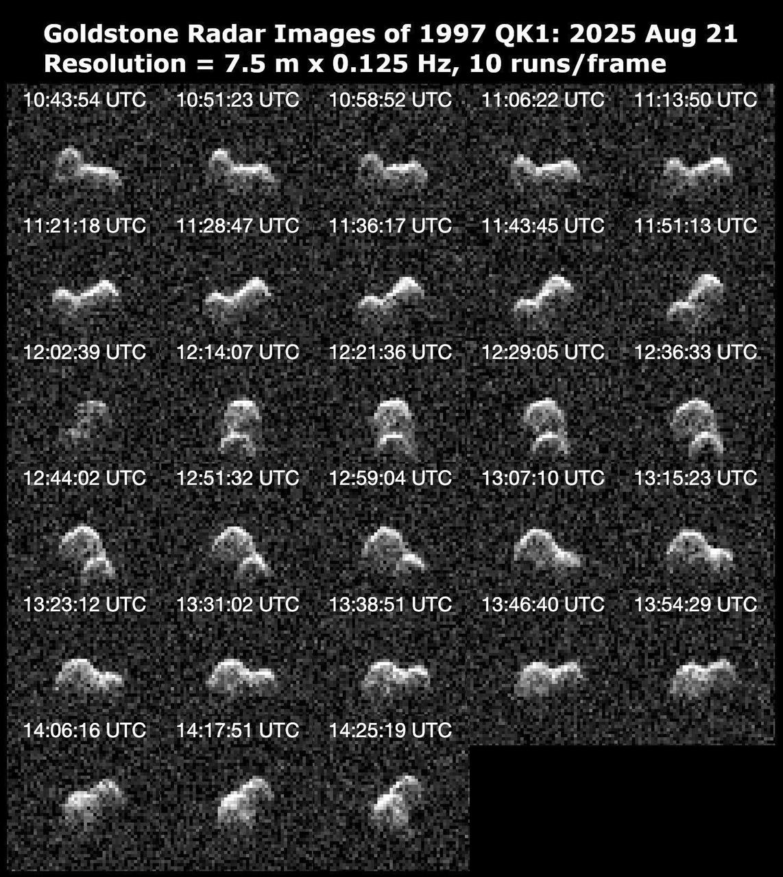
Asteroid 1997 QK1 is shown to be an elongated, peanut-shaped near-Earth object in this series of 28 radar images obtained by the Deep Space Network's Goldstone Solar System Radar on Aug. 21, 2025. The asteroid is about 660 feet (200 meters) long and completes one rotation every 4.8 hours. It passed closest to our planet on the day before these observations were made at a distance of about 1.9 million miles (3 million kilometers), or within eight times the distance between Earth and the Moon. The 2025 flyby is the closest that 1997 QK1 has approached to Earth in more than 350 years. Prior to the recent Goldstone observations, very little was known about the asteroid. These observations resolve surface features down to a resolution of about 25 feet (7.5 meters) and reveal that the object has two rounded lobes that are connected, with one lobe twice the size of the other. Both lobes appear to have concavities that are tens of meters deep. Asteroid 1997 QK1 is likely a "contact binary," one of dozens of such objects imaged by Goldstone. At least 15% of near-Earth asteroids larger than about 660 feet (200 meters) have a contact binary shape. The asteroid is classified as potentially hazardous, but it does not pose a hazard to Earth for the foreseeable future. These Goldstone measurements have greatly reduced the uncertainties in the asteroid's distance from Earth and in its future motion for many decades. The Goldstone Solar System Radar Group is supported by NASA's Near-Earth Object Observations Program within the Planetary Defense Coordination Office at the agency's headquarters in Washington. Managed by NASA's Jet Propulsion Laboratory, the Deep Space Network receives programmatic oversight from Space Communications and Navigation program office within the Space Operations Mission Directorate, also at NASA Headquarters. https://photojournal.jpl.nasa.gov/catalog/PIA26588
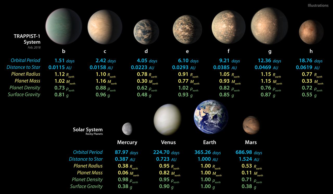
This chart shows, on the top row, artist concepts of the seven planets of TRAPPIST-1 with their orbital periods, distances from their star, radii, masses, densities and surface gravity as compared to those of Earth. These numbers are current as of February 2018. On the bottom row, the same numbers are displayed for the bodies of our inner solar system: Mercury, Venus, Earth and Mars. The TRAPPIST-1 planets orbit their star extremely closely, with periods ranging from 1.5 to only about 20 days. This is much shorter than the period of Mercury, which orbits our sun in about 88 days. The masses and densities of the TRAPPIST-1 planets were determined by careful measurements of slight variations in the timings of their orbits using extensive observations made by NASA's Spitzer and Kepler space telescopes, in combination with data from Hubble and a number of ground-based telescopes. These measurements are the most precise to date for any system of exoplanets. In this illustration, the relative sizes of the planets are all shown to scale. https://photojournal.jpl.nasa.gov/catalog/PIA22094

Of all the planets NASA has explored, none have matched the dynamic complexity of our own. Earth is constantly changing, and NASA are working constantly to explore and understand the planet on scales from local to global. Though Earth science has been a key part of NASA’s mission since the agency was founded in 1958, this year has been one of the peaks. Two new Earth-observing satellites have already been launched and put to work: the Global Precipitation Measurement (GPM) and the Orbiting Carbon Observatory 2 (OCO-2). Three more missions are set to take off in the next six months: the wind-measuring ISS-RapidScat, the ISS Cloud-Aerosol Transport System (CATS), and the Soil Moisture Active Passive (SMAP). And research planes have been flying over polar ice, hurricanes, boreal forests, and pollution plumes. All of these new efforts complement an existing fleet of Earth-observing satellites. In visible light and many invisible wavelengths, NASA and its science partners are observing the entire planet every day. The image above was captured on March 30, 2014, by the Visible Infrared Imaging Radiometer Suite (VIIRS) on the Suomi NPP satellite. The composite image of the eastern hemisphere was compiled from eight orbits of the satellite and ten imaging channels, then stitched together to blend the edges of each satellite pass. Read more: <a href="http://earthobservatory.nasa.gov/IOTD/view.php?id=84214&eocn=home&eoci=iotd_title" rel="nofollow">earthobservatory.nasa.gov/IOTD/view.php?id=84214&eocn...</a> NASA Earth Observatory image by Robert Simmon, using Suomi NPP VIIRS imagery from NOAA's Environmental Visualization Laboratory. Suomi NPP is the result of a partnership between NASA, NOAA and the Department of Defense. Caption by Mike Carlowicz. Credit: <b><a href="http://www.earthobservatory.nasa.gov/" rel="nofollow"> NASA Earth Observatory</a></b> <b><a href="http://www.nasa.gov/audience/formedia/features/MP_Photo_Guidelines.html" rel="nofollow">NASA image use policy.</a></b> <b><a href="http://www.nasa.gov/centers/goddard/home/index.html" rel="nofollow">NASA Goddard Space Flight Center</a></b> enables NASA’s mission through four scientific endeavors: Earth Science, Heliophysics, Solar System Exploration, and Astrophysics. Goddard plays a leading role in NASA’s accomplishments by contributing compelling scientific knowledge to advance the Agency’s mission. <b>Follow us on <a href="http://twitter.com/NASAGoddardPix" rel="nofollow">Twitter</a></b> <b>Like us on <a href="http://www.facebook.com/pages/Greenbelt-MD/NASA-Goddard/395013845897?ref=tsd" rel="nofollow">Facebook</a></b> <b>Find us on <a href="http://instagram.com/nasagoddard?vm=grid" rel="nofollow">Instagram</a></b>
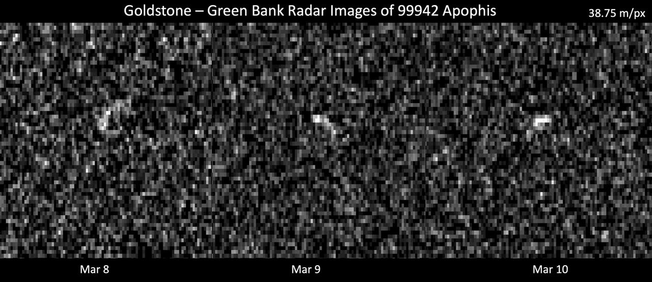
These images represent radar observations of asteroid 99942 Apophis on March 8, 9, and 10, 2021, as it made its last close approach before its 2029 Earth encounter that will see the object pass our planet by less than 20,000 miles (32,000 kilometers). The 70-meter radio antenna at the Deep Space Network's Goldstone Deep Space Communications Complex near Barstow, California, and the 100-meter Green Bank Telescope in West Virginia used radar to precisely track Apophis' motion. At the time of these observations, Apophis was about 10.6 million miles (17 million kilometers) from Earth, and each pixel has a resolution of 127 feet (38.75 meters). These observations helped scientists of the Center for Near Earth Object Studies (CNEOS), managed by NASA's Jet Propulsion Laboratory, precisely determine the 1,100-feet-wide (340-meter-wide) asteroid's orbit around the Sun, ruling out any Earth impact threat for the next hundred years or more. As a result of these observations, Apophis was removed from the Sentry Impact Risk Table. The radar team will continue to analyze these observations to determine more information about Apophis' size, shape, and rate of spin. Relying on optical telescopes and ground-based radar to help characterize every near-Earth object's orbit to improve long-term hazard assessments, CNEOS computes high-precision orbits in support of NASA's Planetary Defense Coordination Office. https://photojournal.jpl.nasa.gov/catalog/PIA24168
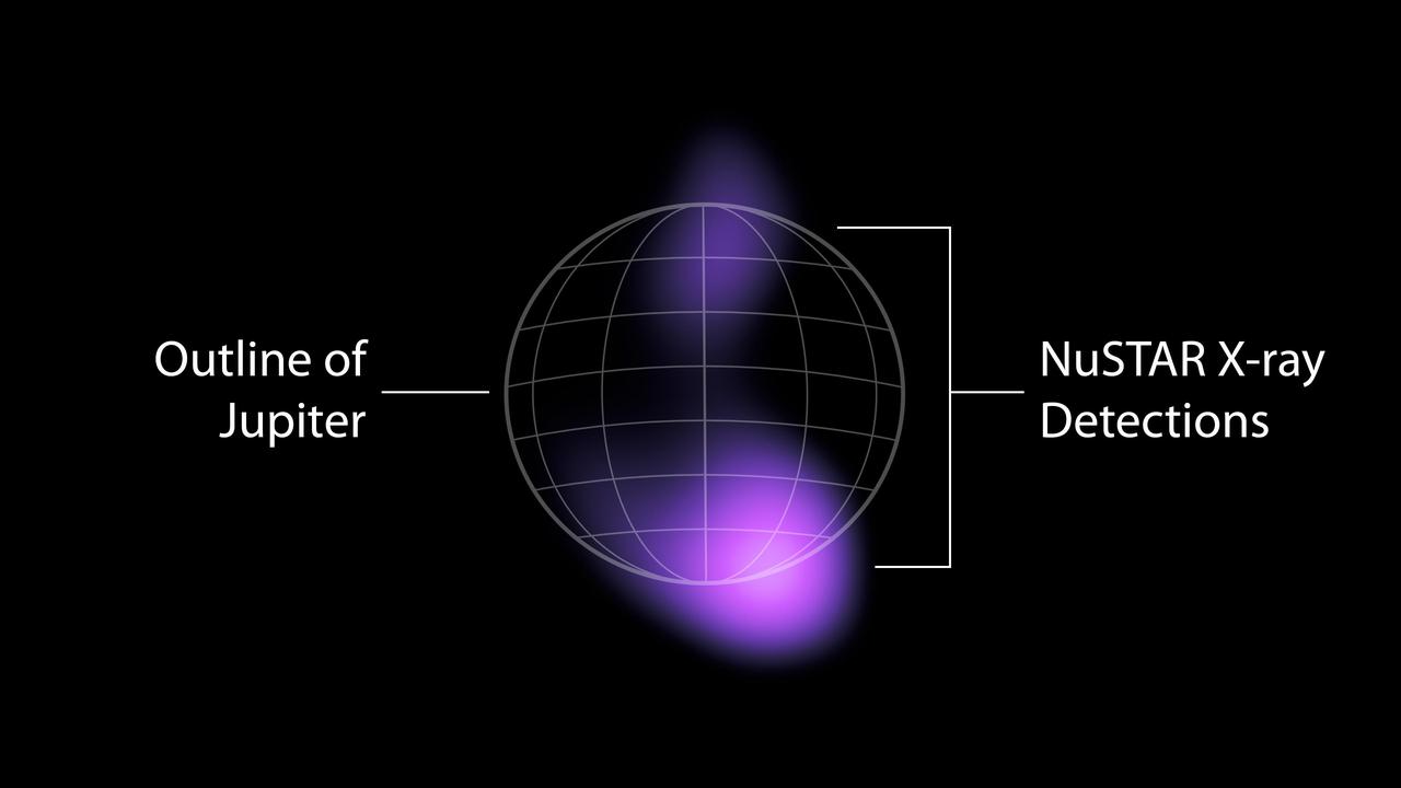
The areas where high-energy X-rays were detected by NASA's NuSTAR (Nuclear Spectroscopic Telescope Array) from the auroras near Jupiter's north and south poles are shown in purple in this graphic. The emissions are the highest-energy light ever seen at Jupiter and the highest-energy light ever detected from a planet in our solar system other than Earth. The light comes from accelerated electrons colliding with the atmosphere. NuSTAR cannot pinpoint the source of the light with high precision, but can only find that it is coming from somewhere in the purple-colored regions. X-rays are a form of light, but with much higher energies and shorter wavelengths than the visible light human eyes can see. NASA's Chandra X-ray Observatory and the ESA (European Space Agency) XMM-Newton observatory have both studied X-rays from Jupiter's auroras – produced when volcanos on Jupiter's moon Io shower the planet with ions (atoms stripped of their electrons). Jupiter's powerful magnetic field accelerates the particles and funnels them toward the planet's poles, where they collide with its atmosphere and release energy in the form of light, including X-rays. Electrons from Io are also accelerated by the planet's magnetic field, according to observations by the Jovian Auroral Distributions Experiment (JADE) and Jupiter Energetic-particle Detector Instrument (JEDI) on NASA's Juno spacecraft, which arrived at Jupiter in 2016. Researchers suspected that those electrons should produce even higher-energy X-rays than those observed by Chandra and XMM-Newton, and the NuSTAR detections confirm that hypothesis. The high-energy X-rays are relatively faint, and required a week of NuSTAR observations to detect. Scientists have detected X-rays in Earth's auroras with even higher energies than what NuSTAR saw at Jupiter, but those emissions can only be spotted by small satellites or high-altitude balloons that get extremely close to the locations in the atmosphere that generate those X-rays. https://photojournal.jpl.nasa.gov/catalog/PIA25131
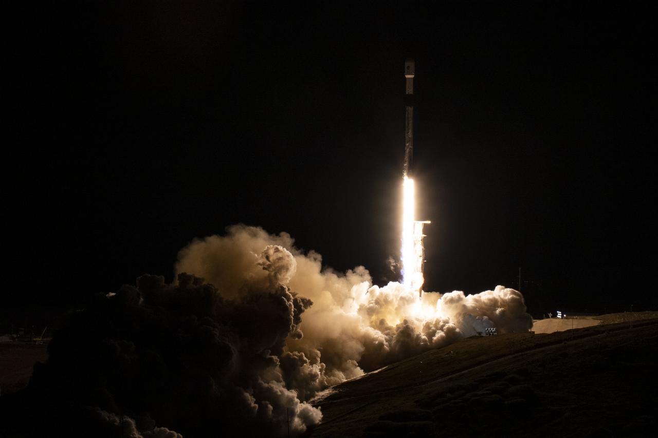
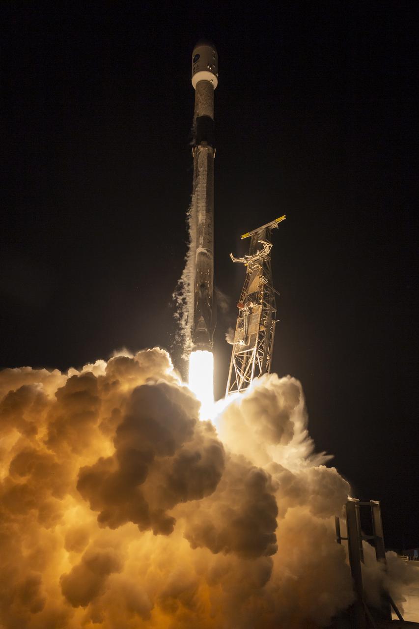
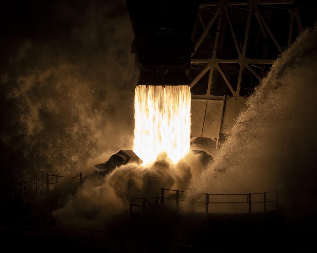
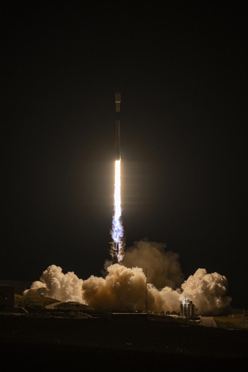
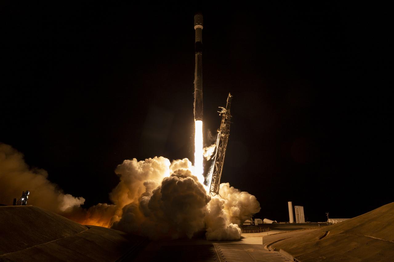
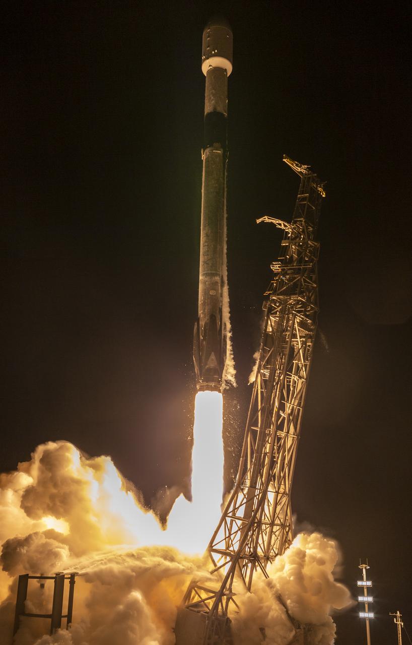
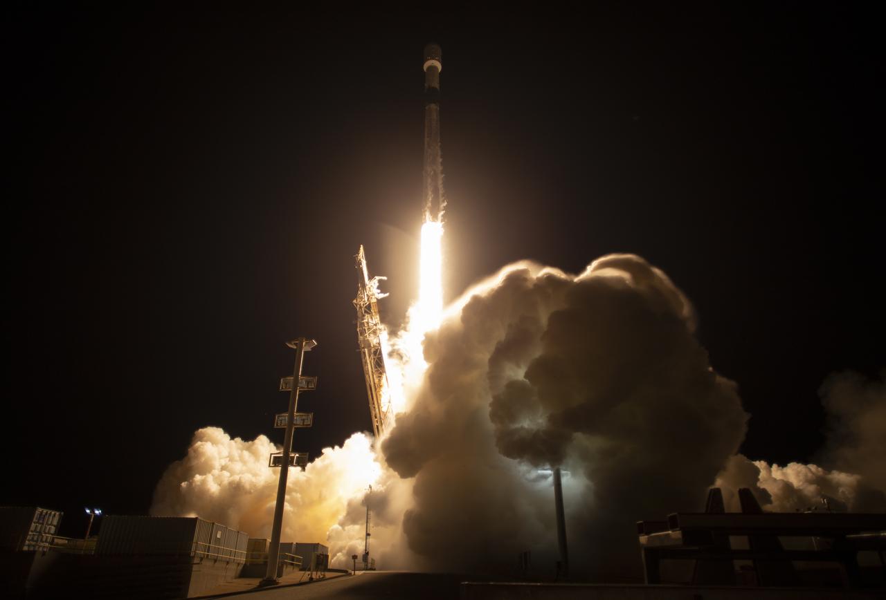
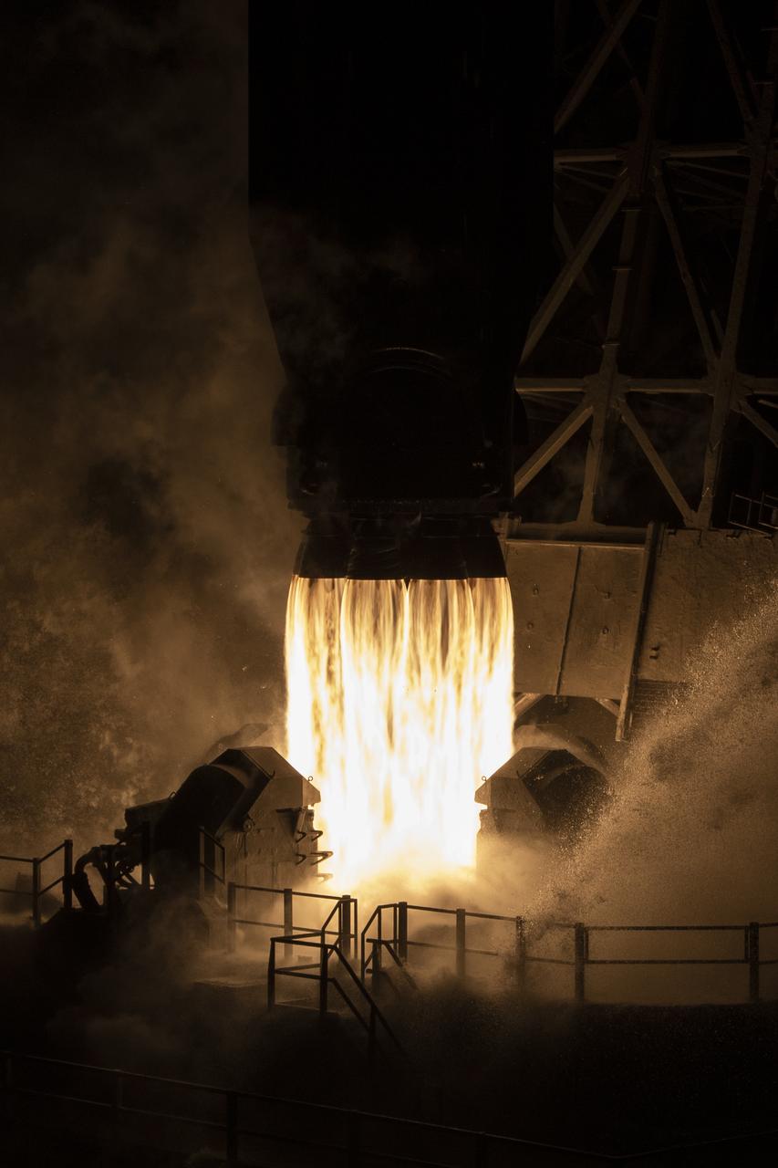
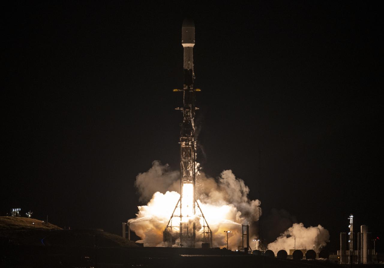
A SpaceX Falcon 9 rocket launches with the Surface Water and Ocean Topography (SWOT) spacecraft onboard, Friday, Dec. 16, 2022, from Space Launch Complex 4E at Vandenberg Space Force Base in California. Jointly developed by NASA and Centre National D'Etudes Spatiales (CNES), with contributions from the Canadian Space Agency (CSA) and United Kingdom Space Agency, SWOT is the first satellite mission that will observe nearly all water on Earth’s surface, measuring the height of water in the planet’s lakes, rivers, reservoirs, and the ocean. Photo Credit: (NASA/Keegan Barber)
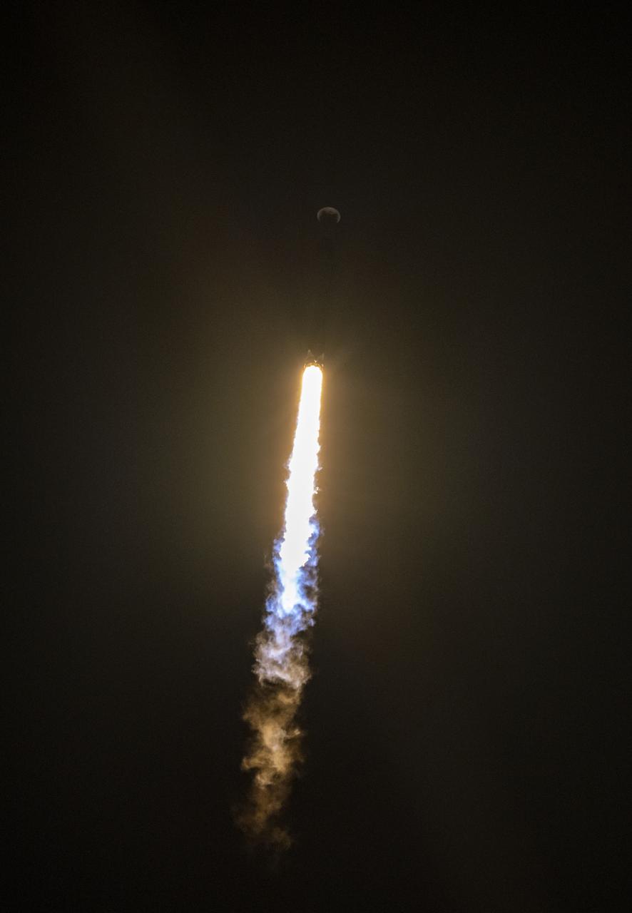
A SpaceX Falcon 9 rocket launches with the Surface Water and Ocean Topography (SWOT) spacecraft onboard, Friday, Dec. 16, 2022, from Space Launch Complex 4E at Vandenberg Space Force Base in California. Jointly developed by NASA and Centre National D'Etudes Spatiales (CNES), with contributions from the Canadian Space Agency (CSA) and United Kingdom Space Agency, SWOT is the first satellite mission that will observe nearly all water on Earth’s surface, measuring the height of water in the planet’s lakes, rivers, reservoirs, and the ocean. Photo Credit: (NASA/Keegan Barber)

A SpaceX Falcon 9 rocket launches with the Surface Water and Ocean Topography (SWOT) spacecraft onboard, Friday, Dec. 16, 2022, from Space Launch Complex 4E at Vandenberg Space Force Base in California. Jointly developed by NASA and Centre National D'Etudes Spatiales (CNES), with contributions from the Canadian Space Agency (CSA) and United Kingdom Space Agency, SWOT is the first satellite mission that will observe nearly all water on Earth’s surface, measuring the height of water in the planet’s lakes, rivers, reservoirs, and the ocean. Photo Credit: (NASA/Keegan Barber)
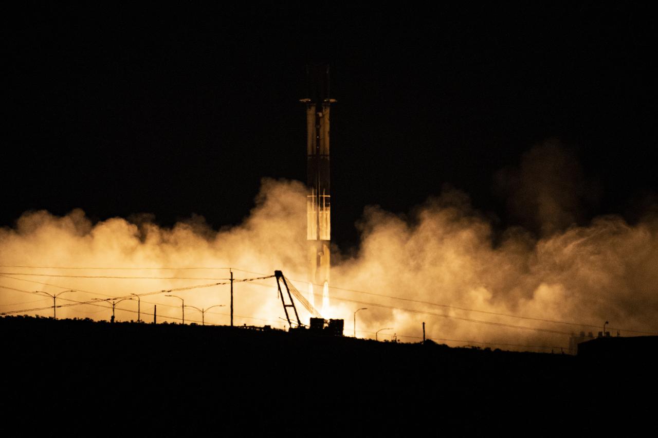
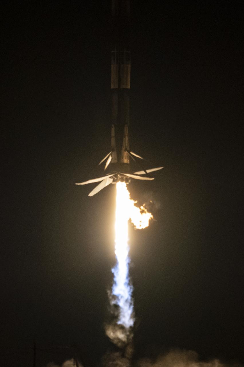
A SpaceX Falcon 9 first-stage booster returns to the landing pad following the launch of the Surface Water and Ocean Topography (SWOT) spacecraft, Friday, Dec. 16, 2022, from Space Launch Complex 4E at Vandenberg Space Force Base in California. Jointly developed by NASA and Centre National D'Etudes Spatiales (CNES), with contributions from the Canadian Space Agency (CSA) and United Kingdom Space Agency, SWOT is the first satellite mission that will observe nearly all water on Earth’s surface, measuring the height of water in the planet’s lakes, rivers, reservoirs, and the ocean. Photo Credit: (NASA/Keegan Barber)
A SpaceX Falcon 9 rocket launches with the Surface Water and Ocean Topography (SWOT) spacecraft onboard, Friday, Dec. 16, 2022, from Space Launch Complex 4E at Vandenberg Space Force Base in California. Jointly developed by NASA and Centre National D'Etudes Spatiales (CNES), with contributions from the Canadian Space Agency (CSA) and United Kingdom Space Agency, SWOT is the first satellite mission that will observe nearly all water on Earth’s surface, measuring the height of water in the planet’s lakes, rivers, reservoirs, and the ocean. Photo Credit: (NASA/Keegan Barber)
A SpaceX Falcon 9 rocket launches with the Surface Water and Ocean Topography (SWOT) spacecraft onboard, Friday, Dec. 16, 2022, from Space Launch Complex 4E at Vandenberg Space Force Base in California. Jointly developed by NASA and Centre National D'Etudes Spatiales (CNES), with contributions from the Canadian Space Agency (CSA) and United Kingdom Space Agency, SWOT is the first satellite mission that will observe nearly all water on Earth’s surface, measuring the height of water in the planet’s lakes, rivers, reservoirs, and the ocean. Photo Credit: (NASA/Keegan Barber)
A SpaceX Falcon 9 rocket launches with the Surface Water and Ocean Topography (SWOT) spacecraft onboard, Friday, Dec. 16, 2022, from Space Launch Complex 4E at Vandenberg Space Force Base in California. Jointly developed by NASA and Centre National D'Etudes Spatiales (CNES), with contributions from the Canadian Space Agency (CSA) and United Kingdom Space Agency, SWOT is the first satellite mission that will observe nearly all water on Earth’s surface, measuring the height of water in the planet’s lakes, rivers, reservoirs, and the ocean. Photo Credit: (NASA/Keegan Barber)
A SpaceX Falcon 9 rocket launches with the Surface Water and Ocean Topography (SWOT) spacecraft onboard, Friday, Dec. 16, 2022, from Space Launch Complex 4E at Vandenberg Space Force Base in California. Jointly developed by NASA and Centre National D'Etudes Spatiales (CNES), with contributions from the Canadian Space Agency (CSA) and United Kingdom Space Agency, SWOT is the first satellite mission that will observe nearly all water on Earth’s surface, measuring the height of water in the planet’s lakes, rivers, reservoirs, and the ocean. Photo Credit: (NASA/Keegan Barber)
A SpaceX Falcon 9 rocket launches with the Surface Water and Ocean Topography (SWOT) spacecraft onboard, Friday, Dec. 16, 2022, from Space Launch Complex 4E at Vandenberg Space Force Base in California. Jointly developed by NASA and Centre National D'Etudes Spatiales (CNES), with contributions from the Canadian Space Agency (CSA) and United Kingdom Space Agency, SWOT is the first satellite mission that will observe nearly all water on Earth’s surface, measuring the height of water in the planet’s lakes, rivers, reservoirs, and the ocean. Photo Credit: (NASA/Keegan Barber)

A SpaceX Falcon 9 rocket launches with the Surface Water and Ocean Topography (SWOT) spacecraft onboard, Friday, Dec. 16, 2022, from Space Launch Complex 4E at Vandenberg Space Force Base in California. Jointly developed by NASA and Centre National D'Etudes Spatiales (CNES), with contributions from the Canadian Space Agency (CSA) and United Kingdom Space Agency, SWOT is the first satellite mission that will observe nearly all water on Earth’s surface, measuring the height of water in the planet’s lakes, rivers, reservoirs, and the ocean. Photo Credit: (NASA/Keegan Barber)
A SpaceX Falcon 9 rocket launches with the Surface Water and Ocean Topography (SWOT) spacecraft onboard, Friday, Dec. 16, 2022, from Space Launch Complex 4E at Vandenberg Space Force Base in California. Jointly developed by NASA and Centre National D'Etudes Spatiales (CNES), with contributions from the Canadian Space Agency (CSA) and United Kingdom Space Agency, SWOT is the first satellite mission that will observe nearly all water on Earth’s surface, measuring the height of water in the planet’s lakes, rivers, reservoirs, and the ocean. Photo Credit: (NASA/Keegan Barber)
A SpaceX Falcon 9 first-stage booster returns to the landing pad following the launch of the Surface Water and Ocean Topography (SWOT) spacecraft, Friday, Dec. 16, 2022, from Space Launch Complex 4E at Vandenberg Space Force Base in California. Jointly developed by NASA and Centre National D'Etudes Spatiales (CNES), with contributions from the Canadian Space Agency (CSA) and United Kingdom Space Agency, SWOT is the first satellite mission that will observe nearly all water on Earth’s surface, measuring the height of water in the planet’s lakes, rivers, reservoirs, and the ocean. Photo Credit: (NASA/Keegan Barber)
A SpaceX Falcon 9 rocket launches with the Surface Water and Ocean Topography (SWOT) spacecraft onboard, Friday, Dec. 16, 2022, from Space Launch Complex 4E at Vandenberg Space Force Base in California. Jointly developed by NASA and Centre National D'Etudes Spatiales (CNES), with contributions from the Canadian Space Agency (CSA) and United Kingdom Space Agency, SWOT is the first satellite mission that will observe nearly all water on Earth’s surface, measuring the height of water in the planet’s lakes, rivers, reservoirs, and the ocean. Photo Credit: (NASA/Keegan Barber)
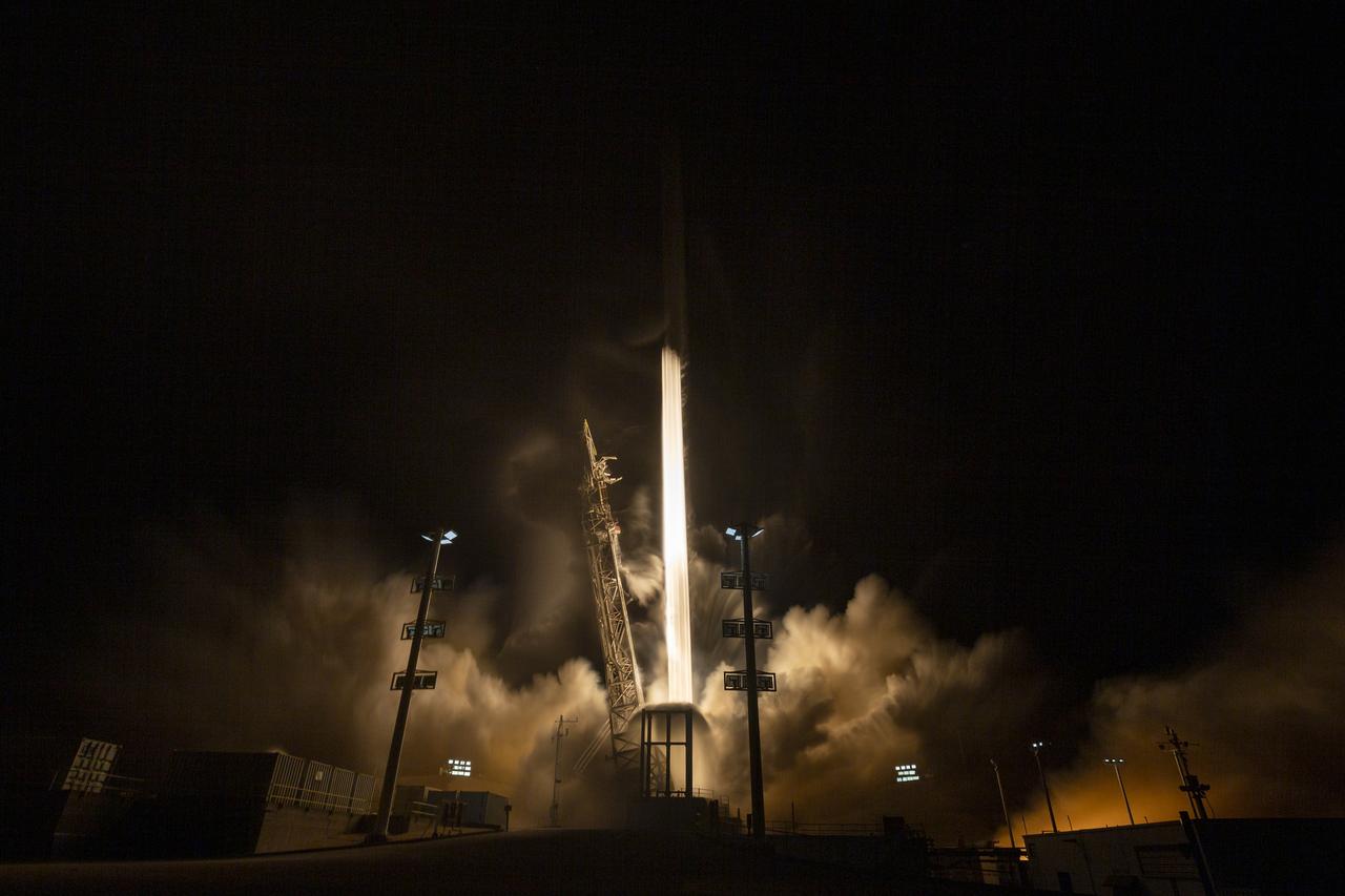
In this 30 second exposure, A SpaceX Falcon 9 rocket launches with the Surface Water and Ocean Topography (SWOT) spacecraft onboard, Friday, Dec. 16, 2022, from Space Launch Complex 4E at Vandenberg Space Force Base in California. Jointly developed by NASA and Centre National D'Etudes Spatiales (CNES), with contributions from the Canadian Space Agency (CSA) and United Kingdom Space Agency, SWOT is the first satellite mission that will observe nearly all water on Earth’s surface, measuring the height of water in the planet’s lakes, rivers, reservoirs, and the ocean. Photo Credit: (NASA/Keegan Barber)

A SpaceX Falcon 9 rocket launches with the Surface Water and Ocean Topography (SWOT) spacecraft onboard, Friday, Dec. 16, 2022, from Space Launch Complex 4E at Vandenberg Space Force Base in California. Jointly developed by NASA and Centre National D'Etudes Spatiales (CNES), with contributions from the Canadian Space Agency (CSA) and United Kingdom Space Agency, SWOT is the first satellite mission that will observe nearly all water on Earth’s surface, measuring the height of water in the planet’s lakes, rivers, reservoirs, and the ocean. Photo Credit: (NASA/Keegan Barber)
A SpaceX Falcon 9 rocket launches with the Surface Water and Ocean Topography (SWOT) spacecraft onboard, Friday, Dec. 16, 2022, from Space Launch Complex 4E at Vandenberg Space Force Base in California. Jointly developed by NASA and Centre National D'Etudes Spatiales (CNES), with contributions from the Canadian Space Agency (CSA) and United Kingdom Space Agency, SWOT is the first satellite mission that will observe nearly all water on Earth’s surface, measuring the height of water in the planet’s lakes, rivers, reservoirs, and the ocean. Photo Credit: (NASA/Keegan Barber)

The Surface Water and Ocean Topography (SWOT) spacecraft is transported from Astrotech to the SpaceX facility at Vandenberg Space Force Base in California on Nov. 21, 2022. SWOT is the first mission that will observe nearly all water on Earth’s surface, measuring the height of water in the planet’s lakes, rivers, reservoirs, and the ocean. The satellite is set to launch aboard a SpaceX Falcon 9 rocket in December from Vandenberg’s Space Launch Center-4 East. NASA’s Launch Services Program, based at the agency’s Kennedy Space Center in Florida, is managing the launch service.

The Surface Water and Ocean Topography (SWOT) spacecraft is transported from Astrotech to the SpaceX facility at Vandenberg Space Force Base in California on Nov. 21, 2022. SWOT is the first mission that will observe nearly all water on Earth’s surface, measuring the height of water in the planet’s lakes, rivers, reservoirs, and the ocean. The satellite is set to launch aboard a SpaceX Falcon 9 rocket in December from Vandenberg’s Space Launch Center-4 East. NASA’s Launch Services Program, based at the agency’s Kennedy Space Center in Florida, is managing the launch service.
The Surface Water and Ocean Topography (SWOT) spacecraft is transported from Astrotech to the SpaceX facility at Vandenberg Space Force Base in California on Nov. 21, 2022. SWOT is the first mission that will observe nearly all water on Earth’s surface, measuring the height of water in the planet’s lakes, rivers, reservoirs, and the ocean. The satellite is set to launch aboard a SpaceX Falcon 9 rocket in December from Vandenberg’s Space Launch Center-4 East. NASA’s Launch Services Program, based at the agency’s Kennedy Space Center in Florida, is managing the launch service.
The Surface Water and Ocean Topography (SWOT) spacecraft is transported from Astrotech to the SpaceX facility at Vandenberg Space Force Base in California on Nov. 21, 2022. SWOT is the first mission that will observe nearly all water on Earth’s surface, measuring the height of water in the planet’s lakes, rivers, reservoirs, and the ocean. The satellite is set to launch aboard a SpaceX Falcon 9 rocket in December from Vandenberg’s Space Launch Center-4 East. NASA’s Launch Services Program, based at the agency’s Kennedy Space Center in Florida, is managing the launch service.
The Surface Water and Ocean Topography (SWOT) spacecraft is transported from Astrotech to the SpaceX facility at Vandenberg Space Force Base in California on Nov. 21, 2022. SWOT is the first mission that will observe nearly all water on Earth’s surface, measuring the height of water in the planet’s lakes, rivers, reservoirs, and the ocean. The satellite is set to launch aboard a SpaceX Falcon 9 rocket in December from Vandenberg’s Space Launch Center-4 East. NASA’s Launch Services Program, based at the agency’s Kennedy Space Center in Florida, is managing the launch service.
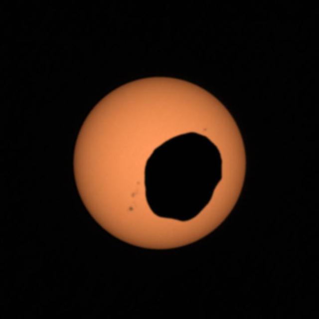
NASA's Perseverance Mars rover used its Mastcam-Z camera system to shoot video of Phobos, one of Mars' two moons, eclipsing the Sun. It's the most zoomed-in, highest-frame-rate observation of a Phobos solar eclipse ever taken from the Martian surface. Several Mars rovers have observed Phobos crossing in front of the Sun over the past 18 years. Spirit and Opportunity made the first observations in 2004; Curiosity in 2019 was the first to record video of the event. Each time these eclipses are observed, they allow scientists to measure subtle shifts in Phobos' orbit over time. The moon's tidal forces pull on the deep interior crust and mantle of the Red Planet; studying how much Phobos shifts over time reveals something about how resistant the crust and mantle are, and thus what kinds of materials they're made of. It's long been known that Phobos is drifting toward the Martian surface year by year; tens of millions of years from now, it is expected to crash into the planet or fragment into chunks that will impact the planet. Studying Phobos' orbit also allows scientists to refine predictions of when the doomed moon will crash into Mars. A key objective for Perseverance's mission on Mars is astrobiology, including the search for signs of ancient microbial life. The rover will characterize the planet's geology and past climate, pave the way for human exploration of the Red Planet, and be the first mission to collect and cache Martian rock and regolith (broken rock and dust). Subsequent NASA missions, in cooperation with ESA (European Space Agency), would send spacecraft to Mars to collect these sealed samples from the surface and return them to Earth for in-depth analysis. The Mars 2020 Perseverance mission is part of NASA's Moon to Mars exploration approach, which includes Artemis missions to the Moon that will help prepare for human exploration of the Red Planet. Movie available at https://photojournal.jpl.nasa.gov/catalog/PIA25179
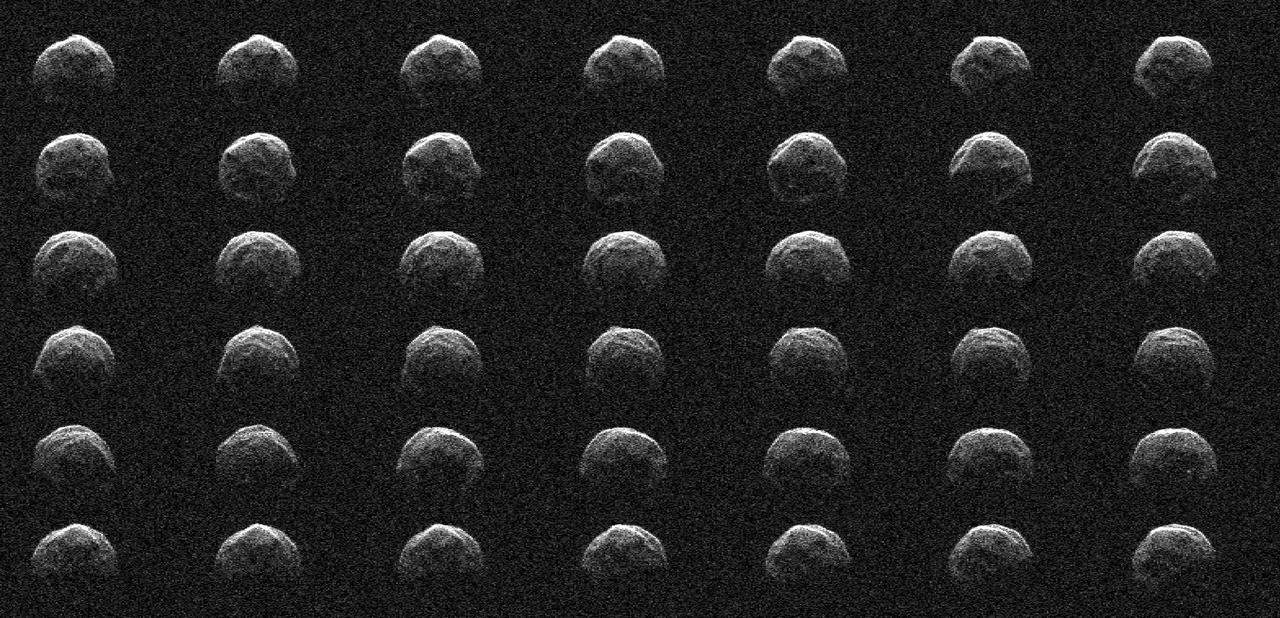
This collage represents a selection of NASA radar observations of near-Earth asteroid 2006 HV5 on April 25, 2023, less than one day before its close approach with our planet at a distance of about 1.5 million miles (2.4 million kilometers, or about 6.3 times the distance between the Moon and Earth). Asteroid 2006 HV5 was discovered by the Lincoln Near-Earth Asteroid Research (LINEAR) program in New Mexico in April 2006. The radar images show that 2006 HV5 is about 1,000 feet (300 meters) across, roughly the height of the Eiffel Tower, confirming size estimates derived from infrared observations made previously by NASA's NEOWISE mission. 2006 HV5 is classified as a potentially hazardous asteroid as its orbit brings it close to Earth, but its path around the Sun is very well known and the asteroid is not an impact risk to our planet. Asteroids of this size come this close to Earth roughly once a year, on average. The new observations were made by scientists at NASA's Jet Propulsion Laboratory using the powerful 230-foot (70-meter) Goldstone Solar System Radar antenna at the Deep Space Network's facility near Barstow, California. The images confirm the asteroid's size, while also providing a detailed look at its meatball-like shape. The asteroid has a rounded appearance, is "squished" at the poles (i.e., it is oblate), and has a rotation period of about 3.6 hours. The sequence of radar images spans slightly more than one rotation. The images, which have a resolution of about 12 feet (3.75 meters) per pixel, reveal surface features such as ridges, flat regions, concavities, and small-scale topography that might indicate boulders. https://photojournal.jpl.nasa.gov/catalog/PIA25834
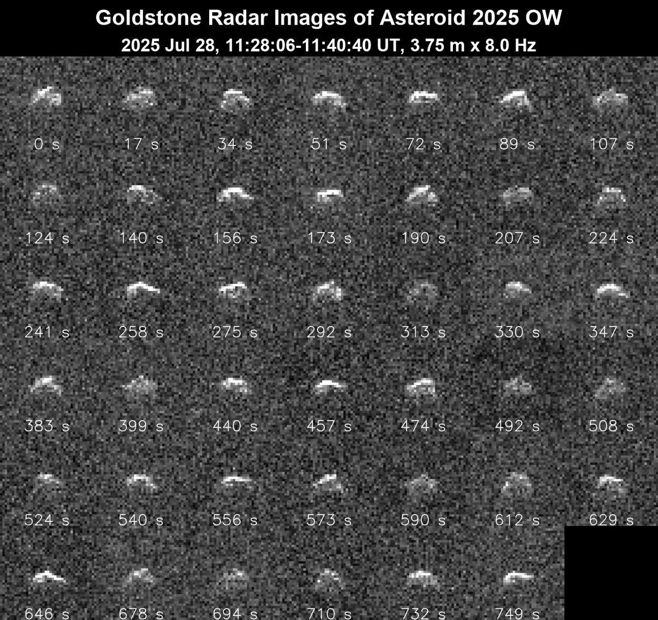
This series of 41 radar images obtained by the Deep Space Network's Goldstone Solar System Radar on July 28, 2025, shows the near-Earth asteroid 2025 OW as it made its close approach with our planet. The asteroid safely passed at about 400,000 miles (640,000 kilometers), or 1.6 times the distance from Earth to the Moon. The asteroid was discovered on July 4, 2025, by the NASA-funded Pan-STARRS2 survey telescope on Haleakala in Maui, Hawaii. These Goldstone observations suggest that 2025 OW is about 200 feet (60 meters) wide and has an irregular shape. The observations also indicate that it is rapidly spinning, completing one rotation every 1½ to 3 minutes, making it one of the fastest-spinning near-Earth asteroids that the powerful radar system has observed. The observations resolve surface features down to 12 feet (3.75 meters) wide. Asteroids can be "spun up" by sunlight being unevenly absorbed and re-emitted across their irregular surfaces. As photons (quantum particles of light) carry a tiny amount of momentum away from the asteroid, a tiny amount of torque is applied and, over time, the asteroid's spin can increase – a phenomenon known as the YORP effect. For 2025 OW to maintain such a fast rotation without breaking apart, it may be a solid object rather than a loosely bound rubble pile like many asteroids. The Goldstone measurements have allowed scientists to greatly reduce uncertainties in the asteroid's distance from Earth and in its future motion for many decades. This July 28 close approach is the closest asteroid 2025 OW will come to Earth for the foreseeable future. Animation available at https://photojournal.jpl.nasa.gov/catalog/PIA26587
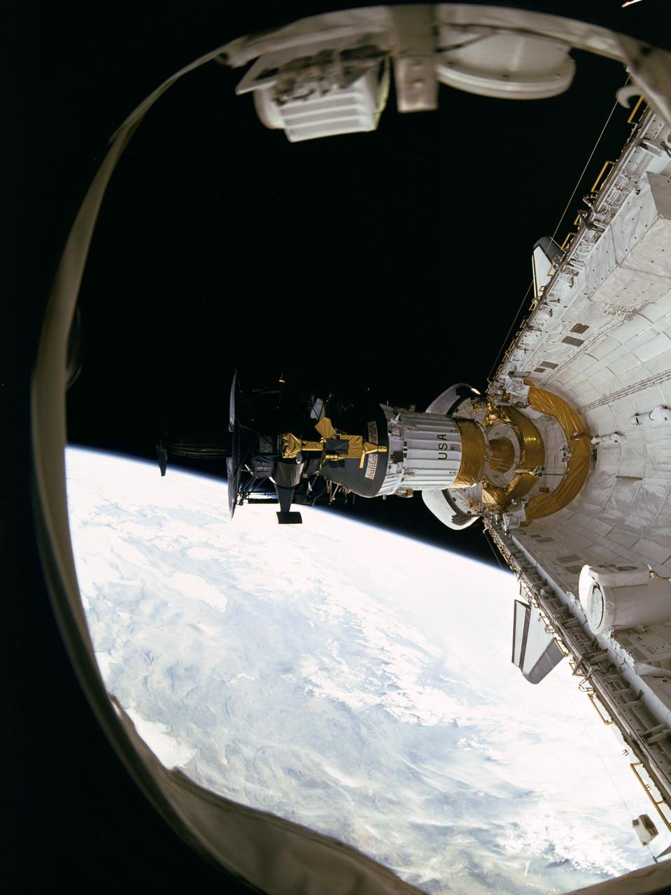
S89-48714 (18 Oct 1989) --- This photograph was taken by the STS-34 crew aboard the Space Shuttle Atlantis and shows the Galileo spacecraft being deployed on Oct. 18, 1989 from the payload bay. Galileo is a scientific craft that will go into orbit around the planet Jupiter and drop a probe into its atmosphere in search of primordial solar system material believed to be present there. The 70mm motion picture film will be used in the forthcoming "Blue Planet," which will address Earth's environmental problems from the perspective of space-based observation and solar system exploration. The film is being produced by IMAX Space Technology Inc. for the sponsor, the Smithsonian Institution, with funding provided by the Lockheed Corporation. PHOTO CREDIT: NASA/Smithsonian Institution
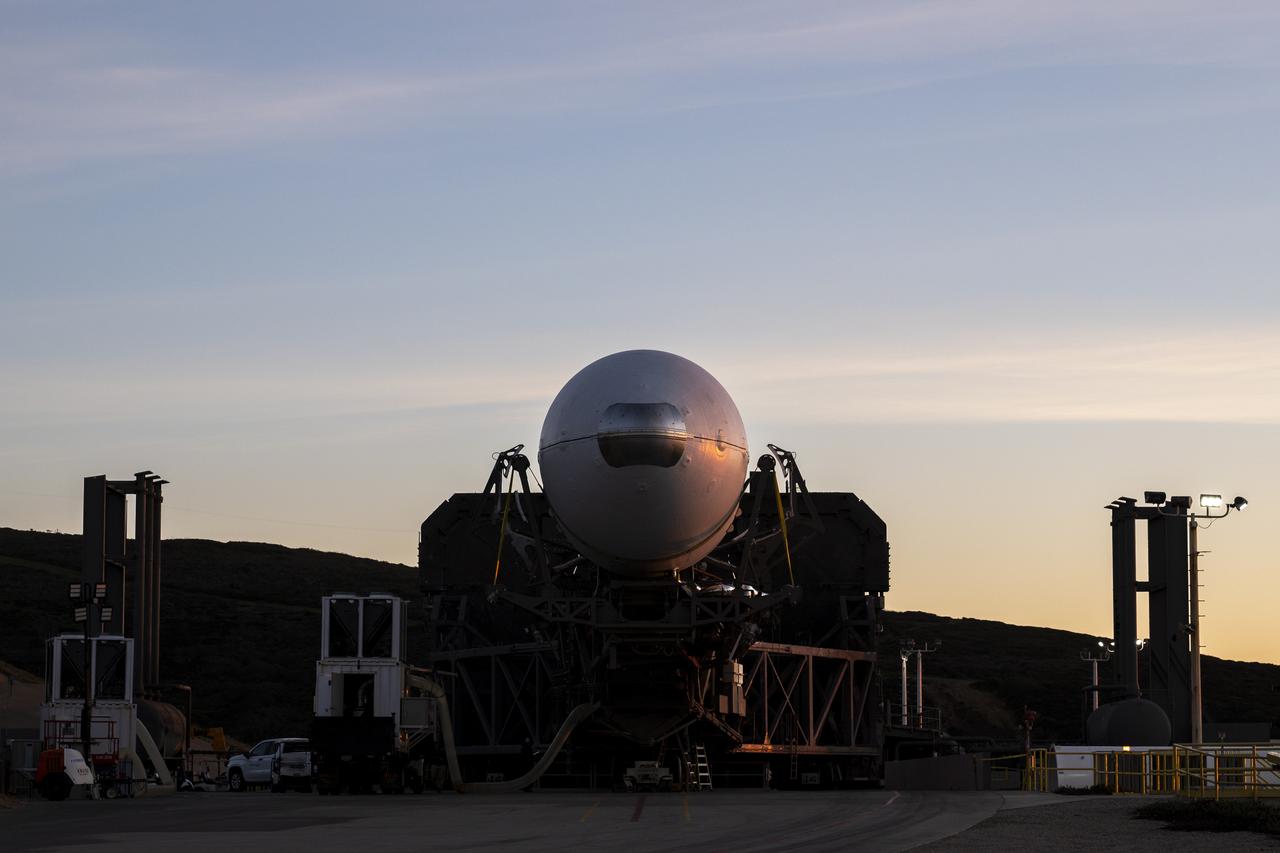
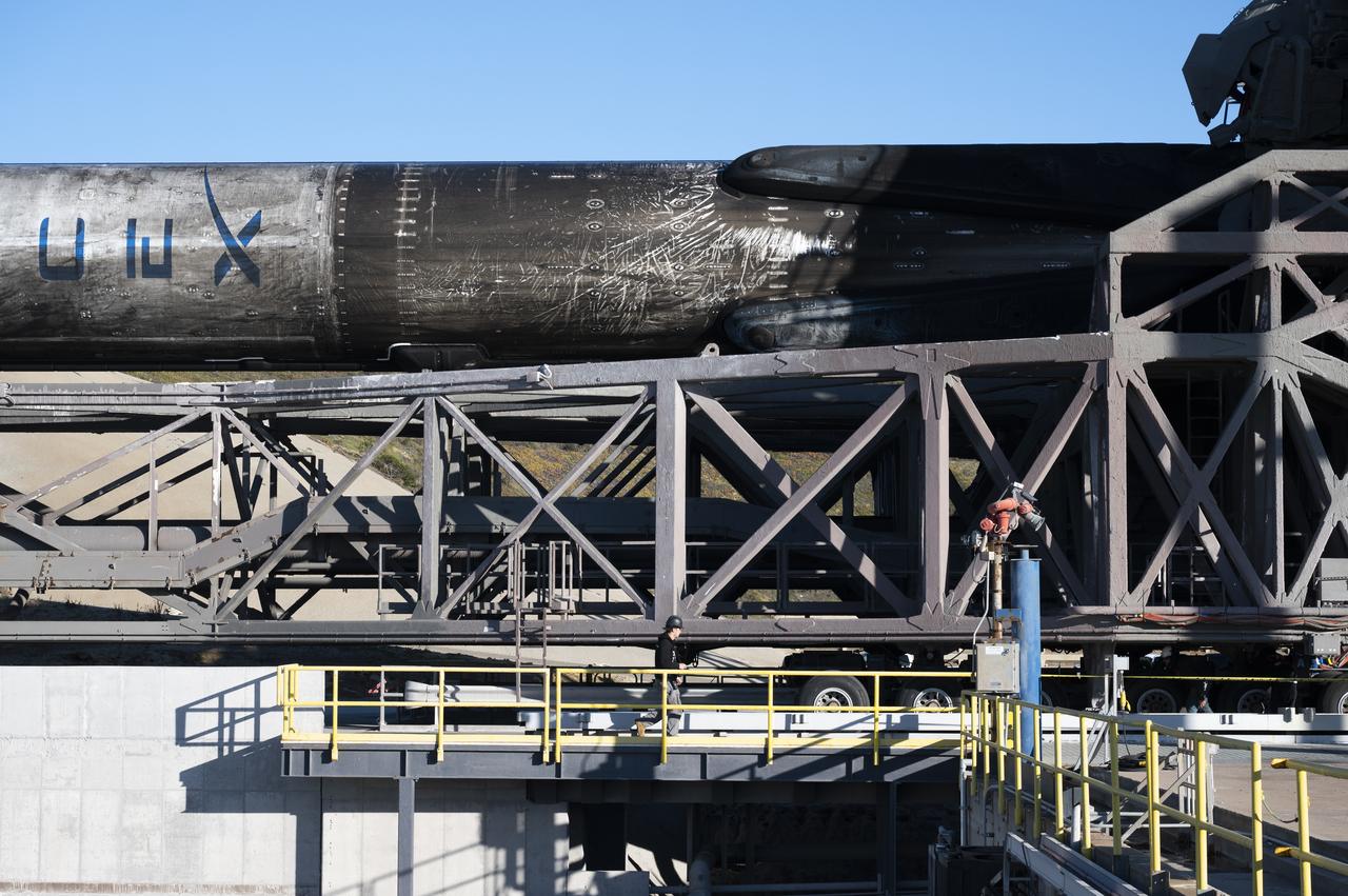
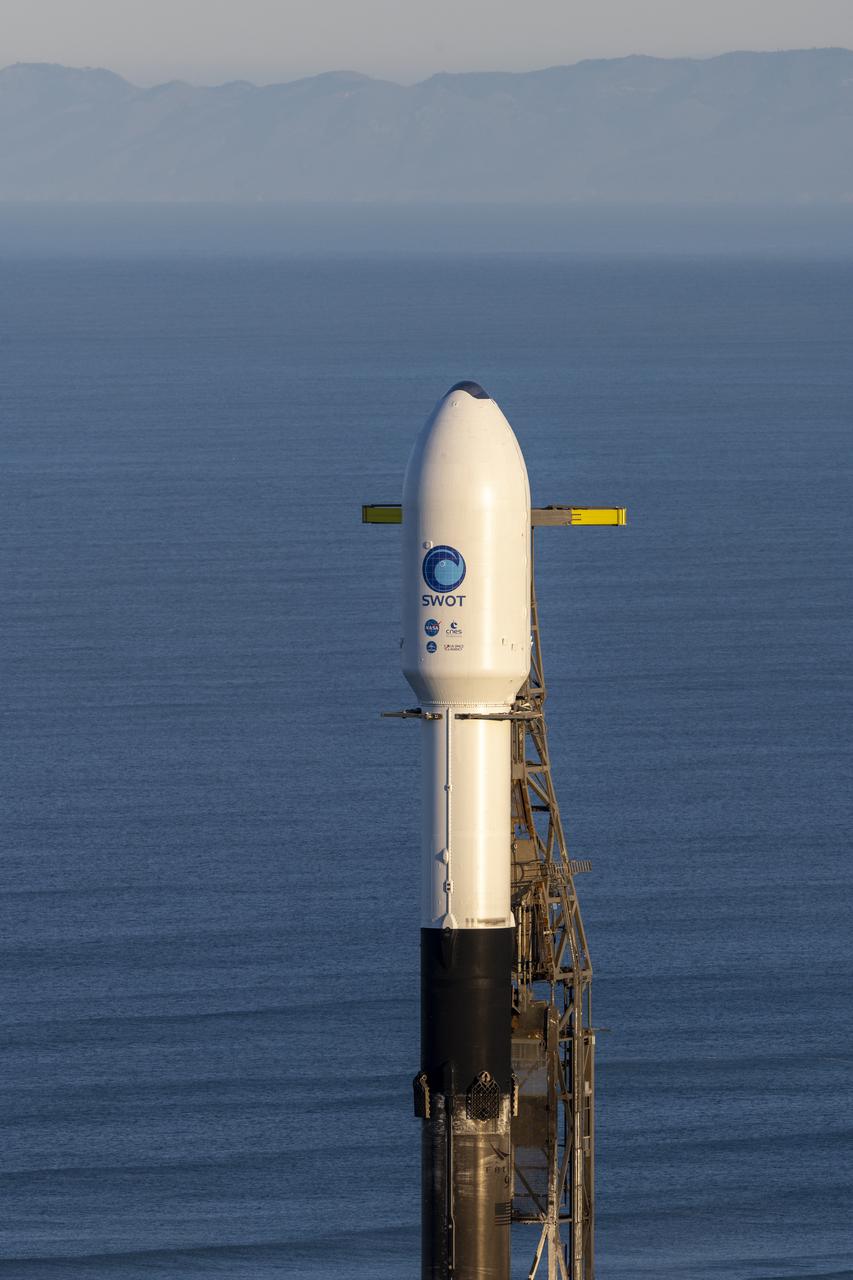
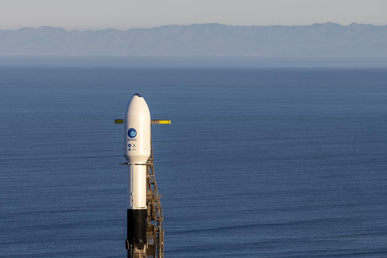
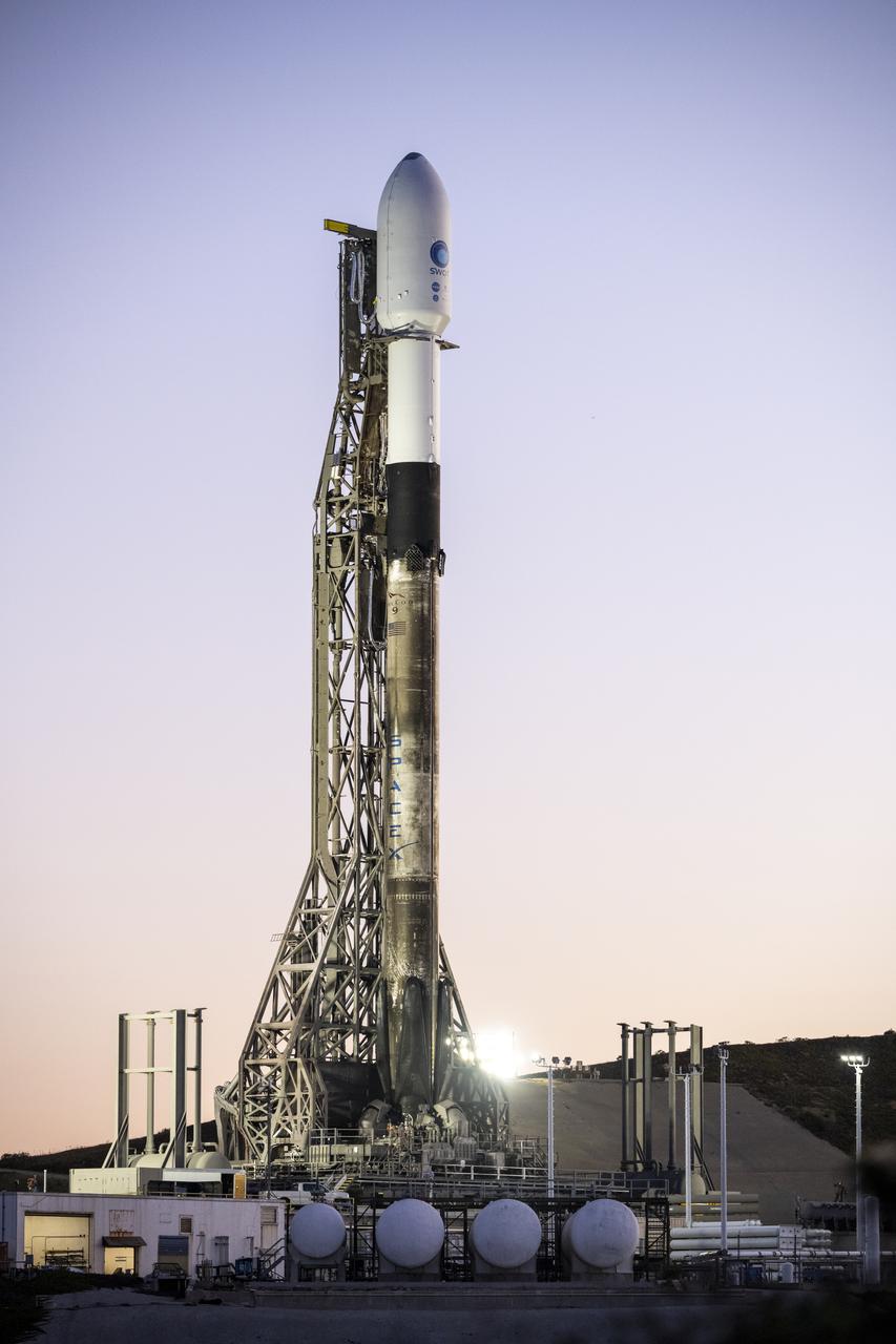
A SpaceX Falcon 9 rocket with the Surface Water and Ocean Topography (SWOT) spacecraft onboard is seen as it rolls out to the pad, Tuesday, Dec. 13, 2022, at Space Launch Complex 4E at Vandenberg Space Force Base in California. Jointly developed by NASA and Centre National D'Etudes Spatiales (CNES), with contributions from the Canadian Space Agency (CSA) and United Kingdom Space Agency, SWOT is the first satellite mission that will observe nearly all water on Earth’s surface, measuring the height of water in the planet’s lakes, rivers, reservoirs, and the ocean. Photo Credit: (NASA/Keegan Barber)
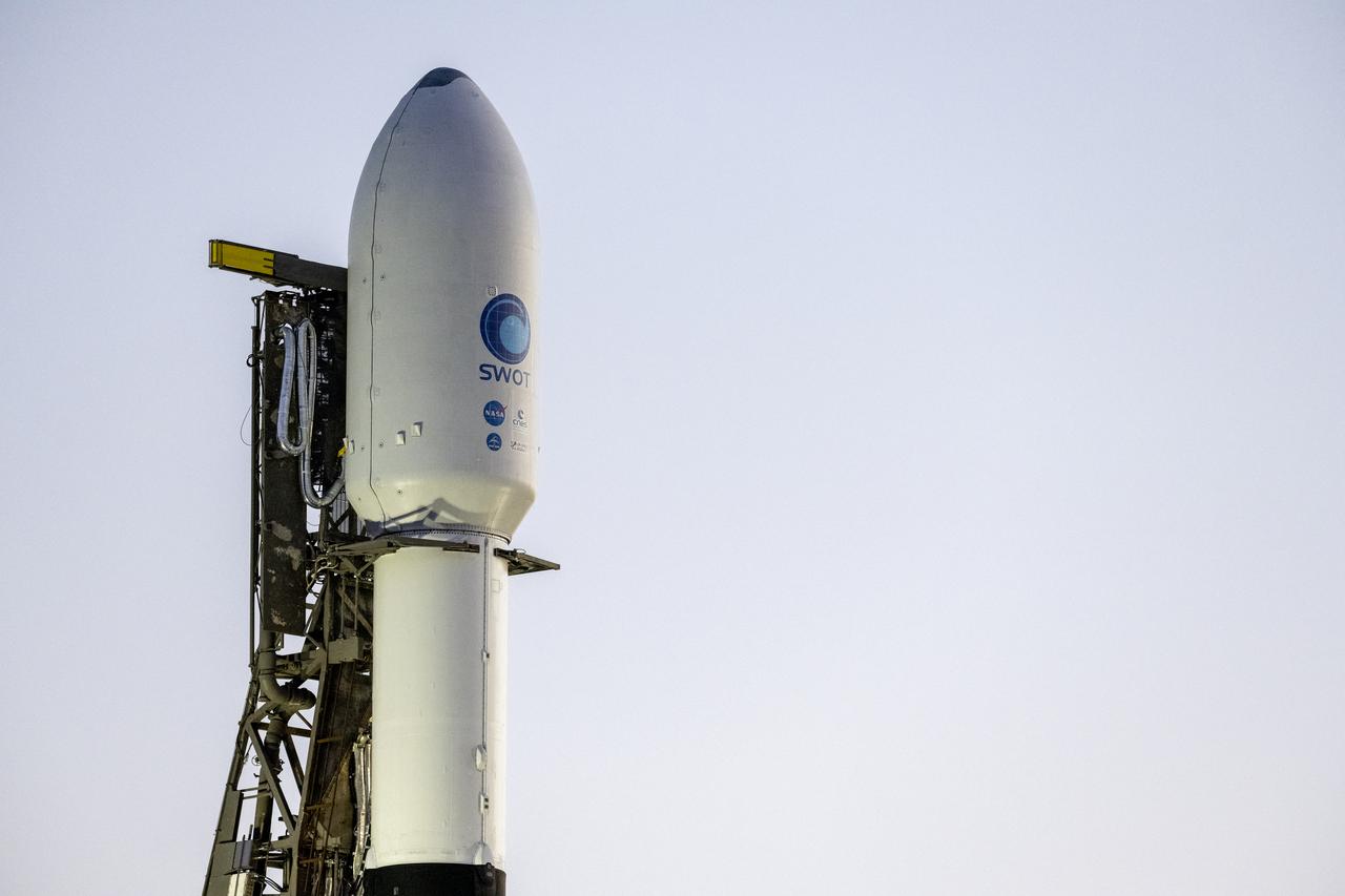
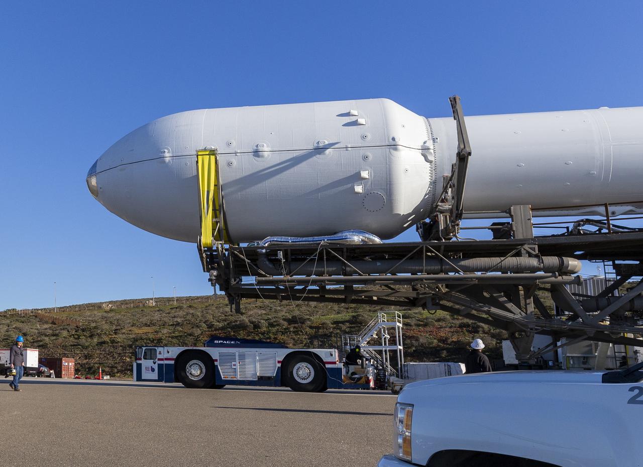
A SpaceX Falcon 9 rocket with the Surface Water and Ocean Topography (SWOT) spacecraft onboard is seen as preparations for launch continue, Wednesday, Dec. 14, 2022, at Space Launch Complex 4E at Vandenberg Space Force Base in California. Jointly developed by NASA and Centre National D'Etudes Spatiales (CNES), with contributions from the Canadian Space Agency (CSA) and United Kingdom Space Agency, SWOT is the first satellite mission that will observe nearly all water on Earth’s surface, measuring the height of water in the planet’s lakes, rivers, reservoirs, and the ocean. Photo Credit: (NASA/Keegan Barber)
A SpaceX Falcon 9 rocket with the Surface Water and Ocean Topography (SWOT) spacecraft onboard is seen as it rolls out to the pad, Tuesday, Dec. 13, 2022, at Space Launch Complex 4E at Vandenberg Space Force Base in California. Jointly developed by NASA and Centre National D'Etudes Spatiales (CNES), with contributions from the Canadian Space Agency (CSA) and United Kingdom Space Agency, SWOT is the first satellite mission that will observe nearly all water on Earth’s surface, measuring the height of water in the planet’s lakes, rivers, reservoirs, and the ocean. Photo Credit: (NASA/Keegan Barber)
A SpaceX Falcon 9 rocket with the Surface Water and Ocean Topography (SWOT) spacecraft onboard is seen as preparations for launch continue, Wednesday, Dec. 14, 2022, at Space Launch Complex 4E at Vandenberg Space Force Base in California. Jointly developed by NASA and Centre National D'Etudes Spatiales (CNES), with contributions from the Canadian Space Agency (CSA) and United Kingdom Space Agency, SWOT is the first satellite mission that will observe nearly all water on Earth’s surface, measuring the height of water in the planet’s lakes, rivers, reservoirs, and the ocean. Photo Credit: (NASA/Keegan Barber)
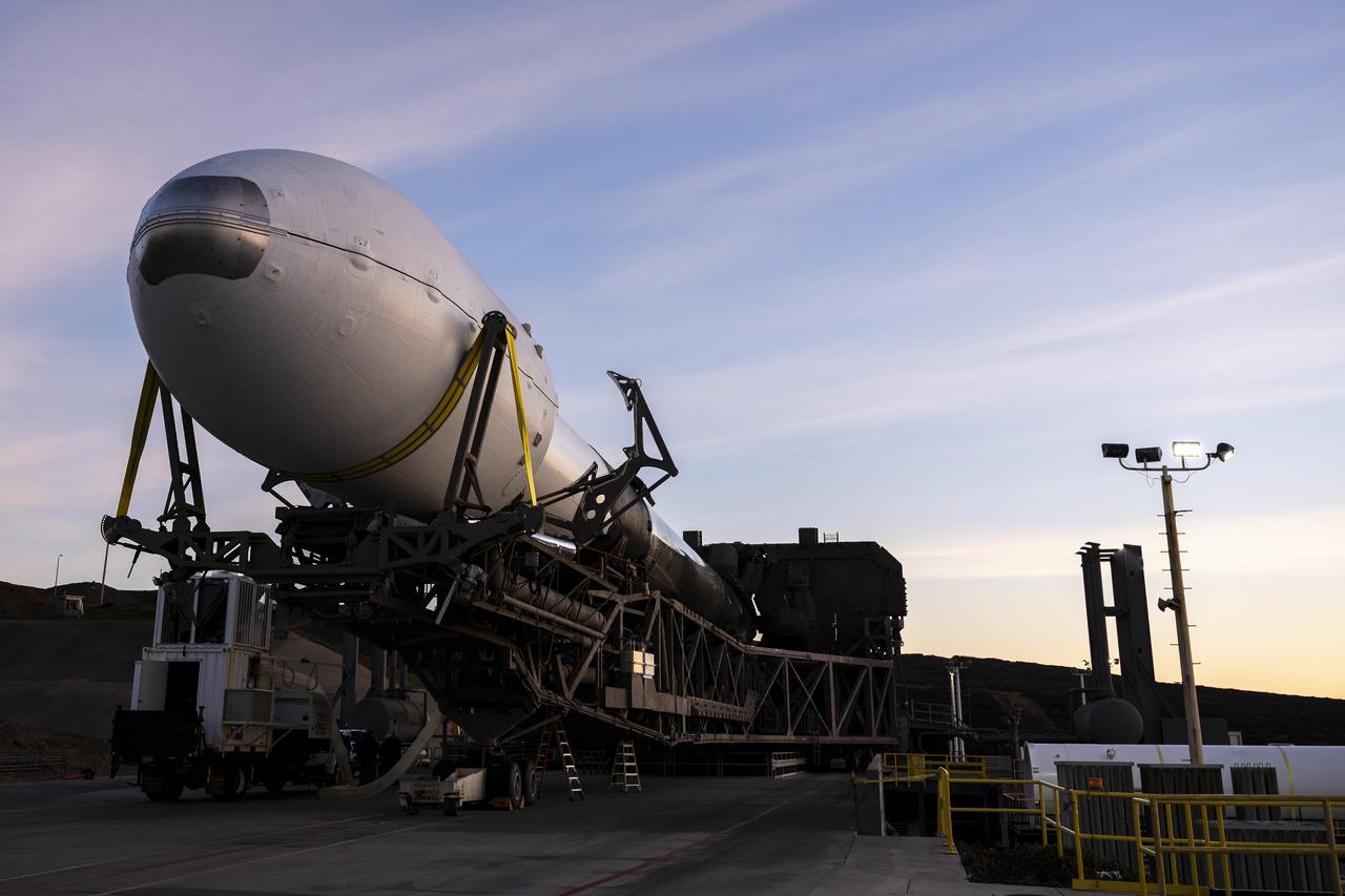
A SpaceX Falcon 9 rocket with the Surface Water and Ocean Topography (SWOT) spacecraft onboard is seen as it rolls out to the pad, Tuesday, Dec. 13, 2022, at Space Launch Complex 4E at Vandenberg Space Force Base in California. Jointly developed by NASA and Centre National D'Etudes Spatiales (CNES), with contributions from the Canadian Space Agency (CSA) and United Kingdom Space Agency, SWOT is the first satellite mission that will observe nearly all water on Earth’s surface, measuring the height of water in the planet’s lakes, rivers, reservoirs, and the ocean. Photo Credit: (NASA/Keegan Barber)
A SpaceX Falcon 9 rocket with the Surface Water and Ocean Topography (SWOT) spacecraft onboard is seen as it rolls out to the pad, Tuesday, Dec. 13, 2022, at Space Launch Complex 4E at Vandenberg Space Force Base in California. Jointly developed by NASA and Centre National D'Etudes Spatiales (CNES), with contributions from the Canadian Space Agency (CSA) and United Kingdom Space Agency, SWOT is the first satellite mission that will observe nearly all water on Earth’s surface, measuring the height of water in the planet’s lakes, rivers, reservoirs, and the ocean. Photo Credit: (NASA/Keegan Barber)
A SpaceX Falcon 9 rocket with the Surface Water and Ocean Topography (SWOT) spacecraft onboard is seen as preparations for launch continue, Wednesday, Dec. 14, 2022, at Space Launch Complex 4E at Vandenberg Space Force Base in California. Jointly developed by NASA and Centre National D'Etudes Spatiales (CNES), with contributions from the Canadian Space Agency (CSA) and United Kingdom Space Agency, SWOT is the first satellite mission that will observe nearly all water on Earth’s surface, measuring the height of water in the planet’s lakes, rivers, reservoirs, and the ocean. Photo Credit: (NASA/Keegan Barber)
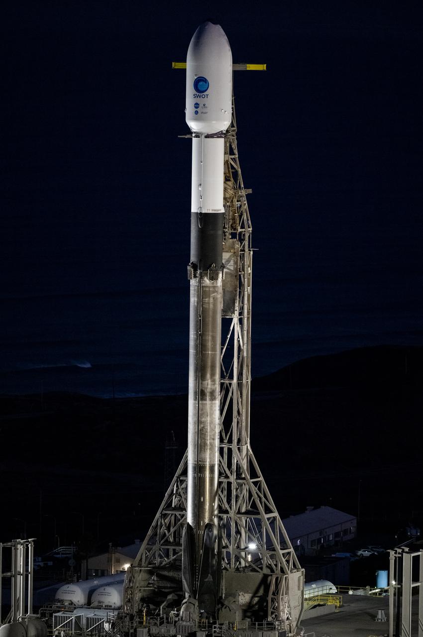
A SpaceX Falcon 9 rocket with the Surface Water and Ocean Topography (SWOT) spacecraft onboard is seen as preparations for launch continue, Wednesday, Dec. 14, 2022, at Space Launch Complex 4E at Vandenberg Space Force Base in California. Jointly developed by NASA and Centre National D'Etudes Spatiales (CNES), with contributions from the Canadian Space Agency (CSA) and United Kingdom Space Agency, SWOT is the first satellite mission that will observe nearly all water on Earth’s surface, measuring the height of water in the planet’s lakes, rivers, reservoirs, and the ocean. Photo Credit: (NASA/Keegan Barber)
A SpaceX Falcon 9 rocket with the Surface Water and Ocean Topography (SWOT) spacecraft onboard is seen as preparations for launch continue, Wednesday, Dec. 14, 2022, at Space Launch Complex 4E at Vandenberg Space Force Base in California. Jointly developed by NASA and Centre National D'Etudes Spatiales (CNES), with contributions from the Canadian Space Agency (CSA) and United Kingdom Space Agency, SWOT is the first satellite mission that will observe nearly all water on Earth’s surface, measuring the height of water in the planet’s lakes, rivers, reservoirs, and the ocean. Photo Credit: (NASA/Keegan Barber)