STS054-151-150 (13-19 Jan 1993) --- View west into sun glint off the Rio Salado, Saladillo, and Parana Rivers in Argentina. The Space Shuttle nadir is about 28 degrees north latitude and 57 degrees west longitude. The Andes Mountains are barely visible on Earth's limb. Thunderstorms along the eastern edge of the Andes are typical of this time of year (Southern Hemisphere summer), with anvils moving to the east from the core of the storm.

STS047-54-018 (12-20 Sept. 1992) --- The colors in this photograph provide insight into the relative density of the atmosphere. The crew members had many opportunities to witness sunrises and sunsets, considering they orbit the Earth every 90 minutes, but few, they said, compared to this scene. It captures the silhouette of several mature thunderstorms with their cirrus anvil tops spreading out against the tropopause (the top of the lowest layer of Earth's atmosphere) at sunset. The lowest layer (troposphere) is the densest and refracts light at the red end of the visible spectrum (7,400 Angstroms), while the blues (4,000 Angstroms) are separated in the least dense portion of the atmosphere (middle and upper atmosphere, or stratosphere and mesosphere). Several layers of blue can be seen. NASA scientists studying the photos believe this stratification to be caused by the scattering of light by particulate trapped in the stratosphere and mesosphere particulate that generally originate from volcanic eruptions, such as those of Mt. Pinatubo in the Philippines and, most recently, Mt. Spurr in Alaska.
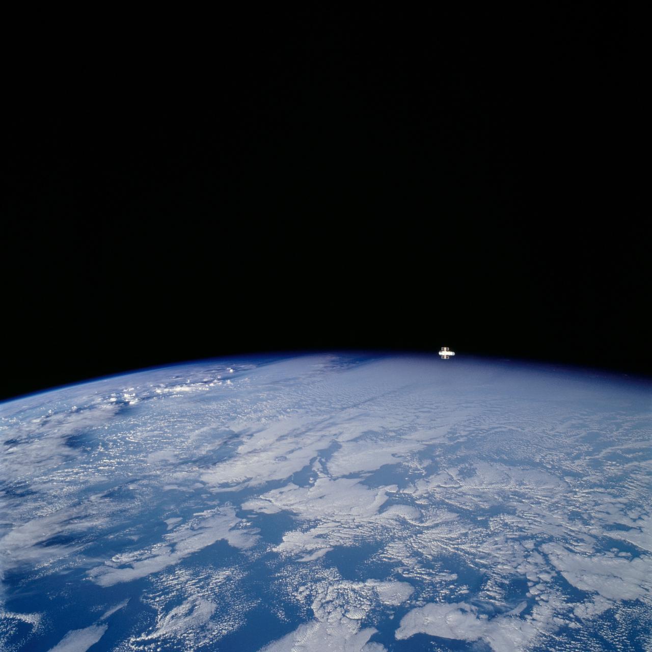
STS109-729-072 (9 March 2002) --- Looking westward, one of the STS-109 crew members photographed the newly serviced and upgraded Hubble Space Telescope (HST) near the earth's limb to the upper right of the center of this 70mm image. The Space Shuttle Columbia was located over the Atlantic Ocean southwest of the Cape Verde Islands when this image was acquired. Low to mid-altitude clouds are visible across the image. Some thunderstorms can be seen near the left center of the image as the sun reflects off the higher cloud tops.
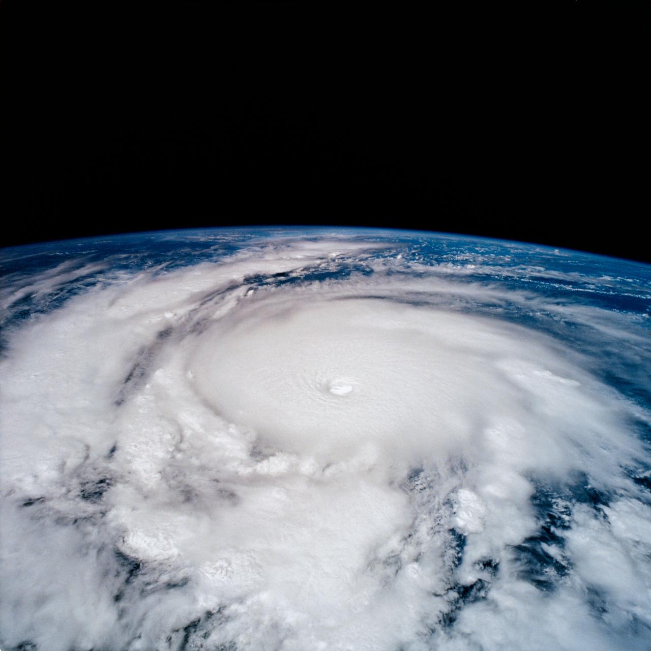
STS-65 Earth observation taken aboard Columbia, Orbiter Vehicle (OV) 102, shows Hurricane Emilia in the Eastern Pacific Ocean. Hurricane Emilia's wind speeds exceeded 150 knots. This high oblique view of the storm shows numerous spiral bands of thunderstorms, overshooting thunderstorm tops at the tropopause, and a well developed eye at the center of the picture. Shuttle photography provides high resolution details of these powerful and destructive systems that are not fully possible from lower-resolution, unmanned satellites.
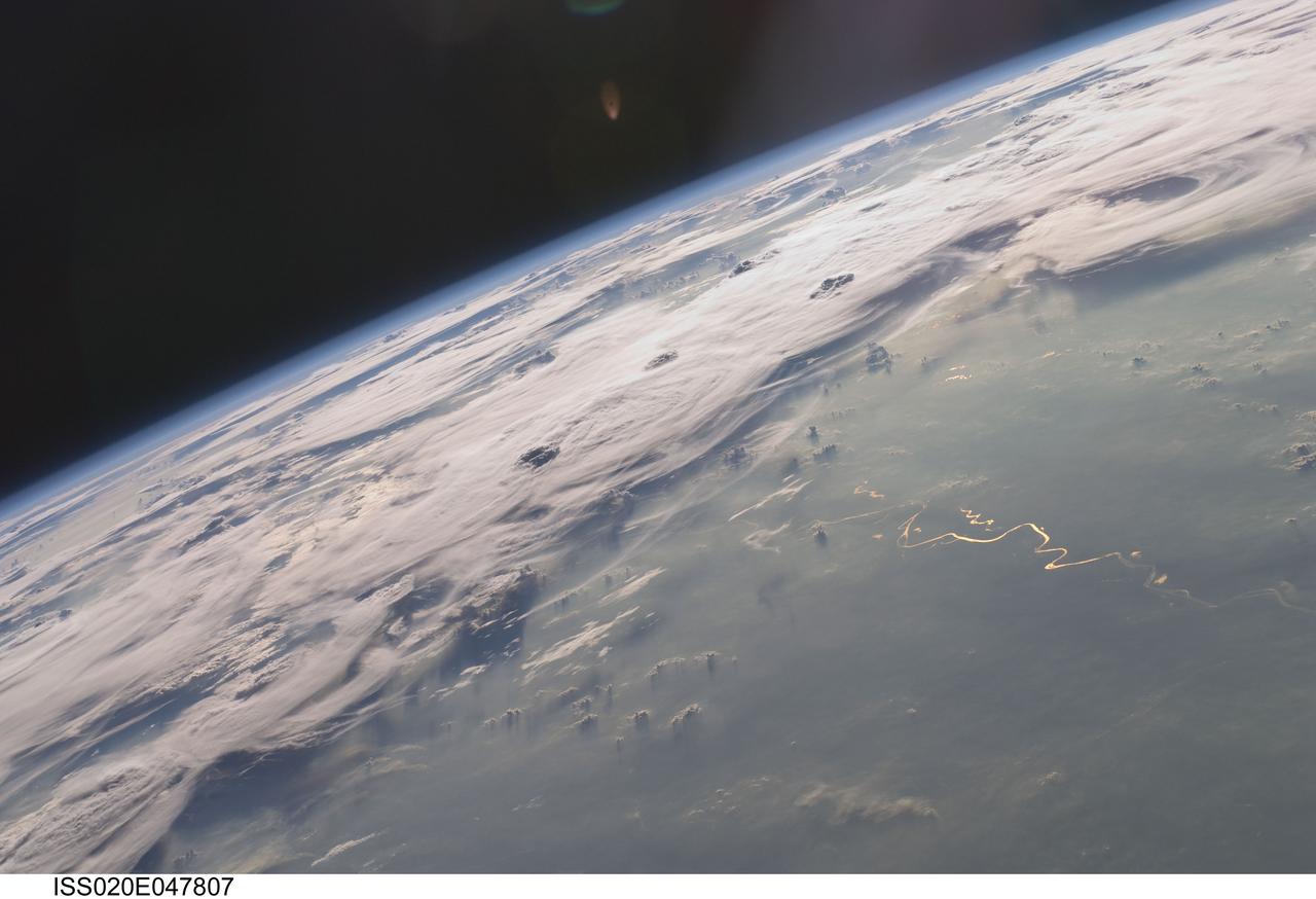
ISS020-E-047807 (6 Oct. 2009) --- Thunderstorms on the Brazilian horizon are featured in this image photographed by an Expedition 20 crew member on the International Space Station. A picturesque line of thunderstorms and numerous circular cloud patterns filled the view as the station crew members looked out at the limb and atmosphere (blue line on the horizon) of Earth. This region displayed in the photograph (top) includes an unstable, active atmosphere forming a large area of cumulonimbus clouds in various stages of development. The crew was looking west southwestward from the Amazon Basin, along the Rio Madeira, toward Bolivia when the image was taken. The distinctive circular patterns of the clouds in this view are likely caused by the aging of thunderstorms. Such ring structures often form during the final stages of a storm?s development as their centers collapse. Sunglint is visible on the waters of the Rio Madeira and Lago Acara in the Amazon Basin. Widespread haze over the basin gives the reflected light an orange hue. The Rio Madeira flows northward and joins the Amazon River on its path to the Atlantic Ocean. Scientists believe that a large smoke plume near the bottom center of the image may explain one source of the haze.
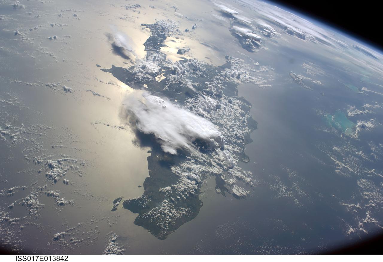
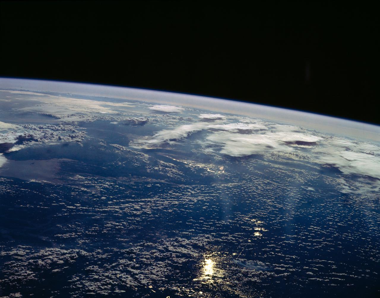
ISS017-E-013842 (19 Aug. 2008) --- A serene view of a portion of the Greater Antilles islands in the Caribbean Sea. The island of Hispaniola is in the foreground, comprised of the Dominican Republic and Haiti (in the sunglint). Looking toward the horizon, the eastern tip of Cuba is seen through the clouds and thunderstorms that are scattered over the islands. The light blue shallower areas, to the right or north of Hispaniola and extending toward the Earths limb, are the Turks and Caicos islands and the Acklins Islands. The Great Inagua island is off the coast of Haiti. These islands are located along the geological border of the North American Plate (to the right) and the Caribbean Plate (to the left). The photo was taken by the Expedition 17 crew onboard the International Space Station on Aug 19, 2008 with a 28 mm lens.