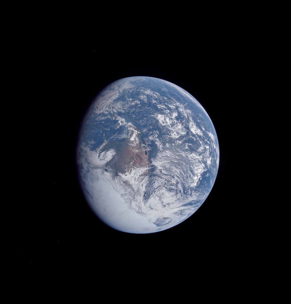
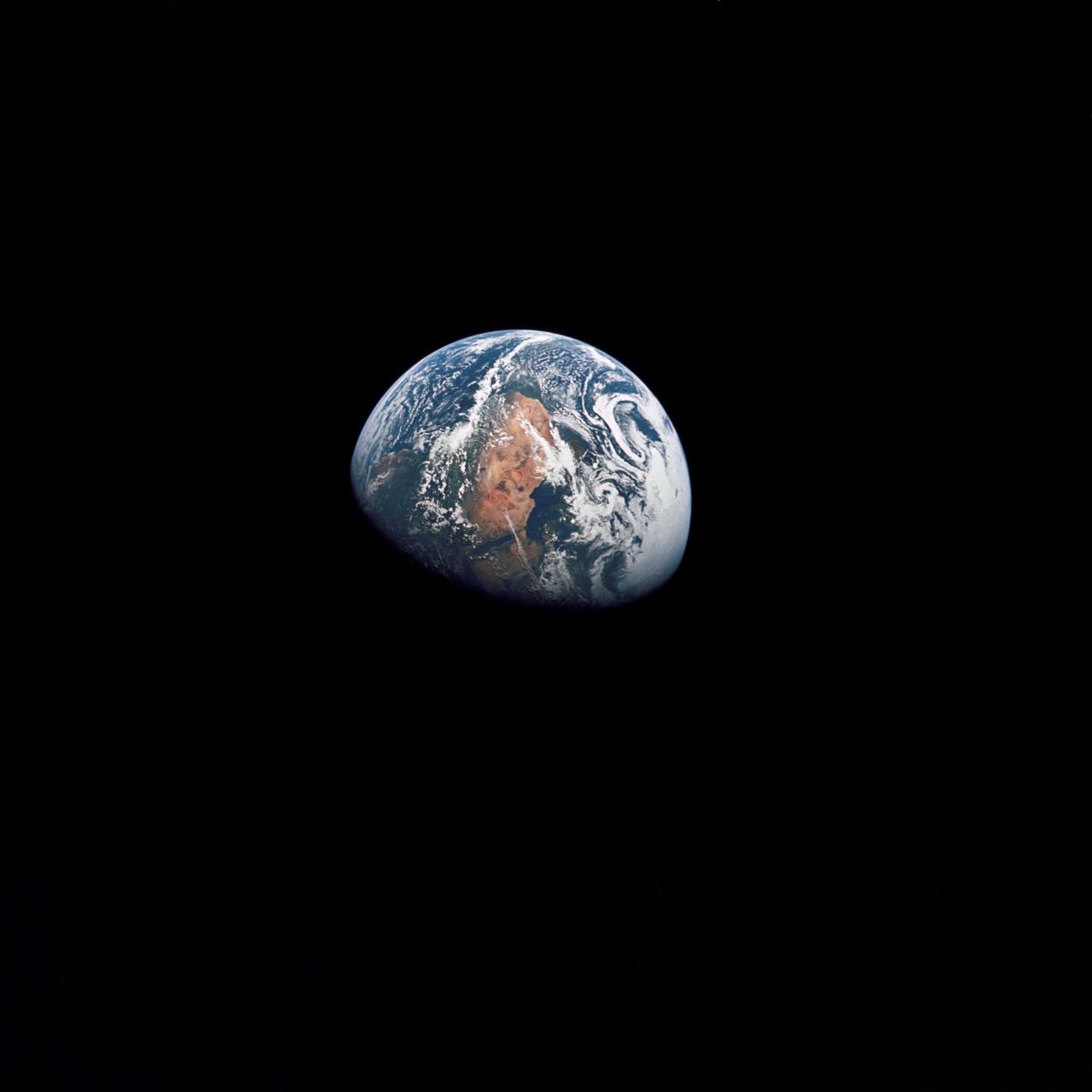
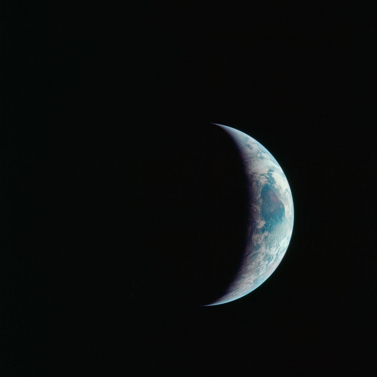
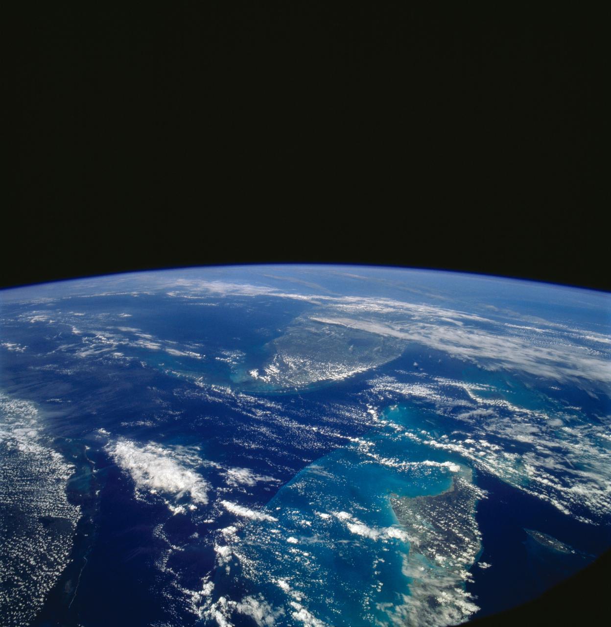
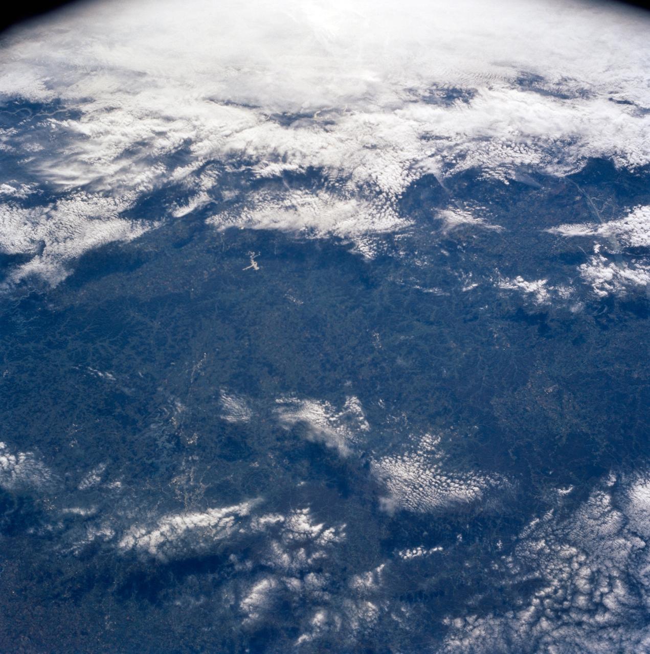
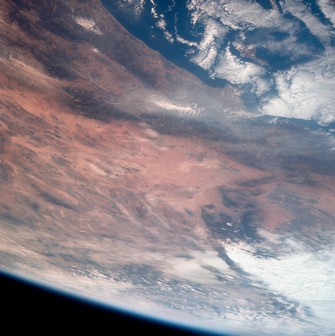
AS16-118-18885 (16 April 1972) --- A good view of Earth photographed about one and one-half hours after trans-lunar injection on April 16, 1972. Although there is much cloud cover, the United States in large part, most of Mexico and some parts of Central America are clearly visible. Note Lake Michigan and Lake Superior and the Bahama Banks (see different shade of blue below Florida). Just beginning man's fifth lunar landing mission were astronauts John W. Young, commander; Thomas K. Mattingly, II, command module pilot and Charles M. Duke Jr., lunar module pilot. While astronauts Young and Duke descended in the Lunar Module (LM) "Orion" to explore the Descartes highlands region of the moon, astronaut Mattingly remained with the Command and Service Modules (CSM) "Casper" in lunar orbit.
AS16-118-18880 (16 April 1972) --- A good view of Earth photographed about one hour after trans-lunar injection on April 16, 1972. Although there is much cloud cover, the United States in large part, most of Mexico and some of Central America are clearly visible. Note the Great Lakes (Michigan and Superior) and the Bahama Banks (note different shade of blue below Florida). While astronauts John W. Young, commander, and Charles M. Duke Jr., lunar module pilot, descended in the Lunar Module (LM) "Orion" to explore the Descartes highlands region of the moon, astronaut Thomas K. (Ken) Mattingly II, command module pilot, remained with the Command and Service Modules (CSM) "Casper" in lunar orbit.

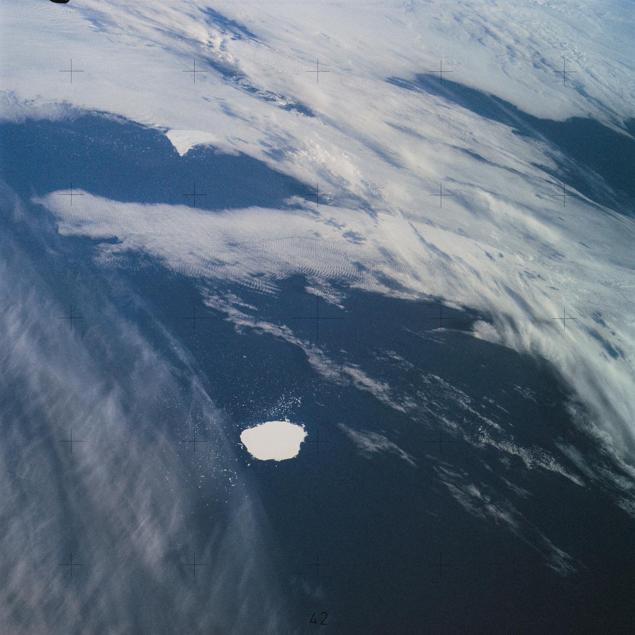
AS17-148-22727 (7 Dec. 1972) --- This view of Earth was seen by the Apollo 17 crew as they traveled toward the moon on their NASA lunar landing mission. This outstanding trans-lunar coast photograph extends from the Mediterranean Sea area to the Antarctica south polar ice cap. This is the first time the Apollo trajectory made it possible to photograph the south polar ice cap. Note the heavy cloud cover in the Southern Hemisphere. Almost the entire coastline of Africa is clearly visible. The Arabian Peninsula can be seen at the northeastern edge of Africa. The large island off the coast of Africa is the Malagasy Republic. The Asian mainland is on the horizon toward the northeast. The Apollo 17 crew consisted of astronauts Eugene A. Cernan, mission commander; Ronald E. Evans, command module pilot; and Harrison H. Schmitt, lunar module pilot. While astronauts Cernan and Schmitt descended in the Lunar Module (LM) to explore the moon, astronaut Evans remained with the Command and Service Modules (CSM) in lunar orbit.

STS006-46-617 (4-9 April 1983) --- This view of sunset over the Amazon Basin was photographed with a 35mm camera from the Earth-orbiting space shuttle Challenger. The reusable vehicle was making its first trip into space and carried a crew of astronauts Paul J. Weitz, Karol J. Bobko, F. Story Musgrave and Donald H. Peterson. Photo credit: NASA
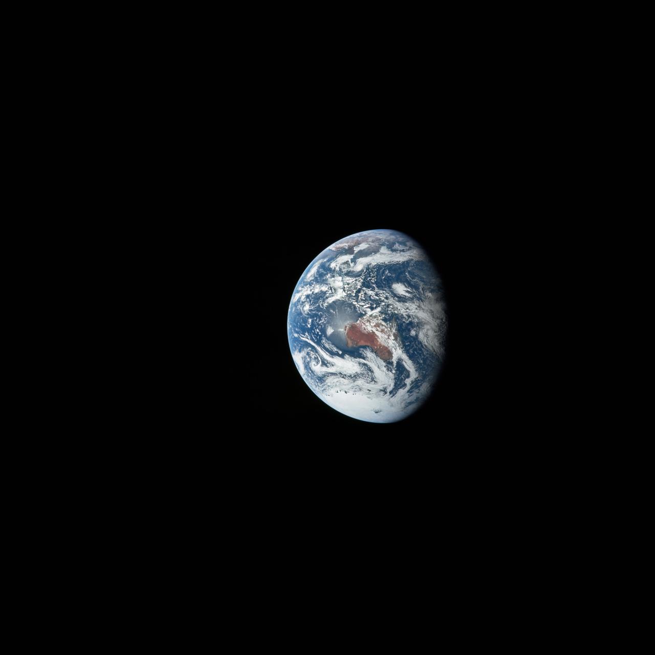
AS12-50-7362 (14 Nov. 1969) --- A view of one-third of Earth, with Australia on the horizon, as photographed by the three-man crew of Apollo 12. The Command and Service Modules, mated to the Lunar Module (yet to be removed and transpositioned for landing) were en route to the moon for man's second mission there. Onboard the spacecraft were astronauts Charles Conrad Jr., Richard F. Gordon Jr. and Alan L. Bean. Photo credit: NASA
AS17-148-22742 (7-19 Dec. 1972) --- Most of Australia (center) and part of Antarctica are visible in this photo of a three-quarters Earth, recorded with a 70mm handheld Hasselblad camera using a 250mm lens. The three astronauts aboard the Command and Service Modules (CSM) were in the trans-lunar coast phase of the journey when one of them snapped this shot. While astronauts Eugene A. Cernan commander, and Harrison H. Schmitt, lunar module pilot, descended in the Lunar Module (LM) "Challenger" to explore the Taurus-Littrow region of the moon, astronaut Ronald E. Evans, command module pilot, remained with the CSM "America" in lunar orbit.
AS10-34-5026 (18-26 May 1969) --- An Apollo 10 photograph of Earth taken from 100,000 miles away. Visible are many areas of Europe and Africa. Among the features and countries identifiable are Portugal, Spain, Italy, the Mediterranean Sea, Greece, Turkey, Bulgaria, the Black Sea, Libya, Egypt, Saudi Arabia, the Sinai Peninsula, the Nile Delta, Lake Chad, and South Africa. The crew members for Apollo 10 are astronauts Thomas P. Stafford, commander; John W. Young, command module pilot; and Eugene E. Cernan, lunar module pilot. Astronaut Young remained in lunar orbit, in the Command and Service Modules (CSM) "Charlie Brown", while astronauts Stafford and Cernan descended to within nine miles of the lunar surface, in the Lunar Module (LM) "Snoopy".
AS11-36-5337 (16 July 1969) --- This view of Earth showing clouds over its surface was photographed from the Apollo 11 spacecraft during its translunar journey toward the moon. The spacecraft was already about 10,000 nautical miles from Earth when this picture was taken. Portions of the land mass of North America and Central America can be seen. Aboard Apollo 11 were astronauts Neil A. Armstrong, Michael Collins and Edwin E. Aldrin Jr.
AS13-60-8588 (17 April 1970) --- This photograph of Earth was taken from the National Aeronautics and Space Administration's (NASA) Apollo 13 spacecraft during its trans-Earth journey home. The most visible land mass includes southwestern United States and northwestern Mexico. The peninsula of Baja California is clearly seen. Most of the land area is under heavy cloud cover. The Apollo 13 crew consisted of astronauts James A. Lovell Jr., commander; John L. Swigert Jr., command module pilot; and Fred W. Haise Jr., lunar module pilot.
AS10-34-5013 (18 May 1969) --- A view of Earth from 36,000 nautical miles away as photographed from the Apollo 10 spacecraft during its trans-lunar journey toward the moon. While the Yucatan Peninsula is obscured by clouds, nearly all of Mexico north of the Isthmus of Tehuantepec can be clearly delineated. The Gulf of California and Baja California and the San Joaquin Valley can be easily identified. Also, the delta of the Rio Grande River and the Texas coast are visible. Note the color differences (greens - east, browns - west) along the 100 degrees meridian. The crew members on Apollo 10 are astronauts Thomas P. Stafford, commander; John W. Young, command module pilot; and Eugene E. Cernan, lunar module pilot. Astronaut Young remained in lunar orbit, in the Command and Service Modules (CSM) "Charlie Brown", while astronauts Stafford and Cernan descended to within nine miles of the lunar surface, in the Lunar Module (LM) "Snoopy".

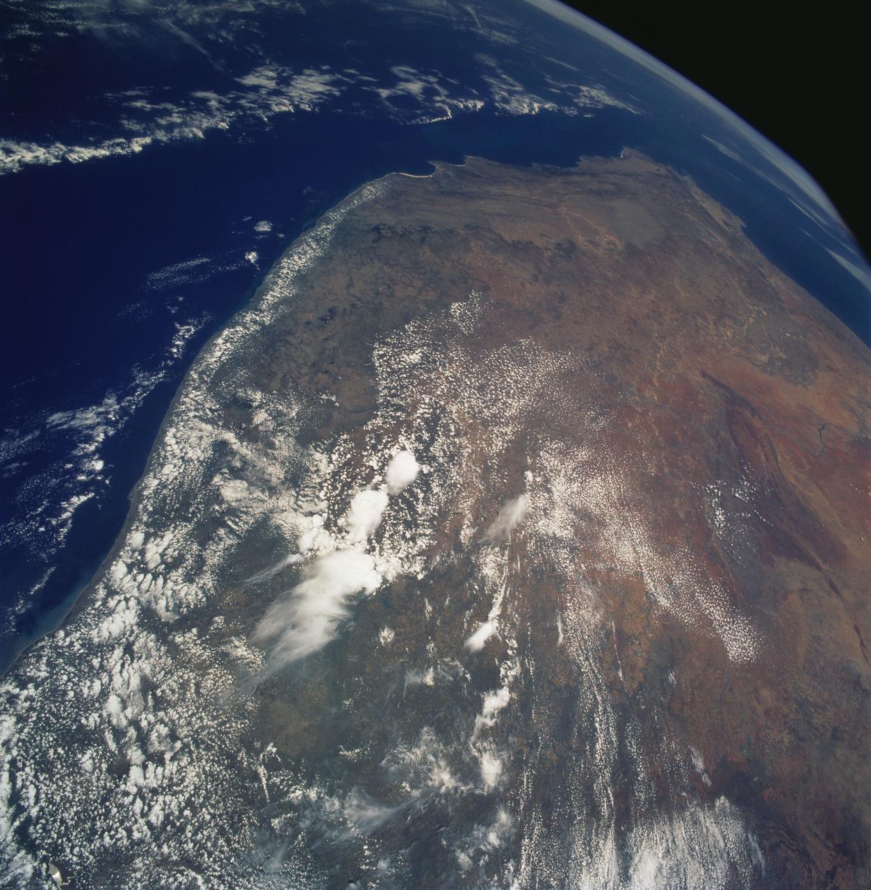
STS058-77-083 (18 Oct-1 Nov 1993) --- In this scene of the south coast of Africa, Cape Agulhas, the southernmost point on the continent, appears as the leftmost cape. Viewed with the Earth's limb top left, clouds at bottom, the view direction is west and north top right. The Cape of Good Hope, with Cape Town nearby, is the thin spike beyond. The great bay in the foreground is Algoa Bay with the city of Port Elizabeth. This was the first time European voyagers are known to have rounded the Cape of Good Hope in their quest to reach India by sea. The entire fold mountain belt of southern Africa is visible: these mountains appear as green (forested) wavy structures stretching west form the foreground, to the Cape of Good Hope, and then northwards some distance. One theory about their origin is that the Falkland Plateau, now an undersea extension of South America, was jostled up against Africa more than 150 million years ago, in times before the Atlantic Ocean existed, before Africa and South America drifted apart from one another. The jostling caused the evolution of the fold mountain belt.
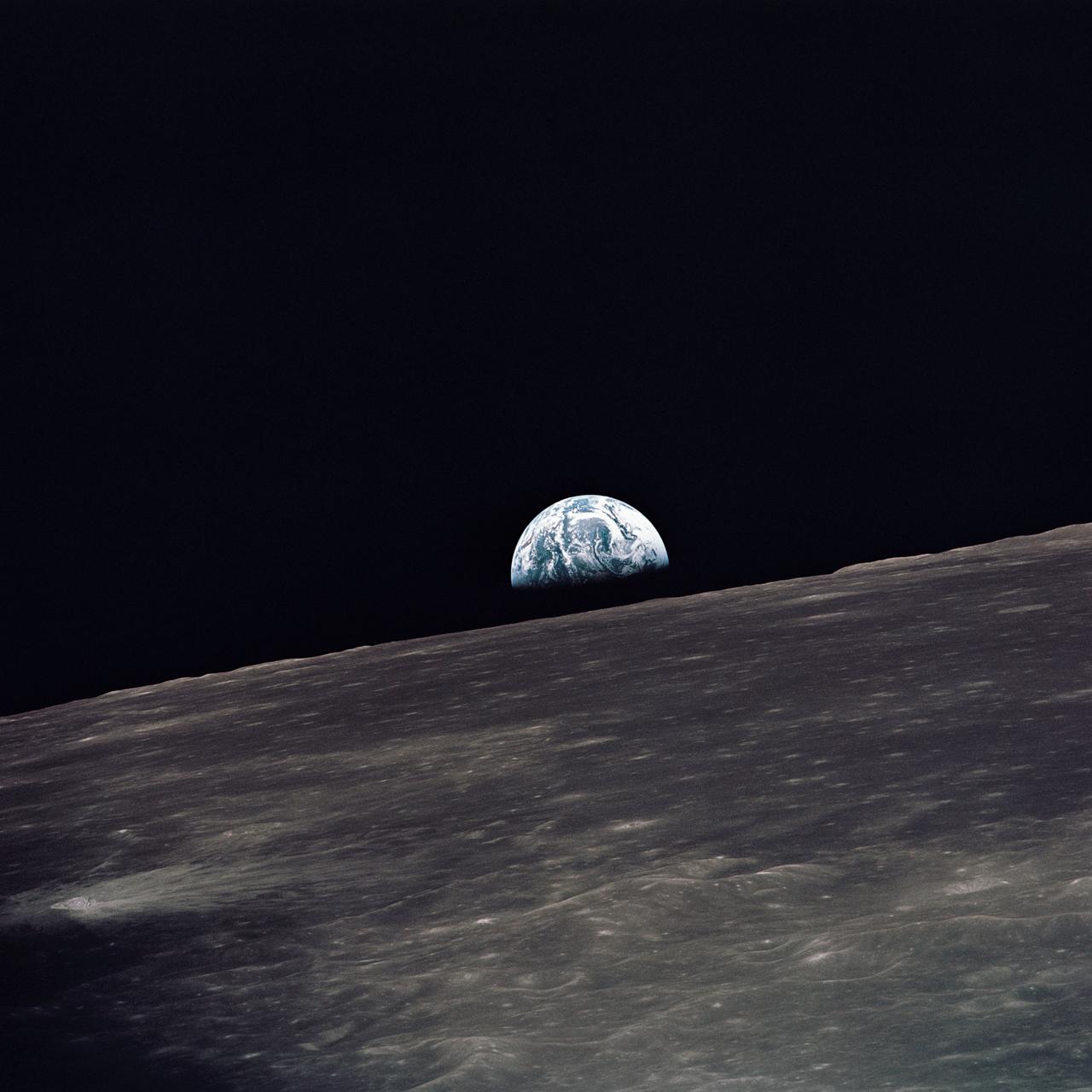
AS10-27-3890 (18-26 May 1969) --- A view of Earth rising above the lunar horizon photographed from the Apollo 10 Lunar Module, looking west in the direction of travel. The Lunar Module at the time the picture was taken was located above the lunar farside highlands at approximately 105 degrees east longitude.

AS11-36-5299 (16 July 1969) --- This view of Earth showing clouds over water was photographed from the Apollo 11 spacecraft following translunar injection. While astronauts Neil A. Armstrong, commander, and Edwin E. Aldrin Jr., lunar module pilot, descended in the Lunar Module (LM) "Eagle" to explore the Sea of Tranquility region of the moon, astronaut Michael Collins, command module pilot, remained with the Command and Service Modules (CSM) "Columbia" in lunar orbit.
AS11-36-5355 (17 July 1969) --- Most of Africa and portions of Europe and Asia can be seen in this spectacular photograph taken from the Apollo 11 spacecraft during its trans-lunar coast toward the moon. Apollo 11, with astronauts Neil A. Armstrong, commander; Michael Collins, command module pilot; and Edwin E. Aldrin Jr., lunar module pilot, onboard was already 98,000 nautical miles from Earth when this picture was made. While astronauts Armstrong and Aldrin descended in the Lunar Module (LM) "Eagle" to explore the Sea of Tranquility region of the moon, astronaut Collins remained with the Command and Service Modules (CSM) "Columbia" in lunar orbit.
SL3-114-1625 (July-September 1973) --- An excellent view of the expended S-IVB second stage of the Skylab 3/Saturn 1B space vehicle is seen in this photograph taken from the Skylab 3 Command and Service Module (CSM) in Earth orbit. The land mass below is Italy and France, with part of the Mediterranean Sea visible. This photograph was taken with a handheld 70mm Hasselblad camera using a 100mm lens, and medium speed Ektachrome film. Photo credit: NASA
AS08-16-2596 (21-27 Dec. 1968) --- View of Earth as photographed by the Apollo 8 astronauts during their lunar orbit mission. North is about five percent to the right of vertical. The sunset terminator crosses North and South America. Clouds cover most of the United States. Only the desert southwest and Florida are clear.
AS11-44-6689 (16-24 July 1969) --- One-third of the Earth's sphere illuminated, Earth's terminator, sunglint, a portion of east Africa, as photographed from the Apollo 11 spacecraft during its first lunar landing mission. While astronauts Neil A. Armstrong, commander, and Edwin E. Aldrin Jr., lunar module pilot, descended in the Lunar Module (LM) "Eagle" to explore the Sea of Tranquility region of the moon, astronaut Michael Collins, command module pilot, remained with the Command and Service Modules (CSM) "Columbia" in lunar orbit.
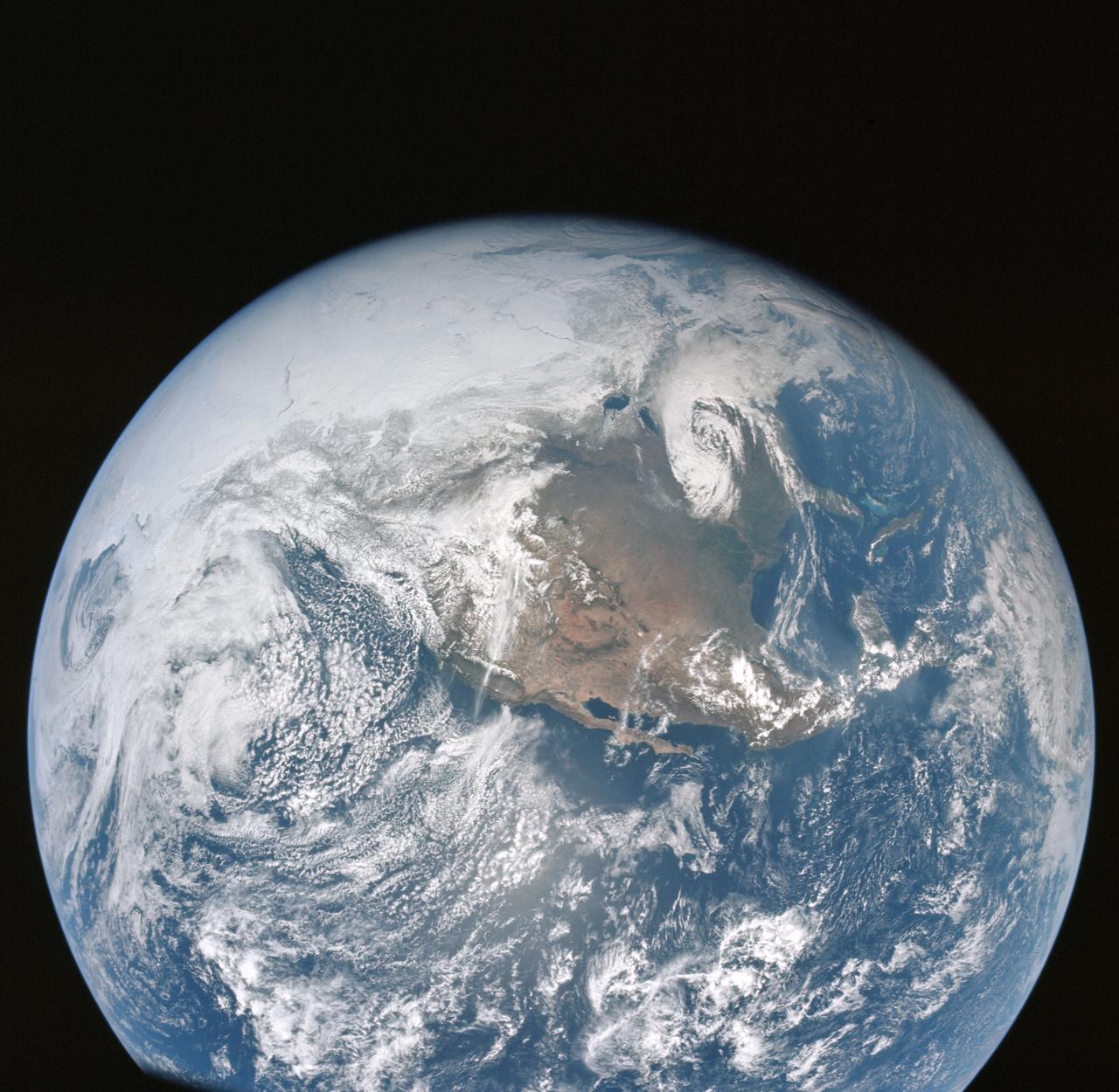
AS16-118-18873 (16 April 1972) --- A good view of Earth photographed shortly after trans-lunar injection of April 16, 1972. Although there is much cloud cover (over Canada and the oceans), the United States in large part, most of Mexico and some parts of Central America are clearly visible. Note Lake Michigan and Lake Superior, also note the Bahama Banks at upper right part of the sphere. A large part of the Rocky Mountain Range is also visible. Just beginning man's fifth lunar landing mission were astronauts John W. Young, commander; Thomas K. Mattingly II, command module pilot; and Charles M. Duke Jr., lunar module pilot. While astronauts Young and Duke descended in the Lunar Module (LM) to explore the moon, astronaut Mattingly remained with the Command and Service Modules (CSM) in lunar orbit.

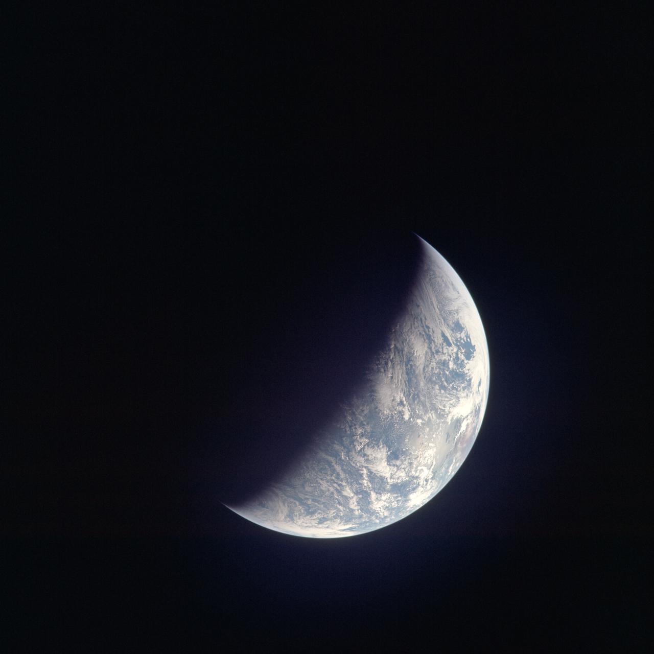
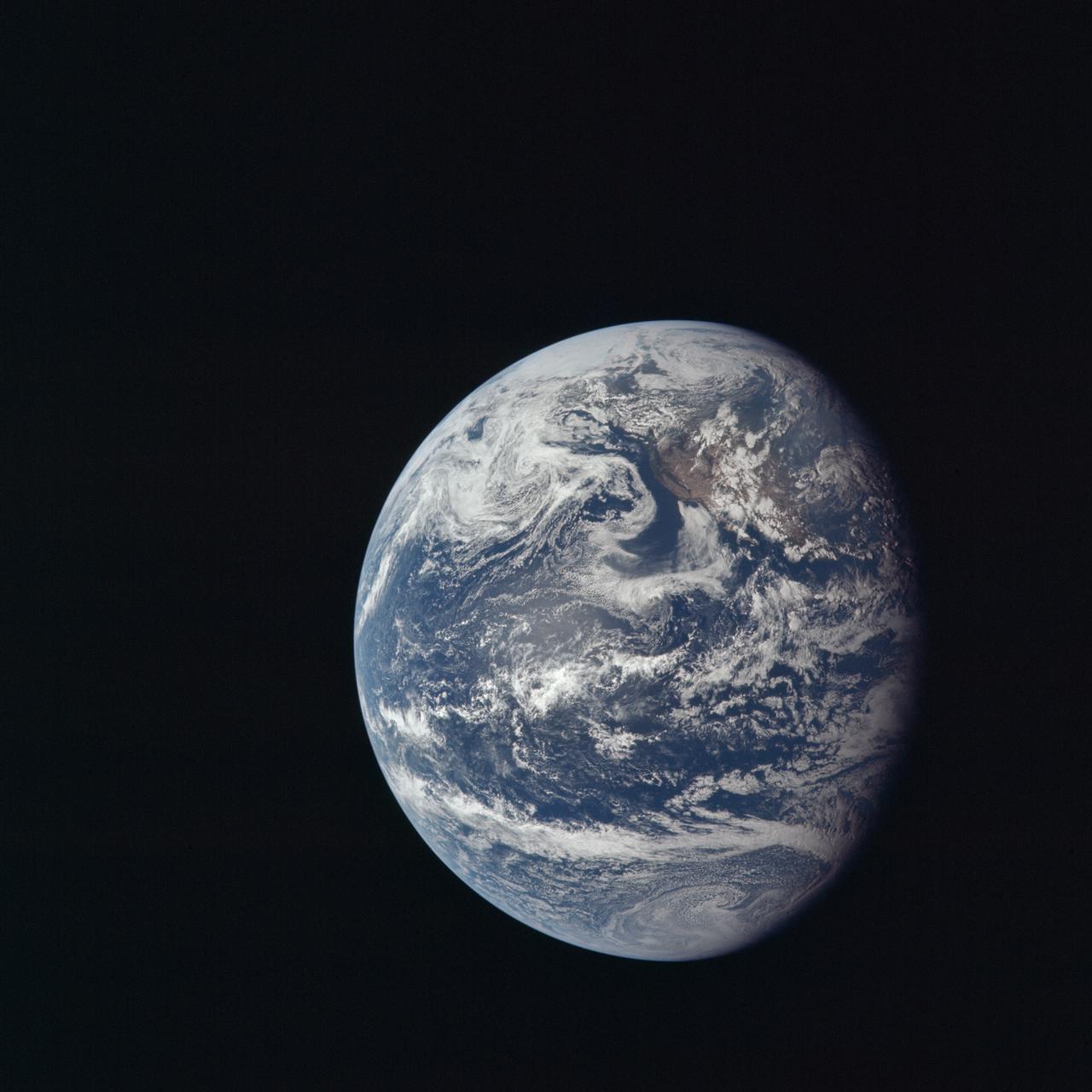
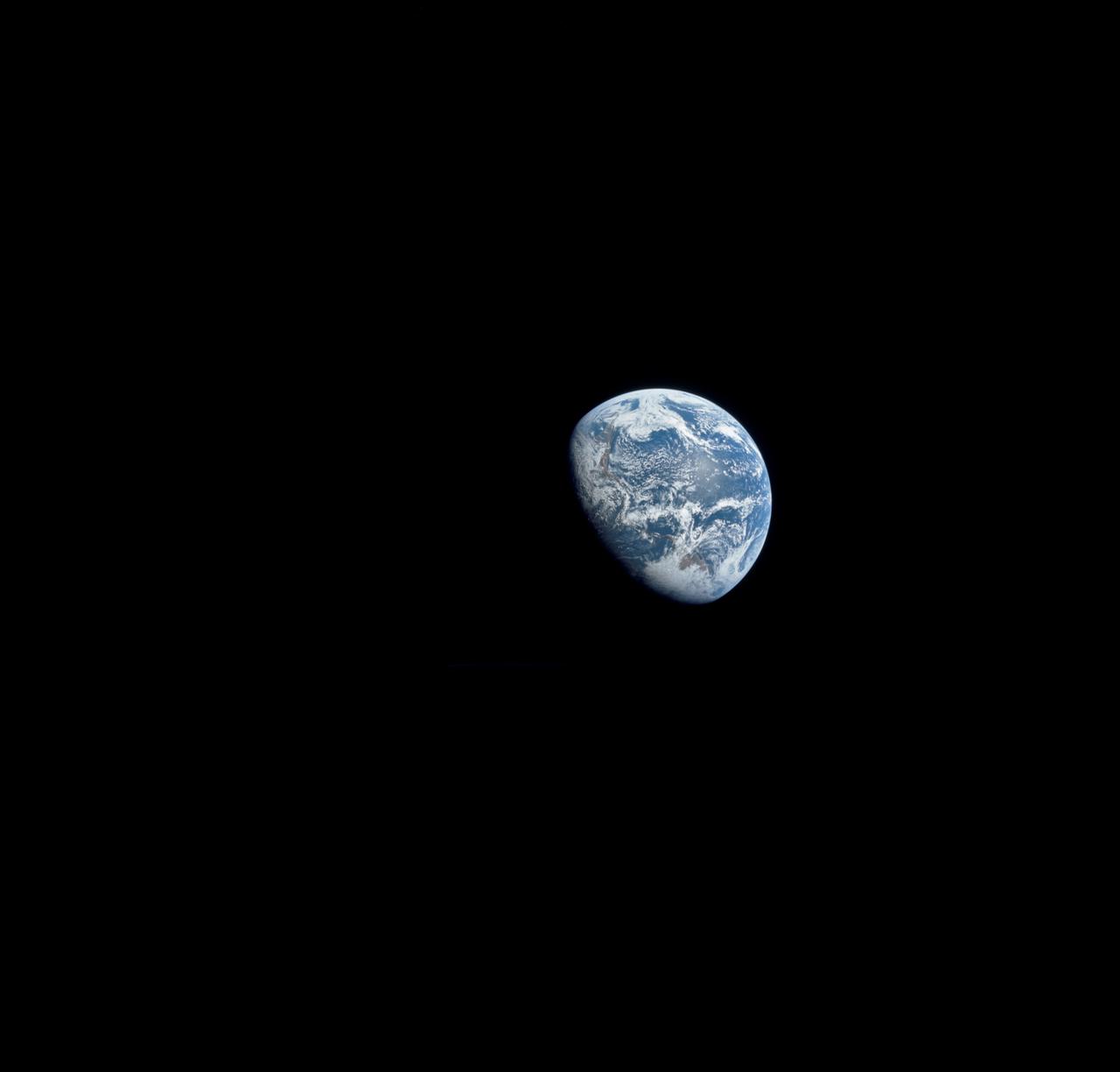
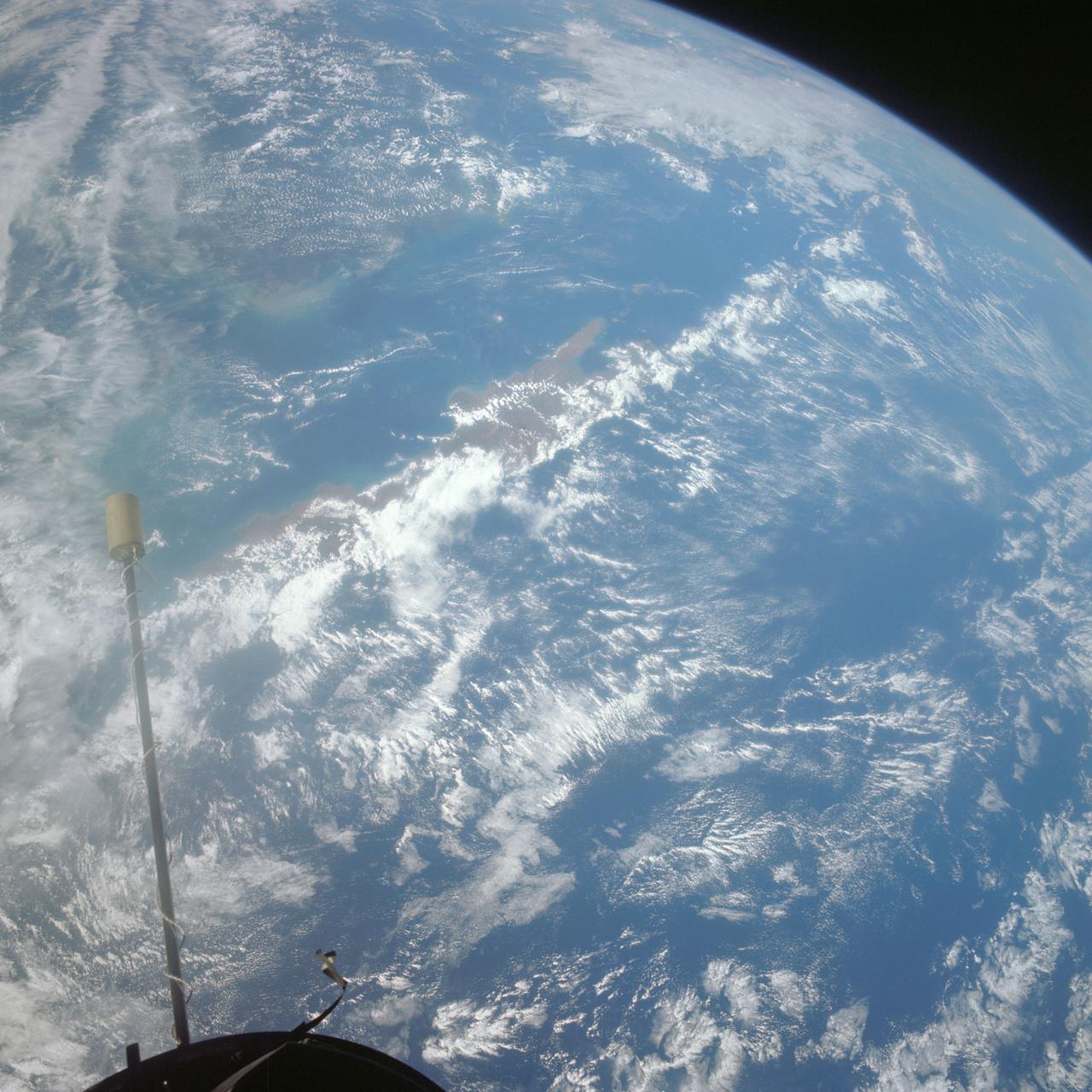
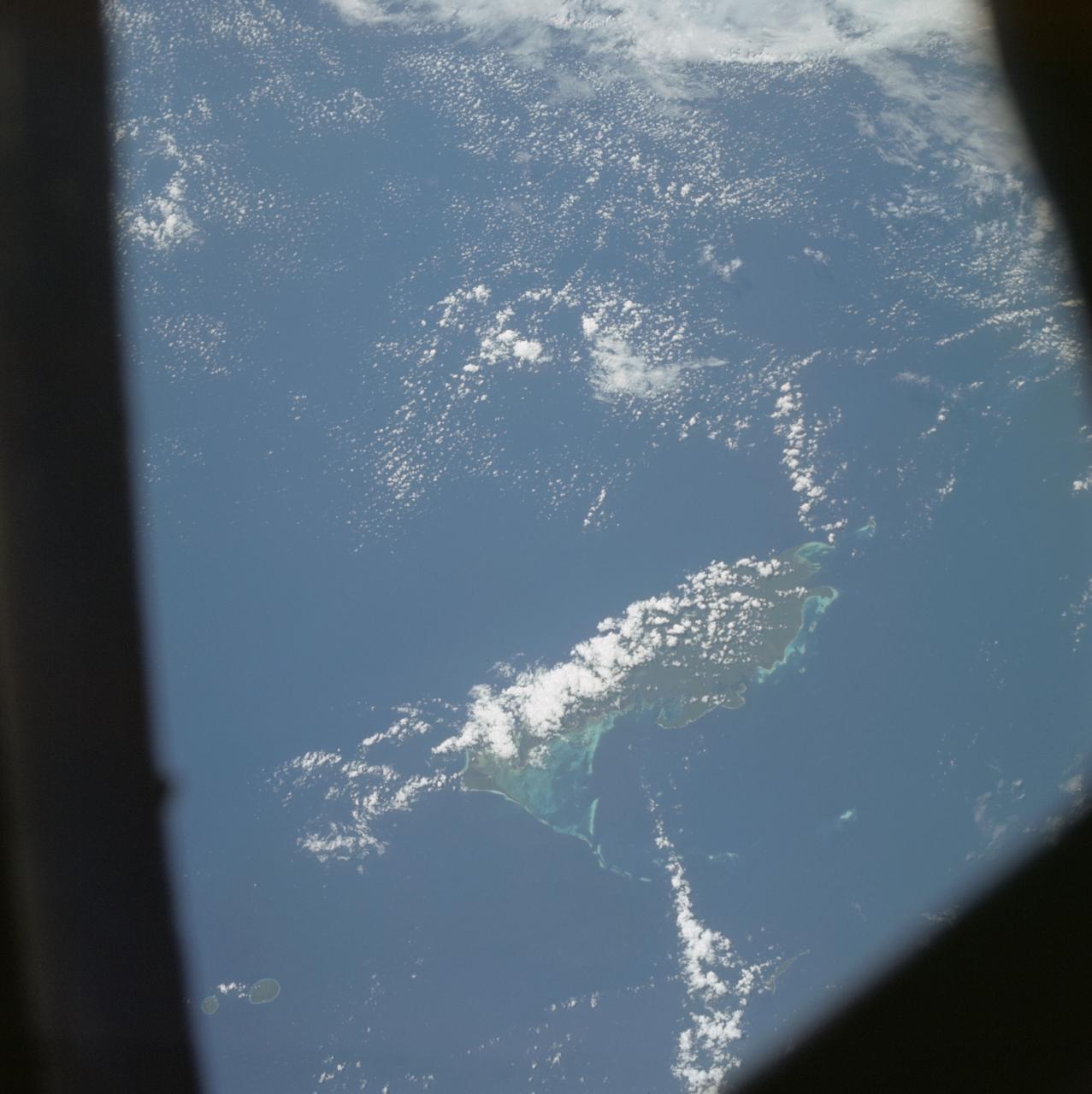
AS15-91-12343 (26 July 1971) --- This view of Earth was photographed by the Apollo 15 crewmen as they sped toward the fourth lunar landing. The spacecraft was between 25,000 and 30,000 nautical miles from Earth when this photo was made. The United States (note Florida), Central America and part of Canada can be seen at the left side of the picture, with South America at lower center. Spain and the northwest part of Africa can be seen at right. The Bahamas Banks, unique geological feature, can be seen (different shade of blue) east of Florida. Also note large North Atlantic storm front moving over Greenland in upper center.

AS10-34-5010 (18 May 1969) --- This photograph of Earth was taken from the Apollo 10 spacecraft shortly after trans-lunar insertion. The counter-clockwise arrangement of the cloud formations indicates a northern hemisphere view, although insufficient amounts of land are visible for exact location.

STS009-11-675 (December 1983) --- The Space Shuttle Columbia passes into a brilliant sunrise scene during the STS-9\Spacelab 1 mission. The photograph was taken with a 35mm camera aimed through Columbia's aft flight deck windows. Part of the science module, which hosted more than a week's scientific experimentation, is silhouetted against the scene.

41G-121-099 (5-13 Oct. 1984) --- Hurricane Josephine was photographed with a medium format camera aimed through the space shuttle Challenger's aft flight deck windows during NASA's 41-G mission. The hurricane's eye can be seen below the orbiter's vertical stabilizer. The large storm off the Florida coast did not prevent the spacecraft with its record of seven crew members aboard from landing safely at the KSC landing facility. Photo credit: NASA

41G-102-047 (13 Oct. 1984) --- An unusual picture, photographed by astronaut Kathryn D. Sullivan, shows the beginning and ending location of her eight-day mission in space with six other 41-G crew members aboard the space shuttle Challenger. The picture was made moments before touchdown at the KSC landing facility. Dr. Sullivan aimed a 35mm camera through the port hole in Challenger's hatch. The five ground features represented as circles or pentagonals are launch areas. Photo credit: NASA
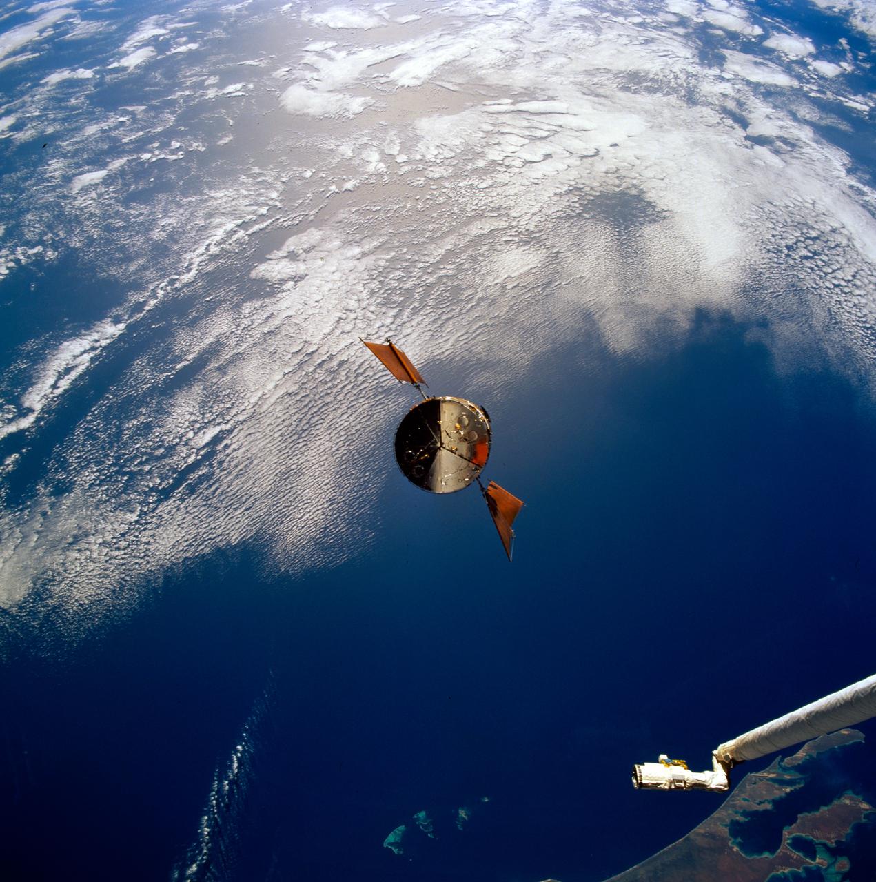
STS061-93-031 (4 Dec 1993) --- Part of the vast Indian Ocean forms the backdrop for this scene of the Hubble Space Telescope (HST) as it approaches the Space Shuttle Endeavour. Denham Sound and Shark Bay, on Australia's west coast, are just below the waiting mechanical arm at lower right corner.
S66-54558 (14 Sept. 1966) --- Del Rio and Eagle Pass area of the Rio Grande Valley of Texas and Mexico as seen from the Gemini-11 spacecraft during its 29th revolution of Earth. Photo credit: NASA
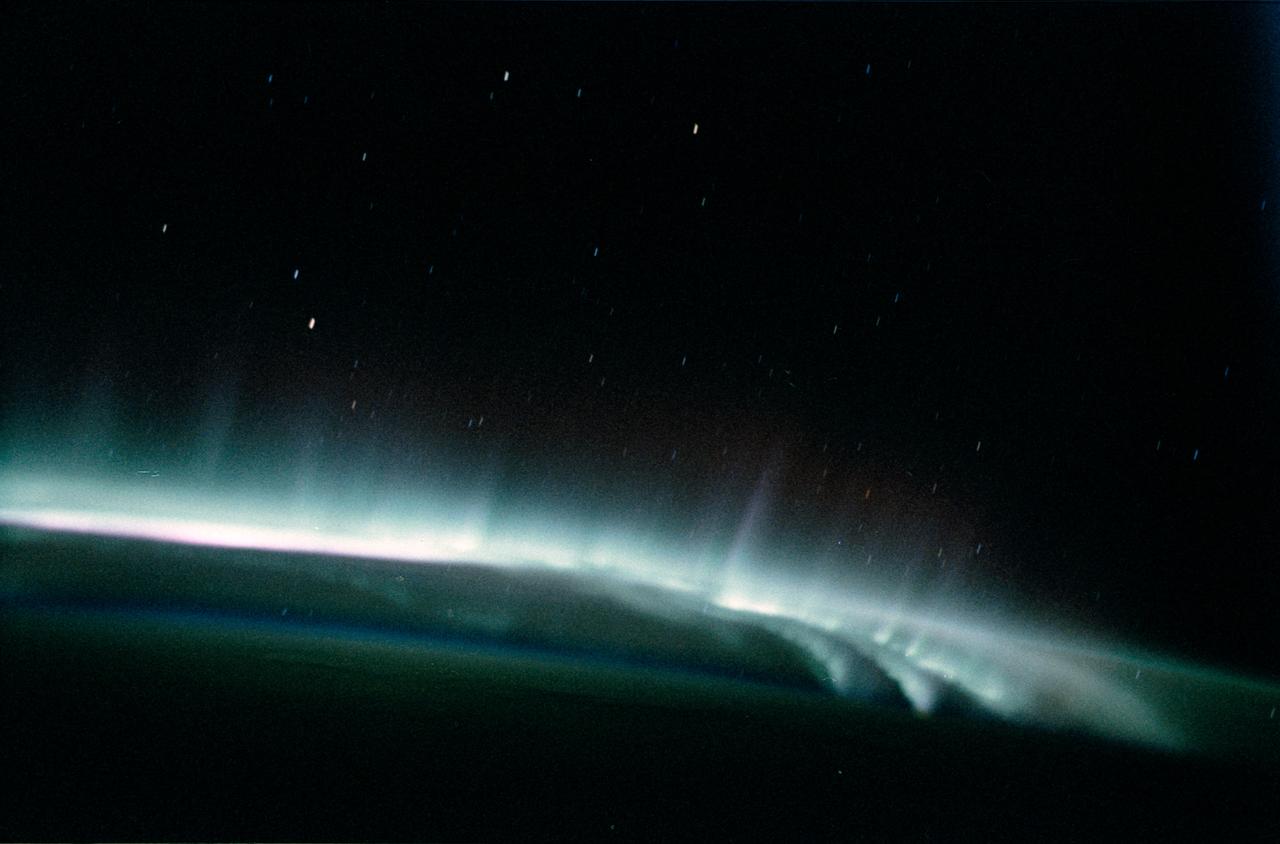
SL3-130-3130 (July-September 1973) --- An excellent view of the southern aurora, luminous bands or streamer of light, in the Southern Hemisphere, as photographed from the Skylab space station in Earth orbit. The space station was moving into the sunlight when this picture was taken. This view is near the edge of the aurora cap. The surface of the Earth is in the foreground. The permanent aurora over the South Pole is in the background. Scientist-astronaut Owen K. Garriott, Skylab 3 science pilot, took this photograph with a hand-held 35mm Nikon camera, with a four-second exposure at f/1.2, using high-speed Ektacrome film. Because auroras are caused by solar activity, they occur at the same time in the Northern and Southern hemispheres. Photo credit: NASA
STS059-213-019 (9-20 April 1994) --- SRL scientists will use these photographs with the radar imagery to discriminate among different ages of basalt flows, and different ecosystems of shrub communities, on these equatorial volcanic islands. Aims are twofold: to understand the history of physical and biological systems on the islands themselves, and to extend what is learned to other, less-well-known areas globally. Hasselblad photograph.

View of antenna and solar arrays (with an Earth limb in the background) taken from a window in the Russian Soyuz spacecraft currently docked to the International Space Station. Photo taken by an Expedition 36 crewmember. Per Twitter message: View out the window to the right of my seat in Soyuz while docked to ISS.
STS059-L09-162 (9-20 April 1994) --- Orient with the snow-covered mountains (Sierra Nevada of California) in the upper right corner. Then Owens Valley runs along the top of the photograph to Owens Lake playa at top center. The upper end of Death Valley extends from right to left in the foreground, with the drainage running down to a playa at Stovepipe Wells in the left foreground. Geologists are studying microwave signatures of the different playa surfaces, and the coatings on alluvial fans that extend from mountain masses, to try to sort out the history of different climates in this formerly wet but now hyperarid region.
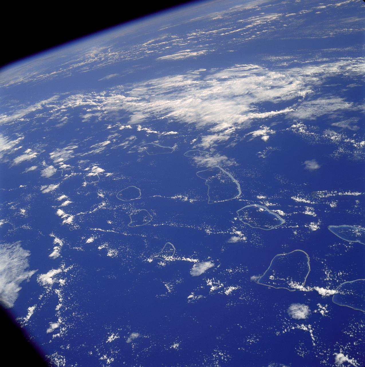
AS07-04-1590 (20 Oct. 1968) --- Tuamotu Archipelago in the South Pacific Ocean, looking southwest, as photographed from the Apollo 7 spacecraft during its 141st revolution of Earth. The photograph was taken from an altitude of 110 nautical miles, at a ground elapsed time of 224 hours and 18 minutes.
AST-17-1378 (20 July 1975) --- A near vertical view of the most southerly portion of the Island of Sicily in the Mediterranean Sea, as photographed from the Apollo spacecraft in Earth orbit during the joint U.S.-USSR Apollo-Soyuz Test Project mission. This view includes the towns of Gala, Pachino, Avela and Pozzalo. The photograph was taken at an altitude of 228 kilometers (141 statute miles) with a 70mm Hasselblad camera using high-definition aerial Ektachrome SO-242 type film.
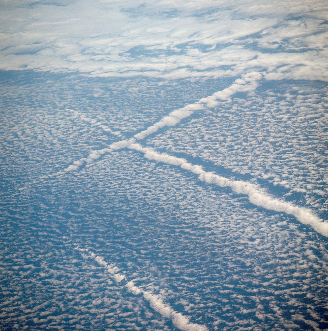
AST-01-042 (16 July 1975) --- An oblique view of unique cloud patterns over the Pacific Ocean caused by aircraft contrail shadows altering cumulus clouds and forming straight line clouds, as photographed from the Apollo spacecraft in Earth orbit during the joint U.S.-USSR Apollo-Soyuz Test Project mission. This area is southwest of Los Angeles, California. This photograph was taken at an altitude of 177 kilometers (110 statute miles) with a 70mm Hasselblad camera using medium-speed Ektachrome QX-807 type film.
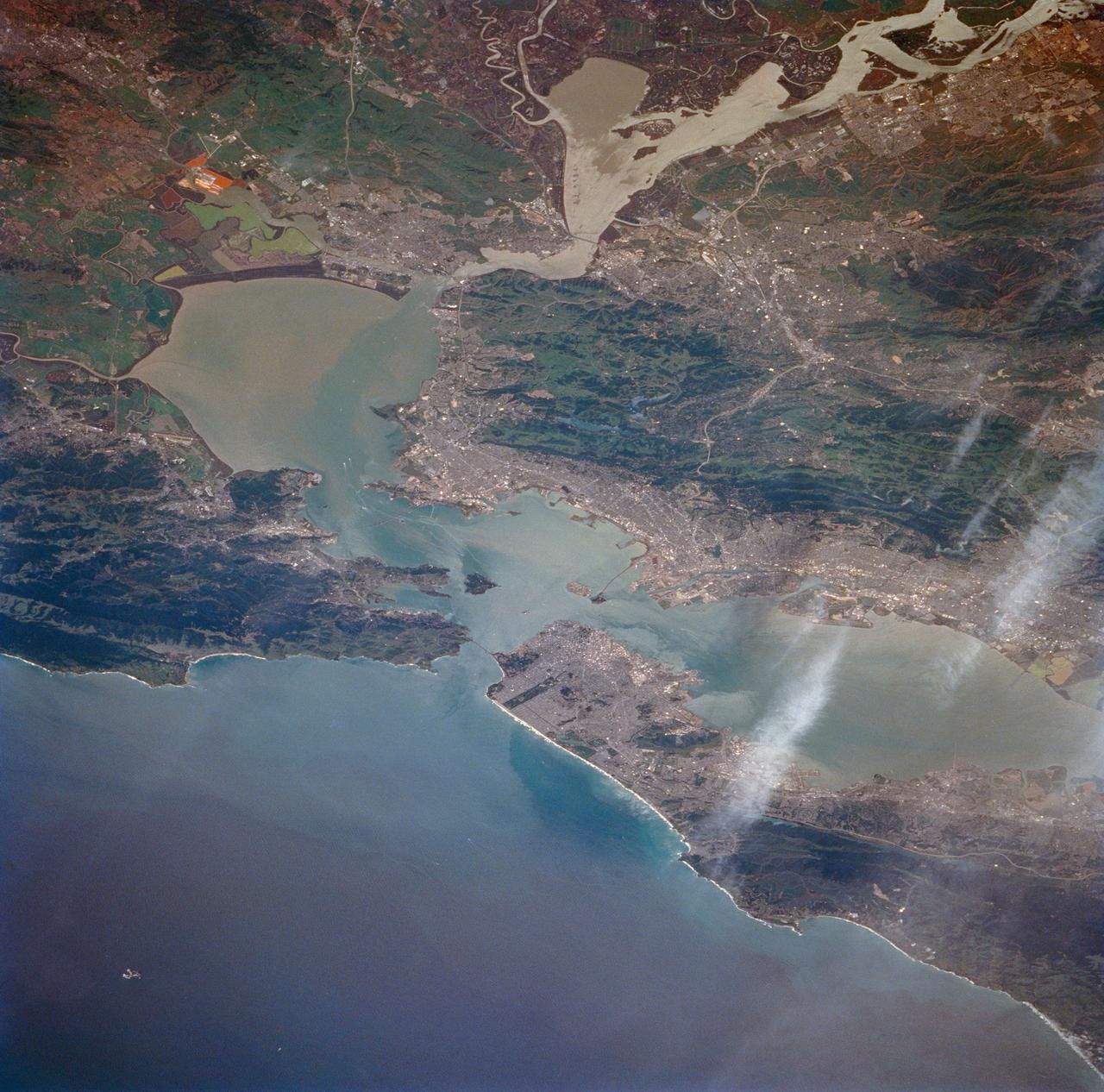
STS059-213-009 (9-20 April 1994) --- San Francisco Bay. Orient with the sea up. The delta of the combined Sacramento and San Joaquin Rivers occupies the foreground, San Francisco Bay the middle distance, and the Pacific Ocean the rest. Variations in water color caused both by sediment load and by wind streaking strike the eye. Man-made features dominate this scene. The Lafayette/Concord complex is left of the bay head, Vallejo is to the right, the Berkeley/Oakland complex rims the shoreline of the main bay, and San Francisco fills the peninsula beyond. Salt-evaporation ponds contain differently-colored algae depending on salinity. The low altitude (less than 120 nautical miles) and unusually-clear air combine to provide unusually-strong green colors in this Spring scene. Hasselblad camera.
AS09-23-3566 (3-13 March 1969) --- Near vertical view of the Birmingham, Alabama area extending to Gadeden, as photographed from the Apollo 9 spacecraft during its Earth-orbital mission. The city spreads out between ridges of the folded southern Appalachian Mountains. The major stream in the picture is the Coosa River.

The greater New Orleans area, including portions of Louisiana and Mississippi, as seen from the Apollo 7 spacecraft during its 120th revolution of the earth. Photographed from an altitude of 95 nautical miles, at ground elapsed time of 190 hours and 45 minutes. The largest body of water in the picture is Lake Pontchartrain. The Mississippi River is clearly visible as it meanders past New Orleans. Note highway network, and 25-mile causeway across lake.
SL4-142-4577 (28 Jan. 1974) --- Two large ice islands in the vicinity of South Georgia Island in the South Atlantic Ocean, as photographed from the Skylab space station in Earth orbit by one of the Skylab 4 crewmen. The camera used was a hand-held 70mm Hasselblad, with SO-368 medium-speed Ektachrome. One of the ice islands is partially obscured by clouds. Ice islands were observed as large as 45 by 60 kilometers (27 x 37 miles) and as far north as 45 degrees south latitude. The size and distribution of the "small" icebergs (to a ship they would look very large) can be used to study the local winds and currents. Recent research has suggested the possibility of towing such Antarctic icebergs to selected areas and using them as water supplies. One such iceberg would contain many times the water as in Lake Powell. Photo credit: NASA
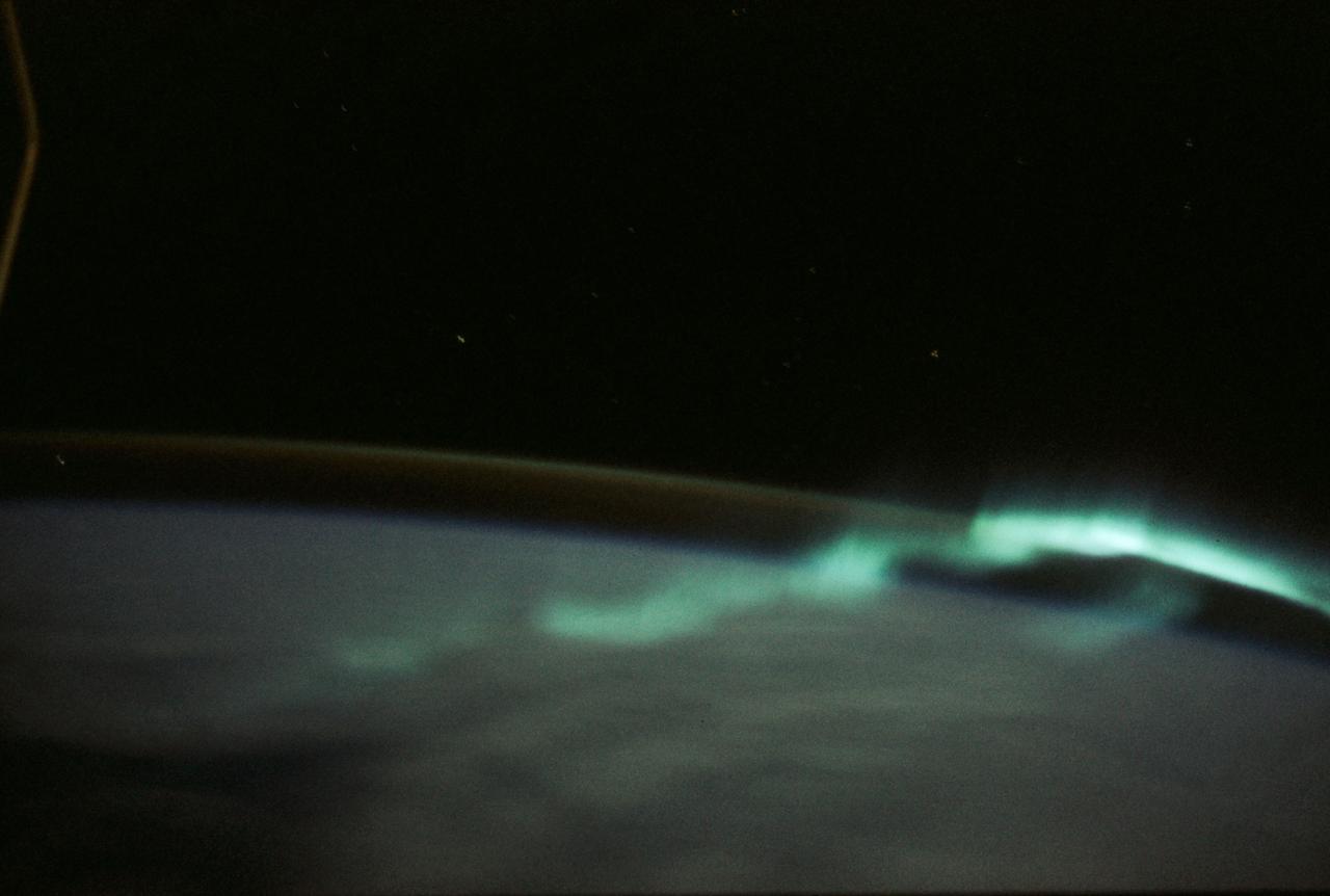
STS062-58-025 (4-18 March) --- This photo shows the aurora australis or souther lights. The multi-hued shafts of light, extending upward to 200 miles above the earth's surface, are caused by beams of energetic electrons colliding with the oxygen and nitrogen in the earth's upper atmosphere. The strong red glow occurs at the highest altitude where the air is least dense and composed mostly of oxygen. At lower altitudes, the greater density favors the green color, also produced by atomic oxygen. Sometimes at the bottom (the lowest altitude of the aurora) a pink border is produced by nitrogen. The aurora usually can be seen only in Arctic regions. However, because of the tilt of the magnetic axis of the space shuttle mission orbits. One of these regions is over eastern North American, and the second one is south of Australia. Since most shuttle launches occur in daytime, the North American region is in daylight, and the only auroras that can be seen are usually in the Southern Hemisphere.
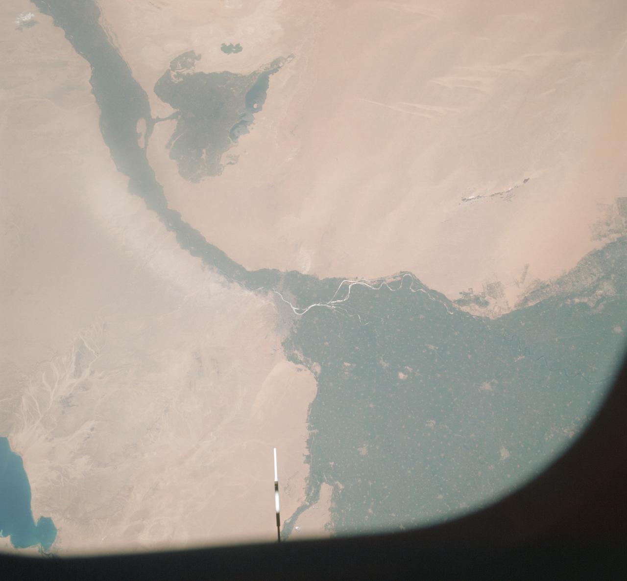
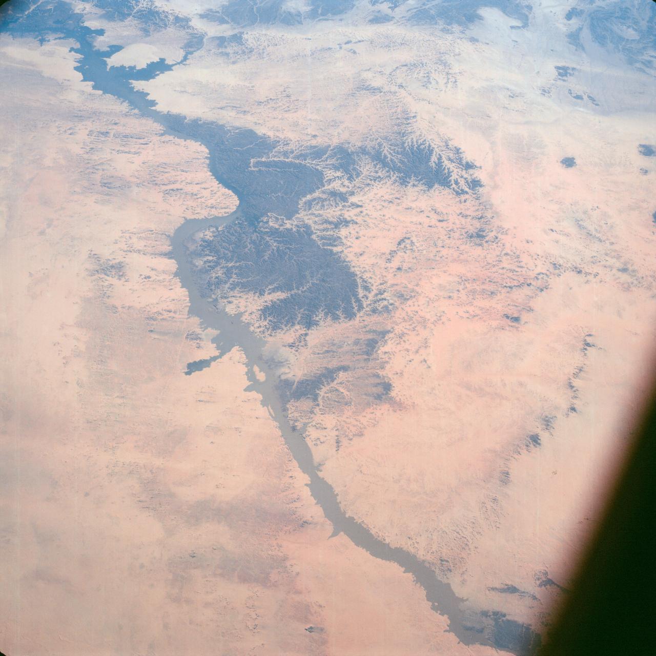
AST-09-555 (19 July 1975) --- A vertical view of a portion of the Arab Republic of Egypt, as photographed from the Apollo spacecraft in Earth orbit during the joint U.S.-USSR Apollo-Soyuz Test Project mission. The Nile Delta is in the most northerly corner of the picture. The City of Cairo on the Nile River is in the center of the photograph. The Gulf of Suez is in the most easterly corner of the picture. El Faiyum is south-southwest of Cairo. This picture was taken at an altitude of 223 kilometers (138 statute miles), with a 70mm Hasselblad camera using medium-speed Ektachrome QX-807 type film.
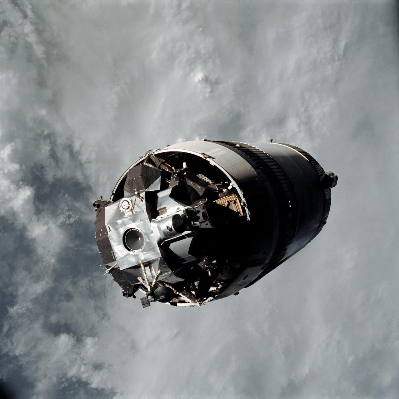
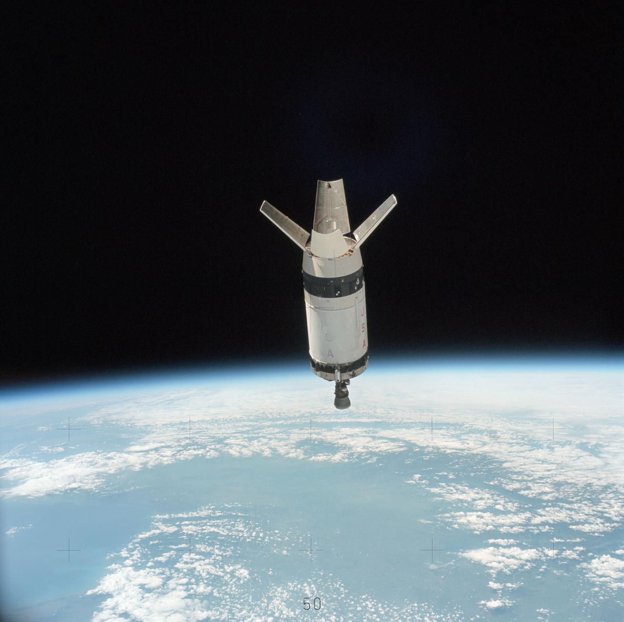
AS09-19-2919 (3 March 1969) --- The Lunar Module (LM) "Spider", still attached to the Saturn V third (S-IVB) stage, is photographed from the Command and Service Modules (CSM) "Gumdrop" on the first day of the Apollo 9 Earth-orbital mission. This picture was taken following CSM/LM-S-IVB separation and prior to LM extraction from the S-IVB. The Spacecraft Lunar Module Adapter (SLA) panels have already been jettisoned. Inside the Command Module were astronauts James A. McDivitt, commander; David R. Scott, command module pilot; and Russell L. Schweickart, lunar module pilot.
AST-14-890 (18 July 1975) --- An oblique view of unique drainage patterns in southwestern Africa in the Rio Cuando area of Angola and South-West Africa, as photographed from the Apollo spacecraft in Earth orbit during the joint U.S.-USSR Apollo-Soyuz Test Project mission. The picture was taken at an altitude of 223 kilometers (138 statute miles) with a 70mm Hasselblad camera using high-definition Ektachrome aerial SO-242 type film.
S65-63797 (12 Dec. 1965) --- Polaris, underwater launch, missile and trail, off Florida, as seen from the Gemini-7 spacecraft during its 31st revolution of Earth. Photo credit: NASA
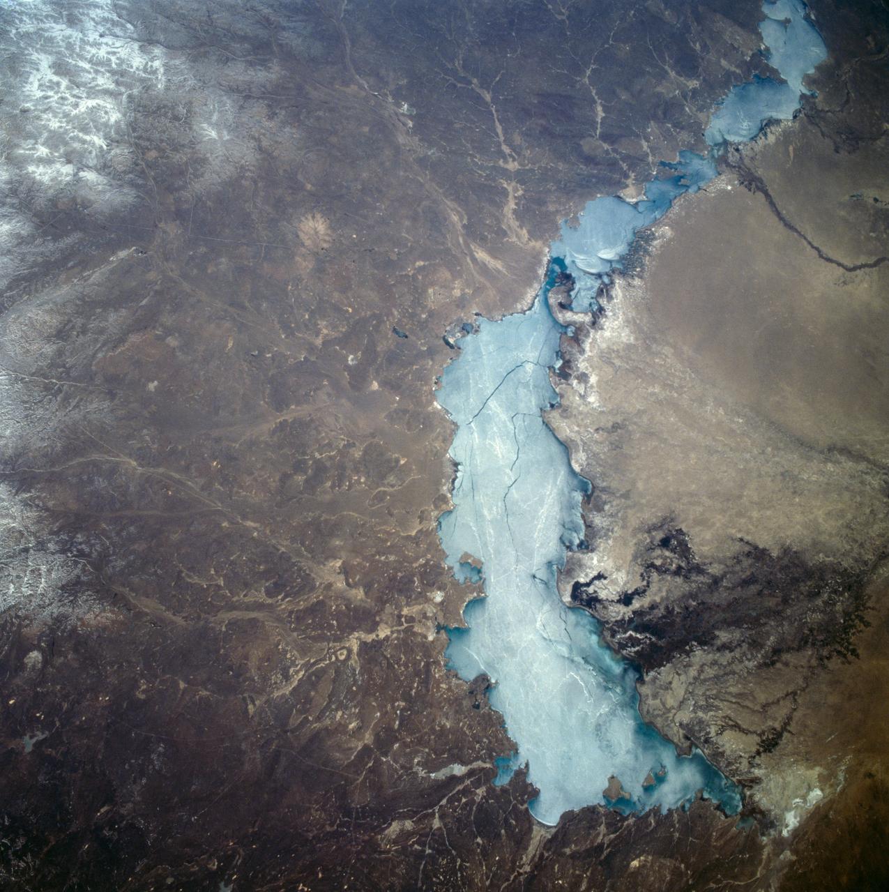
STS059-209-081 (9-20 April 1994) --- Lake Balkhash, in eastern Kazakhstan, is some 300 miles long. The lake, frozen in this scene, thawed noticeably during the mission. The shape of the lake is controlled by the delta of the Ili River, which flows from the Tien Shan Mountains in western China across this arid steppe. SRL scientists will use radar data to study the microwave effects of differences in soil moisture, and in freezing or thawing, on the deltaic sediments. Hasselblad camera.
AST-19-1550 (24 July 1975) --- A vertical view of the Lake Eyre Basin area in the state of South Australia in Australia, as photographed from the Apollo spacecraft in Earth orbit during the joint U.S.-USSR Apollo-Soyuz Test Project mission. The picture was taken at an altitude of 241 kilometers (150 statute miles) with a 70mm Hasselblad camera using medium-speed Ektachrome QX-807 type film.
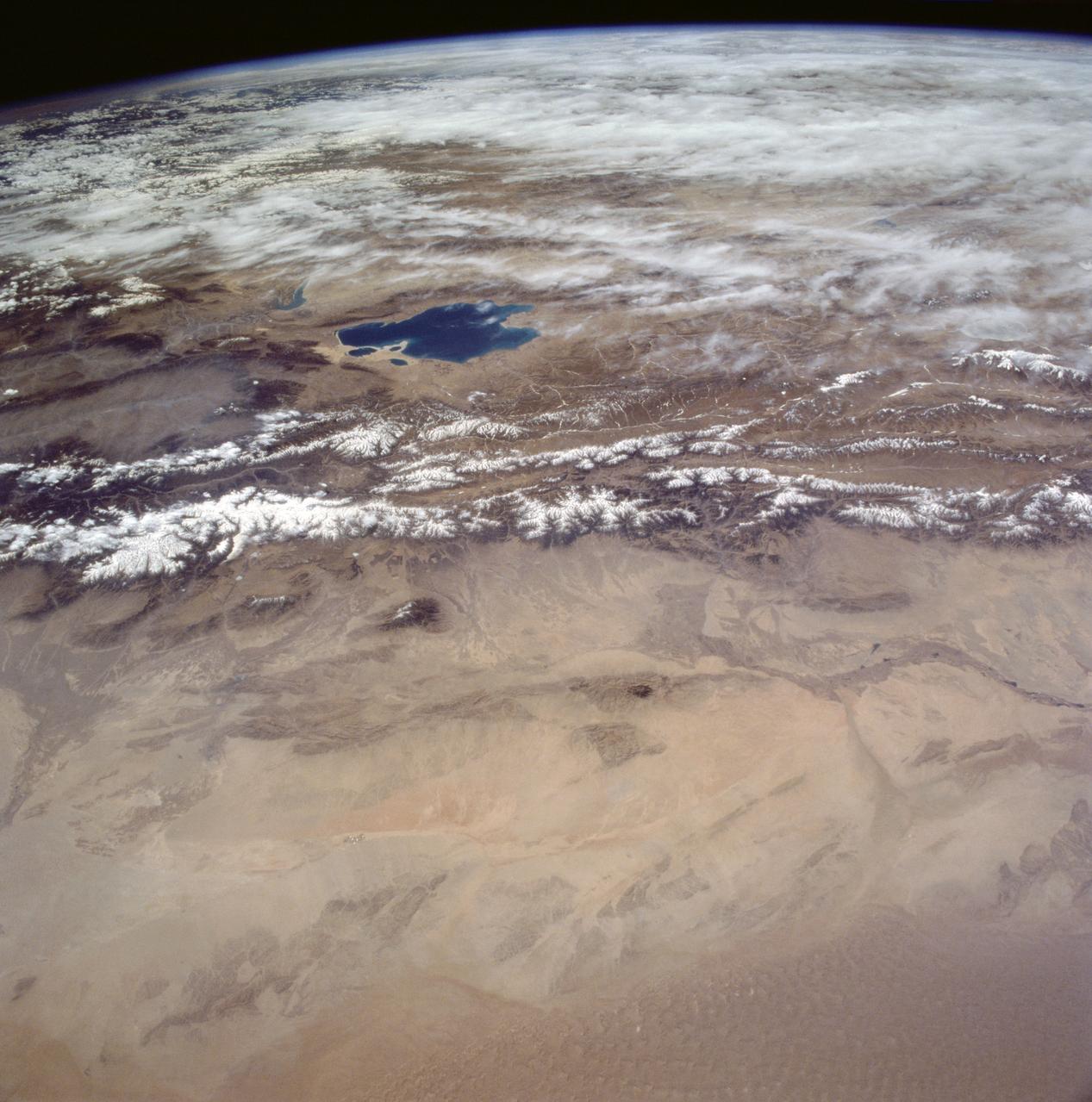
STS058-95-028 (18 Oct-1Nov 1993) --- Lake Urmia (Orumiyeh) in the high desert plateau of northwest Iran dominates the center of this northeast-looking view. The left edge of the view cuts Lake Van in eastern Turkey. The Caucasus Mountains in war-torn Georgia appear just beyond. Mount Ararat, of biblical fame, is a major peak north of Lake Van. The Caspian Sea, an international body of water, stretches across the top right of the view. Countries bordering the Caspian are Iran in the south, Kazakhstan in the west, and Russia and Azerbaijan in the west.
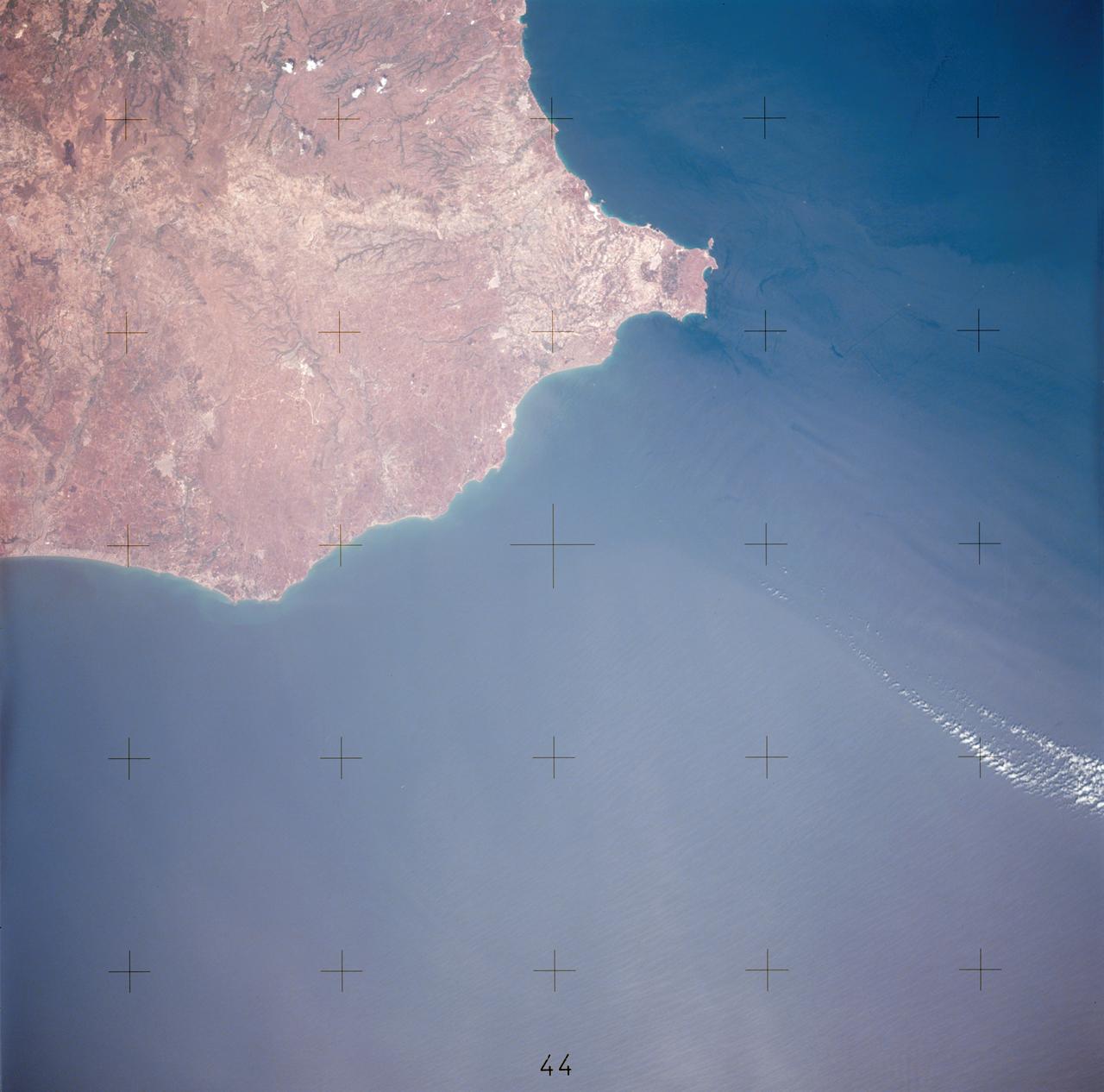
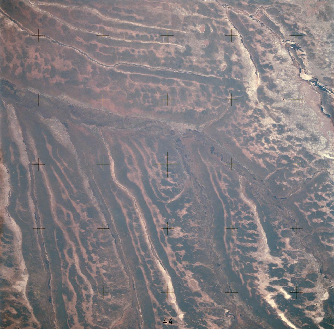
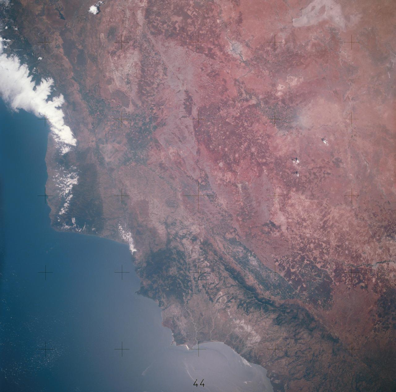
STS058-72-004 (18 Oct-1 Nov 1993) --- The Sierra Nevada Mountain Range can be seen in this north-looking high oblique view taken in October, 1993, by the STS-58 crew. Visible in the view to the west of the Sierra Nevada are the San Joaquin and Sacramento Valleys of central California. The San Francisco/Oakland Bay Area can be seen to the west of the valley at the extreme left of the photograph. To the east or right of the Sierra Nevada, the basin and Range Region of central and northern Nevada is visible. Mono Lake, Lake Tahoe and Pyramid Lake are also visible in this scene. The long northwest/southeast trending Walker Lane Shear Zone, which lies just to the east (right) of the Sierra Nevada is also visible. Near the top of the view (near the horizon), the snow covered volcanic peak Mount Shasta can be seen. Over 645 kilometers (400 miles) long and from 65 to 130 kilometers (40 to 80 miles) wide, the Sierra Nevada have many peaks in excess of 3,300 meters (11,000 feet) above sea level. A titled fault block in structure (the largest in the United States) and shaped by glaciers during the last ice age over 12,000 years ago, the Sierra Nevada eastern front rises sharply from the Great Basin of Nevada, while its western slope descends gradually to the hills bordering the Central Valley of California. Snow-fed streams supply much of the irrigation water to the Central Valley and to western Nevada and also generate hydroelectricity. Recent above normal precipitation (snowfall) of the last two years has helped in alleviating the drought conditions that had prevailed throughout most of California in the mid and late 1980's and early 1990's.
STS058-102-018 (18 Oct-1 Nov 1993) --- A cloud-free, wide-angle view from above western Tennessee to the northern edge of Lake Michigan. The view extends from Saint Louis, Missouri near the lower left-hand corner, past Evansville, Indiana and Louisville, Kentucky to Cincinnati, Ohio. A range of hills covered by trees in Fall foliage extends from the Ohio River toward Lake Michigan, ending just southwest of Indianapolis, Indiana.

AS09-22-3436 (March 1969) --- Los Angeles-Long Beach area of southern California, as photographed from the Apollo 9 spacecraft during its 92nd revolution of Earth. Santa Catalina Island is located off the coast. The California coastline is visible from San Clemente northward to Point Dume. Clouds cover most of the San Gabriel Mountains around Los Angeles.
AS09-22-3341 (3-13 March 1969) --- Central Texas area as photographed from the Apollo 9 spacecraft during its Earth-orbital mission. Interstate 35 runs from Austin (right center edge of picture) to Waco (near bottom left corner). Also visible are the cities of Georgetown, Taylor, Temple and Killeen. The Colorado River runs through Austin. The Brazos River flows through Waco. Lake Travis is upstream from Austin. Lake Whitney is at bottom left corner of picture. The Belton Reservoir is near bottom center. The lake formed by the dam on the Lampasas River near Belton is also clearly visible.
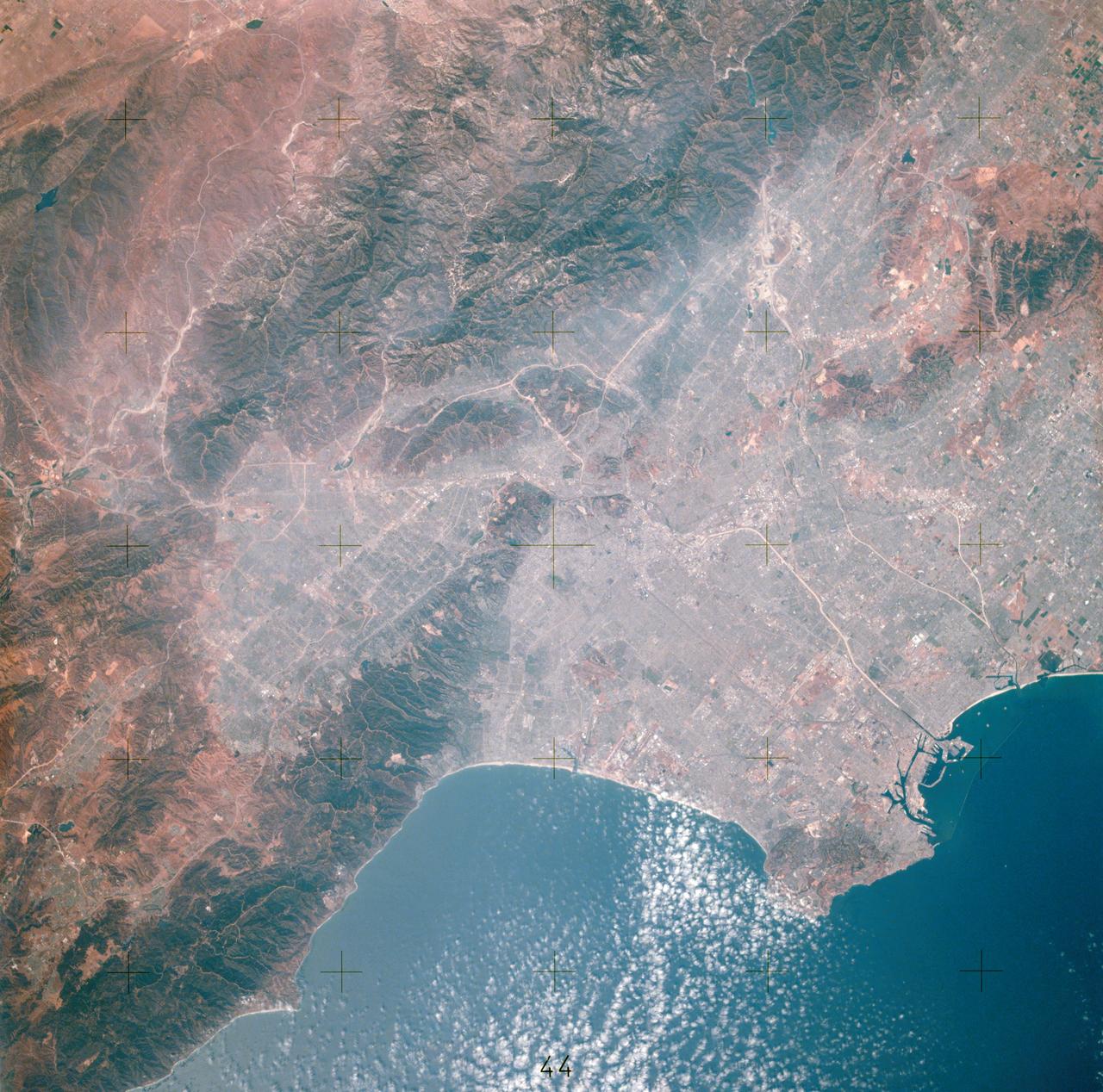
AST-14-881 (16 July 1975) --- An excellent view of Los Angeles, California, as photographed from the Apollo spacecraft in Earth orbit during the joint U.S.-USSR Apollo-Soyuz Test Project (ASTP) mission. Downtown Los Angeles is near the center of the picture. The photograph was taken at an altitude of 193 kilometers (120 statute miles), with a 70mm Hasselblad camera using SO-242 high-definition Ektachrome film.
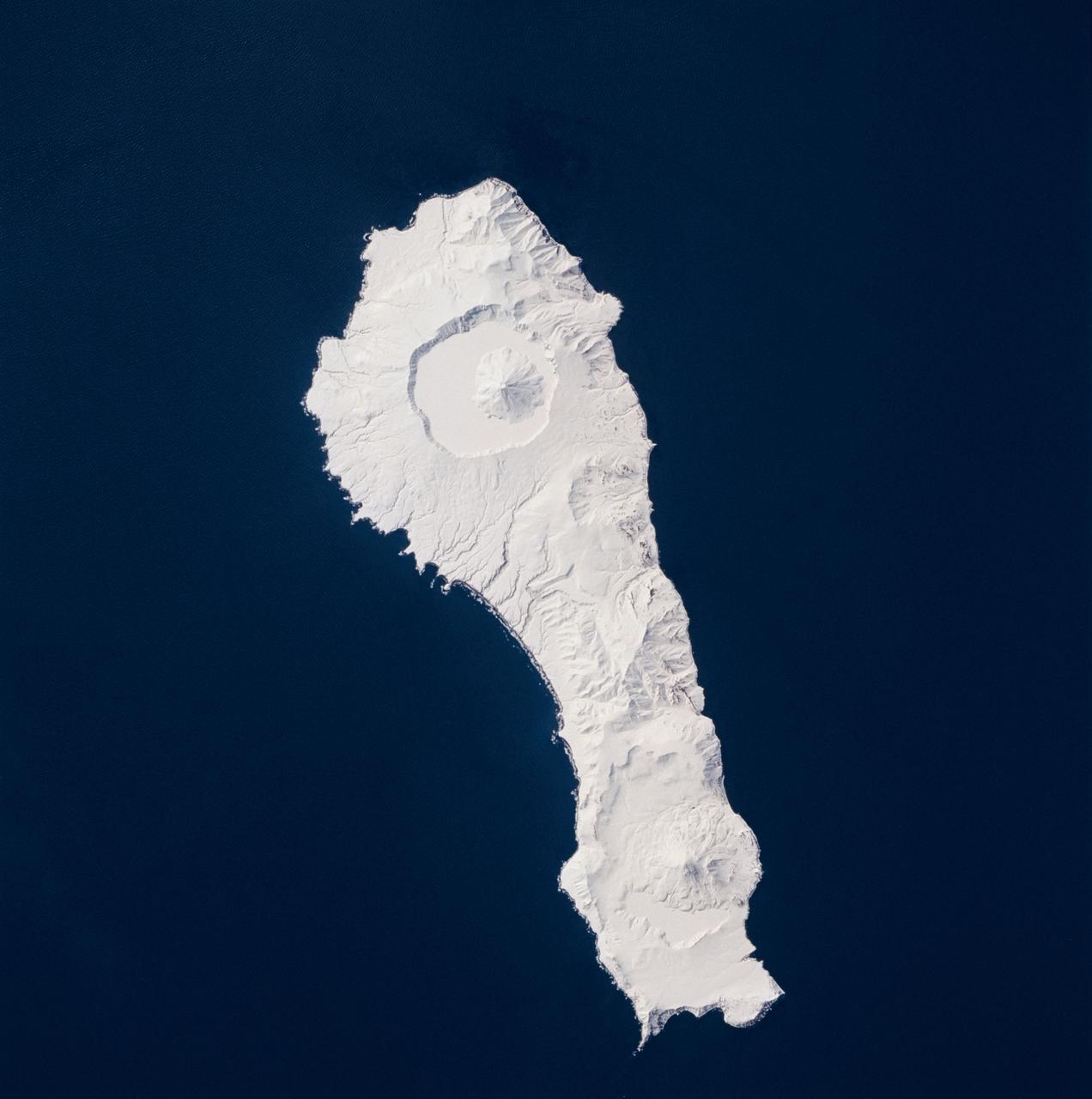
STS059-219-065 (9-20 April 1994) --- The narrow end of the island is to the north by northeast. This is one of several volcanic islands extending south by southwest between the southern tip of Kamchatka and Japan. The exposure was stopped down to provide extremely fine detail in the totally snow-covered landscape, at the same time making the dark sea look completely black. Compare to STS047-90-087, taken in September, which shows a green ground cover. Hasselblad photograph.
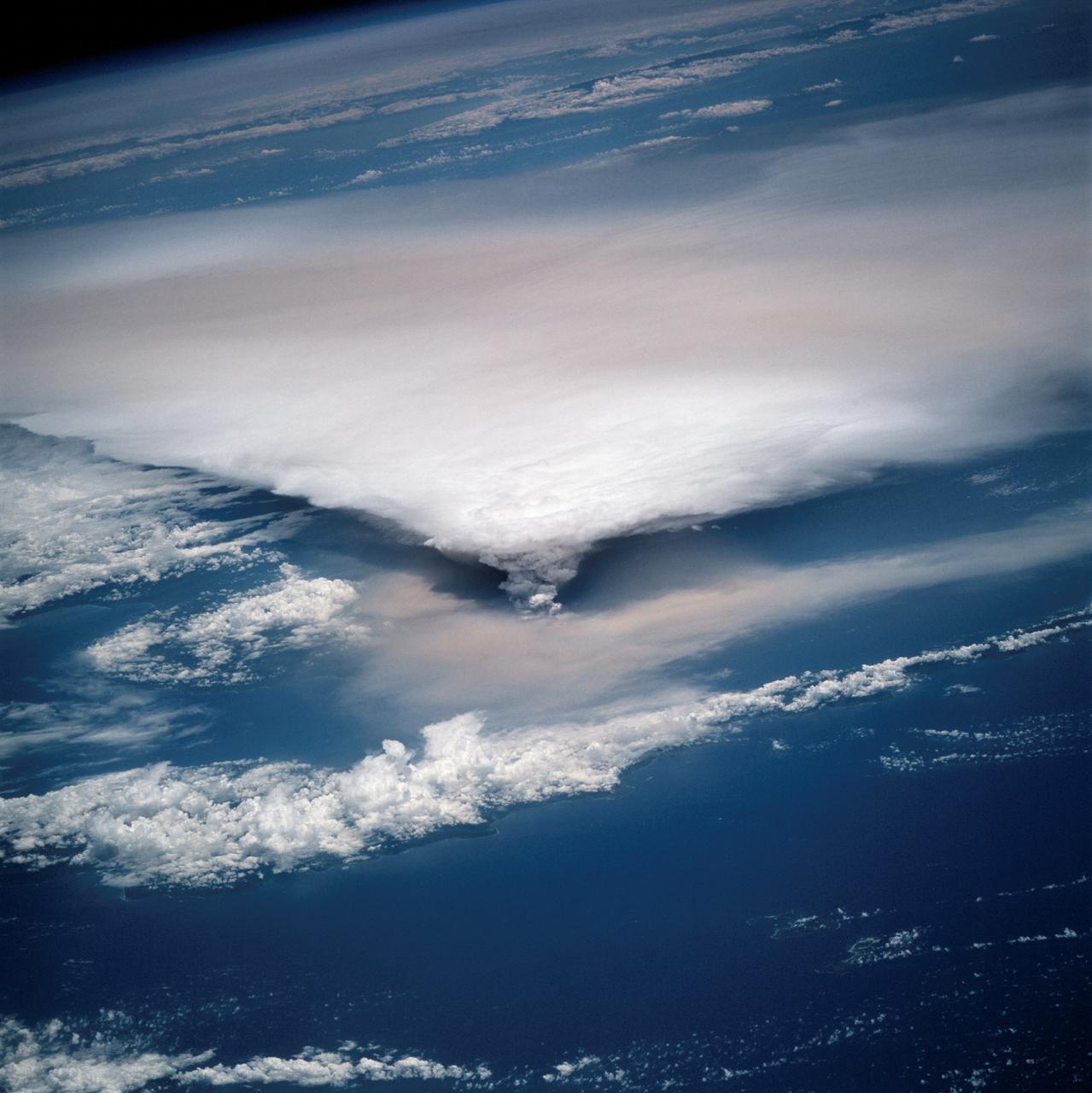
STS064-116-064 (20 Sept. 1994) --- Near the end of the mission, the crew aboard space shuttle Discovery was able to document the beginning of the second day of activity of the Rabaul volcano, on the east end of New Britain. On the morning of Sept. 19, 1994, two volcanic cones on the opposite sides of the 6-kilometer sea crater had begun to erupt with very little warning. Discovery flew just east of the eruption roughly 24 hours after it started and near the peak of its activity. New Ireland, the cloud-covered area in the foreground, lies just east of Rabaul harbor. The eruption, which sent a plume up to over 60,000 feet into the atmosphere, caused over 50,000 people to evacuate the area. Because winds were light at the time of the eruption, most of the ash was deposited in a region within 20 kilometers of the eruption zone. This photo shows the large white billowing eruption plume is carried in a westerly direction by the weak prevailing winds. At the base of the eruption column is a layer of yellow-brown ash being distributed by lower level winds. A sharp boundary moving outward from the center of the eruption in the lower cloud is a pulse of laterally-moving ash which results from a volcanic explosion. Geologists theorize that the large white column and the lower gray cloud are likely from the two main vents on each side of the harbor. The bay and harbor of Rabaul are covered with a layer of ash, possibly partly infilled with volcanic material. Matupit Island and the airport runway have disappeared into the bay. More than a meter of ash has fallen upon the city of Rabaul. Up to five vents were reported to have erupted at once, including the two cones Vulcan and Tavurvur, which are opposites of the harbor as well as new vents below the bay. Half of the Vulcan cone has collapsed into the sea. The extra day in space due to bad weather at the landing site afforded the crew the opportunity for both still and video coverage of the event. Photo credit: NASA or National Aeronautics and Space Administration
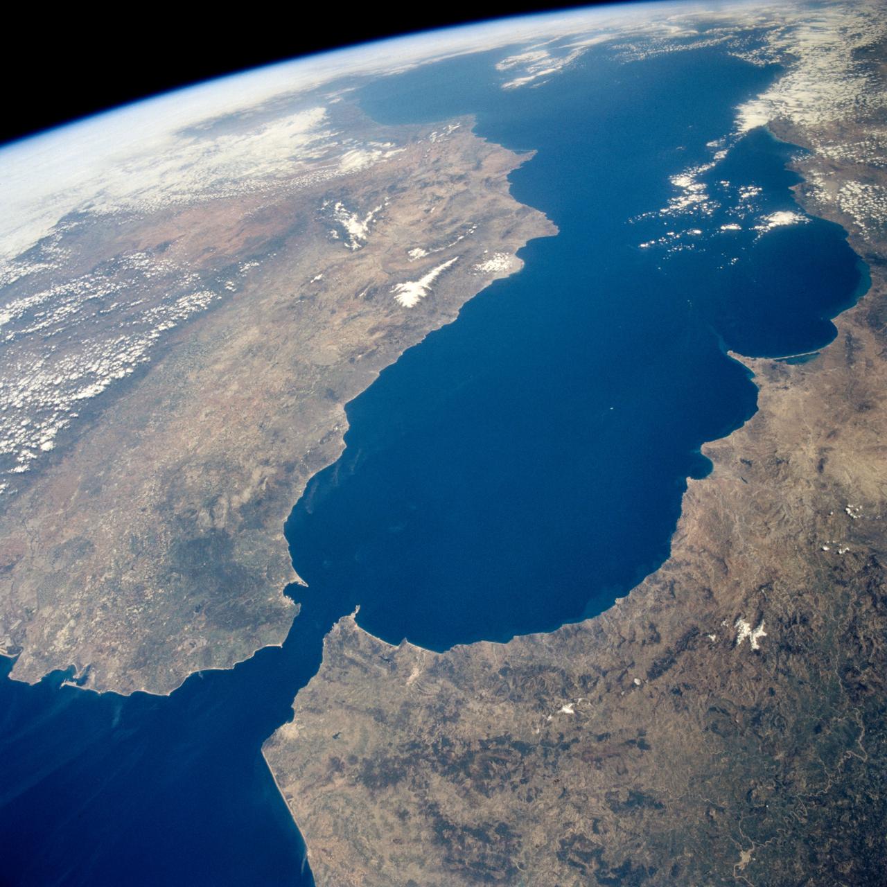
STS059-238-074 (9-20 April 1994) --- The Atlantic Ocean, Straits of Gibraltar, and Alboran Sea (the westernmost portion of the Mediterranean Sea) separate Spain on the left from Morocco on the right. Algeciras Harbor is the prominent notch cut out of the eastern end of the north shore of the Strait; the Rock of Gibraltar is the tiny arrowhead that separates the notch from the Alboran Sea. The Sierra Nevada, farther away down the Spanish coast, lives up to its name in this April scene. The difference in elevation between the Sierra Morena and the Guadalquivir River valley is highlighted nicely by cumulus clouds. Tangier, Morocco can be seen as a light-toned spot on the southern shore of the Strait, near the entrance to the Atlantic Ocean. Hasselblad photograph.
STS059-86-059 (9-20 April 1994) --- This oblique handheld Hasselblad 70mm photo shows Death Valley, near California's border with Nevada. The valley -- the central feature of Death Valley National Monument -- extends north to south for some 140 miles (225 kilometers). Hemmed in to the east by the Amargosa Range and to the west by the Panamints, its width varies from 5 to 15 miles (8 to 24 kilometers). Using Spaceborne Imaging Radar (SIR-C) and X-band Synthetic Aperture Radar (X-SAR) onboard the Space Shuttle Endeavour, the crew was able to record a great deal of data on this and other sites, as part of NASA's Mission to Planet Earth.

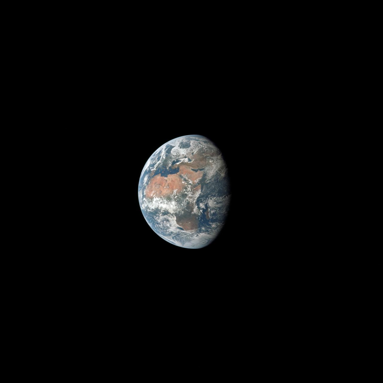
AS8-15-2561 (21-27 Dec. 1968) --- View of Earth as photographed by the Apollo 8 astronauts on their return trip from the moon. Note that the terminator is straighter than on the outbound pictures. The terminator crosses Australia. India is visible. The sun reflection is within the Indian Ocean.
AST-19-1555 (24 July 1975) --- A sunglint in the South Western Pacific Ocean, as photographed from the Apollo spacecraft in Earth orbit during the joint U.S.-USSR Apollo-Soyuz Test Project mission. The island is Bougainville of the Solomon Islands group. The horizon of Earth is in the background. The picture was taken at an altitude of 231 kilometers (143 statute miles), with a 70mm Hasselblad camera using medium-speed Ektachrome QX-807 type film.

AST-02-130 (20 July 1975) --- An oblique view of a portion of Libya and the Arab Republic of Egypt, as photographed from the Apollo spacecraft in Earth orbit during the joint U.S.-USSR Apollo-Soyuz Test Project mission. The geological features are the Jebel Uweinat and Jebel Arkenu basaltic mountains in the Libyan sand sea. This picture was taken with a 70mm Hasselblad camera using medium-speed Ektachrome QX-807 type film. The spacecraft was at an altitude of 219 kilometers (136 statute miles).
SL4-140-4110 (January 1974) --- View of the USSR, Siberia area from Skylab 4. Other areas seen are Ozero, Kanka, Ussiriysk, the Sea of Japan and Kavalerovo (45.5N, 135.5E). Photo credit: NASA
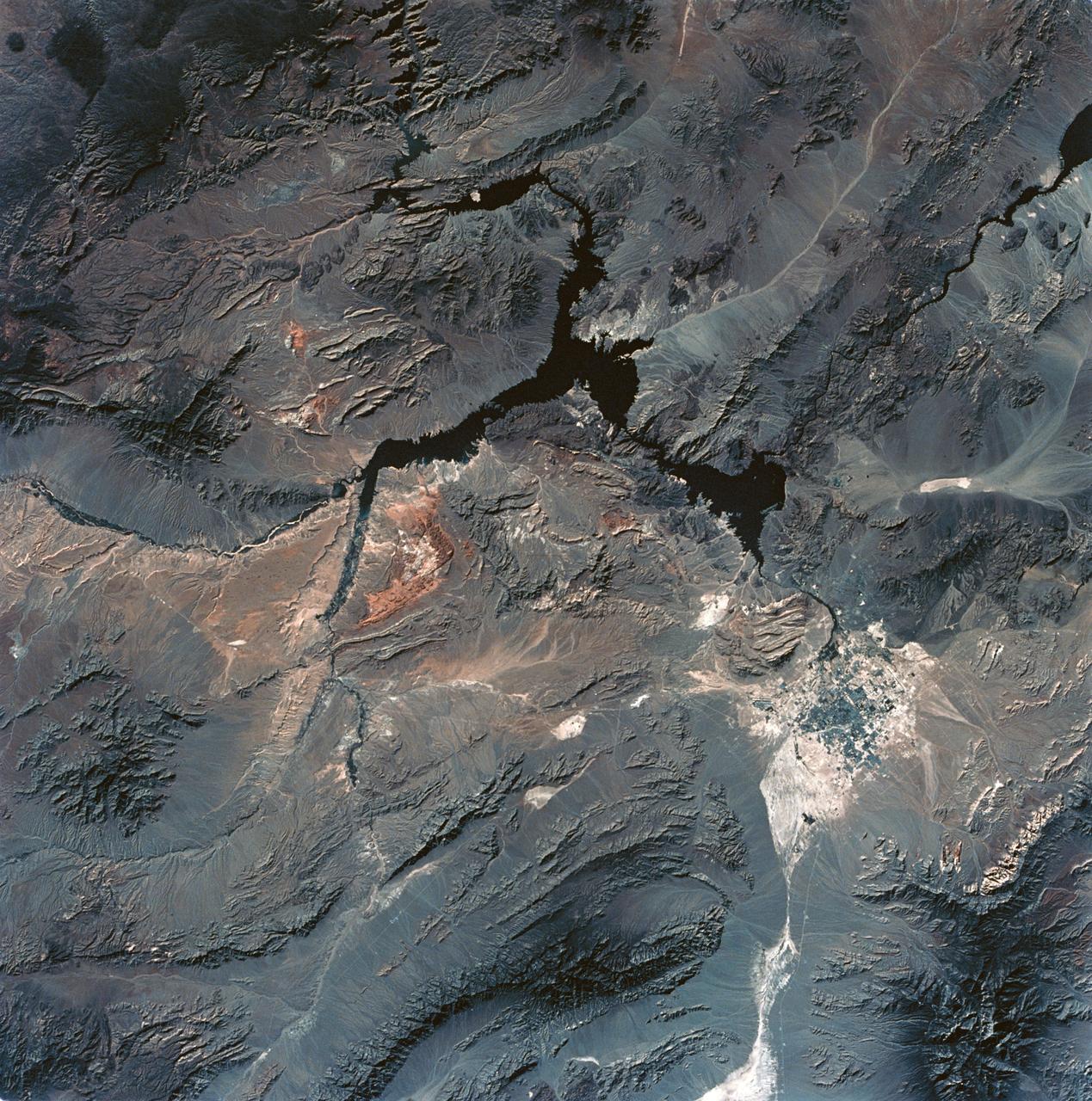
SL3-28-059 (July-September 1973) --- A vertical view of the Lake Mead and Las Vegas, Nevada area as photographed from Earth orbit by one of the six lenses of the Itek-furnished S190-A Multispectral Photographic Facility Experiment aboard the Skylab space station. Lake Mead is water of the Colorado River impounded by Hoover Dam. Most of the land in the picture is Nevada. However, a part of the northwest corner of Arizona can be seen. Federal agencies participating with NASA on the EREP project are the Departments of Agriculture, Commerce, Interior, the Environmental Protection Agency and the Corps of Engineers. All EREP photography is available to the public through the Department of Interior?s Earth Resources Observations Systems Data Center, Sioux Falls, South Dakota, 57198. Photo credit: NASA
STS058-107-046 (18 Oct-1 Nov 1993) --- Clouds streak across central Florida in this striking photograph which includes the Florida Peninsula, Andros Island of the northern Bahamas and Cuba (lower left). The light blue, shallow bank of the Bahamas contrast with the deeper blue waters of the Florida strait. The city of Miami is obscured by clouds, but one can see the Florida Keys stretching off to the left. Much of the rest of the southeast coast is barely visible under haze.
AST-16-1268 (20 July 1975) --- A near vertical view of a portion of the Mediterranean coast of Turkey and Syria, as photographed from the Apollo spacecraft in Earth orbit during the joint U.S-USSR Apollo-Soyuz Test Project mission. This view covers the Levant Coast north of Beirut, showing the cities of Aleppo, Hamah, Homs and Latakia. The Levantine rift bends to the northeast. This picture was taken with a 70mm Hasselblad camera using high-definition aerial Ektachrome SO-242 type film. The altitude of the spacecraft was 225 kilometers (140 statute miles) when this photograph was taken.
AS07-07-1832 (15 Oct. 1968) --- Toba, Kakar, Fort Sandeman, Sulaiman Range area in (West) Pakistan, as seen from the Apollo 7 spacecraft during its 84th revolution of Earth. Note geological features such as folded mountain structures, anticlines and synclines. Photographed from an altitude of 108 nautical miles, at ground elapsed time of 132 hours and 30 minutes.
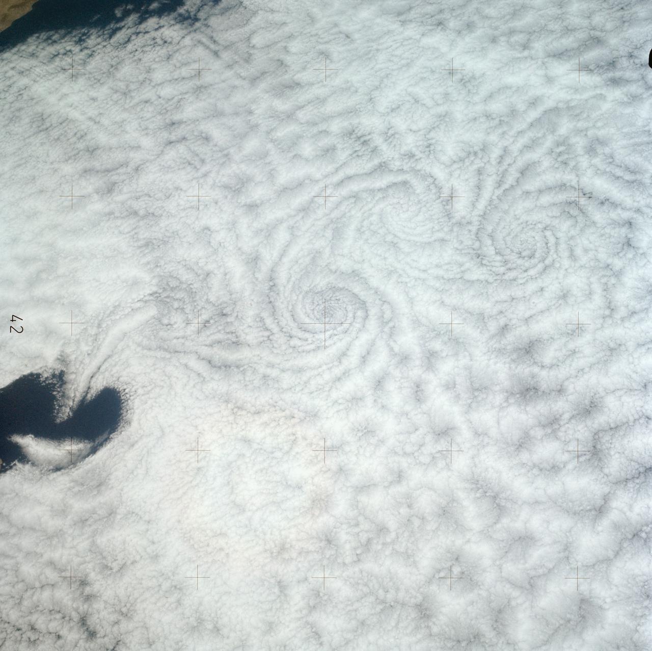
AS07-05-1644 (13 Oct. 1968) --- Remarkable cloud patterns as seen from the Apollo 7 spacecraft during its 34th revolution of Earth. Note break in two adjacent decks of strato-cumulus cloud formations. Sea can be seen through holes in clouds.
AST-30-2601 (20 July 1975) --- An area of the Cascade Mountains southeast of Seattle in the State of Washington, as photographed from the Apollo spacecraft in Earth orbit during the joint U.S.-USSR Apollo-Soyuz Test Project mission. The view includes Snoqualmie Pass, Cle Elum Lake, Kachess Lake and Keechelus Lake. The picture was taken at an altitude of 228 kilometers (141 statute miles) with a 70mm Hasselblad camera using medium-speed Ektachrome QX-807 type film.
SL3-121-2371 (July-September 1973) --- A pattern of downstream eddies in the stratocumulus clouds over the Pacific Ocean west of Baja California, as photographed by the crewmen of the second Skylab manned mission (Skylab 3) from the space station cluster in Earth orbit. The clouds, produced by the cold California current running to the south and southwest, are prevented from rising by warm air above them. Photo credit: NASA
S65-63826 (5 Dec. 1965) --- Oriente Province, eastern end of Cuba, as seen from the National Aeronautics and Space Administration's Gemini-7 spacecraft during its 14th revolution of Earth. Guantanamo Bay is in the center of the picture on the southern coast of Cuba. Santiago de Cuba is located about one inch from the bottom edge of the picture, or about three inches westward down the coast from Guantanamo. This photograph was taken with a modified 70mm Hasselblad camera, using Eastman Kodak, Ektachrome MS (S.O. 217) color film. Photo credit: NASA
S65-63926 (16 Dec. 1965) --- Island of Hispaniola, Dominican Republic end, as seen from the National Aeronautics and Space Administration's Gemini-7 spacecraft during its 179th revolution of Earth. North is toward the left of the picture. This photograph was taken with a modified 70mm Hasselblad camera, using Eastman Kodak, Ektachrome MS (S.O. 217) color film. Photo credit: NASA
STS058-91-074 (18 Oct-1 Nov 1993) --- The largest cityscape in the view is Nashville (top left), part of which is obscured under a band of clouds (the Cumberland River, on which Nashville lies, can not be seen under the cloud band). Close to the main cloud mass on the opposite side of the view, lies a small lake (Normandy Lake in sunglint (right center) 70 miles southeast of Nashville. Between these two features, in the center of the Nashville Basin, lies the city of Murfreesboro. The city appears here as a spider like pattern one third the distance from Nashville towards Normandy Lake. The Tennessee River can be seen bottom right and top right through holes in the cloud.
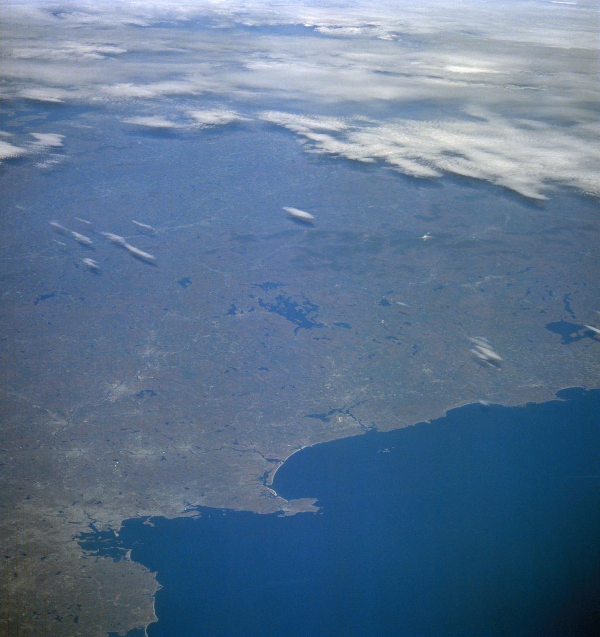
STS061-106-091 (December 1993) --- The entire southern tip of Africa is shown in this high altitude 50mm photograph. The center of the photograph is at approximately 28.0 degrees south and 24.0 degrees east Cape Columbine is at the upper right with Durban at the lower center. The Orange River is at the upper center of the frame. Cape Agulas is the southernmost part of the African continent and is visible toward the upper right corner with the great bays of South Africa trending toward the bottom right. Continuing clockwise along the coast, Durban projects out into the Indian Ocean. The oceanic clouds on the right side of the photograph probably depict a current boundary. The Drakensberg Range on the east, the great Karoo Range to the south and the Karas Mountains on the west surround the drier central plateau. The southern Kalahari Desert is at the upper left of the photograph.
STS058-085-091 (18 Oct-1 Nov 1993) --- Yellowstone Lake and the surrounding Plateau are centered in this scene of northwestern Wyoming, and adjacent Idaho and Montana. The view extends across the Absaroka Range to Billings, on the Yellowstone River at the upper right edge of the photograph. Jackson Lake, Jackson Hole (valley) and the Grand Tetons extend from the Yellowstone Plateau toward the camera.
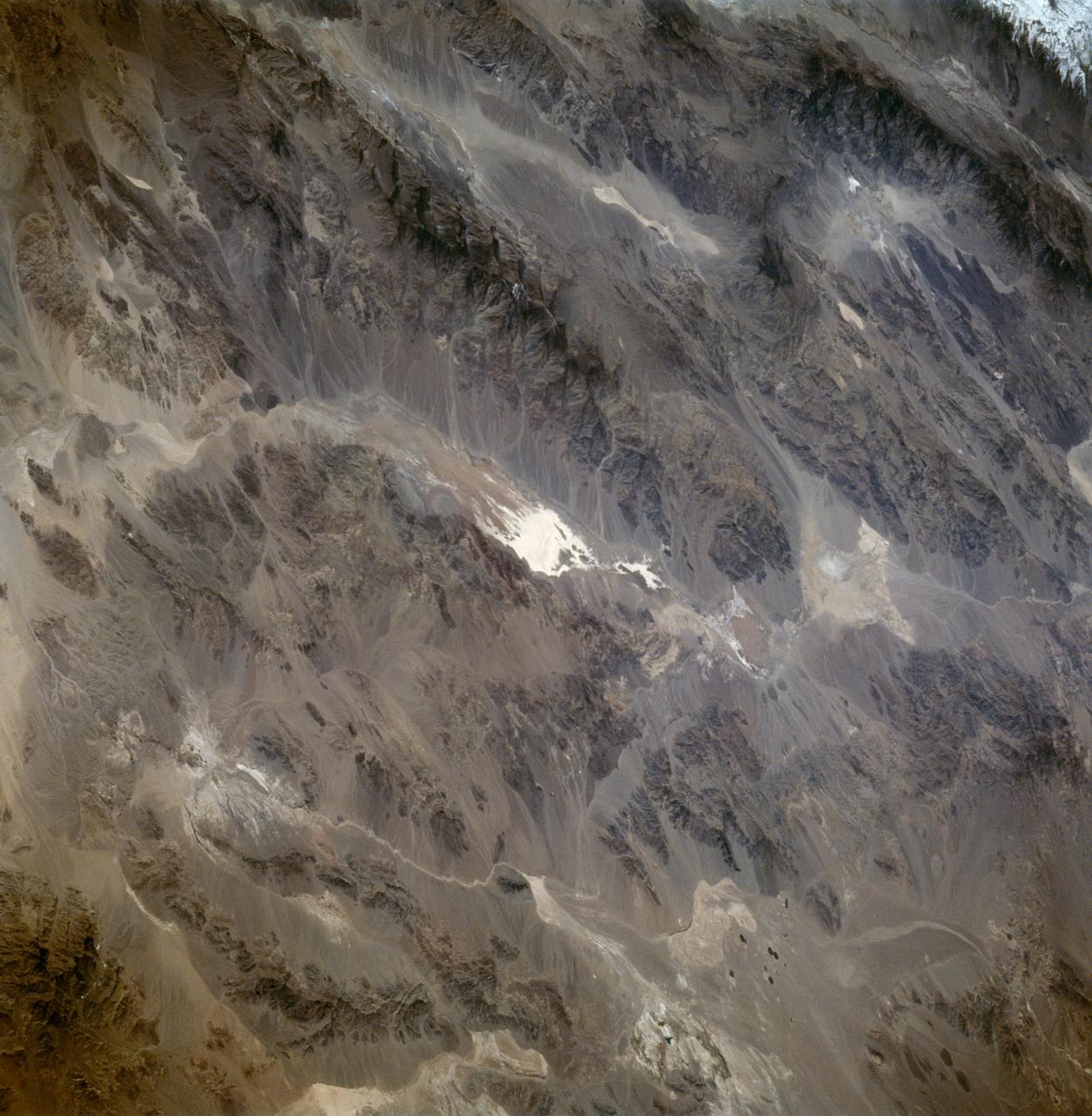
AS07-04-1593 (21 Oct. 1968) --- This Earth observation photograph shows Argentina, Chile, Bolivia, Salar de Atacama, the Andes Mountains, and Gran Chaco. The coordinates for the center of this photograph are 23.00 degrees south and 67.30 degrees west, taken at an altitude of 175 miles during the 154th revolution around Earth. The crew consisted of astronauts Walter M. Schirra, Donn F. Eisele and Walter Cunningham.
STS058-89-013 (18 Oct-1 Nov 1993) --- An oblique westward view, across the wheat fields and cattle pastures, of eastern Colorado to the Front Range of the Rocky Mountains. Denver is bisected at the center of the right edge of the frame. Pikes Peak and Colorado Springs are left of center, and the Arkansas River Valley with Canyon City and the Royal Gorge are along the left edge of the frame. This view shows the startling contrast between the nearly-flat High Plains and the ancient geological uplift of the Rockies.
STS058-105-016 (18 Oct-1 Nov 1993) --- This photograph includes much of the heart of New England, stretching from Boston and Boston Harbor (lower left) across New Hampshire and Vermont to Lake Champlain (upper left), and up to southern Maine (Portland is just off the photo at right center). The colors in this photograph are less vivid than those in STS-58-81-038, because the color changes on the deciduous trees in central and northern New England were past their peak when this photograph was taken. North of Boston flows the Merrimack River (which forms part of the state boundary between Massachusetts and New Hampshire). It is delineated by the small industrial towns (Concord, Manchester, Nashua, Lowell) which grew up on its banks. The White Mountains of New Hampshire are seen near the center, and Mt. Washington (6,288 feet) is capped with snow.
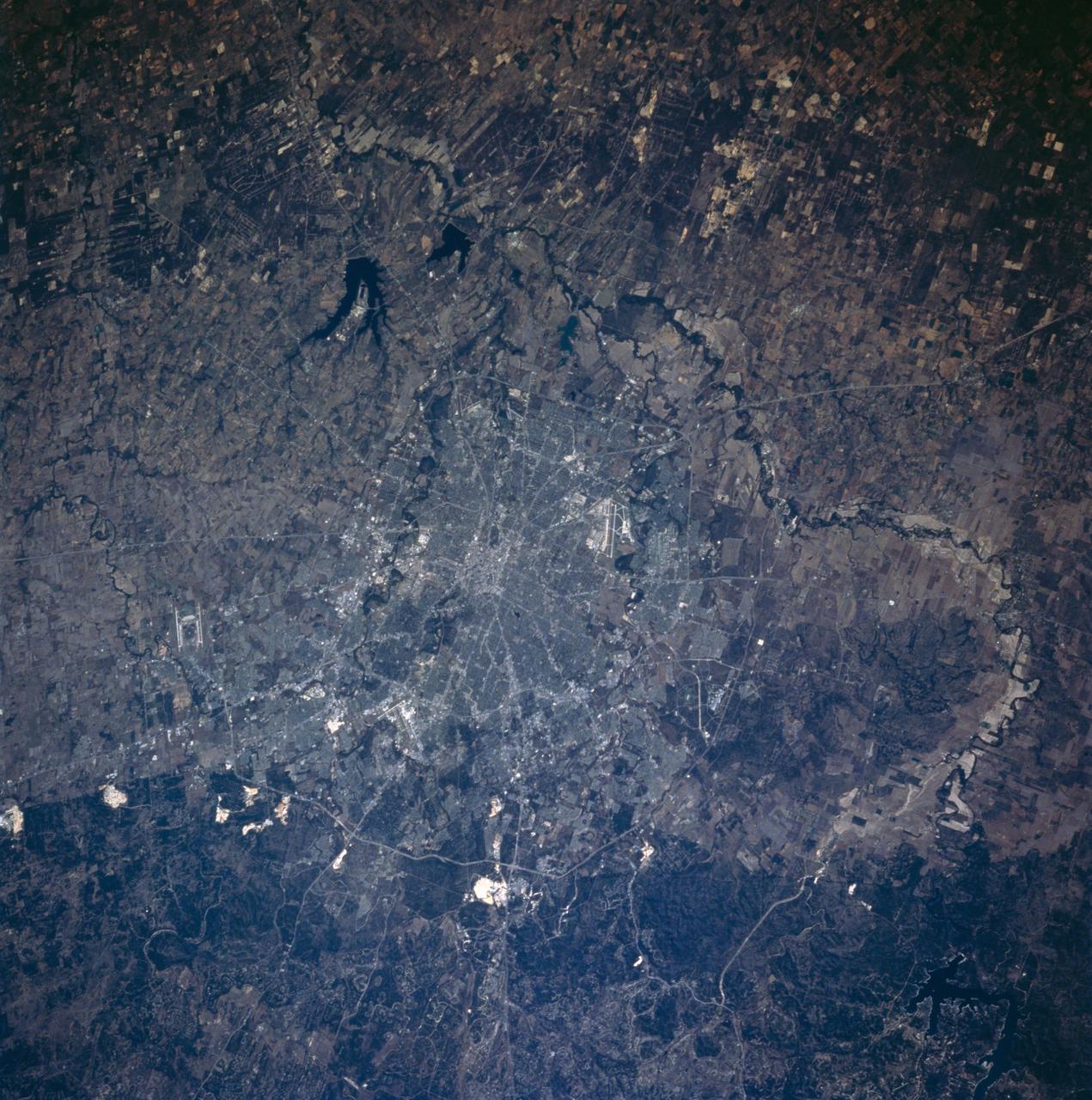
STS058-101-053 (18 Oct-1 Nov 1993) --- This sharp cloud-free photograph of San Antonio, Texas illustrates the classic pattern of western cities. The Hispanic heart of the city; an intertwining of streets along the San Antonio River and around the Alamo, surrounded by a late 19th century Anglo grid of small businesses and suburban homes. Transportation routes radiate to mid and late 20th Century ring corridors separating the urban/suburban region from the surrounding agricultural countryside. San Antonio was founded around permanent springs that rise at the foot of the Balcones Escarpment, which separates the Texas Hill Country from the South Texas Plains. Limestone quarries are conspicuous along the edge of the escarpment. San Antonio has long been a major site for military training bases: Randolph Air Force Base is outside the city to the northeast, Fort Sam Houston is contained within the northeast quadrant of the city, Brooks Air Force Base lies at the southeastern corner, and Lackland and Kelly Air Force Bases are within the suburban fringe to the southwest. San Antonio International Airport can be seen at the foot of the escarpment in the northern part of the city.
AS09-22-3441 (March 1969) --- Near vertical view of the Phoenix, Arizona area as photographed from the Apollo 9 spacecraft during its Earth-orbital mission. Farmland patterns checkerboard the area along the Gila River. Phoenix is located right of center near the clouds.
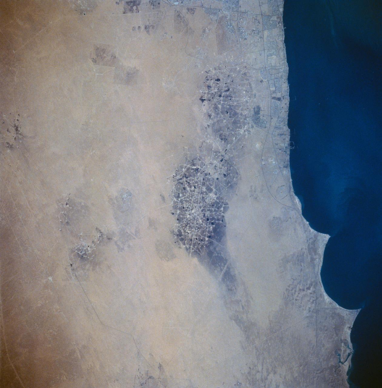
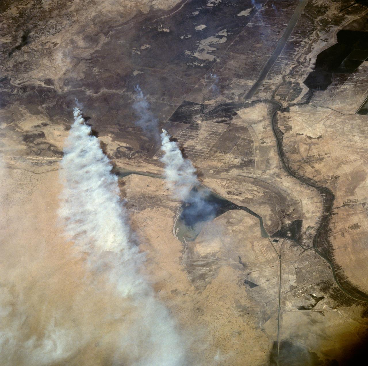
STS058-73-054 (18 Oct-1 Nov 1993) --- A clear view of the northern Kuwaiti coast shows the southern part of Kuwait City, and the major oil fields to the south. Oil-laden sands, where wells were set ablaze during the Gulf War in 1991, are visible south of Kuwait City as a dark, elongated patch surrounded by light-colored sand. Oil-stained sand between well sites (dots) and criss-crossing roads is gradually being covered by clean sand carried by strong, seasonal northwest winds.

AS09-20-3128 (3-13 March 1969) --- Cape Hatteras, North Carolina, area as photographed from the Apollo 9 spacecraft during its Earth-orbital mission. Cape Lookout is near bottom of picture. Cape Hatteras juts the farthest out into the Atlantic. Largest inland body of water is Pamlico Sound; and to the north of it is Albemarle Sound.
STS059-220-041 (9-20 April 1994) --- View to the south by southwest across the southern Gobi Desert (China) across the Chi-Lien-Shan or Quilienshan or Nanshan (Mountains) in Gansu Province to Lake Quinghai or Ch'ing-Hai (orthography varies with political conditions and scholarship) in Quinghai Province. The lake has a surface elevation of 10,450 feet, partially filling one of the easternmost closed drainage basins of Central Asia. Hasselblad photograph.
AS7-05-1667 (13 Oct. 1968) --- Kabul, Afghanistan area as seen from the Apollo 7 spacecraft during its 39th revolution of Earth. Photographed from an altitude of 127 nautical miles, at ground elapsed time of 61 hours and 20 minutes. Also, visible in picture are the Panjshir River and the Koh-i-Baba Mountains.
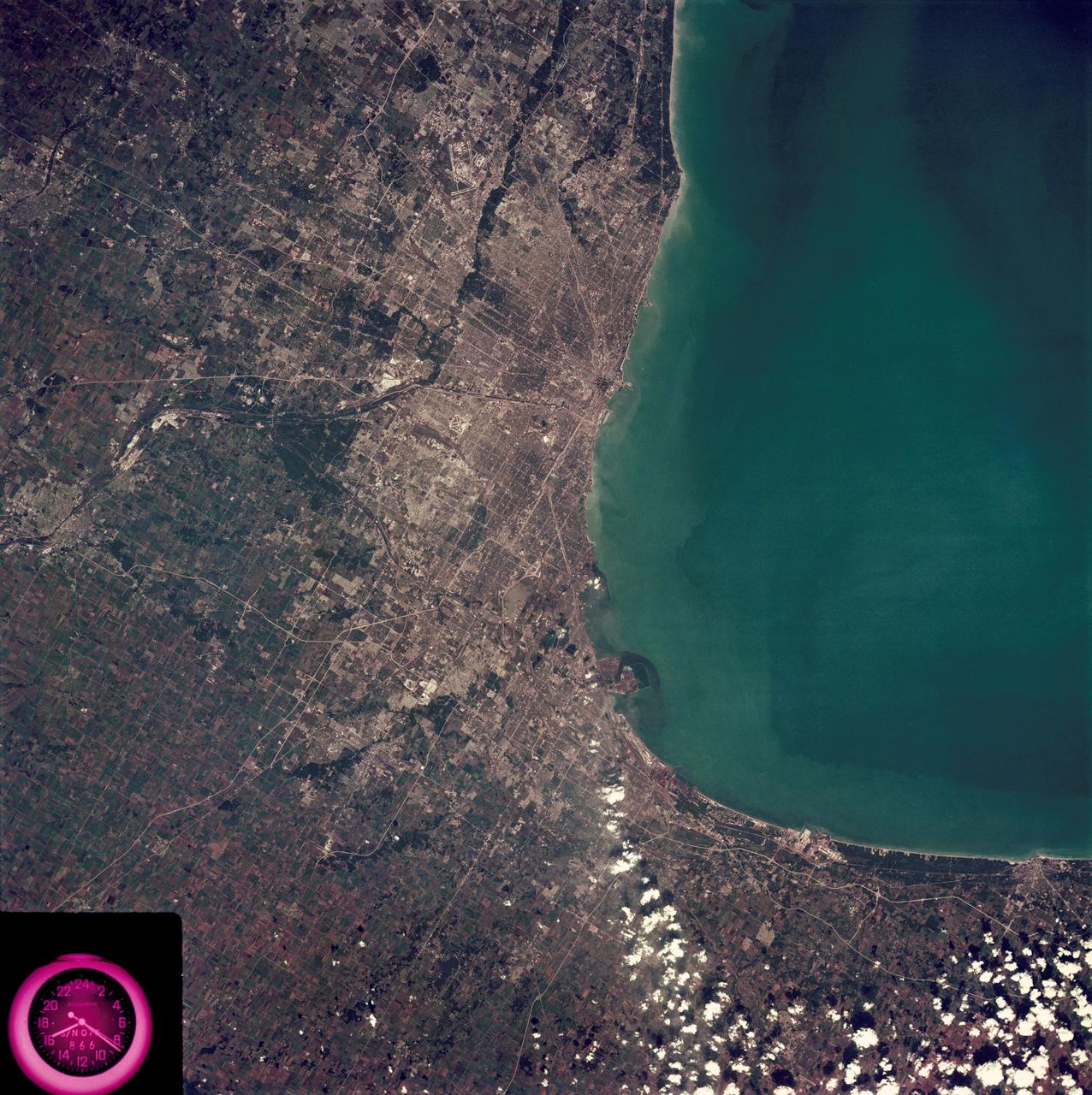
SL3-88-222 (18 Sept. 1973) --- The metropolitan area of Chicago is encompassed in this Skylab 3 Earth Resources Experiments Package (EREP) S190-B photograph taken on Sept. 18, 1973 from the Skylab space station cluster in Earth orbit. The surrounding major cities of Aurora and Joliet, Illinois; Hammond, Gary and East Chicago, Indiana, are easily delineated. The photograph reveals the following: (1) Cultural differentiation of commercial, industrial and residential areas for use in population and social studies in micro-macro community planning and in cultural pattern studies in the improvement of urban areas. (Aurora is one of 27 census cities of interest to Robert Alexander, a principal investigator. Alexander is with the U.S. Geological Survey). (2) The transportation network with major corridors and their interchanges, primary and feeder streets for use in network analysis and in the development of models for population movement and land use projection. (3) The agricultural lands for land use identification on crop inventory analysis; airports for use in delineation of service and infringement of major man-made features that affect ecosystem balance (support to environmental impact studies). (4) Air and water plumes for use in case studies, natural and man-made differentiation of pollution sources, in support of model development and in ecosystem research studies on the effects of pollution. (5) Recreational centers for use in relating recreational centers to population centers, establishing possible demands and in development of possible future recreational centers to support the demand. All EREP photography is available to the public through the Department of Interior?s Earth Resources Observations Systems Data Center, Sioux Falls, South Dakota, 57198. Photo credit: NASA
This view of southern California as seen from the Apollo 7 spacecraft during its 18th revolution of the earth. Photographed from an altitude of 124 nautical miles. The coast of California can be seen from Point Mugu southward to Oceanside. Santa Catalina can be seen below the off shore clouds. Details of the Los Angeles area are obscured by pollution which extends from Banning westard for 100 miles to beyond Malibu. In the upper portion of the photograph can be seen (left to right) the San Joaquin Valley beyond Bakersfield, the Techachapi Mountains, the Sierra Nevada, Owens Valley, Death Valley and the Mojave Desert.
Lake Nasser on the Nile River in southeastern United Arab Republic (Egypt) as seen from the Apollo 7 spacecraft during its 10th revolution of the earth. Photographed from an altitude of 130 nautical miles, at ground elapsed time of 14 hours and 56 minutes. Lake Nasser was created by the contruction of the Aswan Dam on the Nile.
SL4-141-4340 (20 Jan. 1974) --- An oblique view of the southern part of the Sea of Okhotsk, north of Japan, as photographed from the Skylab space station in Earth orbit by one of the Skylab 4 crewmen. The camera used was a hand-held 70mm Hasselblad, and SO-368 medium-speed Ektachrome. NORTH IS AT THE TOP WHEN THE PICTURE IS HELD WITH THE LARGEST LAND MASS AT THE BOTTOM. Most of the land area is Hokkaido Island, Japan. The southern tip of Sakhalin Island (Soviet Union) is in the northwest corner. This photograph was taken to aid in the study of the formation of sea ice. Comparison of these photographs will be made with observations made during a joint USSR-U.S. experiment in the Bering Sea a year earlier. Observations in the Sea of Okhotsk are of interest because the ice has a morphology similar to that of the Bering Sea. Photo credit: NASA
AS09-23-3561 (3-13 March 1969) --- Near vertical view of the Lubbock area in west Texas as photographed from the Apollo 9 spacecraft during its Earth-orbital mission. Conspicuous patterns of farmland surround the city and extend eastward (up) to the Caprock Escarpment. The Double Mountain fork of the Brazos River drains east (toward upper center); Leeland is at lower center; Brownfield at lower right. The sharp edge of a cloud disk cuts across the upper right corner.
S66-54692 (14 Sept. 1966) --- Indonesian Islands (partial cloud cover): Sumatra, Java, Bali, Borneo, and Sumbawa, as photographed from the Gemini-11 spacecraft during its 26th revolution of Earth, at an altitude of 570 nautical miles. Photo credit: NASA
AS07-04-1609 (21 Oct. 1968) --- Woodlark Island in the Solomon Sea, east of New Guinea and northeast of Australia, as seen from the Apollo 7 spacecraft during its 158th revolution of Earth. Photographed from an altitude of 140 nautical miles, at ground elapsed time of 251 hours and 21 minutes.

AS07-05-1652 (13 Oct. 1968) --- Pacific coast area of southwestern Mexico, State of Guerrero, from Acapulco to Tecoanapa, as seen from the Apollo 7 spacecraft during its 34th revolution of Earth. Photographed from an altitude of 125 nautical miles, at ground elapsed time of 54 hours and 10 minutes. Much cloud cover in area.
STS058-101-014 (18 Oct-1 Nov 1993) --- The best, most-nearly cloud-free, shuttle view yet of Mount Everest, the highest mountain in the world at 29,028 feet. The peak, on the border between Nepal and China, is almost exactly in the center of the photograph. The challenging North Face is in shadow; valley glaciers radiate in all directions from the central massif.
STS064-83-099 (9-20 Sept. 1994) --- Multiple thunderstorm cells leading to Earth's atmosphere were photographed on 70mm by the astronauts, orbiting aboard the space shuttle Discovery 130 nautical miles away. These thunderstorms are located about 16 degrees southeast of Hawaii in the Pacific Ocean. Every stage of a developing thunderstorm is documented in this photo; from the building cauliflower tops to the mature anvil phase. The anvil or the tops of the clouds being blown off are at about 50,000 feet. The light line in the blue atmosphere is either clouds in the distance or an atmospheric layer which is defined but different particle sizes. Photo credit: NASA or National Aeronautics and Space Administration
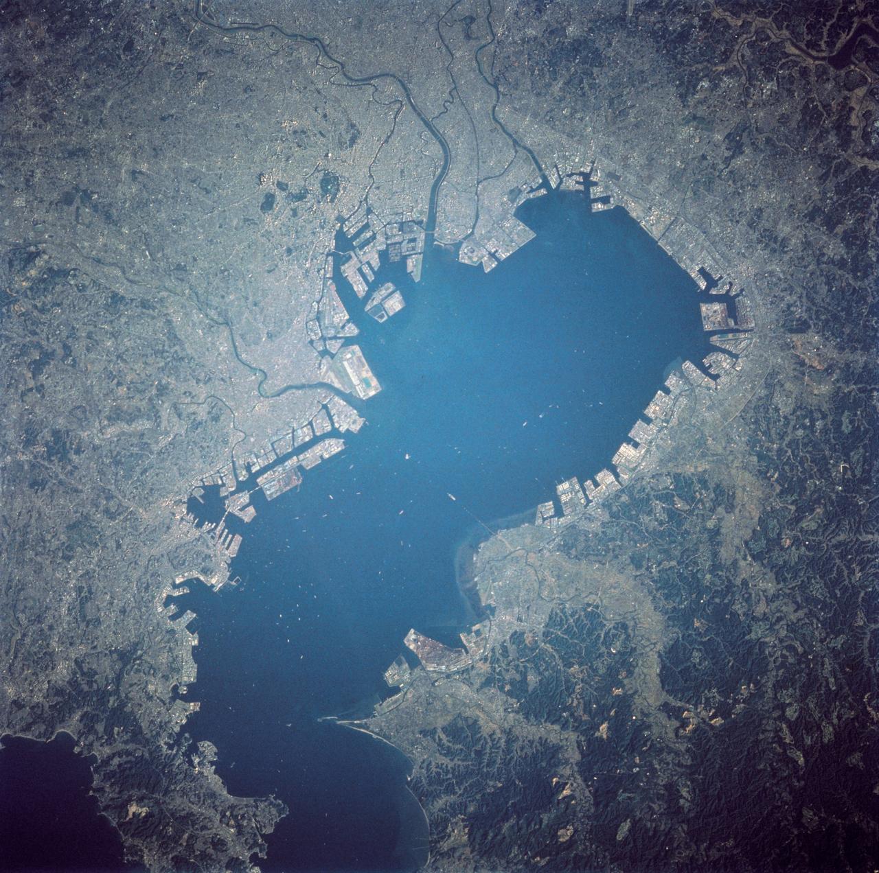
STS058-103-080 (18 Oct-1 Nov 1993) --- Japan's modern megalopolis is seen in this nadir view in great detail. More than 80 vessels can be seen at the anchorage's in Tokyo Bay. The gardens of the Emperor's Palace are seen in this circular area in the upper left quadrant. Even greater detail of this area was captured in the simultaneous color infrared image acquired during this space shuttle mission. (That photo number is STS058-110-085.)
AS07-07-1872 (11-22 Oct. 1968) --- The Houston, Texas, and Gulf Coast area, looking southeast, as seen from the Apollo 7 spacecraft at an altitude of 101 nautical miles. This photograph was made during the spacecraft's 91st revolution of Earth, at ground elapsed time of 144 hours and 26 minutes. The morning sun causes a spectacular reflection on water surfaces such as the Gulf of Mexico, Galveston Bay, Buffalo Bayou, and the Brazos River, and causes a unique reflection in the canals and rice fields west of Alvin. Some of the landmarks visible in this picture include highways and freeways, the Astrodome, the new Intercontinental Airport, and the Manned Spacecraft Center.
AS08-16-2588 (21-27 Dec. 1968) --- Both sides of the Atlantic Ocean are visible in this view from Apollo 8 spacecraft. (Hold picture with Earth at bottom left). The large, most prominent land mass is the bulge of West Africa. The portion of Africa near the equator is dark and cloudy, but the more northerly portions are clear, showing the prominent cape at Dakar and the Senegal River in Senegal; Cap Blanc; the Adrar Plateau in Mauretania; the wide expanse of desert in Algeria and Spanish Sahara; and the far edge, the Atlas and Anti-Atlas Mountains in Morocco. Clouds cover the eastern coast of South America, southward from Surinam and Guyana to near the city of Salvador, Brazil. The view was photographed following trans-lunar insertion.
AS09-23-3586 (11 March 1969) --- Dallas, Ft. Worth, Sherman, Denison, Red River, and Lake Texoma, as photographed from the Apollo 9 spacecraft during its 122nd revolution of Earth.
STS059-154-160 (9-20 April 1994) --- Orient with Mono Lake, California at the lower right; then the view is westward across the Sierra Nevada into the San Joaquin River drainage. A tiny network of ski trails can be seen on the Mono Lake side of the Sierras, on a line between Mono Lake and the snow-free San Joaquin headwaters. The ski trails mark Mammoth Mountain, where SRL investigators are studying microwave measurements of the water content of snowpacks. Linhof camera.
AS7-07-1748 (15 Oct. 1968) --- The world's dozen peaks which reach a height of greater than five miles above sea level are seen in this photograph from the Apollo 7 spacecraft at an altitude of approximately 130 nautical miles. The 29,028 ft. high Mount Everest is at lower center. On the central horizon can be seen the 28,250 ft. high Mount Godwin-Austen (K-2) some 800 miles northwest of Mount Everest. In the lower right, Mount Kanchenjunga rises 28,208 ft. to separate Nepal from Sikkim. The snow line on the peaks was at 17,500 ft. In the upper right the lake-studded highlands of Tibet are visible.
STS059-81-095 (9-20 April 1994) --- View southwestward across the Kamchatka Peninsula. The cluster of volcanoes in the middle distance are active, including Klutchevskaya whose summit reaches 15,580 feet. Changes in volcanic deposits, snow, and ice are being studied by Russian and American SRL investigators. Seasonal changes in sea ice are also of interest, for example, in Kamchatskiy Bay (upper left). Hasselblad camera, 40mm lens.
SL4-142-4542 (November 1973-February 1974) --- An oblique view of the Pacific Coast of Southern California, including the Los Angeles and San Diego areas, as seen from the Skylab space station in Earth orbit. This picture was taken by one of the Skylab 4 crewmen using a hand-held 70mm Hasselblad camera with a 100mm lens and SO-368 medium-speed Ektachrome film. The visible coastline extends from San Diego northwesterly to Santa Barbara. The Mojave Desert occupies much of the photograph. This view also includes the Channel Islands off the coast. Note that the higher elevations of the mountains are covered with snow. Photo credit: NASA
STS059-82-010 (9-20 April 1994) --- View northwestward of a small part of southeastern Iraq. The city of Basra can be seen in the lower left corner, and the former junction of the Tigris and Euphrates Rivers in the upper right. The streams have been channelized, in part to dewater and burn an extensive marsh. Hasselblad camera, 250mm lens.
STS058-100-073 (18 Oct-1 Nov 1993) --- An unusually clear, northwestward view of central North Carolina shows the farms and timber of the inner coastal plain. The city of Fayetteville, and Fort Bragg to the west, is prominent at lower left center. The Research Triangle of Raleigh, Durham and Chapel Hill can be seen at upper right, upstream from Jordan Lake and Harris Lake on the New Hope River.
AS09-22-3463 (9 March 1969) --- Oblique view of the Houston, Texas area as photographed from the Apollo 9 spacecraft during its Earth-orbital mission. This picture was taken from an altitude of 103 nautical miles, at about 1:40 p.m. (CST), on March 9, 1969. Prominent features visible include highways leading out of the city, Lake Houston, San Jacinto River, Trinity Bay, Galveston Bay, Brazos River, Baytown, and Texas City.
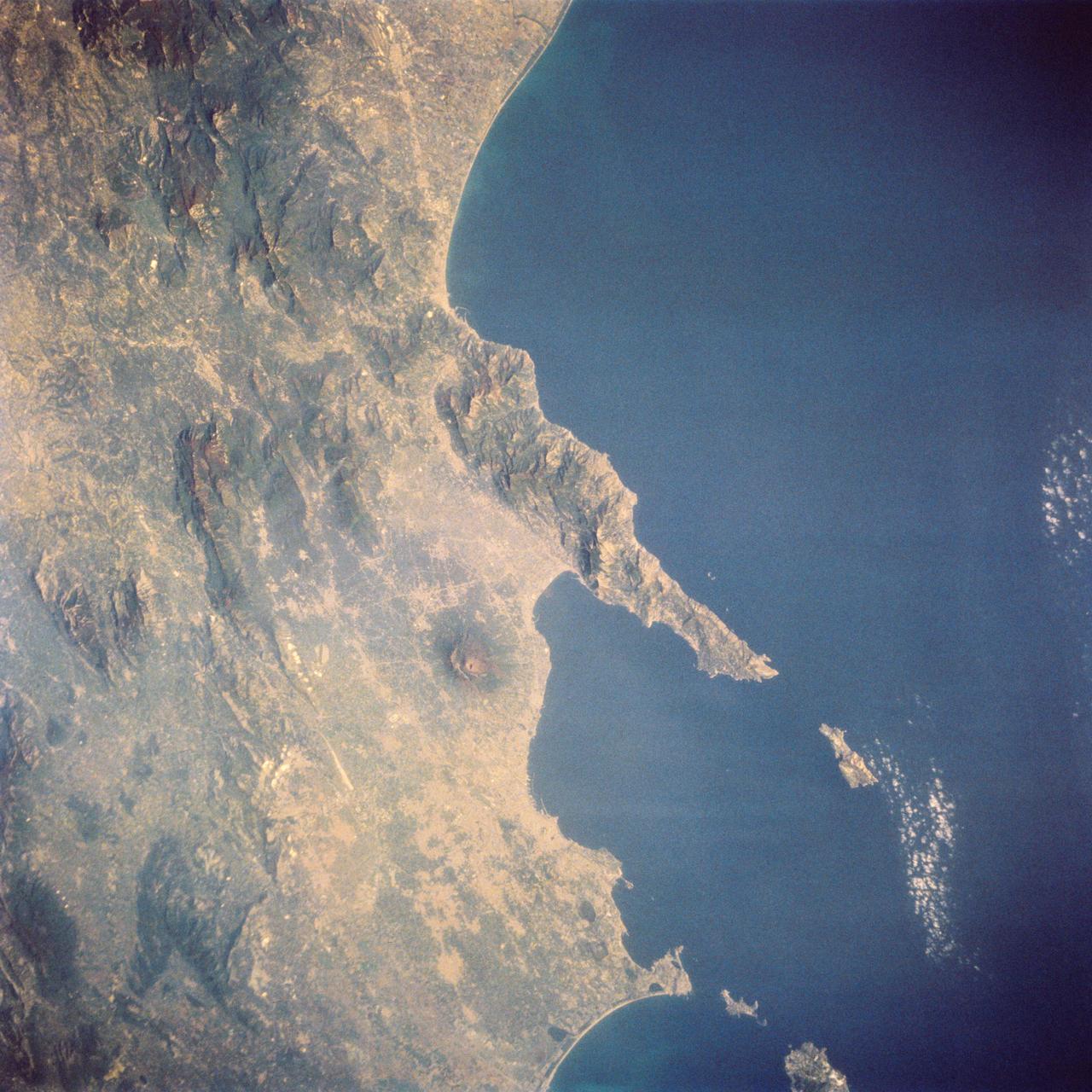
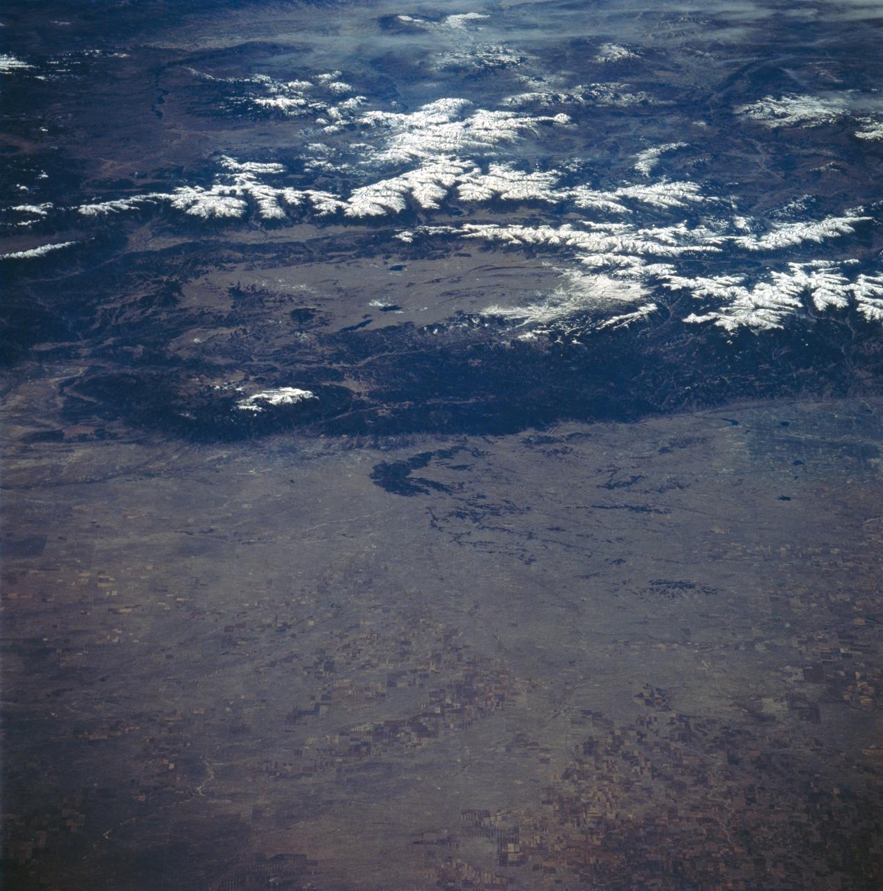
STS058-73-024 (18 Oct-1 Nov 1993) --- The ancient eruption of Vesuvius (the volcano near the center of the frame) destroyed the town of Pompeii located on its southeast flank. But the larger town of Naples, between Vesuvius (to the south) and the large, circular, lake-filled caldera of Campi Flegrei (to the west) also lives with the constant threat of volcanic hazards. In this view, Naples is the gray urban area with substantial coastal development just northwest of Vesuvius. Other landmarks marking the Italian coast include the small island of Capri, just off the west-pointing peninsula, and the city of Salerno on the coast just south of the same peninsula.