
This cross section of the Earth's atmosphere at sunset and earth limb (24.5S, 43.5E) displays an unusual layering believed to be caused by temperature inversions which effectively concentrate smoke, dust and aerosols into narrow layers. the top of the stratosphere can be seen as the top of the white layer thought to contain volcanic debris. The purple layer is the troposphere containing smoke from landclearing biomass burning.
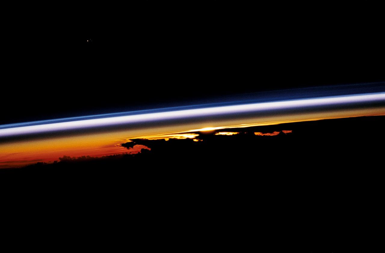
STS047-54-018 (12-20 Sept. 1992) --- The colors in this photograph provide insight into the relative density of the atmosphere. The crew members had many opportunities to witness sunrises and sunsets, considering they orbit the Earth every 90 minutes, but few, they said, compared to this scene. It captures the silhouette of several mature thunderstorms with their cirrus anvil tops spreading out against the tropopause (the top of the lowest layer of Earth's atmosphere) at sunset. The lowest layer (troposphere) is the densest and refracts light at the red end of the visible spectrum (7,400 Angstroms), while the blues (4,000 Angstroms) are separated in the least dense portion of the atmosphere (middle and upper atmosphere, or stratosphere and mesosphere). Several layers of blue can be seen. NASA scientists studying the photos believe this stratification to be caused by the scattering of light by particulate trapped in the stratosphere and mesosphere particulate that generally originate from volcanic eruptions, such as those of Mt. Pinatubo in the Philippines and, most recently, Mt. Spurr in Alaska.
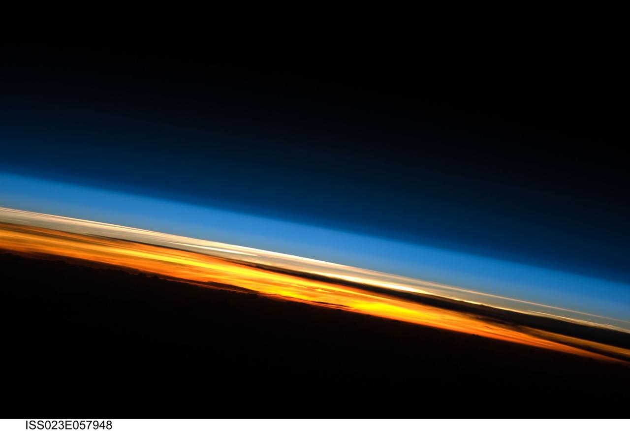
ISS023-E-057948 (25 May 2010) --- A sunset on the Indian Ocean is featured in this image photographed by an Expedition 23 crew member on the International Space Station (ISS). The image presents an edge-on, or limb view, of Earth’s atmosphere as seen from orbit. The Earth’s curvature is visible along the horizon line, or limb, that extends across the image from center left to lower right. Above the darkened surface of Earth, a brilliant sequence of colors roughly denotes several layers of the atmosphere. Deep oranges and yellows are visible in the troposphere that extends from Earth’s surface to 6-20 kilometers high. This layer contains over 80 percent of the mass of the atmosphere and almost all of the water vapor, clouds, and precipitation – several dark cloud layers are visible within this layer. Variations in the colors are due mainly to varying concentrations of either clouds or aerosols (airborne particles or droplets). The pink to white region above the clouds appears to be the stratosphere; this atmospheric layer generally has little or no clouds and extends up to approximately 50 kilometers above Earth’s surface. Above the stratosphere blue layers mark the upper atmosphere (including the mesosphere, thermosphere, ionosphere, and exosphere) as it gradually fades into the blackness of outer space. The ISS was located over the southern Indian Ocean when this image was taken, with the observer looking towards the west. Crew members aboard the space station see 16 sunrises and sunsets per day due to their high orbital velocity (greater than 28,000 kilometers per hour). The multiple chances for photography are fortunate, as at that speed each sunrise/sunset event only lasts a few seconds.
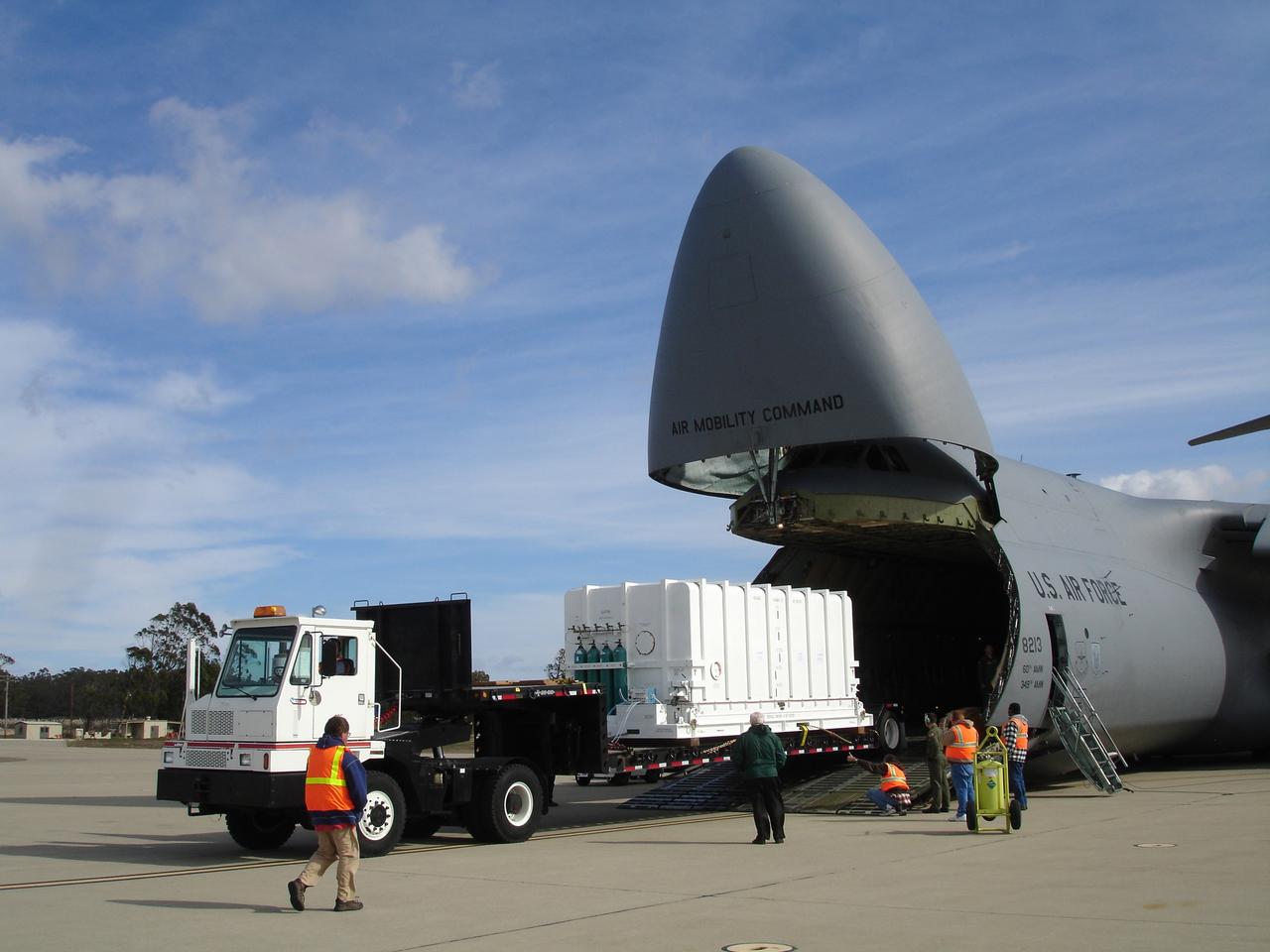
VANDENBERG AIR FORCE BASE, Calif. – The NOAA-N Prime spacecraft is offloaded from a C-5 aircraft after arrival at Vandenberg Air Force Base Airfield in California. NOAA-N Prime was built by Lockheed Martin Space Systems Company for its Advanced Television Infrared Observational Satellites -N series. It is the latest polar-orbiting operational environmental weather satellite developed by NASA for the National Oceanic and Atmospheric Administration. The satellite will provide a platform to support environmental monitoring instruments for imaging and measuring the Earth's atmosphere, its surface and cloud cover, including Earth radiation, atmospheric ozone, aerosol distribution, sea surface temperature and vertical temperature and water profiles in the troposphere and stratosphere. The satellite will assist in measuring proton and electron fluxes at orbit altitude, collecting data from remote platforms to assist the Search and Rescue Satellite-Aided Tracking system. The satellite will be launched from the Western Range at Vandenberg AFB by a United Launch Alliance two-stage Delta II rocket managed by NASA's Launch Service Program at Kennedy. Photo credit: NASA/Jerry Nagy, VAFB

VANDENBERG AIR FORCE BASE, Calif. – The NOAA-N Prime spacecraft is offloaded from the transporter at NASA's Hazardous Processing Facility on Vandenberg Air Force Base in California. NOAA-N Prime was built by Lockheed Martin Space Systems Company for its Advanced Television Infrared Observational Satellites -N series. It is the latest polar-orbiting operational environmental weather satellite developed by NASA for the National Oceanic and Atmospheric Administration. The satellite will provide a platform to support environmental monitoring instruments for imaging and measuring the Earth's atmosphere, its surface and cloud cover, including Earth radiation, atmospheric ozone, aerosol distribution, sea surface temperature and vertical temperature and water profiles in the troposphere and stratosphere. The satellite will assist in measuring proton and electron fluxes at orbit altitude, collecting data from remote platforms to assist the Search and Rescue Satellite-Aided Tracking system. The satellite will be launched from the Western Range at Vandenberg AFB by a United Launch Alliance two-stage Delta II rocket managed by NASA's Launch Service Program at Kennedy. Photo credit: NASA/Jerry Nagy, VAFB
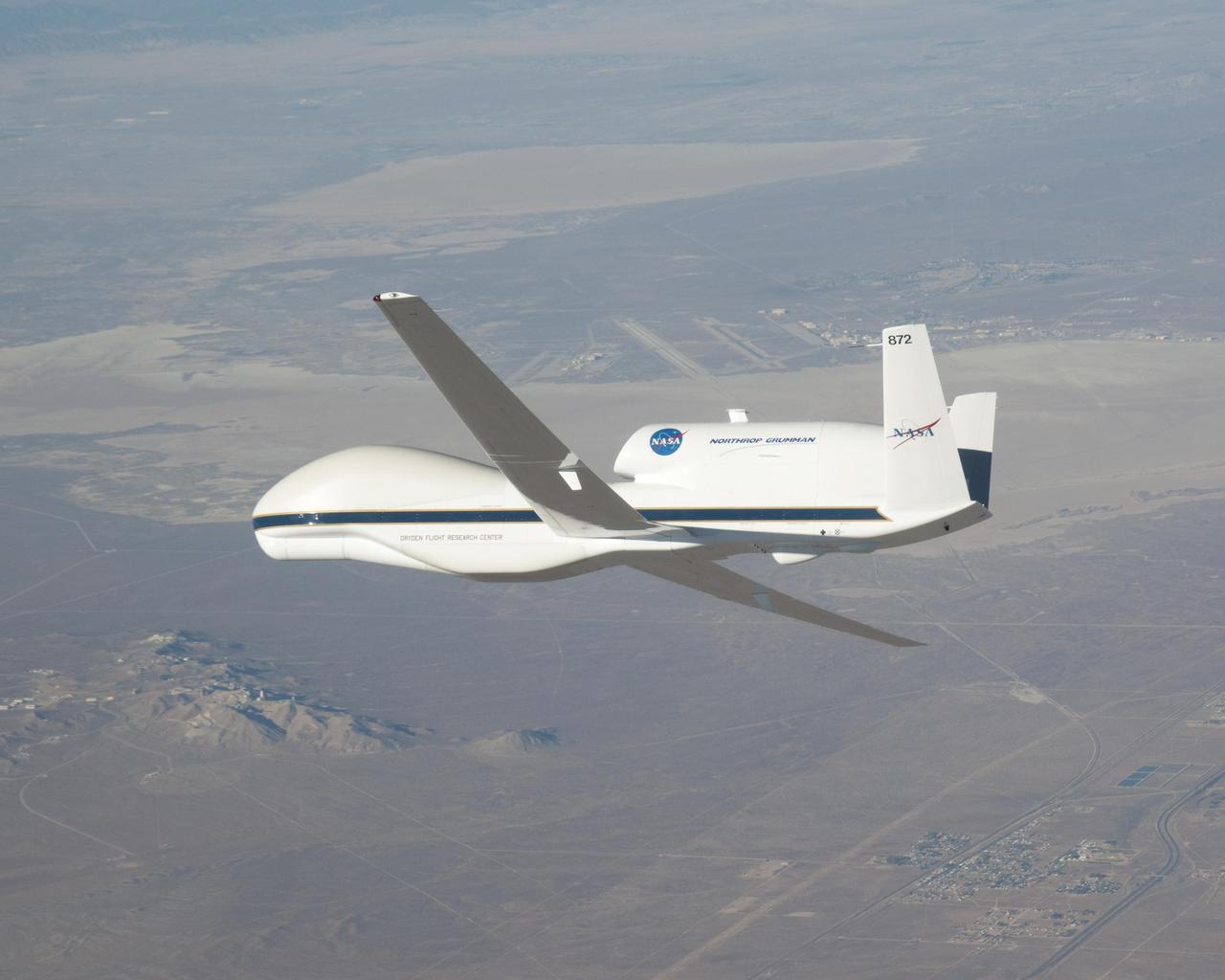
NASA image acquired October 23, 2009. At NASA’s Dryden Research Center in California, a group of engineers, scientists, and aviation technicians have set up camp in a noisy, chilly hangar on Edwards Air Force base. For the past two weeks, they have been working to mount equipment—from HD video cameras to ozone sensors—onto NASA’s Global Hawk, a remote-controlled airplane that can fly for up to 30 hours at altitudes up to 65,000 feet. The team is gearing up for the Global Hawk Pacific campaign, a series of four or five scientific research flights that will take the Global Hawk over the Pacific Ocean and Arctic regions. The 44-foot-long aircraft, with its comically large nose and 116-foot wingspan is pictured in the photograph above, banking for landing over Rogers Dry Lake in California at the end of a test flight on October 23, 2009. The long wings carry the plane’s fuel, and the bulbous nose is one of the payload bays, which house the science instruments. For the Global Hawk Pacific campaign, the robotic aircraft will carry ten science instruments that will sample the chemical composition of air in the troposphere (the atmospheric layer closest to Earth) and the stratosphere (the layer above the troposphere). The mission will also observe clouds and aerosol particles in the troposphere. The primary purpose of the mission is to collect observations that can be used to check the accuracy of simultaneous observations collected by NASA’s Aura satellite. Co-lead scientist Paul Newman from Goddard Space Flight Center is writing about the ground-breaking mission for the Earth Observatory’s Notes from the Field blog. NASA Photograph by Carla Thomas. <b><a href="http://www.nasa.gov/centers/goddard/home/index.html" rel="nofollow">NASA Goddard Space Flight Center</a></b> is home to the nation's largest organization of combined scientists, engineers and technologists that build spacecraft, instruments and new technology to study the Earth, the sun, our solar system, and the universe. To learn more about this image go to: <a href="http://earthobservatory.nasa.gov/IOTD/view.php?id=43291" rel="nofollow">earthobservatory.nasa.gov/IOTD/view.php?id=43291</a>

VANDENBERG AIR FORCE BASE, Calif. – The NOAA-N Prime spacecraft is positioned for movement into NASA's Hazardous Processing Facility on Vandenberg Air Force Base in California. NOAA-N Prime was built by Lockheed Martin Space Systems Company for its Advanced Television Infrared Observational Satellites -N series. It is the latest polar-orbiting operational environmental weather satellite developed by NASA for the National Oceanic and Atmospheric Administration. The satellite will provide a platform to support environmental monitoring instruments for imaging and measuring the Earth's atmosphere, its surface and cloud cover, including Earth radiation, atmospheric ozone, aerosol distribution, sea surface temperature and vertical temperature and water profiles in the troposphere and stratosphere. The satellite will assist in measuring proton and electron fluxes at orbit altitude, collecting data from remote platforms to assist the Search and Rescue Satellite-Aided Tracking system. The satellite will be launched from the Western Range at Vandenberg AFB by a United Launch Alliance two-stage Delta II rocket managed by NASA's Launch Service Program at Kennedy. Photo credit: NASA/Jerry Nagy, VAFB

VANDENBERG AIR FORCE BASE, Calif. – Workers move the NOAA-N Prime spacecraft into NASA's Hazardous Processing Facility on Vandenberg Air Force Base in California. NOAA-N Prime was built by Lockheed Martin Space Systems Company for its Advanced Television Infrared Observational Satellites -N series. It is the latest polar-orbiting operational environmental weather satellite developed by NASA for the National Oceanic and Atmospheric Administration. The satellite will provide a platform to support environmental monitoring instruments for imaging and measuring the Earth's atmosphere, its surface and cloud cover, including Earth radiation, atmospheric ozone, aerosol distribution, sea surface temperature and vertical temperature and water profiles in the troposphere and stratosphere. The satellite will assist in measuring proton and electron fluxes at orbit altitude, collecting data from remote platforms to assist the Search and Rescue Satellite-Aided Tracking system. The satellite will be launched from the Western Range at Vandenberg AFB by a United Launch Alliance two-stage Delta II rocket managed by NASA's Launch Service Program at Kennedy. Photo credit: NASA/Jerry Nagy, VAFB
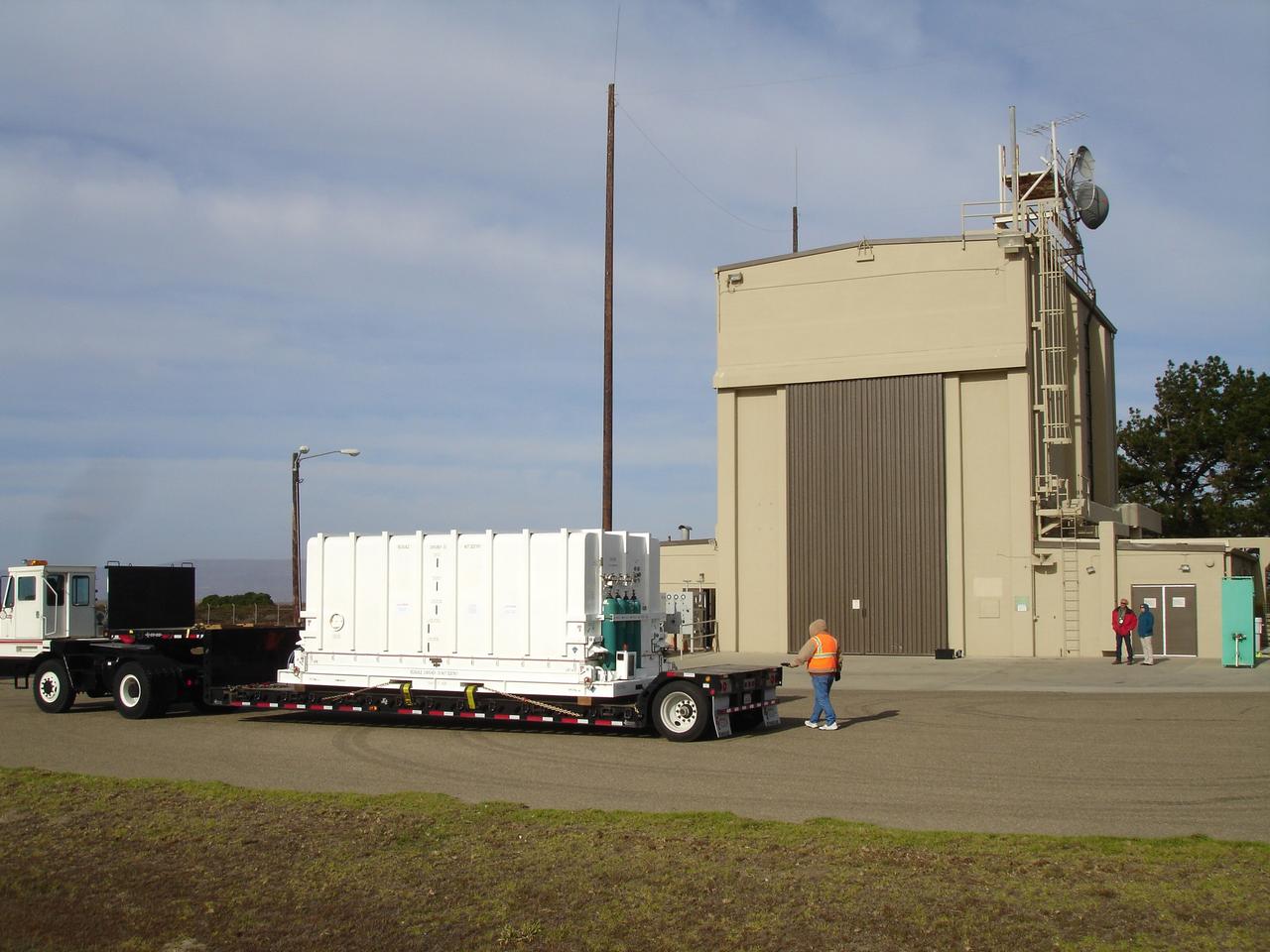
VANDENBERG AIR FORCE BASE, Calif. – The NOAA-N Prime spacecraft arrives at NASA's Hazardous Processing Facility on Vandenberg Air Force Base in California. NOAA-N Prime was built by Lockheed Martin Space Systems Company for its Advanced Television Infrared Observational Satellites -N series. It is the latest polar-orbiting operational environmental weather satellite developed by NASA for the National Oceanic and Atmospheric Administration. The satellite will provide a platform to support environmental monitoring instruments for imaging and measuring the Earth's atmosphere, its surface and cloud cover, including Earth radiation, atmospheric ozone, aerosol distribution, sea surface temperature and vertical temperature and water profiles in the troposphere and stratosphere. The satellite will assist in measuring proton and electron fluxes at orbit altitude, collecting data from remote platforms to assist the Search and Rescue Satellite-Aided Tracking system. The satellite will be launched from the Western Range at Vandenberg AFB by a United Launch Alliance two-stage Delta II rocket managed by NASA's Launch Service Program at Kennedy. Photo credit: NASA/Jerry Nagy, VAFB
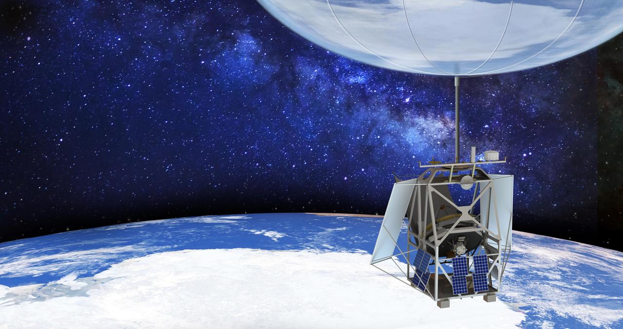
NASA's Astrophysics Stratospheric Telescope for High Spectral Resolution Observations at Submillimeter-wavelengths (ASTHROS), seen in this illustration, is a high-altitude balloon mission for studying astrophysical phenomena. Scheduled to launch no earlier than December 2023 from the agency's Long Duration Balloon Camp near McMurdo Station in Antarctica, ASTHROS will aim to fly for 21 to 28 days at an altitude of about 130,000 feet (24.6 miles or 40 kilometers). At that altitude, ASTHROS can observe wavelengths of light blocked by Earth's atmosphere. When fully inflated, the 40 million-cubic-foot helium balloon will be about 400 feet (150 meters) wide, or roughly the size of a football stadium. The ASTHROS telescope features a lightweight 8.4-foot (2.5-meter) primary mirror to collect far-infrared light – one of the largest to ever fly on a high-altitude balloon mission. Balloon missions typically cost less than space missions and take less time to move from early planning to deployment. They also employ new technologies that can then be used on future space missions. The mission's main science goal is to study stellar feedback, the process by which living stars disperse and reshape clouds of gas and dust that may eventually form new stars. Feedback regulates star formation in many galaxies, and too much can halt star formation entirely. ASTHROS will look at several star-forming regions in our galaxy where feedback takes place, and at distant galaxies containing millions of stars to see how feedback plays out at large scales and in different environments. https://photojournal.jpl.nasa.gov/catalog/PIA25168
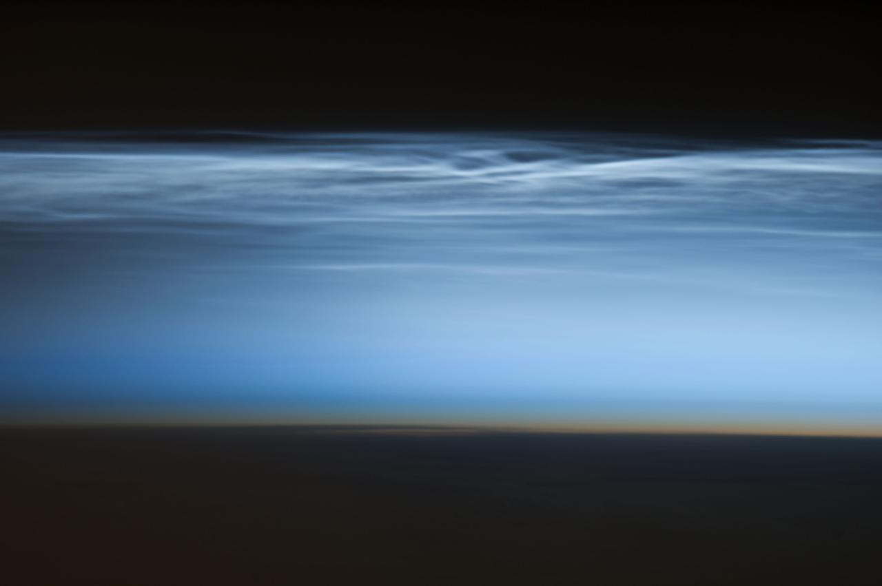
ISS034-E-024622 (5 Jan. 2013) --- Polar mesospheric clouds over the South Pacific Ocean are featured in this image photographed by an Expedition 34 crew member on the International Space Station. Polar mesospheric clouds—also known as noctilucent, or “night shining” clouds—are formed 76 to 85 kilometers above Earth’s surface near the mesosphere-thermosphere boundary of the atmosphere, a region known as the mesopause. At these altitudes, water vapor can freeze into clouds of ice crystals. When the sun is below the horizon such that the ground is in darkness, these high clouds may still be illuminated—lending them their ethereal, “night shining” qualities. Noctilucent clouds have been observed from all human vantage points in both the Northern and Southern Hemispheres – from the surface, in aircraft, and in orbit from the space station—and tend to be most visible during the late spring and early summer seasons. Polar mesospheric clouds also are of interest to scientists studying the atmosphere. While some scientists seek to understand their mechanisms of formation, others have identified them as potential indicators of atmospheric changes resulting from increases in greenhouse gas concentrations. This photograph was taken when the station was over the Pacific Ocean south of French Polynesia. While most polar mesospheric cloud images are taken from the orbital complex with relatively short focal length lens to maximize the field of view, this image was taken with a long lens (400 mm) allowing for additional detail of the cloud forms to be seen. Below the brightly-lit noctilucent clouds in the center of the image, the pale orange band indicates the stratosphere.

This is a Hubble Space Telescope composite image of a supernova explosion designated SN 2014J in the galaxy M82. At a distance of approximately 11.5 million light-years from Earth it is the closest supernova of its type discovered in the past few decades. The explosion is categorized as a Type Ia supernova, which is theorized to be triggered in binary systems consisting of a white dwarf and another star — which could be a second white dwarf, a star like our sun, or a giant star. Astronomers using a ground-based telescope discovered the explosion on January 21, 2014. This Hubble photograph was taken on January 31, as the supernova approached its peak brightness. The Hubble data are expected to help astronomers refine distance measurements to Type Ia supernovae. In addition, the observations could yield insights into what kind of stars were involved in the explosion. Hubble’s ultraviolet-light sensitivity will allow astronomers to probe the environment around the site of the supernova explosion and in the interstellar medium of the host galaxy. Because of their consistent peak brightness, Type Ia supernovae are among the best tools to measure distances in the universe. They were fundamental to the 1998 discovery of the mysterious acceleration of the expanding universe. A hypothesized repulsive force, called dark energy, is thought to cause the acceleration. Among the other major NASA space-based observatories used in the M82 viewing campaign are Spitzer Space Telescope, Chandra X-ray Observatory, Nuclear Spectroscopic Telescope Array (NuSTAR), Fermi Gamma-ray Space Telescope, Swift Gamma Ray Burst Explorer, and the Stratospheric Observatory for Infrared Astronomy (SOFIA). Image Credit: NASA, ESA, A. Goobar (Stockholm University), and the Hubble Heritage Team (STScI/AURA) <b><a href="http://www.nasa.gov/audience/formedia/features/MP_Photo_Guidelines.html" rel="nofollow">NASA image use policy.</a></b> <b><a href="http://www.nasa.gov/centers/goddard/home/index.html" rel="nofollow">NASA Goddard Space Flight Center</a></b> enables NASA’s mission through four scientific endeavors: Earth Science, Heliophysics, Solar System Exploration, and Astrophysics. Goddard plays a leading role in NASA’s accomplishments by contributing compelling scientific knowledge to advance the Agency’s mission. <b>Follow us on <a href="http://twitter.com/NASAGoddardPix" rel="nofollow">Twitter</a></b> <b>Like us on <a href="http://www.facebook.com/pages/Greenbelt-MD/NASA-Goddard/395013845897?ref=tsd" rel="nofollow">Facebook</a></b> <b>Find us on <a href="http://instagram.com/nasagoddard?vm=grid" rel="nofollow">Instagram</a></b>