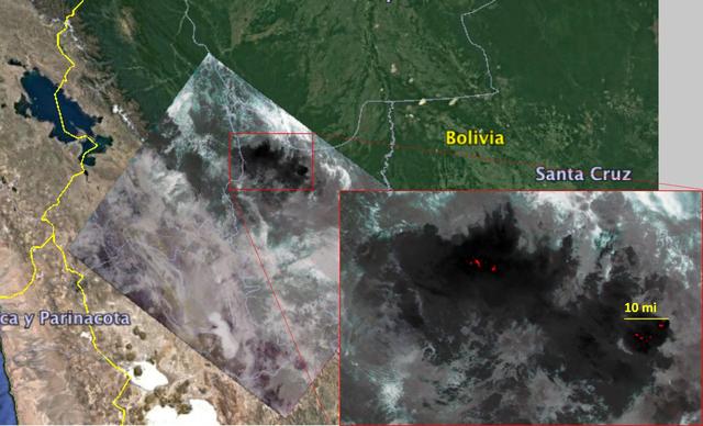
NASA's Ecosystem Spaceborne Thermal Radiometer Experiment on Space Station (ECOSTRESS) captured new imagery of fires in the Amazon regions of Brazil and Bolivia on Aug. 23, 2019. The red areas are where surface temperatures exceeded the maximum measureable temperature of the instrument's sensor (approximately 220 degrees Fahrenheit or 104 degrees Celsius), highlighting the burning areas along the fire fronts. The dark wispy areas indicate thick smoke — thick enough that it obscures much of the fire from view. The measurements cover areas of about 77 by 77 yards (70 by 70 meters) each, or about the size of a football field. https://photojournal.jpl.nasa.gov/catalog/PIA23357
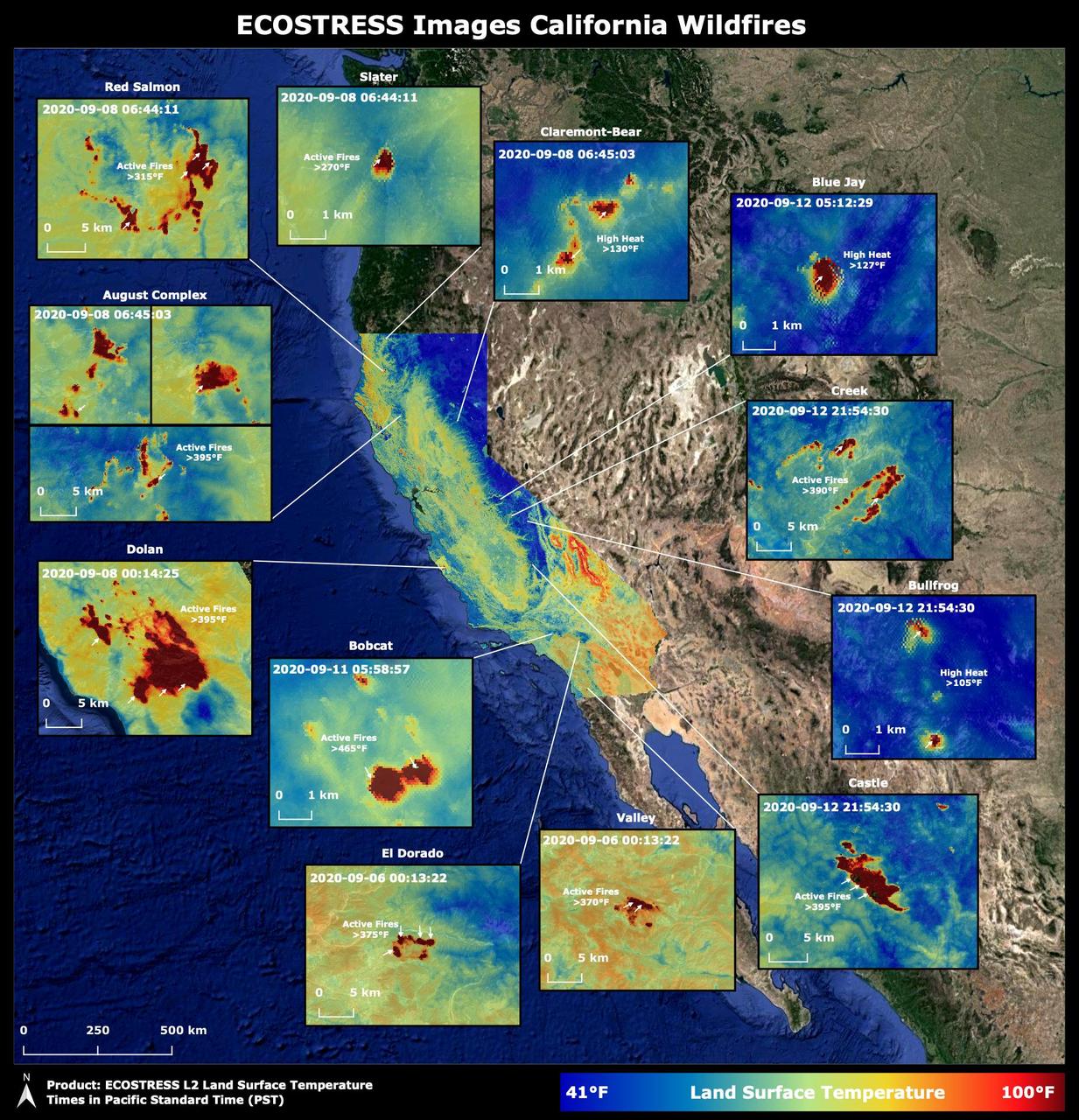
Throughout the month of September 2020, NASA's ECOsystem Spaceborne Thermal Radiometer Experiment on Space Station (ECOSTRESS) imaged multiple wildfires across the state of California. The image above shows the ECOSTRESS land surface temperature of California. Multiple insets highlight a fraction of the multiple fires that have impacted California, with effects seen throughout the U.S. and beyond. The dark red spots show areas of high heat, with arrows pointing out the active fires. The contiguous California image was stitched together from multiple evening (10 p.m.-6 a.m. PDT) ECOSTRESS images from Sept 6 to 12, 2020, to generate a cloud-free statewide map. NASA's Jet Propulsion Laboratory in Southern California built and manages the ECOSTRESS mission for the Earth Science Division in the Science Mission Directorate at NASA Headquarters in Washington. ECOSTRESS is an Earth Venture Instrument mission; the program is managed by NASA's Earth System Science Pathfinder program at NASA's Langley Research Center in Hampton, Virginia. Future studies could use ECOSTRESS data products in a similar fashion as LST was used to assess the fires pictured above. https://photojournal.jpl.nasa.gov/catalog/PIA23721
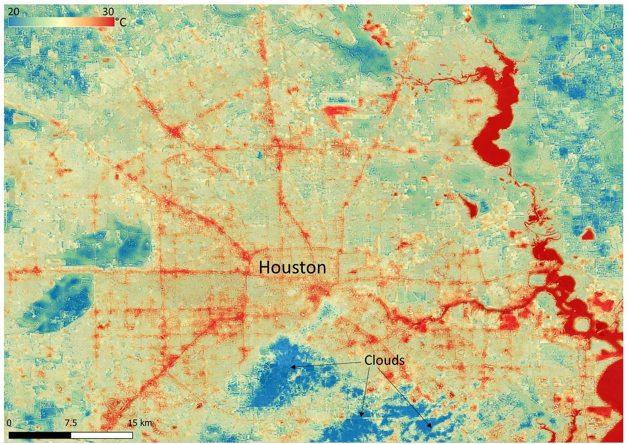
NASA's Ecosystem Spaceborne Thermal Radiometer Experiment on Space Station (ECOSTRESS) instrument recorded this image of ground surface temperatures in Houston and its environs on June 20, 2022, at 6:29 a.m. Central Daylight Time. Even just after sunrise, manmade urban surfaces near the city center and transportation networks – streets, roads, and highways shown in red and orange – were significantly warmer than the outskirts by up to 18 degrees Fahrenheit (10 degrees Celsius). Clouds, which are cool compared with the ground, are shown in blue and labeled in the image. Cities are usually warmer than open land because of human activities and the materials used in building and construction. Streets are often the hottest part of the built environment due to asphalt paving. Dark-colored surfaces absorb more heat from the Sun than lighter-colored ones; asphalt absorbs up to 95% of solar radiation and retains the heat for hours into the nighttime. ECOSTRESS measures the temperature of the ground, which is hotter than the air temperature during the daytime. The instrument launched to the space station in 2018. Its primary mission is to identify plants' thresholds for water use and water stress, giving insight into their ability to adapt to a warming climate. However, ECOSTRESS is also useful for documenting other heat-related phenomena, like patterns of heat absorption and retention. Its high-resolution images, with a pixel size of about 225 feet (70 meters) by 125 feet (38 meters), are a powerful tool for understanding our environment. https://photojournal.jpl.nasa.gov/catalog/PIA25421
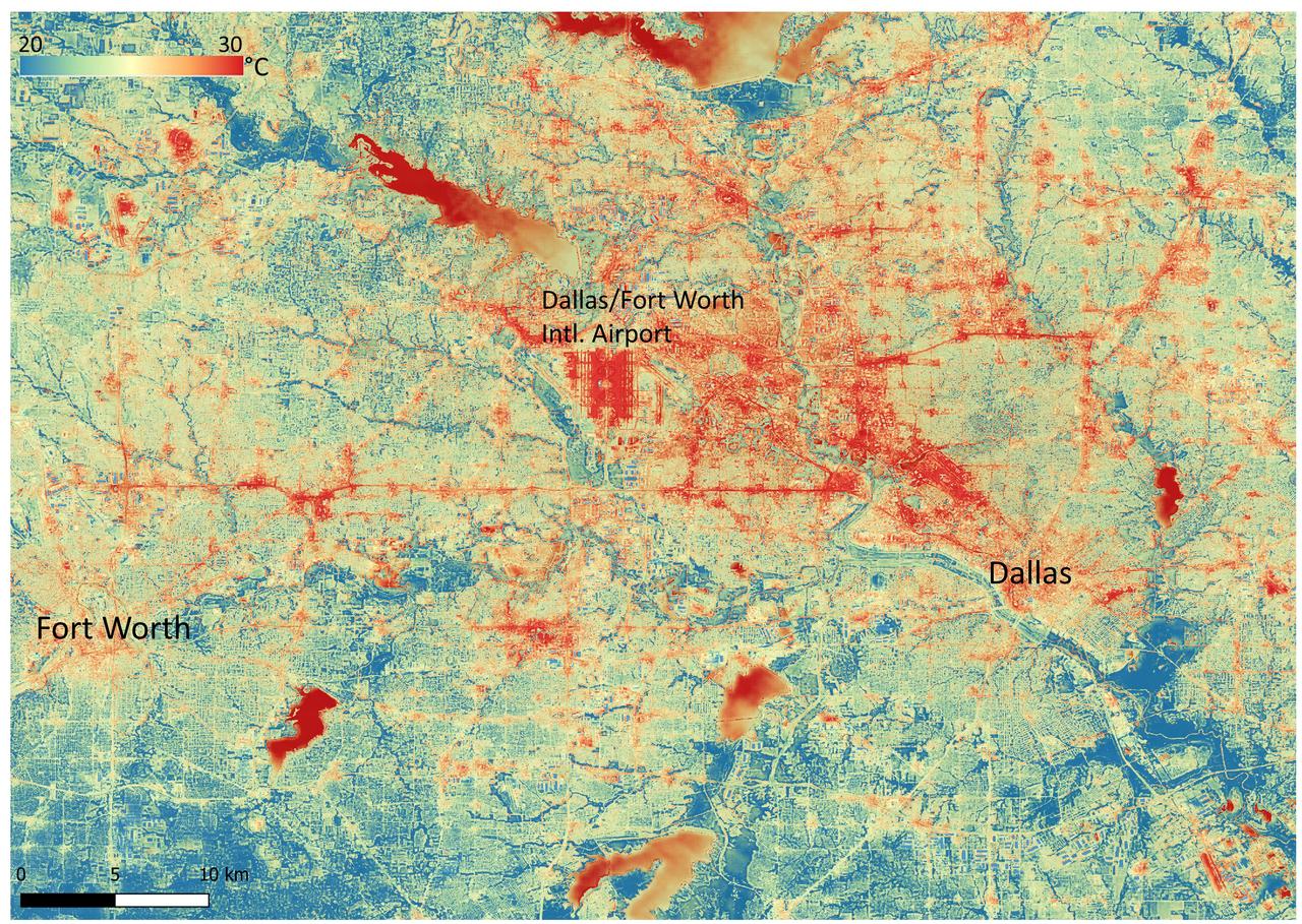
NASA's Ecosystem Spaceborne Thermal Radiometer Experiment on Space Station (ECOSTRESS) instrument recorded this image of ground surface temperatures in Dallas and Fort Worth, Texas, on June 20, 2022, at 7:17 a.m. Central Daylight Time. Even early in the day, manmade urban surfaces near city centers and transportation networks – streets, roads, and highways shown in red and orange – are warmer than the outskirts by up to 18 degrees Fahrenheit (10 degrees Celsius). The paved surfaces at Dallas/Fort Worth International Airport, shown in red near the top-center of the image, had the warmest temperatures, exceeding 86 F (30 C). Natural land surfaces such as vegetation and streams in rural areas, shown in green and blue, are cooler than nearby large bodies of water, shown in red and yellow, that tend to retain more heat overnight due to their higher heat capacity. Cities are usually warmer than open land because of human activities and the materials used in building and construction. Streets are often the hottest part of the built environment due to asphalt paving. Dark-colored surfaces absorb more heat from the Sun than lighter-colored ones; asphalt absorbs up to 95% of solar radiation and retains the heat for hours into the nighttime. ECOSTRESS measures the temperature of the ground, which is hotter than the air temperature during the daytime. The instrument launched to the space station in 2018. Its primary mission is to identify plants' thresholds for water use and water stress, giving insight into their ability to adapt to a warming climate. However, ECOSTRESS is also useful for documenting other heat-related phenomena, like patterns of heat absorption and retention. Its high-resolution images, with a pixel size of about 225 feet (70 meters) by 125 feet (38 meters), are a powerful tool for understanding our environment. https://photojournal.jpl.nasa.gov/catalog/PIA25422
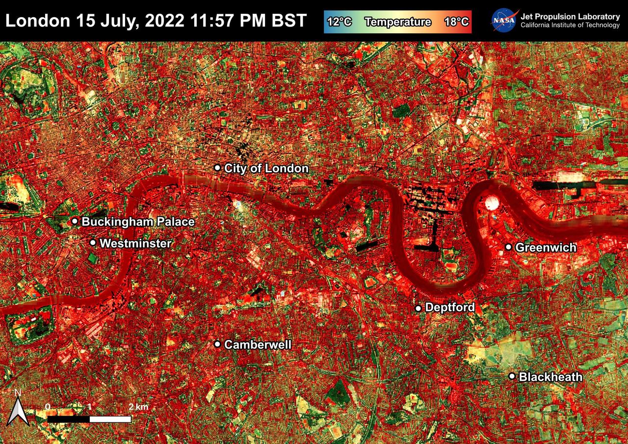
NASA's Ecosystem Spaceborne Thermal Radiometer Experiment on Space Station (ECOSTRESS) instrument recorded this image of ground surface temperatures in London and surrounding areas on July 15, 2022, just before midnight local time. It shows surface temperatures exceeding 68 degrees Fahrenheit (20 degrees Celsius) at 11:57 p.m. British Summer Time. Parts of Europe in mid-July experienced a record-breaking heat wave. The United Kingdom reaching its highest air temperature on record on July 19, 104.5 F (40.3 C) in Coningsby, about 110 miles (177 kilometers) north of London, which itself saw a high of 104.3 F (40.2 C) the same day. That evening, the overnight low was also a record-breaker: 78.4 F (25.8 C) at Kenley Airfield in Greater London. In this image, the red areas indicate hotter temperatures commonly associated with developed areas. These surfaces – roofs, paved streets, and other built structures – remain warm long after the sun sets. Blue and green areas indicate cooler areas commonly associated with parks and other natural land surfaces. Because this image was acquired at night, it shows bodies of water being warmer than the land surface. This is because water tends to change temperature more slowly, so its temperature stays elevated long after land surfaces have cooled down. Cities are usually warmer than open land with natural surfaces because of human activities as well as the materials used in building and construction. Streets are often the hottest part of the built environment due to asphalt paving. Dark-colored surfaces absorb more heat from the Sun than lighter-colored ones; asphalt absorbs up to 95% of solar radiation and retains the heat for hours into nighttime. This image overlays ECOSTRESS surface temperature data on a Google satellite map for context. ECOSTRESS measures the temperature of the ground, which is hotter than the air temperature during the daytime. The instrument launched to the space station in 2018. Its primary mission is to identify plants' thresholds for water use and water stress, giving insight into their ability to adapt to a warming climate. However, ECOSTRESS is also useful for documenting other heat-related phenomena, like patterns of heat absorption and retention. Its high-resolution images, with a pixel size of about 225 feet (70 meters) by 125 feet (38 meters), are a powerful tool for understanding our environment. https://photojournal.jpl.nasa.gov/catalog/PIA25423
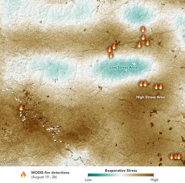
NASA's ECOsystem Spaceborne Thermal Radiometer Experiment on Space Station (ECOSTRESS) sensor measured the water-stress levels of plants when it passed over the Peruvian Amazon rainforest on Aug. 7, 2019, before the fires there began. The map shows areas of plants in distress (brown) and areas of less stress (blue). Water-stressed plants released measurably less water vapor into the air at the time of the summer fires. The fire icons represent fires imaged by NASA's Terra satellite between Aug. 19 and 26. The burn pattern reveals that the fires were concentrated in areas of highly water-stressed plants, pointing to how water-stressed plants can impact the spread of fires. The data may one day help NASA's Earth-observing missions predict the path of future forest or brush fires. https://photojournal.jpl.nasa.gov/catalog/PIA23432
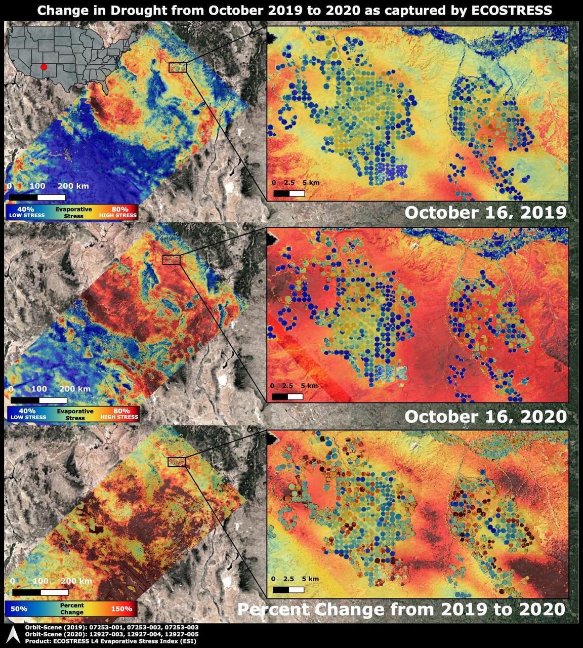
The Western United States has been entrenched in an Extreme and Exceptional drought that has extended from the summer and into the fall of 2020. NASA's ECOsystem Spaceborne Thermal Radiometer Experiment on Space Station (ECOSTRESS) imaged the drought on Oct. 16, 2020, and compared the same area to an image from ECOSTRESS taken a year earlier on Oct. 16, 2019. The bottom image shows the percentage change in plant water stress from 2019 to 2020. The images at left zoom into the Arizona and New Mexico border and Navajo Nation Territory area, featuring the ECOSTRESS Evaporative Stress Index (ESI), which shows plant water stress. The inset images on the right zoom further into the region, showing circular agricultural fields that have been irrigated. Blue colors represent low stress and high water use, whereas red colors represent high stress and low water use. Irrigation is able to alleviate plant water stress in many of the fields while the surrounding landscape suffers from the drought, though numerous agricultural fields are shut down in the drought image. The primary mission of ECOSTRESS, which launched to the International Space Station in June 2018, is to provide insight into plants' health, especially in a drought, by taking their temperature. Plants regulate their temperature by releasing water through tiny pores on their leaves. With sufficient water, they can maintain their temperature. When they lack water, their temperatures rise; ECOSTRESS can measure this change. https://photojournal.jpl.nasa.gov/catalog/PIA24132
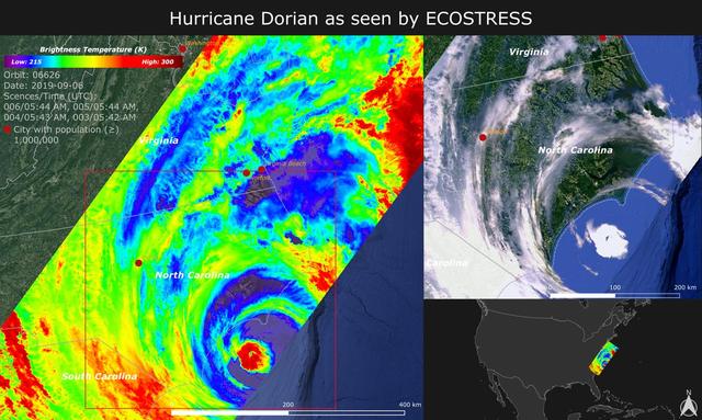
NASA's ECOsystem Spaceborne Thermal Radiometer Experiment on Space Station (ECOSTRESS) imaged the temperature of Hurricane Dorian from the International Space Station on Sept. 6, 2019 as the storm made landfall in North Carolina. ECOSTRESS senses the amount of emitted infrared radiation from Earth, which is converted into an equivalent temperature scale in units of degrees Kelvin. In the image, red colors such as the well-defined eye represent warmer temperatures while purple/blue represent the cooler cloud top temperatures of strong storm clouds with the potential of producing heavy rain. The temperature patterns reveal fine cloud structures that contribute to the formation of the larger hurricane. The width of the image (~400 km) is based on what ECOSTRESS sees as the Space Station flies over any given spot on Earth. ECOSTRESS launched to the space station in June 2018. It can measure variations in temperature to within a few tenths of a degree and is able to detect temperature changes at various times of day over areas as small as a football field. ECOSTRESS' primary mission is to detect plant health from space; however, its measurements can be used to detect other heat-related phenomena — including urban heat, fires, and volcanic activity — as well. Although disaster response is not one of its primary objectives, these highly detailed hurricane temperature estimates can be used to improve weather models. https://photojournal.jpl.nasa.gov/catalog/PIA23422

Data from NASA's ECOSTRESS (Ecosystem Spaceborne Thermal Radiometer Experiment on Space Station) instrument aboard the International Space Station shows three wildfires burning in the mountains east and southeast of the Los Angeles area on Sept. 10, 2024. The Bridge Fire started Sept. 8 in the Angeles National Forest during an intense heat wave that blanketed the area for about a week. As of Sept. 13, the fire was only 3% contained. The Line Fire started Sept. 5 in Highland, within San Bernardino County, and spread toward the mountain communities of Running Springs and Big Bear. After more than a week of battling the blaze, firefighters had the conflagration 21% contained. The Airport Fire ignited Sept. 9 in the foothills of the Santa Ana Mountains east of the Orange County city of Irvine and spread into Riverside County. As of Sept. 13, it was 8% contained. The ECOSTRESS instrument measures the temperature of the land rather than air temperatures that most people are familiar with in weather forecasts. Bright white spots in the active fire areas in the visual above indicate a land surface temperature of over 300 degrees Fahrenheit (149 degrees Celsius). Dark red represents areas closer to 100 F (38 C). https://photojournal.jpl.nasa.gov/catalog/PIA26187
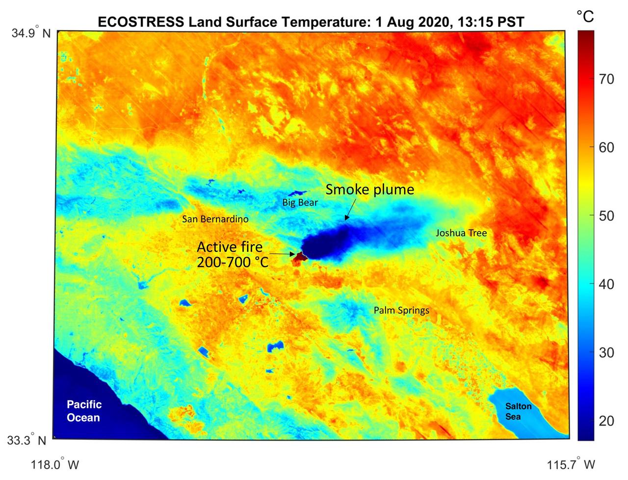
This temperature map shows the stressed and dry vegetation surrounding the Apple fire in Southern California on Aug. 1, 2020. The observation was made possible by NASA's Ecosystem Spaceborne Thermal Radiometer Experiment on Space Station (ECOSTRESS) that measured the temperature of the burn area and tracked the dark smoke plume drifting east from California to Arizona. ECOSTRESS collected this data when the space station passed over the region at about 1:15 p.m. PST on Saturday, Aug. 1, 2020, when the burn area was approximately 4,000 acres in size. Black smoke can be seen drifting east and over Joshua Tree National Park in the Mojave Desert. With a resolution of about 77 by 77 yards (70 by 70 meters), the image enables surface-temperature conditions down to the size of a football field to be studied. In the active burn area, temperatures of between 390-1290 F (200-700 C) were recorded, and in one pixel in the ECOSTRESS image of the burn zone, a peak temperature of 1387 F (753 C) was detected. Tasked with detecting plant water use and stress, ECOSTRESS measures the temperature of plants as they heat up when they run out of water. But it can also measure and track heat-related phenomena like fires, heat waves, and volcanoes. https://photojournal.jpl.nasa.gov/catalog/PIA23798
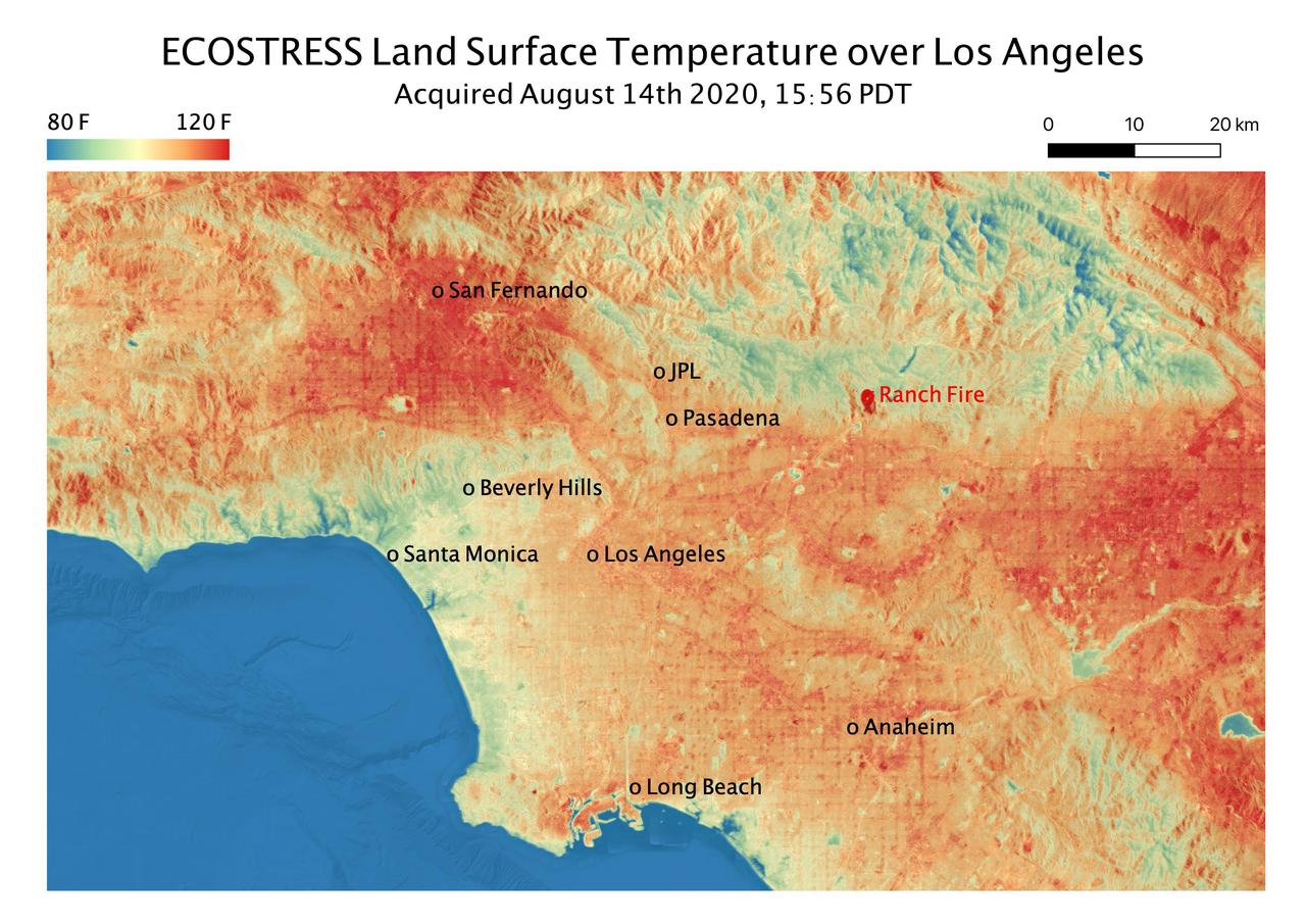
This temperature map shows the land surface temperatures throughout Los Angeles County on Aug. 14, 2020. The observation was made possible by NASA's Ecosystem Spaceborne Thermal Radiometer Experiment on Space Station (ECOSTRESS), which measured a peak land surface temperature in the San Fernando Valley, northwest of downtown Los Angeles, of 128.3 degrees Fahrenheit (53.5 degrees Celsius). ECOSTRESS collected this data as the space station passed over California at about 3:56 p.m. PDT (6:56 p.m. EDT) during a record-breaking heat wave that gripped the region. The Ranch fire, that burned near the city of Azuza was also detected by ECOSTRESS. With a resolution of about 77 by 77 yards (70 by 70 meters), the image enables the study of surface-temperature conditions down to the size of a football field. The hottest temperatures are shown in dark red, with the coolest temperatures in blue. ECOSTRESS measures the temperature of plants as they heat up when they run out of water. But it can also measure and track heat-related phenomena like heat waves, fires, and volcanoes. https://photojournal.jpl.nasa.gov/catalog/PIA23786
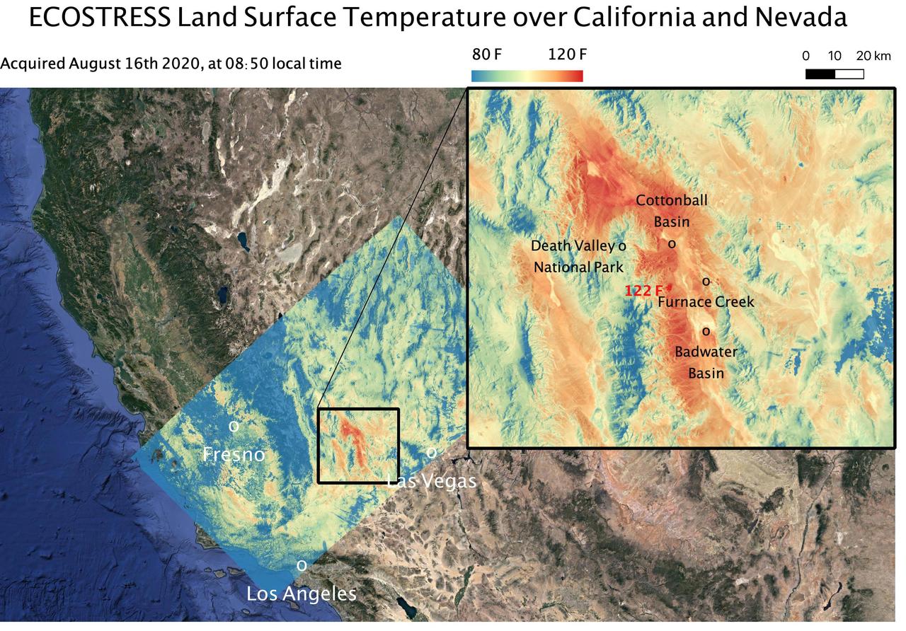
This temperature map shows the land surface temperatures around Death Valley in California's Mojave Desert on Aug. 16, 2020. The observation was made possible by NASA's Ecosystem Spaceborne Thermal Radiometer Experiment on Space Station (ECOSTRESS), which measured a peak land surface temperature of 122.52 degrees Fahrenheit (50.29 degrees Celsius) near Furnace Creek. ECOSTRESS collected this data when the space station passed over California at about 8:50 a.m. PDT (11:50 a.m. EDT) during a record-breaking heat wave that gripped the region. With a resolution of about 77 by 77 yards (70 by 70 meters), the image enables the study of surface-temperature conditions down to the size of a football field. The hottest temperatures are shown in dark red, with the coolest temperatures in blue. ECOSTRESS measures the temperature of plants as they heat up when they run out of water. But it can also measure and track heat-related phenomena like heat waves, fires, and volcanoes. https://photojournal.jpl.nasa.gov/catalog/PIA23787
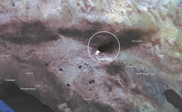
This observation shows the burn area and smoke plume created by the Apple fire in Southern California on Aug. 1, 2020. The observation was made possible by NASA's Ecosystem Spaceborne Thermal Radiometer Experiment on Space Station (ECOSTRESS). Data gathered by the mission can be further refined to measure the temperature of the wildfire, smoke plume and surrounding landscape. ECOSTRESS collected this data when the space station passed over the region at about 1:15 p.m. PST on Saturday, Aug. 1, 2020, when the burn area was approximately 4,000 acres in size. As of Aug. 3, it was more than 26,000 acres. Black smoke can be seen drifting east and over Joshua Tree National Park in the Mojave Desert. With a resolution of about 77 by 77 yards (70 by 70 meters), the image enables surface-temperature conditions down to the size of a football field to be studied. Tasked with detecting plant water use and stress, ECOSTRESS measures the temperature of plants as they heat up when they run out of water. But it can also measure and track heat-related phenomena like fires, heat waves, and volcanoes. https://photojournal.jpl.nasa.gov/catalog/PIA23799
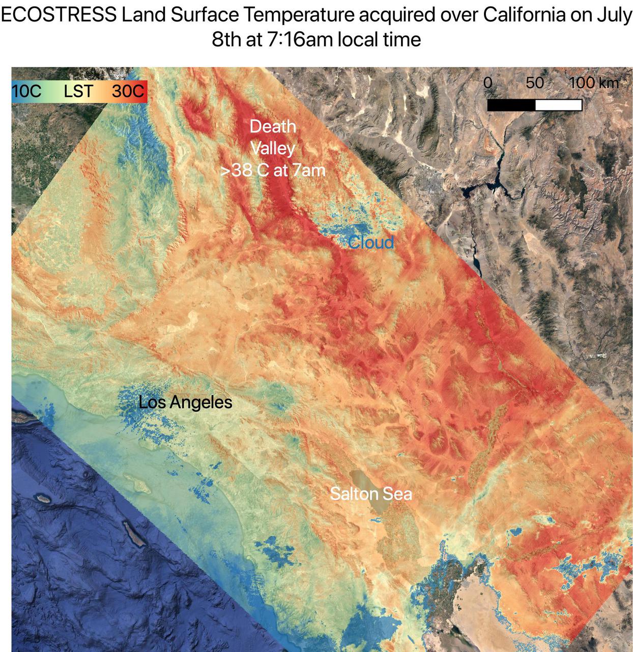
On July 8, NASA's ECOsystem Spaceborne Thermal Radiometer Experiment on Space Station (ECOSTRESS) instrument captured ground surface temperature data over California. In the image, areas in red – including Death Valley – had surpassed 86 degrees Fahrenheit (30 degrees Celsius) by 7:16 a.m. local time, well above average ground surface temperatures for the area. Tasked with detecting plant water use and stress, ECOSTRESS's primary mission is to measure the temperature of plants heating up as they run out of water. But it can also measure and track heat-related phenomena like heat waves, wildfires, and volcanoes. ECOSTRESS observations have a spatial resolution of about 77 by 77 yards (70 by 70 meters), which enables researchers to study surface-temperature conditions down to the size of a football field. Due to the space station's unique orbit, the mission can acquire images of the same regions at different times of the day, as opposed to crossing over each area at the same time of day like satellites in other orbits do. This is advantageous when monitoring plant stress in the same area throughout the day, for example. https://photojournal.jpl.nasa.gov/catalog/PIA23694

NASA's ECOsystem Spaceborne Thermal Radiometer Experiment on Space Station (ECOSTRESS) has imaged a temperature profile of an area surrounding a fire-induced tornado in Loyalton, California. A 20,000-acre wildfire early on Saturday, Aug. 15, 2020, had been the source of the tornado. Fire tornados are rare occurrences and happen due to the most unfavorable weather conditions: harsh winds and a surge in heat from a fire. They have the potential to be highly dangerous, leading to many areas to issue a weather alert to their residents to stay cautious and find places of shelter. In this map, there is a concentrated area of high temperature, which is likely where the fire-induced tornado had taken place. Also present in the image are very cold clouds, possibly representing the pyrocumulonimbus cloud that usually forms above a fire tornado. The National Weather Service (NWS) also suggested outflow winds in excess of 60 mph, which points to the event to be an EF1 or EF2 tornado. https://photojournal.jpl.nasa.gov/catalog/PIA23215
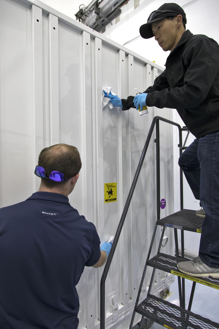
In the Space Station Processing Facility at NASA's Kennedy Space Center in Florida, the ECOsystem Spaceborne Thermal Radiometer Experiment on Space Station (ECOSTRESS) has arrived in its shipping container. The container is being inspected and thoroughly cleaned prior to opening. ECOSTRESS is designed to monitor one of the most basic processes in living plants: the loss of water through the tiny pores in leaves. ECOSTRESS will launch to the International Space Station aboard a Dragon spacecraft launched by a Falcon 9 rocket on the SpaceX CRS-15 mission in June 2018.

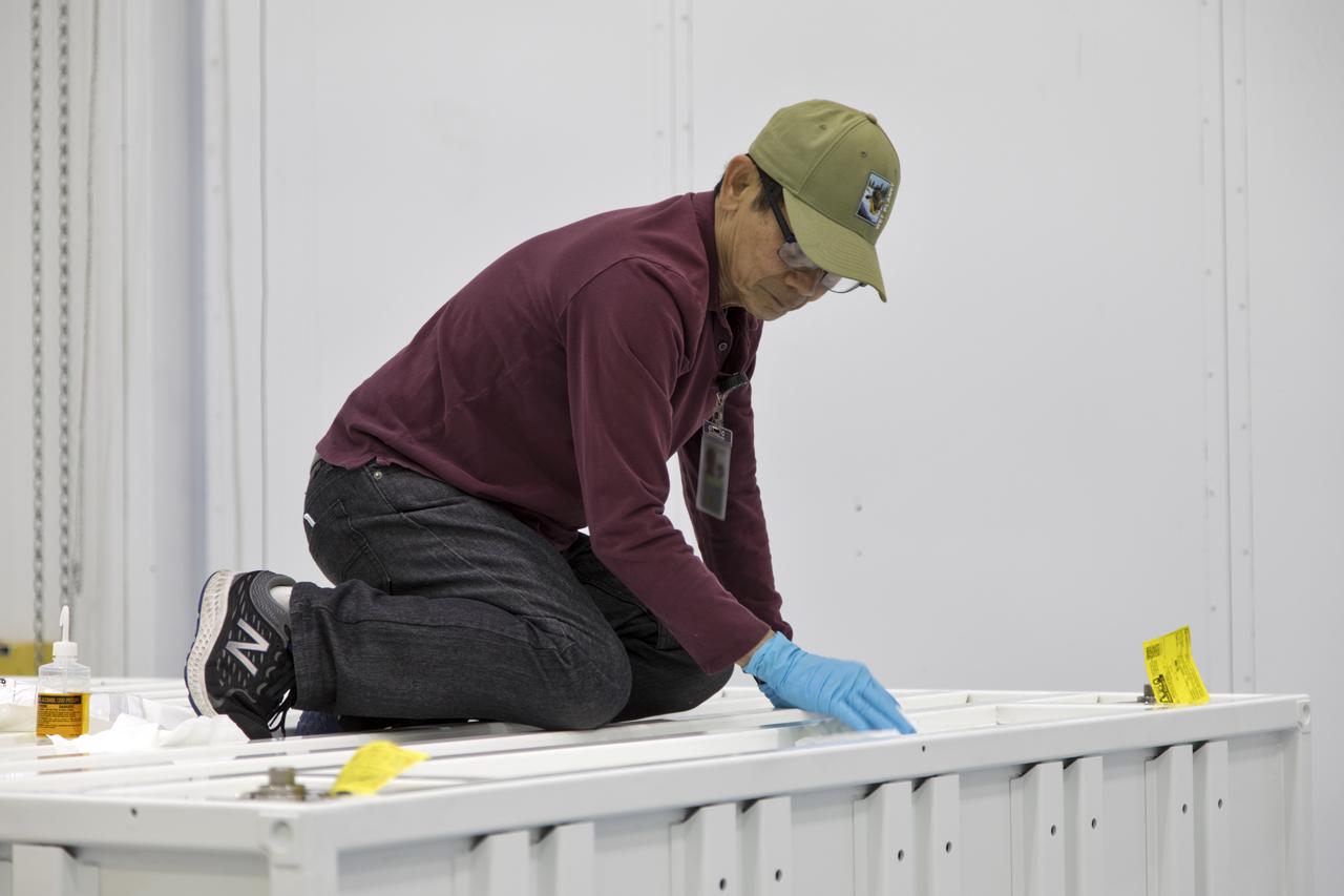
In the Space Station Processing Facility at NASA's Kennedy Space Center in Florida, the ECOsystem Spaceborne Thermal Radiometer Experiment on Space Station (ECOSTRESS) is inspected shortly after arrival. ECOSTRESS is designed to monitor one of the most basic processes in living plants: the loss of water through the tiny pores in leaves. ECOSTRESS will launch to the International Space Station aboard a Dragon spacecraft launched by a Falcon 9 rocket on the SpaceX CRS-15 mission in June 2018.
In the Space Station Processing Facility at NASA's Kennedy Space Center in Florida, the ECOsystem Spaceborne Thermal Radiometer Experiment on Space Station (ECOSTRESS) has arrived in its shipping container. The container is being inspected and thoroughly cleaned prior to opening. ECOSTRESS is designed to monitor one of the most basic processes in living plants: the loss of water through the tiny pores in leaves. ECOSTRESS will launch to the International Space Station aboard a Dragon spacecraft launched by a Falcon 9 rocket on the SpaceX CRS-15 mission in June 2018.
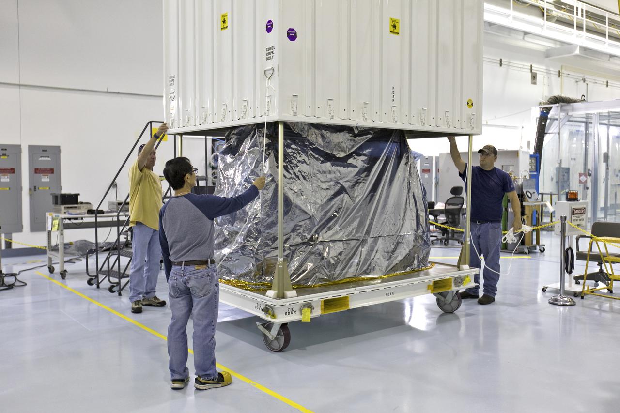
In the Space Station Processing Facility at NASA's Kennedy Space Center in Florida, the ECOsystem Spaceborne Thermal Radiometer Experiment on Space Station (ECOSTRESS) is removed from its shipping container. ECOSTRESS is designed to monitor one of the most basic processes in living plants: the loss of water through the tiny pores in leaves. ECOSTRESS will launch to the International Space Station aboard a Dragon spacecraft launched by a Falcon 9 rocket on the SpaceX CRS-15 mission in June 2018.
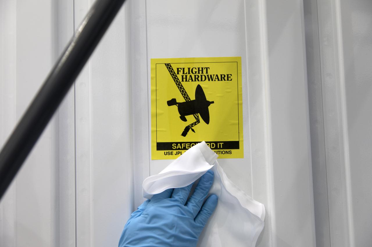
In the Space Station Processing Facility at NASA's Kennedy Space Center in Florida, the ECOsystem Spaceborne Thermal Radiometer Experiment on Space Station (ECOSTRESS) has arrived in its shipping container. The container is being inspected and thoroughly cleaned prior to opening. ECOSTRESS is designed to monitor one of the most basic processes in living plants: the loss of water through the tiny pores in leaves. ECOSTRESS will launch to the International Space Station aboard a Dragon spacecraft launched by a Falcon 9 rocket on the SpaceX CRS-15 mission in June 2018.
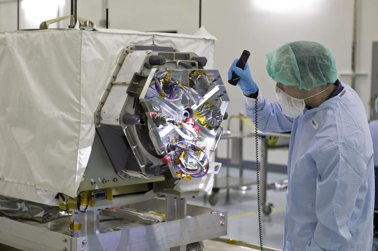
In the Space Station Processing Facility at NASA's Kennedy Space Center in Florida, the ECOsystem Spaceborne Thermal Radiometer Experiment on Space Station (ECOSTRESS) is inspected shortly after arrival. ECOSTRESS is designed to monitor one of the most basic processes in living plants: the loss of water through the tiny pores in leaves. ECOSTRESS will launch to the International Space Station aboard a Dragon spacecraft launched by a Falcon 9 rocket on the SpaceX CRS-15 mission in June 2018.

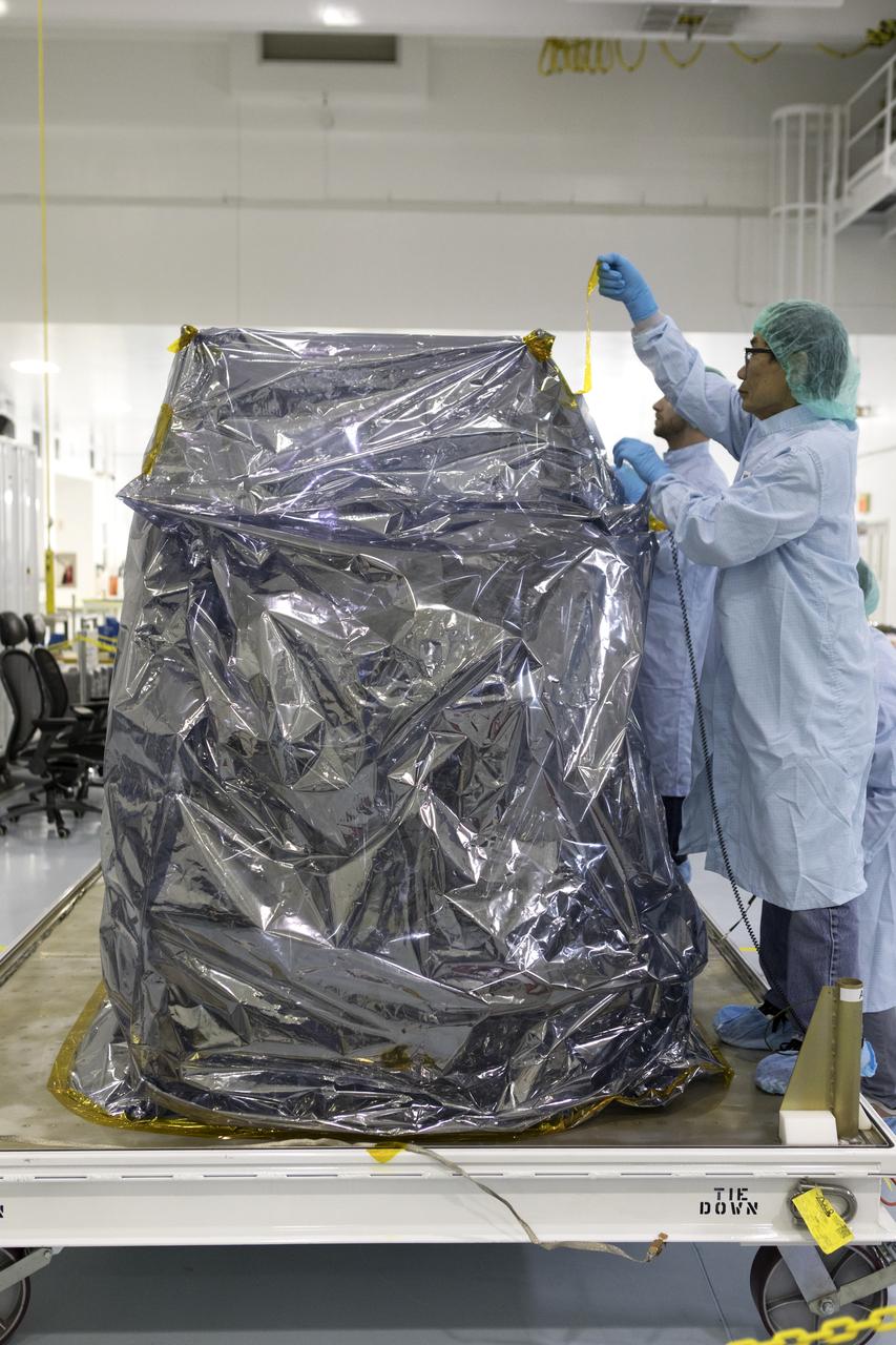
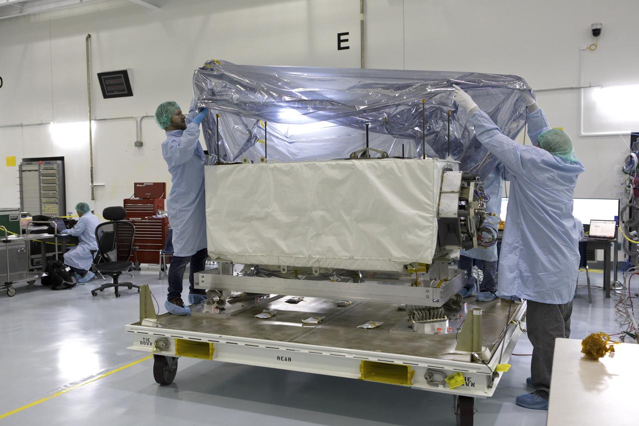
In the Space Station Processing Facility at NASA's Kennedy Space Center in Florida, technicians and engineers removed protective wrapping from the ECOsystem Spaceborne Thermal Radiometer Experiment on Space Station (ECOSTRESS). ECOSTRESS is designed to monitor one of the most basic processes in living plants: the loss of water through the tiny pores in leaves. ECOSTRESS will launch to the International Space Station aboard a Dragon spacecraft launched by a Falcon 9 rocket on the SpaceX CRS-15 mission in June 2018.
In the Space Station Processing Facility at NASA's Kennedy Space Center in Florida, the ECOsystem Spaceborne Thermal Radiometer Experiment on Space Station (ECOSTRESS) is removed from its shipping container. ECOSTRESS is designed to monitor one of the most basic processes in living plants: the loss of water through the tiny pores in leaves. ECOSTRESS will launch to the International Space Station aboard a Dragon spacecraft launched by a Falcon 9 rocket on the SpaceX CRS-15 mission in June 2018.
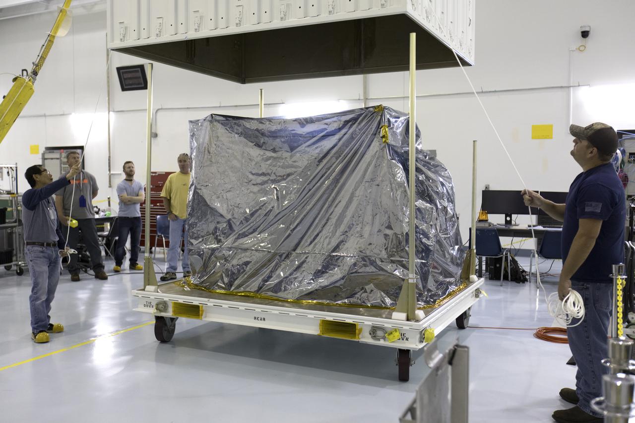
In the Space Station Processing Facility at NASA's Kennedy Space Center in Florida, the ECOsystem Spaceborne Thermal Radiometer Experiment on Space Station (ECOSTRESS) is removed from its shipping container. ECOSTRESS is designed to monitor one of the most basic processes in living plants: the loss of water through the tiny pores in leaves. ECOSTRESS will launch to the International Space Station aboard a Dragon spacecraft launched by a Falcon 9 rocket on the SpaceX CRS-15 mission in June 2018.
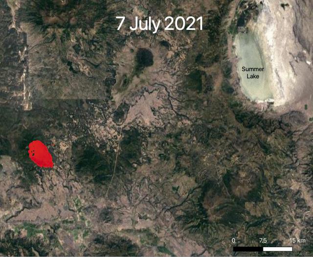
NASA's ECOsystem Spaceborne Thermal Radiometer Experiment on Space Station (ECOSTRESS) is aiding in the fight against fires in the Western U.S. As of July 27, 2021, the Bootleg Fire in southern Oregon had ballooned to more than 410,000 acres, damaging hundreds of buildings and vehicles in its path. ECOSTRESS measures surface temperature from the vantage point of the International Space Station. Researchers of the RADR-Fire team at Pacific Northwest National Laboratory have been experimenting with ECOSTRESS data as part of a new tool now being implemented for first responders like the U.S. Forest Service. In the visualization, ECOSTRESS is tracking the movement of the Bootleg Fire between July 7 and July and identifying its proximity to critical infrastructure — areas in red represent the hottest pixels ECOSTRESS detected. The extreme heat in those areas indicates the fire front, or where resources are most needed. Tasked with detecting plant water use and stress, ECOSTRESS's primary mission is to measure the temperature of plants heating up as they run out of water. But it can also measure and track heat-related phenomena like wildfires, heat waves, and volcanoes. ECOSTRESS observations have a spatial resolution of about 77 by 77 yards (70 by 70 meters), which enables researchers to study surface-temperature conditions down to the size of a football field. Due to the space station's unique orbit, the mission can acquire images of the same regions at different times of the day, as opposed to crossing over each area at the same time of day like satellites in other orbits do. This is advantageous when monitoring plant stress in the same area throughout the day, for example. Movie available at https://photojournal.jpl.nasa.gov/catalog/PIA23695
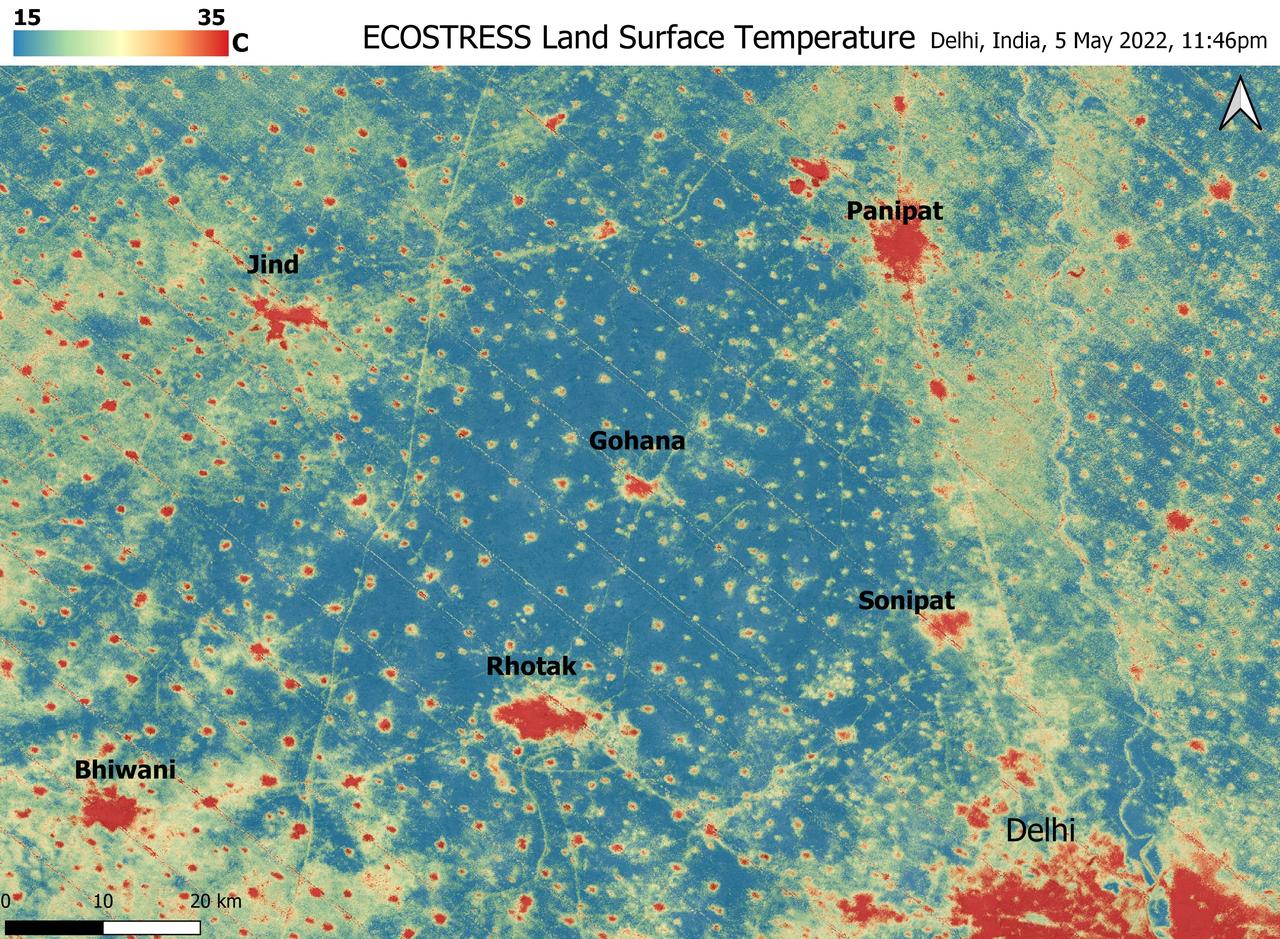
A relentless heat wave has blanketed India and Pakistan since mid-March 2022, causing dozens of deaths, fires, increased air pollution, and reduced crop yields. NASA's Ecosystem Spaceborne Thermal Radiometer Experiment on Space Station instrument (ECOSTRESS) has been measuring these temperatures from space, at the highest spatial resolution of any satellite instrument. This image, taken shortly before local midnight on May 5, shows urban areas and agricultural lands northwest of Delhi that are home to about 28 million people. The image covers about 4,800 square miles (12,350 square kilometers). Cities are usually markedly warmer than the surrounding countryside due to human activities and the materials used in the built environment. The image clearly delineates these urban "heat islands." Nighttime temperatures in Delhi and several smaller villages were above 95 degrees Fahrenheit (35 degrees Celsius), peaking at about 102 degrees F (39 degrees C), while the rural fields nearby had cooled to around 60 degrees F (15 degrees C). This data suggests that city dwellers are experiencing considerably higher temperatures than the average temperatures reported for their regions. ECOSTRESS measures the temperature of the ground itself, which is very similar to air temperature at night (though the ground may be warmer than the air in daylight hours). The instrument launched to the space station in 2018. Its primary mission is to identify plants' thresholds for water use and water stress, giving insight into their ability to adapt to a warming climate. However, ECOSTRESS also records other heat-related phenomena like this heat wave. Its high-resolution images, with a pixel size of about 225 feet (70 meters) by 125 feet (38 meters), are a powerful tool for understanding aspects of the weather event that might be overlooked by traditional observation networks. https://photojournal.jpl.nasa.gov/catalog/PIA24987
ECOSTRESS Unbagging
Late in the evening on September 27, 2020 the Glass Fire ignited in the foothills of Napa Valley, California. The cause of the fire is still unknown. Within 24 hours it exploded to over 11,000 acres fueled by dehydrated soil and the drought-stricken landscape. Within hours of the start of the fire, ECOSTRESS captured several hotspots near the fire's origin (represented by the brightest yellow spots on the map). Not only is it important to monitor the progress of the fire as it to help protect people and property, dense wildfire smoke can also damage crops. For this reason, it is important to track both the movement of the fire and local weather patterns to predict crop damage from smoke exposure. Wildfires are common in this region of California, however this unseasonable fire ripped through the region with unusual speed and intensity. As wildfire behavior continues to adapt with Climate Change, images like this help scientists and farmers understand the impacts that the new fire season has on crops. This information is helpful in developing plans to increase agricultural resilience to climate change. Tasked with detecting plant water use and stress, ECOSTRESS's primary mission is to measure the temperature of plants heating up as they run out of water. But it can also measure and track heat-related phenomena like wildfires, heat waves, and volcanoes. ECOSTRESS observations have a spatial resolution of about 77 by 77 yards (70 by 70 meters), which enables researchers to study surface-temperature conditions down to the size of a football field. Due to the space station's unique orbit, the mission can acquire images of the same regions at different times of the day, as opposed to crossing over each area at the same time of day like satellites in other orbits do. This is advantageous when monitoring plant stress in the same area throughout the day, for example. https://photojournal.jpl.nasa.gov/catalog/PIA24209
ECOSTRESS captured surface temperature variations in Los Angeles, California between July 22 and August 14 -- a period of extended heat -- at different times of day. The images show how different surfaces within the cityscape warm and cool throughout the day. They have been colored to show the hottest areas in red, warm areas in orange and yellow, and cooler areas in blue. The hottest areas are dark asphalt surfaces that have very little shade during the day and remain warm throughout the night due to their higher heat capacity. They include freeways, airports, oil refineries and parking lots. Clouds and higher-elevation mountainous areas were the coolest. More information is available at https://photojournal.jpl.nasa.gov/catalog/PIA22703
The Sheep Fire started on June 12th, 2022, Northeast of the town of Wrightwood in San Bernardino County. The fire burned 865 acres and was contained on June 19th, 2022. Due to the proximity of the Sheep Fire to Wrightwood, the town was evacuated. The Pacific Crest Trail in the San Gabriel Mountains and part of Highway 2 were closed due to the fire. There were no casualties or injuries as a result of the Sheep Fire. The fire was captured in an ECOSTRESS Land Surface Temperature image on 08:27 AM PDT on June 15th and shows the temperature of the fire surpassing 100 degrees Fahrenheit. As California is currently in a drought, there are concerns that 2022 will see a severe wildfire season; ECOSTRESS allows for the monitoring of the drought and of wildfires. ECOSTRESS is a thermal instrument on the International Space Station that measures the temperature of the ground, which is hotter than the air temperature during the day. It was launched to the space station in 2018. Its primary mission is to identify critical thresholds of water use and water stress in plants and to detect the timing, location, and predictive factors leading to plant water uptake decline and/or cessation. The nature of the high-resolution data provided by ECOSTRESS allows it to record heat related phenomena such as heat waves, droughts and wildfires. https://photojournal.jpl.nasa.gov/catalog/PIA25356
On August 27, 2021 Ida crossed over Cuba as a Category 1 Storm. 48 hours later the storm intensified to a Category 4 before making landfall on the coast of Louisiana. The storm was the second most destructive storm to ever make landfall on the Louisiana coast with sustained winds over 150 mph (240 km/h). The rapid intensification process that the storm system underwent is not well understood. Satellite images such as this are helpful as scientists attempt to understand new weather patterns that are emerging with Global Climate Change. Tasked with detecting plant water use and stress, ECOSTRESS's primary mission is to measure the temperature of plants heating up as they run out of water. But it can also measure and track heat-related phenomena like wildfires, heat waves, and volcanoes. ECOSTRESS observations have a spatial resolution of about 77 by 77 yards (70 by 70 meters), which enables researchers to study surface-temperature conditions down to the size of a football field. Due to the space station's unique orbit, the mission can acquire images of the same regions at different times of the day, as opposed to crossing over each area at the same time of day like satellites in other orbits do. This is advantageous when monitoring plant stress in the same area throughout the day, for example. https://photojournal.jpl.nasa.gov/catalog/PIA24210
The Colorado Fire began on January 21st, 2022 was started by an escaped fire by the Palo Colorado Road. The wildfire burned 687 acres between Carmel-by-the-Sea and Big Sur. The Colorado Fire was driven towards the coast by strong winds leading to the shut down of the Bixby Bridge and a section of Highway 1. The fire was completely contained as of February 5th, 2022. No injuries or causalities have been reported; one structure was destroyed. The image above shows the fire captured in a Land Surface Temperature image from ECOSTRESS on February 3rd, 2022 at 01:11 PM PDT. As California is currently in a drought, there are concerns that 2022 will see a severe wildfire season; ECOSTRESS allows for the monitoring of the drought and of wildfires. ECOSTRESS is a thermal instrument on the International Space Station that measures the temperature of the ground, which is hotter than the air temperature during the day. It was launched to the space station in 2018. Its primary mission is to identify critical thresholds of water use and water stress in plants and to detect the timing, location, and predictive factors leading to plant water uptake decline and/or cessation. The nature of the high-resolution data provided by ECOSTRESS allows it to record heat related phenomena such as heat waves, droughts and wildfires. https://photojournal.jpl.nasa.gov/catalog/PIA25280
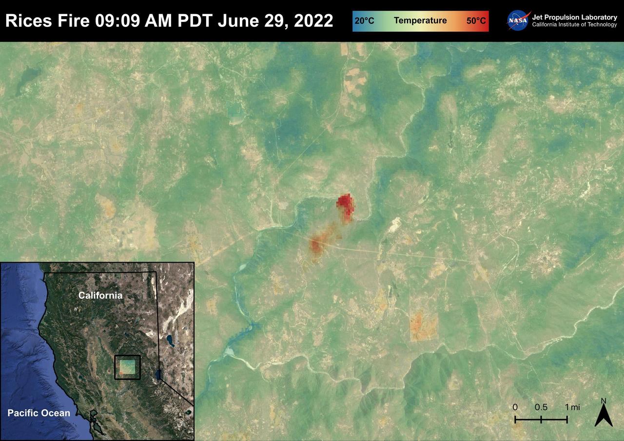
The Rices Fire started on June 28th, 2022 in Northern California near the Yuba River in Nevada County. The fire has burned over 900 acres and has destroyed one structure. French Corral, Birchville, and other communities were evacuated, but orders have since been lifted. There have been some firefighter injuries reported, but not casualties. The fire was captured in an ECOSTRESS Land Surface image on June 29 at 09:09 AM PDT and shows the temperatures surpassing 130 degrees Fahrenheit. ECOSTRESS is a thermal instrument on the International Space Station that measures the temperature of the ground, which is hotter than the air temperature during the day. It was launched to the space station in 2018. Its primary mission is to identify critical thresholds of water use and water stress in plants and to detect the timing, location, and predictive factors leading to plant water uptake decline and/or cessation. The nature of the high-resolution data provided by ECOSTRESS allows it to record heat related phenomena such as heat waves and wildfires. https://photojournal.jpl.nasa.gov/catalog/PIA25485
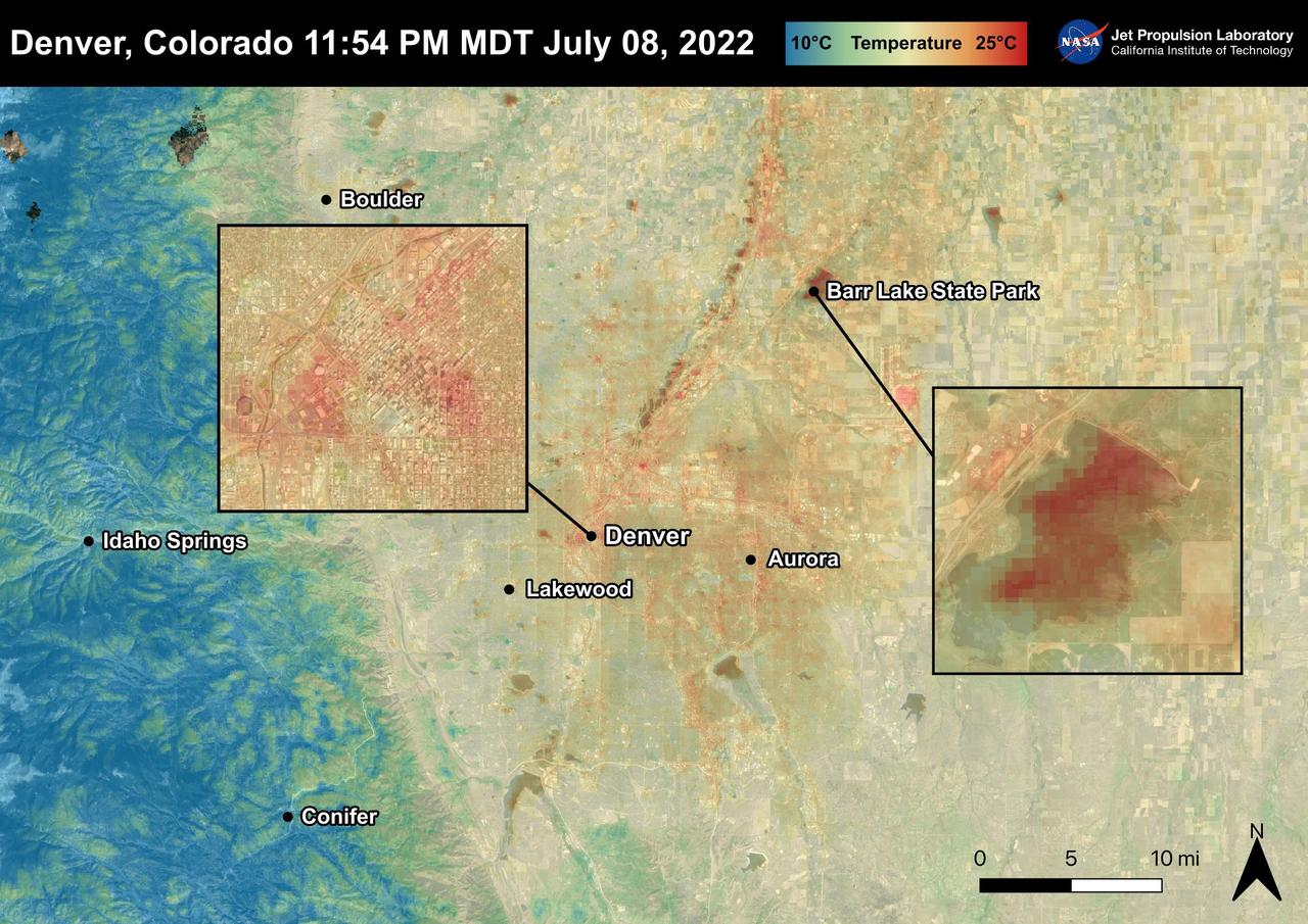
Denver, Colorado reached 96 degrees Fahrenheit on July 8th, 2022. In the two days following, temperatures rose to 101 degrees Fahrenheit. For cities like Denver, heat dissipates more slowly and create urban heat islands. High temperatures due to urban heat, especially at night, can lead to adverse health effects in vulnerable populations like children and the elderly. This image also shows that bodies of water, like Barr Lake, remain warm into the night due to water's high heat capacity. ECOSTRESS captured this Land Surface Temperature image on July 8th, 2022 at 11:54 PM MDT. ECOSTRESS is a thermal instrument on the International Space Station that measures the temperature of the ground, which is hotter than the air temperature during the day. It was launched to the space station in 2018. Its primary mission is to identify critical thresholds of water use and water stress in plants and to detect the timing, location, and predictive factors leading to plant water uptake decline and/or cessation. The nature of the high-resolution data provided by ECOSTRESS allows it to record heat related phenomena such as heat waves and wildfires. https://photojournal.jpl.nasa.gov/catalog/PIA25483
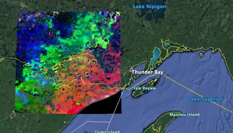
The image shows plants "waking up" west of Lake Superior near the U.S.-Canada border. Plants in the red and pink areas began to wake up around 7 a.m. local time. Those in green areas became active closer to 8 am., while those in blue areas did so closer to 9 a.m. The mission team collected and combined all of ECOSTRESS's morning data for the summer season. In doing so, they observed that the earliest risers were near the lake, with plant activity spreading gradually northwestward as the morning progressed. https://photojournal.jpl.nasa.gov/catalog/PIA23430

NASA's ECOSTRESS captured data over Northern California's Dixie Fire, which had ballooned to over 220,000 acres as of July 29, 2021. In the data visualization, the red areas show the hottest pixels – and fire movement – from July 15 to July 24. The most heavily affected areas are south of Lake Almanor in Plumas County. Tasked with detecting plant water use and stress from the vantage point of the International Space Station, ECOSTRESS's primary mission is to measure the temperature of plants heating up as they run out of water. But it can also measure and track heat-related phenomena like wildfires, heat waves, and volcanoes. ECOSTRESS observations have a spatial resolution of about 77 by 77 yards (70 by 70 meters), which enables researchers to study surface-temperature conditions down to the size of a football field. Due to the space station's unique orbit, the mission can acquire images of the same regions at different times of the day, as opposed to crossing over each area at the same time of day like satellites in other orbits do. This is advantageous when monitoring plant stress in the same area throughout the day, for example. Movie available at https://photojournal.jpl.nasa.gov/catalog/PIA23696
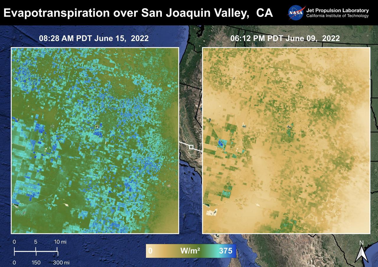
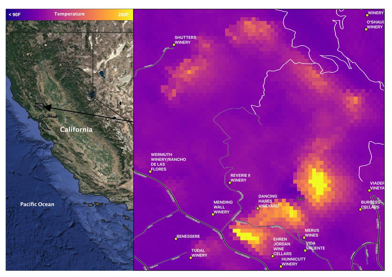
The Central Valley, CA is one of the most productive agricultural regions in the United States and the world. As California is in a continuing drought, it is important to monitor agricultural plant life to ensure maximized productivity. ECOSTRESS has the ability to monitor Evapotranspiration over agricultural fields. This Evapotranspiration image on the right was captured on June 09, 2022 at 06:12 PM PDT. The image on the left was captured by ECOSTRESS on June 15, 2022 at 08:27 AM PDT. Blue indicates high water use while brown indicates dry conditions. ECOSTRESS is a thermal instrument on the International Space Station that measures the temperature of the ground, which is hotter than the air temperature during the day. It was launched to the space station in 2018. Its primary mission is to identify critical thresholds of water use and water stress in plants and to detect the timing, location, and predictive factors leading to plant water uptake decline and/or cessation. The nature of the high-resolution data provided by ECOSTRESS allows it to record heat related phenomena such as heat waves and wildfires. https://photojournal.jpl.nasa.gov/catalog/PIA25486
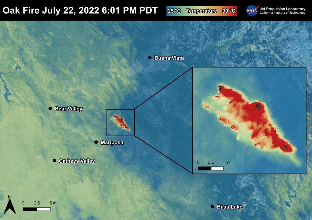
The Oak Fire started on July 22nd, 2022 at 2:10 PM PDT near Carstens Road and Highway 140 in Mariposa County, west of Yosemite. The fire has burned over 19,000 acres. In the first few days of the Oak Fire, over 1,400 structures were threatened, 3 were damaged, and 41 destroyed. Evacuation orders and road closures were issued throughout the region. The Oak Fire was captured in an ECOSTRESS Land Surface Temperature image on July 22nd with temperatures exceeding 90 degrees Celsius. ECOSTRESS is a thermal instrument on the International Space Station that measures the temperature of the ground, which is hotter than the air temperature during the day. It was launched to the space station in 2018. Its primary mission is to identify critical thresholds of water use and water stress in plants and to detect the timing, location, and predictive factors leading to plant water uptake decline and/or cessation. The nature of the high-resolution data provided by ECOSTRESS allows it to record heat related phenomena such as heat waves and wildfires. https://photojournal.jpl.nasa.gov/catalog/PIA25481
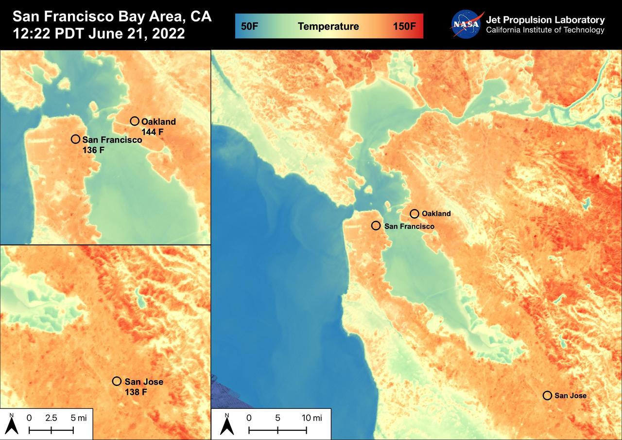
On June 21st, 2022, the San Francisco Bay Area experienced high temperatures as a hot mass of air remained over the region. San Francisco reached 92 degrees Fahrenheit, Oakland reached 98 degrees Fahrenheit, and San Jose reached 102 degrees Fahrenheit. The Land Surface Temperatures at 12:22 PM PDT ranged from 60 degrees Fahrenheit to 150 degrees Fahrenheit for this region with water temperatures ranging from 50 degrees Fahrenheit to 90 degrees Fahrenheit. ECOSTRESS is a thermal instrument on the International Space Station that measures the temperature of the ground, which is hotter than the air temperature during the day. It was launched to the space station in 2018. Its primary mission is to identify critical thresholds of water use and water stress in plants and to detect the timing, location, and predictive factors leading to plant water uptake decline and/or cessation. The nature of the high-resolution data provided by ECOSTRESS allows it to record heat related phenomena such as heat waves, droughts and wildfires. https://photojournal.jpl.nasa.gov/catalog/PIA25441
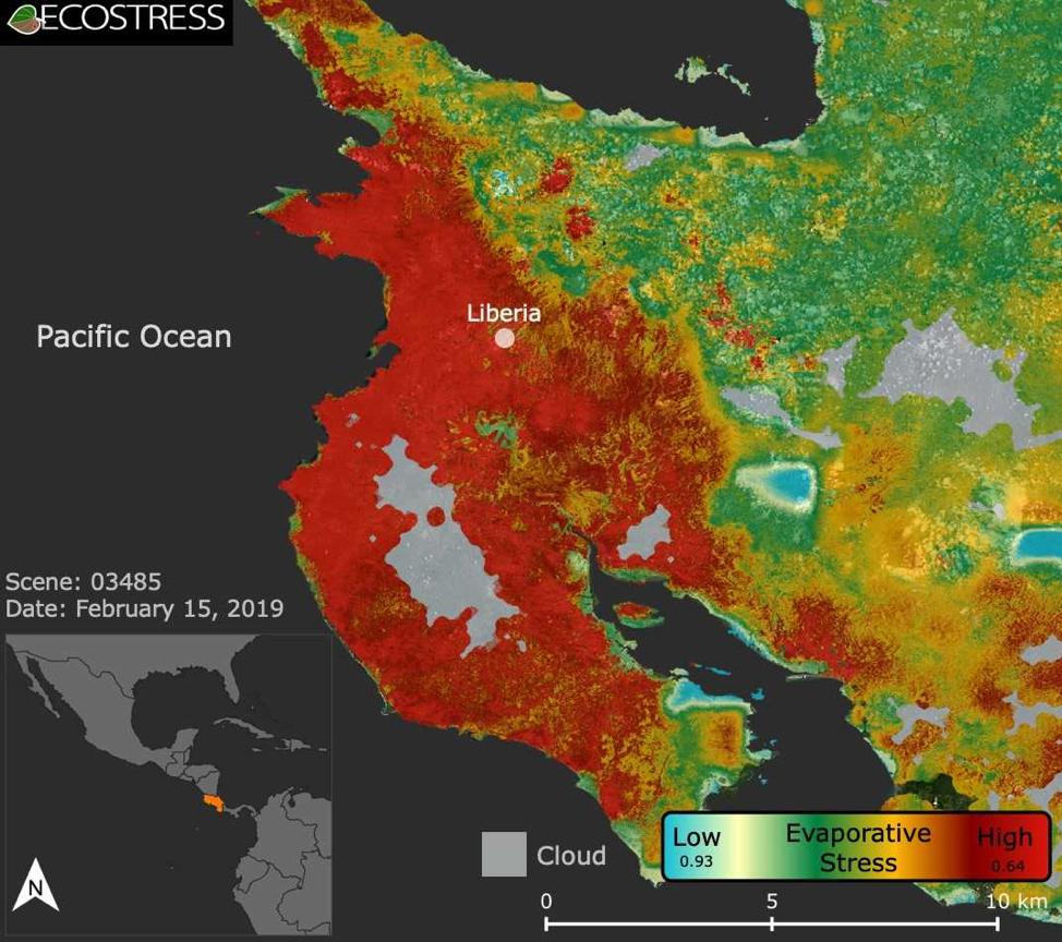
This image shows the ECOSTRESS evaporative stress index for the Guanacaste region of Costa Rica (in red on inset map, left) a few months after the onset of a major Central American drought. Red indicates high plant water stress, yellow is moderate stress and greens/blues are low stress. Light gray is cloud cover. The index measures how much water plants are using relative to how much they would use under optimal conditions; low numbers correlate with high stress. ECOSTRESS launched on June 29, 2018, as part of a SpaceX commercial resupply mission to the International Space Station. Its primary mission is to detect plant health by monitoring Earth's surface temperature. However, surface temperature data are also useful in detecting other heat-related phenomena — like heat waves, volcanoes and fires. https://photojournal.jpl.nasa.gov/catalog/PIA22839
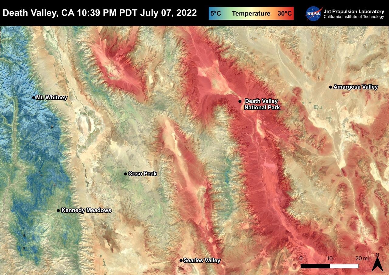
Death Valley, California is a desert valley in the Northern Mojave Desert. During the summer months, Death Valley can become one of the hottest places on Earth. Death Valley is about 85 miles from Mt. Whitney, the highest point in the contiguous United States with an elevation of 14,505 ft. This Land Surface Temperature image captured by ECOSTRESS on July 07, 2022 shows temperatures exceeding 90 degrees Fahrenheit in Death Valley and temperatures below 40 degrees Fahrenheit in the Sierra Nevada Mountain Range. ECOSTRESS is a thermal instrument on the International Space Station that measures the temperature of the ground, which is hotter than the air temperature during the day. It was launched to the space station in 2018. Its primary mission is to identify critical thresholds of water use and water stress in plants and to detect the timing, location, and predictive factors leading to plant water uptake decline and/or cessation. The nature of the high-resolution data provided by ECOSTRESS allows it to record heat related phenomena such as heat waves and wildfires. https://photojournal.jpl.nasa.gov/catalog/PIA25482
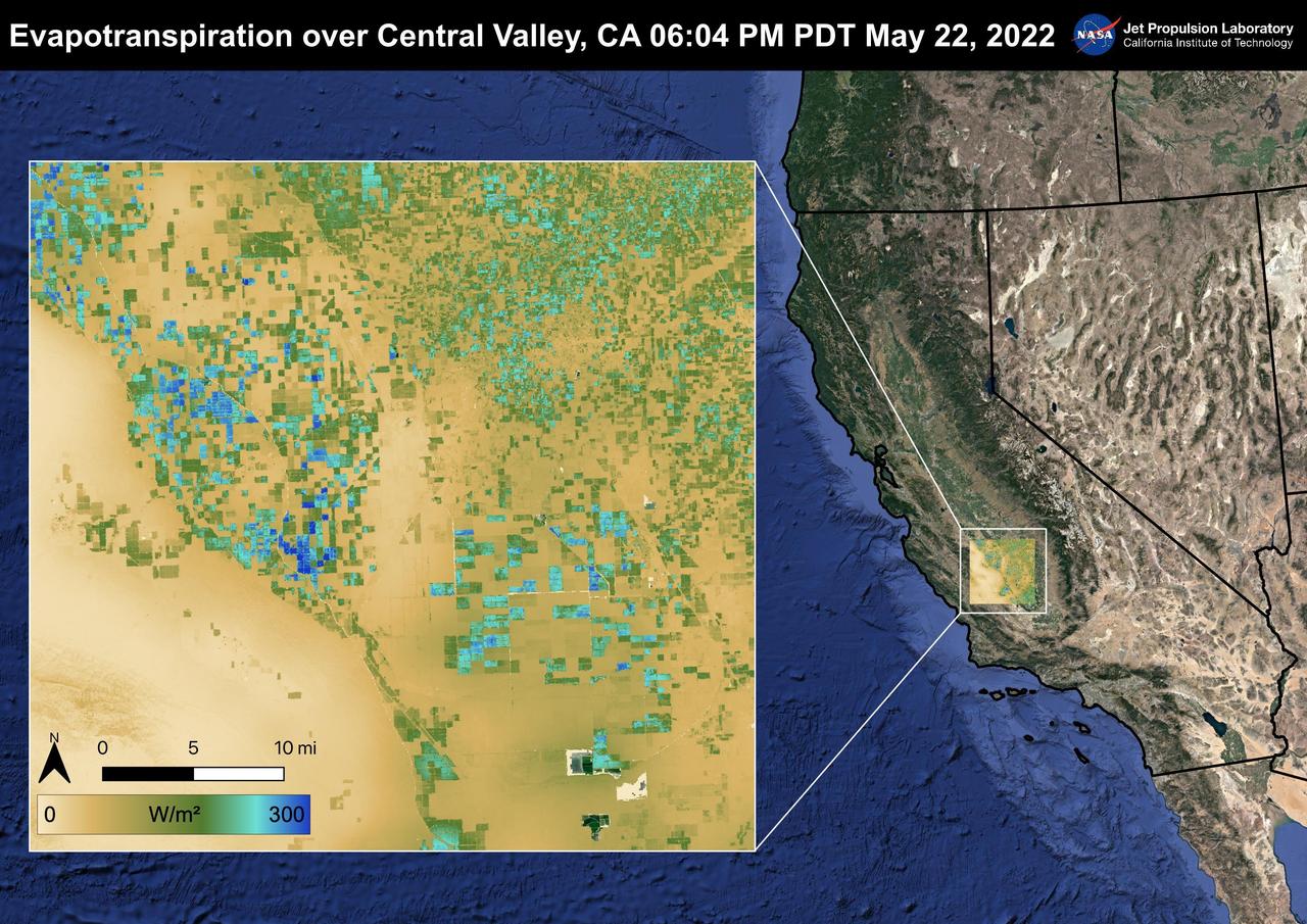
The Central Valley, CA is one of the most productive agricultural regions in the United States and the world. As California is in a continuing drought, it is important to monitor agricultural plant life to ensure maximized productivity. ECOSTRESS has the ability to monitor Evapotranspiration over agricultural fields. This Evapotranspiration image was captured by ECOSTRESS on May 22, 2022 at 06:04 PM PDT. Blue indicates high water use while brown indicates dry conditions. ECOSTRESS is a thermal instrument on the International Space Station that measures the temperature of the ground, which is hotter than the air temperature during the day. It was launched to the space station in 2018. Its primary mission is to identify critical thresholds of water use and water stress in plants and to detect the timing, location, and predictive factors leading to plant water uptake decline and/or cessation. The nature of the high-resolution data provided by ECOSTRESS allows it to record heat related phenomena such as heat waves and wildfires. https://photojournal.jpl.nasa.gov/catalog/PIA25488

On September 19, 2021 volcanic activity permanently altered the coastline of the small island of La Palma, located off the coast of northwestern Africa. Within seven hours of the initial eruption, the lava flow traveled about 6km to the Atlantic Coast where it continues to extend the coastline out into the ocean. This image taken by the ECOSTRESS module aboard the International Space Station captured the initial Laval flow several hours after the eruption. Dark spots along the coastline represent locations where lava flowed into the ocean, increasing the surface temperature. ECOSTRESS's primary mission is to detect small changes in the temperature of plants to measure evapotranspiration rates. It can use the same instrumentation to detect changes in surface temperature associated with events such as volcanic eruptions. ECOSTRESS observations have a spatial resolution of about 70x70 meters, which enables researchers to study surface-temperature conditions down to the size of a football field. The mission can acquire images of the same region at different times of the day. This is advantageous when monitoring plant stress in the same area throughout the day, for example. https://photojournal.jpl.nasa.gov/catalog/PIA24916
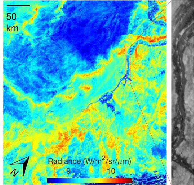
ECOSTRESS acquired this image the night of July 9, 2018, over Egypt. Yellow and red indicate generally higher temperatures. The River Nile is visible as a thin blue line on the main image. The black-and-white inset shows the level of detail available from ECOSTRESS, with the relatively cool Nile River and surrounding vegetation appearing darker. https://photojournal.jpl.nasa.gov/catalog/PIA22590
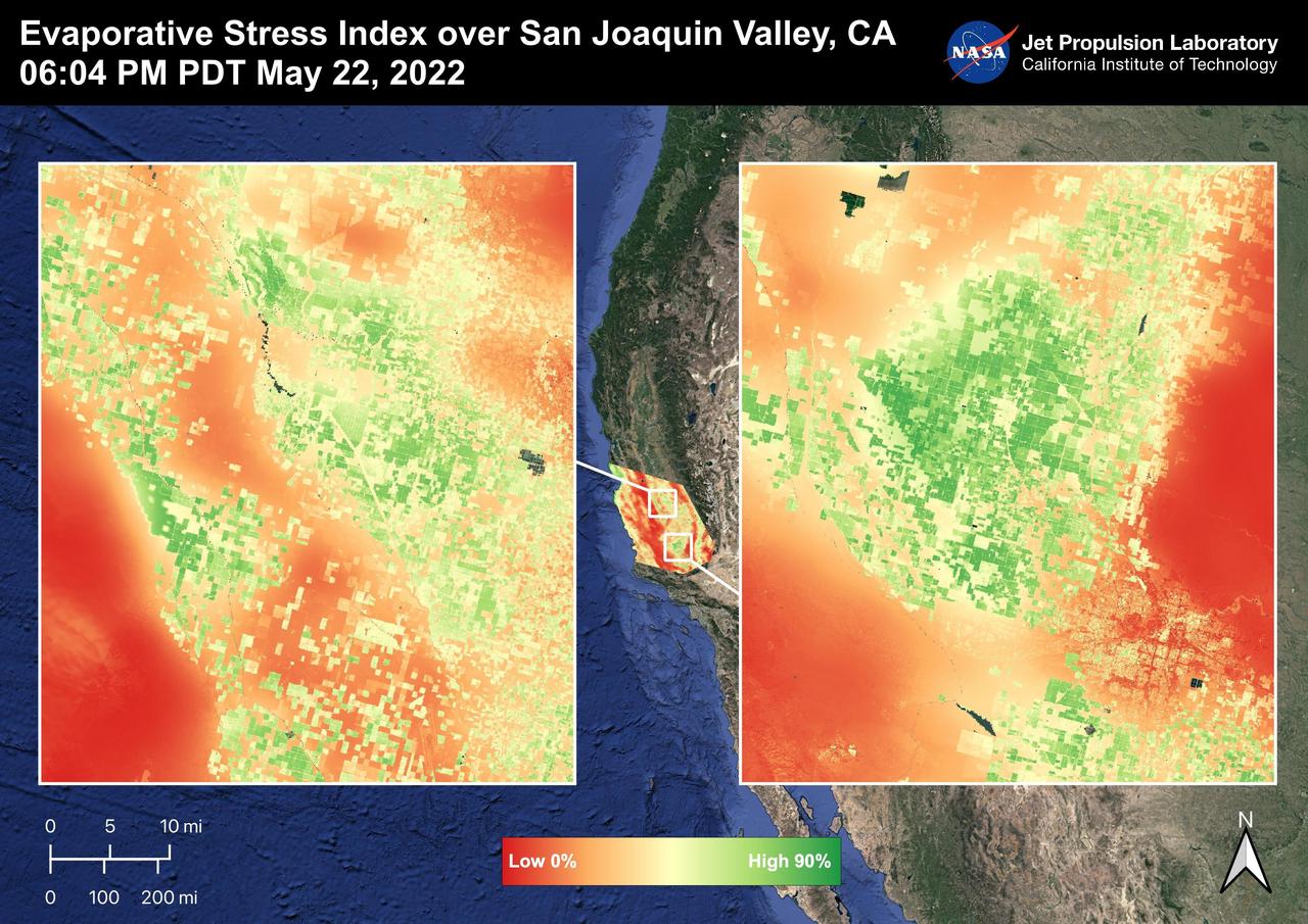
The San Joaquin Valley, CA is one of the most productive agricultural regions in the United States and the world. The image shows the Evaporative Stress Index over the San Joaquin Valley on May 22, 2022 at 06:04 PM PDT where many fields show high ESI values that indicate low plant stress whereas low ESI values indicate high plant stress. ECOSTRESS's ability to detect Evaporative Stress over the agricultural fields can help farmers and decision makers in their choices. As California is in a continuing drought, it is important to monitor that agricultural plant life. ECOSTRESS is a thermal instrument on the International Space Station that measures the temperature of the ground, which is hotter than the air temperature during the day. It was launched to the space station in 2018. Its primary mission is to identify critical thresholds of water use and water stress in plants and to detect the timing, location, and predictive factors leading to plant water uptake decline and/or cessation. The nature of the high-resolution data provided by ECOSTRESS allows it to record heat related phenomena such as heat waves and wildfires. https://photojournal.jpl.nasa.gov/catalog/PIA25487
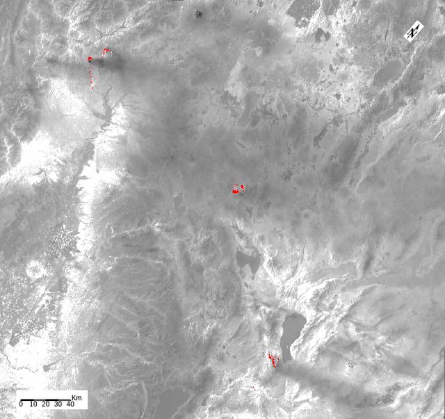
ECOSTRESS, NASA's new Earth-observing mission aboard the International Space Station, detected three wildfires burning in the western US on July 28, 2018 -- the Carr and Whaleback fires in California, and the Perry Fire in Nevada. The fires can be seen in red in Figures 1 and 2. Zooming in on the two larger fires shows the heat data in more detail and also reveals the fires' thick smoke plumes. ECOSTRESS launched on June 29 as part of a SpaceX commercial resupply mission to the space station. Its primary mission is to measure surface temperatures to detect plant health; however, it can also detect other heat-related phenomenon like heat waves, volcanoes and wildfires. This is the first image of wildfires acquired from ECOSTRESS. https://photojournal.jpl.nasa.gov/catalog/PIA22490
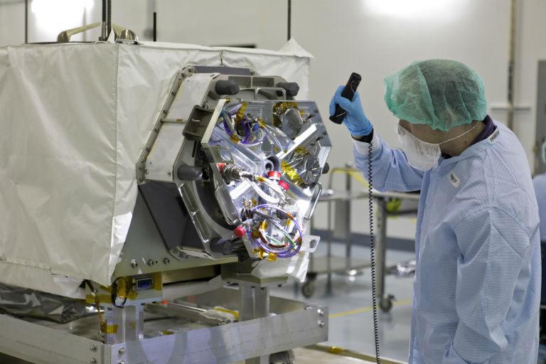
A technician inspects NASA's ECOSTRESS instrument in a clean room at Kennedy Space Center in Florida. ECOSTRESS measures the temperature of plants, which shows how they are regulating their water use in response to heat stress. https://photojournal.jpl.nasa.gov/catalog/PIA22509
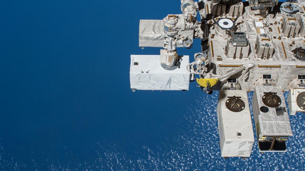
iss056e078527 (7/6/2018) --- Photographic documentation of ECOSTRESS installation onto the Japanese Experiment Module - Exposed Facility (JEM-EF). The ECOsystem Spaceborne Thermal Radiometer Experiment on Space Station (ECOSTRESS) investigation provides the first-ever high spatiotemporal (space-time) resolution thermal infrared measurements of the surface of the Earth from the International Space Station (ISS).
ECOSTRESS Unbagging
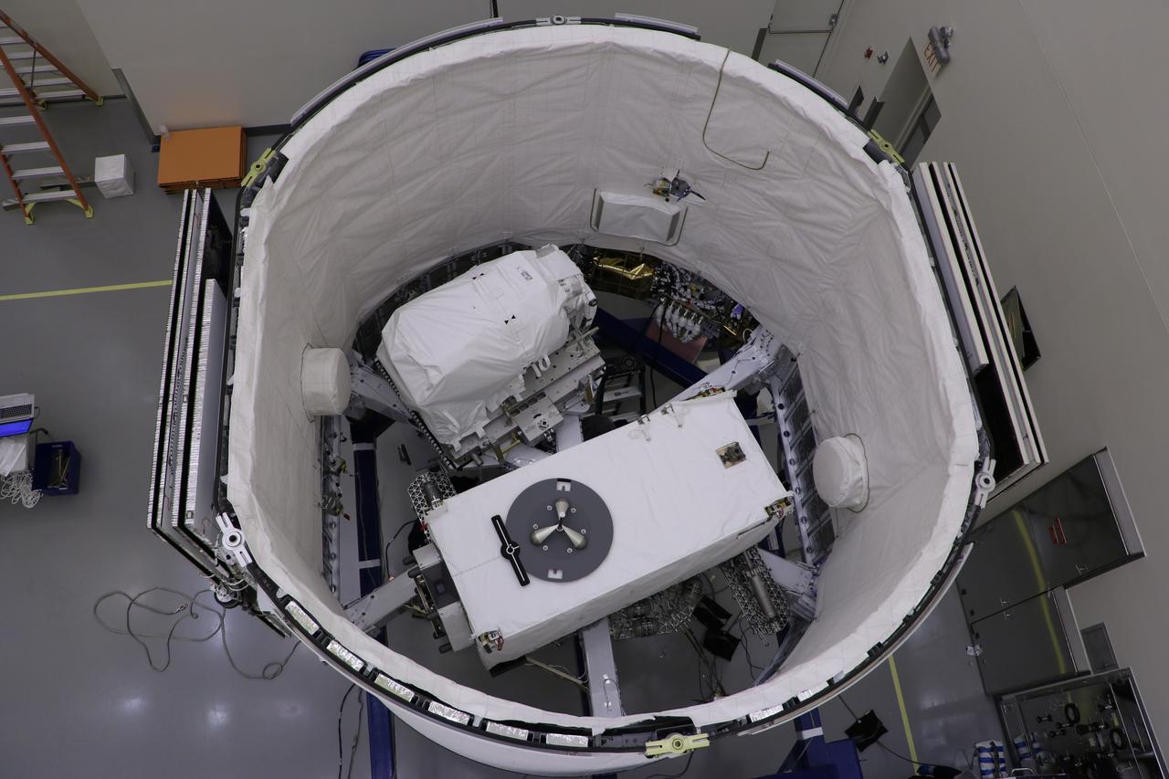
The ECOsystem Spaceborne Thermal Radiometer Experiment on Space Station (ECOSTRESS), pictured at the bottom, and the Latching End Effector (LEE), pictured at the top, are integrated into the unpressurized SpaceX Dragon truck June 2, 2018, at the SpaceX facility on Cape Canaveral Air Force Station in Florida. The payloads will be carried to the International Space Station on SpaceX's 15th Commercial Resupply Services mission. ECOSTRESS will measure the temperature of plants and use that information to better understand how much water plants need and how they respond to stress. The Canadian Space Agency is supplying LEE for the Canadarm2 as a spare to replace a failed unit removed by astronauts during a spacewalk in 2017. Each end of the Canadarm2 robotic arm has an identical LEE, which acts like a "hand" to grapple payloads and visiting cargo spaceships.
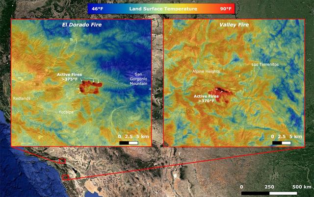
On Sept. 6, NASA's ECOsystem Spaceborne Thermal Radiometer Experiment on Space Station (ECOSTRESS) imaged active fires across California, including the El Dorado fire near Yucaipa and the Valley fire in Japatul Valley in the southern part of the state. As of Sept. 8, there were 25 major wildfires burning in California. Both images, taken at 12:13 a.m. PDT (3:13 a.m. EDT), show multiple concentrated areas of surface temperatures (in red) higher than 375 degrees Fahrenheit (191 degrees Celsius). These high temperature regions were likely where the active fires were occurring. The surrounding areas show abnormally warm middle-of-the-night background surface temperatures (orange) due to the ongoing heat wave. https://photojournal.jpl.nasa.gov/catalog/PIA23788
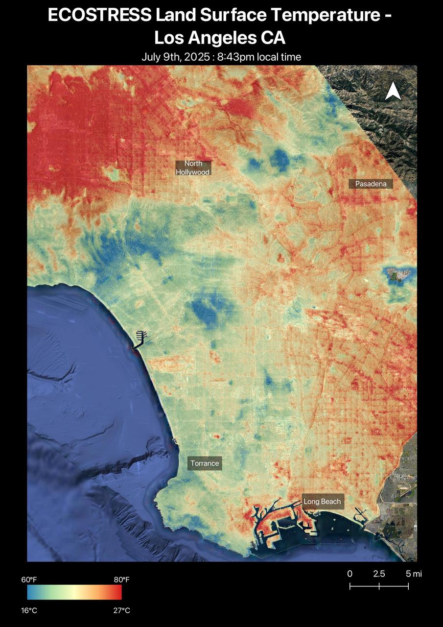
A short-lived heat wave that hit the Los Angeles area the week of July 7, 2025, was the first of summer. The heat lingered into the evening hours, as captured by NASA's Ecosystem Spaceborne Thermal Radiometer Experiment on Space Station (ECOSTRESS) instrument. By nearly 8:45 p.m. local time July 9, surface temperatures in the San Fernando Valley were still over 80 degrees Fahrenheit (27 degrees Celsius). The ECOSTRESS sensor recorded similar temperatures for downtown Pasadena (Figure A) and parts of Altadena, east of NASA's Jet Propulsion Laboratory, which manages the mission. In these data visualizations, dark red indicates higher temperatures, while areas in blue and green are cooler. Coastal regions remained significantly cooler than inland areas. The ECOSTRESS instrument measures thermal infrared emissions from Earth's surface. This enables researchers to monitor plant health, the progress of wildfires, land surface temperatures, and the burn risk to people from hot surfaces such as asphalt. Land surface temperatures are hotter than air temperatures during the day. Air temperatures, which are measured out of direct sunlight, are usually what meteorologists report in a weather forecast. https://photojournal.jpl.nasa.gov/catalog/PIA26651
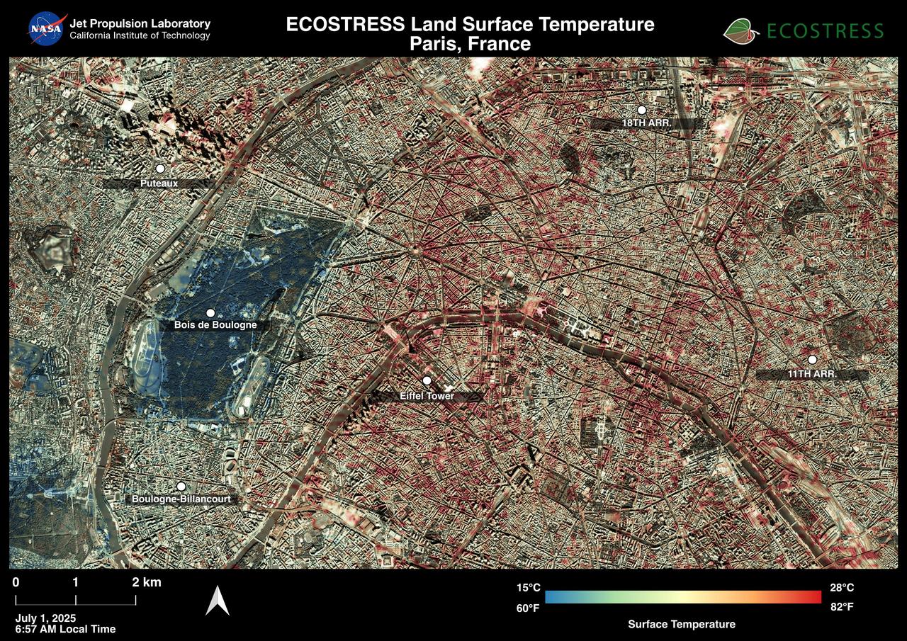
Paris was one of many European cities hit by a record-breaking heat wave at the end of June and early July 2025. NASA's Ecosystem Spaceborne Thermal Radiometer Experiment on Space Station (ECOSTRESS) instrument recorded surface temperatures of 82 degrees Fahrenheit (23 degrees Celsius) at 6:57 a.m. local time on July 1. Extreme daytime air temperatures – of over 100 degrees F (38 degrees C) – prompted officials to close the summit of the Eiffel Tower on July 1 and 2. In this visualization of ECOSTRESS data, dark red indicates higher temperatures while green and blue are cooler. The city is peppered with areas of several blocks where surface temperatures reached more than 80 F (27 C), including around the Eiffel Tower, before 7 a.m. The ECOSTRESS instrument measures thermal infrared emissions from Earth's surface. This enables researchers to monitor plant health, the progress of wildfires, land surface temperatures, and the burn risk to people from hot surfaces such as asphalt. Land surface temperatures are hotter than air temperatures during the day. Air temperatures, which are measured out of direct sunlight, are usually what meteorologists report in a weather forecast. https://photojournal.jpl.nasa.gov/catalog/PIA26190
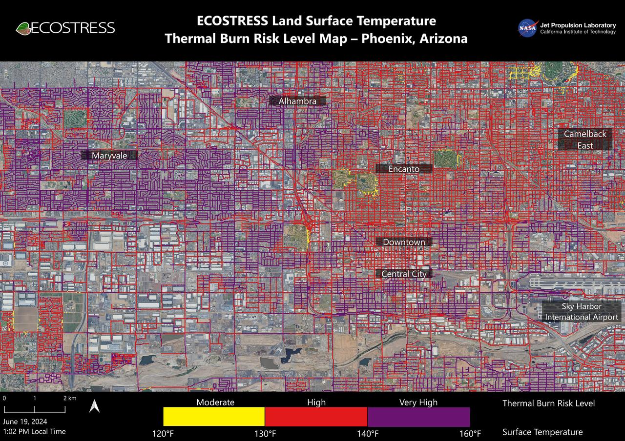
Data from NASA's ECOSTRESS (Ecosystem Spaceborne Thermal Radiometer Experiment on Space Station) instrument was used to map scorching pavement in Phoenix where contact with skin can cause serious burns. Based on measurements captured at 1:02 p.m. local time on June 19, 2024, the image shows land surface temperatures across a grid of roads and adjacent sidewalks, revealing how urban spaces can turn hazardous during hot weather. The Arizona city's miles of asphalt and concrete surfaces (colored here in yellow, red, and purple, based on temperature) trap heat, as the image indicates. The surfaces registered at least 120 degrees Fahrenheit (49 degrees Celsius) to the touch – hot enough to cause contact burns in minutes to seconds. At the lower right of the image is Phoenix Sky Harbor International Airport, where ECOSTRESS recorded some of the hottest land surface temperatures within the city – around 140 F (60 C). The air temperature on June 19 at the airport reached 106 F (43 C). Air temperature, which is measured out of direct sunlight, can differ significantly from the temperature at the land surface. Streets are often the hottest surfaces of the built environment due to dark asphalt paving that absorbs more sunlight than lighter-colored surfaces; asphalt absorbs up to 95% of solar radiation. These types of surfaces can easily be 40 to 60 degrees F (22 to 33 degrees C) hotter than the air temperature on a very hot day. Launched to the International Space Station in 2018, ECOSTRESS measures temperatures at the highest spatial resolution of any space-based instrument, producing images with a typical pixel size of about 225 feet (70 meters) by 125 feet (38 meters). The image of Phoenix was produced at higher spatial resolution using a machine learning algorithm that incorporates data from additional satellites: NASA/USGS Landsat and Sentinel-2. The combined measurements were used to "sharpen" the surface temperatures to a resolution of 100 feet (30 meters) by 100 feet (30 meters). https://photojournal.jpl.nasa.gov/catalog/PIA25529