
Lake Ilopango is a crater lake which fills a volcanic caldera in central El Salvador, immediately east of the capital city San Salvador. The caldera collapsed most recently in about 500 AD, producing 20 times as much ash as the Mount St. Helens eruption, and blanketing an area of at least 10,000 square kilometers waist-deep in ash. The only historical eruption occurred in 1879, forming lava domes, now islets in the lake. Quetzaltepec is the stratovolcano just west of the city. Its last eruption in 1917 produced lavas flowing down the northwest flank, and evaporated the crater lake. The image was acquired March 5, 2006, covers an area of 27 by 42 km, and is located at 13.7 degrees north, 89.1 degrees west. http://photojournal.jpl.nasa.gov/catalog/PIA19237
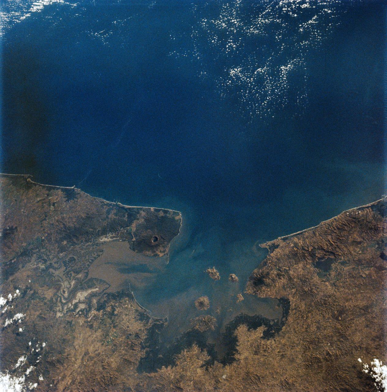
AS09-19-3019 (3-13 March 1969) --- Gulf of Fonseca, on the Pacific coast of Central America, as photographed from the Apollo 9 spacecraft during its Earth-orbital mission. The gulf is shared by the nations of El Salvador, Honduras, and Nicaragua. The prominent volcano on the peninsula in Nicaragua is Volcan Cosiguina.
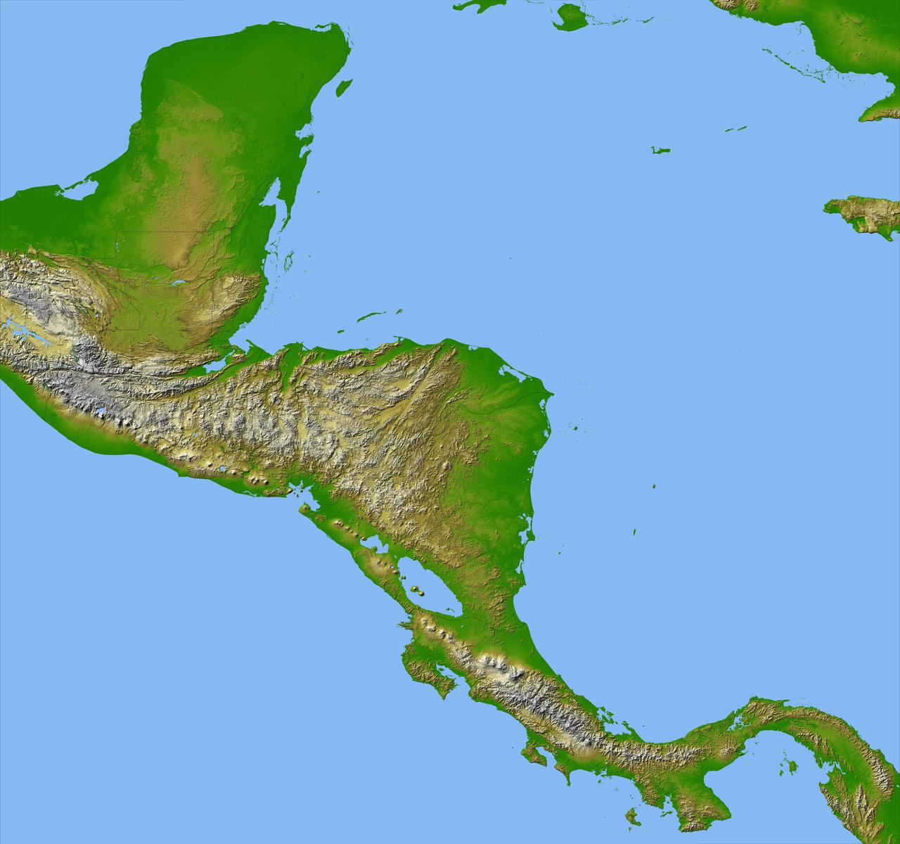
Panama, Costa Rica, Nicaragua, El Salvador, Honduras, Guatemala, Belize, southern Mexico and parts of Cuba and Jamaica are all seen in this image from NASA Shuttle Radar Topography Mission.
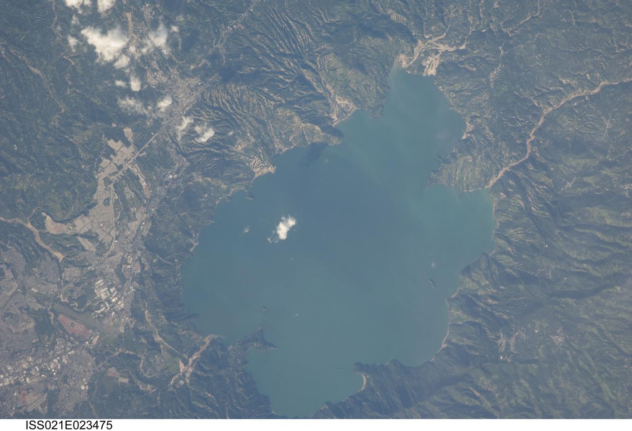
ISS021-E-023475 (11 Nov. 2009) --- Lake Ilopango, El Salvador is featured in this image photographed by an Expedition 21 crew member on the International Space Station. The Central American country of El Salvador occupies a land area nearly the same as the US State of Massachusetts, and includes numerous historically active volcanoes. This detailed photograph highlights the Ilopango Caldera that is located approximately 16 kilometers to the east of the capital city of San Salvador. Calderas are the geologic record of powerful volcanic eruptions that empty out a volcano?s magma chamber ? following the eruption, the overlying volcanic structure collapses into the newly-formed void, leaving a large crater-like feature (the caldera). The last caldera-forming eruption at Ilopango occurred during the 5th century AD; it was a powerful event that produced pyroclastic flows that destroyed early Mayan cities in the region. Later volcanic activity included the formation of several lava domes within the lake-filled caldera and near the shoreline. The only historical eruption at Ilopango took place in 1879-80. This activity resulted in the formation of a lava dome in the center of Lake Ilopango, the summit of which forms small islets today known as Islas Quemadas. The city of Ilopango borders the lake to the west (left) while green vegetated hillslopes ring the rest of the shoreline. White patchy cumulus clouds are also visible in the image (center and upper left).
iss070e098305 (Feb. 23, 2023) --- This waterway, comprised of the Bahía de La Unión, Bahía de Chismuyo, Bahía de San Lorenzo, and the Gulf of Fonseca, is surrounded by the Latin American nations of El Salvador, Honduras, and Nicaragua. The International Space Station was orbiting off the coast of Nicaragua and 259 miles above the Pacific Ocean at the time of the photograph.
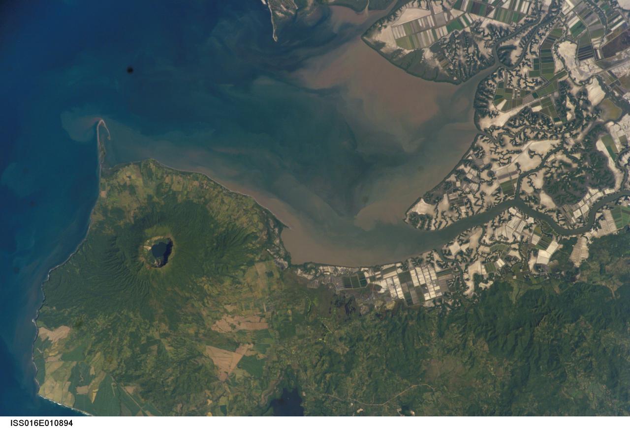
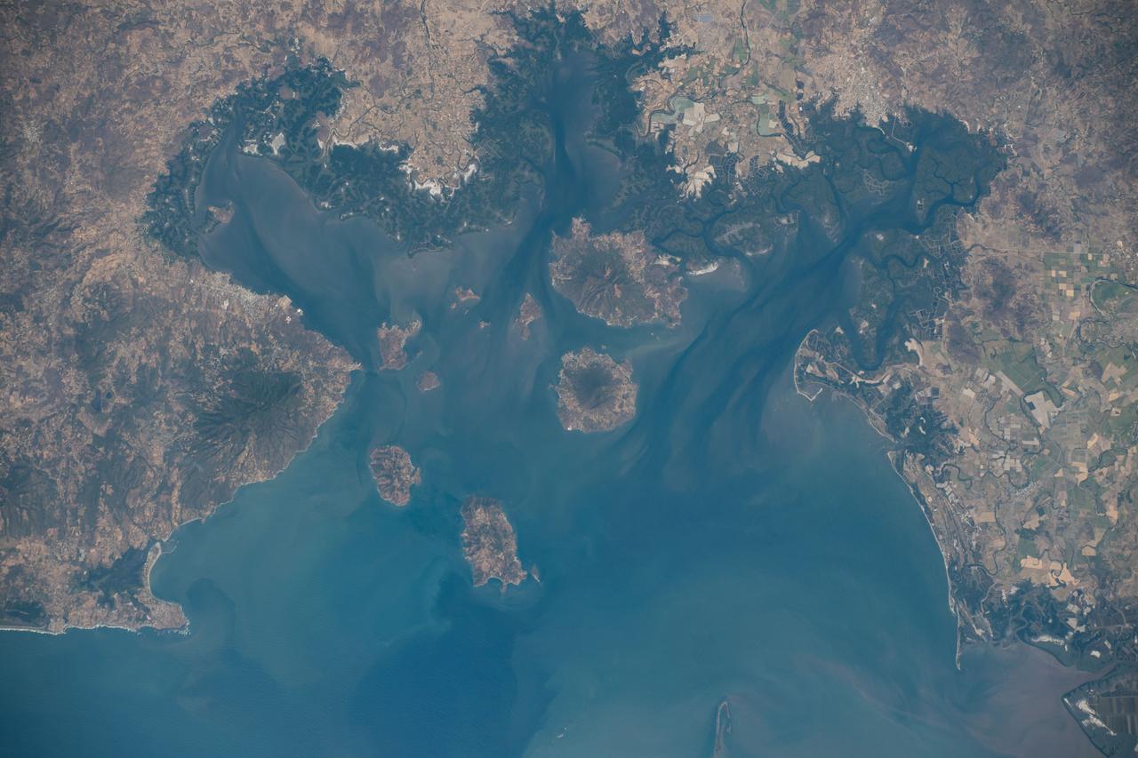
ISS016-E-010894 (17 Nov. 2007) --- Cosiguina Volcano, Nicaragua is featured in this image photographed by an Expedition 16 crewmember on the International Space Station. Three Central American countries (El Salvador, Honduras, and Nicaragua) include coastline along the Gulf of Fonseca that opens into the Pacific Ocean. The southern boundary of the Gulf is a peninsula formed by the Cosiguina volcano illustrated in this view. Cosiguina is a stratovolcano, typically tall cone-shaped structures formed by alternating layers of solidified lava and volcanic rocks (ash, pyroclastic flows, breccias) produced by explosive eruptions. The summit crater is filled with a lake (Laguna Cosiguina). The volcano last erupted in 1859, but its most famous activity occurred in 1835 when it produced the largest historical eruption in Nicaragua. Ash from the 1835 eruption has been found in Mexico, Costa Rica, and Jamaica. The volcano has been quiet since 1859, only an instant in terms of geological time. An earthquake swarm was measured near Cosiguina in 2002, indicating that tectonic forces are still active in the region although the volcano is somewhat isolated from the line of more recently active Central American volcanoes to the northwest and southeast. Intermittently observed gas bubbles in Laguna Cosiguina, and a hot spring along the eastern flank of the volcano are the only indicators of hydrothermal activity at the volcano. The fairly uniform vegetation cover (green) on the volcano's sides also attest to a general lack of gas emissions or "hot spots" on the 872 meter high cone, according to NASA scientists who study the photos downlinked from the orbital outpost.