
VANDENBERG AFB, Calif. -- The air field at Vandenberg Air Force Base in California. Vandenberg Air Force Base has a mission of placing satellites into polar orbit from the West Coast, using expendable boosters such as the Pegasus, Taurus, Minotaur, Atlas V and Delta IV. Photo credit: NASA_Cory Huston
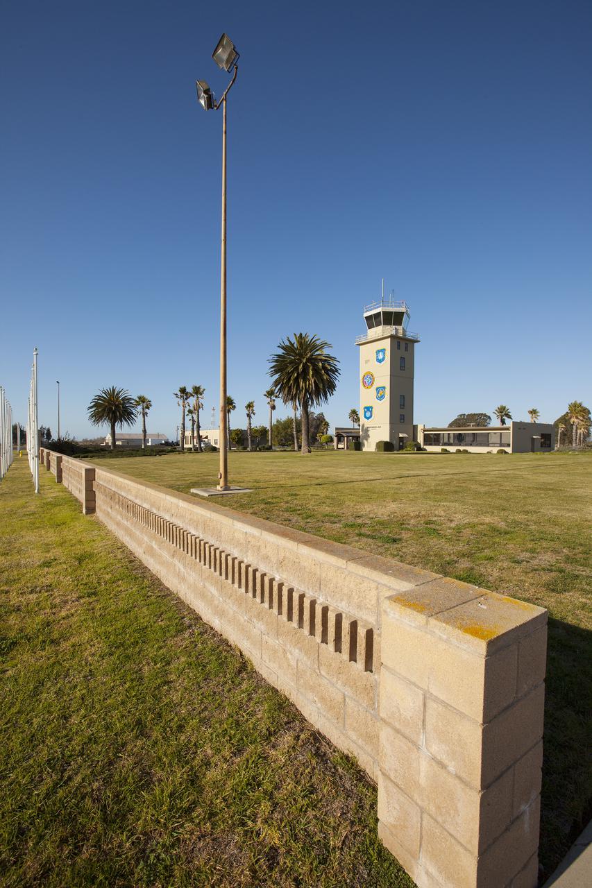
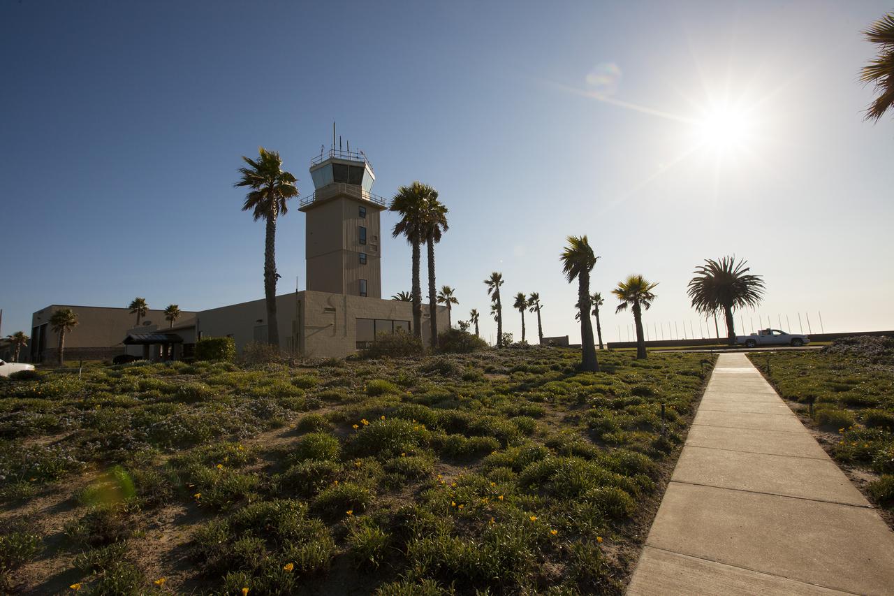
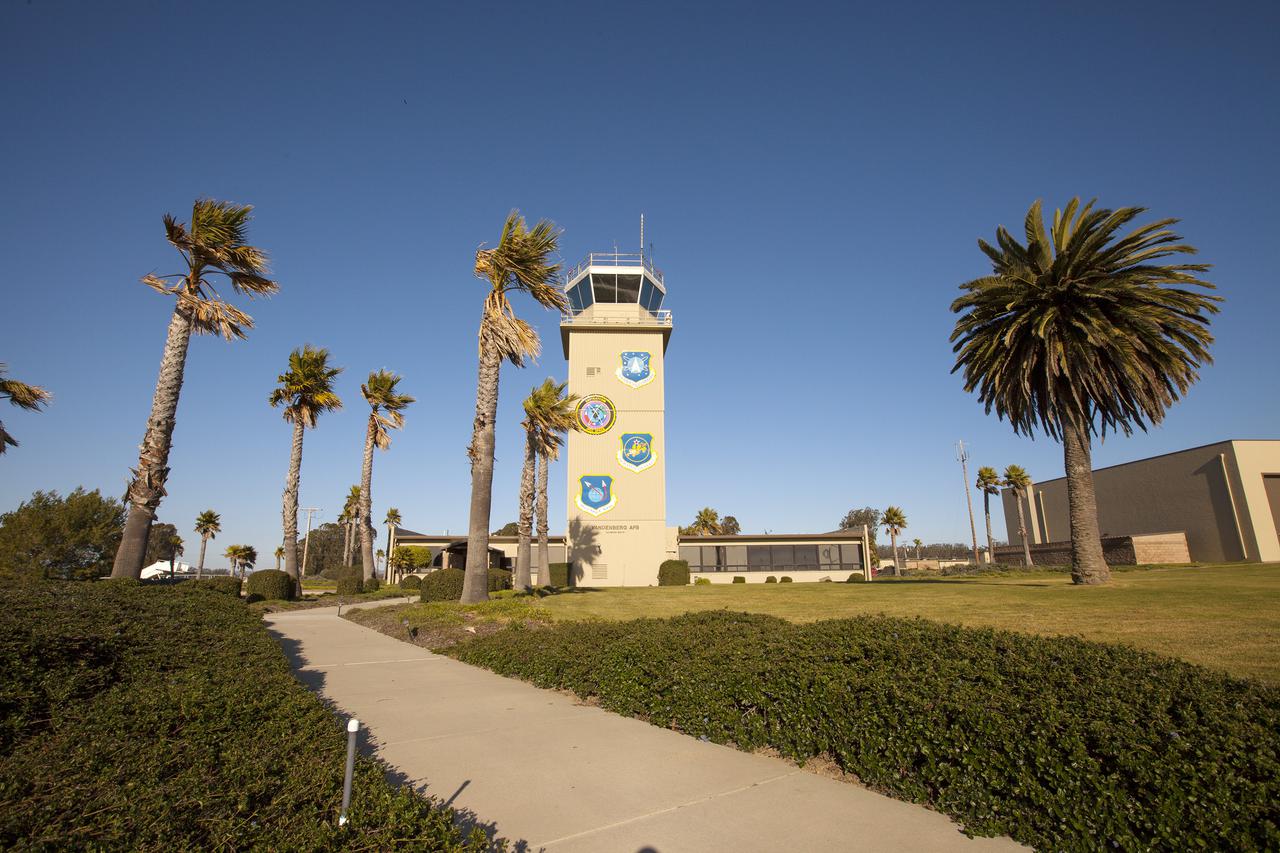
VANDENBERG AFB, Calif. -- The air traffic control tower for the 30th Space Wing air field at Vandenberg Air Force Base in California. Vandenberg Air Force Base has a mission of placing satellites into polar orbit from the West Coast, using expendable boosters such as the Pegasus, Taurus, Minotaur, Atlas V and Delta IV. Photo credit: NASA_Cory Huston
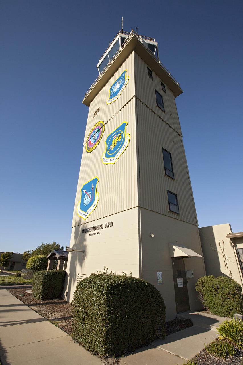
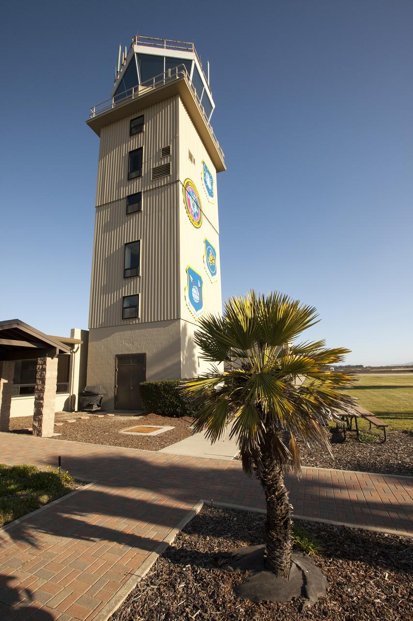
VANDENBERG AFB, Calif. -- The air traffic control tower for the 30th Space Wing air field at Vandenberg Air Force Base in California. Vandenberg Air Force Base has a mission of placing satellites into polar orbit from the West Coast, using expendable boosters such as the Pegasus, Taurus, Minotaur, Atlas V and Delta IV. Photo credit: NASA_Cory Huston
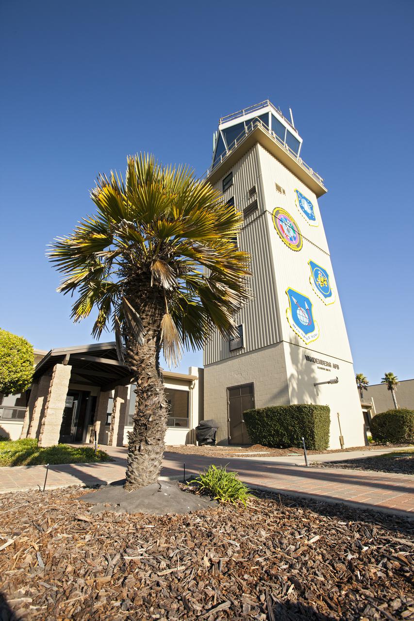
VANDENBERG AFB, Calif. -- The air traffic control tower for the 30th Space Wing air field at Vandenberg Air Force Base in California. Vandenberg Air Force Base has a mission of placing satellites into polar orbit from the West Coast, using expendable boosters such as the Pegasus, Taurus, Minotaur, Atlas V and Delta IV. Photo credit: NASA_Cory Huston
VANDENBERG AFB, Calif. -- The air traffic control tower for the 30th Space Wing air field at Vandenberg Air Force Base in California. Vandenberg Air Force Base has a mission of placing satellites into polar orbit from the West Coast, using expendable boosters such as the Pegasus, Taurus, Minotaur, Atlas V and Delta IV. Photo credit: NASA_Cory Huston
VANDENBERG AFB, Calif. -- The air traffic control tower for the 30th Space Wing air field at Vandenberg Air Force Base in California. Vandenberg Air Force Base has a mission of placing satellites into polar orbit from the West Coast, using expendable boosters such as the Pegasus, Taurus, Minotaur, Atlas V and Delta IV. Photo credit: NASA_Cory Huston
VANDENBERG AFB, Calif. -- The air traffic control tower for the 30th Space Wing air field at Vandenberg Air Force Base in California. Vandenberg Air Force Base has a mission of placing satellites into polar orbit from the West Coast, using expendable boosters such as the Pegasus, Taurus, Minotaur, Atlas V and Delta IV. Photo credit: NASA_Cory Huston

VANDENBERG AFB, Calif. -- The air traffic control tower for the 30th Space Wing air field at Vandenberg Air Force Base in California. Vandenberg Air Force Base has a mission of placing satellites into polar orbit from the West Coast, using expendable boosters such as the Pegasus, Taurus, Minotaur, Atlas V and Delta IV. Photo credit: NASA_Cory Huston
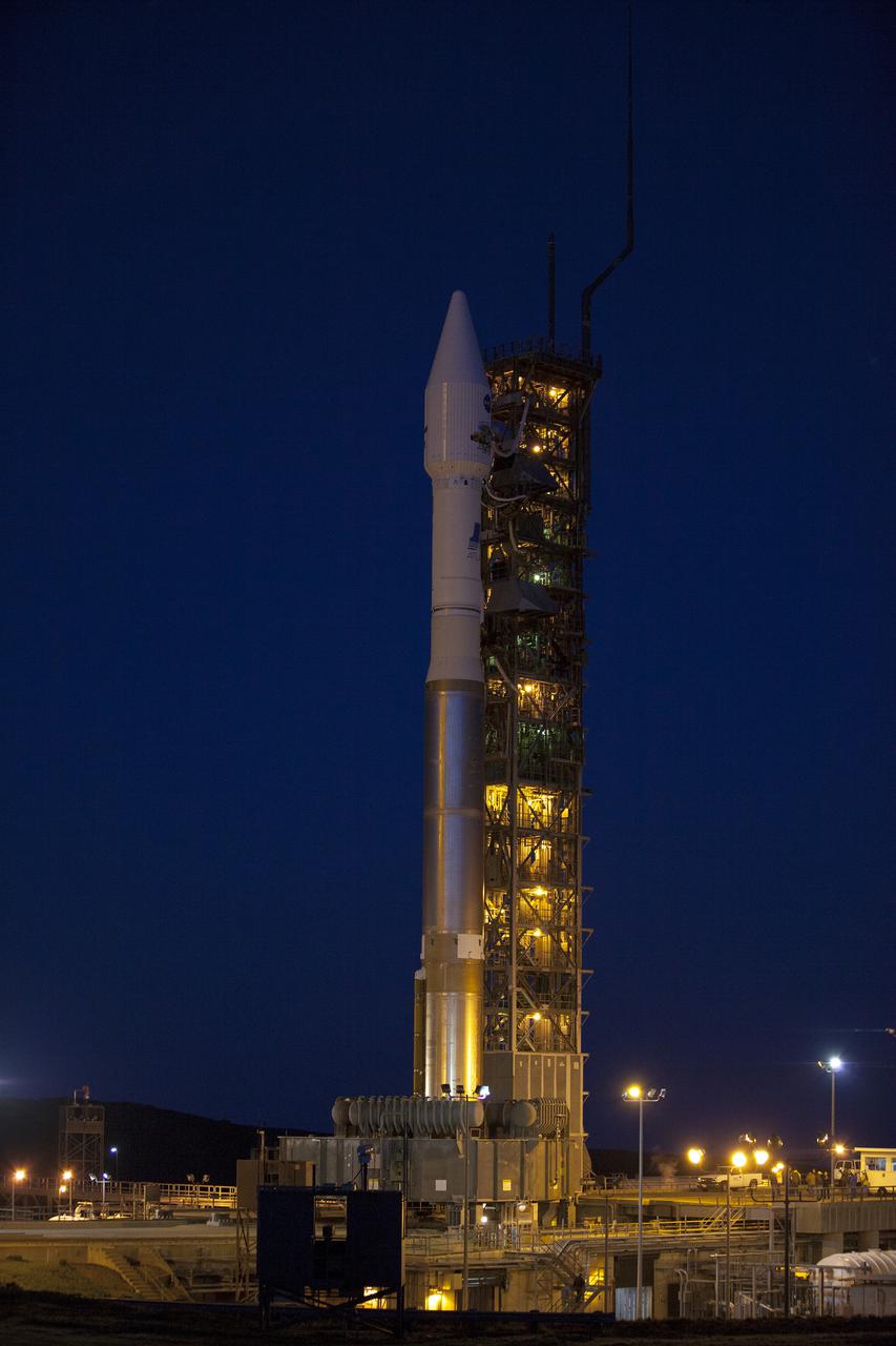
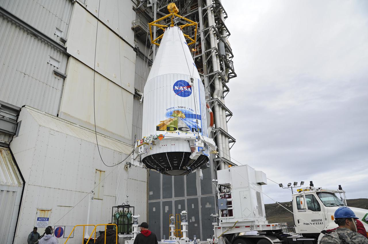
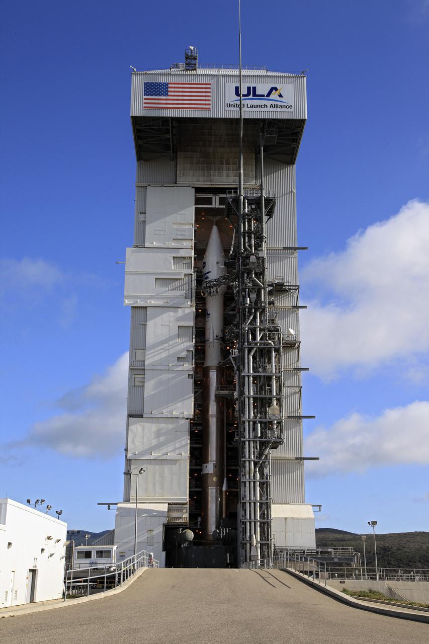
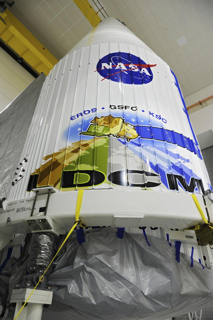
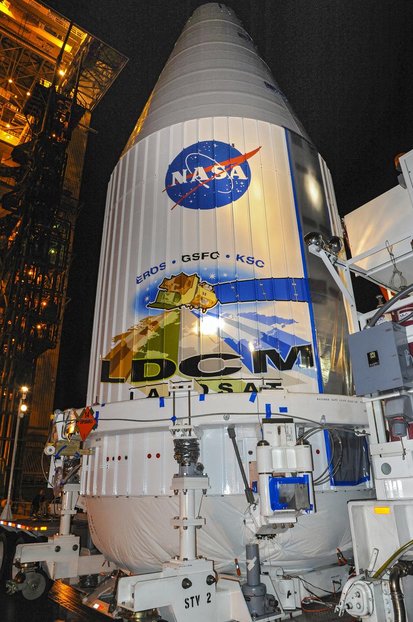
VANDENBERG AFB, Calif. -- At Vandenberg Air Force Base, Calif., NASA's Landsat Data Continuity Mission, or LDCM, satellite is mounted atop a United Launch Alliance Atlas V rocket poised for launch at Space Launch Complex 3E. The Landsat Data Continuity Mission LDCM is the future of Landsat satellites. It will continue to obtain valuable data and imagery to be used in agriculture, education, business, science, and government. The Landsat Program provides repetitive acquisition of high resolution multispectral data of the Earth's surface on a global basis. The data from the Landsat spacecraft constitute the longest record of the Earth's continental surfaces as seen from space. It is a record unmatched in quality, detail, coverage, and value. Liftoff is planned for Feb. 11, 2013 aboard a United Launch Alliance Atlas V rocket. For more information, visit: http:__www.nasa.gov_mission_pages_landsat_main_index.html Photo credit: NASA_Kim Shiflett
CAPE CANAVERAL, Fla. – The United Launch Alliance Atlas V rocket lifts off from Space Launch Complex 41 at Cape Canaveral Air Force Station carrying NASA's Tracking and Data Relay Satellite, or TDRS-L, spacecraft to Earth orbit. Liftoff was at 9:33 p.m. EST. The TDRS-L spacecraft is the second of three new satellites designed to ensure vital operational continuity for NASA by expanding the lifespan of the Tracking and Data Relay Satellite System TDRSS fleet, which consists of eight satellites in geosynchronous orbit. The spacecraft provide tracking, telemetry, command and high bandwidth data return services for numerous science and human exploration missions orbiting Earth. These include NASA's Hubble Space Telescope and the International Space Station. TDRS-L has a high-performance solar panel designed for more spacecraft power to meet the growing S-band communications requirements. TDRSS is one of NASA Space Communication and Navigation’s SCaN three networks providing space communications to NASA’s missions. For more information more about TDRS-L, visit: http:__www.nasa.gov_tdrs To learn more about SCaN, visit: www.nasa.gov_scan Photo credit: NASA_Tony Gray and Sandy Joseph
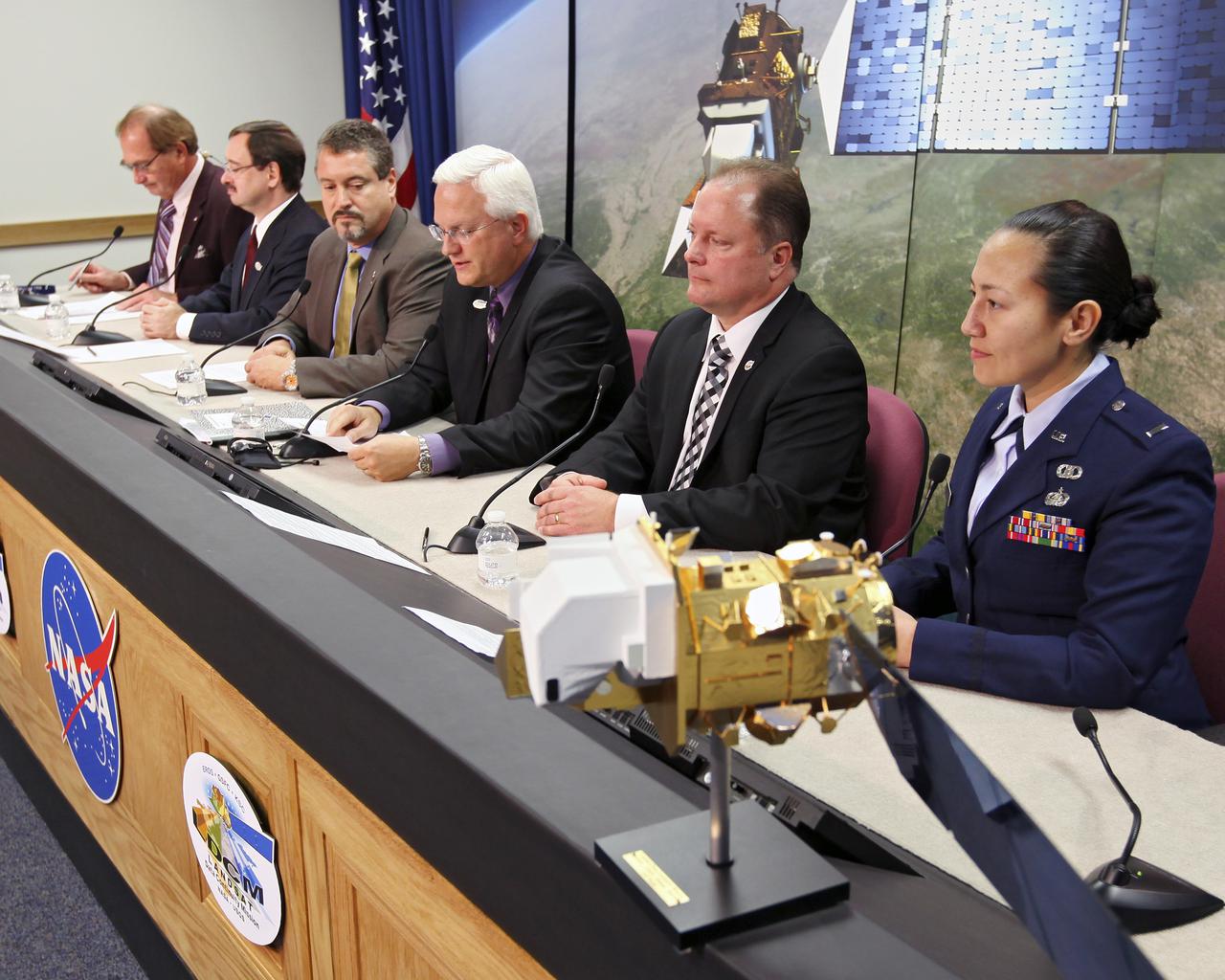
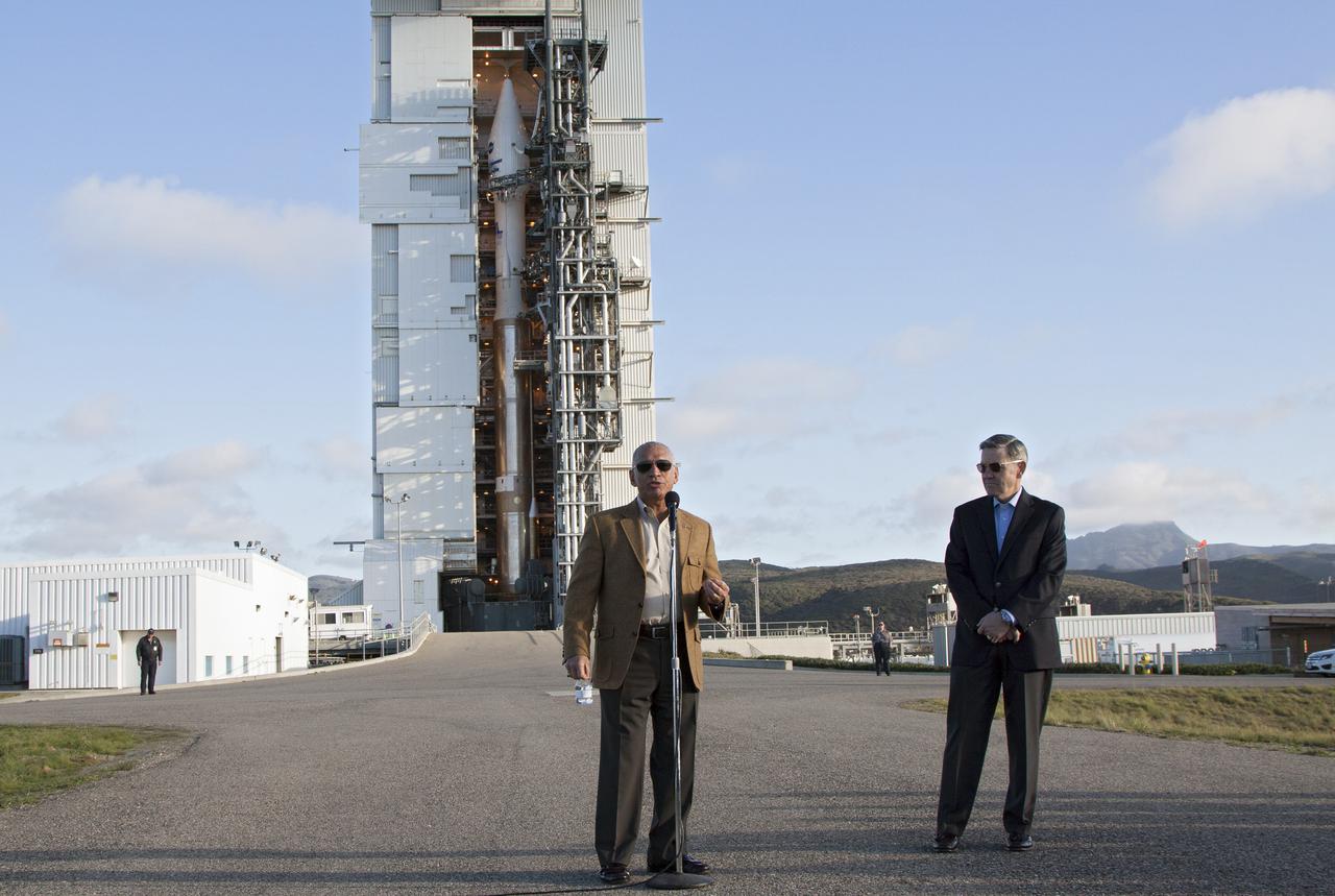
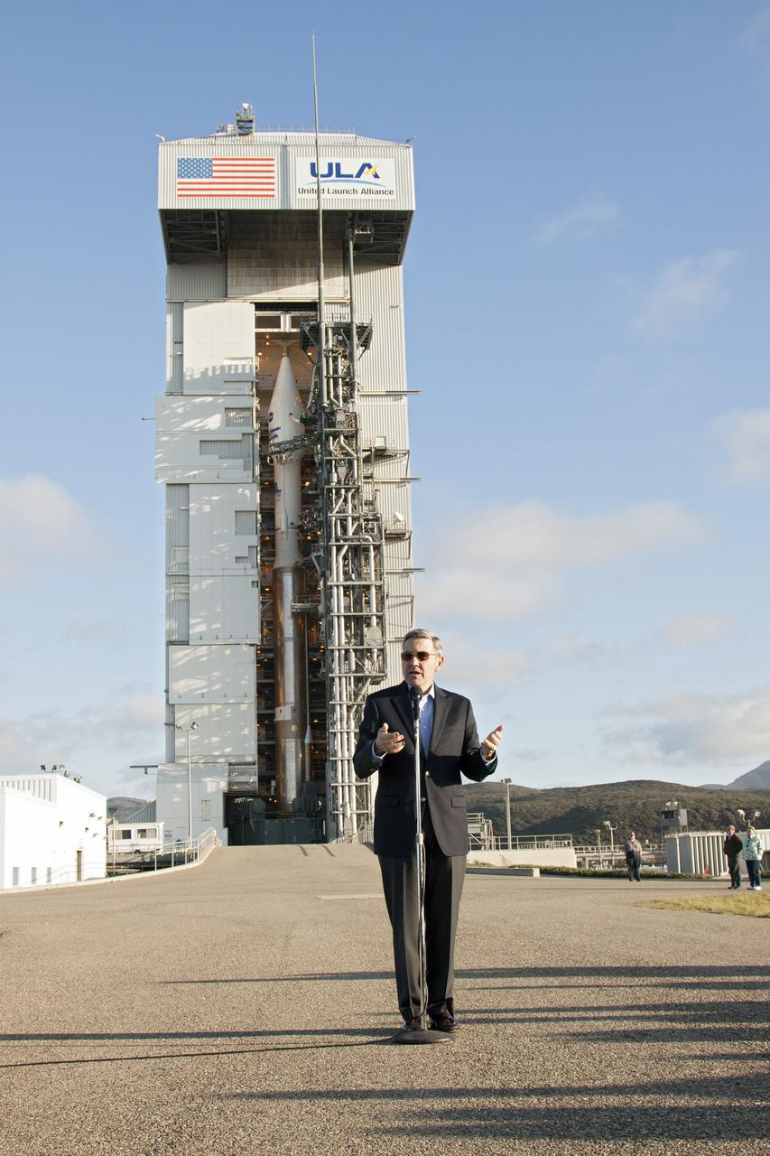
VANDENBERG AIR FORCE BASE, Calif. -- Media attend a prelaunch press conference at Vandenberg Air Force Base in California to discuss NASA's readiness to launch the Landsat Data Continuity Mission LDCM. From left are George Diller of NASA Public Affairs, LDCM program executive David Jarrett from NASA Headquarters, NASA Launch Director Omar Baez from Kennedy Space Center, United Launch Alliance Program Manager for NASA Missions Vernon Thorp, LDCM Project Manager Ken Schwer from Goddard Space Flight Center, and 1st Lt. Jennifer Kelley, launch weather officer for the 30th Operations Support Squadron at Vandenberg. The Landsat Data Continuity Mission LDCM is the future of Landsat satellites. It will continue to obtain valuable data and imagery to be used in agriculture, education, business, science, and government. The Landsat Program provides repetitive acquisition of high resolution multispectral data of the Earth's surface on a global basis. The data from the Landsat spacecraft constitute the longest record of the Earth's continental surfaces as seen from space. It is a record unmatched in quality, detail, coverage, and value. Liftoff is planned for Feb. 11, 2013 aboard a United Launch Alliance Atlas V rocket. For more information, visit: http:__www.nasa.gov_mission_pages_landsat_main_index.html Photo credit: NASA_Kim Shiflett
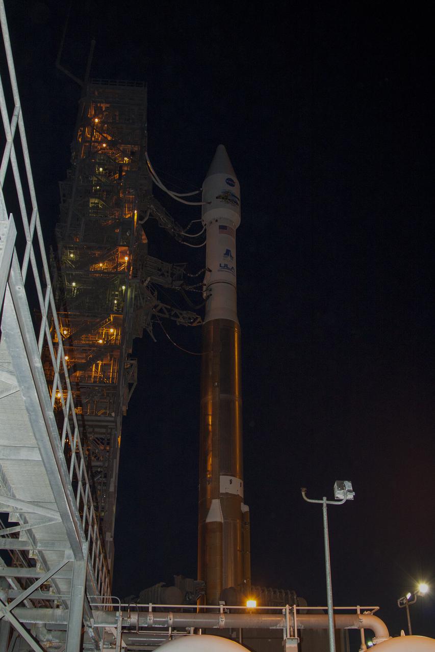
VANDENBERG AFB, Calif. -- At Vandenberg Air Force Base, Calif., NASA's Landsat Data Continuity Mission, or LDCM, satellite is mounted atop a United Launch Alliance Atlas V rocket poised for launch at Space Launch Complex 3E. The Landsat Data Continuity Mission LDCM is the future of Landsat satellites. It will continue to obtain valuable data and imagery to be used in agriculture, education, business, science, and government. The Landsat Program provides repetitive acquisition of high resolution multispectral data of the Earth's surface on a global basis. The data from the Landsat spacecraft constitute the longest record of the Earth's continental surfaces as seen from space. It is a record unmatched in quality, detail, coverage, and value. Liftoff is planned for Feb. 11, 2013 aboard a United Launch Alliance Atlas V rocket. For more information, visit: http:__www.nasa.gov_mission_pages_landsat_main_index.html Photo credit: NASA_Kim Shiflett
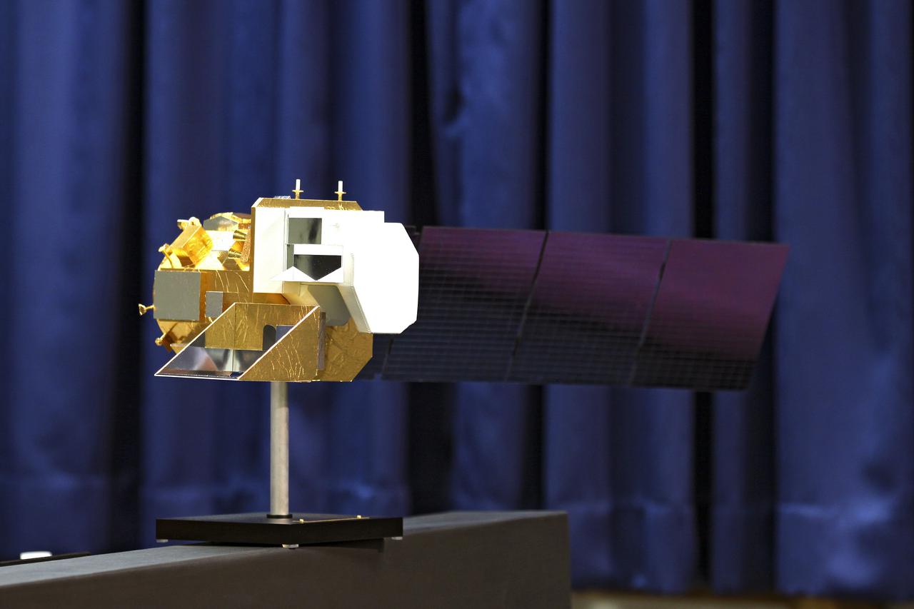
VANDENBERG AFB, Calif. -- A scale model of NASA's Landsat Data Continuity Mission, or LDCM, satellite was displayed at a prelaunch news conference at Vandenberg Air Force Base in California. The Landsat Data Continuity Mission LDCM is the future of Landsat satellites. It will continue to obtain valuable data and imagery to be used in agriculture, education, business, science, and government. The Landsat Program provides repetitive acquisition of high resolution multispectral data of the Earth's surface on a global basis. The data from the Landsat spacecraft constitute the longest record of the Earth's continental surfaces as seen from space. It is a record unmatched in quality, detail, coverage, and value. Liftoff is planned for Feb. 11, 2013 aboard a United Launch Alliance Atlas V rocket. For more information, visit: http:__www.nasa.gov_mission_pages_landsat_main_index.html Photo credit: NASA_Kim Shiflett
VANDENBERG AFB, Calif. -- At Vandenberg Air Force Base, Calif., NASA social media followers are briefed on the agency's Landsat Data Continuity Mission, or LDCM, satellite mission. In the background, the satellite is mounted atop a United Launch Alliance Atlas V rocket in the gantry at Space Launch Complex 3E. The Landsat Data Continuity Mission LDCM is the future of Landsat satellites. It will continue to obtain valuable data and imagery to be used in agriculture, education, business, science, and government. The Landsat Program provides repetitive acquisition of high resolution multispectral data of the Earth's surface on a global basis. The data from the Landsat spacecraft constitute the longest record of the Earth's continental surfaces as seen from space. It is a record unmatched in quality, detail, coverage, and value. Liftoff is planned for Feb. 11, 2013 aboard a United Launch Alliance Atlas V rocket. For more information, visit: http:__www.nasa.gov_mission_pages_landsat_main_index.html Photo credit: NASA_Kim Shiflett
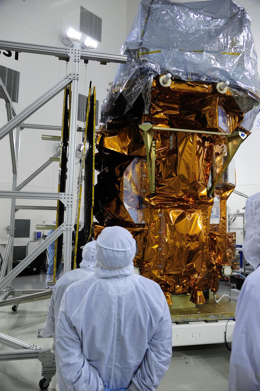
VANDENBERG AFB, Calif. -- At the Astrotech processing facility at Vandenberg Air Force Base, Calif., NASA's Landsat Data Continuity Mission, or LDCM, satellite is undergoing close-outs prior to encapsulation in the payload fairing. The Landsat Data Continuity Mission LDCM is the future of Landsat satellites. It will continue to obtain valuable data and imagery to be used in agriculture, education, business, science, and government. The Landsat Program provides repetitive acquisition of high resolution multispectral data of the Earth's surface on a global basis. The data from the Landsat spacecraft constitute the longest record of the Earth's continental surfaces as seen from space. It is a record unmatched in quality, detail, coverage, and value. Liftoff is planned for Feb. 11, 2013 aboard a United Launch Alliance Atlas V rocket. For more information, visit: http:__www.nasa.gov_mission_pages_landsat_main_index.html Photo credit: NASA
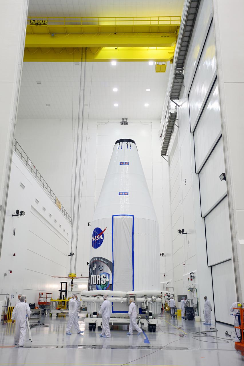
CAPE CANAVERAL, Fla. –- Enclosed in its payload fairing, NASA's Tracking and Data Relay Satellite, TDRS-K, is being lifted for placement atop a United Launch Alliance Atlas V rocket at Cape Canaveral Air Force Station's Space Launch Complex 41. Liftoff for the TDRS-K is planned for January 30, 2013. The TDRS-K spacecraft is part of the next-generation series in the Tracking and Data Relay Satellite System, a constellation of space-based communication satellites providing tracking, telemetry, command and high-bandwidth data return services. For more information, visit http:__www.nasa.gov_mission_pages_tdrs_index.html Photo credit: NASA_ Glenn Bension

CAPE CANAVERAL, Fla. –- Technicians move NASA's Tracking and Data Relay Satellite, TDRS-K, into position for mating to a United Launch Alliance Atlas V rocket at Cape Canaveral Air Force Station's Space Launch Complex 41. Liftoff for the TDRS-K is planned for January 30, 2013. The TDRS-K spacecraft is part of the next-generation series in the Tracking and Data Relay Satellite System, a constellation of space-based communication satellites providing tracking, telemetry, command and high-bandwidth data return services. For more information, visit http:__www.nasa.gov_mission_pages_tdrs_index.html Photo credit: NASA_ Glenn Bension
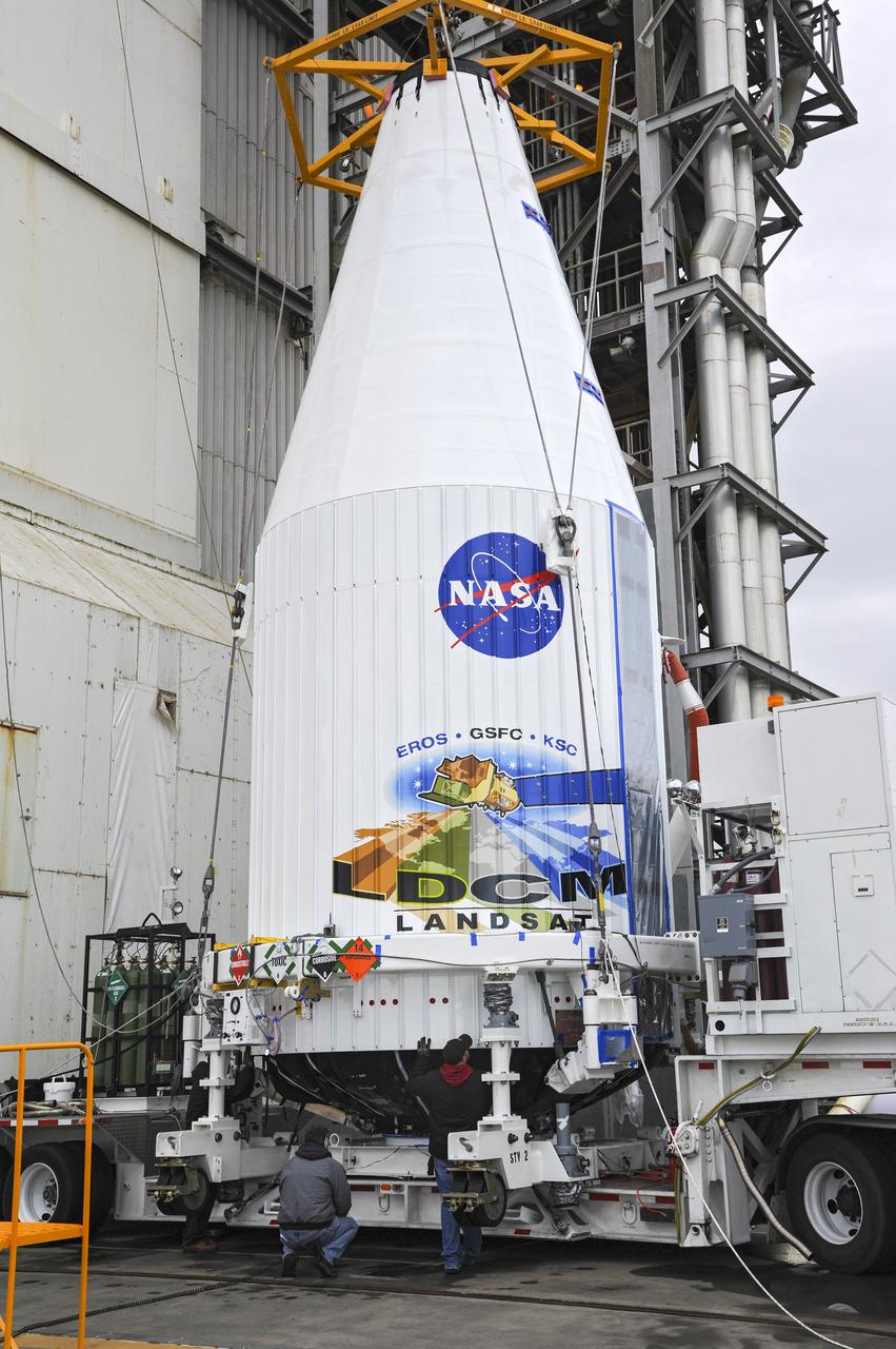
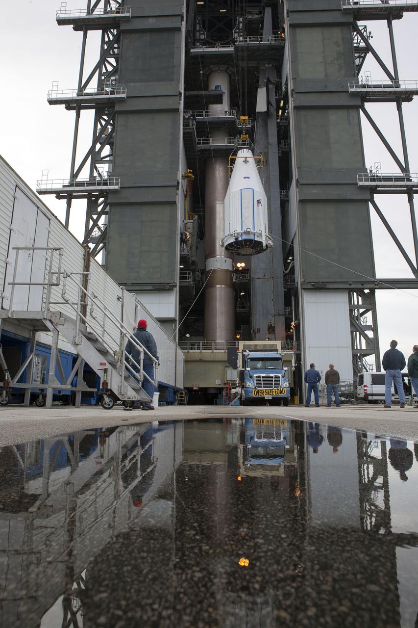
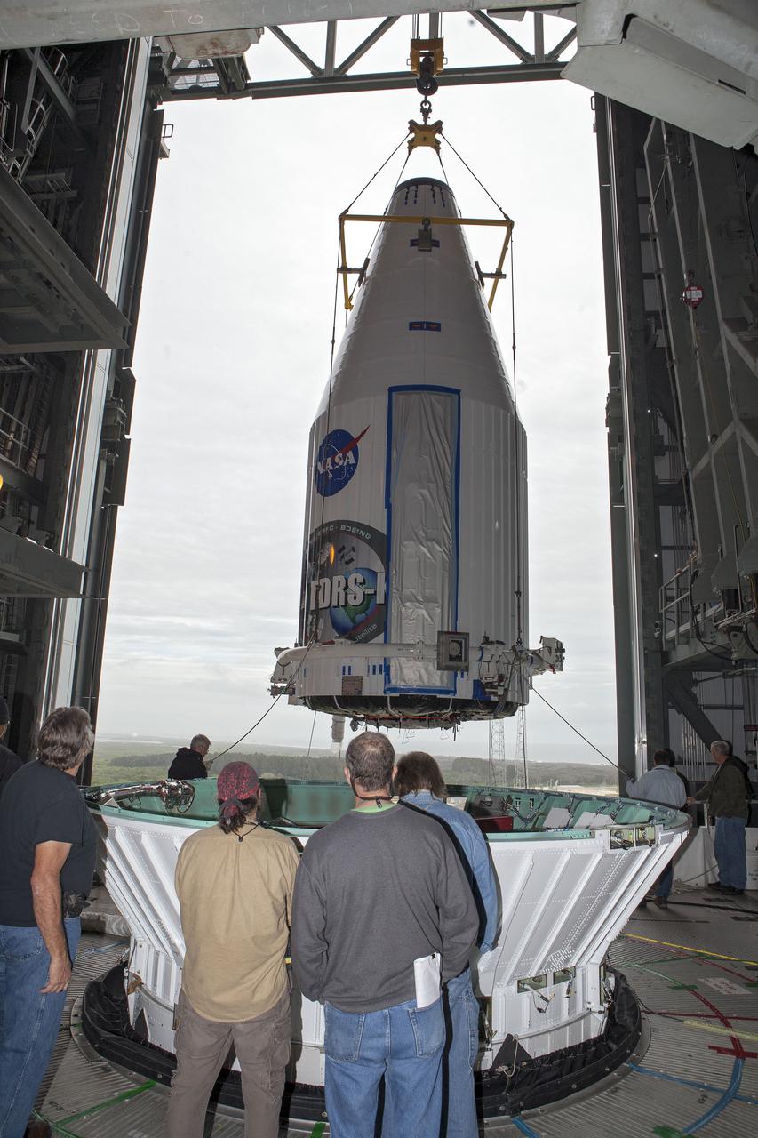
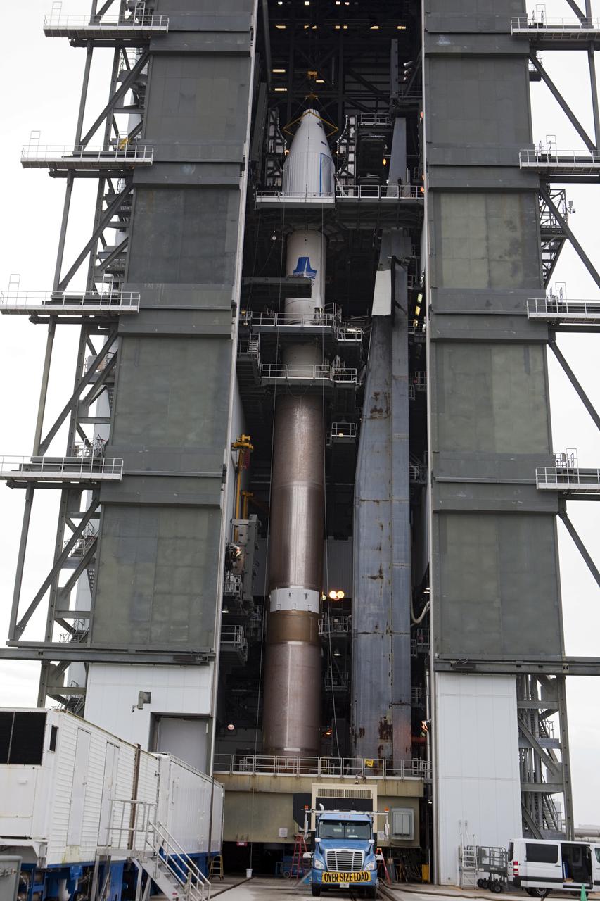
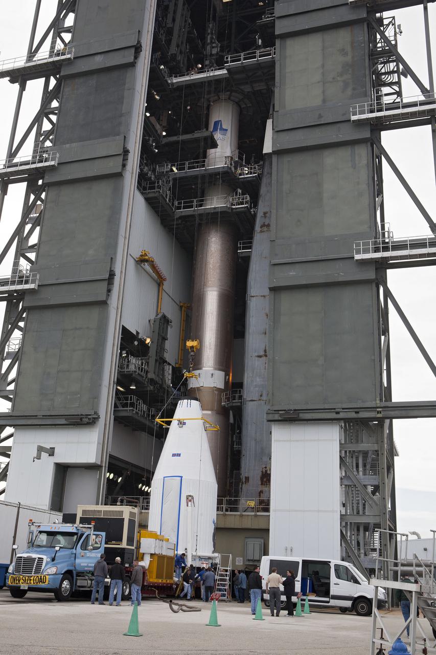
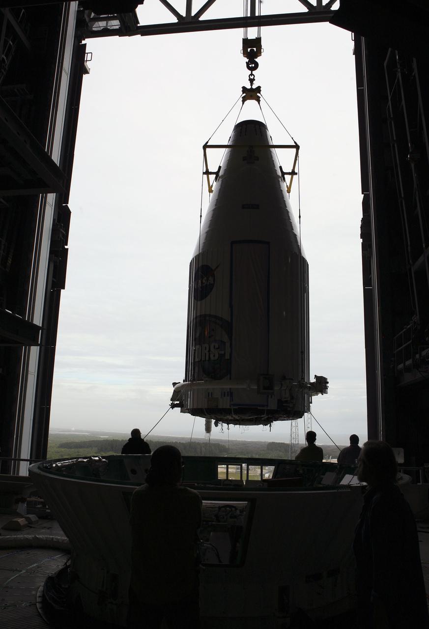
VANDENBERG AFB, Calif. -- The payload fairing containing the Landsat Data Continuity Mission, or LDCM, spacecraft is about to be hoisted atop a United Launch Alliance Atlas V rocket at Space Launch Complex-3E at Vandenberg Air Force Base, Calif. The Landsat Data Continuity Mission LDCM is the future of Landsat satellites. It will continue to obtain valuable data and imagery to be used in agriculture, education, business, science, and government. The Landsat Program provides repetitive acquisition of high resolution multispectral data of the Earth's surface on a global basis. The data from the Landsat spacecraft constitute the longest record of the Earth's continental surfaces as seen from space. It is a record unmatched in quality, detail, coverage, and value. Liftoff is planned for Feb. 11, 2013 aboard a United Launch Alliance Atlas V rocket. For more information, visit: http:__www.nasa.gov_mission_pages_landsat_main_index.html Photo credit: NASA
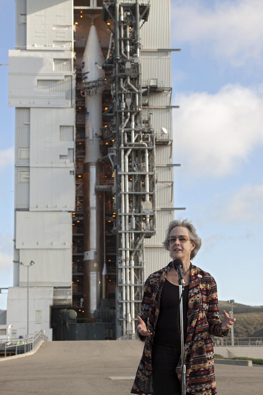
VANDENBERG AFB, Calif. -- At Space Launch Complex 3E at Vandenberg Air Force Base, Anne Castle, assistant secretary for Water and Science, U.S. Department of the Interior, discuss the Landsat Data Continuity Mission, or LDCM, satellite mission with NASA social media followers. The Landsat Data Continuity Mission LDCM is the future of Landsat satellites. It will continue to obtain valuable data and imagery to be used in agriculture, education, business, science, and government. The Landsat Program provides repetitive acquisition of high resolution multispectral data of the Earth's surface on a global basis. The data from the Landsat spacecraft constitute the longest record of the Earth's continental surfaces as seen from space. It is a record unmatched in quality, detail, coverage, and value. Liftoff is planned for Feb. 11, 2013 aboard a United Launch Alliance Atlas V rocket. For more information, visit: http:__www.nasa.gov_mission_pages_landsat_main_index.html Photo credit: NASA_Kim Shiflett
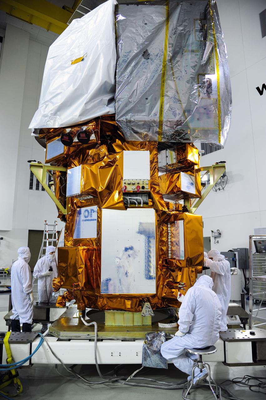
VANDENBERG AFB, Calif. -- At the Astrotech processing facility at Vandenberg Air Force Base, Calif., technicians perform close-out inspections on NASA's Landsat Data Continuity Mission, or LDCM, satellite. The Landsat Data Continuity Mission LDCM is the future of Landsat satellites. It will continue to obtain valuable data and imagery to be used in agriculture, education, business, science, and government. The Landsat Program provides repetitive acquisition of high resolution multispectral data of the Earth's surface on a global basis. The data from the Landsat spacecraft constitute the longest record of the Earth's continental surfaces as seen from space. It is a record unmatched in quality, detail, coverage, and value. Liftoff is planned for Feb. 11, 2013 aboard a United Launch Alliance Atlas V rocket. For more information, visit: http:__www.nasa.gov_mission_pages_landsat_main_index.html Photo credit: NASA
VANDENBERG AIR FORCE BASE, Calif. -- Media attending a post-launch news conference at Vandenberg Air Force Base, Calif. heard from Michael Luther, deputy associate administrator for programs, Science Mission Directorate at NASA Headquarters. The Landsat Data Continuity Mission LDCM is the future of Landsat satellites. It will continue to obtain valuable data and imagery to be used in agriculture, education, business, science, and government. The Landsat Program provides repetitive acquisition of high resolution multispectral data of the Earth's surface on a global basis. The data from the Landsat spacecraft constitute the longest record of the Earth's continental surfaces as seen from space. It is a record unmatched in quality, detail, coverage, and value. Liftoff took place at 10:02 a.m. PST 1:02 P.M. EST) on Feb. 11, 2013 aboard a United Launch Alliance Atlas V rocket. For more information, visit: http:__www.nasa.gov_mission_pages_landsat_main_index.html Photo credit: NASA_Kim Shiflett
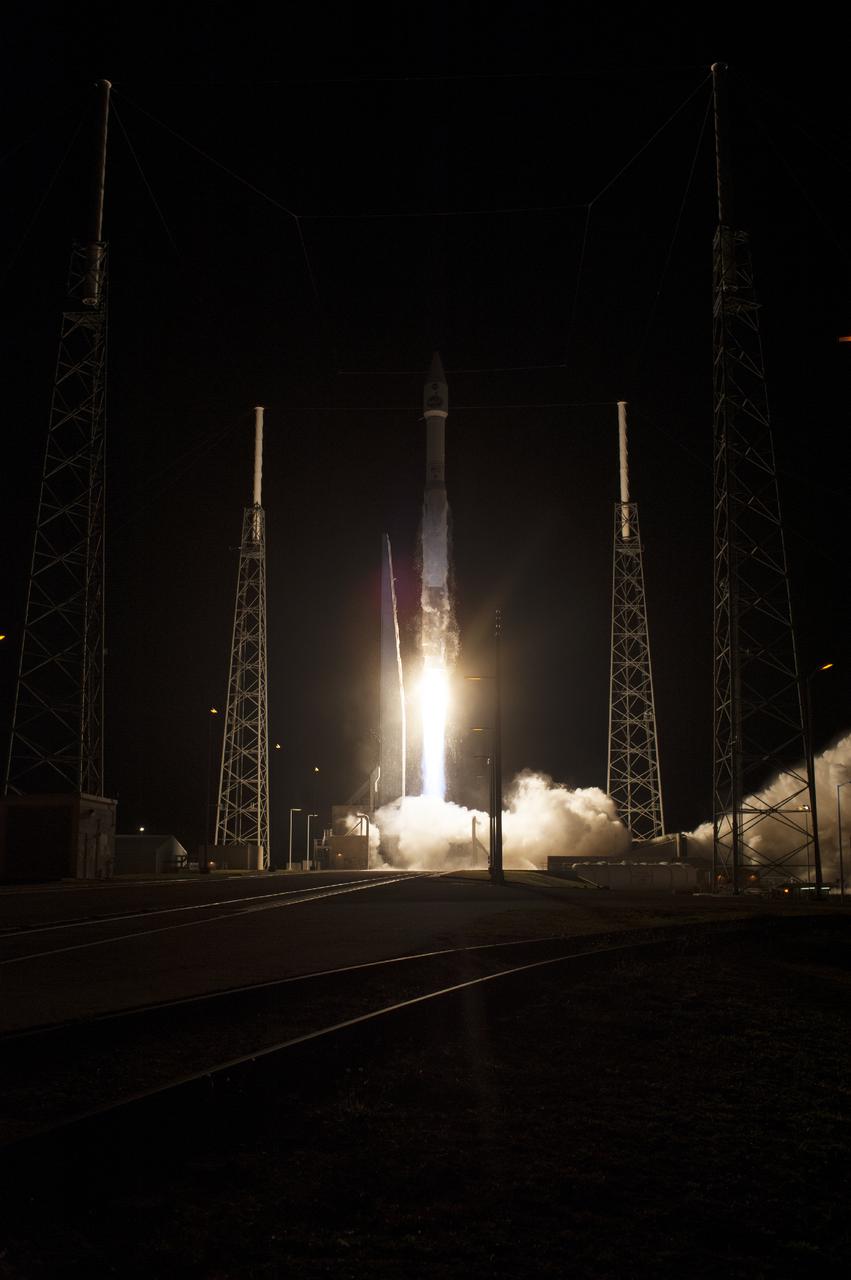
CAPE CANAVERAL, Fla. – The United Launch Alliance Atlas V rocket lifts off from Space Launch Complex 41 at Cape Canaveral Air Force Station carrying NASA's Tracking and Data Relay Satellite, or TDRS-L, spacecraft to Earth orbit. Liftoff was at 9:33 p.m. EST. The TDRS-L spacecraft is the second of three new satellites designed to ensure vital operational continuity for NASA by expanding the lifespan of the Tracking and Data Relay Satellite System TDRSS fleet, which consists of eight satellites in geosynchronous orbit. The spacecraft provide tracking, telemetry, command and high bandwidth data return services for numerous science and human exploration missions orbiting Earth. These include NASA's Hubble Space Telescope and the International Space Station. TDRS-L has a high-performance solar panel designed for more spacecraft power to meet the growing S-band communications requirements. TDRSS is one of NASA Space Communication and Navigation’s SCaN three networks providing space communications to NASA’s missions. For more information more about TDRS-L, visit: http:__www.nasa.gov_tdrs To learn more about SCaN, visit: www.nasa.gov_scan Photo credit: NASA_Tony Gray and Sandy Joseph
CAPE CANAVERAL, Fla. –- Technicians move NASA's Tracking and Data Relay Satellite, TDRS-K, into position for mating to a United Launch Alliance Atlas V rocket at Cape Canaveral Air Force Station's Space Launch Complex 41. Liftoff for the TDRS-K is planned for January 30, 2013. The TDRS-K spacecraft is part of the next-generation series in the Tracking and Data Relay Satellite System, a constellation of space-based communication satellites providing tracking, telemetry, command and high-bandwidth data return services. For more information, visit http:__www.nasa.gov_mission_pages_tdrs_index.html Photo credit: NASA_ Glenn Bension
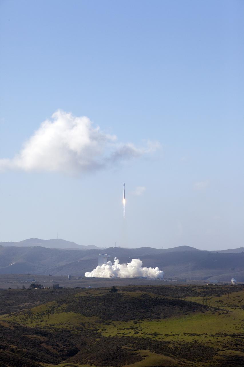
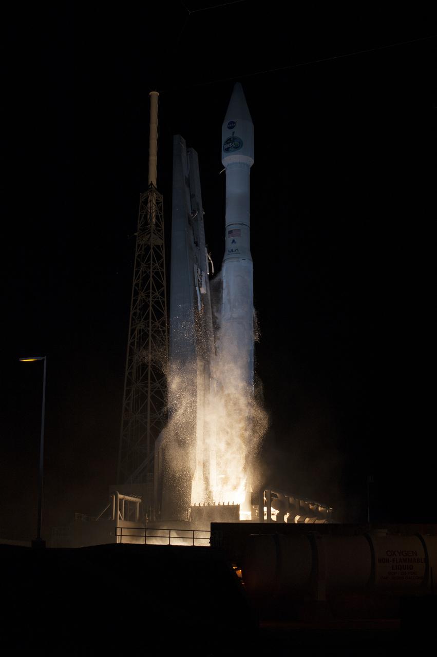
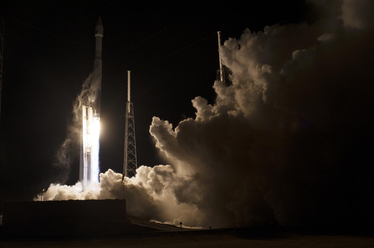
VANDENBERG AFB, Calif. -- The Landsat Data Continuity Mission spacecraft lifted off at 1:02 p.m. EST, 10:02 a.m. PST) atop a United Launch Alliance Atlas V rocket from Space Launch Complex 3 at California's Vandenberg Air Force Base. The Landsat Data Continuity Mission LDCM is the future of Landsat satellites. It will continue to obtain valuable data and imagery to be used in agriculture, education, business, science, and government. The Landsat Program provides repetitive acquisition of high resolution multispectral data of the Earth's surface on a global basis. The data from the Landsat spacecraft constitute the longest record of the Earth's continental surfaces as seen from space. It is a record unmatched in quality, detail, coverage, and value. For more information, visit: http:__www.nasa.gov_mission_pages_landsat_main_index.html Photo credit: NASA_Kim Shiflett

VANDENBERG AFB, Calif. -- During a news conference at Vandenberg Air Force Base, Calif. prior to the launch of NASA's Landsat Data Continuity Mission, or LDCM, media representative heard from Dr. Thomas Loveland, senior scientist and co-chair of the Landsat Science Team U.S. Geological Survey Earth Resources Observation and Science Center, Kass Green, Landsat scientist and president of Kass Green and Associates, and Dr. Mike Wulder, senior research scientist of the Landsat Science Team Canadian Forest Service, Natural Resources Canada. The Landsat Data Continuity Mission LDCM is the future of Landsat satellites. It will continue to obtain valuable data and imagery to be used in agriculture, education, business, science, and government. The Landsat Program provides repetitive acquisition of high resolution multispectral data of the Earth's surface on a global basis. The data from the Landsat spacecraft constitute the longest record of the Earth's continental surfaces as seen from space. It is a record unmatched in quality, detail, coverage, and value. Liftoff is planned for Feb. 11, 2013 aboard a United Launch Alliance Atlas V rocket. For more information, visit: http:__www.nasa.gov_mission_pages_landsat_main_index.html Photo credit: NASA_Kim Shiflett
VANDENBERG AFB, Calif. -- At Space Launch Complex 3E at Vandenberg Air Force Base, NASA Administrator Charles Bolden discusses the Landsat Data Continuity Mission, or LDCM, satellite mission with NASA social media followers. Looking on, to the right, is Kennedy Space Center Director Bob Cabana. The Landsat Data Continuity Mission LDCM is the future of Landsat satellites. It will continue to obtain valuable data and imagery to be used in agriculture, education, business, science, and government. The Landsat Program provides repetitive acquisition of high resolution multispectral data of the Earth's surface on a global basis. The data from the Landsat spacecraft constitute the longest record of the Earth's continental surfaces as seen from space. It is a record unmatched in quality, detail, coverage, and value. Liftoff is planned for Feb. 11, 2013 aboard a United Launch Alliance Atlas V rocket. For more information, visit: http:__www.nasa.gov_mission_pages_landsat_main_index.html Photo credit: NASA_Kim Shiflett

CAPE CANAVERAL, Fla. – In the Hangar AE Mission Director's Center at Cape Canaveral Air Force Station in Florida, NASA and contractor managers and engineers monitor progress of the countdown for the launch the agency's Tracking and Data Relay Satellite, or TDRS-L, spacecraft atop a United Launch Alliance Atlas V rocket. The TDRS-L spacecraft is the second of three new satellites designed to ensure vital operational continuity for NASA by expanding the lifespan of the Tracking and Data Relay Satellite System TDRSS fleet, which consists of eight satellites in geosynchronous orbit. The spacecraft provide tracking, telemetry, command and high bandwidth data return services for numerous science and human exploration missions orbiting Earth. These include NASA's Hubble Space Telescope and the International Space Station. TDRS-L has a high-performance solar panel designed for more spacecraft power to meet the growing S-band communications requirements. TDRSS is one of NASA Space Communication and Navigation’s SCaN three networks providing space communications to NASA’s missions. For more information more about TDRS-L, visit: http:__www.nasa.gov_tdrs To learn more about SCaN, visit: www.nasa.gov_scan Photo credit: NASA_Kim Shiflett
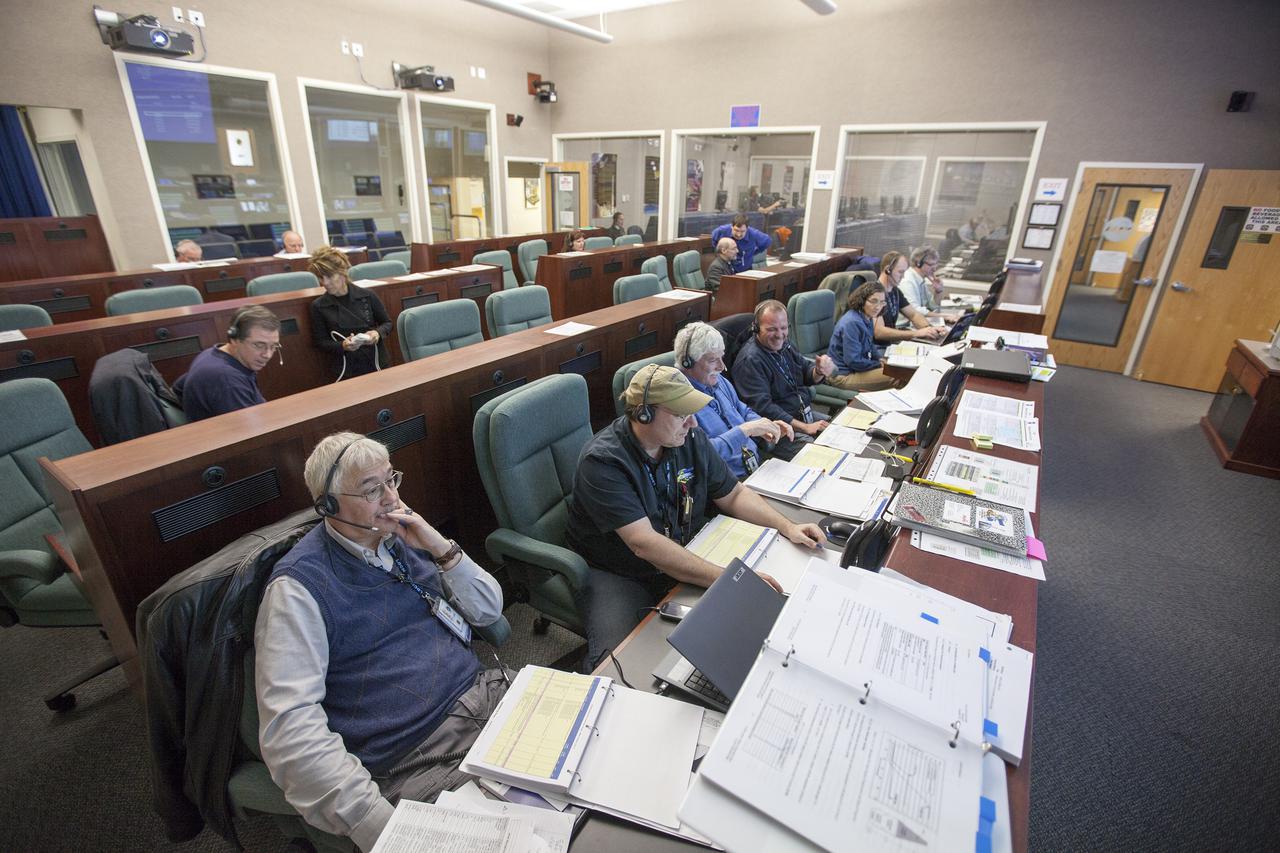
VANDENBERG AFB, Calif. -- From their consoles in the Mission Director's Center at Vandenberg Air Force Base, launch controllers monitor the countdown for a United Launch Alliance Atlas V with the Landsat Data Continuity Mission, or LDCM, satellite prior to liftoff. The Landsat Data Continuity Mission, or LDCM, is the future of Landsat satellites. It will continue to obtain valuable data and imagery to be used in agriculture, education, business, science, and government. The Landsat Program provides repetitive acquisition of high resolution multispectral data of the Earth's surface on a global basis. The data from the Landsat spacecraft constitute the longest record of the Earth's continental surfaces as seen from space. It is a record unmatched in quality, detail, coverage, and value. Liftoff is planned for Feb. 11, 2013 aboard a United Launch Alliance Atlas V rocket. For more information, visit: http:__www.nasa.gov_mission_pages_landsat_main_index.html Photo credit: NASA_ Kim Shiflett
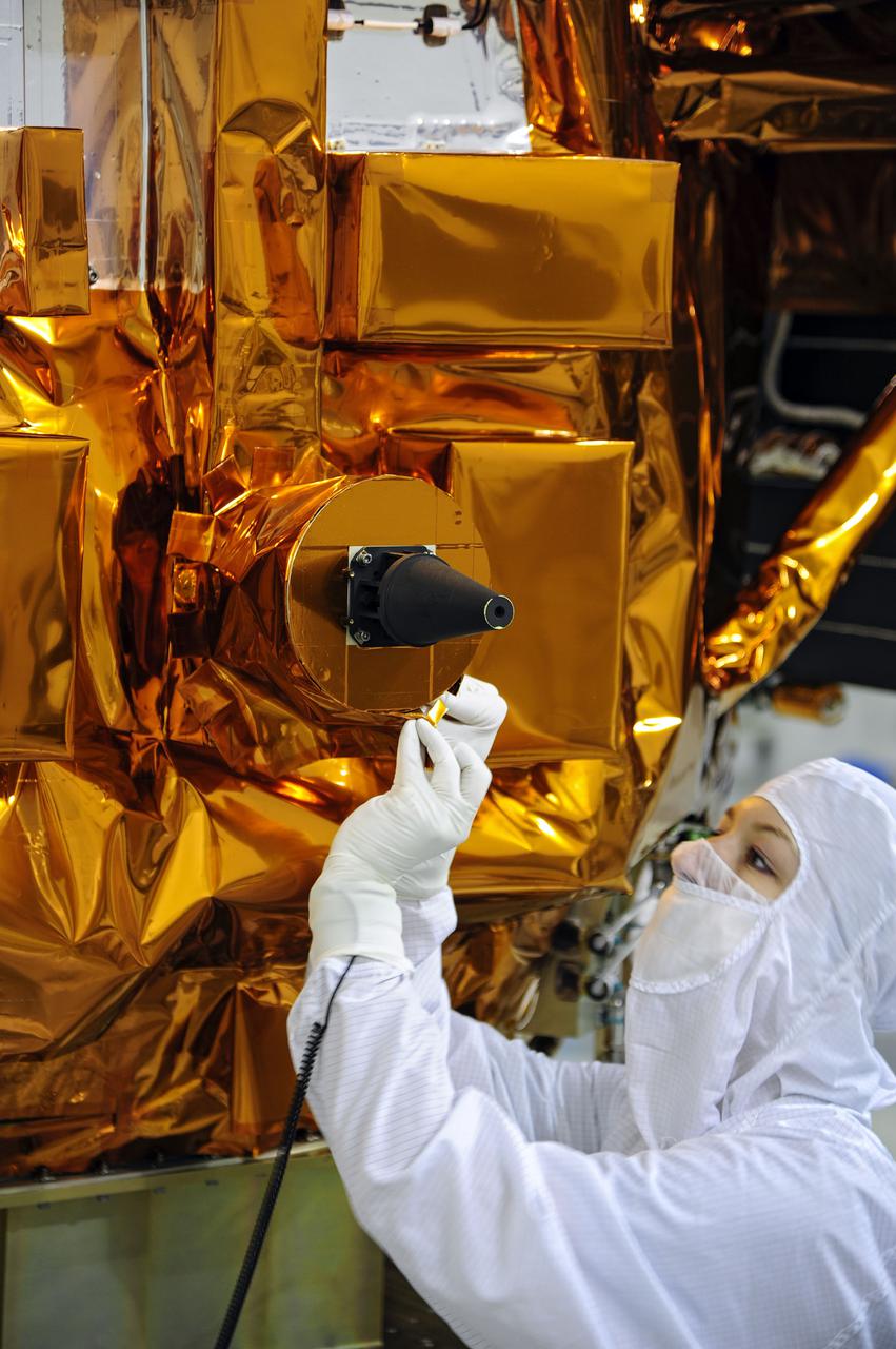
VANDENBERG AFB, Calif. -- At the Astrotech processing facility at Vandenberg Air Force Base, Calif., technicians perform close-out inspections on NASA's Landsat Data Continuity Mission, or LDCM, satellite. The Landsat Data Continuity Mission LDCM is the future of Landsat satellites. It will continue to obtain valuable data and imagery to be used in agriculture, education, business, science, and government. The Landsat Program provides repetitive acquisition of high resolution multispectral data of the Earth's surface on a global basis. The data from the Landsat spacecraft constitute the longest record of the Earth's continental surfaces as seen from space. It is a record unmatched in quality, detail, coverage, and value. Liftoff is planned for Feb. 11, 2013 aboard a United Launch Alliance Atlas V rocket. For more information, visit: http:__www.nasa.gov_mission_pages_landsat_main_index.html Photo credit: NASA

VANDENBERG AIR FORCE BASE, Calif. -- Media attending a post-launch news conference at Vandenberg Air Force Base, Calif. heard from Ken Schwer, LDCM project manager Goddard Space Flight Center, Greenbelt, Md. The Landsat Data Continuity Mission LDCM is the future of Landsat satellites. It will continue to obtain valuable data and imagery to be used in agriculture, education, business, science, and government. The Landsat Program provides repetitive acquisition of high resolution multispectral data of the Earth's surface on a global basis. The data from the Landsat spacecraft constitute the longest record of the Earth's continental surfaces as seen from space. It is a record unmatched in quality, detail, coverage, and value. Liftoff took place at 10:02 a.m. PST 1:02 P.M. EST) on Feb. 11, 2013 aboard a United Launch Alliance Atlas V rocket. For more information, visit: http:__www.nasa.gov_mission_pages_landsat_main_index.html Photo credit: NASA_Kim Shiflett
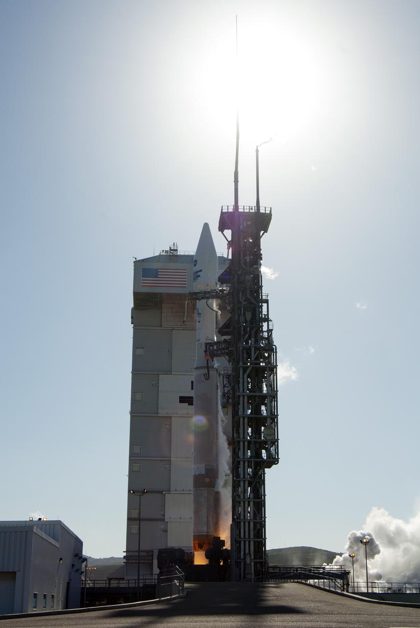
VANDENBERG AFB, Calif. -- The Landsat Data Continuity Mission spacecraft lifts off at 1:02 p.m. EST, 10:02 a.m. PST) atop a United Launch Alliance Atlas V rocket from Space Launch Complex 3 at California's Vandenberg Air Force Base. The Landsat Data Continuity Mission LDCM is the future of Landsat satellites. It will continue to obtain valuable data and imagery to be used in agriculture, education, business, science, and government. The Landsat Program provides repetitive acquisition of high resolution multispectral data of the Earth's surface on a global basis. The data from the Landsat spacecraft constitute the longest record of the Earth's continental surfaces as seen from space. It is a record unmatched in quality, detail, coverage, and value. For more information, visit: http:__www.nasa.gov_mission_pages_landsat_main_index.html Photo credit: NASA_Kim Shiflett
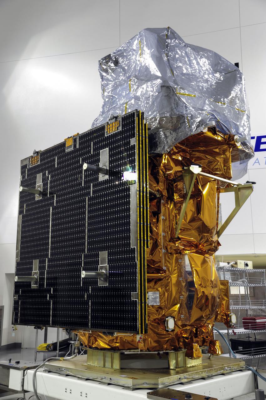
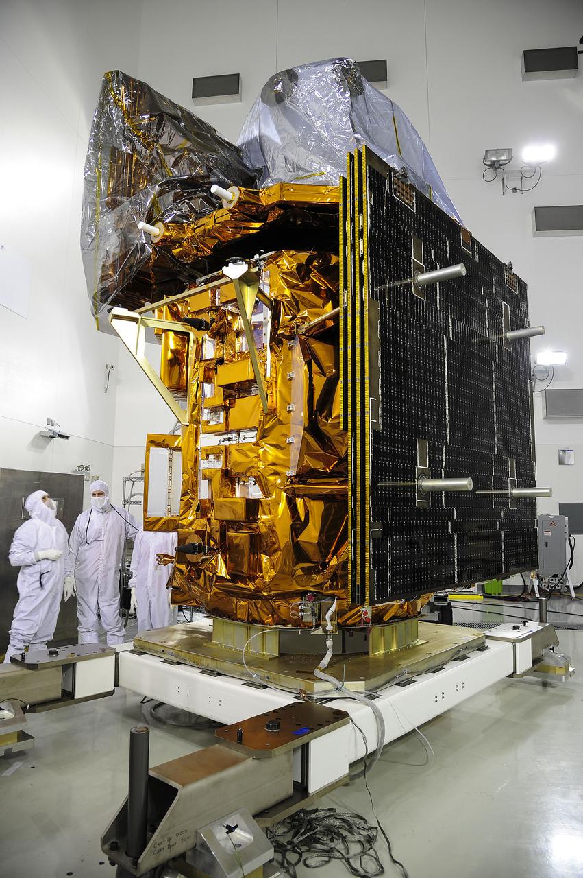
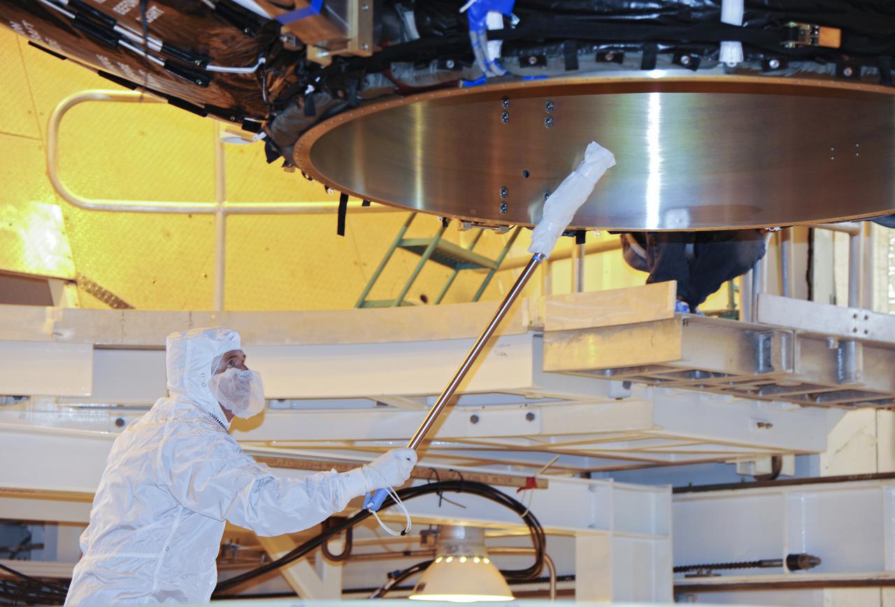
VANDENBERG AFB, Calif. -- In the Astrotech processing facility at Vandenberg Air Force Base, Calif., technicians test the solar arrays on NASA's Landsat Data Continuity Mission, or LDCM, satellite to ensure they will deploy properly in orbit. The Landsat Data Continuity Mission LDCM is the future of Landsat satellites. It will continue to obtain valuable data and imagery to be used in agriculture, education, business, science, and government. The Landsat Program provides repetitive acquisition of high resolution multispectral data of the Earth's surface on a global basis. The data from the Landsat spacecraft constitute the longest record of the Earth's continental surfaces as seen from space. It is a record unmatched in quality, detail, coverage, and value. Liftoff is planned for Feb. 11, 2013 aboard a United Launch Alliance Atlas V rocket. For more information, visit: http:__www.nasa.gov_mission_pages_landsat_main_index.html Photo credit: NASA
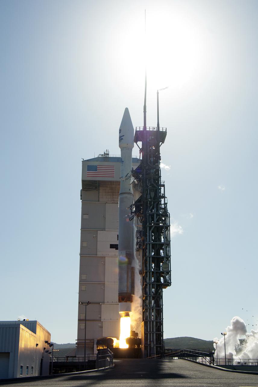
VANDENBERG AFB, Calif. -- The Landsat Data Continuity Mission spacecraft lifts off at 1:02 p.m. EST, 10:02 a.m. PST) atop a United Launch Alliance Atlas V rocket from Space Launch Complex 3 at California's Vandenberg Air Force Base. The Landsat Data Continuity Mission LDCM is the future of Landsat satellites. It will continue to obtain valuable data and imagery to be used in agriculture, education, business, science, and government. The Landsat Program provides repetitive acquisition of high resolution multispectral data of the Earth's surface on a global basis. The data from the Landsat spacecraft constitute the longest record of the Earth's continental surfaces as seen from space. It is a record unmatched in quality, detail, coverage, and value. For more information, visit: http:__www.nasa.gov_mission_pages_landsat_main_index.html Photo credit: NASA_Kim Shiflett

CAPE CANAVERAL, Fla. –- Enclosed in its payload fairing, NASA's Tracking and Data Relay Satellite, TDRS-K, is being lifted for placement atop a United Launch Alliance Atlas V rocket at Cape Canaveral Air Force Station's Space Launch Complex 41. Liftoff for the TDRS-K is planned for January 30, 2013. The TDRS-K spacecraft is part of the next-generation series in the Tracking and Data Relay Satellite System, a constellation of space-based communication satellites providing tracking, telemetry, command and high-bandwidth data return services. For more information, visit http:__www.nasa.gov_mission_pages_tdrs_index.html Photo credit: NASA_ Glenn Bension
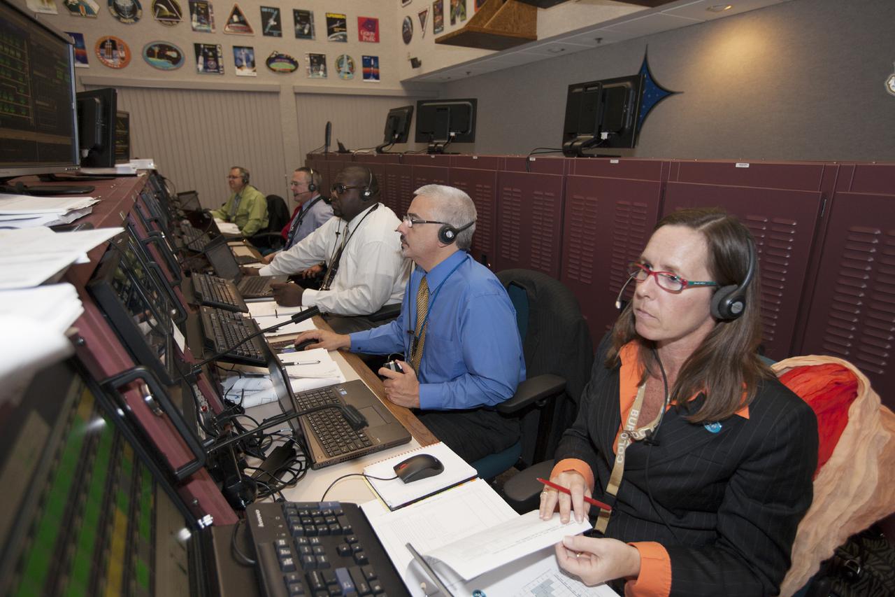
CAPE CANAVERAL, Fla. – In the Hangar AE Launch Vehicle Data Center at Cape Canaveral Air Force Station in Florida, NASA and contractor managers and engineers monitor progress of the countdown for the launch the agency's Tracking and Data Relay Satellite, or TDRS-L, spacecraft atop a United Launch Alliance Atlas V rocket. The TDRS-L spacecraft is the second of three new satellites designed to ensure vital operational continuity for NASA by expanding the lifespan of the Tracking and Data Relay Satellite System TDRSS fleet, which consists of eight satellites in geosynchronous orbit. The spacecraft provide tracking, telemetry, command and high bandwidth data return services for numerous science and human exploration missions orbiting Earth. These include NASA's Hubble Space Telescope and the International Space Station. TDRS-L has a high-performance solar panel designed for more spacecraft power to meet the growing S-band communications requirements. TDRSS is one of NASA Space Communication and Navigation’s SCaN three networks providing space communications to NASA’s missions. For more information more about TDRS-L, visit: http:__www.nasa.gov_tdrs To learn more about SCaN, visit: www.nasa.gov_scan Photo credit: NASA_Kim Shiflett
CAPE CANAVERAL, Fla. – The United Launch Alliance Atlas V rocket lifts off from Space Launch Complex 41 at Cape Canaveral Air Force Station carrying NASA's Tracking and Data Relay Satellite, or TDRS-L, spacecraft to Earth orbit. Liftoff was at 9:33 p.m. EST. The TDRS-L spacecraft is the second of three new satellites designed to ensure vital operational continuity for NASA by expanding the lifespan of the Tracking and Data Relay Satellite System TDRSS fleet, which consists of eight satellites in geosynchronous orbit. The spacecraft provide tracking, telemetry, command and high bandwidth data return services for numerous science and human exploration missions orbiting Earth. These include NASA's Hubble Space Telescope and the International Space Station. TDRS-L has a high-performance solar panel designed for more spacecraft power to meet the growing S-band communications requirements. TDRSS is one of NASA Space Communication and Navigation’s SCaN three networks providing space communications to NASA’s missions. For more information more about TDRS-L, visit: http:__www.nasa.gov_tdrs To learn more about SCaN, visit: www.nasa.gov_scan Photo credit: NASA_Tony Gray and Sandy Joseph
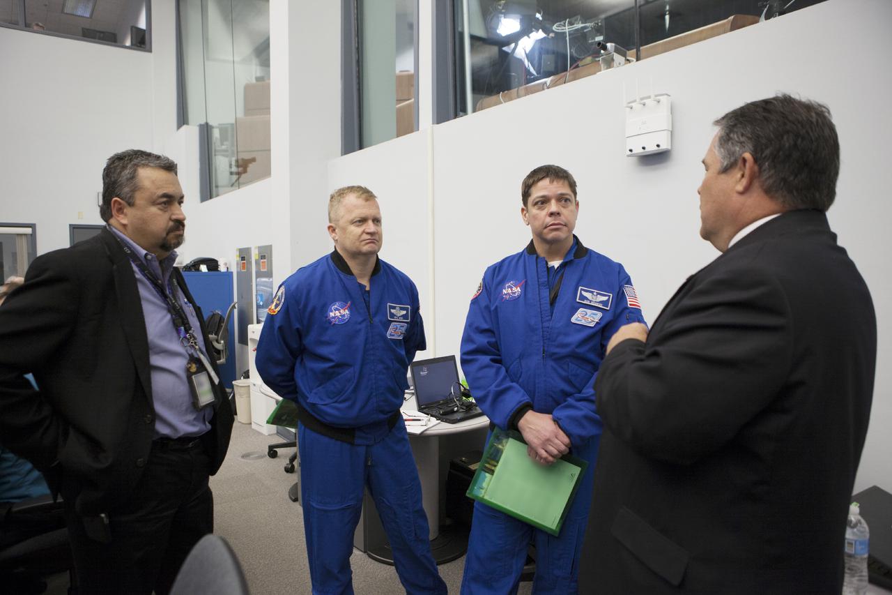
VANDENBERG AFB, Calif. -- NASA astronaut Piers Sellers speaks to NASA social media followers at Vandenberg Air Force Base, Calif., prior to the launch of the agency's Landsat Data Continuity Mission, or LDCM, satellite. The Landsat Data Continuity Mission LDCM is the future of Landsat satellites. It will continue to obtain valuable data and imagery to be used in agriculture, education, business, science, and government. The Landsat Program provides repetitive acquisition of high resolution multispectral data of the Earth's surface on a global basis. The data from the Landsat spacecraft constitute the longest record of the Earth's continental surfaces as seen from space. It is a record unmatched in quality, detail, coverage, and value. Liftoff is planned for Feb. 11, 2013 aboard a United Launch Alliance Atlas V rocket. For more information, visit: http:__www.nasa.gov_mission_pages_landsat_main_index.html Photo credit: NASA_Kim Shiflett
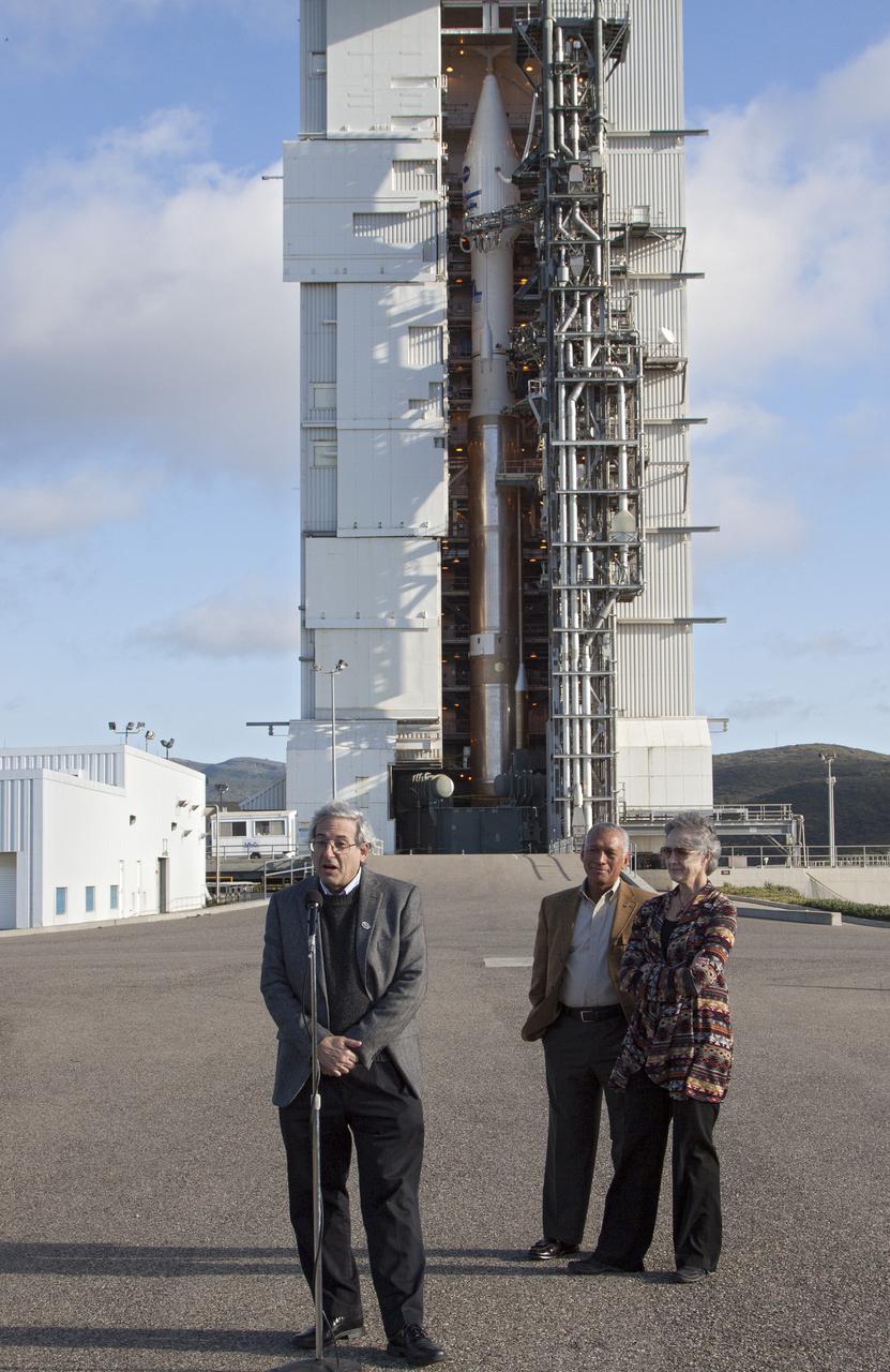
VANDENBERG AFB, Calif. -- NASA officials tour Space Launch Complex 3E at Vandenberg Air Force Base, prior to the launch of the Landsat Data Continuity Mission, or LDCM, satellite. In the front row, from the left, are NASA Administrator Charles Bolden, Anne Castle, assistant secretary for Water and Science, U.S. Department of the Interior, and Kennedy Space Center Director Bob Cabana. In the background is the payload fairing containing the LDCM satellite which is mounted atop an Atlas V rocket. The Landsat Data Continuity Mission LDCM is the future of Landsat satellites. It will continue to obtain valuable data and imagery to be used in agriculture, education, business, science, and government. The Landsat Program provides repetitive acquisition of high resolution multispectral data of the Earth's surface on a global basis. The data from the Landsat spacecraft constitute the longest record of the Earth's continental surfaces as seen from space. It is a record unmatched in quality, detail, coverage, and value. Liftoff is planned for Feb. 11, 2013 aboard a United Launch Alliance Atlas V rocket. For more information, visit: http:__www.nasa.gov_mission_pages_landsat_main_index.html Photo credit: NASA_Kim Shiflett
VANDENBERG AFB, Calif. -- NASA and contractor officials discussed NASA's readiness to launch the Landsat Data Continuity Mission, or LDCM, during a prelaunch news conference at Vandenberg Air Force Base, Calif. Participants included NASA Launch Director Omar Baez from Kennedy Space Center. The Landsat Data Continuity Mission LDCM is the future of Landsat satellites. It will continue to obtain valuable data and imagery to be used in agriculture, education, business, science, and government. The Landsat Program provides repetitive acquisition of high resolution multispectral data of the Earth's surface on a global basis. The data from the Landsat spacecraft constitute the longest record of the Earth's continental surfaces as seen from space. It is a record unmatched in quality, detail, coverage, and value. Liftoff is planned for Feb. 11, 2013 aboard a United Launch Alliance Atlas V rocket. For more information, visit: http:__www.nasa.gov_mission_pages_landsat_main_index.html Photo credit: NASA_Kim Shiflett
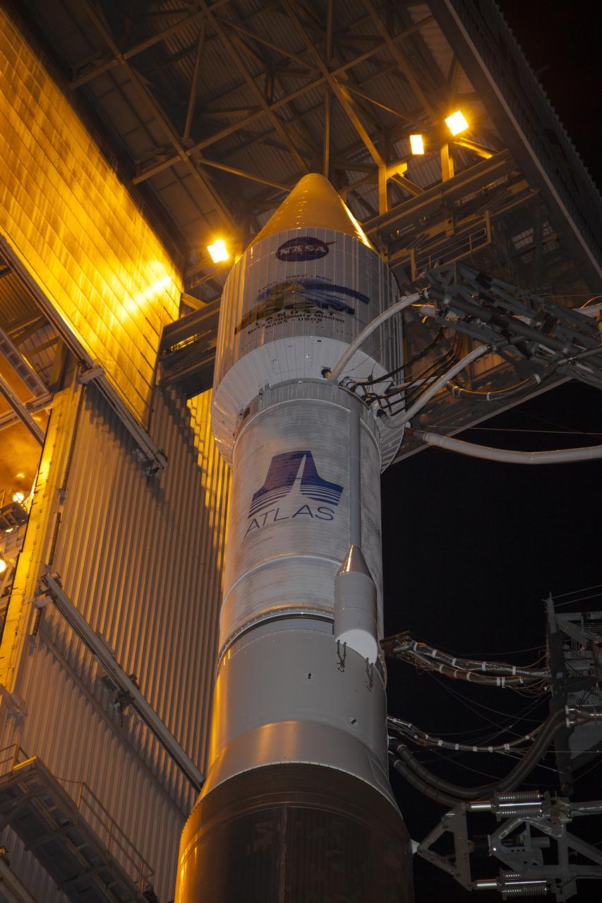
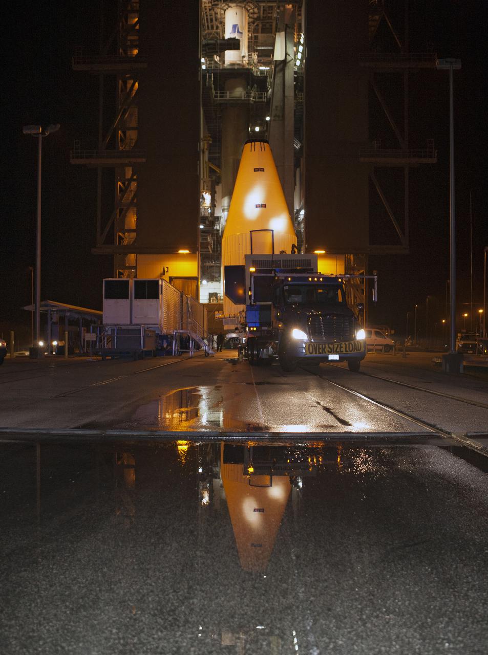
CAPE CANAVERAL, Fla. –- At Cape Canaveral Air Force Station's Space Launch Complex 41, NASA's Tracking and Data Relay Satellite, TDRS-K, has been mated atop to a United Launch Alliance Atlas V rocket. Liftoff for the TDRS-K is planned for January 30, 2013. The TDRS-K spacecraft is part of the next-generation series in the Tracking and Data Relay Satellite System, a constellation of space-based communication satellites providing tracking, telemetry, command and high-bandwidth data return services. For more information, visit http:__www.nasa.gov_mission_pages_tdrs_index.html Photo credit: NASA_ Glenn Bension
VANDENBERG AFB, Calif. -- The payload fairing containing the Landsat Data Continuity Mission, or LDCM, spacecraft is lifted to the top of Space Launch Complex-3E at Vandenberg Air Force Base, Calif. where it will be mounted atop a United Launch Alliance Atlas V rocket. The Landsat Data Continuity Mission LDCM is the future of Landsat satellites. It will continue to obtain valuable data and imagery to be used in agriculture, education, business, science, and government. The Landsat Program provides repetitive acquisition of high resolution multispectral data of the Earth's surface on a global basis. The data from the Landsat spacecraft constitute the longest record of the Earth's continental surfaces as seen from space. It is a record unmatched in quality, detail, coverage, and value. Liftoff is planned for Feb. 11, 2013 aboard a United Launch Alliance Atlas V rocket. For more information, visit: http:__www.nasa.gov_mission_pages_landsat_main_index.html Photo credit: NASA

VANDENBERG AFB, Calif. -- At Vandenberg Air Force Base, Calif., NASA social media followers pose for a group photo. In the background, the satellite is mounted atop a United Launch Alliance Atlas V rocket in the gantry at Space Launch Complex 3E. The Landsat Data Continuity Mission LDCM is the future of Landsat satellites. It will continue to obtain valuable data and imagery to be used in agriculture, education, business, science, and government. The Landsat Program provides repetitive acquisition of high resolution multispectral data of the Earth's surface on a global basis. The data from the Landsat spacecraft constitute the longest record of the Earth's continental surfaces as seen from space. It is a record unmatched in quality, detail, coverage, and value. Liftoff is planned for Feb. 11, 2013 aboard a United Launch Alliance Atlas V rocket. For more information, visit: http:__www.nasa.gov_mission_pages_landsat_main_index.html Photo credit: NASA_Kim Shiflett

VANDENBERG AFB, Calif. -- NASA social media followers at Vandenberg Air Force Base, Calif., listen to speakers describing the agency's Landsat Data Continuity Mission, or LDCM, satellite. The Landsat Data Continuity Mission LDCM is the future of Landsat satellites. It will continue to obtain valuable data and imagery to be used in agriculture, education, business, science, and government. The Landsat Program provides repetitive acquisition of high resolution multispectral data of the Earth's surface on a global basis. The data from the Landsat spacecraft constitute the longest record of the Earth's continental surfaces as seen from space. It is a record unmatched in quality, detail, coverage, and value. Liftoff is planned for Feb. 11, 2013 aboard a United Launch Alliance Atlas V rocket. For more information, visit: http:__www.nasa.gov_mission_pages_landsat_main_index.html Photo credit: NASA_Kim Shiflett
VANDENBERG AFB, Calif. -- At the Astrotech processing facility at Vandenberg Air Force Base, Calif., technicians perform close-outs on NASA's Landsat Data Continuity Mission, or LDCM, satellite. The Landsat Data Continuity Mission LDCM is the future of Landsat satellites. It will continue to obtain valuable data and imagery to be used in agriculture, education, business, science, and government. The Landsat Program provides repetitive acquisition of high resolution multispectral data of the Earth's surface on a global basis. The data from the Landsat spacecraft constitute the longest record of the Earth's continental surfaces as seen from space. It is a record unmatched in quality, detail, coverage, and value. Liftoff is planned for Feb. 11, 2013 aboard a United Launch Alliance Atlas V rocket. For more information, visit: http:__www.nasa.gov_mission_pages_landsat_main_index.html Photo credit: NASA
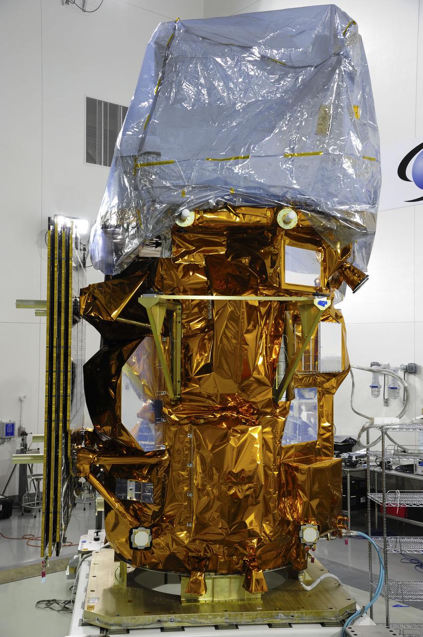
VANDENBERG AFB, Calif. -- At the Astrotech processing facility at Vandenberg Air Force Base, Calif., NASA's Landsat Data Continuity Mission, or LDCM, satellite is undergoing close-outs prior to encapsulation in the payload fairing. The Landsat Data Continuity Mission LDCM is the future of Landsat satellites. It will continue to obtain valuable data and imagery to be used in agriculture, education, business, science, and government. The Landsat Program provides repetitive acquisition of high resolution multispectral data of the Earth's surface on a global basis. The data from the Landsat spacecraft constitute the longest record of the Earth's continental surfaces as seen from space. It is a record unmatched in quality, detail, coverage, and value. Liftoff is planned for Feb. 11, 2013 aboard a United Launch Alliance Atlas V rocket. For more information, visit: http:__www.nasa.gov_mission_pages_landsat_main_index.html Photo credit: NASA
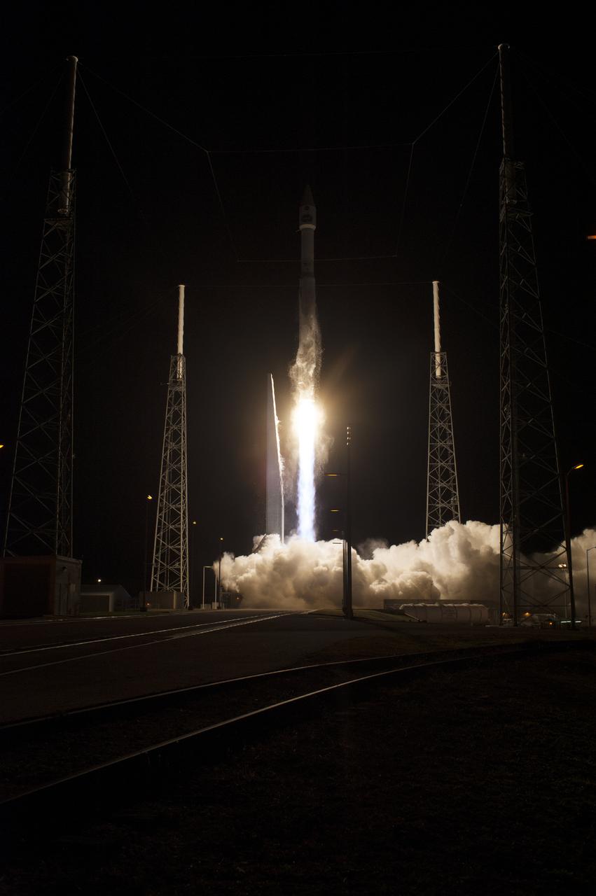
CAPE CANAVERAL, Fla. – The United Launch Alliance Atlas V rocket lifts off from Space Launch Complex 41 at Cape Canaveral Air Force Station carrying NASA's Tracking and Data Relay Satellite, or TDRS-L, spacecraft to Earth orbit. Liftoff was at 9:33 p.m. EST. The TDRS-L spacecraft is the second of three new satellites designed to ensure vital operational continuity for NASA by expanding the lifespan of the Tracking and Data Relay Satellite System TDRSS fleet, which consists of eight satellites in geosynchronous orbit. The spacecraft provide tracking, telemetry, command and high bandwidth data return services for numerous science and human exploration missions orbiting Earth. These include NASA's Hubble Space Telescope and the International Space Station. TDRS-L has a high-performance solar panel designed for more spacecraft power to meet the growing S-band communications requirements. TDRSS is one of NASA Space Communication and Navigation’s SCaN three networks providing space communications to NASA’s missions. For more information more about TDRS-L, visit: http:__www.nasa.gov_tdrs To learn more about SCaN, visit: www.nasa.gov_scan Photo credit: NASA_Tony Gray and Sandy Joseph
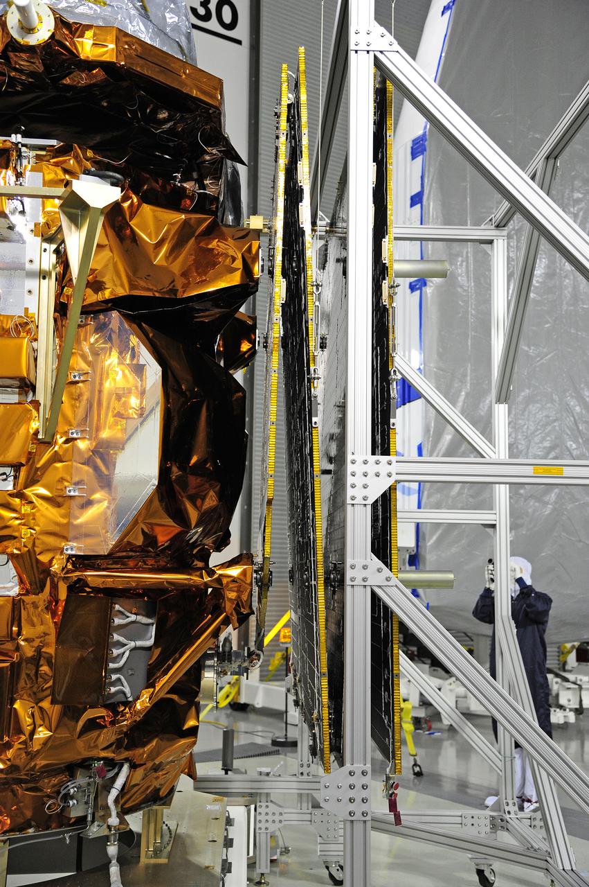
VANDENBERG AFB, Calif. -- In the Astrotech processing facility at Vandenberg Air Force Base, Calif., a technician photographs NASA's Landsat Data Continuity Mission, or LDCM, satellite after the solar arrays were attached and tested. The Landsat Data Continuity Mission LDCM is the future of Landsat satellites. It will continue to obtain valuable data and imagery to be used in agriculture, education, business, science, and government. The Landsat Program provides repetitive acquisition of high resolution multispectral data of the Earth's surface on a global basis. The data from the Landsat spacecraft constitute the longest record of the Earth's continental surfaces as seen from space. It is a record unmatched in quality, detail, coverage, and value. Liftoff is planned for Feb. 11, 2013 aboard a United Launch Alliance Atlas V rocket. For more information, visit: http:__www.nasa.gov_mission_pages_landsat_main_index.html Photo credit: NASA
VANDENBERG AFB, Calif. -- At Space Launch Complex 3E at Vandenberg Air Force Base, NASA Administrator Charles Bolden discusses the Landsat Data Continuity Mission, or LDCM, satellite mission with NASA social media followers. The Landsat Data Continuity Mission LDCM is the future of Landsat satellites. It will continue to obtain valuable data and imagery to be used in agriculture, education, business, science, and government. The Landsat Program provides repetitive acquisition of high resolution multispectral data of the Earth's surface on a global basis. The data from the Landsat spacecraft constitute the longest record of the Earth's continental surfaces as seen from space. It is a record unmatched in quality, detail, coverage, and value. Liftoff is planned for Feb. 11, 2013 aboard a United Launch Alliance Atlas V rocket. For more information, visit: http:__www.nasa.gov_mission_pages_landsat_main_index.html Photo credit: NASA_Kim Shiflett
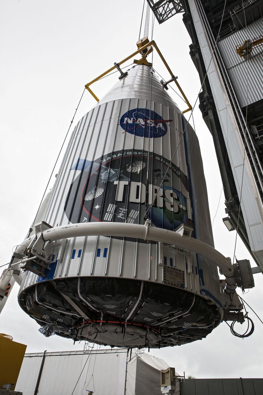
CAPE CANAVERAL, Fla. –- Enclosed in its payload fairing, NASA's Tracking and Data Relay Satellite, TDRS-K, is being lifted for placement atop a United Launch Alliance Atlas V rocket at Cape Canaveral Air Force Station's Space Launch Complex 41. Liftoff for the TDRS-K is planned for January 30, 2013. The TDRS-K spacecraft is part of the next-generation series in the Tracking and Data Relay Satellite System, a constellation of space-based communication satellites providing tracking, telemetry, command and high-bandwidth data return services. For more information, visit http:__www.nasa.gov_mission_pages_tdrs_index.html Photo credit: NASA_ Glenn Bension
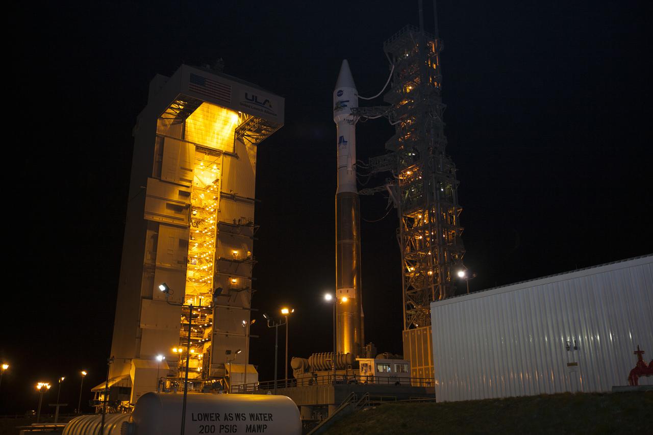
VANDENBERG AFB, Calif. -- At Vandenberg Air Force Base, Calif., NASA's Landsat Data Continuity Mission, or LDCM, satellite is mounted atop a United Launch Alliance Atlas V rocket in the gantry at Space Launch Complex 3E. The Landsat Data Continuity Mission LDCM is the future of Landsat satellites. It will continue to obtain valuable data and imagery to be used in agriculture, education, business, science, and government. The Landsat Program provides repetitive acquisition of high resolution multispectral data of the Earth's surface on a global basis. The data from the Landsat spacecraft constitute the longest record of the Earth's continental surfaces as seen from space. It is a record unmatched in quality, detail, coverage, and value. Liftoff is planned for Feb. 11, 2013 aboard a United Launch Alliance Atlas V rocket. For more information, visit: http:__www.nasa.gov_mission_pages_landsat_main_index.html Photo credit: NASA_Kim Shiflett
VANDENBERG AFB, Calif. -- A technician ensures no contaminants on the payload fairing or the Landsat Data Continuity Mission, or LDCM, spacecraft about to be mounted atop a United Launch Alliance Atlas V rocket at Space Launch Complex-3E at Vandenberg Air Force Base, Calif. The Landsat Data Continuity Mission LDCM is the future of Landsat satellites. It will continue to obtain valuable data and imagery to be used in agriculture, education, business, science, and government. The Landsat Program provides repetitive acquisition of high resolution multispectral data of the Earth's surface on a global basis. The data from the Landsat spacecraft constitute the longest record of the Earth's continental surfaces as seen from space. It is a record unmatched in quality, detail, coverage, and value. Liftoff is planned for Feb. 11, 2013 aboard a United Launch Alliance Atlas V rocket. For more information, visit: http:__www.nasa.gov_mission_pages_landsat_main_index.html Photo credit: NASA
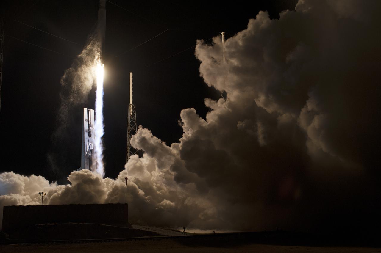
CAPE CANAVERAL, Fla. – The United Launch Alliance Atlas V rocket lifts off from Space Launch Complex 41 at Cape Canaveral Air Force Station carrying NASA's Tracking and Data Relay Satellite, or TDRS-L, spacecraft to Earth orbit. Liftoff was at 9:33 p.m. EST. The TDRS-L spacecraft is the second of three new satellites designed to ensure vital operational continuity for NASA by expanding the lifespan of the Tracking and Data Relay Satellite System TDRSS fleet, which consists of eight satellites in geosynchronous orbit. The spacecraft provide tracking, telemetry, command and high bandwidth data return services for numerous science and human exploration missions orbiting Earth. These include NASA's Hubble Space Telescope and the International Space Station. TDRS-L has a high-performance solar panel designed for more spacecraft power to meet the growing S-band communications requirements. TDRSS is one of NASA Space Communication and Navigation’s SCaN three networks providing space communications to NASA’s missions. For more information more about TDRS-L, visit: http:__www.nasa.gov_tdrs To learn more about SCaN, visit: www.nasa.gov_scan Photo credit: NASA_Tony Gray and Sandy Joseph
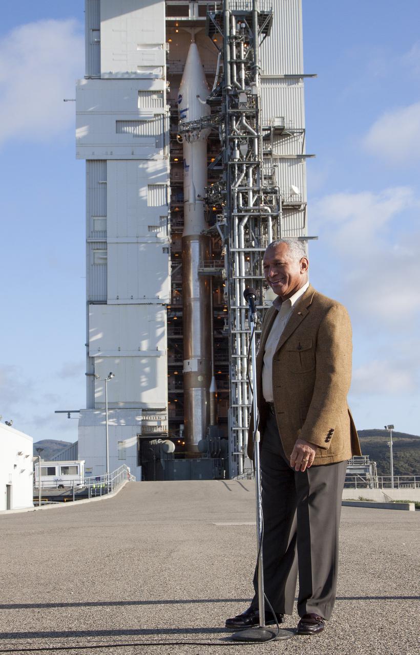
CAPE CANAVERAL, Fla. At a news conference, NASA and United Launch Alliance officials discussed preparations for the planned launch of NASA's Tracking and Data Relay Satellite, TDRS-K, atop an Atlas V rocket. Among those participating in the briefing is Badri Younes, deputy associate administrator, Space Communications and Navigation SCaN, NASA Human Exploration and Operations Mission Directorate in Washington. Liftoff for the TDRS-K is planned for Jan. 30, 2013. The TDRS-K spacecraft is part of the next-generation series in the Tracking and Data Relay Satellite System, a constellation of space-based communication satellites providing tracking, telemetry, command and high-bandwidth data return services. For more information, visit http:__www.nasa.gov_mission_pages_tdrs_index.html Photo credit: NASA_Kim Shiflett
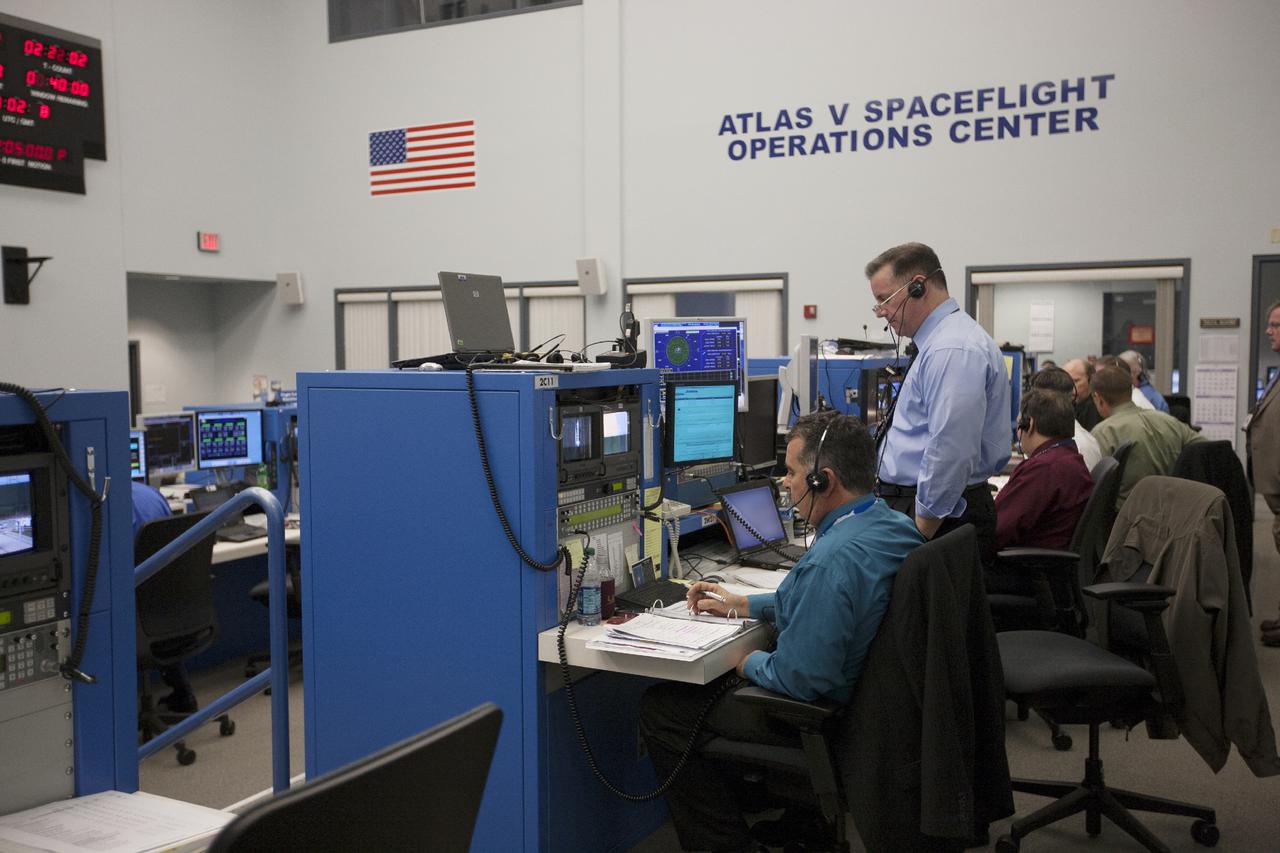
CAPE CANAVERAL, Fla. – During preparations for the launch of NASA's Tracking and Data Relay Satellite, or TDRS-L, spacecraft, astronauts Eric Boe, left, and Bob Behnken discuss the status of the countdown with NASA managers in Cape Canaveral Air Force Station's Atlas V Spaceflight Operations Center. The TDRS-L spacecraft is the second of three new satellites designed to ensure vital operational continuity for NASA by expanding the lifespan of the Tracking and Data Relay Satellite System TDRSS fleet, which consists of eight satellites in geosynchronous orbit. The spacecraft provide tracking, telemetry, command and high bandwidth data return services for numerous science and human exploration missions orbiting Earth. These include NASA's Hubble Space Telescope and the International Space Station. TDRS-L has a high-performance solar panel designed for more spacecraft power to meet the growing S-band communications requirements. TDRSS is one of NASA Space Communication and Navigation’s SCaN three networks providing space communications to NASA’s missions. For more information more about TDRS-L, visit: http:__www.nasa.gov_tdrs To learn more about SCaN, visit: www.nasa.gov_scan Photo credit: NASA_Kim Shiflett
VANDENBERG AFB, Calif. -- At the Astrotech processing facility at Vandenberg Air Force Base, Calif., the payload fairing arrives for the NASA's Landsat Data Continuity Mission. The Landsat Data Continuity Mission LDCM is the future of Landsat satellites. It will continue to obtain valuable data and imagery to be used in agriculture, education, business, science, and government. The Landsat Program provides repetitive acquisition of high resolution multispectral data of the Earth's surface on a global basis. The data from the Landsat spacecraft constitute the longest record of the Earth's continental surfaces as seen from space. It is a record unmatched in quality, detail, coverage, and value. Liftoff is planned for Feb. 11, 2013 aboard a United Launch Alliance Atlas V rocket. For more information, visit: http:__www.nasa.gov_mission_pages_landsat_main_index.html Photo credit: NASA
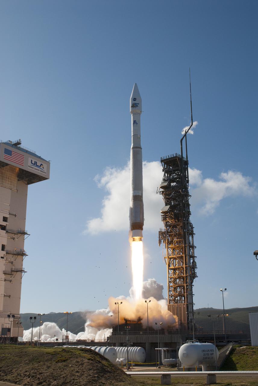
VANDENBERG AFB, Calif. -- The Landsat Data Continuity Mission spacecraft lifts off at 1:02 p.m. EST, 10:02 a.m. PST) atop a United Launch Alliance Atlas V rocket from Space Launch Complex 3 at California's Vandenberg Air Force Base. The Landsat Data Continuity Mission LDCM is the future of Landsat satellites. It will continue to obtain valuable data and imagery to be used in agriculture, education, business, science, and government. The Landsat Program provides repetitive acquisition of high resolution multispectral data of the Earth's surface on a global basis. The data from the Landsat spacecraft constitute the longest record of the Earth's continental surfaces as seen from space. It is a record unmatched in quality, detail, coverage, and value. For more information, visit: http:__www.nasa.gov_mission_pages_landsat_main_index.html Photo credit: NASA_Kim Shiflett
VANDENBERG AFB, Calif. -- At Vandenberg Air Force Base, Calif., the gantry at Space Launch Complex 3E rolls back from NASA's Landsat Data Continuity Mission, or LDCM, satellite mounted atop a United Launch Alliance Atlas V rocket. The Landsat Data Continuity Mission LDCM is the future of Landsat satellites. It will continue to obtain valuable data and imagery to be used in agriculture, education, business, science, and government. The Landsat Program provides repetitive acquisition of high resolution multispectral data of the Earth's surface on a global basis. The data from the Landsat spacecraft constitute the longest record of the Earth's continental surfaces as seen from space. It is a record unmatched in quality, detail, coverage, and value. Liftoff is planned for Feb. 11, 2013 aboard a United Launch Alliance Atlas V rocket. For more information, visit: http:__www.nasa.gov_mission_pages_landsat_main_index.html Photo credit: NASA_Kim Shiflett
CAPE CANAVERAL, Fla. –- Enclosed in its payload fairing, NASA's Tracking and Data Relay Satellite, TDRS-K, is being prepare for the lift that will place it atop a United Launch Alliance Atlas V rocket at Cape Canaveral Air Force Station's Space Launch Complex 41. Liftoff for the TDRS-K is planned for January 30, 2013. The TDRS-K spacecraft is part of the next-generation series in the Tracking and Data Relay Satellite System, a constellation of space-based communication satellites providing tracking, telemetry, command and high-bandwidth data return services. For more information, visit http:__www.nasa.gov_mission_pages_tdrs_index.html Photo credit: NASA_ Glenn Bension
TITUSVILLE, Fla. - Inside the Astrotech payload processing facility in Titusville, Fla. near NASA’s Kennedy Space Center, the Tracking and Data Relay Satellite, TDRS-K, has been encapsulated in its payload fairing. Technicians are completing final checkouts prior to the spacecraft being transported to Space Launch Complex 41 at Cape Canaveral Air Force Station. Liftoff for the TDRS-K is planned for January 30, 2013. The TDRS-K spacecraft is part of the next-generation series in the Tracking and Data Relay Satellite System, a constellation of space-based communication satellites providing tracking, telemetry, command and high-bandwidth data return services. For more information, visit http:__www.nasa.gov_mission_pages_tdrs_index.html Photo credit: NASA_Kim Shiflett
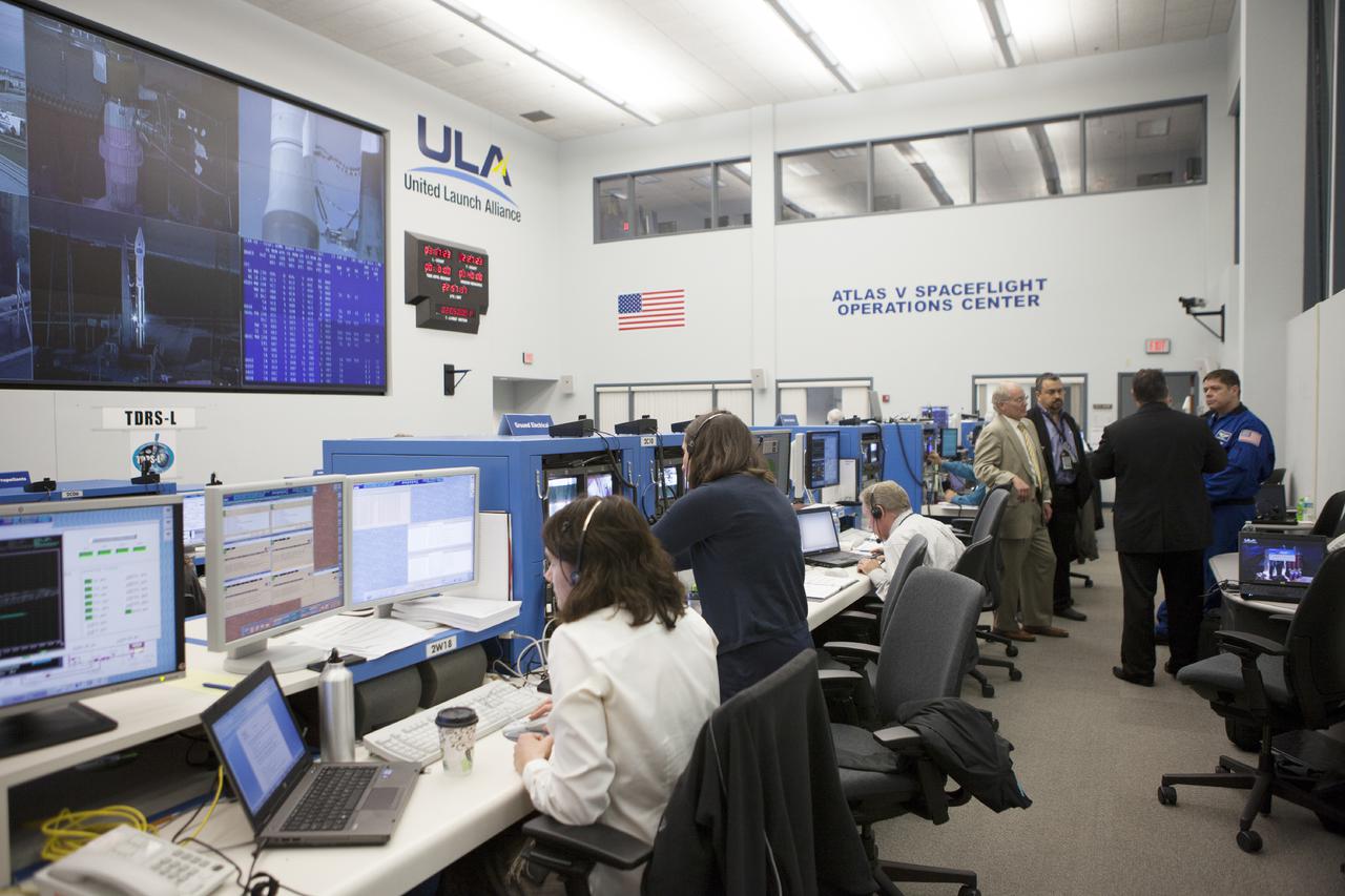
CAPE CANAVERAL, Fla. – At Cape Canaveral Air Force Station's Atlas V Spaceflight Operations Center NASA and contractor managers and engineers monitor progress of the countdown for the launch the agency's Tracking and Data Relay Satellite, or TDRS-L, spacecraft atop a United Launch Alliance Atlas V rocket. The TDRS-L spacecraft is the second of three new satellites designed to ensure vital operational continuity for NASA by expanding the lifespan of the Tracking and Data Relay Satellite System TDRSS fleet, which consists of eight satellites in geosynchronous orbit. The spacecraft provide tracking, telemetry, command and high bandwidth data return services for numerous science and human exploration missions orbiting Earth. These include NASA's Hubble Space Telescope and the International Space Station. TDRS-L has a high-performance solar panel designed for more spacecraft power to meet the growing S-band communications requirements. TDRSS is one of NASA Space Communication and Navigation’s SCaN three networks providing space communications to NASA’s missions. For more information more about TDRS-L, visit: http:__www.nasa.gov_tdrs To learn more about SCaN, visit: www.nasa.gov_scan Photo credit: NASA_Kim Shiflett
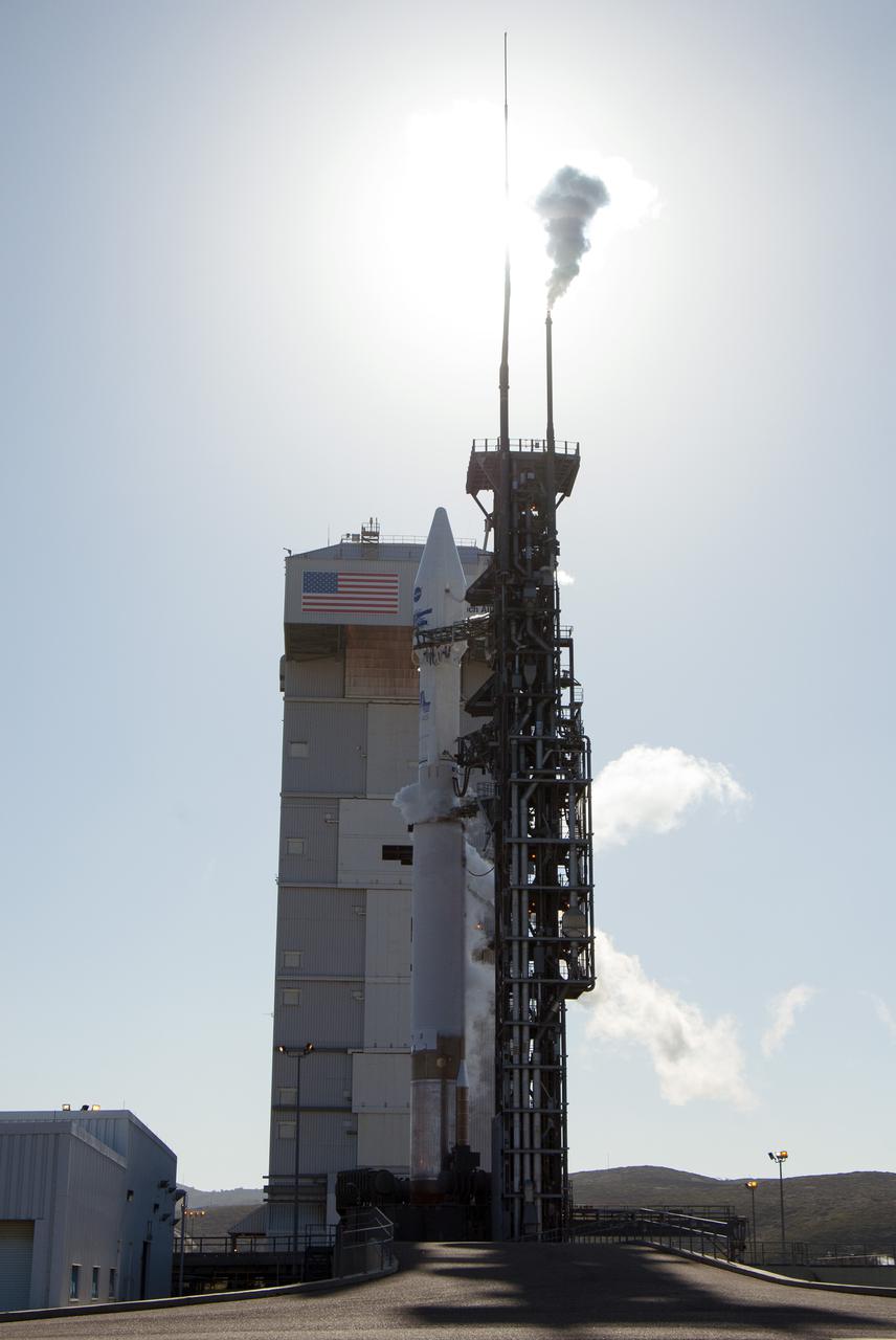
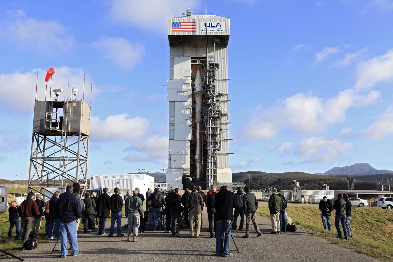
The Landsat Data Continuity Mission spacecraft is poised for lift off atop a United Launch Alliance Atlas V rocket from Space Launch Complex 3 at California's Vandenberg Air Force Base. The Landsat Data Continuity Mission LDCM is the future of Landsat satellites. It will continue to obtain valuable data and imagery to be used in agriculture, education, business, science, and government. The Landsat Program provides repetitive acquisition of high resolution multispectral data of the Earth's surface on a global basis. The data from the Landsat spacecraft constitute the longest record of the Earth's continental surfaces as seen from space. It is a record unmatched in quality, detail, coverage, and value. For more information, visit: http:__www.nasa.gov_mission_pages_landsat_main_index.html Photo credit: NASA_Kim Shiflett

VANDENBERG AFB, Calif. -- During a news conference at Vandenberg Air Force Base, Calif. prior to the launch of NASA's Landsat Data Continuity Mission, or LDCM, media representative heard from Dr. Jim Irons, LDCM project scientist from NASA's Goddard Space Flight Center, Dr. Thomas Loveland, senior scientist and co-chair of the Landsat Science Team U.S. Geological Survey Earth Resources Observation and Science Center, and Kass Green, Landsat scientist and president of Kass Green and Associates. The Landsat Data Continuity Mission LDCM is the future of Landsat satellites. It will continue to obtain valuable data and imagery to be used in agriculture, education, business, science, and government. The Landsat Program provides repetitive acquisition of high resolution multispectral data of the Earth's surface on a global basis. The data from the Landsat spacecraft constitute the longest record of the Earth's continental surfaces as seen from space. It is a record unmatched in quality, detail, coverage, and value. Liftoff is planned for Feb. 11, 2013 aboard a United Launch Alliance Atlas V rocket. For more information, visit: http:__www.nasa.gov_mission_pages_landsat_main_index.html Photo credit: NASA_Kim Shiflett
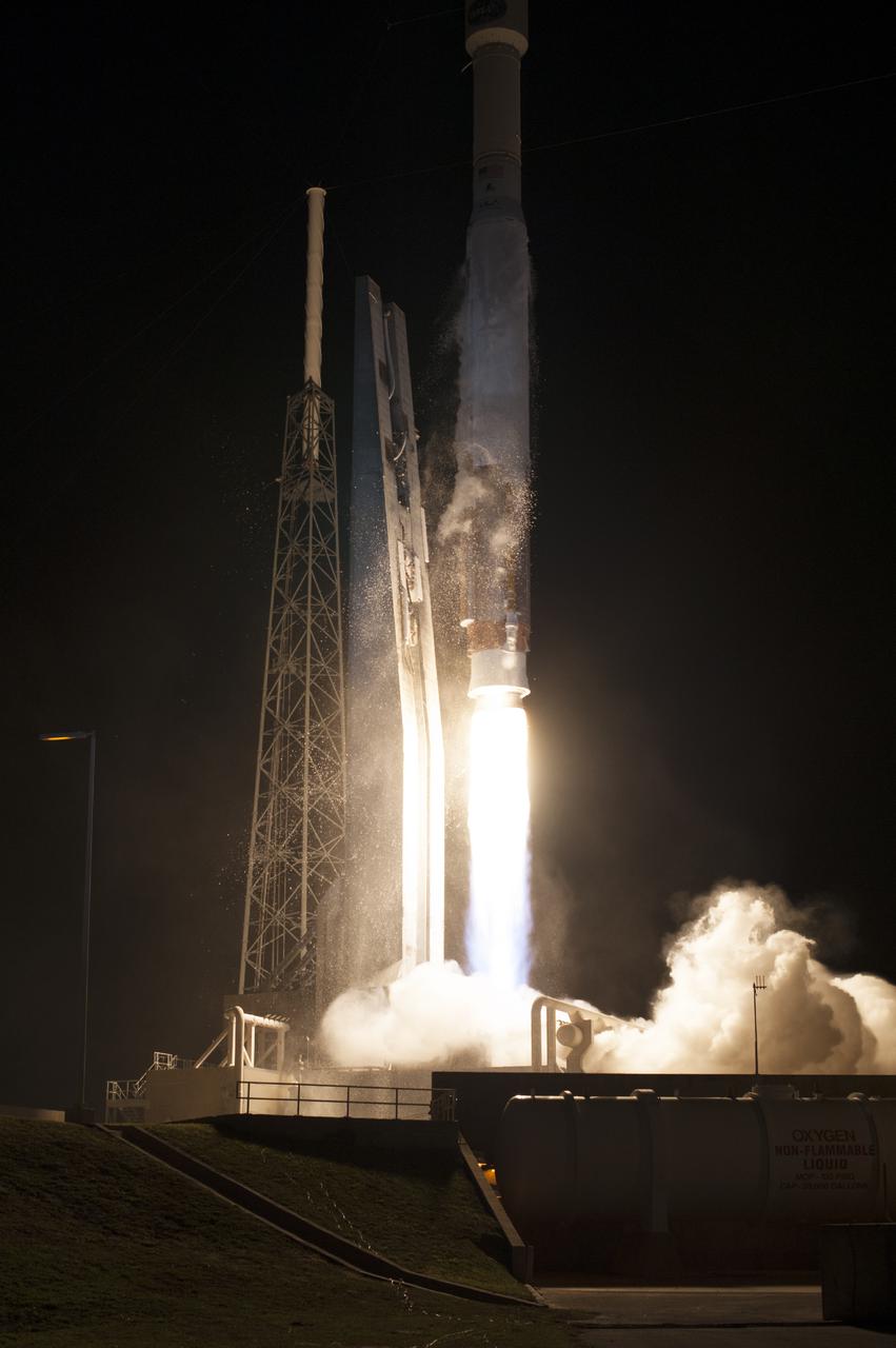
CAPE CANAVERAL, Fla. – The United Launch Alliance Atlas V rocket lifts off from Space Launch Complex 41 at Cape Canaveral Air Force Station carrying NASA's Tracking and Data Relay Satellite, or TDRS-L, spacecraft to Earth orbit. Liftoff was at 9:33 p.m. EST. The TDRS-L spacecraft is the second of three new satellites designed to ensure vital operational continuity for NASA by expanding the lifespan of the Tracking and Data Relay Satellite System TDRSS fleet, which consists of eight satellites in geosynchronous orbit. The spacecraft provide tracking, telemetry, command and high bandwidth data return services for numerous science and human exploration missions orbiting Earth. These include NASA's Hubble Space Telescope and the International Space Station. TDRS-L has a high-performance solar panel designed for more spacecraft power to meet the growing S-band communications requirements. TDRSS is one of NASA Space Communication and Navigation’s SCaN three networks providing space communications to NASA’s missions. For more information more about TDRS-L, visit: http:__www.nasa.gov_tdrs To learn more about SCaN, visit: www.nasa.gov_scan Photo credit: NASA_Tony Gray and Sandy Joseph
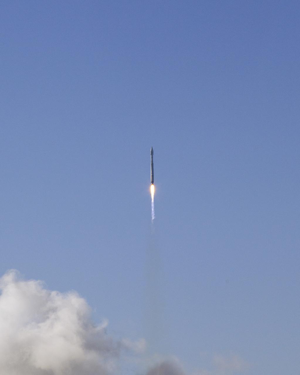
VANDENBERG AFB, Calif. -- The Landsat Data Continuity Mission spacecraft lifted off at 1:02 p.m. EST, 10:02 a.m. PST) atop a United Launch Alliance Atlas V rocket from Space Launch Complex 3 at California's Vandenberg Air Force Base. The Landsat Data Continuity Mission LDCM is the future of Landsat satellites. It will continue to obtain valuable data and imagery to be used in agriculture, education, business, science, and government. The Landsat Program provides repetitive acquisition of high resolution multispectral data of the Earth's surface on a global basis. The data from the Landsat spacecraft constitute the longest record of the Earth's continental surfaces as seen from space. It is a record unmatched in quality, detail, coverage, and value. For more information, visit: http:__www.nasa.gov_mission_pages_landsat_main_index.html Photo credit: NASA_Kim Shiflett
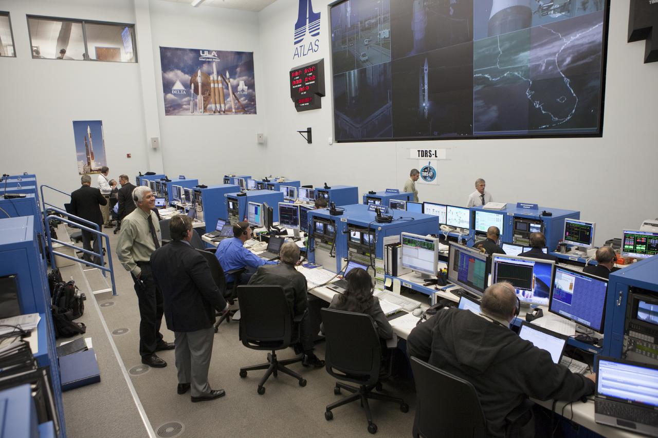
CAPE CANAVERAL, Fla. – At Cape Canaveral Air Force Station's Atlas V Spaceflight Operations Center NASA and contractor managers and engineers monitor progress of the countdown for the launch the agency's Tracking and Data Relay Satellite, or TDRS-L, spacecraft atop a United Launch Alliance Atlas V rocket. The TDRS-L spacecraft is the second of three new satellites designed to ensure vital operational continuity for NASA by expanding the lifespan of the Tracking and Data Relay Satellite System TDRSS fleet, which consists of eight satellites in geosynchronous orbit. The spacecraft provide tracking, telemetry, command and high bandwidth data return services for numerous science and human exploration missions orbiting Earth. These include NASA's Hubble Space Telescope and the International Space Station. TDRS-L has a high-performance solar panel designed for more spacecraft power to meet the growing S-band communications requirements. TDRSS is one of NASA Space Communication and Navigation’s SCaN three networks providing space communications to NASA’s missions. For more information more about TDRS-L, visit: http:__www.nasa.gov_tdrs To learn more about SCaN, visit: www.nasa.gov_scan Photo credit: NASA_Kim Shiflett

CAPE CANAVERAL, Fla. – The United Launch Alliance Atlas V rocket lifts off from Space Launch Complex 41 at Cape Canaveral Air Force Station carrying NASA's Tracking and Data Relay Satellite, or TDRS-L, spacecraft to Earth orbit. Liftoff was at 9:33 p.m. EST. The TDRS-L spacecraft is the second of three new satellites designed to ensure vital operational continuity for NASA by expanding the lifespan of the Tracking and Data Relay Satellite System TDRSS fleet, which consists of eight satellites in geosynchronous orbit. The spacecraft provide tracking, telemetry, command and high bandwidth data return services for numerous science and human exploration missions orbiting Earth. These include NASA's Hubble Space Telescope and the International Space Station. TDRS-L has a high-performance solar panel designed for more spacecraft power to meet the growing S-band communications requirements. TDRSS is one of NASA Space Communication and Navigation’s SCaN three networks providing space communications to NASA’s missions. For more information more about TDRS-L, visit: http:__www.nasa.gov_tdrs To learn more about SCaN, visit: www.nasa.gov_scan Photo credit: NASA_Tony Gray and Sandy Joseph
CAPE CANAVERAL, Fla. –- Enclosed in its payload fairing, NASA's Tracking and Data Relay Satellite, TDRS-K, is being moved into position for placement atop a United Launch Alliance Atlas V rocket at Cape Canaveral Air Force Station's Space Launch Complex 41. Liftoff for the TDRS-K is planned for January 30, 2013. The TDRS-K spacecraft is part of the next-generation series in the Tracking and Data Relay Satellite System, a constellation of space-based communication satellites providing tracking, telemetry, command and high-bandwidth data return services. For more information, visit http:__www.nasa.gov_mission_pages_tdrs_index.html Photo credit: NASA_ Glenn Bension
VANDENBERG AFB, Calif. -- At Space Launch Complex 3E at Vandenberg Air Force Base, Michael Freilich, director of the Earth Science Division, Science Mission Directorate, at NASA Headquarters, discuss the Landsat Data Continuity Mission, or LDCM, satellite mission with NASA social media followers. Looking on, to the right, is NASA Administrator Charles Bolden, left, and Anne Castle, assistant secretary for Water and Science, U.S. Department of the Interior. The Landsat Data Continuity Mission LDCM is the future of Landsat satellites. It will continue to obtain valuable data and imagery to be used in agriculture, education, business, science, and government. The Landsat Program provides repetitive acquisition of high resolution multispectral data of the Earth's surface on a global basis. The data from the Landsat spacecraft constitute the longest record of the Earth's continental surfaces as seen from space. It is a record unmatched in quality, detail, coverage, and value. Liftoff is planned for Feb. 11, 2013 aboard a United Launch Alliance Atlas V rocket. For more information, visit: http:__www.nasa.gov_mission_pages_landsat_main_index.html Photo credit: NASA_Kim Shiflett
CAPE CANAVERAL, Fla. –- Enclosed in its payload fairing, NASA's Tracking and Data Relay Satellite, TDRS-K, , arrives at Cape Canaveral Air Force Station's Space Launch Complex 41. The spacecraft will now be lifted into position atop a United Launch Alliance Atlas V rocket. Liftoff for the TDRS-K is planned for January 30, 2013. The TDRS-K spacecraft is part of the next-generation series in the Tracking and Data Relay Satellite System, a constellation of space-based communication satellites providing tracking, telemetry, command and high-bandwidth data return services. For more information, visit http:__www.nasa.gov_mission_pages_tdrs_index.html Photo credit: NASA_ Glenn Bension

VANDENBERG AFB, Calif. -- At Vandenberg Air Force Base, Calif., the gantry at Space Launch Complex 3E rolls back from NASA's Landsat Data Continuity Mission, or LDCM, satellite mounted atop a United Launch Alliance Atlas V rocket. The Landsat Data Continuity Mission LDCM is the future of Landsat satellites. It will continue to obtain valuable data and imagery to be used in agriculture, education, business, science, and government. The Landsat Program provides repetitive acquisition of high resolution multispectral data of the Earth's surface on a global basis. The data from the Landsat spacecraft constitute the longest record of the Earth's continental surfaces as seen from space. It is a record unmatched in quality, detail, coverage, and value. Liftoff is planned for Feb. 11, 2013 aboard a United Launch Alliance Atlas V rocket. For more information, visit: http:__www.nasa.gov_mission_pages_landsat_main_index.html Photo credit: NASA_Kim Shiflett
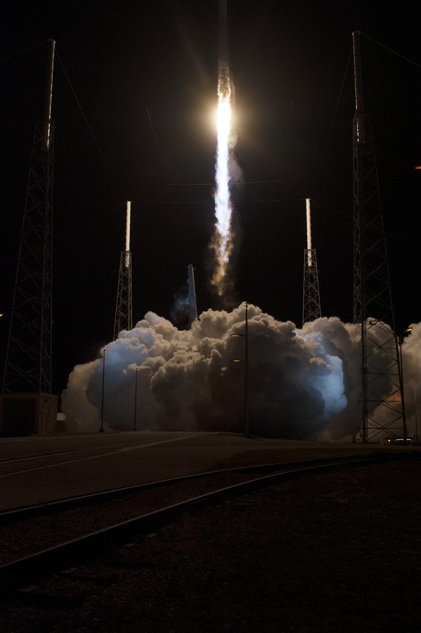
CAPE CANAVERAL, Fla. – The United Launch Alliance Atlas V rocket lifts off from Space Launch Complex 41 at Cape Canaveral Air Force Station carrying NASA's Tracking and Data Relay Satellite, or TDRS-L, spacecraft to Earth orbit. Liftoff was at 9:33 p.m. EST. The TDRS-L spacecraft is the second of three new satellites designed to ensure vital operational continuity for NASA by expanding the lifespan of the Tracking and Data Relay Satellite System TDRSS fleet, which consists of eight satellites in geosynchronous orbit. The spacecraft provide tracking, telemetry, command and high bandwidth data return services for numerous science and human exploration missions orbiting Earth. These include NASA's Hubble Space Telescope and the International Space Station. TDRS-L has a high-performance solar panel designed for more spacecraft power to meet the growing S-band communications requirements. TDRSS is one of NASA Space Communication and Navigation’s SCaN three networks providing space communications to NASA’s missions. For more information more about TDRS-L, visit: http:__www.nasa.gov_tdrs To learn more about SCaN, visit: www.nasa.gov_scan Photo credit: NASA_Tony Gray and Sandy Joseph
VANDENBERG AFB, Calif. -- At Vandenberg Air Force Base, Calif., the gantry at Space Launch Complex 3E rolls back from NASA's Landsat Data Continuity Mission, or LDCM, satellite mounted atop a United Launch Alliance Atlas V rocket. The Landsat Data Continuity Mission LDCM is the future of Landsat satellites. It will continue to obtain valuable data and imagery to be used in agriculture, education, business, science, and government. The Landsat Program provides repetitive acquisition of high resolution multispectral data of the Earth's surface on a global basis. The data from the Landsat spacecraft constitute the longest record of the Earth's continental surfaces as seen from space. It is a record unmatched in quality, detail, coverage, and value. Liftoff is planned for Feb. 11, 2013 aboard a United Launch Alliance Atlas V rocket. For more information, visit: http:__www.nasa.gov_mission_pages_landsat_main_index.html Photo credit: NASA_Kim Shiflett

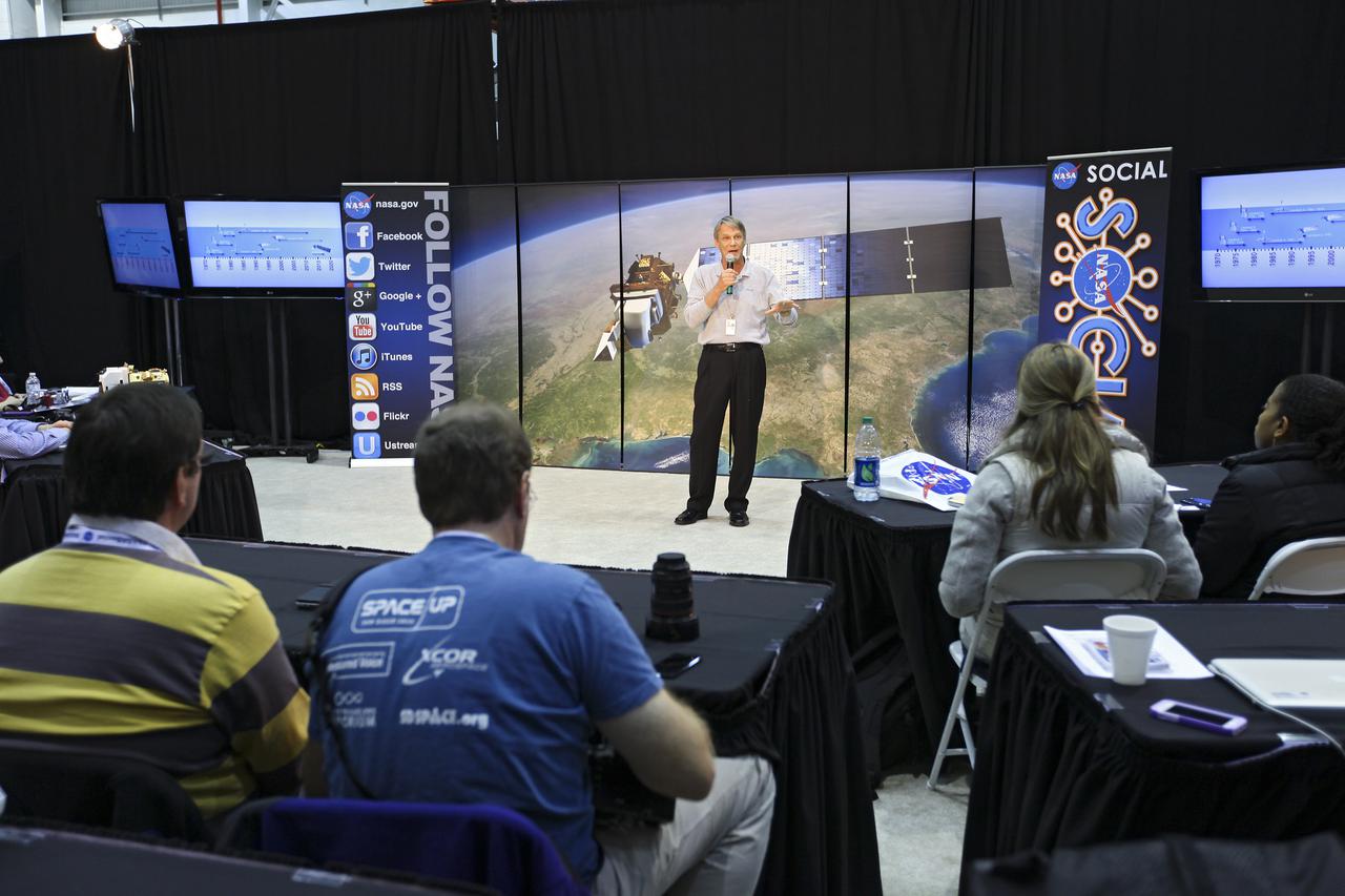
VANDENBERG AFB, Calif. -- Speaking to NASA social media followers at Vandenberg Air Force Base, Calif., prior to the launch of the Landsat Data Continuity Mission satellite, from the left, are John Yembrick, social media manager at NASA, Dr. Thomas Loveland, senior scientist and co-chair of the Landsat Science Team U.S. Geological Survey Earth Resources Observation and Science Center, and Dr. Jim Irons, Landsat Data Continuity Mission project scientist from NASA's Goddard Space Flight Center. The Landsat Data Continuity Mission LDCM is the future of Landsat satellites. It will continue to obtain valuable data and imagery to be used in agriculture, education, business, science, and government. The Landsat Program provides repetitive acquisition of high resolution multispectral data of the Earth's surface on a global basis. The data from the Landsat spacecraft constitute the longest record of the Earth's continental surfaces as seen from space. It is a record unmatched in quality, detail, coverage, and value. Liftoff is planned for Feb. 11, 2013 aboard a United Launch Alliance Atlas V rocket. For more information, visit: http:__www.nasa.gov_mission_pages_landsat_main_index.html Photo credit: NASA_Kim Shiflett
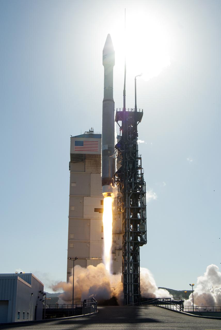
VANDENBERG AFB, Calif. -- The Landsat Data Continuity Mission spacecraft lifts off at 1:02 p.m. EST, 10:02 a.m. PST) atop a United Launch Alliance Atlas V rocket from Space Launch Complex 3 at California's Vandenberg Air Force Base. The Landsat Data Continuity Mission LDCM is the future of Landsat satellites. It will continue to obtain valuable data and imagery to be used in agriculture, education, business, science, and government. The Landsat Program provides repetitive acquisition of high resolution multispectral data of the Earth's surface on a global basis. The data from the Landsat spacecraft constitute the longest record of the Earth's continental surfaces as seen from space. It is a record unmatched in quality, detail, coverage, and value. For more information, visit: http:__www.nasa.gov_mission_pages_landsat_main_index.html Photo credit: NASA_Kim Shiflett

CAPE CANAVERAL, Fla. –- At a news conference, NASA and United Launch Alliance officials discussed preparations for the planned launch of NASA's Tracking and Data Relay Satellite, TDRS-K, atop an Atlas V rocket. Among those participating in the briefing is Jeffrey Gramling, NASA TDRS-K project manager, Goddard Space Flight Center in Greenbelt, Md. Liftoff for the TDRS-K is planned for Jan. 30, 2013. The TDRS-K spacecraft is part of the next-generation series in the Tracking and Data Relay Satellite System, a constellation of space-based communication satellites providing tracking, telemetry, command and high-bandwidth data return services. For more information, visit http:__www.nasa.gov_mission_pages_tdrs_index.html Photo credit: NASA_Kim Shiflett
VANDENBERG AFB, Calif. -- At Space Launch Complex 3E at Vandenberg Air Force Base, Kennedy Space Center Director Bob Cabana discusses the Landsat Data Continuity Mission, or LDCM, satellite mission with NASA social media followers. The Landsat Data Continuity Mission LDCM is the future of Landsat satellites. It will continue to obtain valuable data and imagery to be used in agriculture, education, business, science, and government. The Landsat Program provides repetitive acquisition of high resolution multispectral data of the Earth's surface on a global basis. The data from the Landsat spacecraft constitute the longest record of the Earth's continental surfaces as seen from space. It is a record unmatched in quality, detail, coverage, and value. Liftoff is planned for Feb. 11, 2013 aboard a United Launch Alliance Atlas V rocket. For more information, visit: http:__www.nasa.gov_mission_pages_landsat_main_index.html Photo credit: NASA_Kim Shiflett
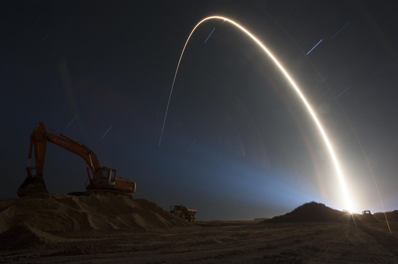
CAPE CANAVERAL, Fla. – In this time lapse photograph, a United Launch Alliance Atlas V rocket lifts off from Space Launch Complex 41 illuminating a beach restoration site at NASA's Kennedy Space Center in Florida. Liftoff was at 9:33 p.m. EST boosting the agency's Tracking and Data Relay Satellite, or TDRS-L, spacecraft to Earth orbit. The TDRS-L spacecraft is the second of three new satellites designed to ensure vital operational continuity for NASA by expanding the lifespan of the Tracking and Data Relay Satellite System TDRSS fleet, which consists of eight satellites in geosynchronous orbit. The spacecraft provide tracking, telemetry, command and high bandwidth data return services for numerous science and human exploration missions orbiting Earth. These include NASA's Hubble Space Telescope and the International Space Station. TDRS-L has a high-performance solar panel designed for more spacecraft power to meet the growing S-band communications requirements. TDRSS is one of NASA Space Communication and Navigation’s SCaN three networks providing space communications to NASA’s missions. For more information more about TDRS-L, visit: http:__www.nasa.gov_tdrs To learn more about SCaN, visit: www.nasa.gov_scan For more on beach restoration at Kennedy visit: http:__www.nasa.gov_centers_kennedy_about_sustainability_beach_erosion.html Photo credit: NASA_Tony Gray

CAPE CANAVERAL, Fla. – At Cape Canaveral Air Force Station's Atlas V Spaceflight Operations Center NASA and contractor managers and engineers monitor progress of the countdown for the launch the agency's Tracking and Data Relay Satellite, or TDRS-L, spacecraft atop a United Launch Alliance Atlas V rocket. The TDRS-L spacecraft is the second of three new satellites designed to ensure vital operational continuity for NASA by expanding the lifespan of the Tracking and Data Relay Satellite System TDRSS fleet, which consists of eight satellites in geosynchronous orbit. The spacecraft provide tracking, telemetry, command and high bandwidth data return services for numerous science and human exploration missions orbiting Earth. These include NASA's Hubble Space Telescope and the International Space Station. TDRS-L has a high-performance solar panel designed for more spacecraft power to meet the growing S-band communications requirements. TDRSS is one of NASA Space Communication and Navigation’s SCaN three networks providing space communications to NASA’s missions. For more information more about TDRS-L, visit: http:__www.nasa.gov_tdrs To learn more about SCaN, visit: www.nasa.gov_scan Photo credit: NASA_Kim Shiflett
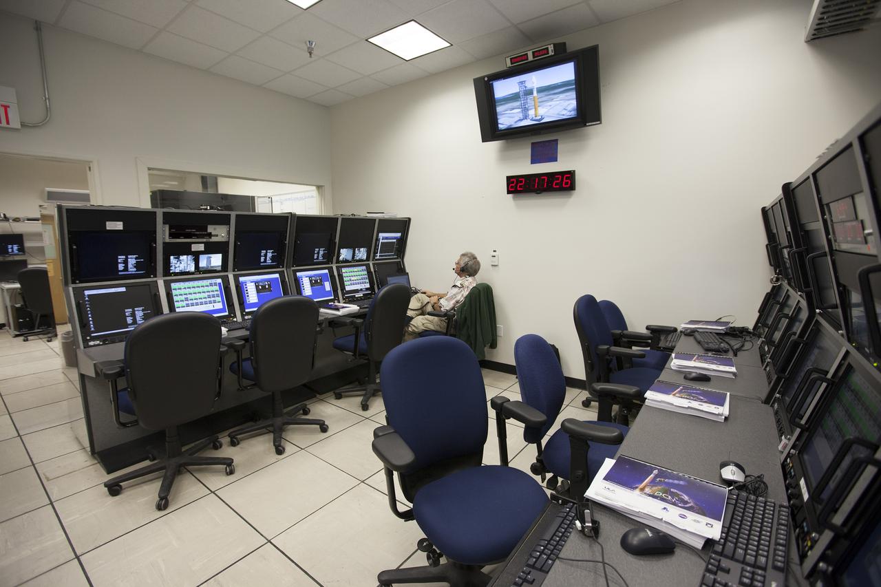
VANDENBERG AFB, Calif. -- From their positions in the telemetry laboratory at Vandenberg Air Force Base, engineers and technicians monitor the countdown for a United Launch Alliance Atlas V with the Landsat Data Continuity Mission, or LDCM, satellite prior to liftoff. The Landsat Data Continuity Mission, or LDCM, is the future of Landsat satellites. It will continue to obtain valuable data and imagery to be used in agriculture, education, business, science, and government. The Landsat Program provides repetitive acquisition of high resolution multispectral data of the Earth's surface on a global basis. The data from the Landsat spacecraft constitute the longest record of the Earth's continental surfaces as seen from space. It is a record unmatched in quality, detail, coverage, and value. Liftoff is planned for Feb. 11, 2013 aboard a United Launch Alliance Atlas V rocket. For more information, visit: http:__www.nasa.gov_mission_pages_landsat_main_index.html Photo credit: NASA_ Kim Shiflett
CAPE CANAVERAL, Fla. – At Cape Canaveral Air Force Station's Atlas V Spaceflight Operations Center NASA and contractor managers and engineers monitor progress of the countdown for the launch the agency's Tracking and Data Relay Satellite, or TDRS-L, spacecraft atop a United Launch Alliance Atlas V rocket. The TDRS-L spacecraft is the second of three new satellites designed to ensure vital operational continuity for NASA by expanding the lifespan of the Tracking and Data Relay Satellite System TDRSS fleet, which consists of eight satellites in geosynchronous orbit. The spacecraft provide tracking, telemetry, command and high bandwidth data return services for numerous science and human exploration missions orbiting Earth. These include NASA's Hubble Space Telescope and the International Space Station. TDRS-L has a high-performance solar panel designed for more spacecraft power to meet the growing S-band communications requirements. TDRSS is one of NASA Space Communication and Navigation’s SCaN three networks providing space communications to NASA’s missions. For more information more about TDRS-L, visit: http:__www.nasa.gov_tdrs To learn more about SCaN, visit: www.nasa.gov_scan Photo credit: NASA_Kim Shiflett

VANDENBERG AFB, Calif. -- The payload fairing containing the Landsat Data Continuity Mission, or LDCM, spacecraft arrives at Space Launch Complex-3E at Vandenberg Air Force Base, Calif. where it will be hoisted atop a United Launch Alliance Atlas V for launch. The Landsat Data Continuity Mission LDCM is the future of Landsat satellites. It will continue to obtain valuable data and imagery to be used in agriculture, education, business, science, and government. The Landsat Program provides repetitive acquisition of high resolution multispectral data of the Earth's surface on a global basis. The data from the Landsat spacecraft constitute the longest record of the Earth's continental surfaces as seen from space. It is a record unmatched in quality, detail, coverage, and value. Liftoff is planned for Feb. 11, 2013 aboard a United Launch Alliance Atlas V rocket. For more information, visit: http:__www.nasa.gov_mission_pages_landsat_main_index.html Photo credit: NASA
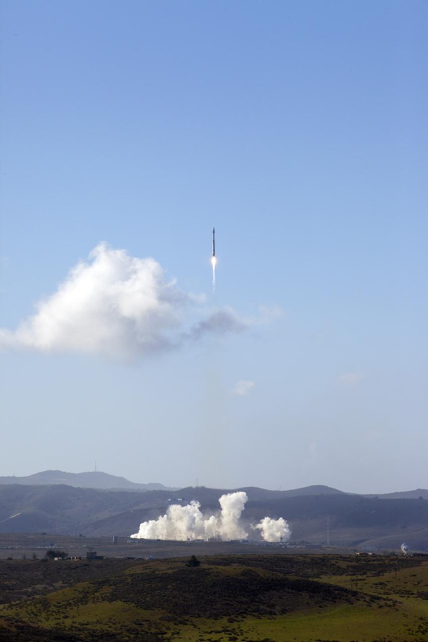
VANDENBERG AFB, Calif. -- The Landsat Data Continuity Mission spacecraft lifted off at 1:02 p.m. EST, 10:02 a.m. PST) atop a United Launch Alliance Atlas V rocket from Space Launch Complex 3 at California's Vandenberg Air Force Base. The Landsat Data Continuity Mission LDCM is the future of Landsat satellites. It will continue to obtain valuable data and imagery to be used in agriculture, education, business, science, and government. The Landsat Program provides repetitive acquisition of high resolution multispectral data of the Earth's surface on a global basis. The data from the Landsat spacecraft constitute the longest record of the Earth's continental surfaces as seen from space. It is a record unmatched in quality, detail, coverage, and value. For more information, visit: http:__www.nasa.gov_mission_pages_landsat_main_index.html Photo credit: NASA_Kim Shiflett
VANDENBERG AFB, Calif. -- The payload fairing containing the Landsat Data Continuity Mission, or LDCM, spacecraft arrives at Space Launch Complex-3E at Vandenberg Air Force Base, Calif. where it will be hoisted atop a United Launch Alliance Atlas V for launch. The Landsat Data Continuity Mission LDCM is the future of Landsat satellites. It will continue to obtain valuable data and imagery to be used in agriculture, education, business, science, and government. The Landsat Program provides repetitive acquisition of high resolution multispectral data of the Earth's surface on a global basis. The data from the Landsat spacecraft constitute the longest record of the Earth's continental surfaces as seen from space. It is a record unmatched in quality, detail, coverage, and value. Liftoff is planned for Feb. 11, 2013 aboard a United Launch Alliance Atlas V rocket. For more information, visit: http:__www.nasa.gov_mission_pages_landsat_main_index.html Photo credit: NASA
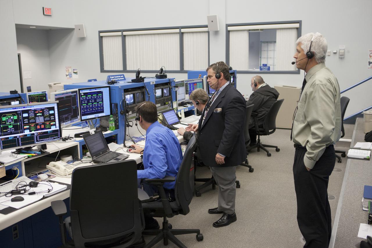
CAPE CANAVERAL, Fla. – At Cape Canaveral Air Force Station's Atlas V Spaceflight Operations Center NASA and contractor managers and engineers monitor progress of the countdown for the launch the agency's Tracking and Data Relay Satellite, or TDRS-L, spacecraft atop a United Launch Alliance Atlas V rocket. The TDRS-L spacecraft is the second of three new satellites designed to ensure vital operational continuity for NASA by expanding the lifespan of the Tracking and Data Relay Satellite System TDRSS fleet, which consists of eight satellites in geosynchronous orbit. The spacecraft provide tracking, telemetry, command and high bandwidth data return services for numerous science and human exploration missions orbiting Earth. These include NASA's Hubble Space Telescope and the International Space Station. TDRS-L has a high-performance solar panel designed for more spacecraft power to meet the growing S-band communications requirements. TDRSS is one of NASA Space Communication and Navigation’s SCaN three networks providing space communications to NASA’s missions. For more information more about TDRS-L, visit: http:__www.nasa.gov_tdrs To learn more about SCaN, visit: www.nasa.gov_scan Photo credit: NASA_Kim Shiflett
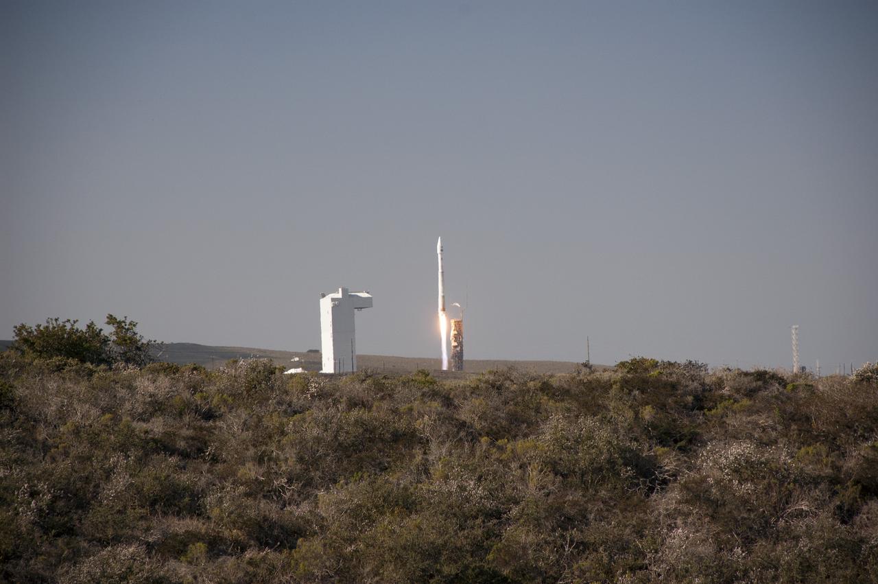
VANDENBERG AFB, Calif. -- The Landsat Data Continuity Mission spacecraft lifts off at 1:02 p.m. EST, 10:02 a.m. PST) atop a United Launch Alliance Atlas V rocket from Space Launch Complex 3 at California's Vandenberg Air Force Base. The Landsat Data Continuity Mission LDCM is the future of Landsat satellites. It will continue to obtain valuable data and imagery to be used in agriculture, education, business, science, and government. The Landsat Program provides repetitive acquisition of high resolution multispectral data of the Earth's surface on a global basis. The data from the Landsat spacecraft constitute the longest record of the Earth's continental surfaces as seen from space. It is a record unmatched in quality, detail, coverage, and value. For more information, visit: http:__www.nasa.gov_mission_pages_landsat_main_index.html Photo credit: NASA_Ben Smegelsky

CAPE CANAVERAL, Fla. –- At a news conference, NASA and United Launch Alliance officials discussed preparations for the planned launch of NASA's Tracking and Data Relay Satellite, TDRS-K, atop an Atlas V rocket. Among those participating in the briefing is Tim Dunn, NASA launch director at the Kennedy Space Center. Liftoff for the TDRS-K is planned for Jan. 30, 2013. The TDRS-K spacecraft is part of the next-generation series in the Tracking and Data Relay Satellite System, a constellation of space-based communication satellites providing tracking, telemetry, command and high-bandwidth data return services. For more information, visit http:__www.nasa.gov_mission_pages_tdrs_index.html Photo credit: NASA_Kim Shiflett
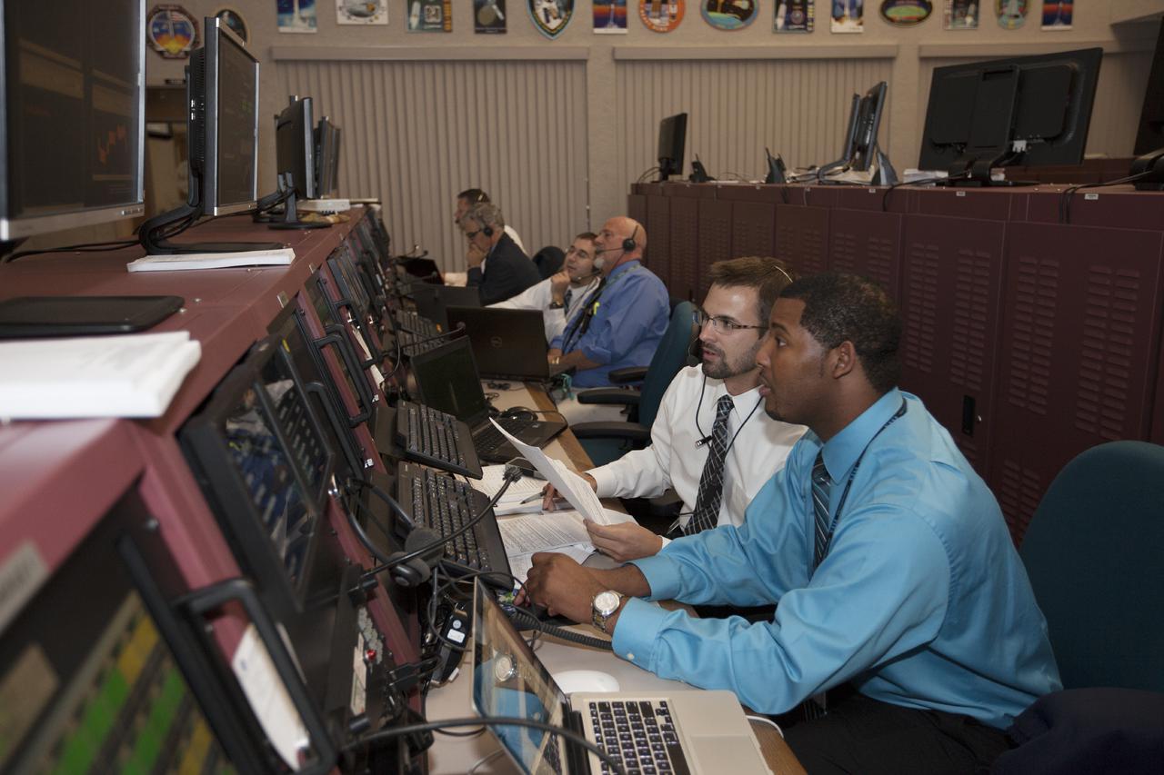
CAPE CANAVERAL, Fla. – In the Hangar AE Launch Vehicle Data Center at Cape Canaveral Air Force Station in Florida, NASA and contractor managers and engineers monitor progress of the countdown for the launch the agency's Tracking and Data Relay Satellite, or TDRS-L, spacecraft atop a United Launch Alliance Atlas V rocket. The TDRS-L spacecraft is the second of three new satellites designed to ensure vital operational continuity for NASA by expanding the lifespan of the Tracking and Data Relay Satellite System TDRSS fleet, which consists of eight satellites in geosynchronous orbit. The spacecraft provide tracking, telemetry, command and high bandwidth data return services for numerous science and human exploration missions orbiting Earth. These include NASA's Hubble Space Telescope and the International Space Station. TDRS-L has a high-performance solar panel designed for more spacecraft power to meet the growing S-band communications requirements. TDRSS is one of NASA Space Communication and Navigation’s SCaN three networks providing space communications to NASA’s missions. For more information more about TDRS-L, visit: http:__www.nasa.gov_tdrs To learn more about SCaN, visit: www.nasa.gov_scan Photo credit: NASA_Kim Shiflett
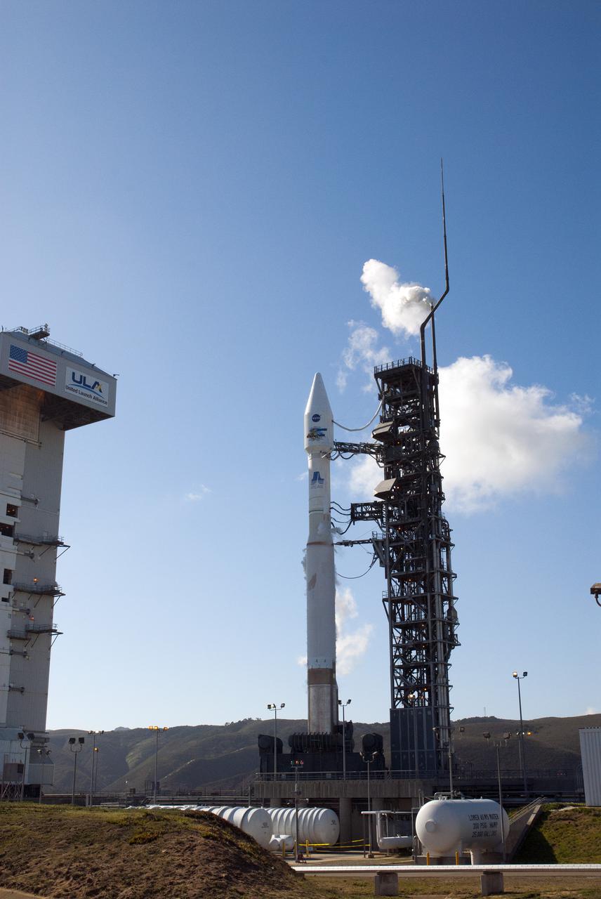
VANDENBERG AFB, Calif. -- The Landsat Data Continuity Mission spacecraft is poised for lift off atop a United Launch Alliance Atlas V rocket from Space Launch Complex 3 at California's Vandenberg Air Force Base. The Landsat Data Continuity Mission LDCM is the future of Landsat satellites. It will continue to obtain valuable data and imagery to be used in agriculture, education, business, science, and government. The Landsat Program provides repetitive acquisition of high resolution multispectral data of the Earth's surface on a global basis. The data from the Landsat spacecraft constitute the longest record of the Earth's continental surfaces as seen from space. It is a record unmatched in quality, detail, coverage, and value. For more information, visit: http:__www.nasa.gov_mission_pages_landsat_main_index.html Photo credit: NASA_Kim Shiflett
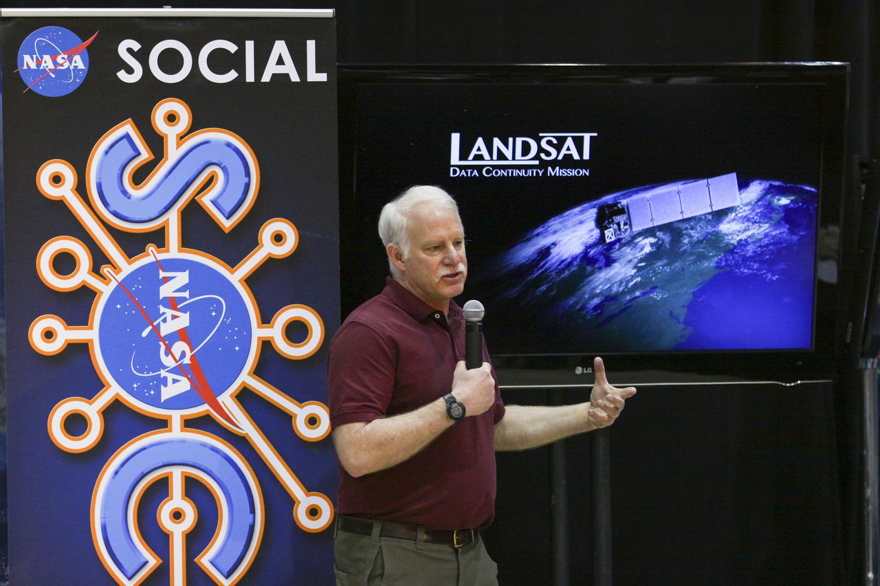
VANDENBERG AFB, Calif. -- Dr. Jim Irons, Landsat Data Continuity Mission project scientist from NASA's Goddard Space Flight Center, speaks to NASA social media followers at Vandenberg Air Force Base, Calif., prior to the launch of the LDCM satellite. The Landsat Data Continuity Mission LDCM is the future of Landsat satellites. It will continue to obtain valuable data and imagery to be used in agriculture, education, business, science, and government. The Landsat Program provides repetitive acquisition of high resolution multispectral data of the Earth's surface on a global basis. The data from the Landsat spacecraft constitute the longest record of the Earth's continental surfaces as seen from space. It is a record unmatched in quality, detail, coverage, and value. Liftoff is planned for Feb. 11, 2013 aboard a United Launch Alliance Atlas V rocket. For more information, visit: http:__www.nasa.gov_mission_pages_landsat_main_index.html Photo credit: NASA_Kim Shiflett
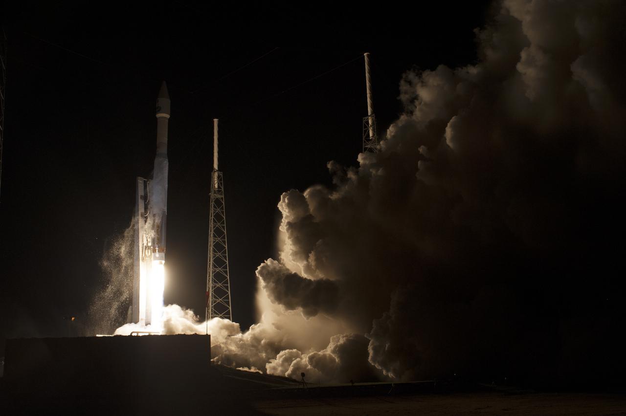
CAPE CANAVERAL, Fla. – The United Launch Alliance Atlas V rocket lifts off from Space Launch Complex 41 at Cape Canaveral Air Force Station carrying NASA's Tracking and Data Relay Satellite, or TDRS-L, spacecraft to Earth orbit. Liftoff was at 9:33 p.m. EST. The TDRS-L spacecraft is the second of three new satellites designed to ensure vital operational continuity for NASA by expanding the lifespan of the Tracking and Data Relay Satellite System TDRSS fleet, which consists of eight satellites in geosynchronous orbit. The spacecraft provide tracking, telemetry, command and high bandwidth data return services for numerous science and human exploration missions orbiting Earth. These include NASA's Hubble Space Telescope and the International Space Station. TDRS-L has a high-performance solar panel designed for more spacecraft power to meet the growing S-band communications requirements. TDRSS is one of NASA Space Communication and Navigation’s SCaN three networks providing space communications to NASA’s missions. For more information more about TDRS-L, visit: http:__www.nasa.gov_tdrs To learn more about SCaN, visit: www.nasa.gov_scan Photo credit: NASA_Tony Gray and Sandy Joseph
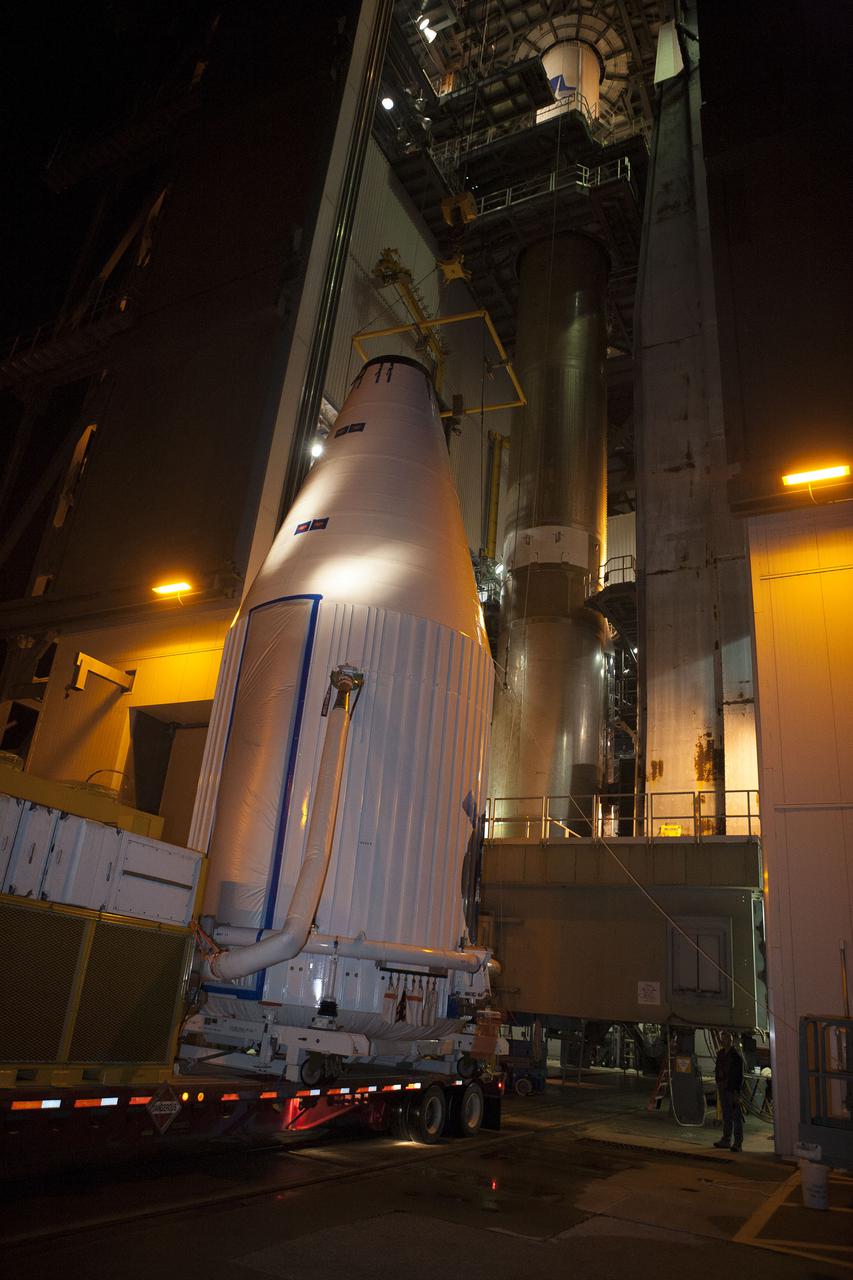
CAPE CANAVERAL, Fla. –- Enclosed in its payload fairing, NASA's Tracking and Data Relay Satellite, TDRS-K, , arrives at Cape Canaveral Air Force Station's Space Launch Complex 41. The spacecraft will now be lifted into position atop a United Launch Alliance Atlas V rocket. Liftoff for the TDRS-K is planned for January 30, 2013. The TDRS-K spacecraft is part of the next-generation series in the Tracking and Data Relay Satellite System, a constellation of space-based communication satellites providing tracking, telemetry, command and high-bandwidth data return services. For more information, visit http:__www.nasa.gov_mission_pages_tdrs_index.html Photo credit: NASA_ Glenn Bension
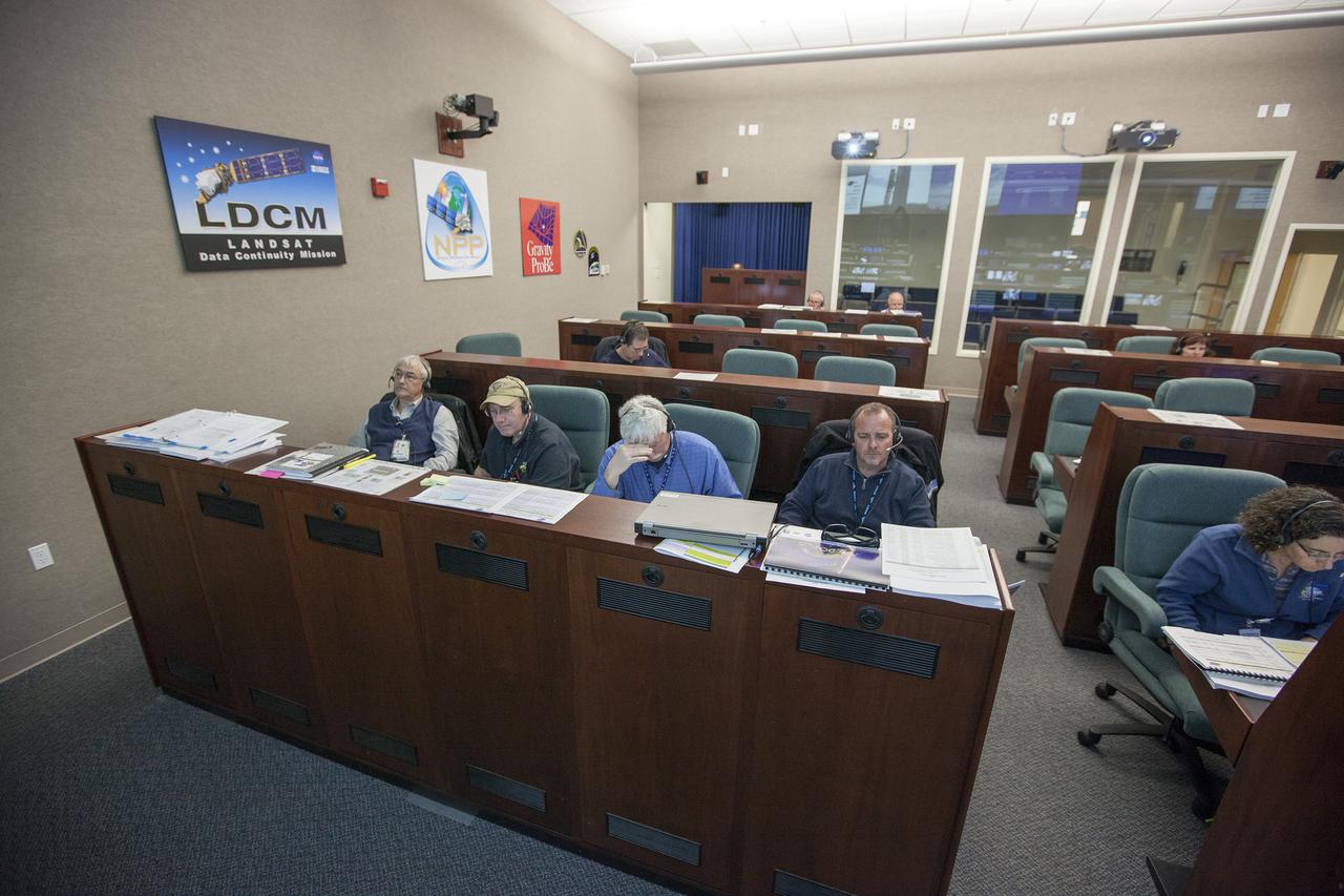
VANDENBERG AFB, Calif. -- From their consoles in the Mission Director's Center at Vandenberg Air Force Base, launch controllers monitor the countdown for a United Launch Alliance Atlas V with the Landsat Data Continuity Mission, or LDCM, satellite prior to liftoff. The Landsat Data Continuity Mission, or LDCM, is the future of Landsat satellites. It will continue to obtain valuable data and imagery to be used in agriculture, education, business, science, and government. The Landsat Program provides repetitive acquisition of high resolution multispectral data of the Earth's surface on a global basis. The data from the Landsat spacecraft constitute the longest record of the Earth's continental surfaces as seen from space. It is a record unmatched in quality, detail, coverage, and value. Liftoff is planned for Feb. 11, 2013 aboard a United Launch Alliance Atlas V rocket. For more information, visit: http:__www.nasa.gov_mission_pages_landsat_main_index.html Photo credit: NASA_ Kim Shiflett
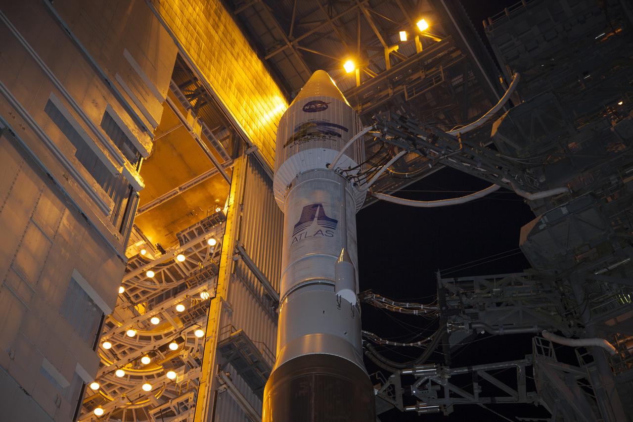
VANDENBERG AFB, Calif. -- At Vandenberg Air Force Base, Calif., the gantry at Space Launch Complex 3E rolls back from NASA's Landsat Data Continuity Mission, or LDCM, satellite mounted atop a United Launch Alliance Atlas V rocket. The Landsat Data Continuity Mission LDCM is the future of Landsat satellites. It will continue to obtain valuable data and imagery to be used in agriculture, education, business, science, and government. The Landsat Program provides repetitive acquisition of high resolution multispectral data of the Earth's surface on a global basis. The data from the Landsat spacecraft constitute the longest record of the Earth's continental surfaces as seen from space. It is a record unmatched in quality, detail, coverage, and value. Liftoff is planned for Feb. 11, 2013 aboard a United Launch Alliance Atlas V rocket. For more information, visit: http:__www.nasa.gov_mission_pages_landsat_main_index.html Photo credit: NASA_Kim Shiflett
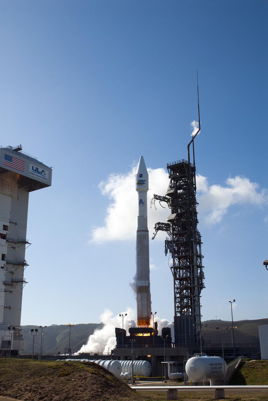
VANDENBERG AFB, Calif. -- The Landsat Data Continuity Mission spacecraft lifts off at 1:02 p.m. EST, 10:02 a.m. PST) atop a United Launch Alliance Atlas V rocket from Space Launch Complex 3 at California's Vandenberg Air Force Base. The Landsat Data Continuity Mission LDCM is the future of Landsat satellites. It will continue to obtain valuable data and imagery to be used in agriculture, education, business, science, and government. The Landsat Program provides repetitive acquisition of high resolution multispectral data of the Earth's surface on a global basis. The data from the Landsat spacecraft constitute the longest record of the Earth's continental surfaces as seen from space. It is a record unmatched in quality, detail, coverage, and value. For more information, visit: http:__www.nasa.gov_mission_pages_landsat_main_index.html Photo credit: NASA_Kim Shiflett
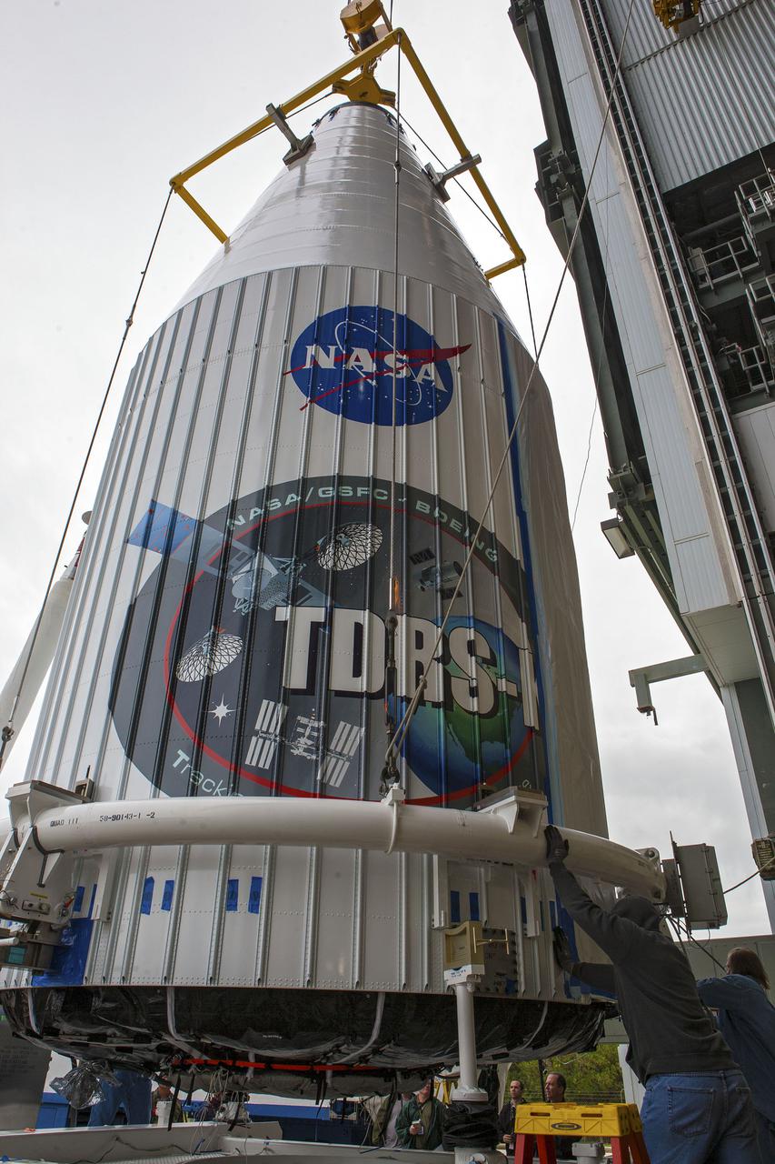
CAPE CANAVERAL, Fla. –- Enclosed in its payload fairing, NASA's Tracking and Data Relay Satellite, TDRS-K, is being prepare for the lift that will place it atop a United Launch Alliance Atlas V rocket at Cape Canaveral Air Force Station's Space Launch Complex 41. Liftoff for the TDRS-K is planned for January 30, 2013. The TDRS-K spacecraft is part of the next-generation series in the Tracking and Data Relay Satellite System, a constellation of space-based communication satellites providing tracking, telemetry, command and high-bandwidth data return services. For more information, visit http:__www.nasa.gov_mission_pages_tdrs_index.html Photo credit: NASA_ Glenn Bension
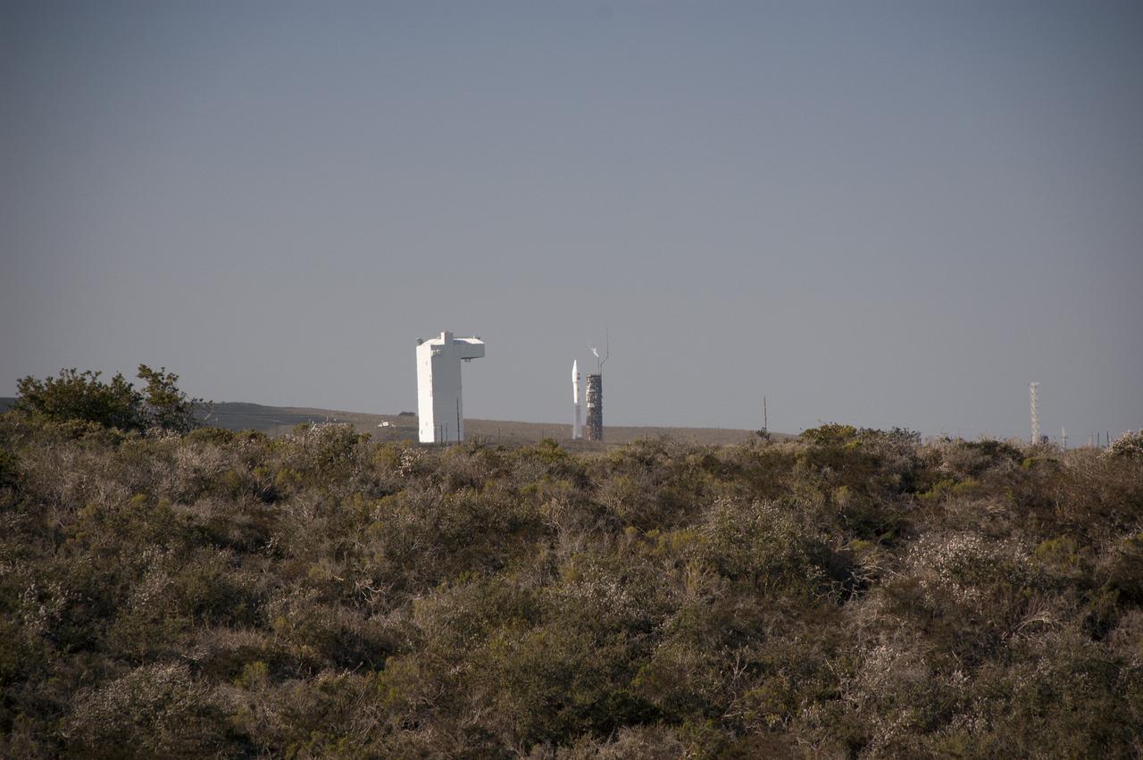
VANDENBERG AFB, Calif. -- The Landsat Data Continuity Mission spacecraft is poised for lift off atop a United Launch Alliance Atlas V rocket from Space Launch Complex 3 at California's Vandenberg Air Force Base. The Landsat Data Continuity Mission LDCM is the future of Landsat satellites. It will continue to obtain valuable data and imagery to be used in agriculture, education, business, science, and government. The Landsat Program provides repetitive acquisition of high resolution multispectral data of the Earth's surface on a global basis. The data from the Landsat spacecraft constitute the longest record of the Earth's continental surfaces as seen from space. It is a record unmatched in quality, detail, coverage, and value. For more information, visit: http:__www.nasa.gov_mission_pages_landsat_main_index.html Photo credit: NASA_Ben Smegelsky
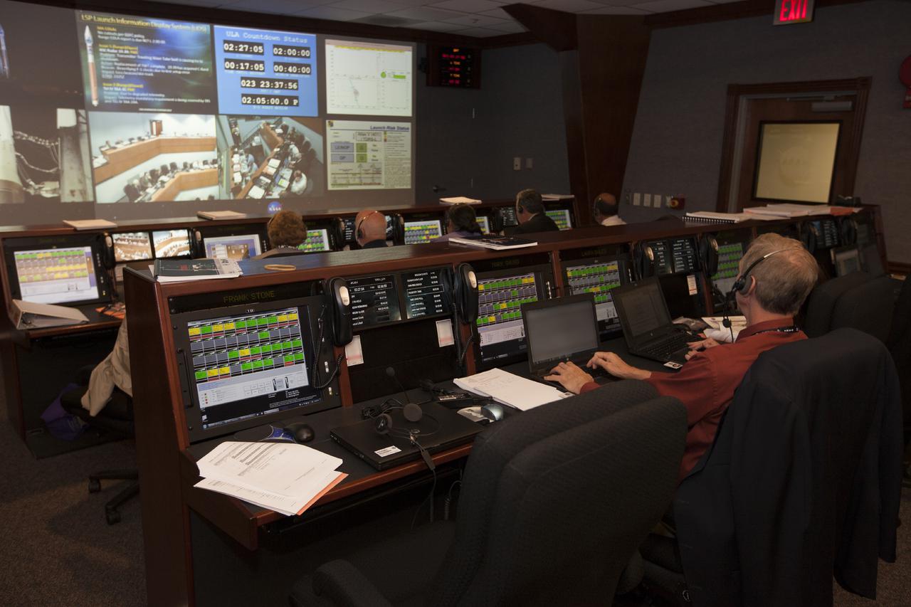
CAPE CANAVERAL, Fla. – In the Hangar AE Mission Director's Center at Cape Canaveral Air Force Station in Florida, NASA and contractor managers and engineers monitor progress of the countdown for the launch the agency's Tracking and Data Relay Satellite, or TDRS-L, spacecraft atop a United Launch Alliance Atlas V rocket. The TDRS-L spacecraft is the second of three new satellites designed to ensure vital operational continuity for NASA by expanding the lifespan of the Tracking and Data Relay Satellite System TDRSS fleet, which consists of eight satellites in geosynchronous orbit. The spacecraft provide tracking, telemetry, command and high bandwidth data return services for numerous science and human exploration missions orbiting Earth. These include NASA's Hubble Space Telescope and the International Space Station. TDRS-L has a high-performance solar panel designed for more spacecraft power to meet the growing S-band communications requirements. TDRSS is one of NASA Space Communication and Navigation’s SCaN three networks providing space communications to NASA’s missions. For more information more about TDRS-L, visit: http:__www.nasa.gov_tdrs To learn more about SCaN, visit: www.nasa.gov_scan Photo credit: NASA_Kim Shiflett
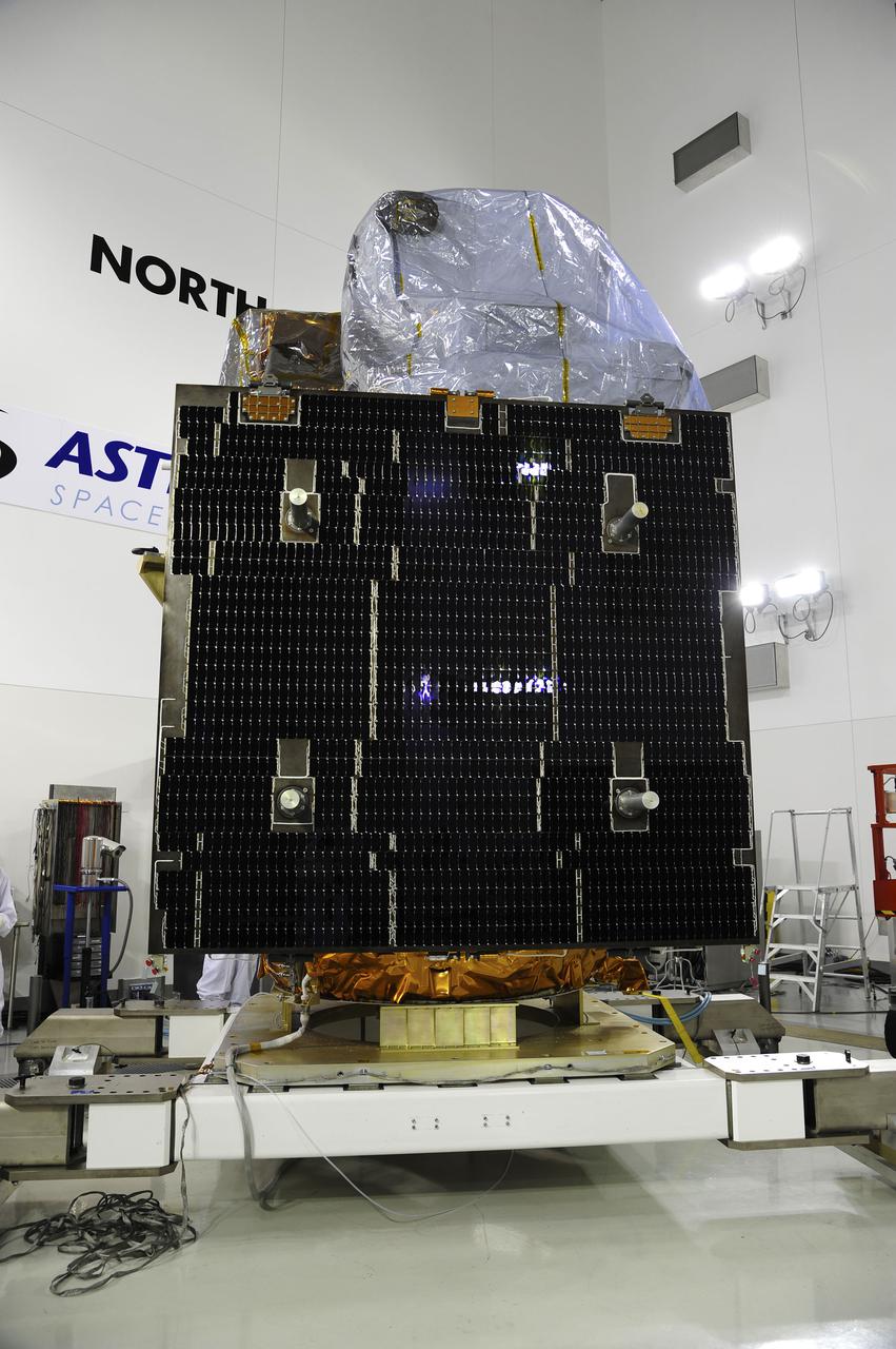
VANDENBERG AFB, Calif. -- At the Astrotech processing facility at Vandenberg Air Force Base, Calif., NASA's Landsat Data Continuity Mission, or LDCM, satellite is undergoing close-outs prior to encapsulation in the payload fairing. The Landsat Data Continuity Mission LDCM is the future of Landsat satellites. It will continue to obtain valuable data and imagery to be used in agriculture, education, business, science, and government. The Landsat Program provides repetitive acquisition of high resolution multispectral data of the Earth's surface on a global basis. The data from the Landsat spacecraft constitute the longest record of the Earth's continental surfaces as seen from space. It is a record unmatched in quality, detail, coverage, and value. Liftoff is planned for Feb. 11, 2013 aboard a United Launch Alliance Atlas V rocket. For more information, visit: http:__www.nasa.gov_mission_pages_landsat_main_index.html Photo credit: NASA

VANDENBERG AIR FORCE BASE, Calif. -- Media attending a post-launch news conference at Vandenberg Air Force Base, Calif. heard from Anne Castle, assistant secretary for Water and Science, U.S. Department of the Interior. The Landsat Data Continuity Mission LDCM is the future of Landsat satellites. It will continue to obtain valuable data and imagery to be used in agriculture, education, business, science, and government. The Landsat Program provides repetitive acquisition of high resolution multispectral data of the Earth's surface on a global basis. The data from the Landsat spacecraft constitute the longest record of the Earth's continental surfaces as seen from space. It is a record unmatched in quality, detail, coverage, and value. Liftoff took place at 10:02 a.m. PST 1:02 P.M. EST) on Feb. 11, 2013 aboard a United Launch Alliance Atlas V rocket. For more information, visit: http:__www.nasa.gov_mission_pages_landsat_main_index.html Photo credit: NASA_Kim Shiflett

VANDENBERG AIR FORCE BASE, Calif. -- Media attending a post-launch news conference at Vandenberg Air Force Base, Calif. heard from officials who described the successful launch of the Landsat Data Continuity Mission, or LDCM. From the left are: George Diller of NASA Public Affairs, Ken Schwer, LDCM project manager Goddard Space Flight Center, Greenbelt, Md., Michael Luther, deputy associate administrator for programs, Science Mission Directorate at NASA Headquarters, Michael Freilich, director of the Earth Science Division, Science Mission Directorate, at Headquarters, Anne Castle, assistant secretary for Water and Science, U.S. Department of the Interior, and Marsha McNutt, director of the U.S. Geological Survey. The Landsat Data Continuity Mission LDCM is the future of Landsat satellites. It will continue to obtain valuable data and imagery to be used in agriculture, education, business, science, and government. The Landsat Program provides repetitive acquisition of high resolution multispectral data of the Earth's surface on a global basis. The data from the Landsat spacecraft constitute the longest record of the Earth's continental surfaces as seen from space. It is a record unmatched in quality, detail, coverage, and value. Liftoff took place at 10:02 a.m. PST 1:02 P.M. EST) on Feb. 11, 2013 aboard a United Launch Alliance Atlas V rocket. For more information, visit: http:__www.nasa.gov_mission_pages_landsat_main_index.html Photo credit: NASA_Kim Shiflett