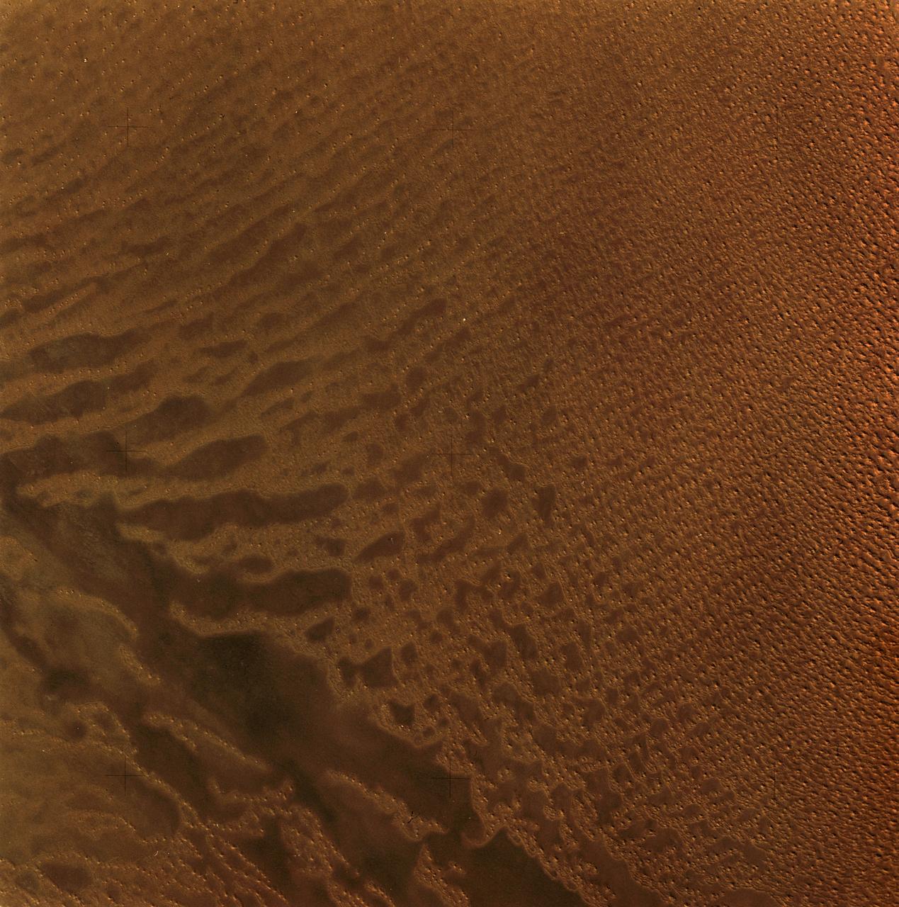
Polar Erg
North Polar Erg
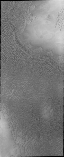
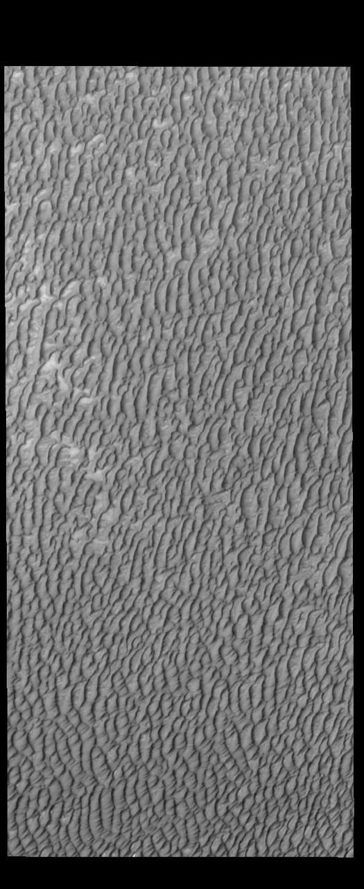
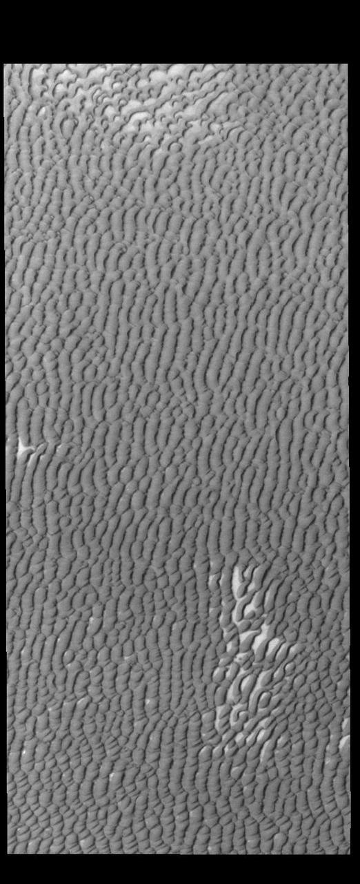
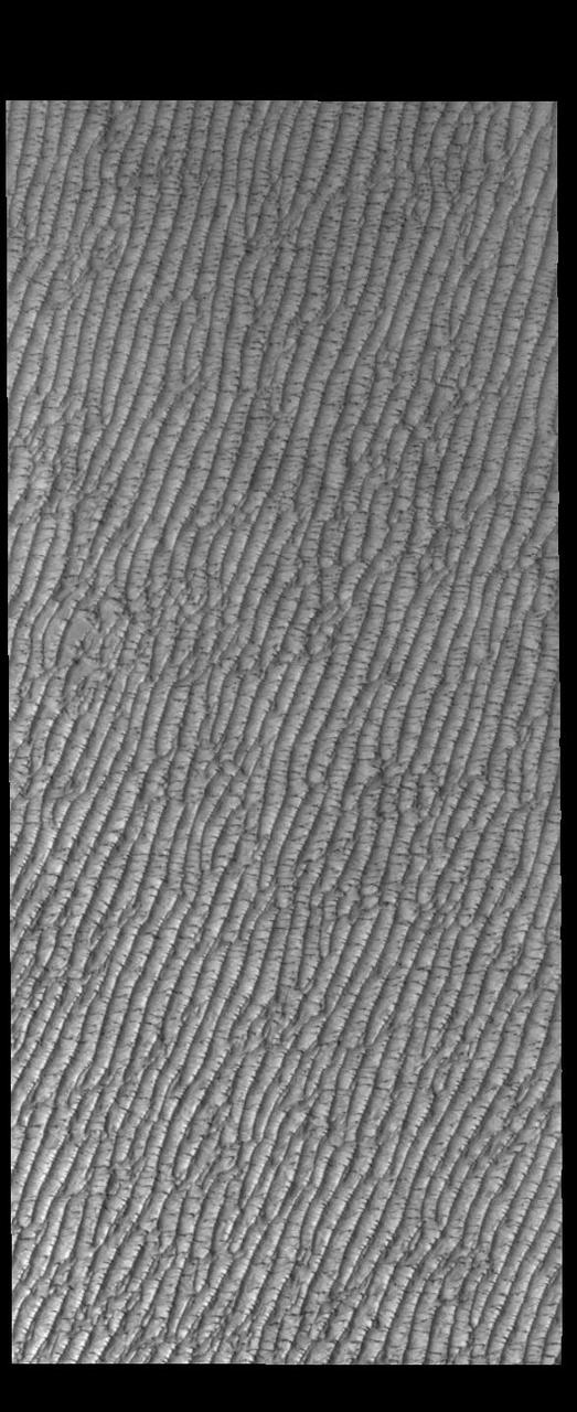
This image shows part of the large dune field or erg that exists surrounding the north polar ice cap
Radially symmetrical, star dunes dominate the Grand Erg Oriental of the Algerian Sahara, as depicted in this image acquired October 27, 2012 acquired by NASA Terra spacecraft.
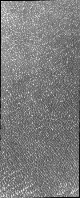
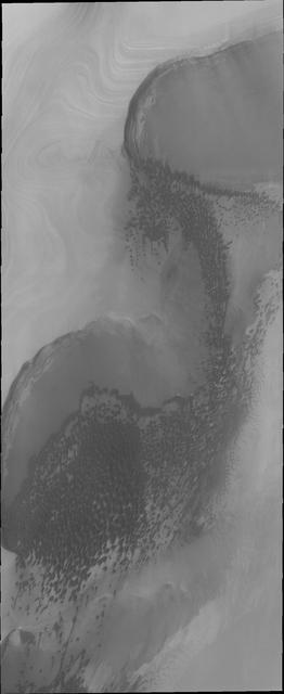
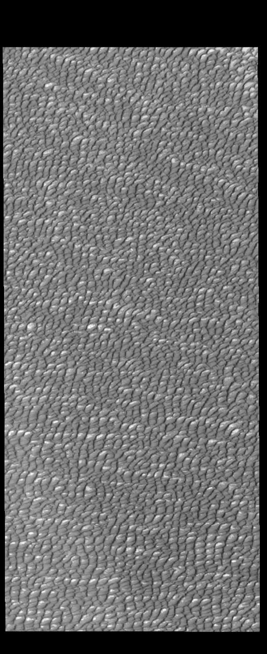
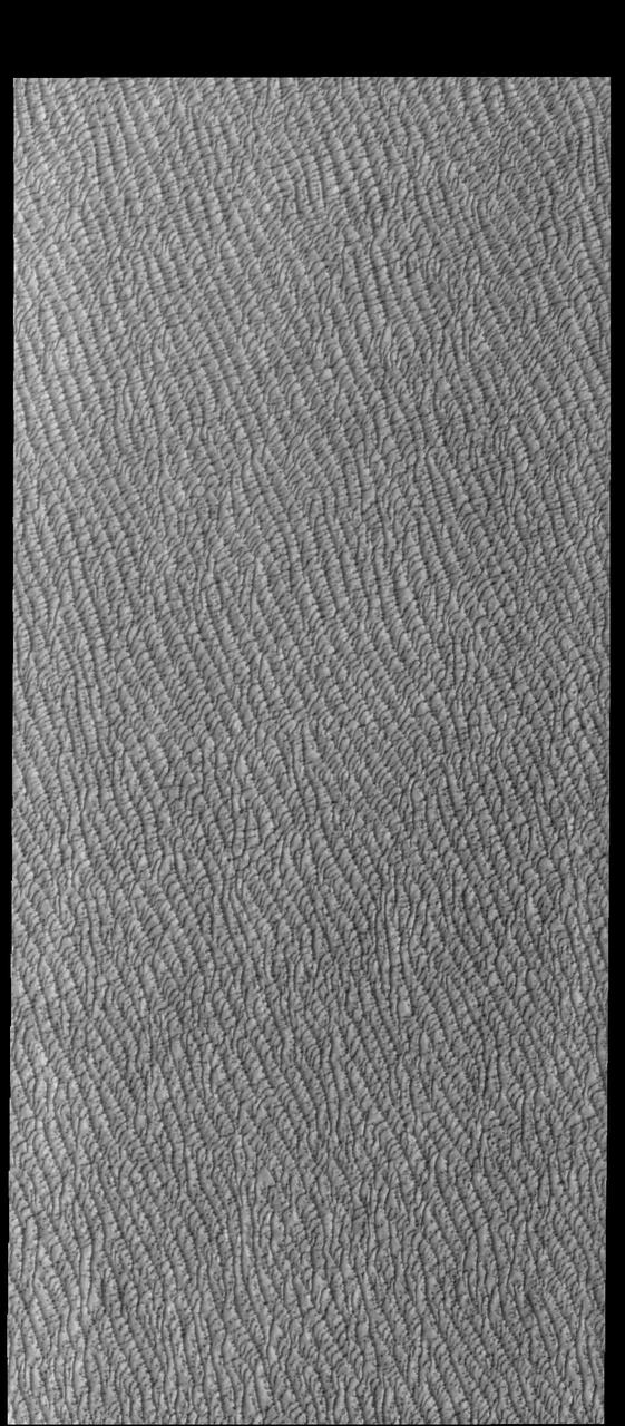
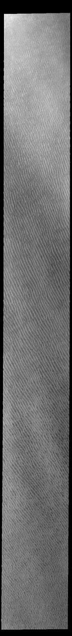
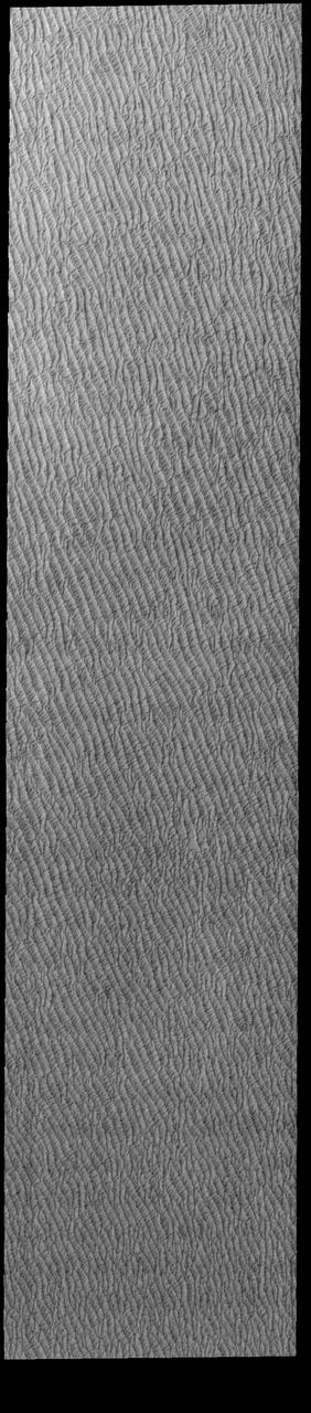
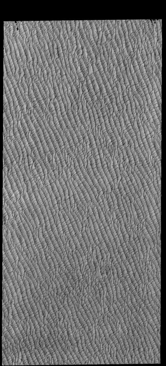
The appearance of the dunes in the North Polar Erg or sand sea changes as the seasons move from winter to summer. This summer image from NASA Mars Odyssey shows the dunes totally free of frost.
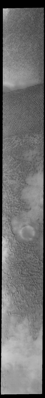
Sand dunes form large fields, called ergs, around the north polar cap of Mars. This image taken by NASA Mars Odyssey shows are region of dunes at the cap margin.
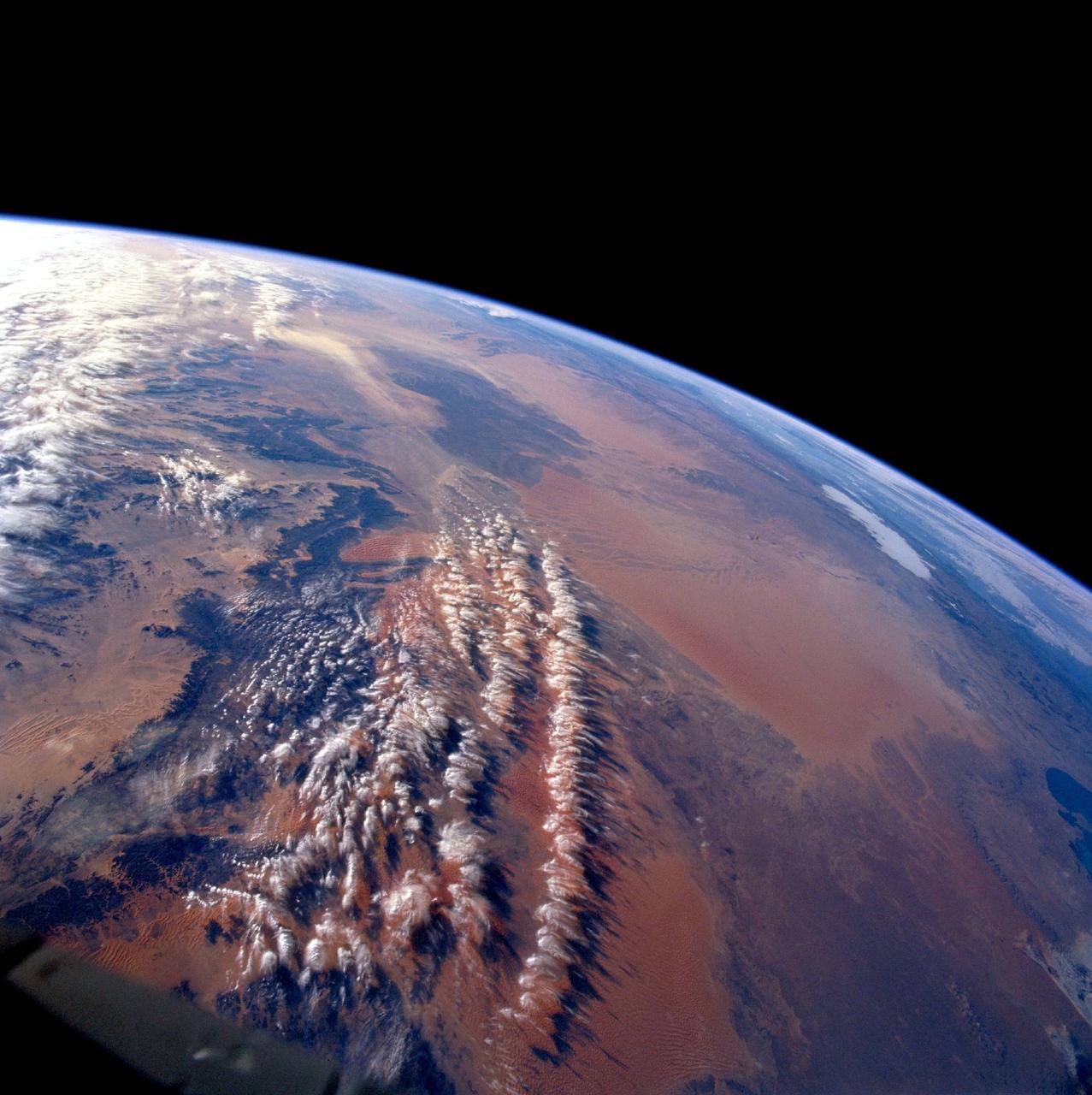
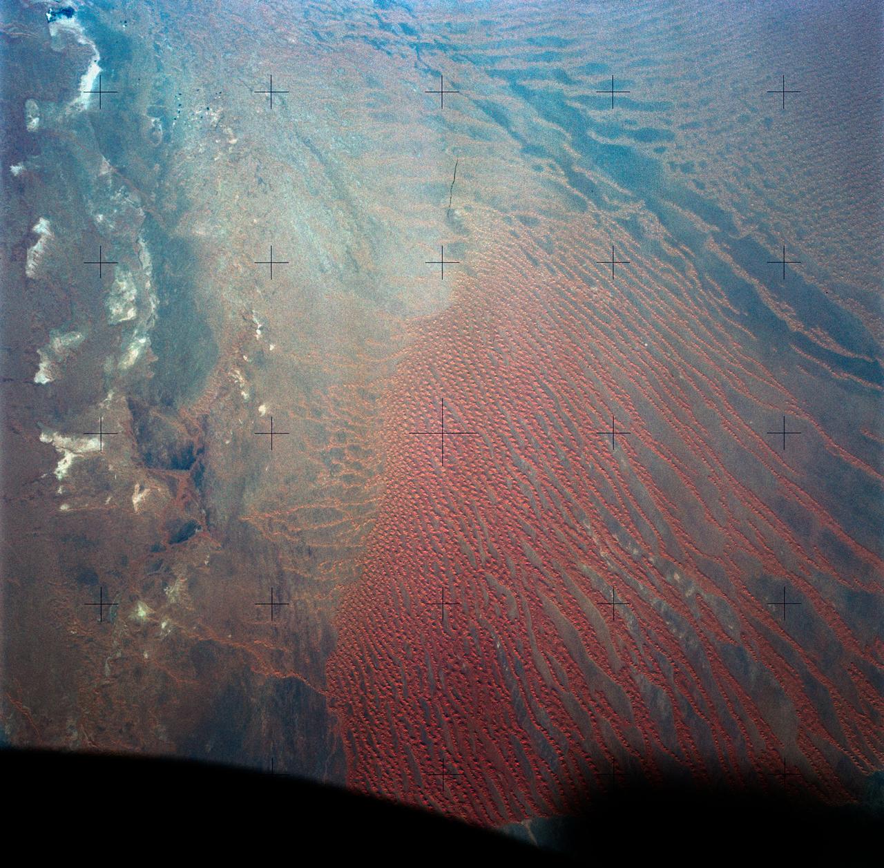
STS103-710-084 (19-27 December 1999)--- One of the astronauts aboard the Earth-orbiting Space Shuttle Discovery used a handheld 70mm camera to photograph the great sand seas which occupy northern Algeria. They are Grand Erg Oriental (Eastern Sand Sea) and Grand Erg Occidental (Western Sand Sea). Both sand seas occupy depressions that are separated by a north-south rise called Mizab. Ergs are areas of large accumulations of sand that take the form of actively shifting dunes, fossilized dunes, or extensive sand sheets.
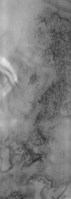
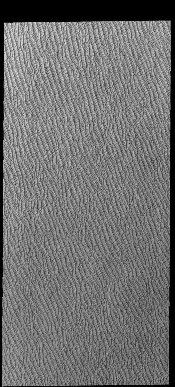
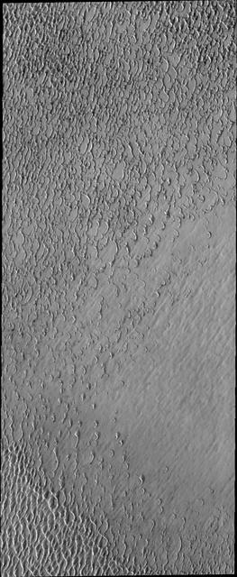
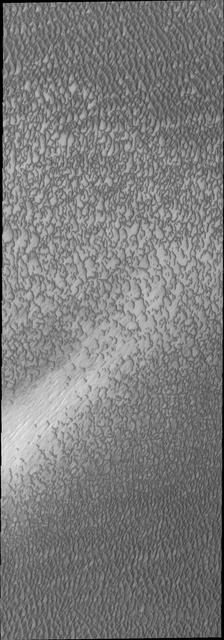
This image from NASA Mars Reconnaissance Orbiter depicts a scene from early spring in the northern hemisphere of Mars. These dunes are covered with a layer of seasonal carbon dioxide ice dry ice.
41C-31-990 (6-13 April 1984) --- Southwestern Algeria's Erg Chech shows long lines of parallel sand dunes called siefs. The Erg (sand desert) is in a remote (26.5 degrees north by 1.5 degrees west) of harsh desert, uninhabited and rarely visited. These parallel sand dunes are about 100 miles in length and 5 to 10 miles apart and are found in very few areas of the Earth. Most sand dunes are traverse dunes, or perpendicular to the general direction of the wind.
For the first time scientists have calculated the age of star dunes (or pyramid dunes). Some of the tallest – over 100 m high – are located in the Erg Chebbi sand sea in southeast Morocco. Using luminescence dating techniques, the dunes were found to have formed over 13,000 years ago. The perspective view has 5X vertical exaggeration. The image was acquired October 2, 2020, covers an area of 13.5 by 20.4 km, and is located at 31.2 degrees north, 4 degrees west. https://photojournal.jpl.nasa.gov/catalog/PIA26287

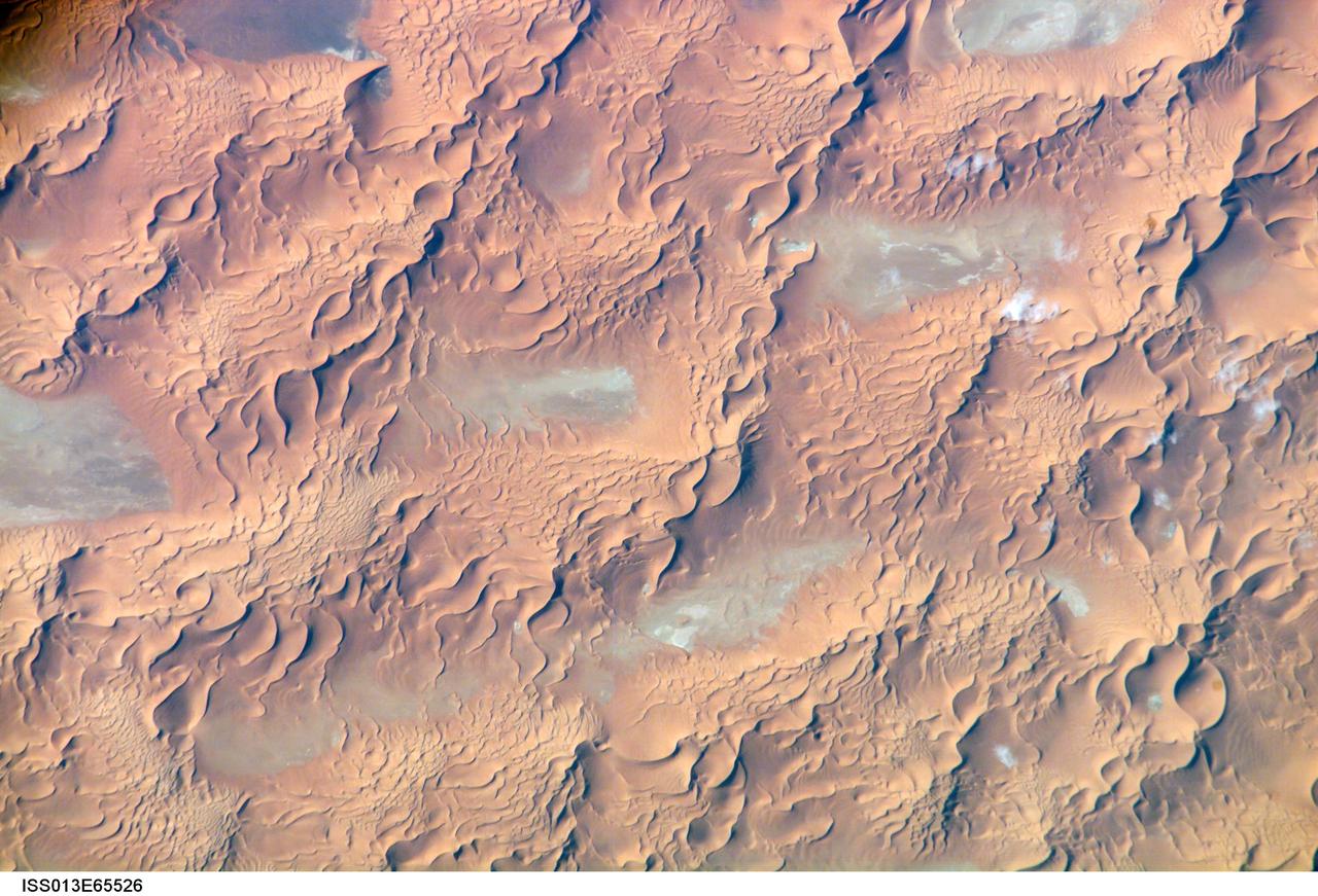
ISS013-E-75141 (2 Sept. 2006) --- Erg Oriental, Algeria is featured in this image photographed by an Expedition 13 crewmember onboard the International Space Station. One of the main interests of rainless regions like the Sahara Desert to landscape science is that the work of flowing water--mainly streams and rivers--becomes less important than the work of wind. According to scientists, over millennia, and if enough sand is available, winds can generate dunes of enormous size, arranged in regular patterns. Long, generally north-south trending linear dunes stretch across much of northeast Algeria covering a vast tract (approximately 140,000 kilometers square) of the Sahara Desert known as the Erg Oriental. Erg means dune sea in Arabic, and the term has been adopted into modern geology. Spanning this image diagonally are a series of two kilometer-wide linear dunes, comprised of red sand, from a point on the southwest margin of the erg (center point 28.9N 4.8W). The dune chains are more than 100 meters high. The "streets" between the dunes are grayer areas free of sand. Linear dune chains are usually generated roughly parallel with the dominant winds. It also seems to be true that linear dunes are built by stronger winds. This detailed view shows that smaller dunes, known as star dunes, are built on top of the linear dunes. By contrast, star dunes seem to form in weak wind regimes, with winds from different directions in each season -- resulting in characteristic "arms" snaking away from a central point. Some scientists therefore think the dunes in this image were generated in two earlier climatic phases, different from that of today. (1) During a phase when winds were stronger and dominantly from one direction (the south), major linear sand masses accumulated. (2) Later, when wind strengths declined, the star dunes formed. Modern features--known as wind streaks--on the edge of the present erg (not shown), younger than either the linear or star dunes, show that present-day sand-moving winds blow from the southwest.
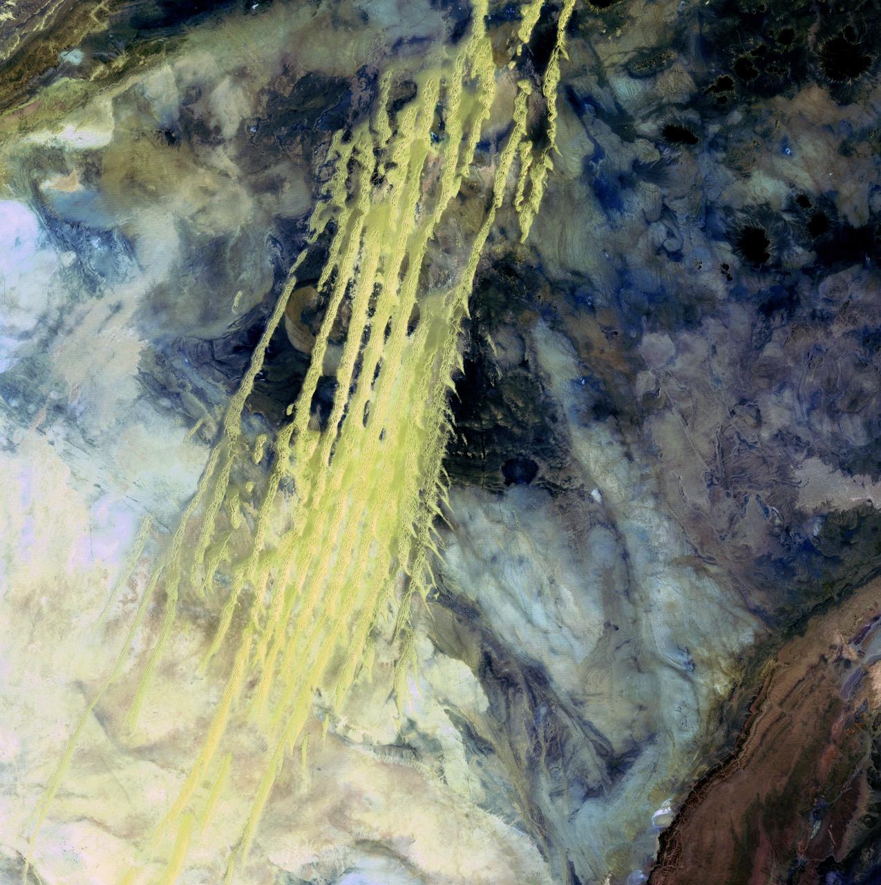
Algerian Abstract - April 8th, 1985 Description: What look like pale yellow paint streaks slashing through a mosaic of mottled colors are ridges of wind-blown sand that make up Erg Iguidi, an area of ever-shifting sand dunes extending from Algeria into Mauritania in northwestern Africa. Erg Iguidi is one of several Saharan ergs, or sand seas, where individual dunes often surpass 500 meters-nearly a third of a mile-in both width and height. Credit: USGS/NASA/Landsat 5 To learn more about the Landsat satellite go to: <a href="http://landsat.gsfc.nasa.gov/" rel="nofollow">landsat.gsfc.nasa.gov/</a> <b><a href="http://www.nasa.gov/centers/goddard/home/index.html" rel="nofollow">NASA Goddard Space Flight Center</a></b> enables NASA’s mission through four scientific endeavors: Earth Science, Heliophysics, Solar System Exploration, and Astrophysics. Goddard plays a leading role in NASA’s accomplishments by contributing compelling scientific knowledge to advance the Agency’s mission. <b>Follow us on <a href="http://twitter.com/NASA_GoddardPix" rel="nofollow">Twitter</a></b> <b>Join us on <a href="http://www.facebook.com/pages/Greenbelt-MD/NASA-Goddard/395013845897?ref=tsd" rel="nofollow">Facebook</a></b>
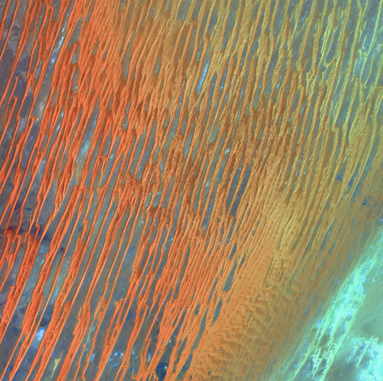
Desert Patterns - April 13th, 2003 Description: Seen through the "eyes" of a satellite sensor, ribbons of Saharan sand dunes seem to glow in sunset colors. These patterned stripes are part of Erg Chech, a desolate sand sea in southwestern Algeria, Africa, where the prevailing winds create an endlessly shifting collage of large, linear sand dunes. The term "erg" is derived from an Arabic word for a field of sand dunes. Credit: USGS/NASA/Landsat 7 To learn more about the Landsat satellite go to: <a href="http://landsat.gsfc.nasa.gov/" rel="nofollow">landsat.gsfc.nasa.gov/</a> <b><a href="http://www.nasa.gov/centers/goddard/home/index.html" rel="nofollow">NASA Goddard Space Flight Center</a></b> enables NASA’s mission through four scientific endeavors: Earth Science, Heliophysics, Solar System Exploration, and Astrophysics. Goddard plays a leading role in NASA’s accomplishments by contributing compelling scientific knowledge to advance the Agency’s mission. <b>Follow us on <a href="http://twitter.com/NASA_GoddardPix" rel="nofollow">Twitter</a></b> <b>Join us on <a href="http://www.facebook.com/pages/Greenbelt-MD/NASA-Goddard/395013845897?ref=tsd" rel="nofollow">Facebook</a></b>
SL3-34-056 (July-September 1973) --- A near vertical view of an 8,000 square-mile area of the Grand Erg Oriental in east central Algeria as photographed from Earth orbit by one of the six lenses of the Itek-furnished S190-A Multispectral Photographic Facility Experiment in the Multiple Docking Adapter of the Skylab space station. The Grand Erg contains vast areas of sand dunes and sand plains. This photograph illustrates the variety of surface features that are characteristic of the Sahara Desert. The dark areas are relatively sand free, and may contain rock outcrops along which travel is considerably easier. Sand dunes are abundant in this picture, and their size, shape, location and pattern are due to the underlying topography and direction of the prevailing winds. Scientists interested in study of dune fields will be able to use this photograph for detailed analysis of the dune features, especially their characteristics adjacent to the sand-free areas. Federal agencies participating with NASA on the EREP project are the Departments of Agriculture, Commerce, Interior, the Environmental Protection Agency and the Corps of Engineers. All EREP photography is available to the public through the Department of Interior?s Earth Resources Observations Systems Data Center, Sioux Falls, South Dakota, 57198. Photo credit: NASA
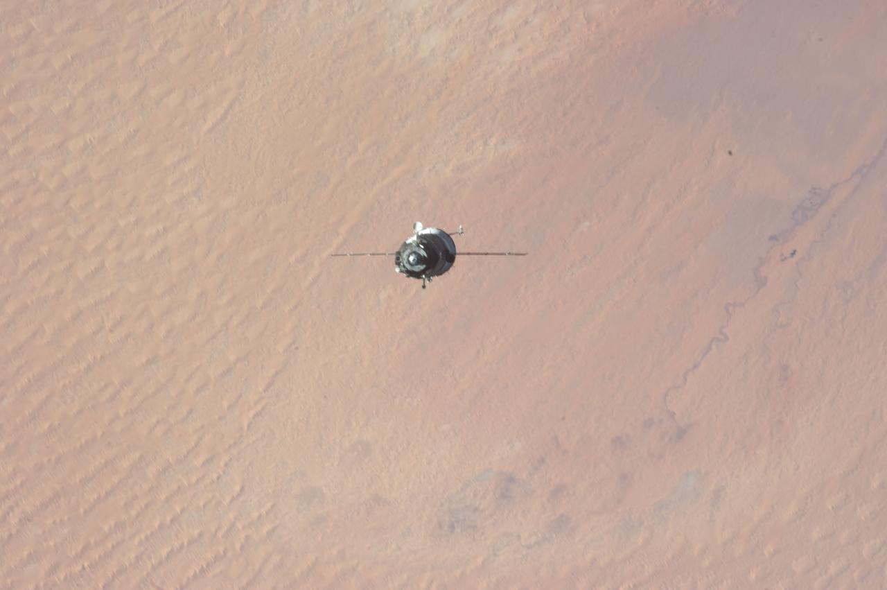
ISS034-E-009926 (21 Dec. 2012) --- As the International Space Station and Soyuz TMA-07M spacecraft were making their relative approaches on Dec. 21, one of the Expedition 34 crew members on the orbital outpost captured this photo of the Soyuz over the Sahara Desert. The image center is at 31.7 degrees north latitude and 2.0 degrees east longitude, on the south side of the Atlas Mountains and on the northern margin of a huge dune field known as Grand Erg Occidental, located in north central Algeria. Inside the arriving spacecraft were astronaut Chris Hadfield of the Canadian Space Agency, cosmonaut Roman Romanenko of Russia's Federal Space Agency and NASA astronaut Tom Marshburn.
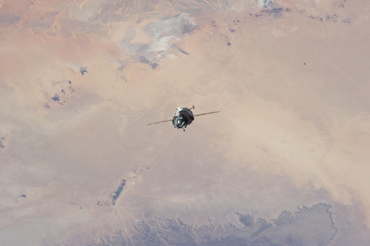
ISS034-E-009924 (21 Dec. 2012) --- As the International Space Station and Soyuz TMA-07M spacecraft were making their relative approaches on Dec. 21, one of the Expedition 34 crew members on the orbital outpost captured this photo of the Soyuz backdropped by the Sahara Desert. Inside the arriving spacecraft were astronaut Chris Hadfield of the Canadian Space Agency, cosmonaut Roman Romanenko of Russia's Federal Space Agency and NASA astronaut Tom Marshburn. The image center is at 31.7 degrees north latitude and 2.0 degrees east longitude, on the south side of the Atlas Mountains and on the northern margin of a huge dune field known as Grand Erg Occidental, located in north central Algeria.
S65-63830 (5 Dec. 1965) --- Algeria, south-southeast of the Colomb Bechar area, as seen from the National Aeronautics and Space Administration's Gemini-7 spacecraft. Sand dunes are 200 to 300 feet high in the Grand Erg Occidental area. The Quod Sacura River can be seen in the upper left corner. The white spot in the middle of the picture is the Sebcha el Malah salt beds. It should be noted that the area had just experienced very heavy rains (first in many years) and the stream and salt flat are inundated. This photograph was taken with a modified 70mm Hasselblad camera, with Eastman Kodak, Ektachrome MS (S.O. 217) color film. Photo credit: NASA
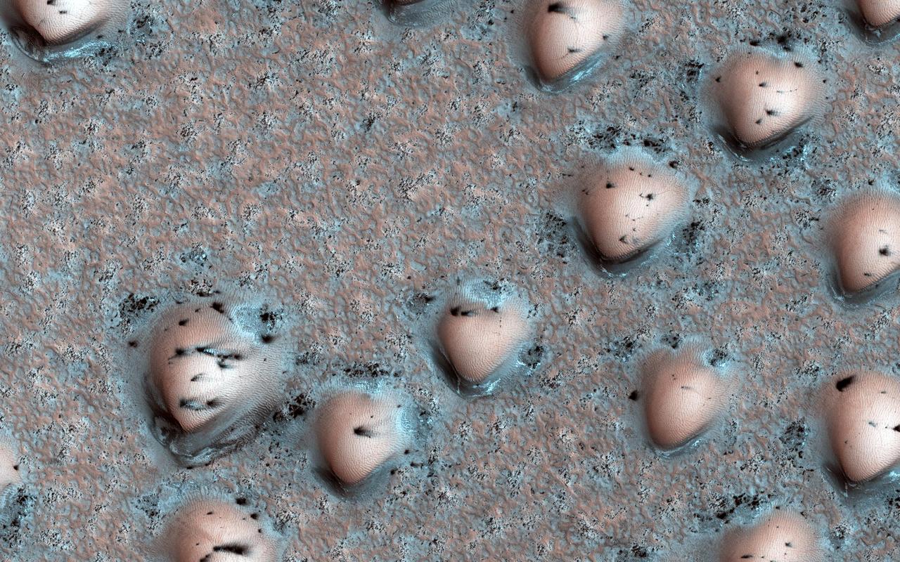
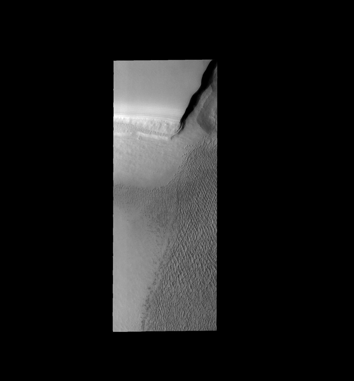
It's spring in the Northern Hemisphere of Mars, and the polar region is still blanketed by seasonal carbon dioxide frost (dry ice). This image shows an area near the sand sea (called an "erg") that is surrounding the water ice-rich layered deposits. The many bumps are sand dunes less than 100 meters across that are mostly covered by seasonal frost, appearing in a manner that looks artificial but is a natural consequence of the wind patterns in this region. The smaller, darker spots are places where the seasonal frost has sublimed away, exposing the dark surface below. The combination of these features makes for an unearthly scene! https://photojournal.jpl.nasa.gov/catalog/PIA23527

Jakebia Keith, program and contract analyst for the IT Resources Management Office and secretary for the Black Employee Strategy Team (BEST), one of the center’s employee resource groups, stands during recognition at the Black History Month celebration on Feb. 18, 2020, at NASA’s Kennedy Space Center in Florida. The program was organized by BEST. This year’s theme was “African Americans and the Vote.” James Jennings, former NASA associate administrator for Institutions and Management and former Kennedy Space Center deputy director, was keynote speaker at the event.

James Jennings, former NASA associate administrator for Institutions and Management and former Kennedy Space Center deputy director, was the keynote speaker at the center’s Black History Month celebration on Feb. 18, 2020. The program was organized by the Black Employee Strategy Team (BEST), one of the center’s employee resource groups. This year’s theme was “African Americans and the Vote.” Jennings shared advice with workers and managers.

Martin Hayes, program analyst with Exploration Ground Systems and chairperson of the Black Employee Strategy Team (BEST), one of the center’s employee resource groups, speaks to attendees during a Black History Month celebration on Feb. 18, 2020, at NASA’s Kennedy Space Center in Florida. The program was organized by BEST. This year’s theme was “African Americans and the Vote.” James Jennings, former NASA associate administrator for Institutions and Management and former Kennedy Space Center deputy director, was keynote speaker at the event.

During a Black History Month celebration on Feb. 18, 2020 at NASA’s Kennedy Space Center in Florida, Hortense Diggs, director of Communication and Public Engagement, commemorates the contributions of former NASA employee and mentor Roslyn McKinney. The program was organized by the Black Employee Strategy Team (BEST), one of the center’s employee resource groups. This year’s theme was “African Americans and the Vote.” Keynote speaker was James Jennings, former NASA associate administrator for Institutions and Management and Kennedy’s former deputy director. Jennings shared advice with workers and managers.

NASA and contractor workers attend a Black History Month celebration at Kennedy Space Center in Florida on Feb. 18, 2020. James Jennings, former NASA associate administrator for Institutions and Management and former Kennedy Space Center deputy director, was the keynote speaker. The program was organized by the Black Employee Strategy Team (BEST), one of the center’s employee resource groups. This year’s theme was “African Americans and the Vote.” Jennings shared advice with workers and managers.

A Black History Month celebration was held on Feb. 18, 2020 at NASA’s Kennedy Space Center in Florida. The program was organized by the Black Employee Strategy Team (BEST), one of the center’s employee resource groups. This year’s theme was “African Americans and the Vote.” From left are Kim Carter, associate program manager, Exploration Ground Systems; James Jennings, keynote speaker, former NASA associate administrator for Institutions and Management and Kennedy’s former deputy director; and Hortense Diggs, director of Communication and Public Engagement.

A Black History Month celebration was held on Feb. 18, 2020 at NASA’s Kennedy Space Center in Florida. The program was organized by the Black Employee Strategy Team (BEST), one of the center’s employee resource groups. This year’s theme was “African Americans and the Vote.” From left are Kelvin Manning, Kennedy’s associate director, technical; Daren Etienne, BEST marketing director; James Jennings, keynote speaker, former NASA associate administrator for Institutions and Management and Kennedy’s former deputy director; Martin Hayes, BEST chairperson; Jakebia Keith, program and contract analyst for the IT Resources Management Office and BEST secretary; and Phillip Hargrove, BEST co-chairperson.

During a Black History Month celebration on Feb. 18, 2020 at NASA’s Kennedy Space Center in Florida, Hortense Diggs, at the podium, director of Communication and Public Engagement, commemorates the contributions of former NASA employee and mentor Roslyn McKinney. The program was organized by the Black Employee Strategy Team (BEST), one of the center’s employee resource groups. This year’s theme was “African Americans and the Vote.” Keynote speaker was James Jennings, seated, far right, former NASA associate administrator for Institutions and Management and Kennedy’s former deputy director. Jennings shared advice with workers and managers.

Burt Summerfield, associate director, management, attends the Black History Month celebration at Kennedy Space Center in Florida on Feb. 18, 2020. The program was organized by the Black Employee Strategy Team (BEST), one of the center’s employee resource groups. This year’s theme was “African Americans and the Vote.” Keynote speaker was James Jennings, former NASA associate administrator for Institutions and Management and Kennedy’s former deputy director. Jennings shared advice with workers and managers.

Kelvin Manning, associate director, technical, attends the Black History Month celebration at Kennedy Space Center in Florida on Feb. 18, 2020. The program was organized by the Black Employee Strategy Team (BEST), one of the center’s employee resource groups. This year’s theme was “African Americans and the Vote.” Keynote speaker was James Jennings, former NASA associate administrator for Institutions and Management and Kennedy’s former deputy director. Jennings shared advice with workers and managers.

Jakebia Keith, program and contract analyst for the IT Resources Management Office, welcomes NASA and contractor workers to the Black History Month celebration at NASA’s Kennedy Space Center in Florida on Feb. 18, 2020. The program was organized by the Black Employee Strategy Team (BEST), one of the center’s employee resource groups. This year’s theme was “African Americans and the Vote.” Keynote speaker was James Jennings, former NASA associate administrator for Institutions and Management and Kennedy’s former deputy director. Jennings shared advice with workers and managers.

James Jennings, at left, former NASA associate administrator for Institutions and Management and former Kennedy Space Center deputy director, was the keynote speaker at the center’s Black History Month celebration on Feb. 18, 2020. He received a Certificate of Appreciation from the program’s organizer, the Black Employee Strategy Team (BEST), one of the center’s employee resource groups. At right is Martin Hayes, program analyst with Exploration Ground Systems and BEST chairperson. This year’s theme was “African Americans and the Vote.” Jennings shared advice with workers and managers.

Chuck Dovale, deputy director of NASA’s Launch Services Program, attends the Black History Month celebration at Kennedy Space Center in Florida on Feb. 18, 2020. The program was organized by the Black Employee Strategy Team (BEST), one of the center’s employee resource groups. This year’s theme was “African Americans and the Vote.” Keynote speaker was James Jennings, former NASA associate administrator for Institutions and Management and Kennedy’s former deputy director. Jennings shared advice with workers and managers.

Kennedy Space Center Director Bob Cabana, at right, speaks with James Jennings, former NASA associate administrator for Institutions and Management and former Kennedy deputy director, during the center’s Black History Month celebration on Feb. 18, 2020. Jennings was the keynote speaker. The program was organized by the Black Employee Strategy Team (BEST), one of the center’s employee resource groups. This year’s theme was “African Americans and the Vote.” Jennings shared advice with workers and managers.

Hortense Diggs, director of Communication and Public Engagement, stands during the singing of the National Anthem at the Black History Month celebration at NASA’s Kennedy Space Center in Florida on Feb. 18, 2020. The program was organized by the Black Employee Strategy Team (BEST), one of the center’s employee resource groups. This year’s theme was “African Americans and the Vote.” Keynote speaker was James Jennings, former NASA associate administrator for Institutions and Management and Kennedy’s former deputy director. Jennings shared advice with workers and managers.

Kelvin Manning, Kennedy Space Center’s associate director, technical, addresses the audience during a Black History Month celebration at the center on Feb. 18, 2020. The program was organized by the Black Employee Strategy Team (BEST), one of the center’s employee resource groups. This year’s theme was “African Americans and the Vote.” Keynote speaker was James Jennings, former NASA associate administrator for Institutions and Management and Kennedy’s former deputy director. Jennings shared advice with workers and managers.

Kennedy Space Center Director Bob Cabana, at right, greets James Jennings, former NASA associate administrator for Institutions and Management and former Kennedy deputy director, during the center’s Black History Month celebration on Feb. 18, 2020. Jennings was the event’s keynote speaker. The program was organized by the Black Employee Strategy Team (BEST), one of the center’s employee resource groups. This year’s theme was “African Americans and the Vote.” Jennings shared advice with workers and managers.

Yvonne Williams, in front, administrative assistant with Jacobs, sings the National Anthem at the start of the Black History Month celebration at NASA’s Kennedy Space Center in Florida on Feb. 18, 2020. The program was organized by the Black Employee Strategy Team (BEST), one of the center’s employee resource groups. This year’s theme was “African Americans and the Vote.” Keynote speaker was James Jennings, former NASA associate administrator for Institutions and Management and Kennedy’s former deputy director. Jennings shared advice with workers and managers.

James Jennings, former NASA associate administrator for Institutions and Management and former Kennedy Space Center deputy director, was the keynote speaker at the center’s Black History Month celebration on Feb. 18, 2020. The program was organized by the Black Employee Strategy Team (BEST), one of the center’s employee resource groups. This year’s theme was “African Americans and the Vote.” Jennings shared advice with workers and managers.

Henrietta Hanner, an administrative assistant in Safety and Mission Assurance, speaks about the theme of this year’s Black History Month celebration at NASA’s Kennedy Space Center in Florida on Feb. 18, 2020. The program was organized by the Black Employee Strategy Team (BEST), one of the center’s employee resource groups. This year’s theme was “African Americans and the Vote.” Keynote speaker was James Jennings, former NASA associate administrator for Institutions and Management and Kennedy’s former deputy director. Jennings shared advice with workers and managers.

NASA and contractor workers attend a Black History Month celebration at Kennedy Space Center in Florida on Feb. 18, 2020. James Jennings, former NASA associate administrator for Institutions and Management and former Kennedy Space Center deputy director, was the keynote speaker. The program was organized by the Black Employee Strategy Team (BEST), one of the center’s employee resource groups. This year’s theme was “African Americans and the Vote.” Jennings shared advice with workers and managers.

Michael Bell, chief, Knowledge Office, introduces keynote speaker James Jennings during the Black History Month celebration at NASA’s Kennedy Space Center in Florida on Feb. 18, 2020. Jennings is the former associate administrator for NASA Institutions and Management and former deputy director of Kennedy. The program was organized by the Black Employee Strategy Team (BEST), one of the center’s employee resource groups. This year’s theme was “African Americans and the Vote.” Jennings shared advice with workers and managers.
SL4-138-3820 (31 Dec. 1973) --- An north-looking oblique view of chains of star sand dunes in eastern Algeria as seen from the Skylab space station in Earth orbit. This picture was taken by one of the Skylab 4 crewmen with a hand-held 70mm Hasselblad camera. The low sun angle of about 25 degrees above horizontal enhances the detail in this picture. The coordinates of the center of the photograph are approximately 29.5 degrees north latitude and 5.0 degrees east longitude in the Grand Erg Oriental. The field of view at the base of the photograph is approximately 200 kilometers (125 miles). The individual dunes are roughly star-shaped rather than simple crescents which are common in dune fields. In this region the stars are aligned along ridges. The causes of these and a wide variety of other dune forms are little understood. Descriptions and photographs from Skylab 4 will be used by the U.S. Geological Survey in their world-wide study of dunes. Photo credit: NASA
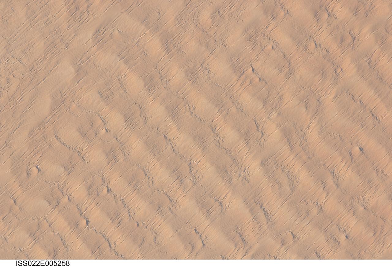
ISS022-E-005258 (1 Dec. 2009) --- This detailed hand-held digital camera?s image recorded from the International Space Station highlights sand dunes in the Fachi-Bilma erg, or sand sea, which is part of the central eastern Tenere Desert. The Tenere occupies much of southeastern Niger and is considered to be part of the larger Sahara Desert that stretches across northern Africa. Much of the Sahara is comprised of ergs ? with an area of approximately 150,000 square kilometers, the Fachi-Bilma is one of the larger sand seas. Two major types of dunes are visible in the image. Large, roughly north-south oriented transverse dunes fill the image frame. This type of dune tends to form at roughly right angles to the dominant northeasterly winds. The dune crests are marked in this image by darker, steeper sand accumulations that cast shadows. The lighter-toned zones between are lower interdune ?flats?. The large dunes appear to be highly symmetrical with regard to their crests. This suggests that the crest sediments are coarser, preventing the formation of a steeper slip face on the downwind side of the dune by wind-driven motion of similarly-sized sand grains. According to NASA scientists, this particular form of transverse dune is known as a zibar, and is thought to form by winnowing of smaller sand grains by the wind, leaving the coarser grains to form dune crests. A second set of thin linear dunes oriented at roughly right angles to the zibar dunes appears to be formed on the larger landforms and is therefore a younger landscape feature. These dunes appear to be forming from finer grains in the same wind field as the larger zibars. The image was taken with digital still camera fitted with a 400 mm lens, and is provided by the ISS Crew Earth Observations experiment and Image Science & Analysis Laboratory, Johnson Space Center.
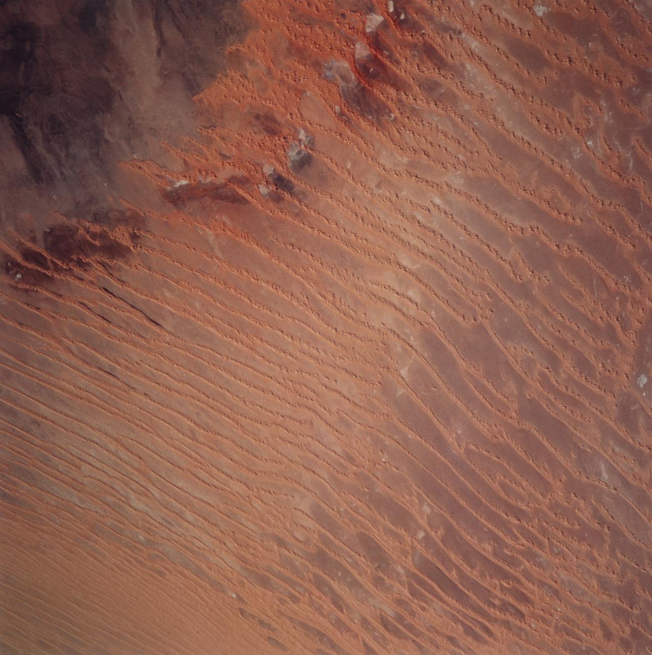
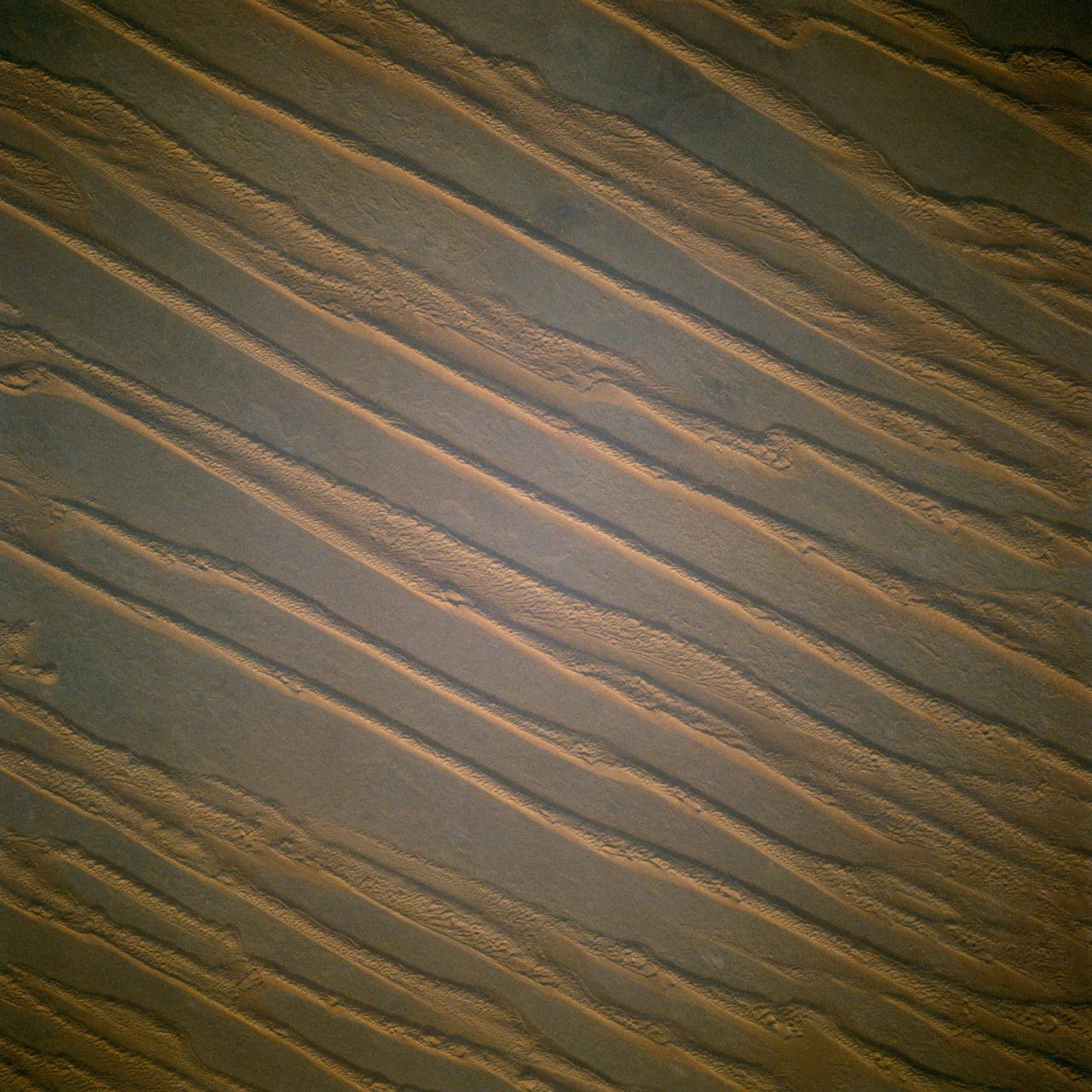
STS099-729-045 (11-22 February 2000) ---This Earth scene from the Space Shuttle Endeavour features linear dunes in the Algerian Saharan sand sea known as the Erg Chech. The dunes, according to NASA scientists, have been built up over thousands of years into masses elongated roughly parallel with the prevailing northeast winds. Dune chains in the northern (upper) half of the view are 5-8 kilometers apart. A slight change in orientation and an increase in the density of dunes appear across the middle of the view. Such changes usually relate to changes in sand supply, and also to topographic scarps over which the dunes pass. Obstacles like scarps and hills locally cause a leftward deflection (in the Northern Hemisphere) in wind direction, an effect that can be seen here in the dune orientation in the middle of the photo. Dunes in the lower part of the view are 2-5 kilometers apart. White patches are small dry lakes at low points in the underlying rock surface. The strong red color in some dunes near the edge of the dune field (left margin) is iron staining derived from sand particles blown into the dunes from the underlying iron-rich soils. A dune-free area appears in the lower left corner.
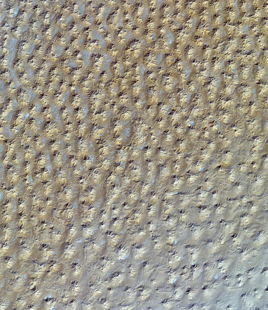
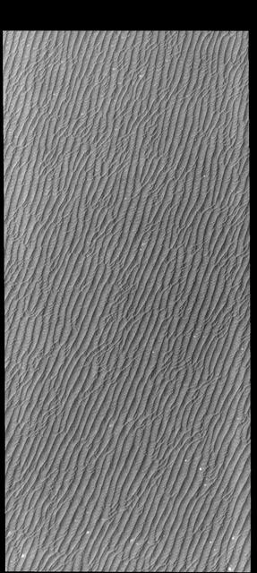
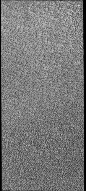
This VIS image of Olympia Undae was collected during north polar summer. The dune crests have completely lost the winter frosts, revealing the dark sand. The density of dunes and the alignments of the dune crests varies with location, controlled by the amount of available sand and the predominant winds over time. Olympia Undae is a vast dune field in the north polar region of Mars. It consists of a broad sand sea or erg that partly rings the north polar cap from about 120° to 240°E longitude and 78° to 83°N latitude. The dune field covers an area of approximately 470,000 km2 (bigger than California, smaller than Texas). Olympia Undae is the largest continuous dune field on Mars. Olympia Undae is not the only dune field near the north polar cap, several other smaller fields exist in the same latitude, but in other ranges of longitude, e.g. Abolos and Siton Undae. Barchan and transverse dune forms are the most common. In regions with limited available sand individual barchan dunes will form, the surface beneath and between the dunes is visible. In regions with large sand supplies, the sand sheet covers the underlying surface, and dune forms are found modifying the surface of the sand sheet. In this case transverse dunes are more common. Barchan dunes "point" down wind, transverse dunes are more linear and form parallel to the wind direction. The "square" shaped transverse dunes in Olympia Undae are due to two prevailing wind directions. Orbit Number: 87767 Latitude: 81.8559 Longitude: 167.732 Instrument: VIS Captured: 2021-09-27 01:24 https://photojournal.jpl.nasa.gov/catalog/PIA25269

This VIS image of Olympia Undae was collected at the very end of north polar spring. As the season changes into summertime, the dune crests have lost all the winter frosts completely revealing the darker sand beneath. The density of dunes and the alignments of the dune crests varies with location, controlled by the amount of available sand and the predominant winds over time. Olympia Undae is a vast dune field in the north polar region of Mars. It consists of a broad sand sea or erg that partly rings the north polar cap from about 120° to 240°E longitude and 78° to 83°N latitude. The dune field covers an area of approximately 470,000 km2 (bigger than California, smaller than Texas). Olympia Undae is the largest continuous dune field on Mars. Olympia Undae is not the only dune field near the north polar cap, several other smaller fields exist in the same latitude, but in other ranges of longitude, e.g. Abolos and Siton Undae. Barchan and transverse dune forms are the most common. In regions with limited available sand individual barchan dunes will form, the surface beneath and between the dunes is visible. In regions with large sand supplies, the sand sheet covers the underlying surface, and dune forms are found modifying the surface of the sand sheet. In this case transverse dunes are more common. Barchan dunes "point" down wind, transverse dunes are more linear and form parallel to the wind direction. The "square" shaped transverse dunes in Olympia Undae are due to two prevailing wind directions. Orbit Number: 78980 Latitude: 80.645 Longitude: 225.957 Instrument: VIS Captured: 2019-10-04 13:10 https://photojournal.jpl.nasa.gov/catalog/PIA23539
This VIS image of Olympia Undae was collected at the middle of north polar spring. As the season changes towards summertime, the dune crests are just starting to lose the winter frosts, revealing the darker sand beneath. The density of dunes and the alignments of the dune crests varies with location, controlled by the amount of available sand and the predominant winds over time. Olympia Undae is a vast dune field in the north polar region of Mars. It consists of a broad sand sea or erg that partly rings the north polar cap from about 120° to 240°E longitude and 78° to 83°N latitude. The dune field covers an area of approximately 470,000 km2 (bigger than California, smaller than Texas). Olympia Undae is the largest continuous dune field on Mars. Olympia Undae is not the only dune field near the north polar cap, several other smaller fields exist in the same latitude, but in other ranges of longitude, e.g. Abolos and Siton Undae. Barchan and transverse dune forms are the most common. In regions with limited available sand individual barchan dunes will form, the surface beneath and between the dunes is visible. In regions with large sand supplies, the sand sheet covers the underlying surface, and dune forms are found modifying the surface of the sand sheet. In this case transverse dunes are more common. Barchan dunes "point" down wind, transverse dunes are more linear and form parallel to the wind direction. The "square" shaped transverse dunes in Olympia Undae are due to two prevailing wind directions. Orbit Number: 86013 Latitude: 80.6153 Longitude: 226.709 Instrument: VIS Captured: 2021-05-05 15:23 https://photojournal.jpl.nasa.gov/catalog/PIA24221
This VIS image of Olympia Undae was collected during north polar spring. The dune crests are losing the winter frosts, revealing the dark sand beneath. The density of dunes and the alignments of the dune crests varies with location, controlled by the amount of available sand and the predominant winds over time. Olympia Undae is a vast dune field in the north polar region of Mars. It consists of a broad sand sea or erg that partly rings the north polar cap from about 120° to 240°E longitude and 78° to 83°N latitude. The dune field covers an area of approximately 470,000 km2 (bigger than California, smaller than Texas). Olympia Undae is the largest continuous dune field on Mars. Olympia Undae is not the only dune field near the north polar cap, several other smaller fields exist in the same latitude, but in other ranges of longitude, e.g. Abolos and Siton Undae. Barchan and transverse dune forms are the most common. In regions with limited available sand individual barchan dunes will form, the surface beneath and between the dunes is visible. In regions with large sand supplies, the sand sheet covers the underlying surface, and dune forms are found modifying the surface of the sand sheet. In this case transverse dunes are more common. Barchan dunes "point" down wind, transverse dunes are more linear and form parallel to the wind direction. The "square" shaped transverse dunes in Olympia Undae are due to two prevailing wind directions. Orbit Number: 94504 Latitude: 81.3452 Longitude: 209.327 Instrument: VIS Captured: 2023-04-04 18:46 https://photojournal.jpl.nasa.gov/catalog/PIA26032
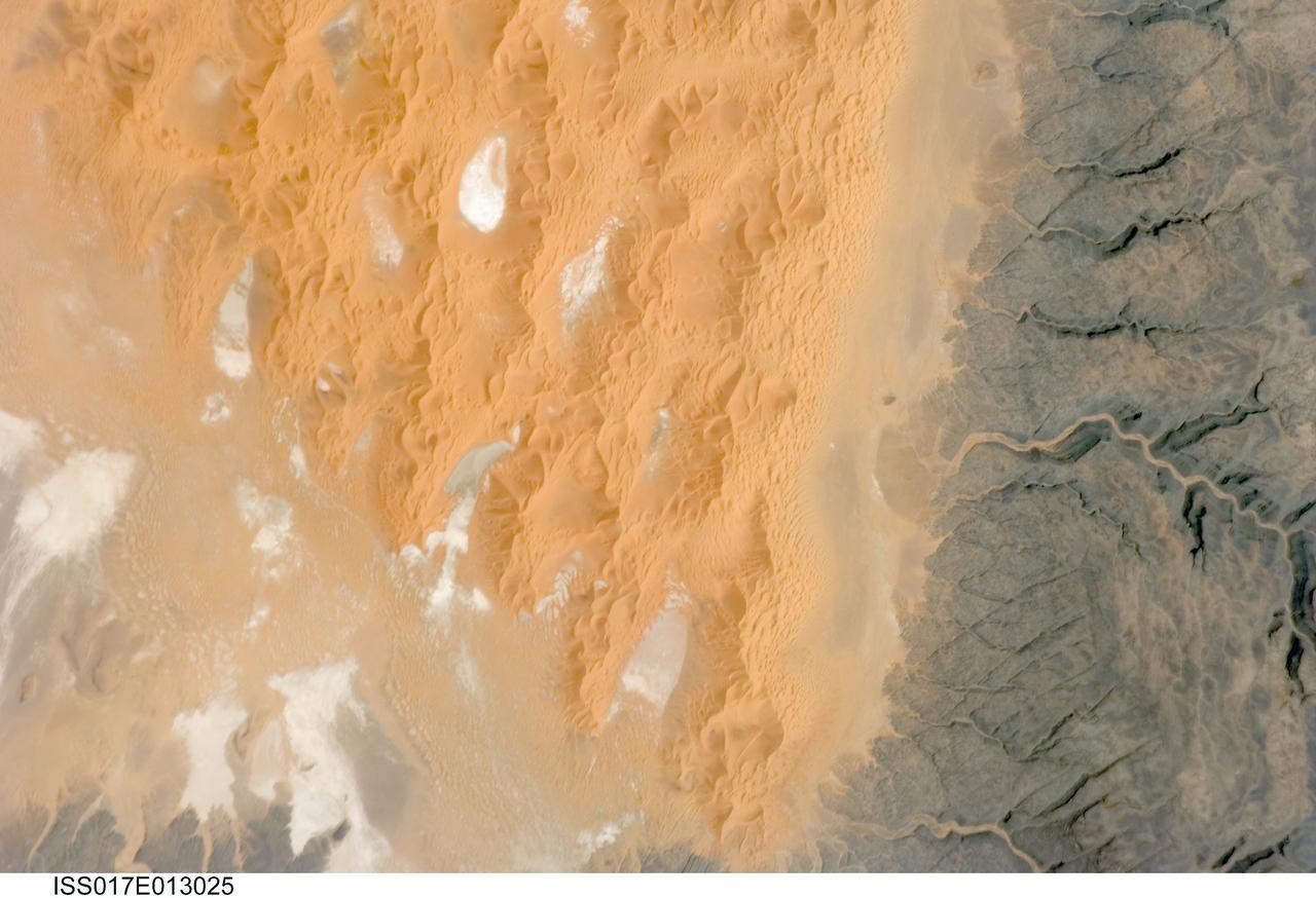
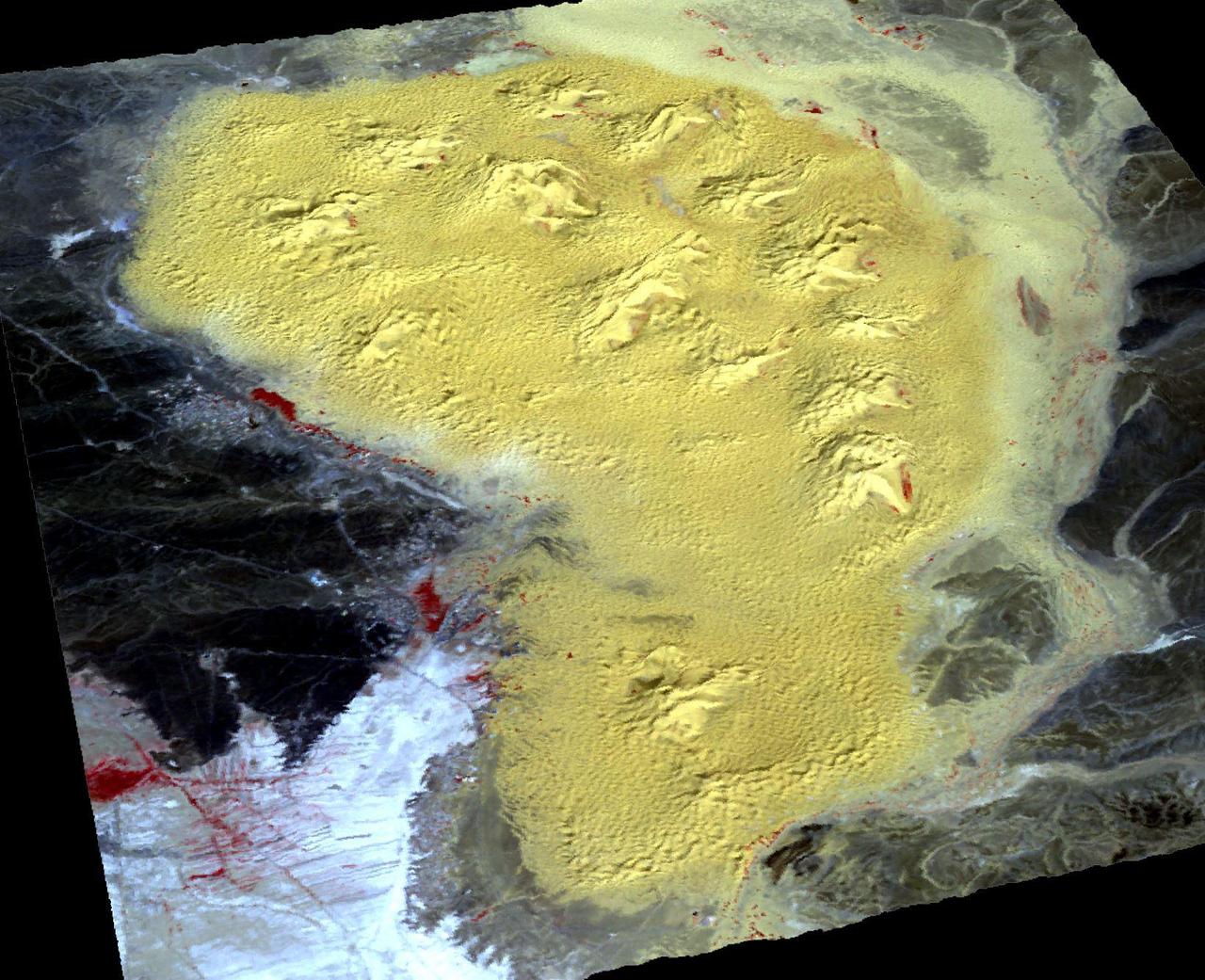
ISS017-E-013025 (12 Aug. 2008) --- The Tifernine Dune Field in Algeria is featured in this image photographed by an Expedition 17 crewmember on the International Space Station. The Tifernine Dune Field is located at the southernmost tip of the Grand Erg Oriental, a "dune sea" that occupies a large portion of the Sahara Desert in eastern Algeria. This view illustrates the interface between the yellow-orange sand dunes of the field and adjacent dark brown consolidated rocks of the Tinrhert Plateau to the south and east (right). NASA scientists point out that three distinct landform types are visible in the image, each providing information about past and present climate in the area. The oldest landform is represented by the rocks of the Tinrhert Plateau, which are characterized by a number of incised channels in the bedrock -- these formed during a wet and cool climate period, most probably by glacial meltwater streams. As the present dry and hot climate that characterizes the Sahara became established, water ceased to flow in these channels, and large amounts of drying sediment (sand, silt, and clay) were eroded and transported by predominantly northeast-southwest winds -- forming large linear dunes that roughly parallel the prevailing wind direction (center). The present climate regime is still hot and dry, but current wind directions are more variable, leading to the formation of star dunes -- recognizable by a starfish-like pattern when seem from above -- that are modifying the older large linear dunes. White to grey regions within the dune field are exposed deposits of silt and clay, together with evaporite minerals (such as halite, or common table salt) formed by evaporation of water that collected in small basins between the dunes.
This VIS image of Olympia Undae was collected at the middle of north polar summer. The density of dunes and the alignments of the dune crests varies with location, controlled by the amount of available sand and the predominant winds over time. Olympia Undae is a vast dune field in the north polar region of Mars. It consists of a broad sand sea or erg that partly rings the north polar cap from about 120° to 240°E longitude and 78° to 83°N latitude. The dune field covers an area of approximately 470,000 km2 (bigger than California, smaller than Texas). Olympia Undae is the largest continuous dune field on Mars. Olympia Undae is not the only dune field near the north polar cap, several other smaller fields exist in the same latitude, but in other ranges of longitude, e.g. Abolos and Siton Undae. Barchan and transverse dune forms are the most common. In regions with limited available sand individual barchan dunes will form, the surface beneath and between the dunes is visible. In regions with large sand supplies, the sand sheet covers the underlying surface, and dune forms are found modifying the surface of the sand sheet. In this case transverse dunes are more common. Barchan dunes "point" down wind, transverse dunes are more linear and form parallel to the wind direction. The "square" shaped transverse dunes in Olympia Undae are due to two prevailing wind directions. Orbit Number: 88180 Latitude: 80.9111 Longitude: 135.309 Instrument: VIS Captured: 2021-10-31 01:32 https://photojournal.jpl.nasa.gov/catalog/PIA25158
This VIS image of Olympia Undae was collected during north polar spring. The dunes are still partially covered by the winter frosts; as the region heats up the frost will dissipate to reveal the dark sand beneath. The density of dunes and the alignments of the dune crests varies with location, controlled by the amount of available sand and the predominant winds over time. Olympia Undae is a vast dune field in the north polar region of Mars. It consists of a broad sand sea or erg that partly rings the north polar cap from about 120° to 240°E longitude and 78° to 83°N latitude. The dune field covers an area of approximately 470,000 km2 (bigger than California, smaller than Texas). Olympia Undae is the largest continuous dune field on Mars. Olympia Undae is not the only dune field near the north polar cap, several other smaller fields exist in the same latitude, but in other ranges of longitude, e.g. Abolos and Siton Undae. Barchan and transverse dune forms are the most common. In regions with limited available sand individual barchan dunes will form, the surface beneath and between the dunes is visible. In regions with large sand supplies, the sand sheet covers the underlying surface, and dune forms are found modifying the surface of the sand sheet. In this case transverse dunes are more common. Barchan dunes "point" down wind, transverse dunes are more linear and form parallel to the wind direction. The "square" shaped transverse dunes in Olympia Undae are due to two prevailing wind directions. Orbit Number: 94436 Latitude: 80.4194 Longitude: 227.978 Instrument: VIS Captured: 2023-03-30 04:29 https://photojournal.jpl.nasa.gov/catalog/PIA26028
Olympia Undae is a vast dune field in the north polar region of Mars. It consists of a broad sand sea or erg that partly rings the north polar cap from about 120° to 240°E longitude and 78° to 83°N latitude. The dune field covers an area of approximately 470,000 km2 (bigger than California, smaller than Texas). Olympia Undae is the largest continuous dune field on Mars. Olympia Undae is not the only dune field near the north polar cap, several other smaller fields exist in the same latitude, but in other ranges of longitude, e.g. Abolos and Siton Undae. Barchan and transverse dune forms are the most common. In regions with limited available sand individual barchan dunes will form, the surface beneath and between the dunes is visible. In regions with large sand supplies, the sand sheet covers the underlying surface, and dune forms are found modifying the surface of the sand sheet. In this case transverse dunes are more common. Barchan dunes "point" down wind, transverse dunes are more linear and form parallel to the wind direction. The "square" shaped transverse dunes in Olympia Undae are due to two prevailing wind directions. The Odyssey spacecraft has spent over 15 years in orbit around Mars, circling the planet more than 71,000 times. It holds the record for longest working spacecraft at Mars. THEMIS, the IR/VIS camera system, has collected data for the entire mission and provides images covering all seasons and lighting conditions. Over the years many features of interest have received repeated imaging, building up a suite of images covering the entire feature. From the deepest chasma to the tallest volcano, individual dunes inside craters and dune fields that encircle the north pole, channels carved by water and lava, and a variety of other feature, THEMIS has imaged them all. For the next several months the image of the day will focus on the Tharsis volcanoes, the various chasmata of Valles Marineris, and the major dunes fields. We hope you enjoy these images! Orbit Number: 27652 Latitude: 80.983 Longitude: 170.458 Instrument: VIS Captured: 2008-03-09 04:03 https://photojournal.jpl.nasa.gov/catalog/PIA22288
This VIS image of Olympia Undae was collected during north polar summer. The density of dunes and the alignments of the dune crests varies with location, controlled by the amount of available sand and the predominant winds over time. Olympia Undae is a vast dune field in the north polar region of Mars. It consists of a broad sand sea or erg that partly rings the north polar cap from about 120° to 240°E longitude and 78° to 83°N latitude. The dune field covers an area of approximately 470,000 km2 (bigger than California, smaller than Texas). Olympia Undae is the largest continuous dune field on Mars. Olympia Undae is not the only dune field near the north polar cap, several other smaller fields exist in the same latitude, but in other ranges of longitude, e.g. Abolos and Siton Undae. Barchan and transverse dune forms are the most common. In regions with limited available sand individual barchan dunes will form, the surface beneath and between the dunes is visible. In regions with large sand supplies, the sand sheet covers the underlying surface, and dune forms are found modifying the surface of the sand sheet. In this case transverse dunes are more common. Barchan dunes "point" down wind, transverse dunes are more linear and form parallel to the wind direction. The "square" shaped transverse dunes in Olympia Undae are due to two prevailing wind directions. Orbit Number: 88192 Latitude: 81.2425 Longitude: 148.338 Instrument: VIS Captured: 2021-11-01 01:15 https://photojournal.jpl.nasa.gov/catalog/PIA25192
This VIS image of Olympia Undae was collected at the start of north polar spring. The dune crests have not yet lost the winter frosts, which still cover the dark sand beneath. The density of dunes and the alignments of the dune crests varies with location, controlled by the amount of available sand and the predominant winds over time. Olympia Undae is a vast dune field in the north polar region of Mars. It consists of a broad sand sea or erg that partly rings the north polar cap from about 120° to 240°E longitude and 78° to 83°N latitude. The dune field covers an area of approximately 470,000 km2 (bigger than California, smaller than Texas). Olympia Undae is the largest continuous dune field on Mars. Olympia Undae is not the only dune field near the north polar cap, several other smaller fields exist in the same latitude, but in other ranges of longitude, e.g. Abolos and Siton Undae. Barchan and transverse dune forms are the most common. In regions with limited available sand individual barchan dunes will form, the surface beneath and between the dunes is visible. In regions with large sand supplies, the sand sheet covers the underlying surface, and dune forms are found modifying the surface of the sand sheet. In this case transverse dunes are more common. Barchan dunes "point" down wind, transverse dunes are more linear and form parallel to the wind direction. The "square" shaped transverse dunes in Olympia Undae are due to two prevailing wind directions. Orbit Number: 93875 Latitude: 81.2131 Longitude: 213.454 Instrument: VIS Captured: 2023-02-11 23:53 https://photojournal.jpl.nasa.gov/catalog/PIA25908
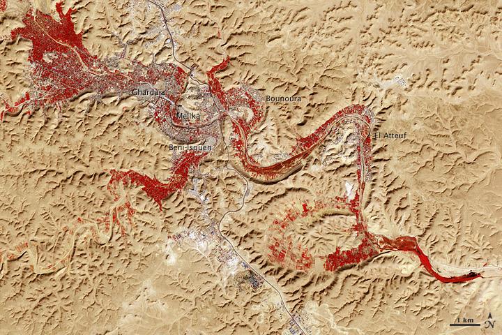
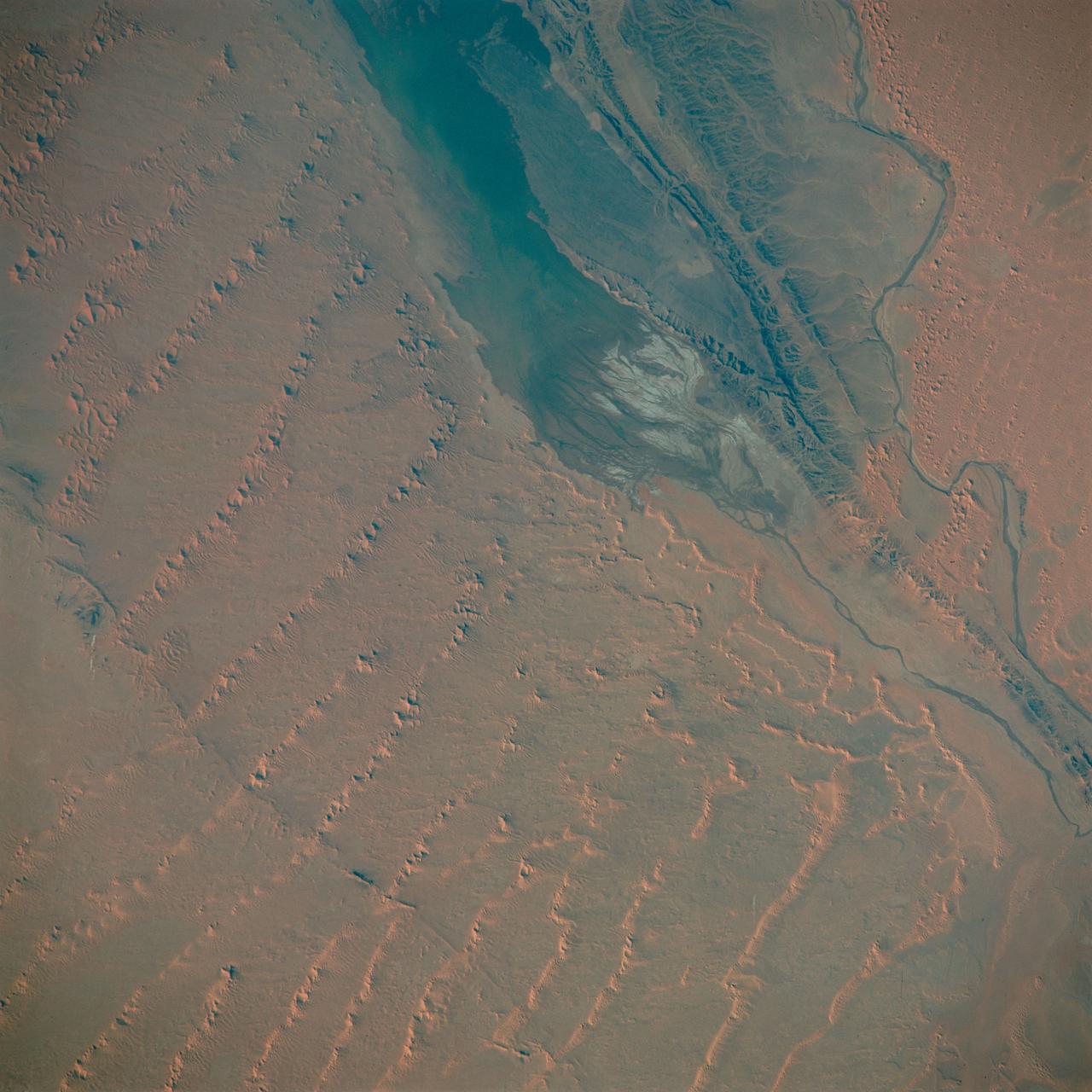
NASA image acquired Feb. 9, 2011 Less than 5 percent of Algeria’s land surface is suitable for growing crops, and most precipitation falls on the Atlas Mountains along the coast. Inland, dust-laden winds blow over rocky plains and sand seas. However, in north central Algeria—off the tip of Grand Erg Occidental and about 450 kilometers (280 miles) south of Algiers—lies a serpentine stretch of vegetation. It is the M’zab Valley, filled with palm groves and dotted with centuries-old settlements. The Advanced Spaceborne Thermal Emission and Reflection Radiometer (ASTER) on NASA’s Terra satellite captured this image of M’zab Valley on February 9, 2011. ASTER combines infrared, red, and green wavelengths of light. Bare rock ranges in color from beige to peach. Buildings and paved surfaces appear gray. Vegetation is red, and brighter shades of red indicate more robust vegetation. This oasis results from water that is otherwise in short supply in the Sahara Desert, thanks to the valley’s approximately 3,000 wells. Chemical analysis of Algerian aquifers, as well studies of topography in Algeria and Tunisia, suggest this region experienced a cooler climate in the late Pleistocene, and potentially heavy monsoon rains earlier in the Holocene. The M’zab region shows evidence of meandering rivers and pinnate drainage patterns. The vegetation lining M’zab Valley highlights this old river valley’s contours. Cool summer temperatures and monsoon rains had long since retreated from the region by eleventh century, but this valley nevertheless supported the establishment of multiple fortified settlements, or ksours. Between 1012 A.D. and 1350 A.D., locals established the ksours of El-Atteuf, Bounoura, Melika, Ghardaïa, and Beni-Isguen. Collectively these cities are now a United Nations Educational, Scientific, and Cultural Organization (UNESCO) World Heritage site. NASA Earth Observatory image by Robert Simmon and Jesse Allen, using data from the GSFC/METI/ERSDAC/JAROS, and U.S./Japan ASTER Science Team. Caption by Michon Scott. Instrument: Terra - ASTER <b>To download the full high res file go <a href="http://earthobservatory.nasa.gov/IOTD/view.php?id=51296" rel="nofollow"> here</a></b>
This VIS image of Olympia Undae was collected during north polar summer. Olympia Undae is a vast dune field in the north polar region of Mars. It consists of a broad sand sea or erg that partly rings the north polar cap from about 120° to 240°E longitude and 78° to 83°N latitude. The dune field covers an area of approximately 470,000 km2 (bigger than California, smaller than Texas). Olympia Undae is the largest continuous dune field on Mars. Olympia Undae is not the only dune field near the north polar cap, several other smaller fields exist in the same latitude, but in other ranges of longitude, e.g. Abolos and Siton Undae. Barchan and transverse dune forms are the most common. In regions with limited available sand individual barchan dunes will form, the surface beneath and between the dunes is visible. In regions with large sand supplies, the sand sheet covers the underlying surface, and dune forms are found modifying the surface of the sand sheet. In this case transverse dunes are more common. Barchan dunes "point" down wind, transverse dunes are more linear and form parallel to the wind direction. The "square" shaped transverse dunes in Olympia Undae are due to two prevailing wind directions. Orbit Number: 80440 Latitude: 80.7922 Longitude: 225.187 Instrument: VIS Captured: 2020-02-01 18:23 https://photojournal.jpl.nasa.gov/catalog/PIA23833
This VIS image of Olympia Undae was collected during north polar summer. The density of dunes and the alignments of the dune crests varies with location, controlled by the amount of available sand and the predominant winds over time. Olympia Undae is a vast dune field in the north polar region of Mars. It consists of a broad sand sea or erg that partly rings the north polar cap from about 120° to 240°E longitude and 78° to 83°N latitude. The dune field covers an area of approximately 470,000 km2 (bigger than California, smaller than Texas). Olympia Undae is the largest continuous dune field on Mars. Olympia Undae is not the only dune field near the north polar cap, several other smaller fields exist in the same latitude, but in other ranges of longitude, e.g. Abolos and Siton Undae. Barchan and transverse dune forms are the most common. In regions with limited available sand individual barchan dunes will form, the surface beneath and between the dunes is visible. In regions with large sand supplies, the sand sheet covers the underlying surface, and dune forms are found modifying the surface of the sand sheet. In this case transverse dunes are more common. Barchan dunes "point" down wind, transverse dunes are more linear and form parallel to the wind direction. Transverse dunes cover the top half of this image. Orbit Number: 80092 Latitude: 81.4474 Longitude: 183.52 Instrument: VIS Captured: 2020-01-04 02:42 https://photojournal.jpl.nasa.gov/catalog/PIA23751
This VIS image of Olympia Undae was collected at the beginning of north polar spring. As the season changes into springtime, the dune crests still show most of the winter frosts completely covering the darker sand beneath. The density of dunes and the alignments of the dune crests varies with location, controlled by the amount of available sand and the predominant winds over time. Olympia Undae is a vast dune field in the north polar region of Mars. It consists of a broad sand sea or erg that partly rings the north polar cap from about 120° to 240°E longitude and 78° to 83°N latitude. The dune field covers an area of approximately 470,000 km2 (bigger than California, smaller than Texas). Olympia Undae is the largest continuous dune field on Mars. Olympia Undae is not the only dune field near the north polar cap, several other smaller fields exist in the same latitude, but in other ranges of longitude, e.g. Abolos and Siton Undae. Barchan and transverse dune forms are the most common. In regions with limited available sand individual barchan dunes will form, the surface beneath and between the dunes is visible. In regions with large sand supplies, the sand sheet covers the underlying surface, and dune forms are found modifying the surface of the sand sheet. In this case transverse dunes are more common. Barchan dunes "point" down wind, transverse dunes are more linear and form parallel to the wind direction. The "square" shaped transverse dunes in Olympia Undae are due to two prevailing wind directions. Orbit Number: 85881 Latitude: 81.5324 Longitude: 216.986 Instrument: VIS Captured: 2021-04-24 18:26 https://photojournal.jpl.nasa.gov/catalog/PIA24882
This VIS image of Olympia Undae was collected at the start polar spring. As the season changes into springtime, the dune crests are just starting to shed the winter frosts which completely hide the darker sand beneath. The density of dunes and the alignments of the dune crests varies with location, controlled by the amount of available sand and the predominant winds over time. Olympia Undae is a vast dune field in the north polar region of Mars. It consists of a broad sand sea or erg that partly rings the north polar cap from about 120° to 240°E longitude and 78° to 83°N latitude. The dune field covers an area of approximately 470,000 km2 (bigger than California, smaller than Texas). Olympia Undae is the largest continuous dune field on Mars. Olympia Undae is not the only dune field near the north polar cap, several other smaller fields exist in the same latitude, but in other ranges of longitude, e.g. Abolos and Siton Undae. Barchan and transverse dune forms are the most common. In regions with limited available sand individual barchan dunes will form, the surface beneath and between the dunes is visible. In regions with large sand supplies, the sand sheet covers the underlying surface, and dune forms are found modifying the surface of the sand sheet. In this case transverse dunes are more common. Barchan dunes "point" down wind, transverse dunes are more linear and form parallel to the wind direction. The "square" shaped transverse dunes in Olympia Undae are due to two prevailing wind directions. Orbit Number: 85826 Latitude: 80.894 Longitude: 222.032 Instrument: VIS Captured: 2021-04-20 05:51 https://photojournal.jpl.nasa.gov/catalog/PIA24878
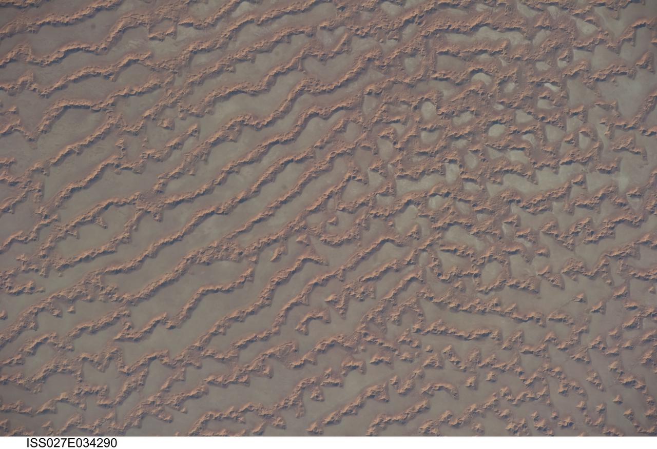
ISS027-E-034290 (16 May 2011) --- Ar Rub al Khali Sand Sea, Arabian Peninsula is featured in this image photographed by an Expedition 27 crew member on the International Space Station. The Ar Rub al Khali, also known as the “Empty Quarter”, is a large region of sand dunes and interdune flats known as a sand sea (or erg). This photograph highlights a part of the Ar Rub al Khali located close to its southeastern margin in the Sultanate of Oman. Reddish-brown, large linear sand dunes alternate with blue-gray interdune salt flats known as sabkhas at left. The major trend of the linear dunes is transverse to northwesterly trade winds that originate in Iraq (known as the Shamal winds). Formation of secondary barchan (crescent-shaped) and star dunes (dune crests in several directions originating from a single point, looking somewhat like a starfish from above) on the linear dunes is supported by southwesterly winds that occur during the monsoon season (Kharif winds). The long linear dunes begin to break up into isolated large star dunes to the northeast and east (right). This is likely a result of both wind pattern interactions and changes in the sand supply to the dunes. The Empty Quarter covers much of the south-central portion of the Arabian Peninsula, and with an area of approximately 660,000 square kilometers it is the largest continuous sand desert on Earth. The Empty Quarter is so called as the dominantly hyperarid climate and difficulty of travel through the dunes has not encouraged permanent settlement within the region. There is geological and archeological evidence to support cooler and wetter past climates in the region together with human settlement. This evidence includes exposed lakebed sediments, scattered stone tools, and the fossils of hippopotamus, water buffalo, and long-horned cattle.
This VIS image of Olympia Undae was collected during north polar spring. The dunes are still partially covered by the winter frosts; as the region heats up the frost will dissipate to reveal the dark sand beneath. The density of dunes and the alignments of the dune crests varies with location, controlled by the amount of available sand and the predominant winds over time. Olympia Undae is a vast dune field in the north polar region of Mars. It consists of a broad sand sea or erg that partly rings the north polar cap from about 120° to 240°E longitude and 78° to 83°N latitude. The dune field covers an area of approximately 470,000 km2 (bigger than California, smaller than Texas). Olympia Undae is the largest continuous dune field on Mars. Olympia Undae is not the only dune field near the north polar cap, several other smaller fields exist in the same latitude, but in other ranges of longitude, e.g. Abolos and Siton Undae. Barchan and transverse dune forms are the most common. In regions with limited available sand individual barchan dunes will form, the surface beneath and between the dunes is visible. In regions with large sand supplies, the sand sheet covers the underlying surface, and dune forms are found modifying the surface of the sand sheet. In this case transverse dunes are more common. Barchan dunes "point" down wind, transverse dunes are more linear and form parallel to the wind direction. The "square" shaped transverse dunes in Olympia Undae are due to two prevailing wind directions. Orbit Number: 94624 Latitude: 80.6784 Longitude: 204.452 Instrument: VIS Captured: 2023-04-14 15:59 https://photojournal.jpl.nasa.gov/catalog/PIA26039
This VIS image of Olympia Undae was collected in the middle of north polar spring. As the season changes into summertime, the dune crests will lose all the winter frosts, completely revealing the darker sand beneath. The density of dunes and the alignments of the dune crests varies with location, controlled by the amount of available sand and the predominant winds over time. Olympia Undae is a vast dune field in the north polar region of Mars. It consists of a broad sand sea or erg that partly rings the north polar cap from about 120° to 240°E longitude and 78° to 83°N latitude. The dune field covers an area of approximately 470,000 km2 (bigger than California, smaller than Texas). Olympia Undae is the largest continuous dune field on Mars. Olympia Undae is not the only dune field near the north polar cap, several other smaller fields exist in the same latitude, but in other ranges of longitude, e.g. Abolos and Siton Undae. Barchan and transverse dune forms are the most common. In regions with limited available sand individual barchan dunes will form, the surface beneath and between the dunes is visible. In regions with large sand supplies, the sand sheet covers the underlying surface, and dune forms are found modifying the surface of the sand sheet. In this case transverse dunes are more common. Barchan dunes "point" down wind, transverse dunes are more linear and form parallel to the wind direction. The "square" shaped transverse dunes in Olympia Undae are due to two prevailing wind directions. Orbit Number: 86712 Latitude: 80.9536 Longitude: 222.236 Instrument: VIS Captured: 2021-07-02 04:40 https://photojournal.jpl.nasa.gov/catalog/PIA24991
This VIS image of Olympia Undae was collected early in north polar spring. The dunes are still covered by the winter frosts; as the region heats up the frost will dissipate to reveal the dark sand beneath. The density of dunes and the alignments of the dune crests varies with location, controlled by the amount of available sand and the predominant winds over time. Olympia Undae is a vast dune field in the north polar region of Mars. It consists of a broad sand sea or erg that partly rings the north polar cap from about 120° to 240°E longitude and 78° to 83°N latitude. The dune field covers an area of approximately 470,000 km2 (bigger than California, smaller than Texas). Olympia Undae is the largest continuous dune field on Mars. Olympia Undae is not the only dune field near the north polar cap, several other smaller fields exist in the same latitude, but in other ranges of longitude, e.g. Abolos and Siton Undae. Barchan and transverse dune forms are the most common. In regions with limited available sand individual barchan dunes will form, the surface beneath and between the dunes is visible. In regions with large sand supplies, the sand sheet covers the underlying surface, and dune forms are found modifying the surface of the sand sheet. In this case transverse dunes are more common. Barchan dunes "point" down wind, transverse dunes are more linear and form parallel to the wind direction. The "square" shaped transverse dunes in Olympia Undae are due to two prevailing wind directions. Orbit Number: 93727 Latitude: 79.5915 Longitude: 159.786 Instrument: VIS Captured: 2023-01-30 19:25 https://photojournal.jpl.nasa.gov/catalog/PIA25874
This VIS image highlights the dune form/dune density aspects of Olypmia Undae. In the center there is a brighter, diagonal region of few dunes. These dunes are the arc or crescent shape of barchan dunes. As more sand becomes available the barchan dunes begin to merge into transverse dunes. The region of dunes surrounding the bright swath still have the underlying surface visible, and the transverse dunes have a lace-like layout. In the regions with a significant abundance of sand have developed the tightly packed transverse dunes with the wave-like distribution. Olympia Undae is a vast dune field in the north polar region of Mars. It consists of a broad sand sea or erg that partly rings the north polar cap from about 120° to 240°E longitude and 78° to 83°N latitude. The dune field covers an area of approximately 470,000 km2 (bigger than California, smaller than Texas). Olympia Undae is the largest continuous dune field on Mars. Olympia Undae is not the only dune field near the north polar cap, several other smaller fields exist in the same latitude, but in other ranges of longitude, e.g. Abolos and Siton Undae. Barchan and transverse dune forms are the most common. In regions with limited available sand individual barchan dunes will form, the surface beneath and between the dunes is visible. In regions with large sand supplies, the sand sheet covers the underlying surface, and dune forms are found modifying the surface of the sand sheet. In this case transverse dunes are more common. Barchan dunes "point" down wind, transverse dunes are more linear and form parallel to the wind direction. The "square" shaped transverse dunes in Olympia Undae are due to two prevailing wind directions. The density of dunes and the alignments of the dune crests varies with location, controlled by the amount of available sand and the predominant winds over time. The Odyssey spacecraft has spent over 15 years in orbit around Mars, circling the planet more than 71,000 times. It holds the record for longest working spacecraft at Mars. THEMIS, the IR/VIS camera system, has collected data for the entire mission and provides images covering all seasons and lighting conditions. Over the years many features of interest have received repeated imaging, building up a suite of images covering the entire feature. From the deepest chasma to the tallest volcano, individual dunes inside craters and dune fields that encircle the north pole, channels carved by water and lava, and a variety of other feature, THEMIS has imaged them all. For the next several months the image of the day will focus on the Tharsis volcanoes, the various chasmata of Valles Marineris, and the major dunes fields. We hope you enjoy these images! Orbit Number: 13238 Latitude: 80.7247 Longitude: 173.91 Instrument: VIS Captured: 2004-12-08 09:25 https://photojournal.jpl.nasa.gov/catalog/PIA22296

This VIS image of Olympia Undae was collected early in north polar spring. The crests of the dunes are light colored, indicative of a frost covering. As the season changes into summertime, the dune crests will lose the frost and reveal the darker sand beneath. The margin of the north polar cap is visible at the top of the image. Olympia Undae is a vast dune field in the north polar region of Mars. It consists of a broad sand sea or erg that partly rings the north polar cap from about 120° to 240°E longitude and 78° to 83°N latitude. The dune field covers an area of approximately 470,000 km2 (bigger than California, smaller than Texas). Olympia Undae is the largest continuous dune field on Mars. Olympia Undae is not the only dune field near the north polar cap, several other smaller fields exist in the same latitude, but in other ranges of longitude, e.g. Abolos and Siton Undae. Barchan and transverse dune forms are the most common. In regions with limited available sand individual barchan dunes will form, the surface beneath and between the dunes is visible. In regions with large sand supplies, the sand sheet covers the underlying surface, and dune forms are found modifying the surface of the sand sheet. In this case transverse dunes are more common. Barchan dunes "point" down wind, transverse dunes are more linear and form parallel to the wind direction. The "square" shaped transverse dunes in Olympia Undae are due to two prevailing wind directions. The Odyssey spacecraft has spent over 15 years in orbit around Mars, circling the planet more than 71,000 times. It holds the record for longest working spacecraft at Mars. THEMIS, the IR/VIS camera system, has collected data for the entire mission and provides images covering all seasons and lighting conditions. Over the years many features of interest have received repeated imaging, building up a suite of images covering the entire feature. From the deepest chasma to the tallest volcano, individual dunes inside craters and dune fields that encircle the north pole, channels carved by water and lava, and a variety of other feature, THEMIS has imaged them all. For the next several months the image of the day will focus on the Tharsis volcanoes, the various chasmata of Valles Marineris, and the major dunes fields. We hope you enjoy these images! Orbit Number: 10293 Latitude: 83.0224 Longitude: 174.743 Instrument: VIS Captured: 2004-04-09 22:04 https://photojournal.jpl.nasa.gov/catalog/PIA22289
ISS013-E-65526 (8 Aug. 2006) --- Issaouane Dune Sea, Eastern Algeria is featured in this image photographed by an Expedition 13 crewmember on the International Space Station. This view from one of the smaller dune seas in the central Sahara shows the complex but regular patterns produced by winds in deserts where abundant sand is available. Geologists now know that dune seas (also called ergs) comprise at least three orders of dune size. In this image the largest and oldest appear here as chains oriented about 60 degrees apart, that is, one oriented almost north-south, the other southwest-northeast. The "streets" between the dune chains (also called mega-dunes) are swept clean of sand in places, revealing the original surface, with light colored muds and salt derived from very occasional rains. The chains have probably taken hundreds of thousands of years to accumulate, starting when the Sahara began to become significantly dry roughly 2.5 million years ago. Rivers became smaller, failed to reach the sea and deposited their sand load in the desert. Wind did the rest, blowing the sand into aerodynamic dune forms. According to scientists, chain trends coincide with two of the four major trends identified in the Great Eastern Sand Sea immediately to the north. Each trend likely implies a different formative wind direction--attesting to the climate shifts that have occurred since sand began to accumulate in the central Sahara. Smaller dunes are superimposed on the mega-dunes. Sinuous crest lines are the mesoscale (intermediate in size) forms, forming octopus-like crests, especially evident as the arms of star dunes. Whereas the mega-dunes are apparently stationary, studies based on aerial photographs in other parts of the world show that these dune crests move in the course of decades. The smallest dunes appear in patches on the eastern sides of the mega-dunes as a tracery of closely spaced crests. Small dunes move fast and reform quickly as stronger winds shift with the seasons. Sand grains are blown continuously from upwind dunes, across the dune-free flats. Small dunes form when the grains slow down and accumulate at the next large dune. The small dunes ride up and over the backs of the mega- and meso-dunes. Interestingly the crest orientation of the small dunes is different from that of the mesoscale dunes throughout the image. This is a common effect of wind direction shifting locally depending on dune height: the increased friction caused by larger dunes causes formative winds to blow to the left of the (weaker) winds that form the small dunes. The friction effect of larger dunes is to the right in the southern hemisphere, well illustrated on the coast of the Namib Desert.

This VIS image of Olympia Undae was collected early in north polar spring. The crests of the dunes are light colored, indicative of a frost covering. As the season changes into summertime, the dune crests will lose the frost and reveal the darker sand beneath. The linear nature of transverse dunes can be seen at the bottom of the image. The density of dunes and the alignments of the dune crests varies with location, controlled by the amount of available sand and the predominant winds over time. Olympia Undae is a vast dune field in the north polar region of Mars. It consists of a broad sand sea or erg that partly rings the north polar cap from about 120° to 240°E longitude and 78° to 83°N latitude. The dune field covers an area of approximately 470,000 km2 (bigger than California, smaller than Texas). Olympia Undae is the largest continuous dune field on Mars. Olympia Undae is not the only dune field near the north polar cap, several other smaller fields exist in the same latitude, but in other ranges of longitude, e.g. Abolos and Siton Undae. Barchan and transverse dune forms are the most common. In regions with limited available sand individual barchan dunes will form, the surface beneath and between the dunes is visible. In regions with large sand supplies, the sand sheet covers the underlying surface, and dune forms are found modifying the surface of the sand sheet. In this case transverse dunes are more common. Barchan dunes "point" down wind, transverse dunes are more linear and form parallel to the wind direction. The "square" shaped transverse dunes in Olympia Undae are due to two prevailing wind directions. The Odyssey spacecraft has spent over 15 years in orbit around Mars, circling the planet more than 71,000 times. It holds the record for longest working spacecraft at Mars. THEMIS, the IR/VIS camera system, has collected data for the entire mission and provides images covering all seasons and lighting conditions. Over the years many features of interest have received repeated imaging, building up a suite of images covering the entire feature. From the deepest chasma to the tallest volcano, individual dunes inside craters and dune fields that encircle the north pole, channels carved by water and lava, and a variety of other feature, THEMIS has imaged them all. For the next several months the image of the day will focus on the Tharsis volcanoes, the various chasmata of Valles Marineris, and the major dunes fields. We hope you enjoy these images! Orbit Number: 10380 Latitude: 79.7273 Longitude: 176.363 Instrument: VIS Captured: 2004-04-17 02:00 https://photojournal.jpl.nasa.gov/catalog/PIA22290

This VIS image of Olympia Undae was collected during north polar spring. The crests of the dunes and other surfaces are light colored, indicative of a frost covering. At the top right of the image is a region of smooth surfaces. This is the ejecta from Jojutla Crater. The ejecta is a higher elevation than the rest of the surface, and dunes are "climbing" or "skirting" the ejecta regions. The density of dunes and the alignments of the dune crests varies with location, controlled by the amount of available sand and the predominant winds over time, and, in this case, the presence of different surface elevations. As the season changes into summertime, the dune crests will lose the frost and reveal the darker sand beneath. This loss of frost is just starting to be visible at the bottom of the image. Olympia Undae is a vast dune field in the north polar region of Mars. It consists of a broad sand sea or erg that partly rings the north polar cap from about 120° to 240°E longitude and 78° to 83°N latitude. The dune field covers an area of approximately 470,000 km2 (bigger than California, smaller than Texas). Olympia Undae is the largest continuous dune field on Mars. Olympia Undae is not the only dune field near the north polar cap, several other smaller fields exist in the same latitude, but in other ranges of longitude, e.g. Abolos and Siton Undae. Barchan and transverse dune forms are the most common. In regions with limited available sand individual barchan dunes will form, the surface beneath and between the dunes is visible. In regions with large sand supplies, the sand sheet covers the underlying surface, and dune forms are found modifying the surface of the sand sheet. In this case transverse dunes are more common. Barchan dunes "point" down wind, transverse dunes are more linear and form parallel to the wind direction. The "square" shaped transverse dunes in Olympia Undae are due to two prevailing wind directions. The Odyssey spacecraft has spent over 15 years in orbit around Mars, circling the planet more than 71,000 times. It holds the record for longest working spacecraft at Mars. THEMIS, the IR/VIS camera system, has collected data for the entire mission and provides images covering all seasons and lighting conditions. Over the years many features of interest have received repeated imaging, building up a suite of images covering the entire feature. From the deepest chasma to the tallest volcano, individual dunes inside craters and dune fields that encircle the north pole, channels carved by water and lava, and a variety of other feature, THEMIS has imaged them all. For the next several months the image of the day will focus on the Tharsis volcanoes, the various chasmata of Valles Marineris, and the major dunes fields. We hope you enjoy these images! Orbit Number: 27352 Latitude: 80.9139 Longitude: 185.126 Instrument: VIS Captured: 2008-02-13 11:10 https://photojournal.jpl.nasa.gov/catalog/PIA22291

This VIS image of Olympia Undae was collected during north polar summer. The dunes are now completely frost free and are dark in color due to being made of basaltic sand. The surface between the dunes, where visible, is a bright tone. In some regions of dense dunes, the bright material may be a deposit on the dunes rather than the underlying surface. The presence of gypsum has been suggested for Olympia Undae, gypsum is a lighter tone than basalt in this filter of the THEMIS VIS camera. Olympia Undae is a vast dune field in the north polar region of Mars. It consists of a broad sand sea or erg that partly rings the north polar cap from about 120° to 240°E longitude and 78° to 83°N latitude. The dune field covers an area of approximately 470,000 km2 (bigger than California, smaller than Texas). Olympia Undae is the largest continuous dune field on Mars. Olympia Undae is not the only dune field near the north polar cap, several other smaller fields exist in the same latitude, but in other ranges of longitude, e.g. Abolos and Siton Undae. Barchan and transverse dune forms are the most common. In regions with limited available sand individual barchan dunes will form, the surface beneath and between the dunes is visible. In regions with large sand supplies, the sand sheet covers the underlying surface, and dune forms are found modifying the surface of the sand sheet. In this case transverse dunes are more common. Barchan dunes "point" down wind, transverse dunes are more linear and form parallel to the wind direction. The "square" shaped transverse dunes in Olympia Undae are due to two prevailing wind directions. The density of dunes and the alignments of the dune crests varies with location, controlled by the amount of available sand and the predominant winds over time. The Odyssey spacecraft has spent over 15 years in orbit around Mars, circling the planet more than 71,000 times. It holds the record for longest working spacecraft at Mars. THEMIS, the IR/VIS camera system, has collected data for the entire mission and provides images covering all seasons and lighting conditions. Over the years many features of interest have received repeated imaging, building up a suite of images covering the entire feature. From the deepest chasma to the tallest volcano, individual dunes inside craters and dune fields that encircle the north pole, channels carved by water and lava, and a variety of other feature, THEMIS has imaged them all. For the next several months the image of the day will focus on the Tharsis volcanoes, the various chasmata of Valles Marineris, and the major dunes fields. We hope you enjoy these images! Orbit Number: 12614 Latitude: 80.8745 Longitude: 174.688 Instrument: VIS Captured: 2004-10-18 00:23 https://photojournal.jpl.nasa.gov/catalog/PIA22293

This VIS image was collected at the height of summer. It is during this season that winds are able to move sand sized particles, slowly modifying the dunes. Olympia Undae is a vast dune field in the north polar region of Mars. It consists of a broad sand sea or erg that partly rings the north polar cap from about 120° to 240°E longitude and 78° to 83°N latitude. The dune field covers an area of approximately 470,000 km2 (bigger than California, smaller than Texas). Olympia Undae is the largest continuous dune field on Mars. Olympia Undae is not the only dune field near the north polar cap, several other smaller fields exist in the same latitude, but in other ranges of longitude, e.g. Abolos and Siton Undae. Barchan and transverse dune forms are the most common. In regions with limited available sand individual barchan dunes will form, the surface beneath and between the dunes is visible. In regions with large sand supplies, the sand sheet covers the underlying surface, and dune forms are found modifying the surface of the sand sheet. In this case transverse dunes are more common. Barchan dunes "point" down wind, transverse dunes are more linear and form parallel to the wind direction. The "square" shaped transverse dunes in Olympia Undae are due to two prevailing wind directions. The density of dunes and the alignments of the dune crests varies with location, controlled by the amount of available sand and the predominant winds over time. The Odyssey spacecraft has spent over 15 years in orbit around Mars, circling the planet more than 71,000 times. It holds the record for longest working spacecraft at Mars. THEMIS, the IR/VIS camera system, has collected data for the entire mission and provides images covering all seasons and lighting conditions. Over the years many features of interest have received repeated imaging, building up a suite of images covering the entire feature. From the deepest chasma to the tallest volcano, individual dunes inside craters and dune fields that encircle the north pole, channels carved by water and lava, and a variety of other feature, THEMIS has imaged them all. For the next several months the image of the day will focus on the Tharsis volcanoes, the various chasmata of Valles Marineris, and the major dunes fields. We hope you enjoy these images! Orbit Number: 13475 Latitude: 80.7459 Longitude: 177.171 Instrument: VIS Captured: 2004-12-27 21:44 https://photojournal.jpl.nasa.gov/catalog/PIA22297
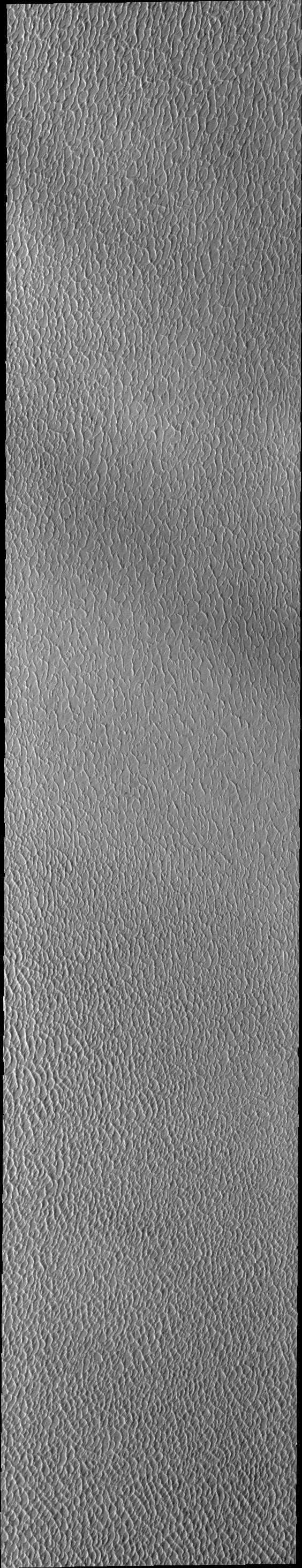
This VIS image of Olympia Undae was collected during north polar spring. The crests of the dunes and other surfaces are light colored, indicative of a frost covering. The density of dunes and the alignments of the dune crests varies with location, controlled by the amount of available sand and the predominant winds over time. As the season changes into summertime, the dune crests will lose the frost and reveal the darker sand beneath. Olympia Undae is a vast dune field in the north polar region of Mars. It consists of a broad sand sea or erg that partly rings the north polar cap from about 120° to 240°E longitude and 78° to 83°N latitude. The dune field covers an area of approximately 470,000 km2 (bigger than California, smaller than Texas). Olympia Undae is the largest continuous dune field on Mars. Olympia Undae is not the only dune field near the north polar cap, several other smaller fields exist in the same latitude, but in other ranges of longitude, e.g. Abolos and Siton Undae. Barchan and transverse dune forms are the most common. In regions with limited available sand individual barchan dunes will form, the surface beneath and between the dunes is visible. In regions with large sand supplies, the sand sheet covers the underlying surface, and dune forms are found modifying the surface of the sand sheet. In this case transverse dunes are more common. Barchan dunes "point" down wind, transverse dunes are more linear and form parallel to the wind direction. The "square" shaped transverse dunes in Olympia Undae are due to two prevailing wind directions. The Odyssey spacecraft has spent over 15 years in orbit around Mars, circling the planet more than 71,000 times. It holds the record for longest working spacecraft at Mars. THEMIS, the IR/VIS camera system, has collected data for the entire mission and provides images covering all seasons and lighting conditions. Over the years many features of interest have received repeated imaging, building up a suite of images covering the entire feature. From the deepest chasma to the tallest volcano, individual dunes inside craters and dune fields that encircle the north pole, channels carved by water and lava, and a variety of other feature, THEMIS has imaged them all. For the next several months the image of the day will focus on the Tharsis volcanoes, the various chasmata of Valles Marineris, and the major dunes fields. We hope you enjoy these images! Orbit Number: 27402 Latitude: 81.2035 Longitude: 183.317 Instrument: VIS Captured: 2008-02-17 13:59 https://photojournal.jpl.nasa.gov/catalog/PIA22292
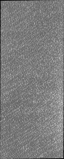
This VIS image of Olympia Undae was collected during north polar summer. The dunes are now completely frost free and are dark in color due to being made of basaltic sand. The surface between the dunes, where visible, is a bright tone. In some regions of dense dunes, the bright material may be a deposit on the dunes rather than the underlying surface. The presence of gypsum has been suggested for Olympia Undae, gypsum is a lighter tone than basalt in this filter of the THEMIS VIS camera. Olympia Undae is a vast dune field in the north polar region of Mars. It consists of a broad sand sea or erg that partly rings the north polar cap from about 120° to 240°E longitude and 78° to 83°N latitude. The dune field covers an area of approximately 470,000 km2 (bigger than California, smaller than Texas). Olympia Undae is the largest continuous dune field on Mars. Olympia Undae is not the only dune field near the north polar cap, several other smaller fields exist in the same latitude, but in other ranges of longitude, e.g. Abolos and Siton Undae. Barchan and transverse dune forms are the most common. In regions with limited available sand individual barchan dunes will form, the surface beneath and between the dunes is visible. In regions with large sand supplies, the sand sheet covers the underlying surface, and dune forms are found modifying the surface of the sand sheet. In this case transverse dunes are more common. Barchan dunes "point" down wind, transverse dunes are more linear and form parallel to the wind direction. The "square" shaped transverse dunes in Olympia Undae are due to two prevailing wind directions. The density of dunes and the alignments of the dune crests varies with location, controlled by the amount of available sand and the predominant winds over time. The Odyssey spacecraft has spent over 15 years in orbit around Mars, circling the planet more than 71,000 times. It holds the record for longest working spacecraft at Mars. THEMIS, the IR/VIS camera system, has collected data for the entire mission and provides images covering all seasons and lighting conditions. Over the years many features of interest have received repeated imaging, building up a suite of images covering the entire feature. From the deepest chasma to the tallest volcano, individual dunes inside craters and dune fields that encircle the north pole, channels carved by water and lava, and a variety of other feature, THEMIS has imaged them all. For the next several months the image of the day will focus on the Tharsis volcanoes, the various chasmata of Valles Marineris, and the major dunes fields. We hope you enjoy these images! Orbit Number: 21125 Latitude: 81.5387 Longitude: 181.591 Instrument: VIS Captured: 2006-09-18 18:07 https://photojournal.jpl.nasa.gov/catalog/PIA22294
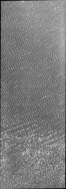
This VIS image of Olympia Undae was collected during north polar summer. The dunes are now completely frost free and are dark in color due to being made of basaltic sand. The surface between the dunes, where visible, is a bright tone. In some regions of dense dunes, the bright material may be a deposit on the dunes rather than the underlying surface. The presence of gypsum has been suggested for Olympia Undae, gypsum is a lighter tone than basalt in this filter of the THEMIS VIS camera. This VIS image hightlights the density of dunes, the bottom third of the image has fewer dunes, spaced farther apart than the top two thirds of the image. The bottom of the image "looks" like lace, while the top with the dense dunes with aligned dune crests "looks" like waves in an ocean. The term used for dune fields on Mar is undae (unda singular). This term translates from Latin as water waves and is used to mean undulatory in planetary nomenclature. All non-Earth dune fields in the solar system are called unda/undae. Olympia Undae is a vast dune field in the north polar region of Mars. It consists of a broad sand sea or erg that partly rings the north polar cap from about 120° to 240°E longitude and 78° to 83°N latitude. The dune field covers an area of approximately 470,000 km2 (bigger than California, smaller than Texas). Olympia Undae is the largest continuous dune field on Mars. Olympia Undae is not the only dune field near the north polar cap, several other smaller fields exist in the same latitude, but in other ranges of longitude, e.g. Abolos and Siton Undae. Barchan and transverse dune forms are the most common. In regions with limited available sand individual barchan dunes will form, the surface beneath and between the dunes is visible. In regions with large sand supplies, the sand sheet covers the underlying surface, and dune forms are found modifying the surface of the sand sheet. In this case transverse dunes are more common. Barchan dunes "point" down wind, transverse dunes are more linear and form parallel to the wind direction. The "square" shaped transverse dunes in Olympia Undae are due to two prevailing wind directions. The density of dunes and the alignments of the dune crests varies with location, controlled by the amount of available sand and the predominant winds over time. The Odyssey spacecraft has spent over 15 years in orbit around Mars, circling the planet more than 71,000 times. It holds the record for longest working spacecraft at Mars. THEMIS, the IR/VIS camera system, has collected data for the entire mission and provides images covering all seasons and lighting conditions. Over the years many features of interest have received repeated imaging, building up a suite of images covering the entire feature. From the deepest chasma to the tallest volcano, individual dunes inside craters and dune fields that encircle the north pole, channels carved by water and lava, and a variety of other feature, THEMIS has imaged them all. For the next several months the image of the day will focus on the Tharsis volcanoes, the various chasmata of Valles Marineris, and the major dunes fields. We hope you enjoy these images! Orbit Number: 13138 Latitude: 80.8321 Longitude: 178.781 Instrument: VIS Captured: 2004-11-30 03:49 https://photojournal.jpl.nasa.gov/catalog/PIA22295