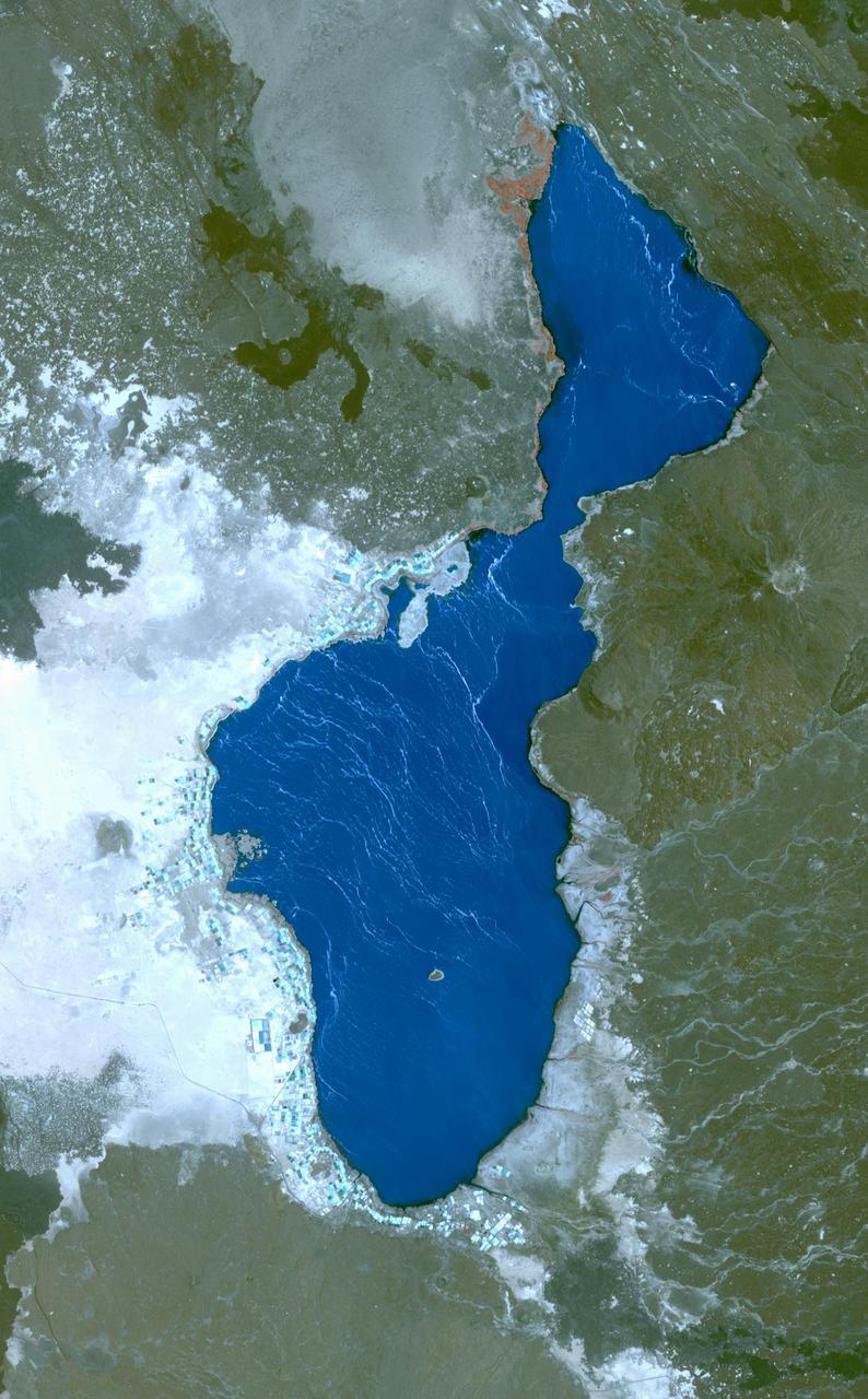
Lake Afrera is a hypersaline lake located in the Danakil Depression in northern Ethiopia where rock salt has been mined for centuries. This image was acquired by NASA Terra spacecraft.
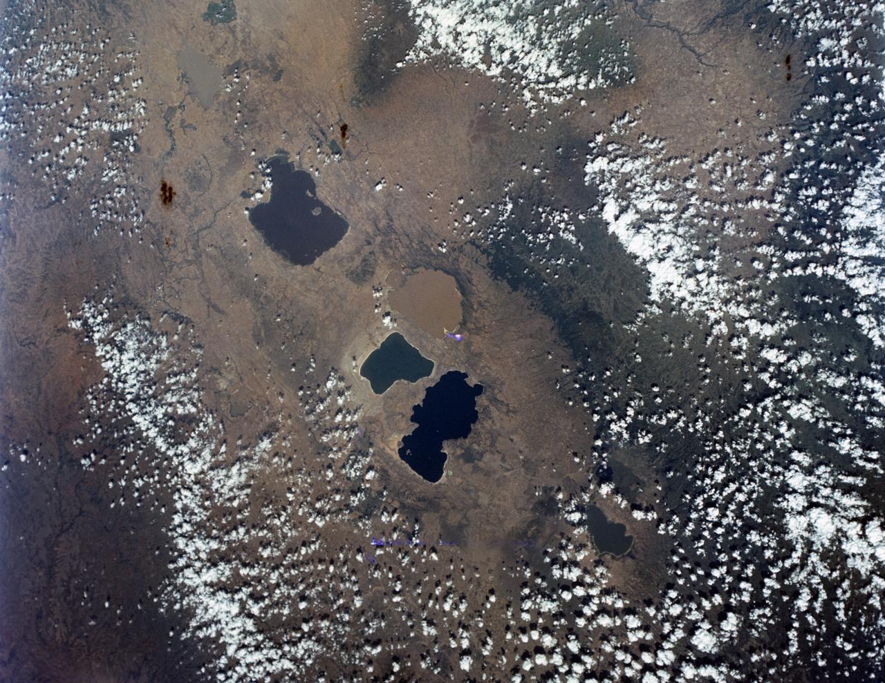
S65-63162 (16 Dec. 1965) --- Central area of Ethiopia, south of Addis Ababa, showing Lakes Zwai, Langana, and Shala, as seen from the Gemini-6 spacecraft during its 14th revolution of Earth. Photo credit: NASA or National Aeronautics and Space Administration
ASTER succeeded in acquiring this image at night, which is something Visible/Near Infrared VNIR) and Shortwave Infrared (SWIR) sensors cannot do. The scene covers the Red Sea coastline to an inland area of Ethiopia. White pixels represent areas with higher temperature material on the surface, while dark pixels indicate lower temperatures. This image shows ASTER's ability as a highly sensitive, temperature-discerning instrument and the first spaceborne TIR multi-band sensor in history. The size of image: 60 km x 60 km approx., ground resolution 90 m x 90 m approximately. http://photojournal.jpl.nasa.gov/catalog/PIA02452
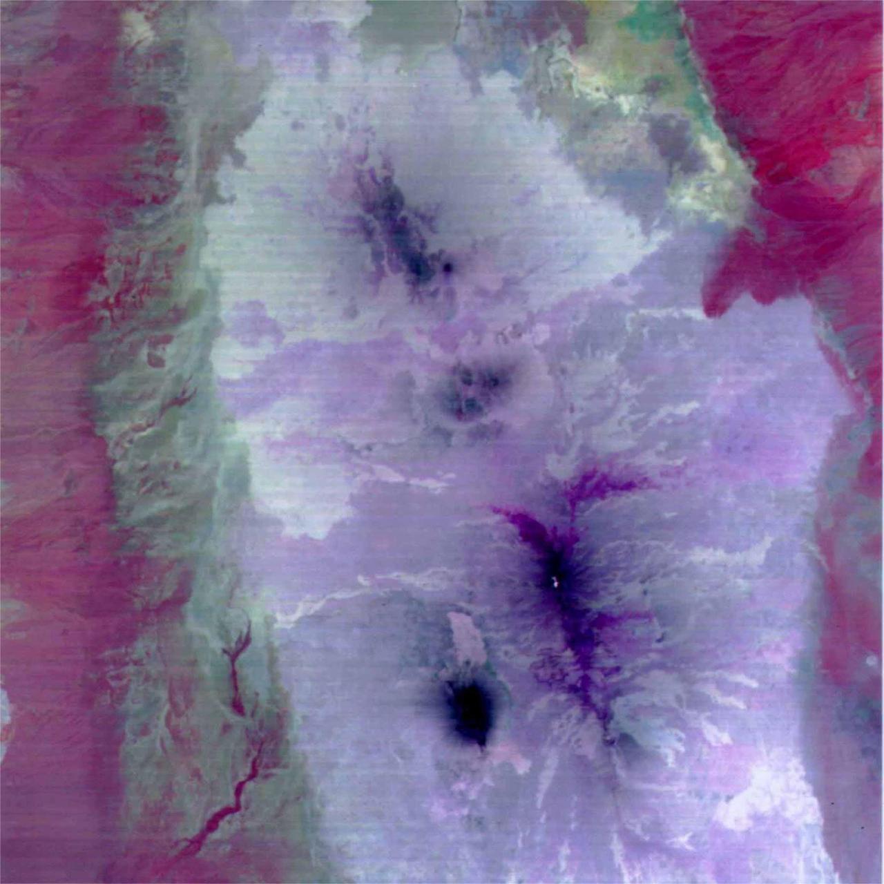
This image is a color composite covering the Rift Valley inland area of Ethiopia (south of the region shown in PIA02452). The color difference of this image reflects the distribution of different rocks with different amounts of silicon dioxide. It is inferred that the area with whitish color is covered with basalt and the pinkish area in the center contain sandesite. This is the first spaceborne, multi-band TIR image in history that enables geologists to distinguish between rocks with similar compositions. The size of image: 60 km x 60 km approx., ground resolution 90 m x 90 m approximately. http://photojournal.jpl.nasa.gov/catalog/PIA02453
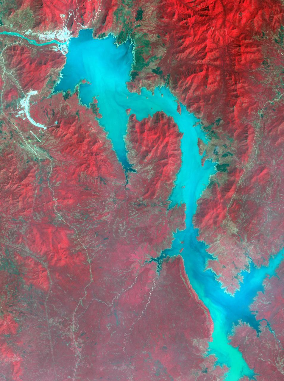
Filling of the Grand Ethiopian Renaissance Dam (GERD) along the Blue Nile River is well under way near the Ethiopia-Sudan border. For a decade, Egypt and Ethiopia have been at a diplomatic stalemate over the Nile's management. Egypt proposes that Ethiopia should be able to generate hydropower from the GERD while minimizing the harm on downstream communities in Egypt and Sudan. Ethiopia's objective is to assert control over the Blue Nile, the largest tributary of the Nile River. The image was acquired November 6, 2020, covers an area of 32 by 42.9 kilometers, and is located near 11.1 degrees north, 35.2 degrees east. https://photojournal.jpl.nasa.gov/catalog/PIA24150
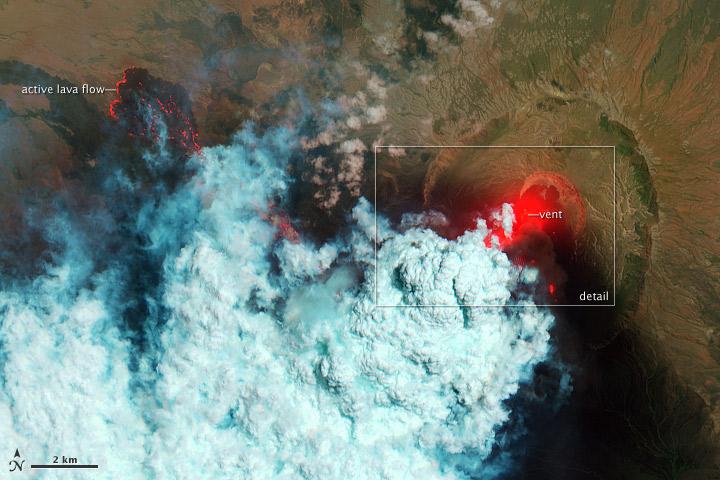
This image of Africa Nabro volcano in Eritrea was acquired by NASA Terra spacecraft on July 6, 2011. Ash plumes sent into the stratosphere disrupted air traffic in Sudan, Djibouti, Ethiopia and Sudan.
iss062e103426 (March 20, 2020) --- The Shebelle River in Ethiopia us pictured as the International Space Station orbited 258 miles above the African continent.
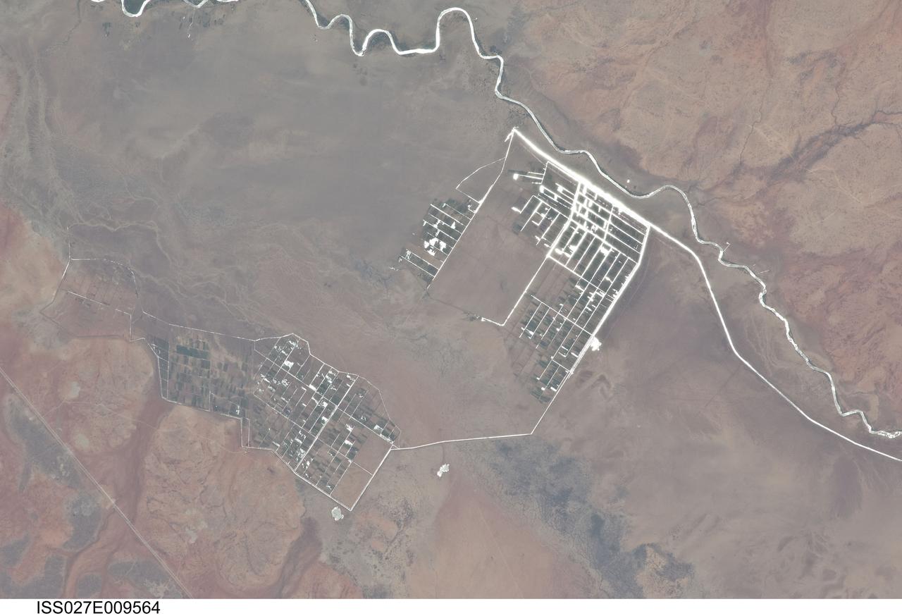
ISS027-E-009564 (31 March 2011) --- Agricultural fields along the Shebelle River in Ethiopia are featured in this image photographed by an Expedition 27 crew member on the International Space Station. The Shebelle River supports limited agricultural development within the arid to semi-arid Ogaden Plateau region of southeastern Ethiopia. This detailed photograph illustrates a network of irrigation canals and fields located approximately 42 kilometers to the west-northwest of the city of Gode, Ethiopia. Floodplain sediments and soils are dark brown to gray (center), and contrast with reddish rocks and soils of the adjacent plateau. Water in the Shebelle River, and the irrigation canals, has a bright, mirror-like appearance due to sunglint, or light reflecting off the water surface back towards the observer on the space station. Vegetation in the floodplain (bottom center) and agricultural fields is dark green. The river water supports a variety of crops?the most common being sorghum and maize?as well as grazing for livestock (cattle, sheep, goats, and camels). The Shebelle River has its headwaters in the Ethiopian Highlands, and transports water and sediment 1,000 kilometers to the southeast across Ethiopia, continuing an additional 130 kilometers into neighboring Somalia. The Shebelle River does not reach the Indian Ocean during most years, but disappears into the sands near the coast in Somalia. During periods of heavy rainfall and flooding however, the Shebelle can reach the Indian Ocean.
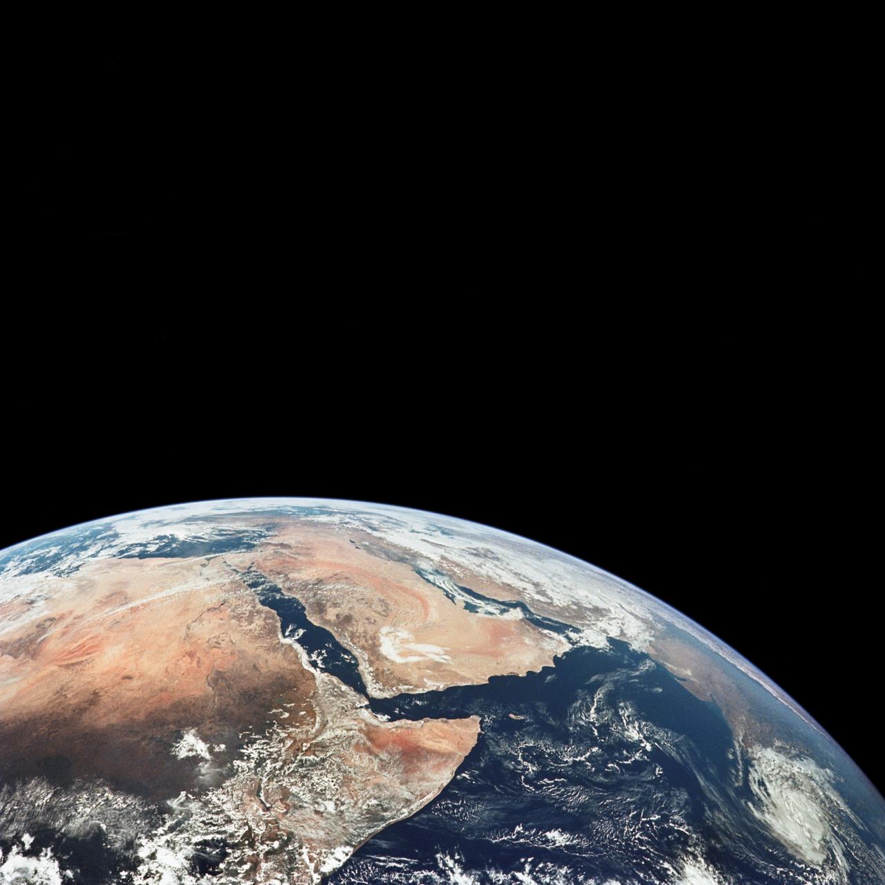
AS17-148-22718 (7-19 Dec. 1972) --- This excellent view of Saudi Arabia and the north eastern portion of the African continent was photographed by the Apollo 17 astronauts with a hand-held camera on their trans-lunar coast toward man's last lunar visit. Egypt, Sudan, Ethiopia are some of the African nations are visible. Iran, Iraq, Jordan are not so clearly visible because of cloud cover and their particular location in the picture. India is dimly visible at right of frame. The Red Sea is seen entirely in this one single frame, a rare occurrence in Apollo photography or any photography taken from manned spacecraft. The Gulf of Suez, the Dead Sea, Gulf of Aden, Persian Gulf and Gulf of Oman are also visible. This frame is one of 169 frames on film magazine NN carried aboard Apollo 17, all of which are SO368 (color) film. A 250mm lens on a 70mm Hasselblad camera recorded the image, one of 92 taken during the trans-lunar coast. Note AS17-148-22727 (also magazine NN) for an excellent full Earth picture showing the entire African continent.
iss067e301767 (Aug. 31, 2022) --- Lake Tana, Ethiopia's largest lake, and Dek Island are pictured from the International Space Station as it orbited 258 miles above the African nation.
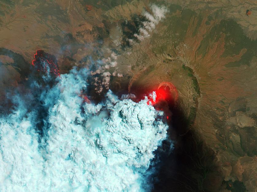
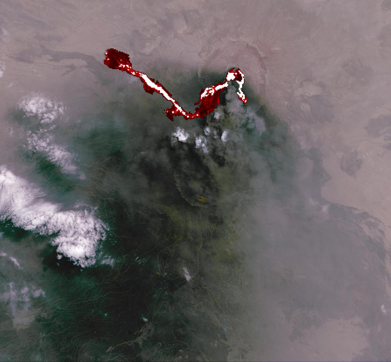
NASA image acquired June 24, 2011 Since it began erupting on June 12, 2011, emissions from Eritrea’s Nabro Volcano have drifted over much of East Africa and the Middle East. Ash has displaced residents living near the volcano and disrupted flights in the region. Despite the volcano’s widespread effects, little is known about the eruption. Nabro is located in an isolated region along the border between Eritrea and Ethiopia, and few English-language reports have been published. Satellite remote sensing is currently the only reliable way to monitor the ongoing eruption. This satellite image is among the first detailed pictures of the erupting vent and lava flows. They were acquired by the Advanced Land Imager (ALI) aboard the Earth Observing-1 (EO-1) satellite on June 24, 2011. The bright red portions of the false-color image (top) indicate hot surfaces. Hot volcanic ash glows above the vent, located in the center of Nabro’s caldera. To the west of the vent, portions of an active lava flow (particularly the front of the flow) are also hot. The speckled pattern on upstream portions of the flow are likely due to the cool, hardened crust splitting and exposing fluid lava as the flow advances. The bulbous blue-white cloud near the vent is likely composed largely of escaping water vapor that condensed as the plume rose and cooled. The whispy, cyan clouds above the lava flow are evidence of degassing from the lava. NASA Earth Observatory image by Robert Simmon, using EO-1 ALI data. Caption by Robert Simmon. Instrument: EO-1 - ALI To download the high res go here: <a href="http://earthobservatory.nasa.gov/IOTD/view.php?id=51216" rel="nofollow">earthobservatory.nasa.gov/IOTD/view.php?id=51216</a> <b><a href="http://www.nasa.gov/centers/goddard/home/index.html" rel="nofollow">NASA Goddard Space Flight Center</a></b> enables NASA’s mission through four scientific endeavors: Earth Science, Heliophysics, Solar System Exploration, and Astrophysics. Goddard plays a leading role in NASA’s accomplishments by contributing compelling scientific knowledge to advance the Agency’s mission. <b>Follow us on <a href="http://twitter.com/NASA_GoddardPix" rel="nofollow">Twitter</a></b> <b>Like us on <a href="http://www.facebook.com/pages/Greenbelt-MD/NASA-Goddard/395013845897?ref=tsd" rel="nofollow">Facebook</a></b> <b>Find us on <a href="http://web.stagram.com/n/nasagoddard/?vm=grid" rel="nofollow">Instagram</a></b>
NASA image acquired June 24, 2011 Since it began erupting on June 12, 2011, emissions from Eritrea’s Nabro Volcano have drifted over much of East Africa and the Middle East. Ash has displaced residents living near the volcano and disrupted flights in the region. Despite the volcano’s widespread effects, little is known about the eruption. Nabro is located in an isolated region along the border between Eritrea and Ethiopia, and few English-language reports have been published. Satellite remote sensing is currently the only reliable way to monitor the ongoing eruption. This satellite image is among the first detailed pictures of the erupting vent and lava flows. They were acquired by the Advanced Land Imager (ALI) aboard the Earth Observing-1 (EO-1) satellite on June 24, 2011. The bright red portions of the false-color image (top) indicate hot surfaces. Hot volcanic ash glows above the vent, located in the center of Nabro’s caldera. To the west of the vent, portions of an active lava flow (particularly the front of the flow) are also hot. The speckled pattern on upstream portions of the flow are likely due to the cool, hardened crust splitting and exposing fluid lava as the flow advances. The bulbous blue-white cloud near the vent is likely composed largely of escaping water vapor that condensed as the plume rose and cooled. The whispy, cyan clouds above the lava flow are evidence of degassing from the lava. NASA Earth Observatory image by Robert Simmon, using EO-1 ALI data. Caption by Robert Simmon. Instrument: EO-1 - ALI To download the high res go here: <a href="http://earthobservatory.nasa.gov/IOTD/view.php?id=51216" rel="nofollow">earthobservatory.nasa.gov/IOTD/view.php?id=51216</a> <b><a href="http://www.nasa.gov/centers/goddard/home/index.html" rel="nofollow">NASA Goddard Space Flight Center</a></b> enables NASA’s mission through four scientific endeavors: Earth Science, Heliophysics, Solar System Exploration, and Astrophysics. Goddard plays a leading role in NASA’s accomplishments by contributing compelling scientific knowledge to advance the Agency’s mission. <b>Follow us on <a href="http://twitter.com/NASA_GoddardPix" rel="nofollow">Twitter</a></b> <b>Like us on <a href="http://www.facebook.com/pages/Greenbelt-MD/NASA-Goddard/395013845897?ref=tsd" rel="nofollow">Facebook</a></b> <b>Find us on <a href="http://web.stagram.com/n/nasagoddard/?vm=grid" rel="nofollow">Instagram</a></b>
ISS033-E-013636 (20 Oct. 2012) --- One of the Expedition 33 crew members aboard the International Space Station took this oblique photograph showing part of the Red Sea and the Gulf of Aden. Areas that are easily recognized in the picture include parts of Eritrea, Yemen and Ethiopia. Slight haze is also visible.
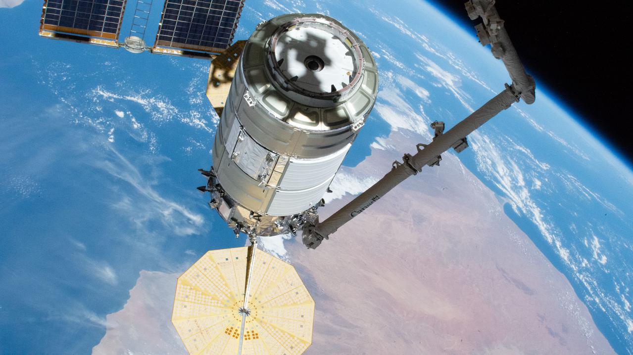
iss064e035920 (Feb. 22, 2021) --- The Cygnus space freighter from Northrop Grumman is maneuvered in the grip of the Canadarm2 robotic arm toward its port on the Unity module where it will stay until late May. The International Space Station was orbiting 262 miles above Ethiopia at the time this photograph was taken.
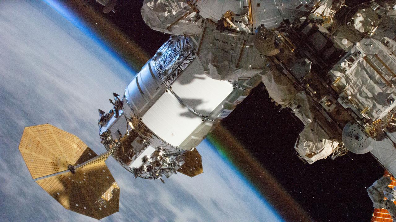
iss064e047042 (March 28, 2021) --- The Cygnus resupply ship, with its prominent cymbal-shaped UltraFlex solar arrays, from Northrop Grumman is pictured attached to the International Space Station's Unity module. Earth's atmospheric glow is seen blanketing the horizon as the orbital complex flew 262 miles above Ethiopia on the African continent.
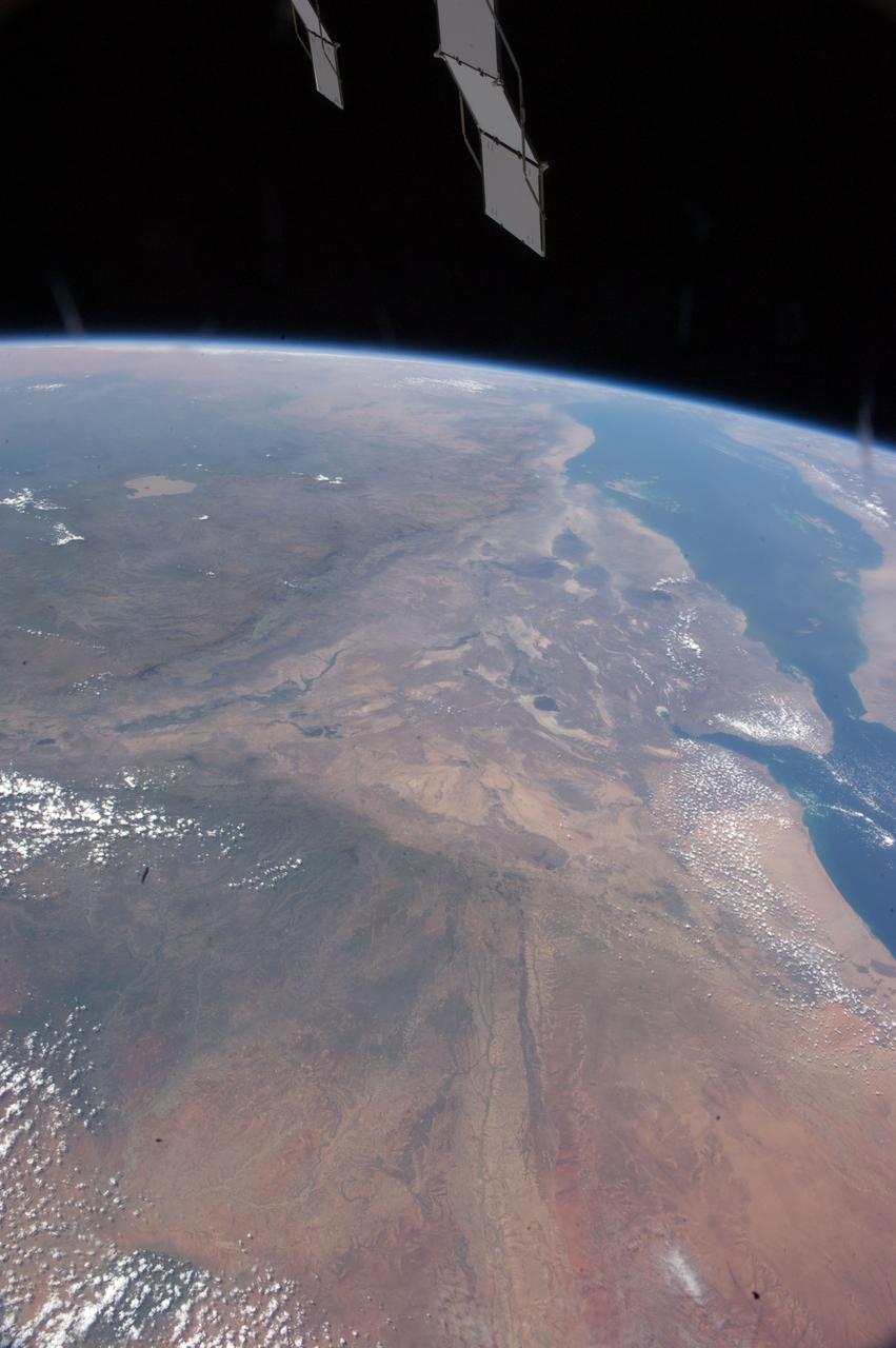
ISS033-E-013632 (20 Oct. 2012) --- This oblique photo of Ethiopia and part of the Red Sea was photographed by one of the Expedition 33 crew members aboard the International Space Station. The name of the funnel-shaped area is the Afar Depression or Afar Triangle. The green body of water is Lake Tana, connected to the Blue Nile.
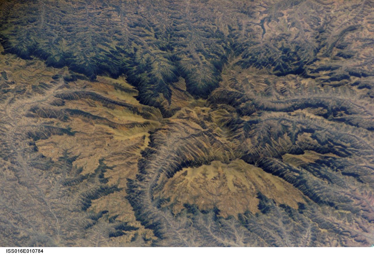
ISS016-E-010784 (16 Nov. 2007) --- Semien Mountains, Gonder, northern Ethiopia are featured in this image photographed by an Expedition 16 crewmember on the International Space Station. The Semien Mountains, the highest parts of the Ethiopian Plateau (above 2,000 meters--6,560 feet), are surrounded by a steep, ragged escarpment (step) with dramatic vertical cliffs, pinnacles, and rock spires - scenery that draws international tourists. Included in the range is the highest point in Ethiopia, Ras Dashen at 4,533 meters (14,926 feet) - an altitude only recently computed with any accuracy. The plateau and surrounding areas are made up of numerous flood basalts, totaling probably more than 3,000 meters in thickness. According to scientists, the lavas erupted quickly (in about one million years) 31 million years ago, as Ethiopia passed above what is known as the Afar "hotspot." The hotspot caused the general region of Ethiopia to be elevated, which encouraged extensive river erosion. This erosion has cut the highly dramatic canyons that ring the plateau. Although the plateau lies in the latitude of the Sahara--Arabia deserts, its great altitude makes for a cool, wet climate. This is shown by light green vegetation, compared with the brown canyons which are hot and dry. The green tinge on the biggest escarpment (trending across the top third of the image) is also vegetation, showing that this part of the escarpment also receives more rain than other parts of the escarpment wall. The Semien Mountains are one of the few places in Africa to regularly receive snow, and they receive plentiful rainfall (more than 1,280 millimeters--55 inches). A major canyon cuts the flatter plateau surface (center), with several more surrounding the plateau. These canyons are hot because they reach low altitudes, more than 2,000 meters below the plateau surface. The Semien Mountains National Park has been declared a World Heritage Site by UNESCO for its rugged beauty. In addition, several extremely rare species are found here, such as the Gelada baboon with its thick coat to protect against the cold; the critically-endangered Walia ibex with long, heavy scimitar-like horns; and the Ethiopian wolf--also known as the Semien jackal, the "most endangered canid."
S66-38423 (6 June 1966) --- The southern tip of the Red Sea area as seen from the Gemini-9A spacecraft during its 43rd revolution of Earth. The Red Sea is at lower left. The Gulf of Aden is in the center of the picture. The land mass at bottom center is Ethiopia. Yemen is at upper center, southwestern tip of Arabian Peninsula. Somalia is the land mass in the background, center of picture. The image was taken with a modified 70mm Hasselblad camera, using Eastman Kodak, Ektachrome MS (S.O. 217) color film. Photo credit: NASA
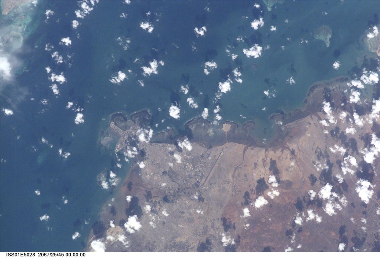
ISS001-E-5028 (December 2000) --- Djibouti, the capital city of the country of Djibouti, can be seen in this northeast-looking view taken from the International Space Station (ISS) with a digital still camera using a 400mm lens. Djibouti, scarcely 100 years old, sits on the western shore of an isthmus in the Gulf of Tadjoura, an arm of the Gulf of Aden. Djibouti is surrounded by a rugged and bleak landscape, that has a dry and hot climate. The population of Djibouti has grown from an estimated 96,000 in 1973 to over 330,000 in 1991 mainly due to the influx of refugees from the neighboring, war torn countries of Ethiopia and Somalia. With its strategically located port, Djibouti’s economic importance results from the large transit trade it enjoys as the terminus of a railroad line from Addis Ababa in Ethiopia. The city has seen an increase in tourism in the past decade due a large number of cruise ships visiting the port. Besides tourism, salt production and shipbuilding and repair are other major industries. Below the center of the image, the long runway of the Djibouti/Ambouli International Airport is visible. Coral reefs are discernible in the upper left and upper right quadrants of the image.
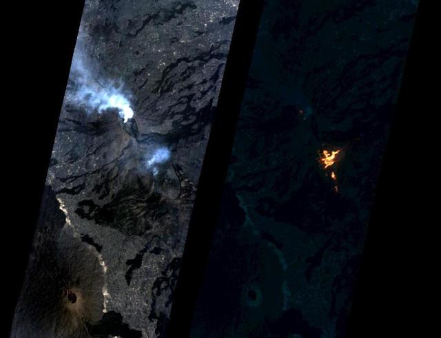
On Jan. 24, 2017, the Hyperion Imager on NASA's Earth Observing 1 (EO-1) spacecraft observed a new eruption at Erta'Ale volcano, Ethiopia, from an altitude of 438 miles (705 kilometers). Data were collected at a resolution of 98 feet (30 meters) per pixel at different visible and infrared wavelengths and were combined to create these images. A visible-wavelength image is on the left. An infrared image is shown on the right. The infrared image emphasizes the hottest areas and reveals a spectacular rift eruption, where a crack opens and lava gushes forth, fountaining into the air. The lava flows spread away from the crack. Erta'Ale is the location of a long-lived lava lake, and it remains to be seen if this survives this new eruption. The observation was scheduled via the Volcano Sensor Web, a network of sensors linked by artificial intelligence software to create an autonomous global monitoring program of satellite observations of volcanoes. The Volcano Sensor Web was alerted to this new activity by data from another spacecraft. http://photojournal.jpl.nasa.gov/catalog/PIA11239
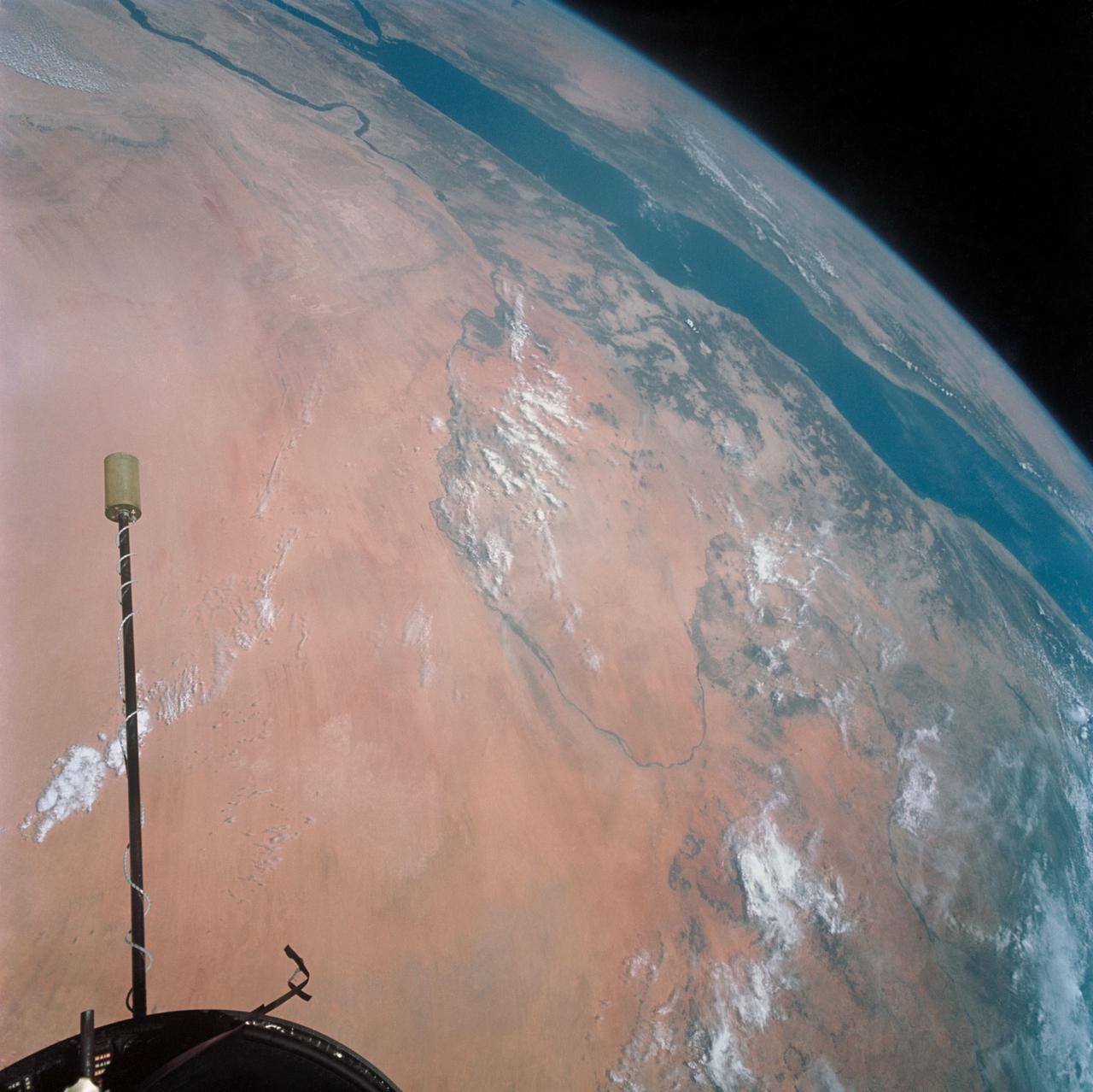
S66-54530 --- Libyan Desert area of Sudan, foreground, and the United Arab Republic (Egypt), at lower left, as seen from the orbiting Gemini-11 spacecraft at an altitude of 300 nautical miles during its 27th revolution of Earth. In view is the Nile River from Biba in Egypt to Khartoum in the Sudan. The Red Sea is in the background. At upper left is the Arabian Peninsula. At top right is Ethiopia. Note L-band antenna of the Agena Target Vehicle. Taken with a modified 70mm Hasselblad camera, using Eastman Kodak, Ektachrome, MS (S.O. 368) color film. Photo credit: NASA
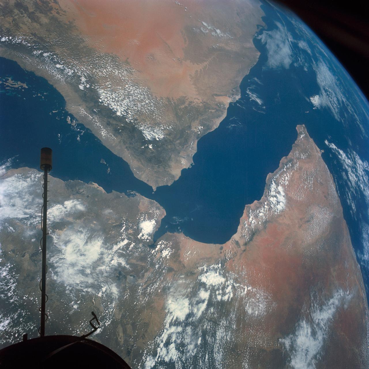
S66-54536 (14 Sept. 1966) --- Arabian Peninsula (on left) and northeast Africa (on right) as seen from the orbiting Gemini-11 spacecraft at an altitude of 340 nautical miles during its 27th revolution of Earth, looking southeast. Saudi Arabia, South Arabia, Yemen, and Aden Protectorate are at left. At bottom right is Ethiopia. French Somaliland is in center on right shore. Somali is at upper right. Body of water at bottom is Red Sea. Gulf of Aden is in center; and at top left is Indian Ocean. Taken with a modified 70mm Hasselblad camera, using Eastman Kodak, Ektachrome, MS (S.O. 368) color film. Photo credit: NASA
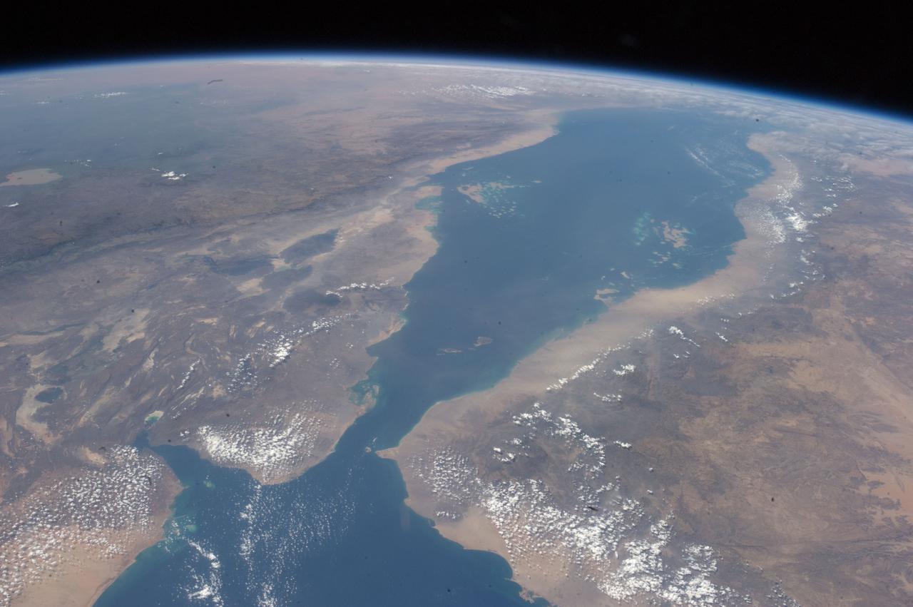
The area known as the Afar Triangle is located at the northern end of the East Africa Rift, where it approaches the southeastern end of the Red Sea and the southwestern end of the Gulf of Aden.

During a Kennedy Space Center (KSC) briefing on the next day’s Apollo 11 launch, Emperor Haile Selassie of Ethiopia (with raised hand) asks a question of Rocco A. Petrone, director of launch operations at KSC. To the right of the emperor is astronaut Gordon Cooper and to his left is Dr. Kurt Debus, director of KSC. The first manned lunar launch occurred at 9:32 am on July 16, 1969. The crew included astronauts Neil A. Armstrong, commander; Michael Collins, Command Module (CM) pilot; and Edwin E. Aldrin Jr., Lunar Module (LM) pilot. After 21/2 hours of collecting samples on the lunar surface, the crew safely splashed down into the Pacific Ocean on July 24, 1969. With the success of Apollo 11, the national objective to land men on the Moon and return them safely to Earth had been accomplished.
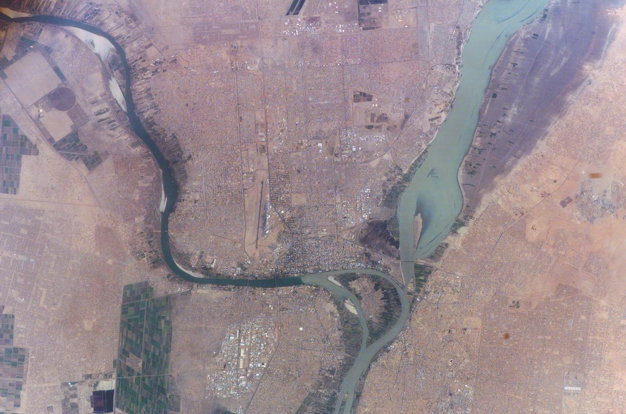
ISS010-E-23451 (7 April 2005) --- Khartoum, Sudan is featured in this image photographed by an Expedition 10 crewmember on the International Space Station (ISS). Sudan’s capital city Khartoum, which means Elephant’s Trunk, describes the shape of the Nile River where the Blue and the White Nile Rivers meet to form the united Nile that flows northward into Egypt. This image shows the rivers near the end of the dry season. The White Nile (western branch) runs through Sudan from Uganda. The White Nile’s equatorial source produces a flow that runs at a nearly constant rate throughout the year. The nearly dry Blue Nile from the highlands of Ethiopia swells in the late summer and early fall with rains from the summer monsoons. The flow can be so great the Nile flows backward at the junction. In recent years, floods in Khartoum have occurred in August with heavy monsoon rainfall. Khartoum is one of the largest Muslim cities in North Africa, but has a fairly short history.
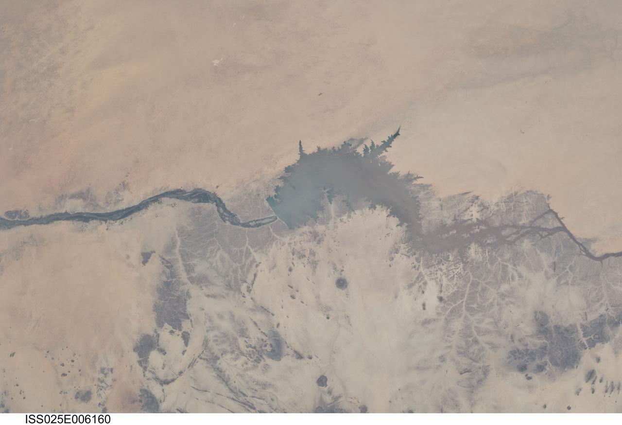
ISS025-E-006160 (5 Oct. 2010) --- Merowe Dam, Nile River and the Republic of the Sudan are featured in this image photographed by an Expedition 25 crew member on the International Space Station. The Merowe Dam is located near the 4th cataract of the Nile River, in the Nubian Desert of the northeastern Republic of the Sudan (also known as Sudan). The dam was built to generate hydroelectric power—electricity intended to further industrial and agricultural development of the country. This photograph illustrates the current extent of the reservoir filling behind the dam; the final spill gate was closed in 2008. The Merowe Dam is located approximately 350 kilometers (215 miles) to the northwest of Sudan’s capital, Khartoum. The nearest settlement downstream of the dam is Karima. Following Sudan’s independence from Egypt and the United Kingdom in 1956, allocation and control of Nile River water was divided between Egypt and Sudan by the Nile Waters Treaty signed in 1959. Today, other countries within the Nile basin—including Ethiopia, Kenya, Rwanda, Tanzania, and Uganda—are seeking more equitable allocation and utilization of the water and recently (2010) signed a new water use pact challenging the 1959 treaty. Beyond the issues of water rights, several local tribes will be displaced by the planned 170 kilometer-long reservoir, and the flooded region contains significant but little-studied archeological sites. The Sudanese government has a resettlement program in place for the tribes. A variety of international institutions have been conducting “salvage” or “rescue” archeological surveys since 1999. Such rescue surveys seek to preserve as much information as possible from sites that will be destroyed or otherwise made inaccessible (in this case by flooding).
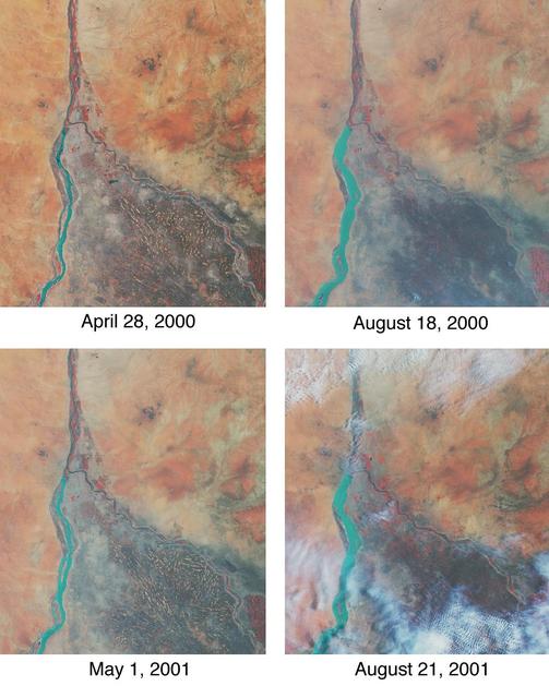
Throughout history, the rising and falling waters of the mighty Nile River have directly impacted the lives of the people who live along its banks. These images of the area around Sudan's capital city of Khartoum capture the river's dynamic nature. Acquired by the Multi-angle Imaging SpectroRadiometer's nadir (vertical-viewing) camera, they display the extent of the Nile waters before and after the onset of the rainy seasons of 2000 (top pair) and 2001 (bottom pair). The images are displayed in "false color," using the camera's near-infrared, green, and blue bands. With this particular spectral combination, water appears in shades of blue and turquoise, and highly vegetated areas show up as bright red. Originating in Uganda and Ethiopia, respectively, the waters of the White Nile (western branch) and Blue Nile (eastern branch) converge at Khartoum (about half-way between image center and the left-hand side), and continue to flow northward as the Great Nile. Although the most obvious feature in these images is the increased width of the White Nile between spring and summer, careful inspection shows that the Great Nile is at its widest in August 2001 (note in particular the area between the clouds near the top of this panel). Heavy rains in the Blue Nile catchment area of the Ethiopian highlands led to a rapid overflow of the river's floodwaters into the main stream of the Great Nile, leading to extensive flooding, the worst effects of which occurred north of Khartoum. According to the Food and Agriculture Organization of the United Nations, tens of thousands of people have fled their homes, and the number of people in need of urgent food assistance in Sudan, estimated at three million earlier in the year, was likely to increase with the onset of these floods. South of the confluence of the White Nile and the Blue Nile, the area of a cross-hatched appearance is the irrigated plain of El Gezira. The Gezira irrigation scheme uses water from the Makwar Dam (now called the Sennar Dam), located across the Blue Nile south of Khartoum. Among the main agricultural products of this region are cotton, millet, peanuts and fodder crops. Overall prospects for Sudan's 2001 grain crop were already poor prior to the flooding due to a late start of the rainy season in parts of the country. Following two consecutive years of serious drought, precipitation arrived too late to save the grain harvest that normally begins in late August. Lower harvests for the past two years coupled with depletion of stocks have led to a rise in cereal prices, reducing access to food for the Sudan's poorer citizens, already suffering from the effects of Africa's longest running civil war. Each of these images represents an area of about 130 kilometers x 150 kilometers. The data were obtained during Terra orbits 1922, 3553, 7281, and 8912. http://photojournal.jpl.nasa.gov/catalog/PIA03420