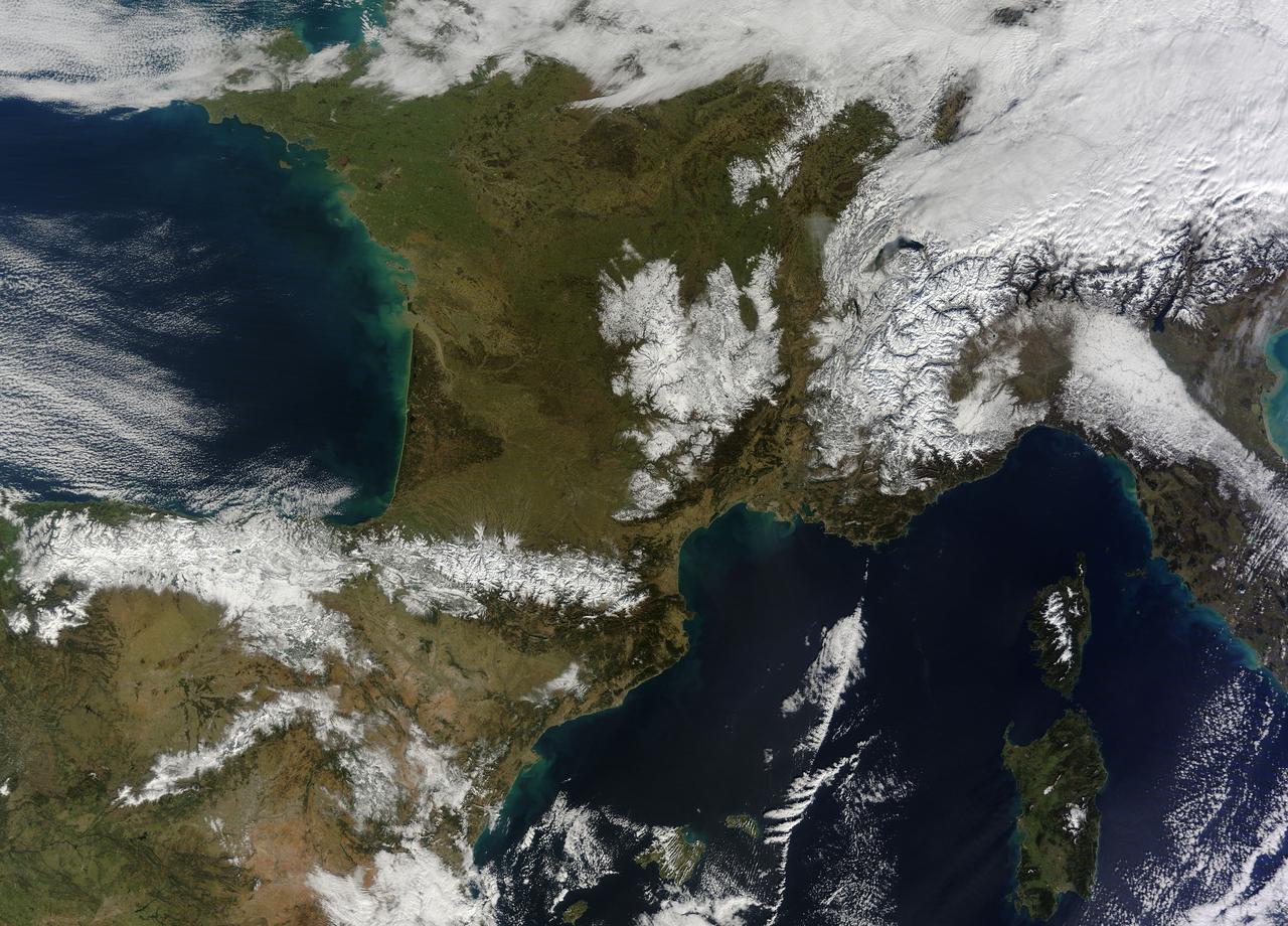
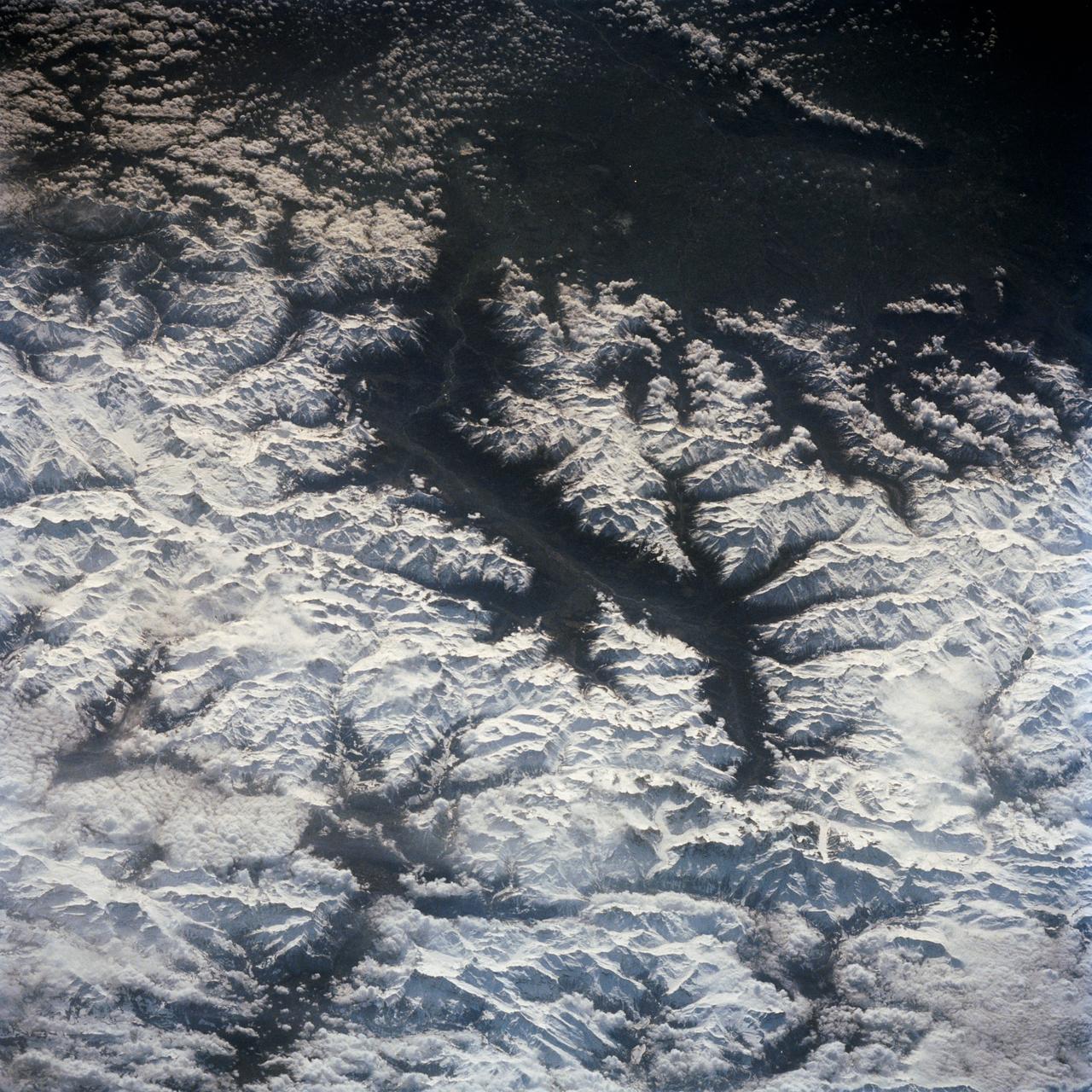
In February 2015, New England was not alone in dealing with the wrath of Old Man Winter. Thick snow blanketed mountain ranges in southwestern Europe after a winter storm pushed through the region in early February. The Moderate Resolution Imaging Spectroradiometer (MODIS) on NASA’s Terra satellite captured this true-color image of the snow-covered peaks of the Cantabrian Mountains, the Pyrenees, the Alps, and Massif Central on February 9, 2015. Credit: NASA/GSFC/Jeff Schmaltz/MODIS Land Rapid Response Team <b><a href="http://www.nasa.gov/audience/formedia/features/MP_Photo_Guidelines.html" rel="nofollow">NASA image use policy.</a></b> <b><a href="http://www.nasa.gov/centers/goddard/home/index.html" rel="nofollow">NASA Goddard Space Flight Center</a></b> enables NASA’s mission through four scientific endeavors: Earth Science, Heliophysics, Solar System Exploration, and Astrophysics. Goddard plays a leading role in NASA’s accomplishments by contributing compelling scientific knowledge to advance the Agency’s mission. <b>Follow us on <a href="http://twitter.com/NASAGoddardPix" rel="nofollow">Twitter</a></b> <b>Like us on <a href="http://www.facebook.com/pages/Greenbelt-MD/NASA-Goddard/395013845897?ref=tsd" rel="nofollow">Facebook</a></b> <b>Find us on <a href="http://instagram.com/nasagoddard?vm=grid" rel="nofollow">Instagram</a></b>
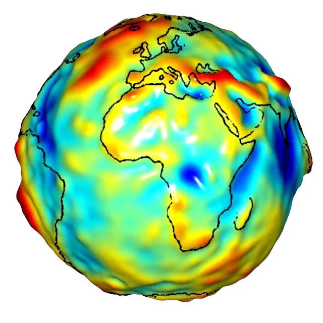
This visualization of a gravity model was created with data from NASA’s Gravity Recovery and Climate Experiment and shows variations in the gravity field across Africa and Europe.
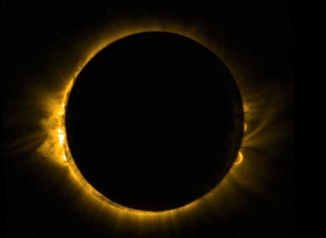
As Europe enjoyed a partial solar eclipse on the morning of Friday 20 March 2015, ESA’s Sun-watching Proba-2 minisatellite had a ringside seat from orbit. Proba-2 used its SWAP imager to capture the Moon passing in front of the Sun in a near-totality. SWAP views the solar disc at extreme ultraviolet wavelengths to capture the turbulent surface of the Sun and its swirling corona. Credit: ESA/Proba-2
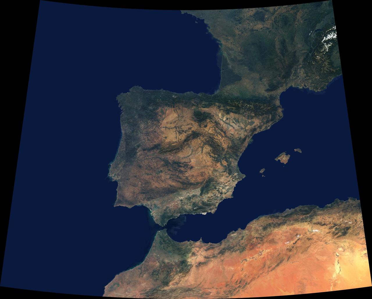
Data from a portion of the imagery acquired by NASA Terra spacecraft during 2000-2002 were combined to create this cloud-free natural-color mosaic of southwestern Europe and northwestern Morocco and Algeria.
This composite image shows the weather situation over Europe at 12:00 UTC on 13 February 2014. The image is composed of infra-red imagery from the geostationary satellites of EUMETSAT and NOAA, overlaid on NASA's Blue Marble land imagery. Copyright: 2014 EUMETSAT, <a href="http://www.flickr.com/photos/eumetsat/12500210655">www.flickr.com/photos/eumetsat/12500210655</a>
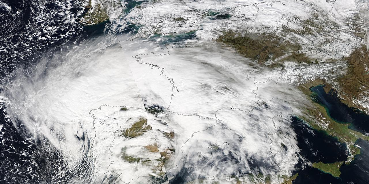
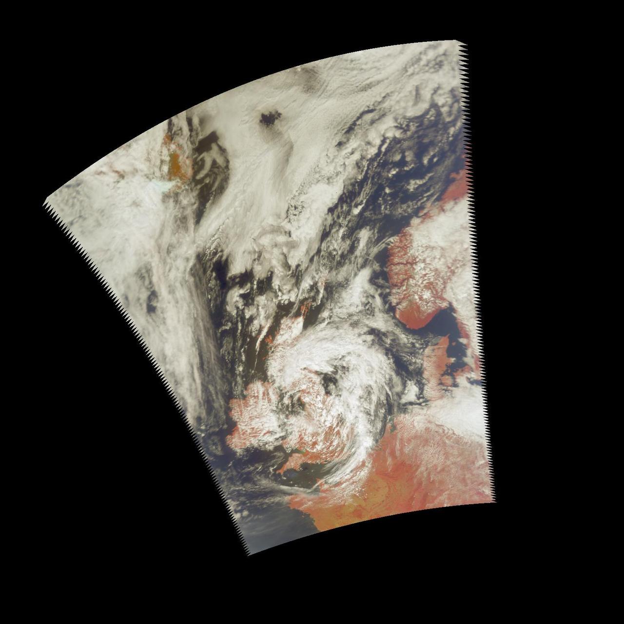
Image acquired February 27, 2010: An extratropical cyclone named Xynthia brought hurricane-force winds and high waves to Western Europe at the end of February 2010, CNN reported. Winds as fast as 200 kilometers (125 miles) per hour reached as far inland as Paris, and at the storm’s peak, hurricane-force winds extended from Portugal to the Netherlands. Hundreds of people had to take refuge from rising waters on their rooftops. By March 1, at least 58 people had died, some of them struck by falling trees. Most of the deaths occurred in France, but the storm also caused casualties in England, Germany, Belgium, Spain, and Portugal. The Moderate Resolution Imaging Spectroradiometer (MODIS) on NASA’s Aqua satellite captured this image of Western Europe, acquired in two separate overpasses on February 27, 2010. MODIS captured the eastern half of the image around 10:50 UTC, and the western half about 12:30 UTC. Forming a giant comma shape, clouds stretch from the Atlantic Ocean to northern Italy. NASA image courtesy MODIS Rapid Response Team at NASA Goddard Space Flight Center. Caption by Michon Scott. Instrument: Aqua - MODIS For more information related to this image go to: <a href="http://earthobservatory.nasa.gov/NaturalHazards/view.php?id=42881" rel="nofollow">earthobservatory.nasa.gov/NaturalHazards/view.php?id=42881</a>

During the last weeks of March 2003, unusually high and widespread aerosol pollution was detected over Europe by several satellite-borne instruments aboard NASA Terra satellite.

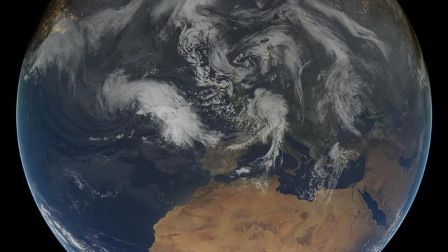
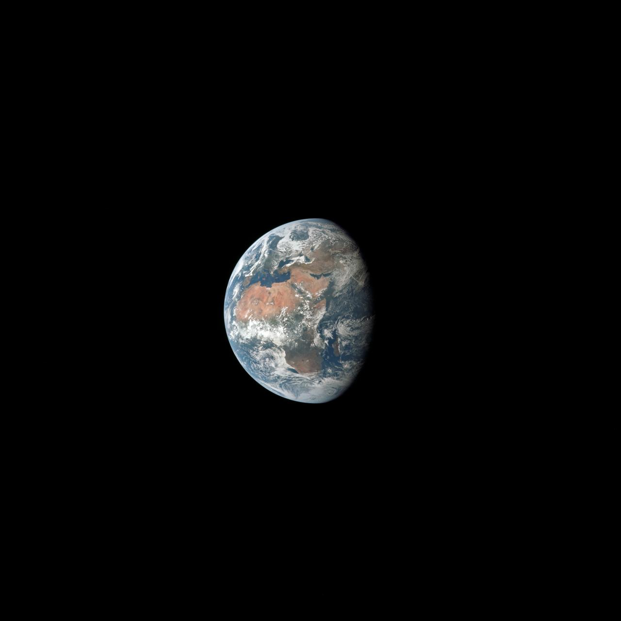
Africa is front and center in this image of Earth taken by a NASA camera on the Deep Space Climate Observatory (DSCOVR) satellite. The image, taken July 6 from a vantage point one million miles from Earth, was one of the first taken by NASA’s Earth Polychromatic Imaging Camera (EPIC). Central Europe is toward the top of the image with the Sahara Desert to the south, showing the Nile River flowing to the Mediterranean Sea through Egypt. The photographic-quality color image was generated by combining three separate images of the entire Earth taken a few minutes apart. The camera takes a series of 10 images using different narrowband filters -- from ultraviolet to near infrared -- to produce a variety of science products. The red, green and blue channel images are used in these Earth images. The DSCOVR mission is a partnership between NASA, the National Oceanic and Atmospheric Administration (NOAA) and the U.S. Air Force, with the primary objective to maintain the nation’s real-time solar wind monitoring capabilities, which are critical to the accuracy and lead time of space weather alerts and forecasts from NOAA. DSCOVR was launched in February to its planned orbit at the first Lagrange point or L1, about one million miles from Earth toward the sun. It’s from that unique vantage point that the EPIC instrument is acquiring images of the entire sunlit face of Earth. Data from EPIC will be used to measure ozone and aerosol levels in Earth’s atmosphere, cloud height, vegetation properties and a variety of other features. Image Credit: NASA <b><a href="http://www.nasa.gov/audience/formedia/features/MP_Photo_Guidelines.html" rel="nofollow">NASA image use policy.</a></b> <b><a href="http://www.nasa.gov/centers/goddard/home/index.html" rel="nofollow">NASA Goddard Space Flight Center</a></b> enables NASA’s mission through four scientific endeavors: Earth Science, Heliophysics, Solar System Exploration, and Astrophysics. Goddard plays a leading role in NASA’s accomplishments by contributing compelling scientific knowledge to advance the Agency’s mission. <b>Follow us on <a href="http://twitter.com/NASAGoddardPix" rel="nofollow">Twitter</a></b> <b>Like us on <a href="http://www.facebook.com/pages/Greenbelt-MD/NASA-Goddard/395013845897?ref=tsd" rel="nofollow">Facebook</a></b> <b>Find us on <a href="http://instagrid.me/nasagoddard/?vm=grid" rel="nofollow">Instagram</a></b>
AIRS Retrieved Temperature Isotherms over Southern Europe viewed from the west, September 8, 2002. The isotherms in this map made from AIRS onboard NASA Aqua satellite data show regions of the same temperature in the atmosphere. http://photojournal.jpl.nasa.gov/catalog/PIA00513
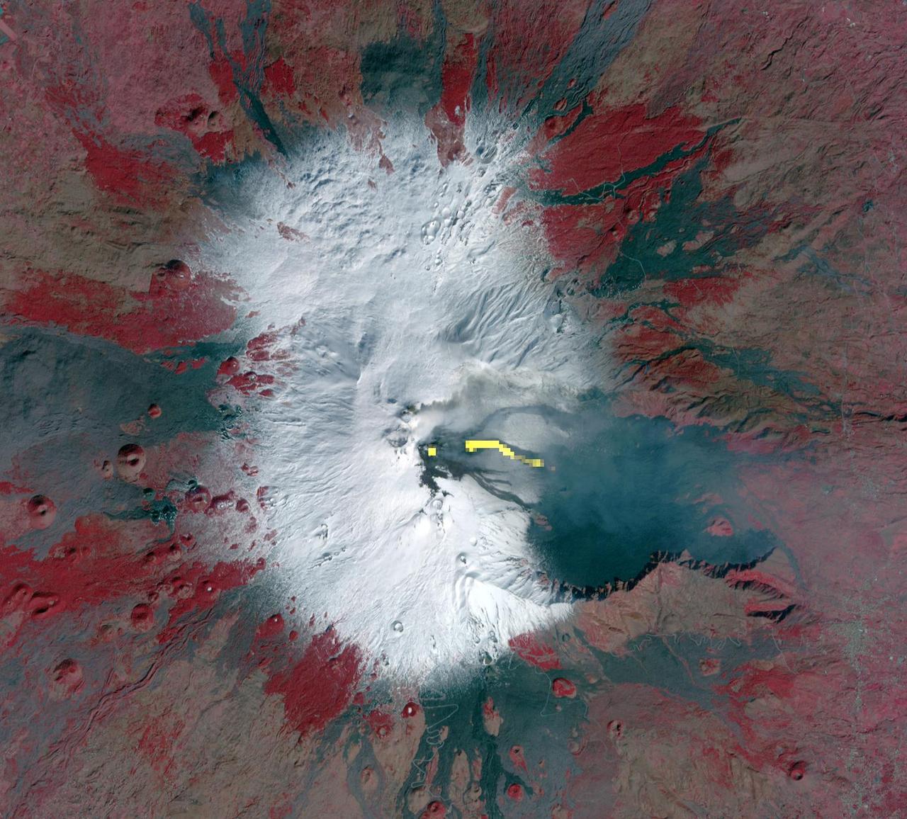
This image acquired by NASA Terra spacecraft is of Mt. Etna, Europe most active volcano, as it continued its latest eruptive activity with a new lava flow from the recently formed southeast crater.

NASA image acquired April 18 - October 23, 2012 This new image of Europe, Africa, and the Middle East at night is a composite assembled from data acquired by the Suomi NPP satellite in April and October 2012. The new data was mapped over existing Blue Marble imagery of Earth to provide a realistic view of the planet. The nighttime view was made possible by the new satellite’s “day-night band” of the Visible Infrared Imaging Radiometer Suite. VIIRS detects light in a range of wavelengths from green to near-infrared and uses filtering techniques to observe dim signals such as gas flares, auroras, wildfires, city lights, and reflected moonlight. In this case, auroras, fires, and other stray light have been removed to emphasize the city lights. “Night time imagery provides an intuitively graspable view of our planet,” says William Stefanov, senior remote sensing scientist for the International Space Station program office. “They provide a fairly straightforward means to map urban versus rural areas, and to show where the major population centers are and where they are not.” Named for satellite meteorology pioneer Verner Suomi, NPP flies over any given point on Earth's surface twice each day at roughly 1:30 a.m. and p.m. The polar-orbiting satellite flies 824 kilometers (512 miles) above the surface, sending its data once per orbit to a ground station in Svalbard, Norway, and continuously to local direct broadcast users distributed around the world. The mission is managed by NASA with operational support from NOAA and its Joint Polar Satellite System, which manages the satellite's ground system. NASA Earth Observatory image by Robert Simmon, using Suomi NPP VIIRS data provided courtesy of Chris Elvidge (NOAA National Geophysical Data Center). Suomi NPP is the result of a partnership between NASA, NOAA, and the Department of Defense. Caption by Mike Carlowicz. Instrument: Suomi NPP - VIIRS Credit: <b><a href="http://www.earthobservatory.nasa.gov/" rel="nofollow"> NASA Earth Observatory</a></b> <b>Click here to view all of the <a href="http://earthobservatory.nasa.gov/Features/NightLights/" rel="nofollow"> Earth at Night 2012 images </a></b> <b>Click here to <a href="http://earthobservatory.nasa.gov/NaturalHazards/view.php?id=79793" rel="nofollow"> read more </a> about this image </b> <b><a href="http://www.nasa.gov/audience/formedia/features/MP_Photo_Guidelines.html" rel="nofollow">NASA image use policy.</a></b> <b><a href="http://www.nasa.gov/centers/goddard/home/index.html" rel="nofollow">NASA Goddard Space Flight Center</a></b> enables NASA’s mission through four scientific endeavors: Earth Science, Heliophysics, Solar System Exploration, and Astrophysics. Goddard plays a leading role in NASA’s accomplishments by contributing compelling scientific knowledge to advance the Agency’s mission. <b>Follow us on <a href="http://twitter.com/NASA_GoddardPix" rel="nofollow">Twitter</a></b> <b>Like us on <a href="http://www.facebook.com/pages/Greenbelt-MD/NASA-Goddard/395013845897?ref=tsd" rel="nofollow">Facebook</a></b> <b>Find us on <a href="http://instagram.com/nasagoddard?vm=grid" rel="nofollow">Instagram</a></b>
In this southeast looking view, Mont Blanc, on the French/Italian border, (48.0N, 4.5E) the highest mountain peak in all of Europe, is just below and right of center (below the end of the prominent valley of the Aosta River, in the center of the photo. The rivers flow out of the Alps into Italy toward Turin. Chamonix, the famous resort town and center of Alpine mountain climbing, lies in the valley just below Mont Blanc.
These images, taken over northern Europe on July 20, 2002, depict a few of the different views of Earth and its atmosphere that are produced by the Atmospheric Infrared Sounder experiment system operating on NASA Aqua spacecraft. http://photojournal.jpl.nasa.gov/catalog/PIA00345
iss071e462180 (Aug. 9, 2024) --- Lake Assad in Syria (upper right) and lakes created by hydroelectric dams in Turkiye, all along the Euphrates River, are pictured from the International Space Station as it orbited 263 miles above the Turkish nation that connects Europe with Asia.

iss073e0686732 (Aug. 30, 2025) --- The atmospheric glow blankets southern Europe and the northwestern Mediterranean coast, outlined by city lights. At left, the Po Valley urban corridor in Italy shines with the metropolitan areas of Milan and Turin and their surrounding suburbs. This photograph was taken at approximately 1:39 a.m. local time from the International Space Station as it orbited 261 miles above Earth.
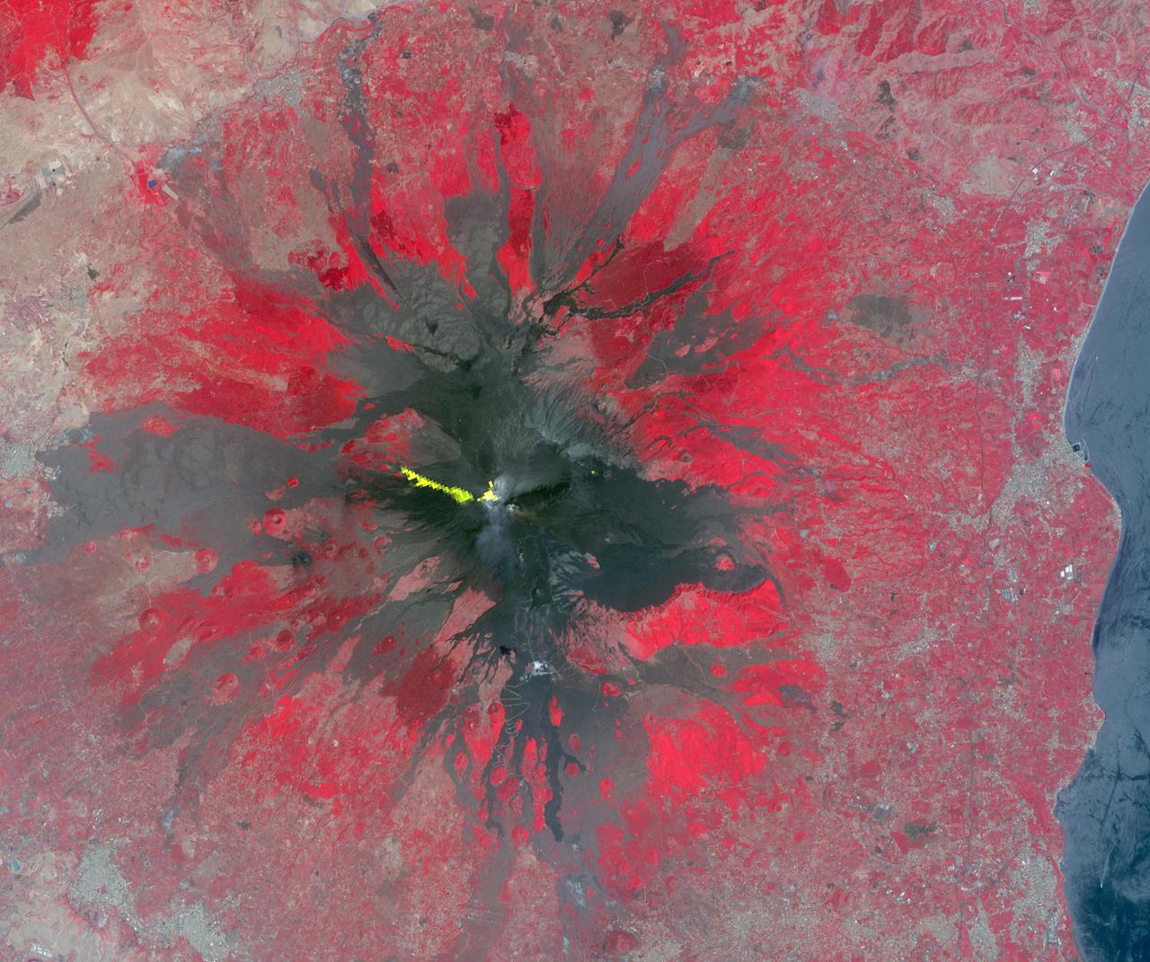
Mt. Etna, Sicily, Italy, is Europe most active volcano. In mid-May 2016, Mt. Etna put on a display of lava fountaining, ash clouds and lava flows. Three of the four summit craters were active. NASA Terra spacecraft acquired this image on May 26, 2016.
iss073e0429432 (Aug. 10, 2025) --- Europe's tallest and most active volcano, Mount Etna located on the Italian island of Sicily in the Mediterranean Sea, is pictured from the International Space Station as it orbited 261 miles above the Tyrrhenian Sea. Credit: Roscosmos
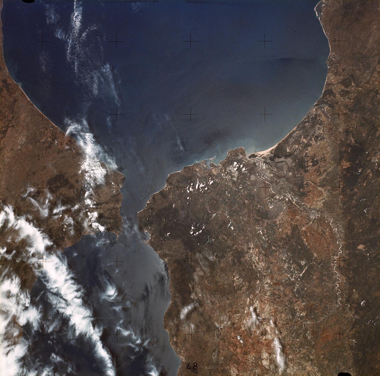
SL2-05-370 (22 June 1973) --- Gateway to the Atlantic, since ancient times the Strait of Gibraltar (36.5N, 4.5W) is also the border between Africa and Europe. In Spain to the north, the dark area near the coast is the delta of the Guadalquivir River and the city of Seville. The small spike of land on the north side of the strait is the actual Rock of Gibraltar. On the African side, a cloud front cutting across from the coast is blowing into Europe from Morocco and Algeria. Photo credit: NASA

Africa is front and center in this image of Earth taken by a NASA camera on the Deep Space Climate Observatory (DSCOVR) satellite. The image, taken July 6 from a vantage point one million miles from Earth, was one of the first taken by NASA’s Earth Polychromatic Imaging Camera (EPIC). Central Europe is toward the top of the image with the Sahara Desert to the south, showing the Nile River flowing to the Mediterranean Sea through Egypt. The photographic-quality color image was generated by combining three separate images of the entire Earth taken a few minutes apart. The camera takes a series of 10 images using different narrowband filters -- from ultraviolet to near infrared -- to produce a variety of science products. The red, green and blue channel images are used in these Earth images. The DSCOVR mission is a partnership between NASA, the National Oceanic and Atmospheric Administration (NOAA) and the U.S. Air Force, with the primary objective to maintain the nation’s real-time solar wind monitoring capabilities, which are critical to the accuracy and lead time of space weather alerts and forecasts from NOAA. DSCOVR was launched in February to its planned orbit at the first Lagrange point or L1, about one million miles from Earth toward the sun. It’s from that unique vantage point that the EPIC instrument is acquiring images of the entire sunlit face of Earth. Data from EPIC will be used to measure ozone and aerosol levels in Earth’s atmosphere, cloud height, vegetation properties and a variety of other features. Image Credit: NASA

iss074e0224384 (Jan. 6, 2026) --- City lights sparkle across a cloudy Europe and the Alps in this photograph from a window on a SpaceX Dragon crew spacecraft as the International Space Station orbited 266 miles above Germany at approximately 2:37 a.m. local time. In the foreground, is another SpaceX Dragon spacecraft. Credit: JAXA/Kimiya Yui

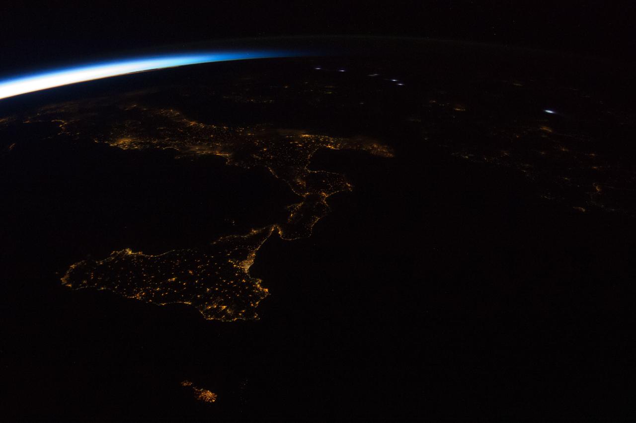
iss073e0698372 (Sept. 13, 2025) --- The boot of Italy, with the island of Sicily at its "toe," glitters in contrast to the surrounding dark blue seas of southern Europe. The International Space Station was orbiting 262 miles above the Mediterranean Sea when this photograph was taken at approximately 1:43 a.m. local time.

iss074e0150285 (Jan. 19, 2026) --- A green and red aurora streams across Earth’s horizon above the city lights of Europe in this photograph, which looks north across Italy toward Germany. The International Space Station was orbiting 262 miles above the Mediterranean Sea at approximately 10:02 p.m. local time when the image was captured. Credit: NASA/Chris Williams
AS11-36-5355 (17 July 1969) --- Most of Africa and portions of Europe and Asia can be seen in this spectacular photograph taken from the Apollo 11 spacecraft during its trans-lunar coast toward the moon. Apollo 11, with astronauts Neil A. Armstrong, commander; Michael Collins, command module pilot; and Edwin E. Aldrin Jr., lunar module pilot, onboard was already 98,000 nautical miles from Earth when this picture was made. While astronauts Armstrong and Aldrin descended in the Lunar Module (LM) "Eagle" to explore the Sea of Tranquility region of the moon, astronaut Collins remained with the Command and Service Modules (CSM) "Columbia" in lunar orbit.

iss073e1198911 (Nov. 28, 2025) --- A red-yellow airglow blankets Earth's horizon as the city lights of southwestern Europe and North Africa sparkle in contrast to the Atlantic Ocean and the Mediterranean Sea that separates the two continents. The International Space Station was orbiting 262 miles above the Atlantic at approximately 7:47 p.m. local time when this photograph was taken.
NASA Terra spacecraft acquired this image of the City of Luxembourg, one of Europe greatest fortified states. With a population of about 90,000, the city is the capital of the Grand Duchy of Luxembourg.
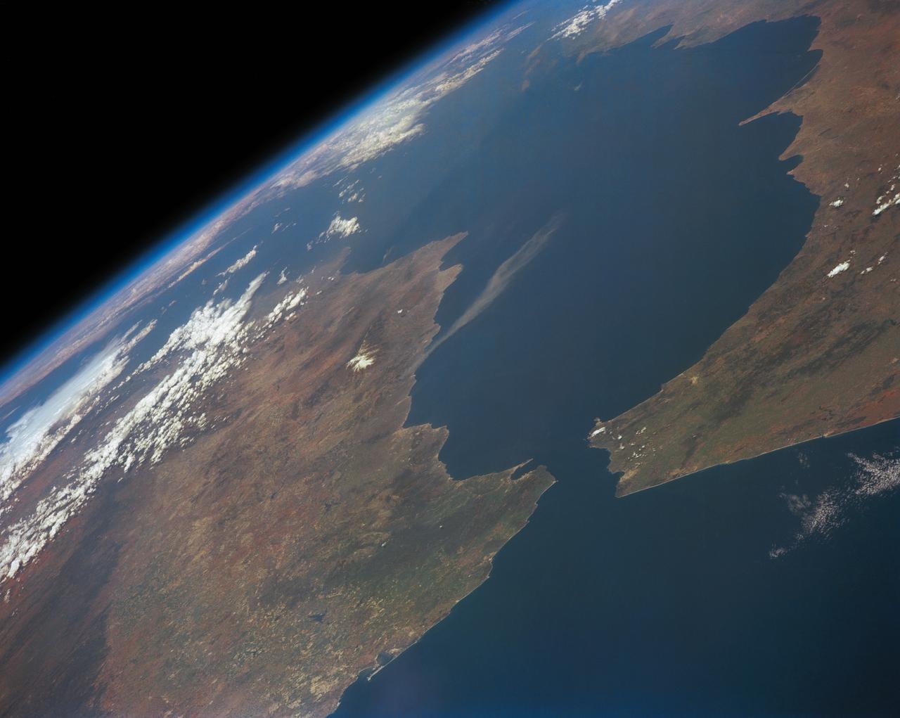
STS039-151-193 (28 April-6 May 1991) --- The Strait of Gibraltar, the only outlet for the Mediterranean Sea, was photographed with a large format handheld camera by the STS-39 crew members. Scientists site evidence in Shuttle photography that the Mediterranean Sea dried up a number of times between 5 million and 20 million years ago. Sea levels, they say, dropped slightly, cutting off the Mediterranean (top right) from the Atlantic Ocean (bottom). In southern Spain, the dark area near the coast is the delta of the Guadalquivir River with the city of Seville. The Sierra Nevada range still has some snow. A small field fire near the Spanish coast has generated a conspicuous smoke plume. The small spike of land on the north side of the Strait is the Rock of Gibraltar, an outpost of the British empire. The larger spike of land on the north coast of Africa marks the border between Morocco (center foreground) and Algeria (right). The sharp line cutting across them Mediterranean (top right) marks the edge of a dust cloud blowing from Africa into Europe. Photo credit: NASA

The Eastern U.S., Europe, and Japan are brightly lit by their cities, while interiors of Africa, Asia, Australia, and South America are dark and lightly populated in this image created in 2000 by NASA Goddard Space Flight Center.
The MISR instrument aboard NASA Terra spacecraft captured this stereo image of Russia Volga River, the largest river system in Europe. 3D glasses are necessary to view this image.
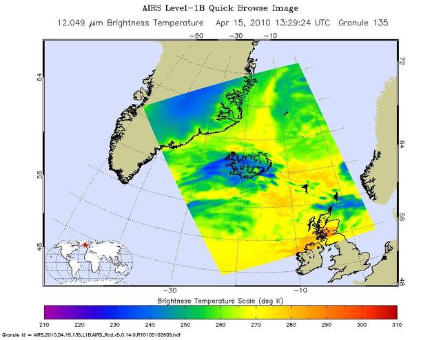
Ash from Iceland Eyjafjallajökull volcano, viewed here in imagery from NASA Terra spacecraft on May 16, 2010, once again disrupted air traffic over Europe with the closure of major airports in the United Kingdom and the Netherlands.
This image acquired by NASA Terra spacecraft is of Mount Etna, on the Italian island of Sicily, Europe most active volcano, where its latest series of eruptions has continued for weeks.
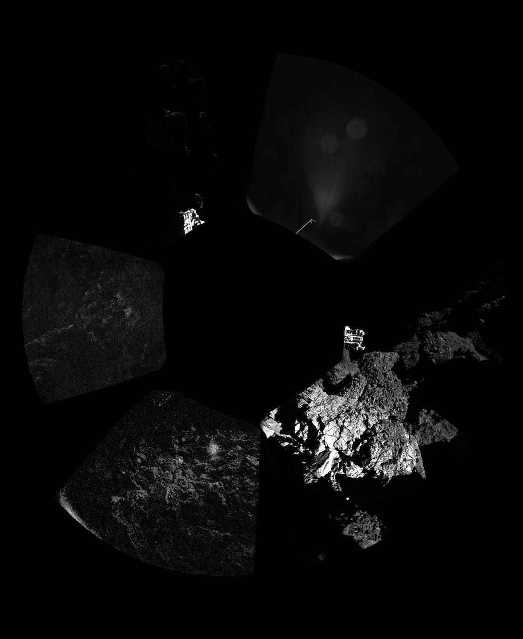
The Philae lander of Europe Rosetta mission has returned the first panoramic image from the surface of a comet. The unprocessed panorama from the lander CIVA-P camera shows a 360-degree view around the point of final touchdown.
This image from NASA Terra spacecraft shows ash plumes from Eyjafjallajökull Volcano, Iceland stretching over the North Atlantic; the volcano erupted on April 14, 2010 bringing closure to major airports in Europe.
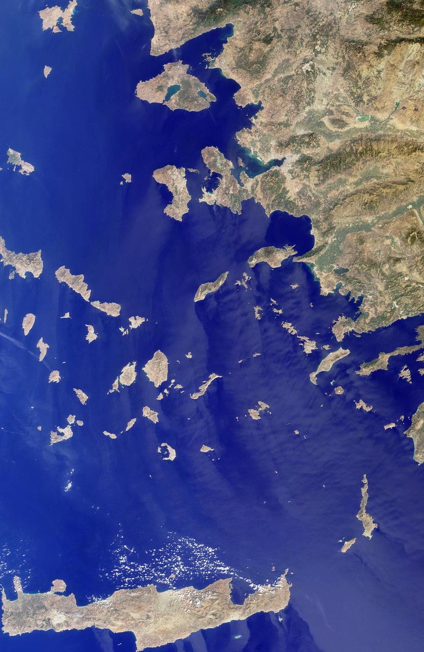
The Greek islands of the Aegean Sea, scattered across 800 kilometers from north to south and between Greece and western Turkey, are uniquely situated at the intersection of Europe, Asia and Africa. This image from NASA Terra satellite was acquired on Se
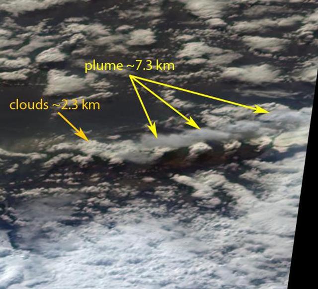
NASA Aqua satellite flew over the volcano on April 15, capturing this image of the ash plume. The image shows the ash cloud being carried over the Shetland Islands and onward to Europe.
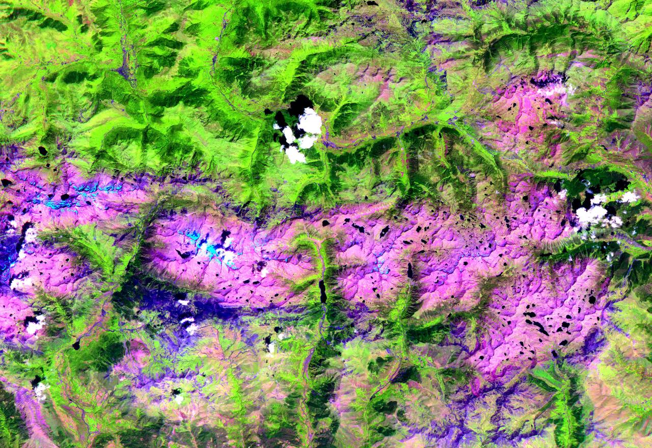
This ASTER image, acquired on August 1, 2000, covers an area of 57 by 29 km and covers part of the central Pyrenees in Spain. The Pyrenees in southwestern Europe extend for about 435 kilometers (about 270 miles) from the Bay of Biscay to the Mediterranean Sea, separating the Iberian Peninsula from the rest of Europe. The Pyrenees form most of the boundary between France and Spain, and encompass the tiny principality of Andorra. Approximately two-thirds of the mountains lie in Spain. The central Pyrenees extend to the Collines du Perche and contain the highest peaks of the system, including Pico de Aneto, the highest at 3,404 meters (11,168 feet). ASTER bands 4, 3 and 2 were displayed in red, green and blue. In this combination, snow is blue, vegetation is green, bare rocks are pink and dark blue, and clouds are white. The image is located at 42.6 degrees north latitude and 0.6 degrees east longitude. http://photojournal.jpl.nasa.gov/catalog/PIA11162

GMT344_23_19_Terry Virts_night wide mexico europe sequence1_cb_131

GMT344_23_19_Terry Virts_night wide mexico europe sequence1_cb_131

GMT344_23_19_Terry Virts_night wide mexico europe sequence1_cb_131

GMT344_23_19_Terry Virts_night wide mexico europe sequence1_cb_131

GMT344_23_19_Terry Virts_night wide mexico europe sequence1_cb_131

GMT344_23_19_Terry Virts_night wide mexico europe sequence1_cb_131
GMT344_23_19_Terry Virts_night wide mexico europe sequence1_cb_131

GMT344_23_19_Terry Virts_night wide mexico europe sequence1_cb_131

GMT344_23_19_Terry Virts_night wide mexico europe sequence1_cb_131

GMT344_23_19_Terry Virts_night wide mexico europe sequence1_cb_131
GMT344_23_19_Terry Virts_night wide mexico europe sequence1_cb_131

GMT344_23_19_Terry Virts_night wide mexico europe sequence1_cb_131
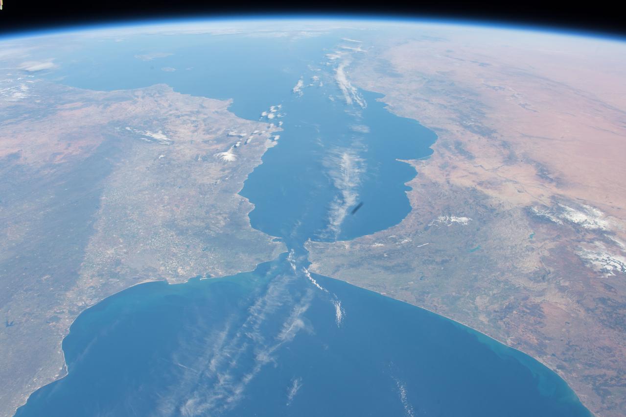
ISS047e001308 (03/02/2016) --- Europe meets Africa in this Earth Observation image captured by NASA astronaut Tim Peake. He tweeted this message out with the photo " Strait of Gibraltar - 9 miles separating #Europe and #Africa . @Space_Station #Explore ".
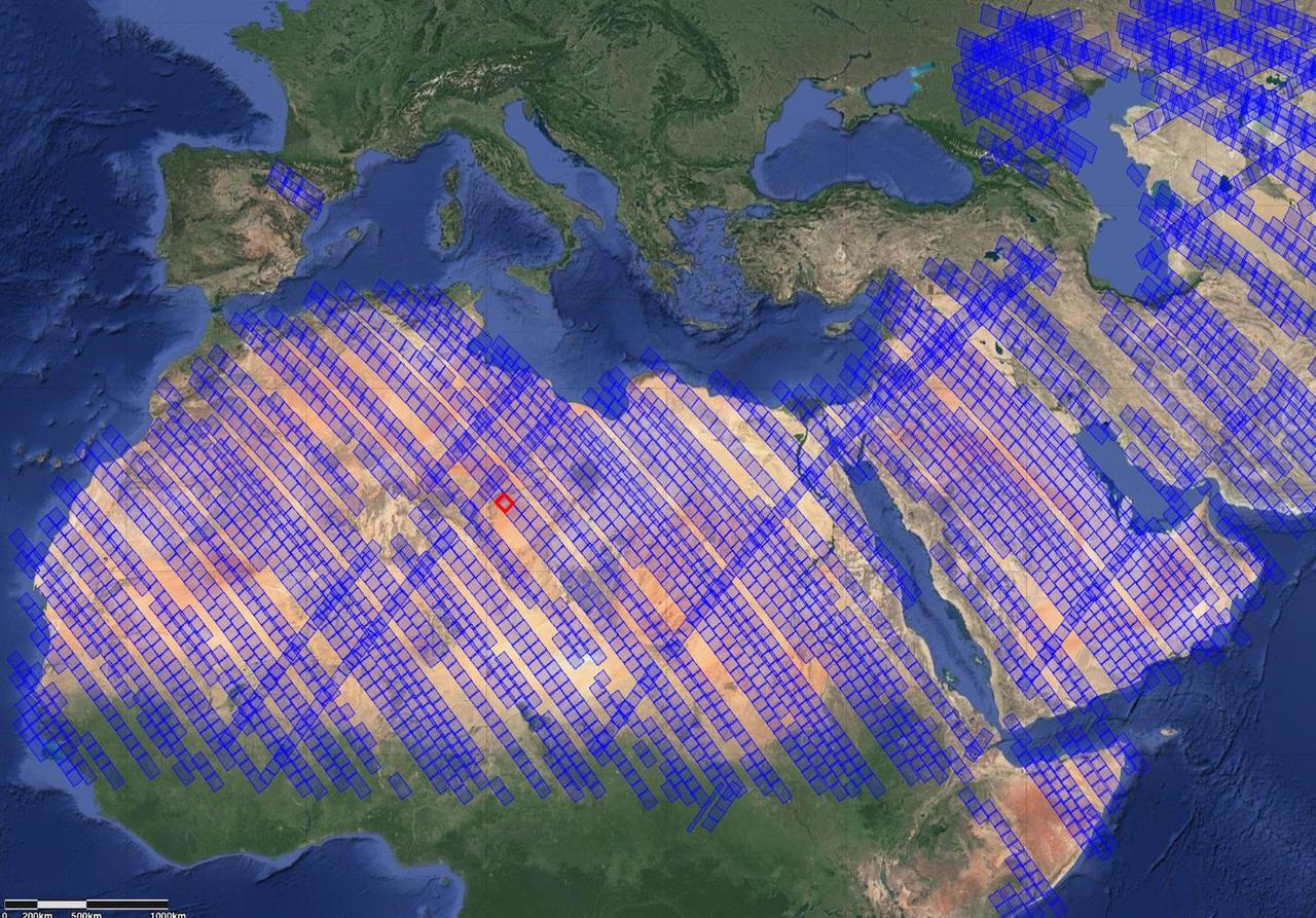
This image shows locations in parts of North Africa, Europe, the Middle East, and Central Asia observed by NASA's Earth Surface Mineral Dust Source Investigation (EMIT). Each blue box is a "scene" the instrument, which is aboard the International Space Station, has captured. The red box indicates where the instrument recently gathered data on three minerals in a location in southwest Libya, in the Sahara Desert. Installed on the space station in July 2022, EMIT orbits Earth about once every 90 minutes to map the world's mineral-dust sources, gathering information about surface composition as the instrument completes about 16 orbits per day. Over the course of its 12-month mission, EMIT will collect measurements of 10 important surface minerals – kaolinite, hematite, goethite, illite, vermiculite, calcite, dolomite, montmorillonite, chlorite, and gypsum – in arid regions between 50-degree south and north latitudes in Africa, Asia, North and South America, and Australia. The data EMIT collects will help scientists better understand the role of airborne dust particles in heating and cooling Earth's atmosphere on global and regional scales. https://photojournal.jpl.nasa.gov/catalog/PIA25429
If you live in Europe and buy roses, the chance is good that they were grown in Kenya -- specifically, in one of the colossal greenhouses that blot out the once wild shores of Lake Naivasha, 90km north-west of Nairobi. Image from NASA Terra satellite.
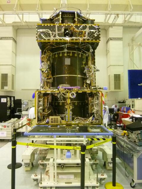
This June 2014 image from the clean room at Thales Alenia Space, in Cannes, France, shows ongoing assembly of the European Space Agency ExoMars Trace Gas Orbiter, including the first of the orbiter two Electra UHF relay radios provided by NASA.
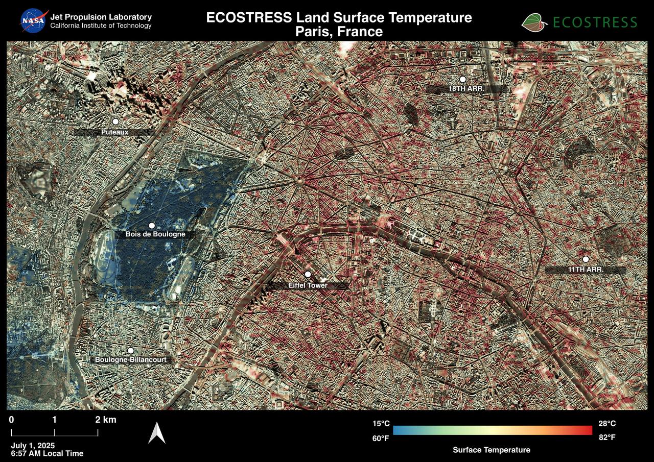
Paris was one of many European cities hit by a record-breaking heat wave at the end of June and early July 2025. NASA's Ecosystem Spaceborne Thermal Radiometer Experiment on Space Station (ECOSTRESS) instrument recorded surface temperatures of 82 degrees Fahrenheit (23 degrees Celsius) at 6:57 a.m. local time on July 1. Extreme daytime air temperatures – of over 100 degrees F (38 degrees C) – prompted officials to close the summit of the Eiffel Tower on July 1 and 2. In this visualization of ECOSTRESS data, dark red indicates higher temperatures while green and blue are cooler. The city is peppered with areas of several blocks where surface temperatures reached more than 80 F (27 C), including around the Eiffel Tower, before 7 a.m. The ECOSTRESS instrument measures thermal infrared emissions from Earth's surface. This enables researchers to monitor plant health, the progress of wildfires, land surface temperatures, and the burn risk to people from hot surfaces such as asphalt. Land surface temperatures are hotter than air temperatures during the day. Air temperatures, which are measured out of direct sunlight, are usually what meteorologists report in a weather forecast. https://photojournal.jpl.nasa.gov/catalog/PIA26190
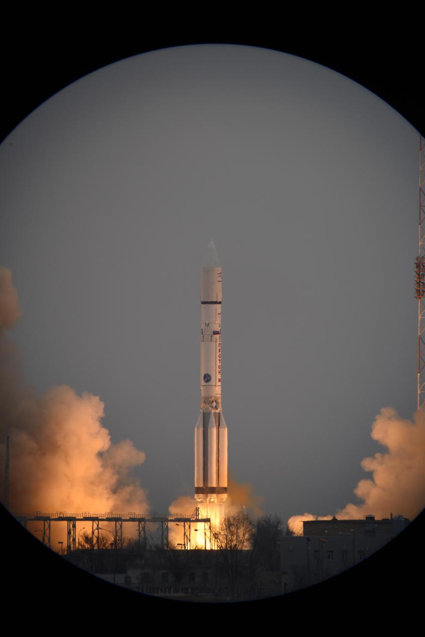
The European Space Agency ExoMars 2016 mission, combining the Trace Gas Orbiter and Schiaparelli landing demonstrator, launches on a Proton launch vehicle from the Baikonur Cosmodrome in Kazakhstan.
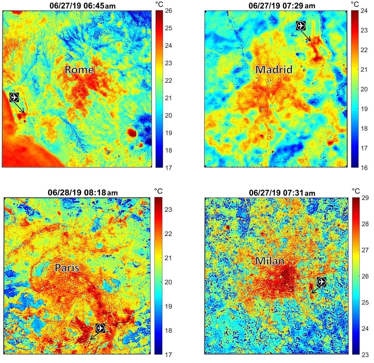
These maps of four European cities show ECOSTRESS surface temperature images acquired in the early mornings of June 27 and 28, 2019, during a heatwave. The images have been sharpened to delineate key features such as airports. Airports and city centers are hotter than surrounding regions because they have more surfaces that retain heat (asphalt, concrete, etc.). ECOSTRESS launched on June 29, 2018, as part of a SpaceX commercial resupply mission to the International Space Station. Its primary mission is to detect plant health by monitoring Earth's surface temperature. However, surface temperature data are also useful in detecting other heat-related phenomena — like heat waves, volcanoes and fires. https://photojournal.jpl.nasa.gov/catalog/PIA23148
iss074e0425752 (March 29, 2026) --- The Strait of Gibraltar separates the European nation of Spain (left) from the African nation of Morocco (right) and connects the Atlantic Ocean to the Mediterranean Sea. The International Space Station was orbiting 266 miles above Spain at the time of this photograph. Credit: NASA

iss065e045974 (May 13, 2021) --- The night lights of Italy are prominent as the International Space Station soared 262 miles above southern Europe during an orbital twilight.

Earth Observation taken during a day pass by the Expedition 40 crew aboard the International Space Station (ISS). Folder lists this as: Central Europe.
Earth Observation taken during a day pass by the Expedition 40 crew aboard the International Space Station (ISS). File lists this as: Brazil and Europe (day).
Earth Observation taken during a day pass by the Expedition 40 crew aboard the International Space Station (ISS). Folder lists this as: Europe and Mediterranean.

Earth Observation taken during a day pass by the Expedition 40 crew aboard the International Space Station (ISS). Folder lists this as: Central Europe.

ISS043e059141 (03/26/2015) --- Members of Expedition 43 on the International Space Station captured this contrasting image of Earth sunrise, aurora and sparling cities in northern Europe.
Earth Observation taken during a day pass by the Expedition 40 crew aboard the International Space Station (ISS). File lists this as: Brazil and Europe (day).

iss066e096808 (Dec. 24, 2021) --- The SpaceX Cargo Dragon vehicle is pictured docked to the International Space Station while orbiting 265 miles above Europe.

iss062e116294 (March 21, 2020) --- Moscow, Russia is pictured from the International Space Station as it orbited 263 miles above eastern Europe.

iss067e302248 (Aug. 31, 2022) --- This night time photograph from the International Space Station as it orbited 261 miles above looks across the Mediterranean Sea from north Africa to southern Europe. The city lights of Algiers, Algeria, to Tunis, Tunisia, highlight Africa's northern coast from the bottom center toward upper right. From far left, the city lights of city-state Monaco to Naples, Italy, define the shores of southern Europe. The French island of Corsica and the Italian island of Sardinia are also pictured.
iss057e051220 (Oct. 13, 2018) --- The International Space Station was orbiting 256 miles above central Europe when this photograph was taken of the Swiss Alps mountain range and the Mediterranean coasts of Italy and France.
iss064e030134 (Feb. 8, 2021) --- An icy northern Europe, looking across Estonia, Russia and Finland, is pictured from the International Space Station as it orbited 265 miles above Ukraine. Credit: Roscosmos
Earth observation taken during a day pass by the Expedition 40 crew aboard the International Space Station (ISS). Folder lists this as: Phenomenon over Northern Russia - 4 (plus Europe pass). Distant and hazy Moon is visible.
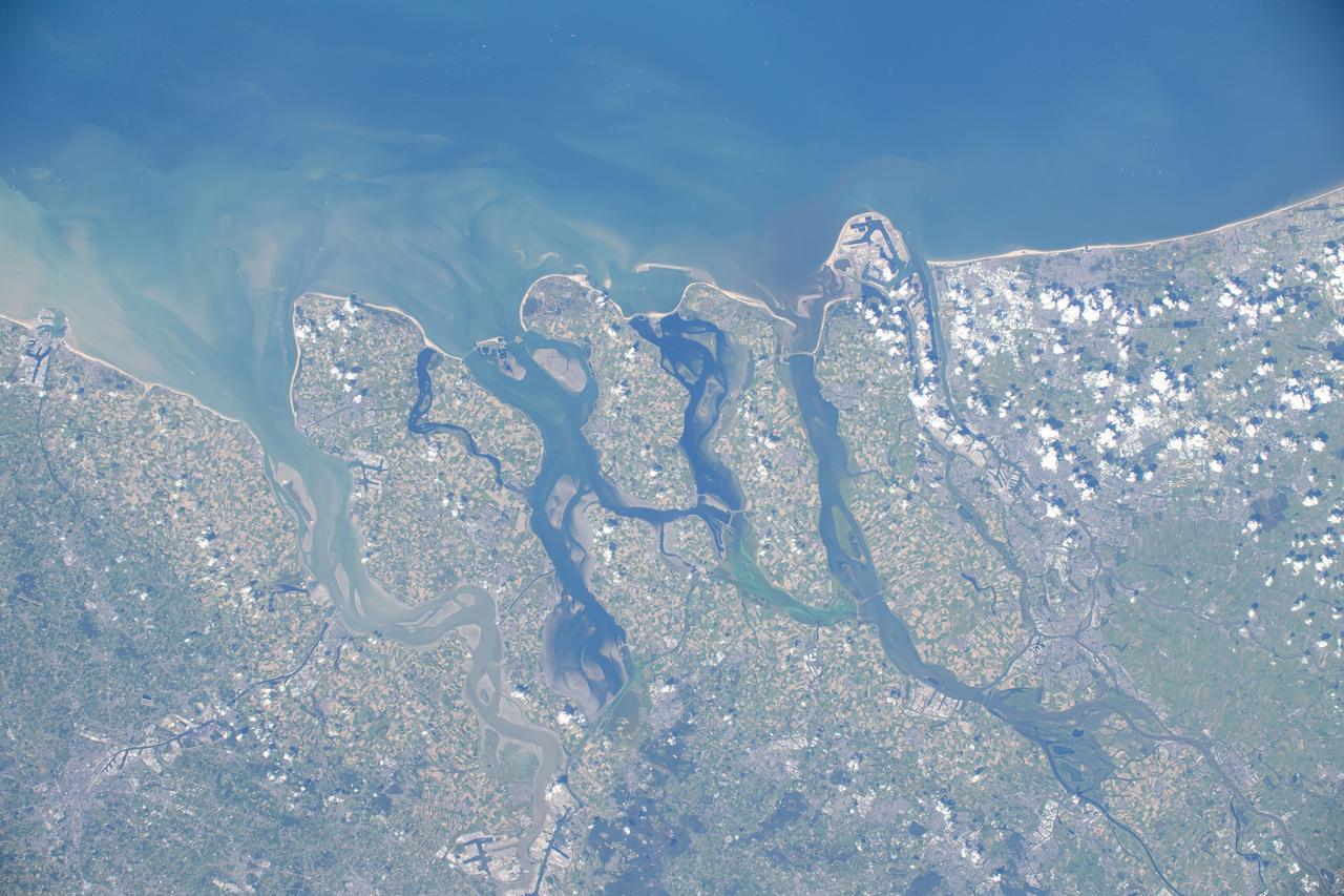
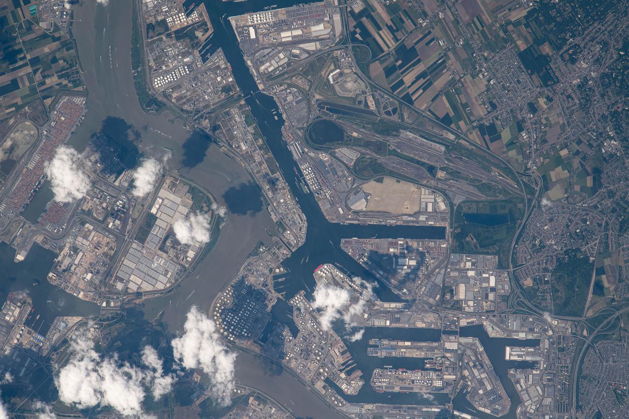
iss071e488058 (Aug. 11, 2024) --- The Hague and Rotterdam, cities next to the Rhine–Meuse–Scheldt river delta in Netherlands on the coast of the North Sea, are pictured from the International Space Station as it orbited 263 miles above Northern Europe.
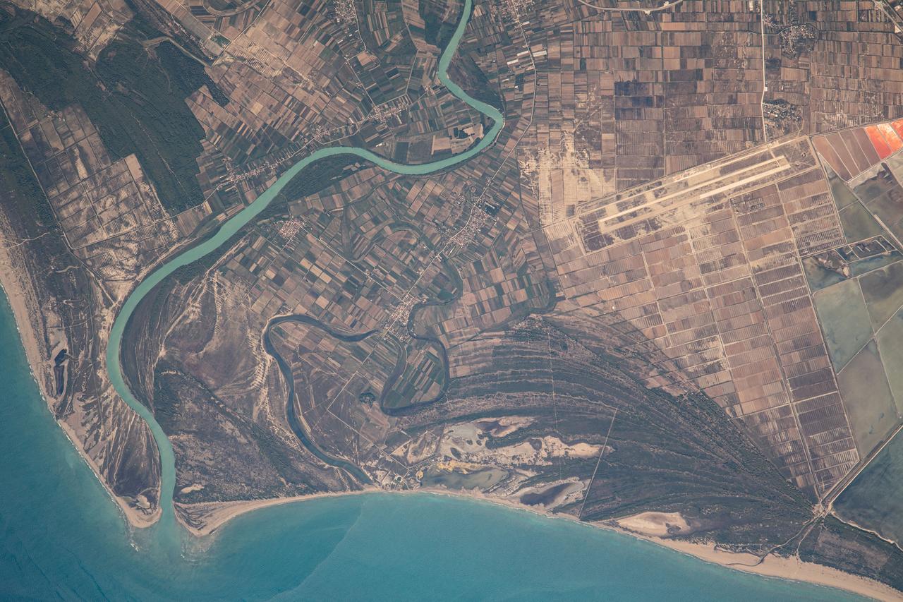
iss069e060397 (Aug. 15, 2023) --- The Aoos River in Albania leads to the Mediterranean Sea in this photograph from the International Space Station as it orbited 264 miles above southern Europe.

International Cooperation Phase III: A Space Shuttle docked to the International Space Station (ISS) in this computer generated representation of the ISS in its completed and fully operational state with elements from the U.S., Europe, Canada, Japan, and Russia.

iss073e0988954 (Oct. 30, 2025) --- An orbital sunrise illuminates Earth's atmosphere and cloud tops in this photograph captured from the International Space Station as it orbited 264 miles above the Czech Republic in Eastern Europe.

iss071e009150 (April 16, 2024) --- Turin, Italy, and its suburbs (at left) lie at the southwestern foot of the Alps in this photograph from the International Space Station as it orbited 260 miles above Europe.
Earth observation taken during a night pass by the Expedition 40 crew aboard the International Space Station (ISS). Folder lists this as: TL Europe Night w dark field.

iss067e218916 (July 31, 2022) --- Instrumentation lights reflect off a window on the International Space Station as it orbited 260 miles above eastern Europe in this night time photograph.
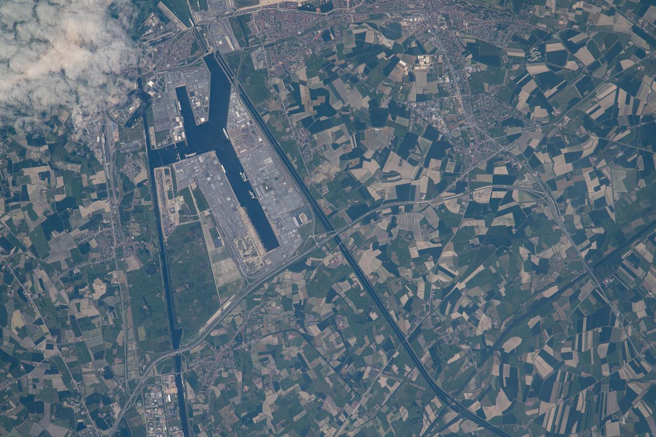
iss065e096048 (June 10, 2021) --- Zeebrugge, a Belgian port and seaside resort on the North Sea coast, is pictured from the International Space Station as it orbited 263 miles above northern Europe.
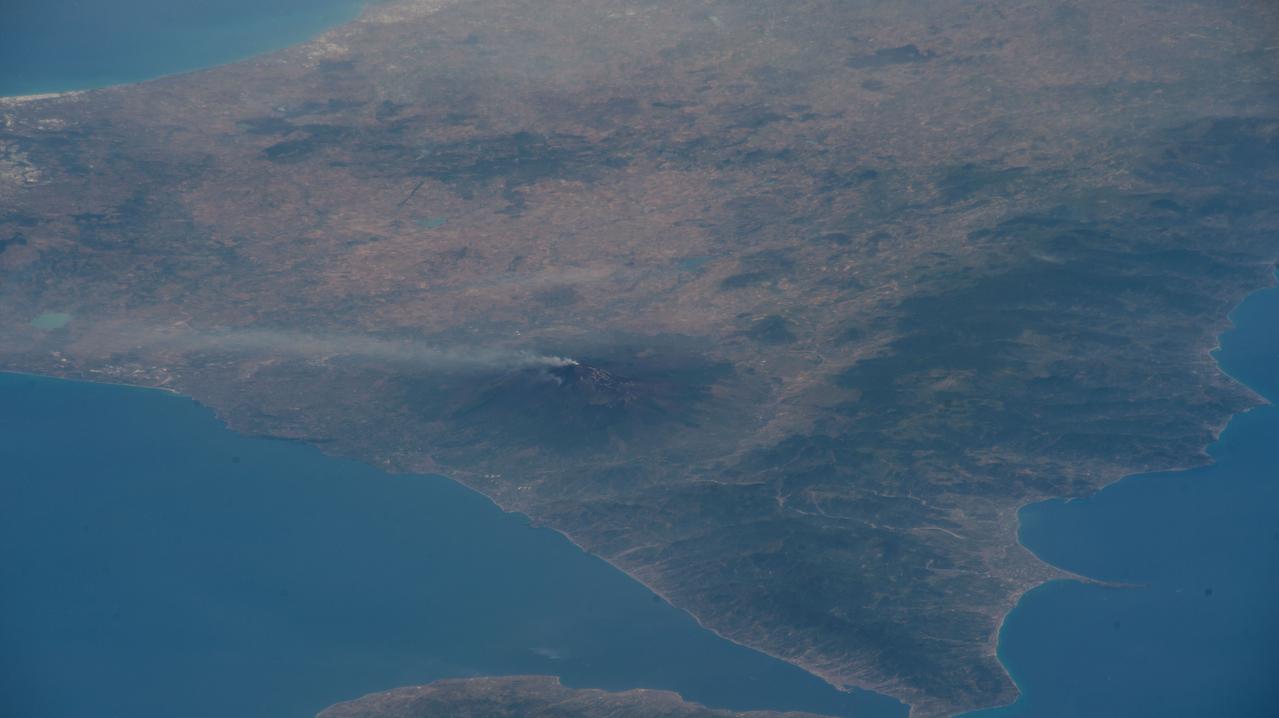
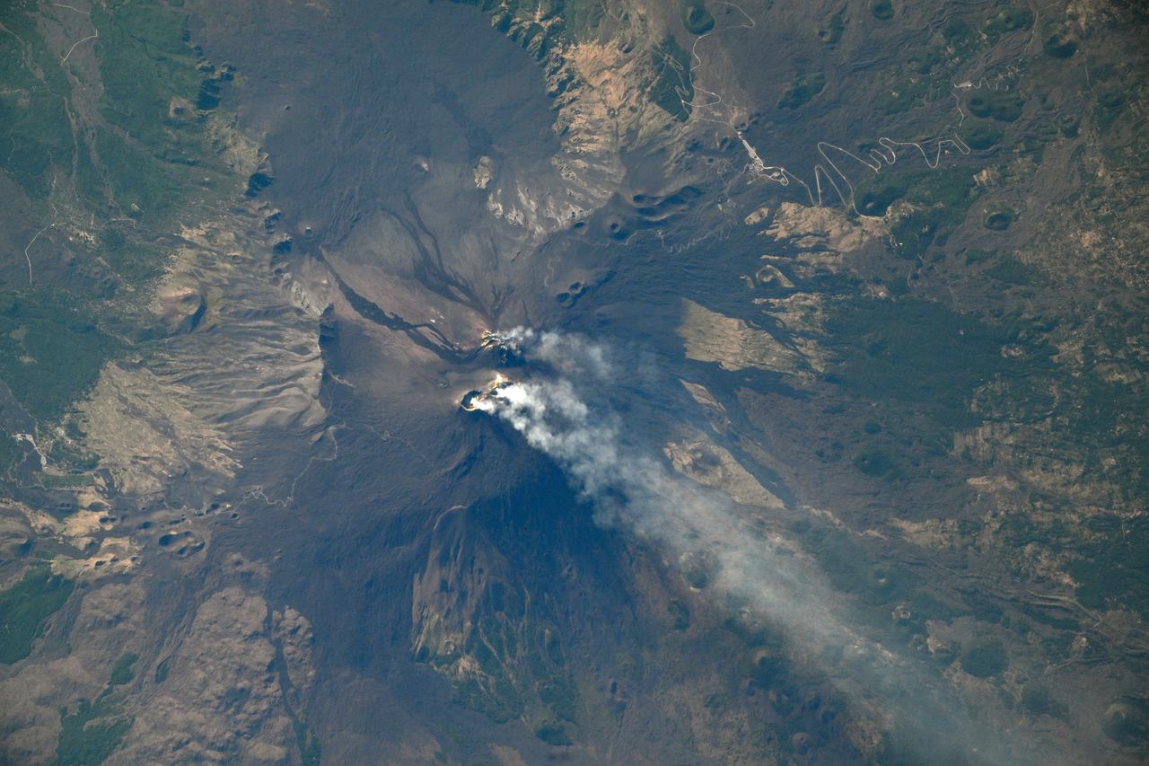
iss067e107088 (June 2, 2022) --- Mount Etna, Europe's tallest active volcano on the coast of Italy's island of Sicily, is pictured billowing with activity as the International Space Station orbited 263 miles above Bulgaria.
Earth observation taken during a day pass by the Expedition 40 crew aboard the International Space Station (ISS). Folder lists this as: Phenomenon over Northern Russia - 4 (plus Europe pass)

iss062e103874 (March 20, 2020) --- The city lights at the intersection of Europe and Asia sparkle underneath an atmospheric glow and a starry night sky as the International Space Station orbited 262 miles above into an orbital sunset.
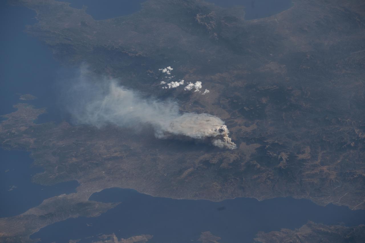
iss073e0421317 (July 22, 2025) --- Wildfires breakout near the Greek village of Feneos south of the Gulf of Corinth in this photograph from the International Space Station as it orbited 261 miles above Southern Europe.

Earth observation taken by the Expedition 39 crew aboard the ISS. A portion of the SpaceX Dragon Commercial Resupply Services-3 (CRS-3) spacecraft is in view. Image was released by astronaut on Twitter and downlinked in folder: Europe.

iss065e029349 (May 9, 2021) --- An orbital twilight fades over the city lights of Europe as the International Space Station soared 263 miles above southern France. At upper right, is the docked SpaceX Crew Dragon Endeavour.
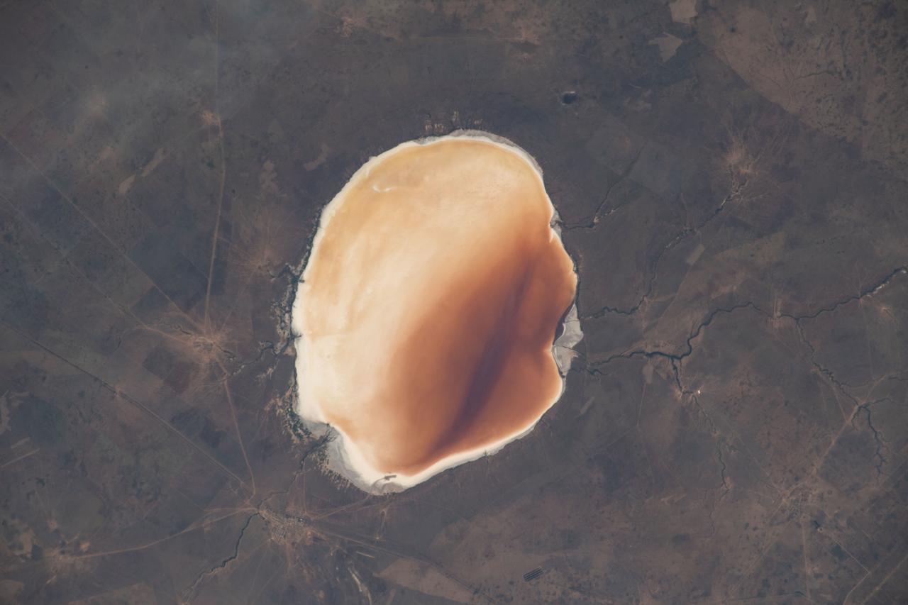
iss059e098991 (June 9, 2019) --- The highly saline Lake Elton in Russia, near the border with Kazakhstan, is the largest mineral lake in Europe. It was photographed from an altitude of 258 miles above the Earth's surface.

jsc2025e000004 (2024) --- View of ESA astronaut Alexander Gerst activating the Electromagnetic Levitator (EML), a microgravity furnace for metals, inside Europe's Columbus module of the International Space Station during his 2014 Blue Dot mission.
STS102-311-013 (8 March 2001) --- The external tank falls toward Earth's atmosphere during the completion of the launch phase of the STS-102 mission. Western Europe is in the background.

iss053e021852 (Sept. 15, 2017) --- This night time view of southern Europe prominently features the “boot” of Italy, the home of current Expedition 53 crew member Paolo Nespoli of the European Space Agency.

iss066e118171 (Jan. 17, 2022) --- A faint aurora and the Earth's atmospheric glow crown this night time photograph of Ireland, Great Britain, and a portion of Northern Europe, as the International Space Station orbited 262 miles above the Atlantic Ocean.
iss055e012690 (April 6, 2018) --- This Earth view taken by an Expedition 55 crew member aboard the International Space Station looks over southeastern Europe, across Italy and into the Mediterranean Sea toward France and Spain.

iss041e107733 (11/4/2014) --- ESA astronaut Alexander Gerst activates the Electromagnetic Levitator (EML), a microgravity furnace for metals, inside Europe's Columbus module of the International Space Station during his 2014 Blue Dot mission.

Earth observation taken during a day pass by the Expedition 40 crew aboard the International Space Station (ISS). Folder lists this as: Phenomenon over Northern Russia - 4 (plus Europe pass)
iss072e574770 (Jan. 29, 2025) --- The Bosphorus Strait splits the city of Istanbul, Türkiye, and connects the Black Sea with the Sea of Marmara in this photograph from the International Space Station as it orbited 260 miles above where Europe connects to Asia.

iss059e061476 (May 13, 2019) --- This oblique nighttime view of Western Europe and the well-lit coasts (from left) of Spain, France and Italy was taken from the International Space Station as it orbited 256 miles above the Mediterranean Sea.
iss065e096050 (June 10, 2021) --- Antwerp, a Belgian port city in the River Scheldt, is pictured from the International Space Station as it orbited 263 miles above northern Europe.
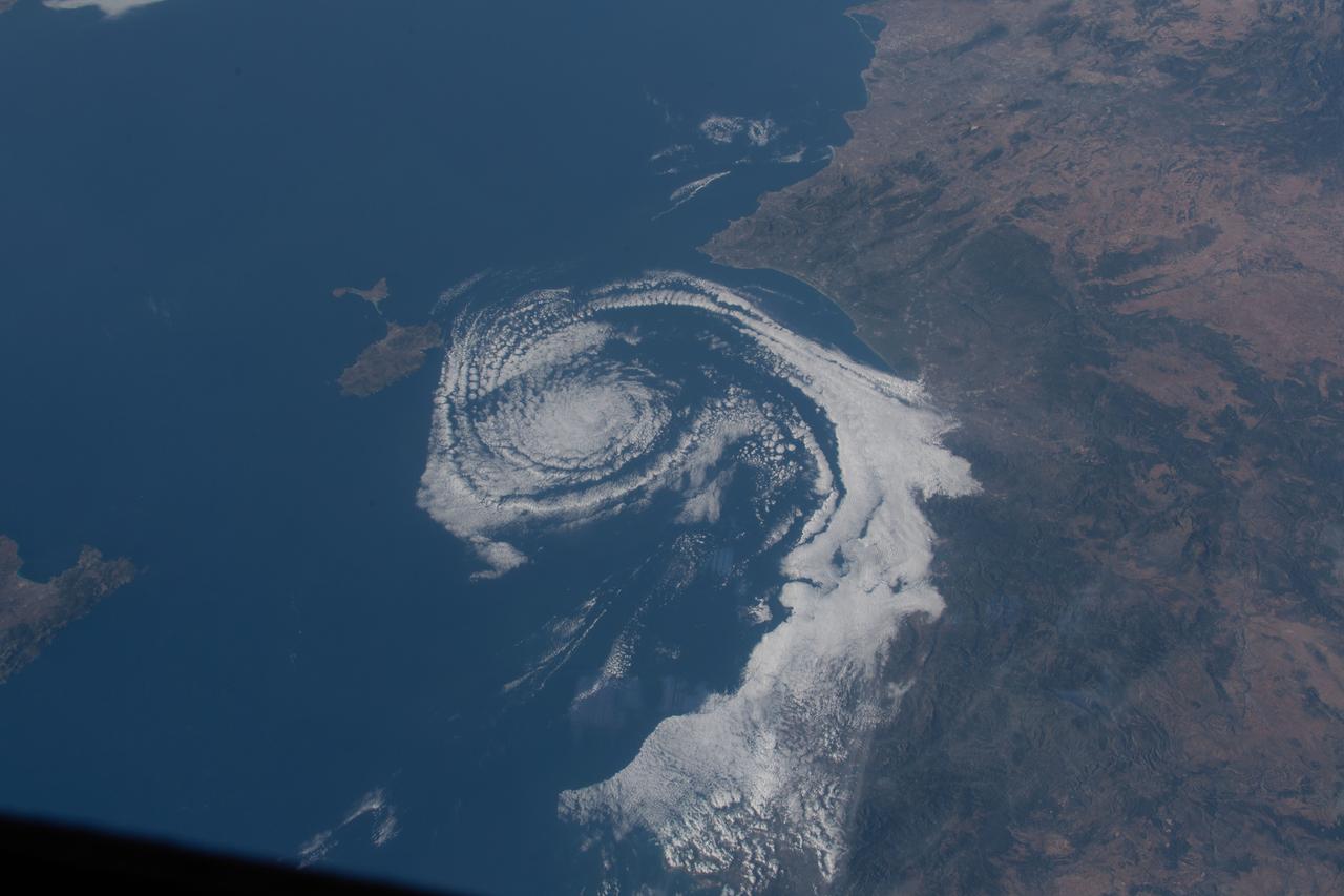
iss063e031610 (June 21, 2020) --- A cloud formation spirals in the Balearic Sea between Valencia, Spain, and the island of Ibiza as the International Space Station orbited above southern Europe.

iss062e113596 (March 22, 2020) --- The city lights of northeastern Europe sparkle beneath an aurora and a starry sky as the International Space Station orbited 263 miles above Hungary.

iss059e085130 (May 30, 2019) --- NASA astronaut Nick Hague floats inside Europe's Columbus laboratory module during a HAM radio session using the International Space Station's call sign NA1SS.
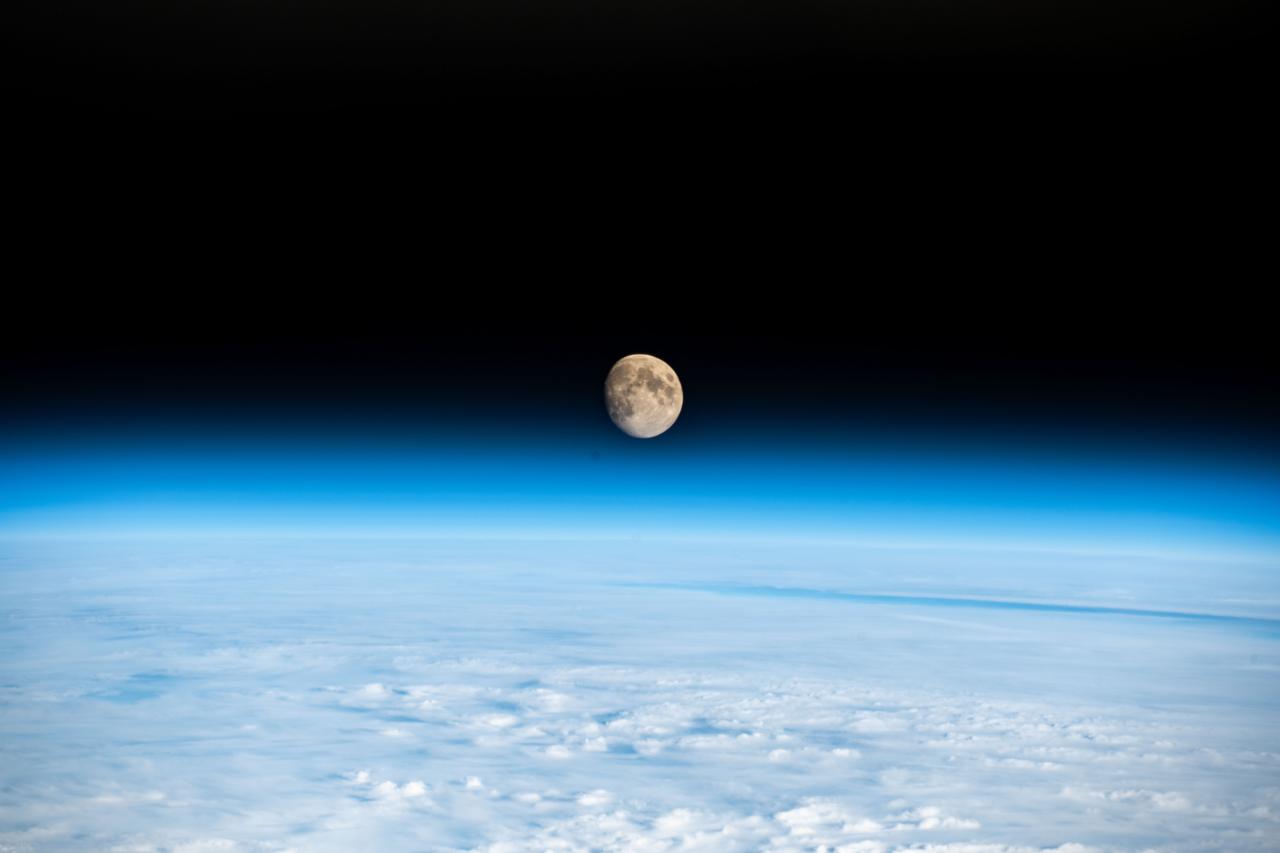
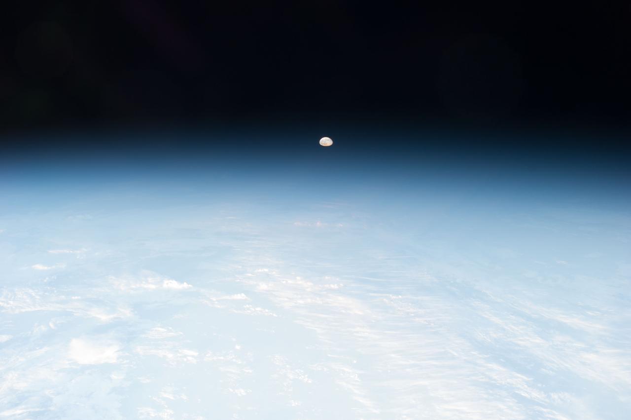
iss070e097393 (Feb. 21, 2024) --- The waxing gibbous Moon is pictured above the Earth's horizon in this photograph from the International Space Station as it orbited 262 miles above a cloudy Western Europe.
This image from NASA Terra spacecraft shows the Ural Mountains, which run 2500 km north-south through western Russia, and form the boundary between Europe and Asia. Since the 17th century, the mountains were exploited for their deposits of iron, copper, gold, coal, oil, mica and gemstones. The Urals are among the world's oldest existing mountain ranges, having been formed about 275 million years ago due to the collision of the Laurussia supercontinent with the continent of Kazakhstania. The image was acquired July 13, 2011, covers an area of 39 by 62 km, and is located near 65.5 degrees north, 59.9 degrees east. http://photojournal.jpl.nasa.gov/catalog/PIA19795
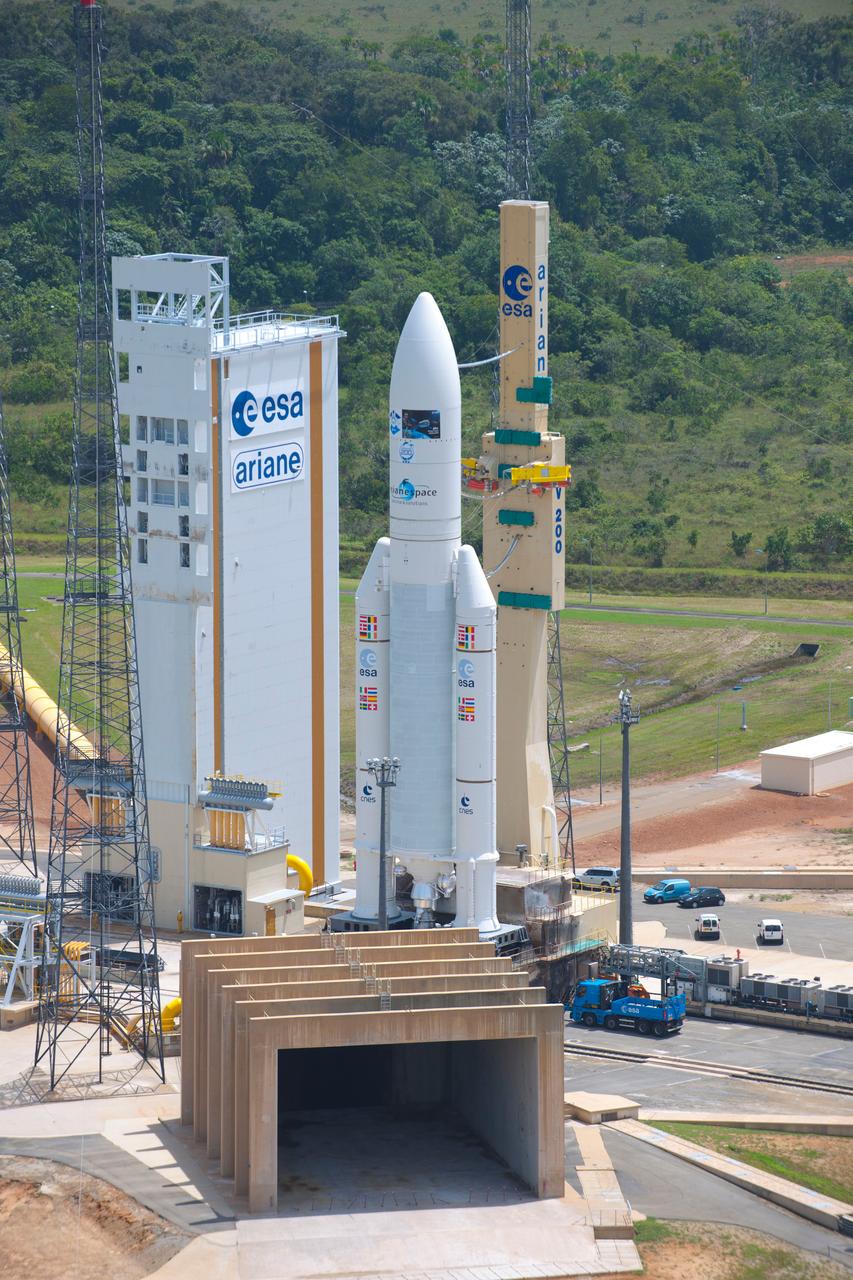
Date: 2-14-2011 Subject: Roll Out BAF to ZL 3 Photographer: Stephane Corvaja (ESA)
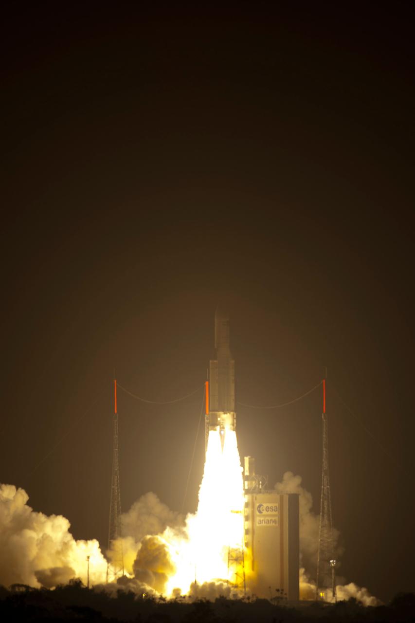
Lift Off