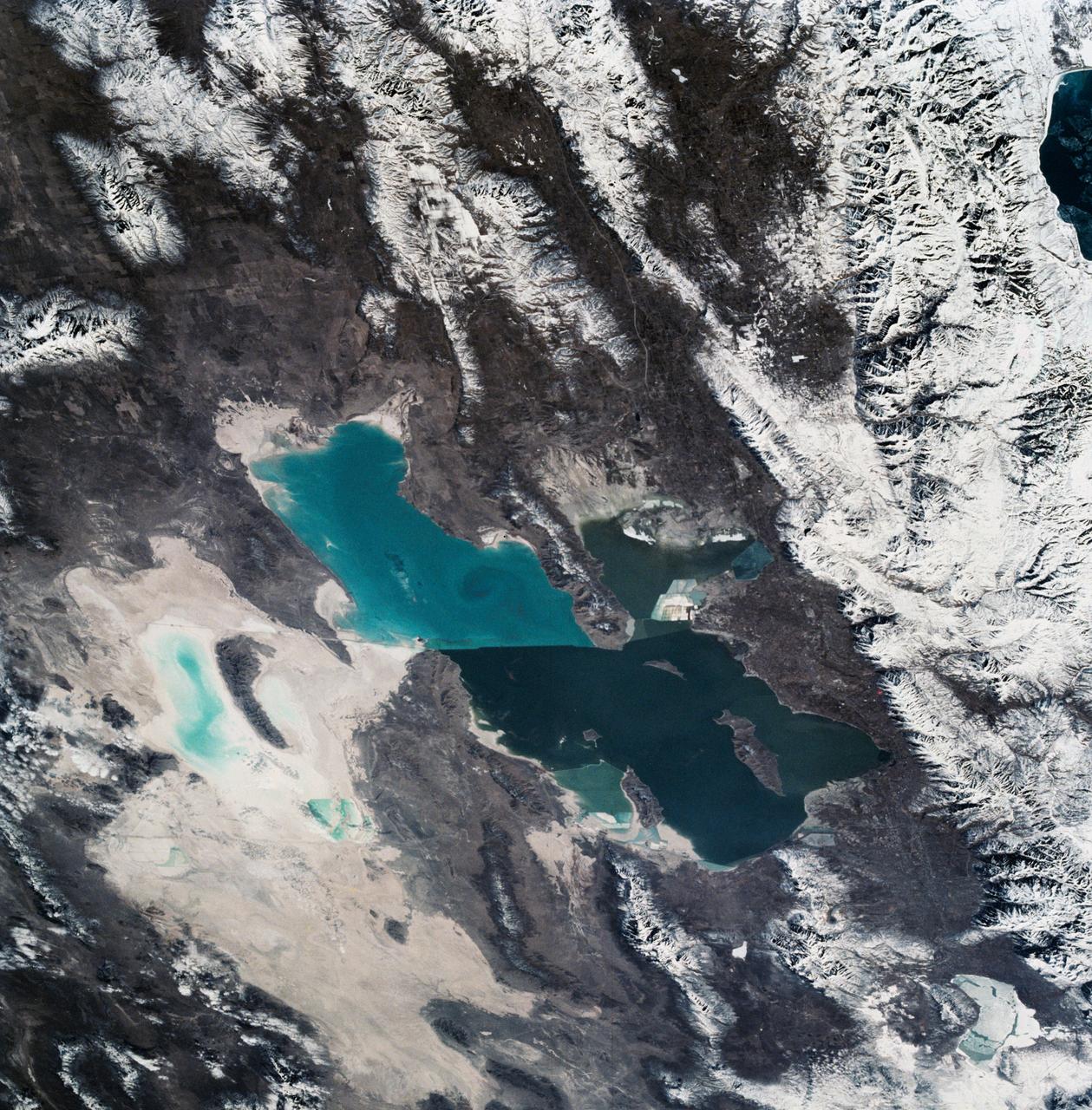
As seen from space, the Great Salt Lake, Utah, USA (41.5N, 112.5W) appears as two separate bodies of water with a narrow divider in the middle. At the turn of the century, a railroad bridge without culverts, was built across the lake and ever since, the water and salinity levels have been uneqal on either side. Fed by snowmelt from the nearby Wasatch Mountains, the lake in recent years has had record high water levels, threatening to flood the local areas.
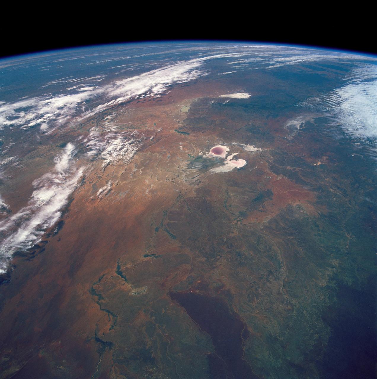
STS035-501-007 (2-10 Dec. 1990) --- The STS-35 crewmembers aboard the Earth-orbiting Space Shuttle Columbia photographed this view of the Arid Simpson Desert of Australia with a handheld Rolleiflex camera. Lake Eyre is normally dry; however, the STS-35 crew was able to recognize water in the lowest parts of the lake (dark pink area) and possibly in Lake Blanche east of Lake Eyre. Lake Frome lies in the distance separated from Lake Torrens (top right) by dark hills of Flinders Range. The Finke River (bottom left to middle) flows into the Eyre basin from the northwest. Although it is the largest river entering the basin, Finke's floods seldom reach Lake Eyre. The dark brown patch in the foreground is an area of ancient, brown lateritic soils partly covered by dunes.
Africa's Lake Chad where the borders of Chad, Niger, Nigeria and Cameroon merge (13.0N, 14.0E) has been undergoing change for the past 25 to 30 years when it was first noticed that the lake is drying up. Since then, astronauts have been photographing it on a regular basis to record the diminishing lake bed. This lake was once the aproximate size of Lake Erie but is now only about half that size and is still receeding.
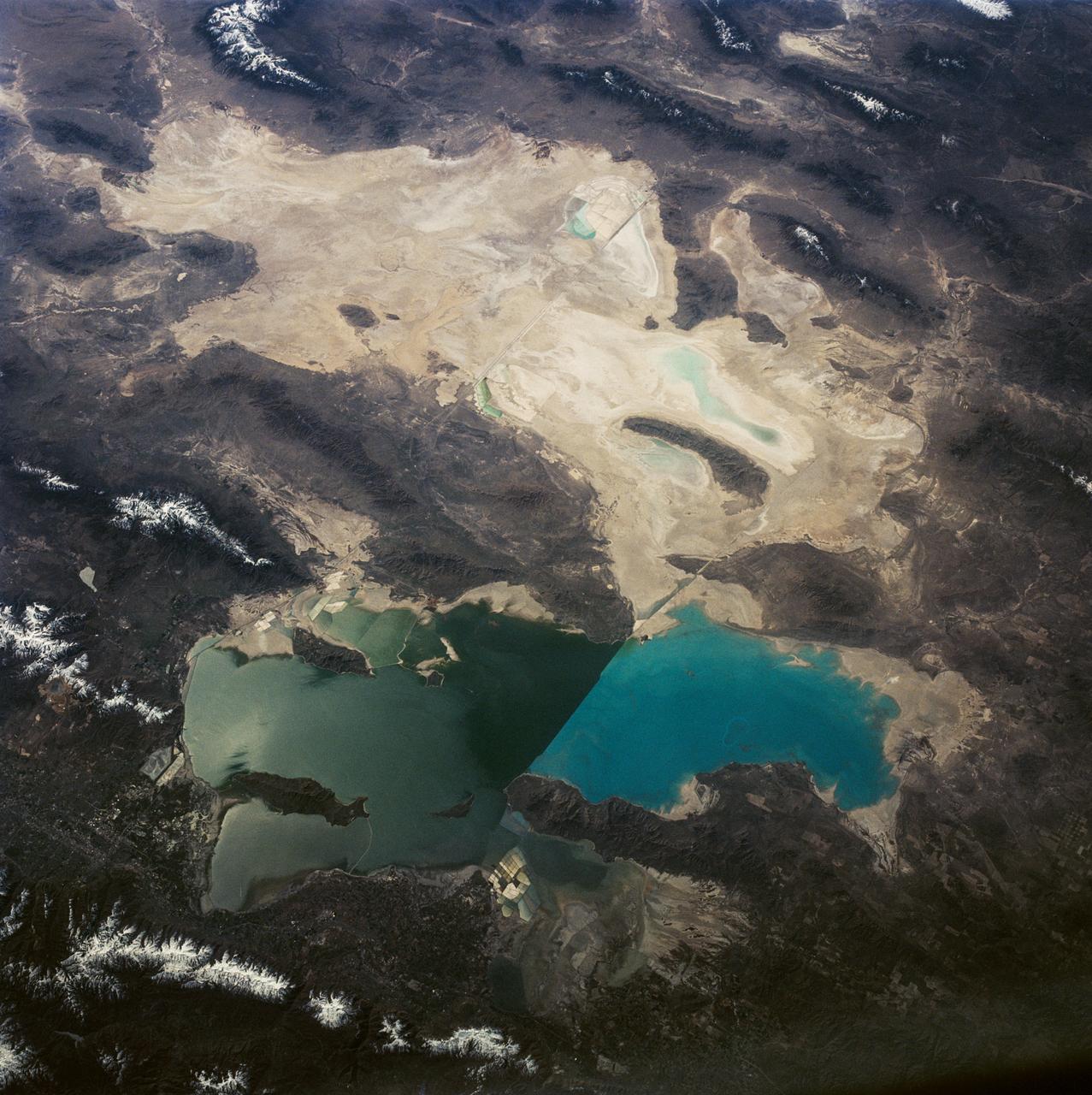
This is a view of the Great Salt Lake and nearby Bonneville Salt Flats, UT, (41.0N, 112.5W). A railroad causeway divides the lake with a stark straight line changing the water level and chemistry of the lake as a result. Fresh water runoff enters from the south adding to the depth and reducing the salinity. The north half receives little frsh water and is more saline and shallow. The Bonnieville Salt Flats is the lakebed of a onetime larger lake.
STS003-010-593 (30 March 1982) --- A general view of the greater Los Angeles region of California (34,0N, 118.5W) showing the coastline, Vandenberg AFB, the south end of the Central Valley and the dry lake beds at Edwards AFB. A close look can pinpoint water on the lake beds at Edwards Air Force Base used previously for two shuttle landings. Among other features that can be seen are Oxnard, Santa Barbara, Bakersfield, Vandenberg Air Force Base, and The Ranch. Photo credit: NASA
STS006-46-667 (9 April 1983) --- One of the final pictures taken aboard the space shuttle Challenger is this 35mm frame of Landing Strip 22 at Edwards Air Force Base as the reusable spacecraft was lined up for its landing only seconds later. The frame was exposed by astronaut Donald H. Peterson, STS-6 mission specialist, who was stretching behind the commander’s seat occupied by astronaut Paul J. Weitz on the flight deck. Also onboard the spacecraft for the five-day flight were astronauts Karol J. Bobko, pilot, and Dr. F. Story Musgrave, mission specialist. Photo credit: NASA

This image of abstract shapes is comprised numerous subparallel, very long, orange colored linear dunes and patchy grey dry lakes (playas). The dunes are aligned north to south in the great central basin of Astralia (27.0S, 138.0E). The regularity of the dunes is created by the winds blowing from the south. As the dunes advance, jaged edges on the south side of each dry lake are formed while the north side is eroded smooth by the wind and water.
The oval shaped basin of the sedimentary rocks of the Hammersley Range, northern Western Australia (23.0S, 119.0E) dominates the center of this near nadir view. The Fortescue River is the remarkably straight, fault controlled feature bordering the Hammersley on the north. Sand dunes are the main surface features in the northeast and southwest. Many dry lakebeds can be seen to the east as light grey colored patches along the watercourses.
STS054-151-015 (13-19 Jan 1993) --- The Makgadikgadi Salt Pan is one of the largest features in Botswana visible from space. Any water that spills out of the Okavango Swamplands flows down to the Makgadikgadi where it evaporates. An ancient beach line can be seen as a smooth line around the west (left) side of the Pan. Orapa diamond mine can be detected due south of the pan as a small rectangle. The large geological feature known as the Great Dike of Zimbabwe can be seen far right. This large panorama shows clouds in southern Angola, Zambia and Zimbabwe in the distance.
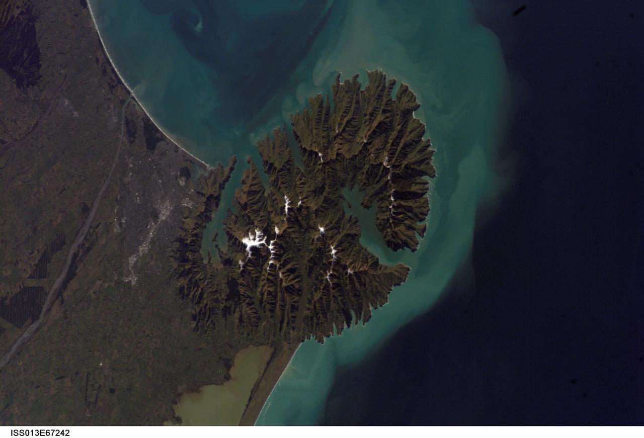
ISS013-E-67242 (15 Aug. 2006) --- Christchurch, New Zealand is featured in this image photographed by an Expedition 13 crewmember on the International Space Station. Snow highlights the peaks of the Banks Peninsula to the southeast of the city. The Peninsula has a radically different landscape compared to the adjoining flat Canterbury Plains on which Christchurch is situated. This is a result of the geology of the Banks Peninsula -- it is formed from the overlapping cones of the extinct Lyttelton and Akaroa volcanoes. Subsequent erosion of the cones formed the heavily dissected terrain visible in the image, and sea level rise led to the creation of several harbors around the Peninsula. Erosion continues unabated today, as evidenced by the apron of greenish blue sediment-laden waters surrounding the Banks Peninsula. Other features of interest in the image include the braided Waimakariri River to the north-northwest of the city, and the greenish brown waters of Lake Ellesmere. The coloration of the water is due both to its shallow depth (1.4 meters average) and its high concentrations of nitrogen and phosphorus - conditions which lead to a high abundance of green algae.
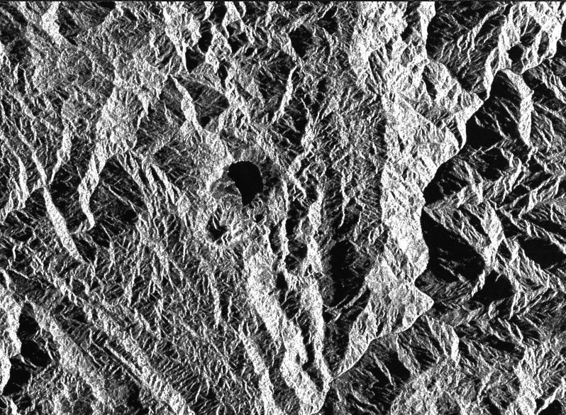
This is a radar image of a little known volcano in northern Colombia. The image was acquired on orbit 80 of space shuttle Endeavour on April 14, 1994, by NASA Spaceborne Imaging Radar C/X-Band Synthetic Aperture Radar SIR-C/X-SAR. The volcano near the center of the image is located at 5.6 degrees north latitude, 75.0 degrees west longitude, about 100 kilometers (65 miles) southeast of Medellin, Colombia. The conspicuous dark spot is a lake at the bottom of an approximately 3-kilometer-wide (1.9-mile) volcanic collapse depression or caldera. A cone-shaped peak on the bottom left (northeast rim) of the caldera appears to have been the source for a flow of material into the caldera. This is the northern-most known volcano in South America and because of its youthful appearance, should be considered dormant rather than extinct. The volcano's existence confirms a fracture zone proposed in 1985 as the northern boundary of volcanism in the Andes. The SIR-C/X-SAR image reveals another, older caldera further south in Colombia, along another proposed fracture zone. Although relatively conspicuous, these volcanoes have escaped widespread recognition because of frequent cloud cover that hinders remote sensing imaging in visible wavelengths. Four separate volcanoes in the Northern Andes nations of Colombia and Ecuador have been active during the last 10 years, killing more than 25,000 people, including scientists who were monitoring the volcanic activity. Detection and monitoring of volcanoes from space provides a safe way to investigate volcanism. The recognition of previously unknown volcanoes is important for hazard evaluations because a number of major eruptions this century have occurred at mountains that were not previously recognized as volcanoes. http://photojournal.jpl.nasa.gov/catalog/PIA01722