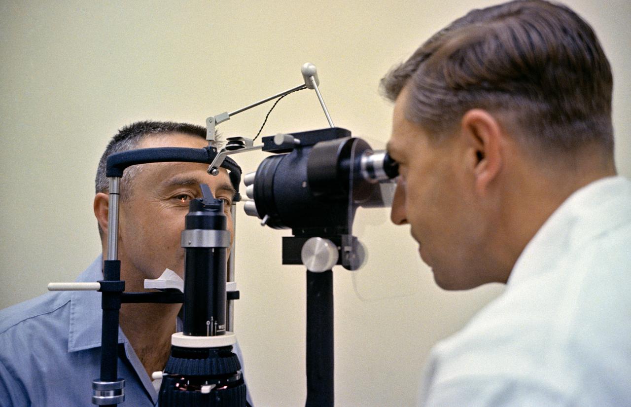
S65-66703 (18 Dec. 1965) --- Astronaut James A. Lovell Jr., pilot of the National Aeronautics and Space Administration's Gemini-7 spaceflight, undergoes an eye examination during a postflight medical checkup aboard the aircraft carrier USS Wasp. Gemini-7 splashed down in the western Atlantic recovery area at 9:05 a.m. (EST) Dec. 16, 1965, after a 14-day mission in space. Photo credit: NASA
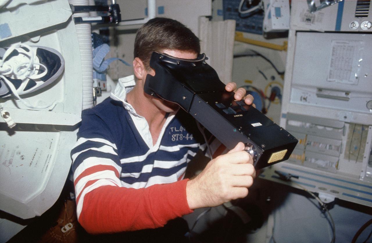
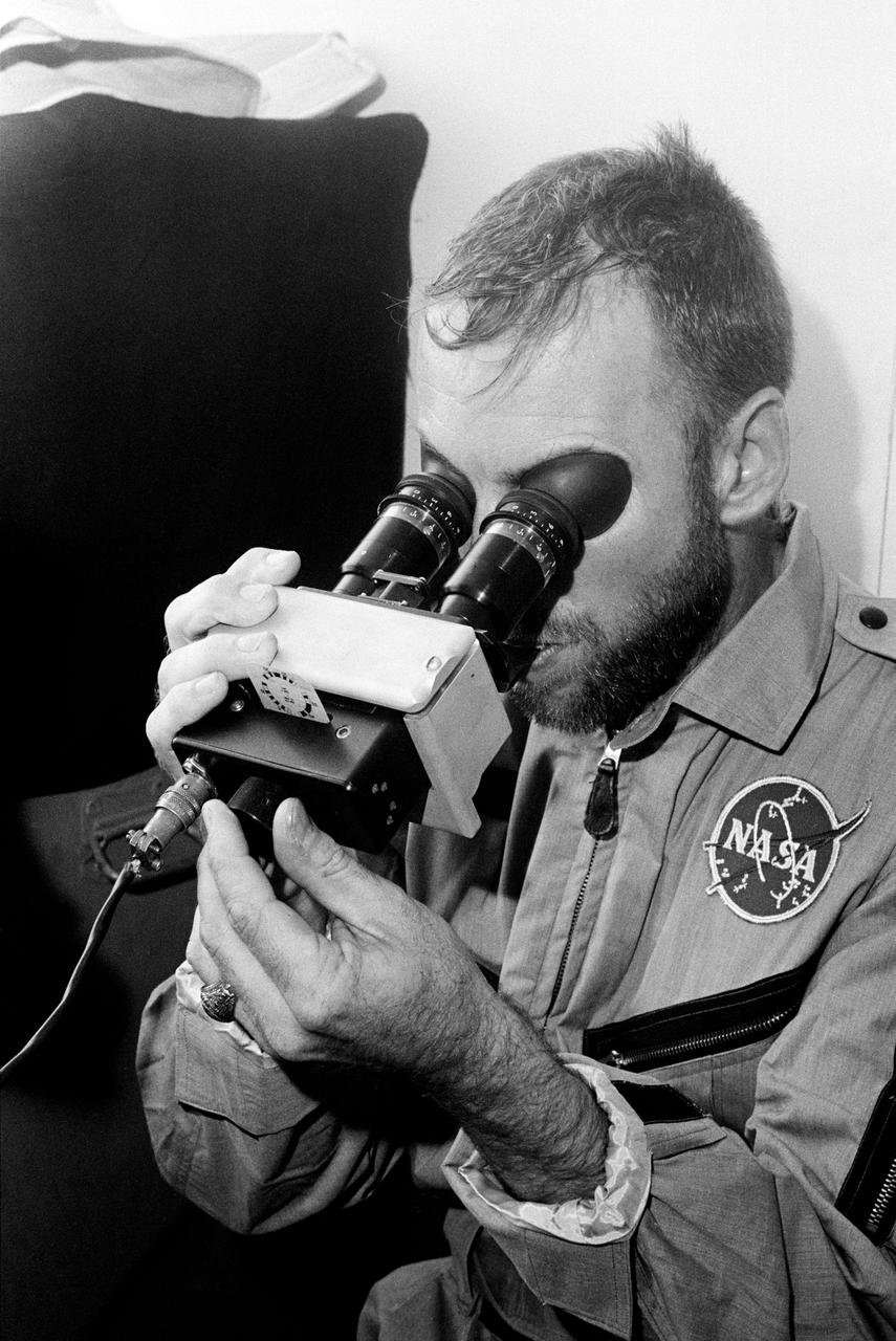
STS044-14-013 (24 Nov-1 Dec 1991) --- Terence T. (Tom) Henricks, STS-44 pilot, tests his visual acuity with the Visual Function Test (VFT) apparatus. This photograph was among the first released by NASA following the eight day mission, dedicated to the Department of Defense.
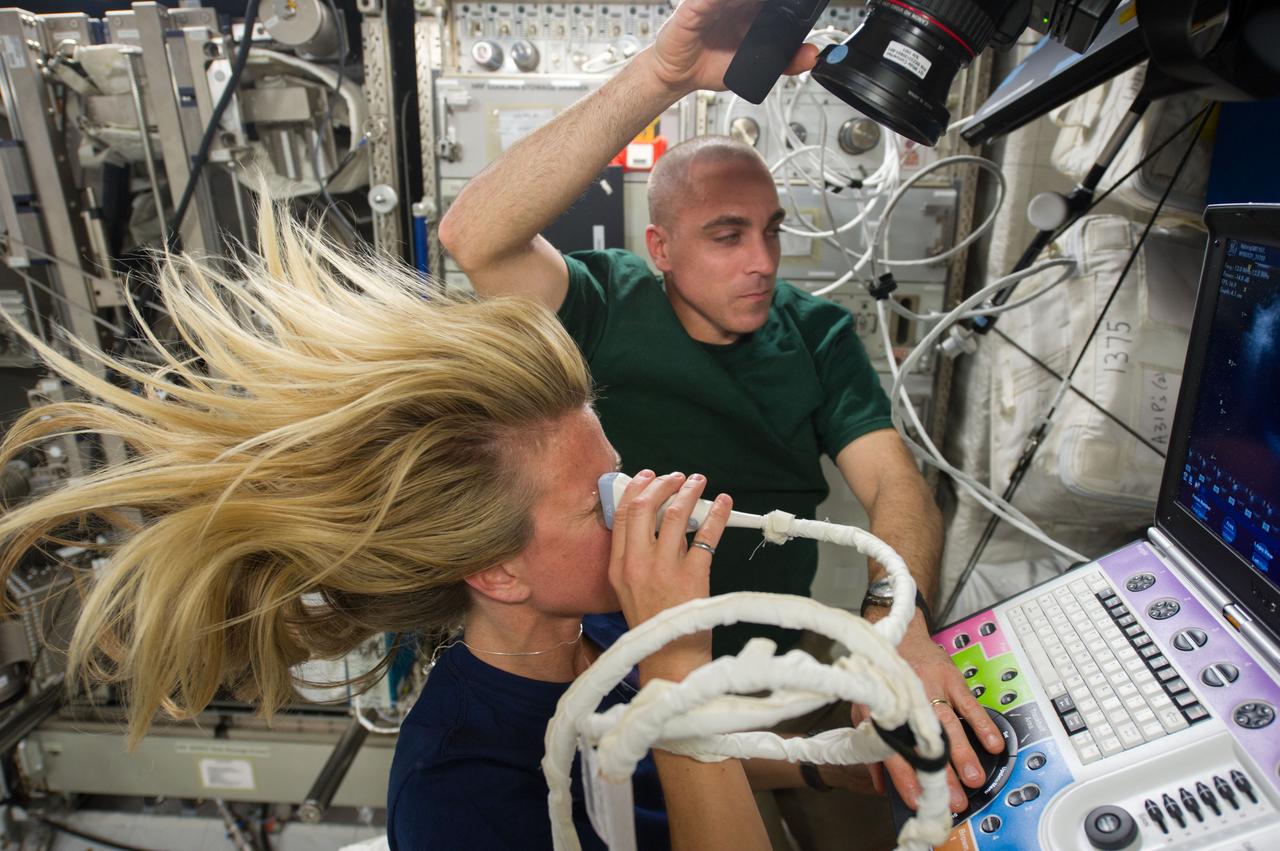
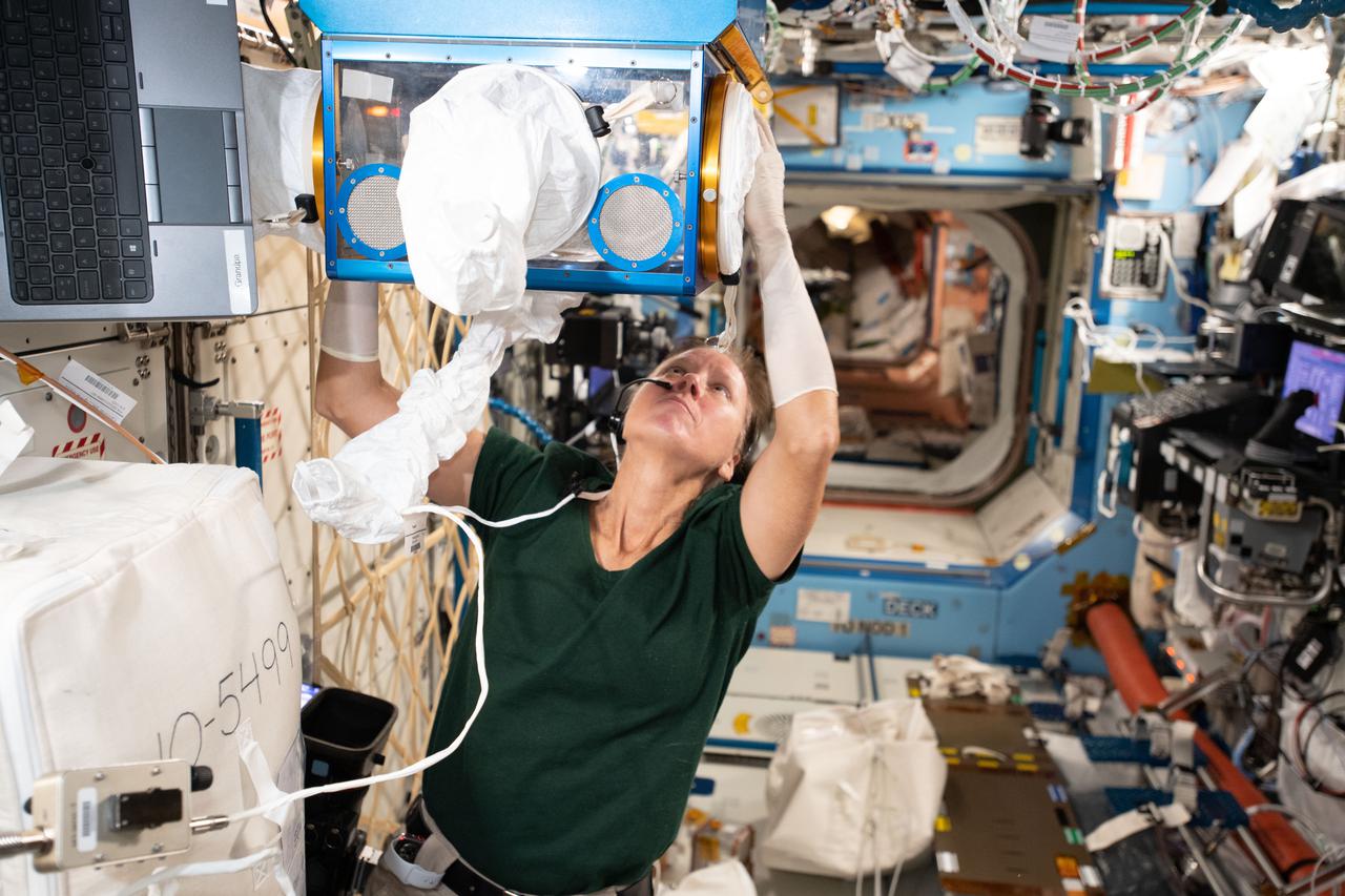
Astronaut Karen Nyberg,Expedition 37 flight engineer, assisted by astronaut Chris Cassidy, performs an Ocular Health (OH) Ultrasound 2 scan in the Destiny laboratory of the International Space Station.
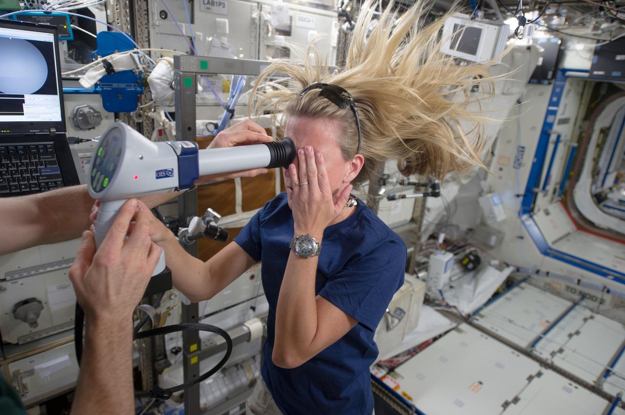
Astronaut Karen Nyberg and Astronaut Chris Cassidy (partially visible), both Expedition 37 flight engineers, perform an Ocular Health (OH) Fundoscope Exam in the Destiny laboratory of the International Space Station
S65-20429 (21 March 1965) --- Astronaut Virgil I. Grissom, command pilot for the Gemini-Titan 3 mission, receives an eye examination during the physical given to the GT-3 crew two days before launch.
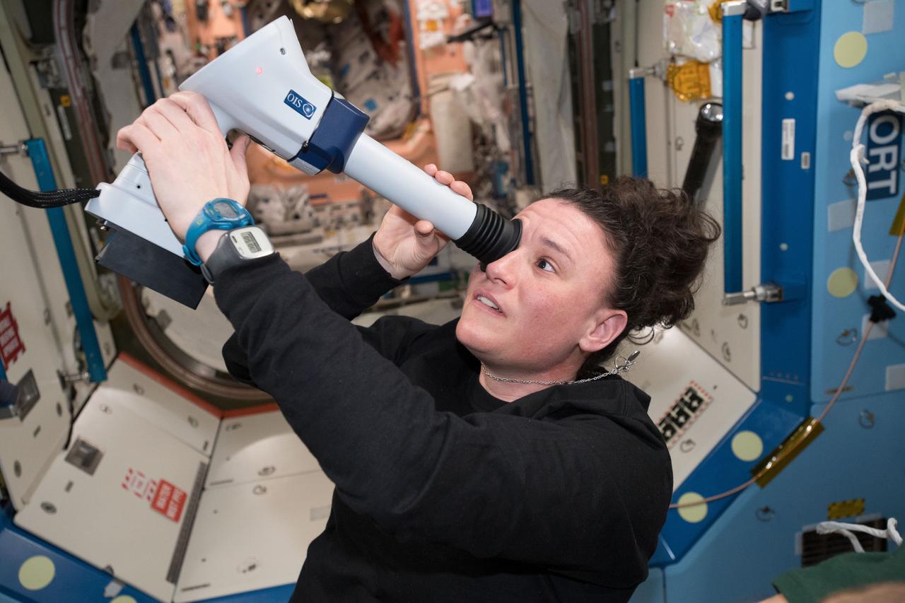
iss056e096896 (July 13, 2018) --- Astronaut Serena Auñón-Chancellor examines her eye with a Fundoscope aboard the International Space Station with remote support from doctors on the ground.
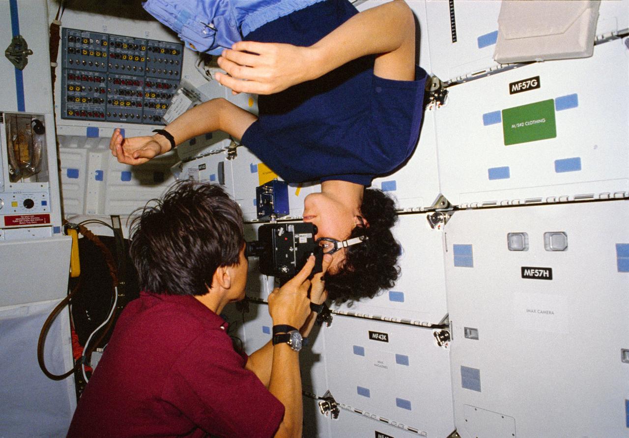
STS034-10-015 (18-23 Oct. 1989) --- Astronaut Franklin R. Chang-Diaz performs an eye examination on astronaut Ellen S. Baker, both STS-34 mission specialists, on the middeck of the Earth-orbiting space shuttle Atlantis.

ISS039-E-010403 (8 April 2014) --- Expedition 39 Commander Koichi Wakata of the Japan Aerospace Exploration Agency (JAXA) works with computers in the Harmony node of the International Space Station to prepare for Optical Coherence Tomography (OCT) eye examinations for the Optical Health experiment.
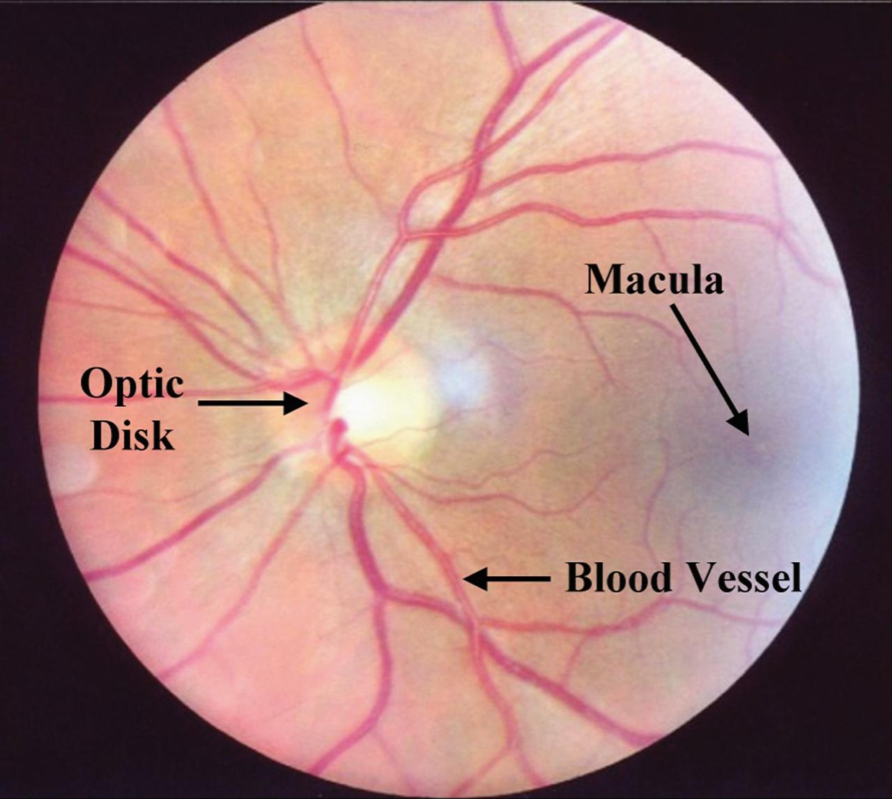
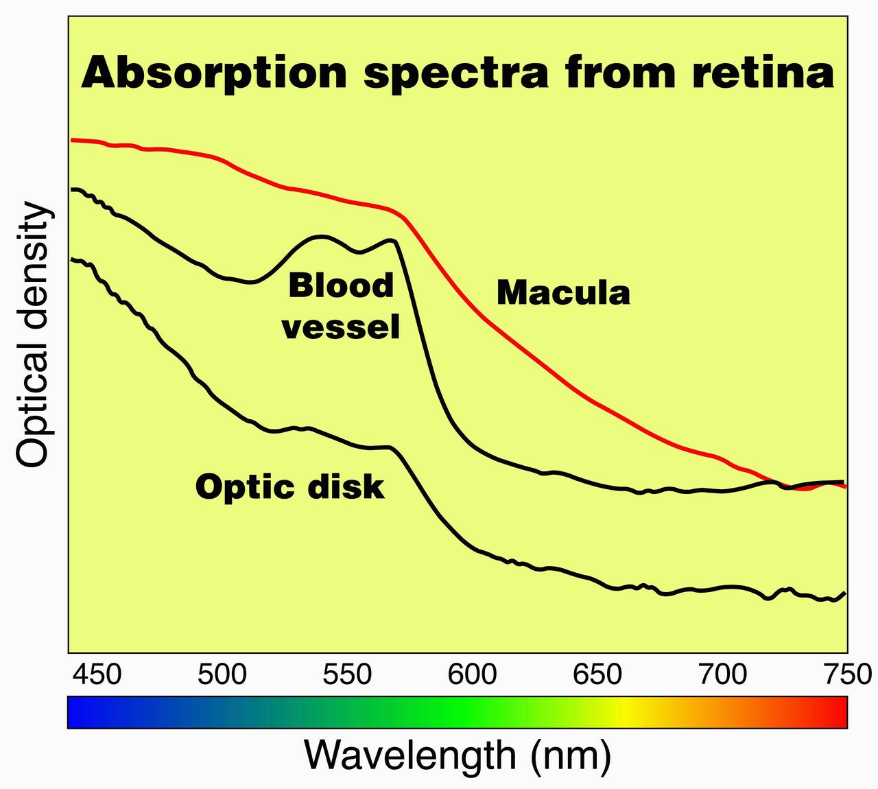
ProVision Technologies, a NASA commercial space center at Sternis Space Center in Mississippi, has developed a new hyperspectral imaging (HSI) system that is much smaller than the original large units used aboard remote sensing aircraft and satellites. The new apparatus is about the size of a breadbox. HSI may be useful to ophthalmologists to study and diagnose eye health, both on Earth and in space, by examining the back of the eye to determine oxygen and blood flow quickly and without any invasion. ProVision's hyperspectral imaging system can scan the human eye and produce a graph showing optical density or light absorption, which can then be compared to a graph from a normal eye. Scans of the macula, optic disk or optic nerve head, and blood vessels can be used to detect anomalies and identify diseases in this delicate and important organ. ProVision has already developed a relationship with the University of Alabama at Birmingham, but is still on the lookout for a commercial partner in this application.
ProVision Technologies, a NASA research partnership center at Sternis Space Center in Mississippi, has developed a new hyperspectral imaging (HSI) system that is much smaller than the original large units used aboard remote sensing aircraft and satellites. The new apparatus is about the size of a breadbox. HSI may be useful to ophthalmologists to study and diagnose eye health, both on Earth and in space, by examining the back of the eye to determine oxygen and blood flow quickly and without any invasion. ProVision's hyperspectral imaging system can scan the human eye and produce a graph showing optical density or light absorption, which can then be compared to a graph from a normal eye. Scans of the macula, optic disk or optic nerve head, and blood vessels can be used to detect anomalies and identify diseases in this delicate and important organ. ProVision has already developed a relationship with the University of Alabama at Birmingham, but is still on the lookout for a commercial partner in this application.
The Rodent Research-23 investigation, worked on above by Walker, makes valuable contributions to biomedicine. This work examined the effects of microgravity on veins, arteries, and lymphatic structures of the eye, which helps address visual impairment issues from Spaceflight-Associated Neuro-ocular Syndrome (SANS). Over 40% of astronauts experience SANS during long-duration missions.
Cumulative driving by NASA's Mars Exploration Rover Opportunity surpassed marathon distance on March 24, 2015, as the rover neared a destination called "Marathon Valley," which is middle ground of this stereo view from early March. The scene appears three-dimensional when viewed through blue-red glasses with the red lens on the left. Olympic marathon distance is 26.219 miles (42.195 kilometers). The left-eye and right-eye cameras of Opportunity's navigation camera collected the component images of this scene during the 3,948th and 3,949th Martian days, or sols, of the rover's work on Mars (March 3 and 4, 2015). The view is centered toward the east-southeast, from a location on Endeavour Crater's western rim overlooking Marathon Valley, with the floor of Endeavour beyond, and the eastern rim in the distance. In the foreground at center, Opportunity's robotic arm is positioned for examination of a blocky rock called "Sergeant Charles Floyd." http://photojournal.jpl.nasa.gov/catalog/PIA19156
Under the watchful eyes of workers at Launch Pad 17A, Cape Canaveral Air Station (CCAS), the second stage of a Boeing Delta II rocket is lowered toward the first stage below. The first and second stages will be mated for the launch, targeted on June 23 at CCAS, , of NASA's Far Ultraviolet Spectroscopic Explorer (FUSE) satellite. FUSE was developed by The Johns Hopkins University under contract to Goddard Space Flight Center, Greenbelt, Md., to investigate the origin and evolution of the lightest elements in the universe hydrogen and deuterium. In addition, the FUSE satellite will examine the forces and process involved in the evolution of the galaxies, stars and planetary systems by investigating light in the far ultraviolet portion of the electromagnetic spectrum
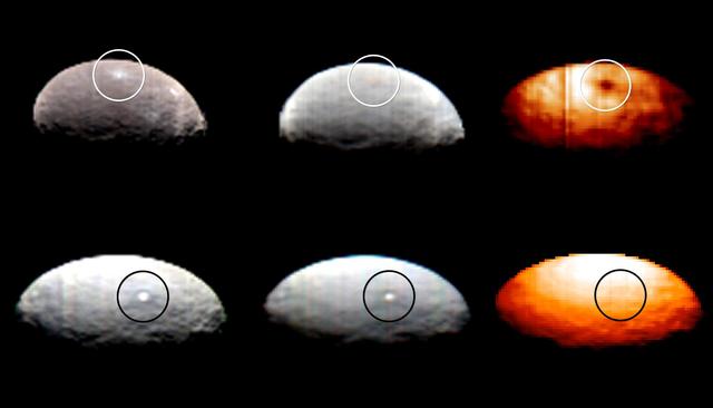
These images, from Dawn's visible and infrared mapping spectrometer (VIR), highlight two regions on Ceres containing bright spots. The top images feature a bright spot scientists have labeled "1" (located at around 4 degrees north, 8 degrees east on Ceres' surface); the bottom images feature the spot labeled "5" (located at around 20 degrees north, 240 degrees east). Spot 5 actually contains two spots, which are the brightest on Ceres. Each row shows Ceres' surface at different wavelengths. At left are images taken in visible light, close to wavelengths seen by the human eye. The center images show the same regions of Ceres in wavelengths shifted to the infrared range. The two images at right show Ceres in thermal infrared, where brighter colors represent higher temperatures. During Dawn's arrival at Ceres, VIR has been examining the relative temperatures of features on the dwarf planet's surface. Preliminary examination suggests that region 1 is cooler than the rest of Ceres' surface, but region 5 appears to be located in a region that is similar in temperature to its surroundings. The images were captured on February 19, 2015, when Dawn was nearly 29,000 miles (46,000 kilometers) from Ceres. Image scale on Ceres is about 7 miles (11 kilometers) per pixel. http://photojournal.jpl.nasa.gov/catalog/PIA19316
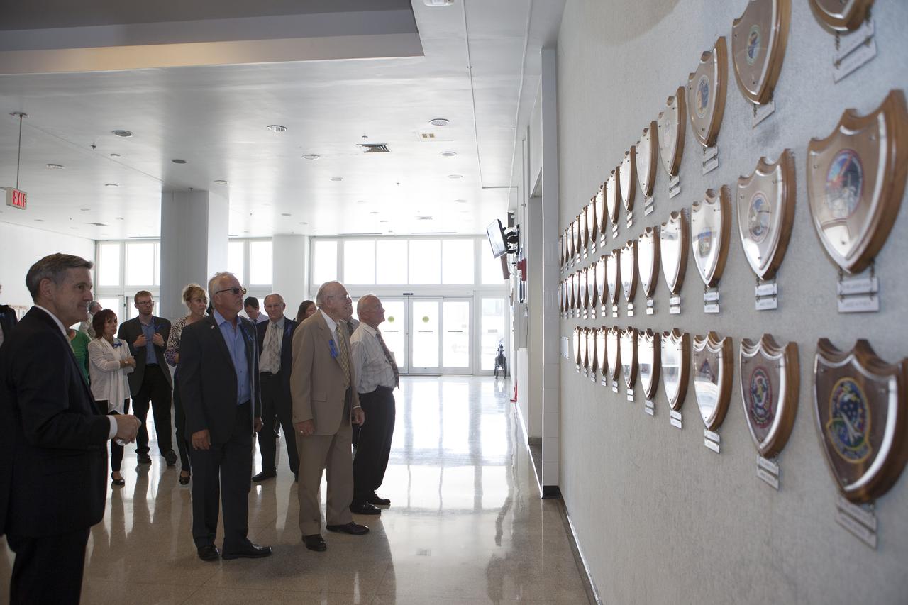
CAPE CANAVERAL, Fla. -- Apollo astronauts and their families examine the mission plaques mounted on the wall in the lobby of the Launch Control Center at NASA's Kennedy Space Center in Florida. The facility houses the firing rooms from which the Apollo countdowns were conducted. Kennedy Director Robert Cabana, at left, led the tour which followed a ceremony renaming the refurbished Operations and Checkout Building for Apollo 11 astronaut Neil Armstrong, the first person to set foot on the moon. The ceremony was part of NASA's 45th anniversary celebration of the Apollo 11 moon landing. As the world watched, Neil Armstrong and Buzz Aldrin landed in the moon's Sea of Tranquility on July 20, 1969, aboard the lunar module Eagle. Meanwhile, crewmate Michael Collins orbited above in the command module Columbia. For more, visit http://www.nasa.gov/press/2014/july/nasa-honors-historic-first-moon-landing-eyes-first-mars-mission. Photo credit: NASA/Kim Shiflett
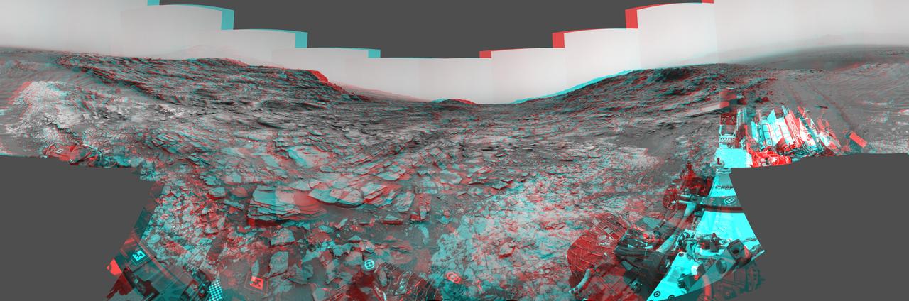
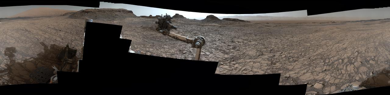
This stereo view from the Navigation Camera (Navcam) on NASA's Curiosity Mars rover shows a 360-degree panorama around the location where the rover spent its 1,000th Martian day, or sol, on Mars. The image appears three-dimensional when viewed through red-blue glasses with the red lens on the left. Sol 1,000 of Curiosity's Mars-surface mission corresponded to May 30, 2015. The component images for this scene were taken on Sol 997 (May 27, 2015). The site is a valley just below "Marias Pass" on lower Mount Sharp. A map of the area is at http://mars.nasa.gov/msl/images/Curiosity_Location_Sol997-full.jpg. The center of the scene is toward the south, with north at both ends. This stereo view combines images from Navcam left-eye and right-eye cameras. A single-eye version of the scene is at PIA19679 . Tracks from the rover's drive to this site are visible at right. The rover team chose this location near Marias Pass because images from orbit showed what appeared to be a contact between two types of bedrock. The two types are evident in this panorama. The bedrock close to the rover is pale mudstone similar to what Curiosity examined in 2014 and early 2015 at "Pahrump Hills." The darker, finely bedded bedrock above it is sandstone that the rover team calls the "Stimson" unit. The largest-looking slab of Stimson sandstone in the image, in the lower left quadrant, is a target called "Ronan," selected for close-up inspection. on lower Mount Sharp. http://photojournal.jpl.nasa.gov/catalog/PIA19678
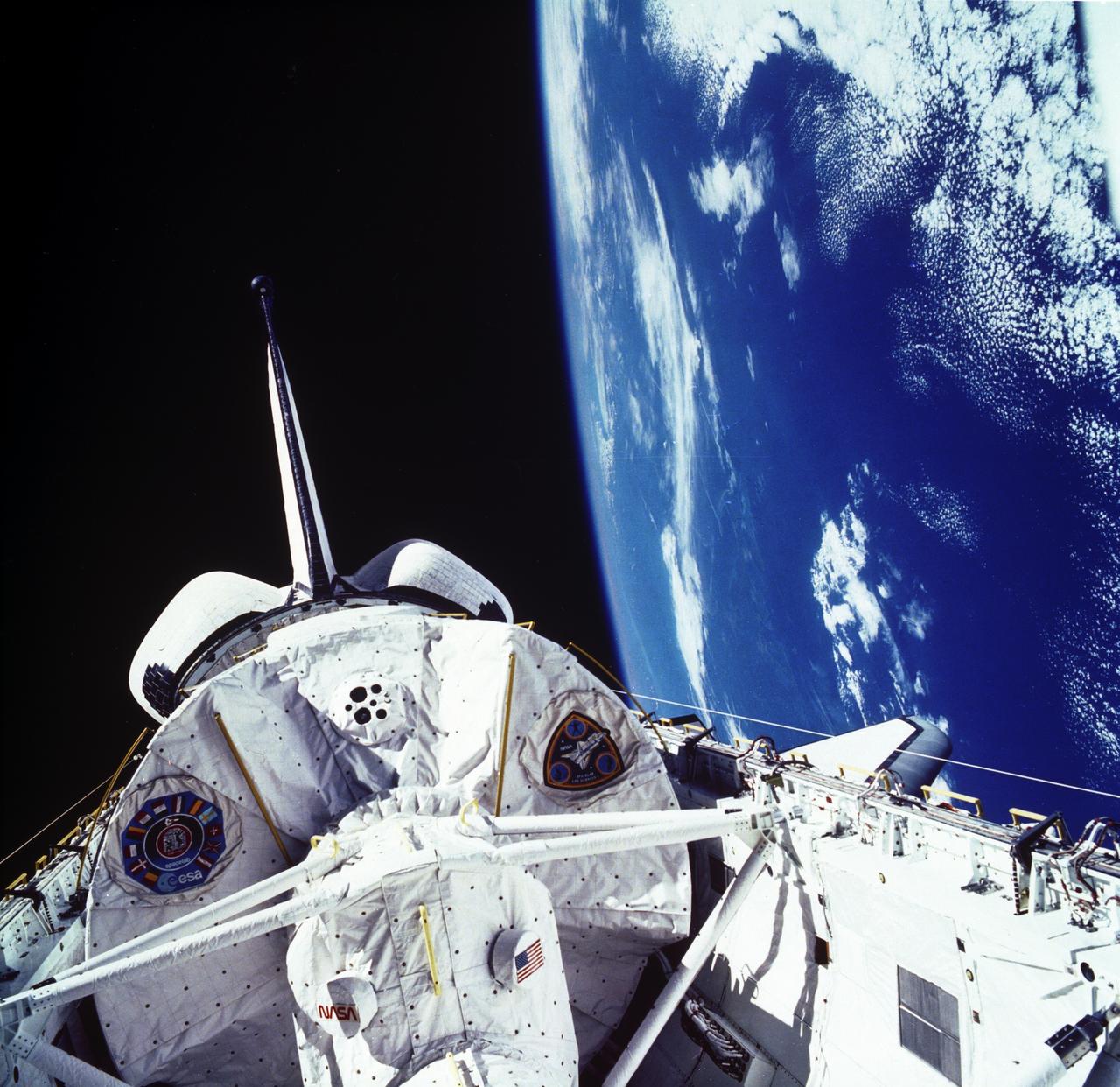
The laboratory module in the cargo bay of the Space Shuttle Orbiter Columbia was photographed during the Spacelab Life Science-1 (SLS-1) mission. SLS-1 was the first Spacelab mission dedicated solely to life sciences. The main purpose of the SLS-1 mission was to study the mechanisms, magnitudes, and time courses of certain physiological changes that occur during space flight, to investigate the consequences of the body's adaptation to microgravity and readjustment to Earth's gravity, and to bring the benefits back home to Earth. The mission was designed to explore the responses of the heart, lungs, blood vessels, kidneys, and hormone-secreting glands to microgravity and related body fluid shifts; examine the causes of space motion sickness; and study changes in the muscles, bones and cells. The five body systems being studied were: The Cardiovascular/Cardiopulmonary System (heart, lungs, and blood vessels), the Renal/Endocrine System (kidney and hormone-secreting organs), the Immune System (white blood cells), the Musculoskeletal System (muscles and bones), and the Neurovestibular System (brain and nerves, eyes, and irner ear). The SLS-1 was launched aboard the Space Shuttle Orbiter Columbia (STS-40) on June 5, 1995.
This view from the Mast Camera (Mastcam) on NASA's Curiosity Mars rover shows a site where two different types of bedrock meet on lower Mount Sharp. The scene combines multiple images taken by the left-eye camera of Mastcam on May 25, 2015, during the 995th Martian day, or sol, of Curiosity's work on Mars, in a valley just below "Marias Pass." The color has been approximately white-balanced to resemble how the scene would appear under daytime lighting conditions on Earth. The paler part of the outcrop, in the foreground, is mudstone similar to what Curiosity examined in 2014, and in early 2015, at "Pahrump Hills." The darker, finely bedded bedrock higher in the image and overlying the mudstone stratigraphically is sandstone that the rover team calls the "Stimson" unit. The scene covers an area about 10 feet (3 meters) wide in the foreground. Malin Space Science Systems, San Diego, built and operates the rover's Mastcam. NASA's Jet Propulsion Laboratory, a division of the California Institute of Technology, Pasadena, manages the Mars Science Laboratory Project for NASA's Science Mission Directorate, Washington. http://photojournal.jpl.nasa.gov/catalog/PIA19676
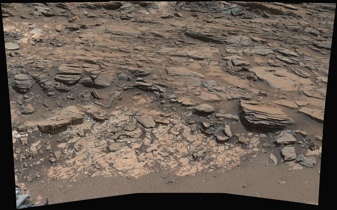
This view from the Mast Camera (Mastcam) on NASA's Curiosity Mars rover shows a site with a network of prominent mineral veins below a cap rock ridge on lower Mount Sharp. Researchers used the rover in March 2015 to examine the structure and composition of the crisscrossing veins at the "Garden City" site in the center of this scene. For geologists, the vein complex offers a three-dimensional exposure of mineralized fractures in a geological setting called the Pahrump section of the Lower Murray Formation. Curiosity spent several months examining sites in the Pahrump section below this site, before arriving at Garden City. Mineral veins such as these form where fluids move through fractured rocks, depositing minerals in the fractures and affecting chemistry of the surrounding rock. In this case, the veins have been more resistant to erosion than the surrounding host rock. The component images of this mosaic view were taken by the left-eye camera of Mastcam on March 27, 2015, during the 938th Martian day, or sol, of Curiosity's work on Mars. The scene is presented with a color adjustment that approximates white balancing, to resemble how the rocks would appear under daytime lighting conditions on Earth. For scale, the cap rock scarp is about 3 feet (1 meter) tall. Figure 1 includes scale bars of 1 meter (3.3 feet) vertically and 2 meters (6.7 feet) horizontally. Malin Space Science Systems, San Diego, built and operates Curiosity's Mastcam. NASA's Jet Propulsion Laboratory, a division of the California Institute of Technology, Pasadena, built the rover and manages the project for NASA's Science Mission Directorate, Washington. http://photojournal.jpl.nasa.gov/catalog/PIA19921
This detailed panorama from the Mast Camera (Mastcam) on NASA's Curiosity Mars rover shows a view toward two areas on lower Mount Sharp chosen for close-up inspection: "Mount Shields" and "Logan Pass." The scene is a mosaic of images taken with Mastcam's right-eye camera, which has a telephoto lens, on April 16, 2015, during the 957th Martian day, or sol, of Curiosity's work on Mars, before that sol's drive. The view spans from southwest, at left, to west-northwest. The color has been approximately white-balanced to resemble how the scene would appear under daytime lighting conditions on Earth. By 10 sols later, Curiosity had driven about 328 meters (1,076 feet) from the location where it made this observation to an outcrop at the base of "Mount Shields." A 5-meter scale bar has been superimposed near the center of this scene beside the outcrop that the rover then examined in detail. (Five meters is 16.4 feet.) This study location was chosen on the basis of Mount Shields displaying a feature that geologists recognized from images like this as likely to be a site where an ancient valley was incised into bedrock, then refilled with other sediment. After a few sols examining the outcrop at the base of Mount Shields, Curiosity resumed driving toward a study area at Logan Pass, near the 5-meter scale bar in the left half of this scene. That location was selected earlier, on the basis of images from orbit indicating contact there between two different geological units. The rover's route from Mount Shields to Logan Pass runs behind "Jocko Butte" from the viewpoint where this panorama was taken. http://photojournal.jpl.nasa.gov/catalog/PIA19398
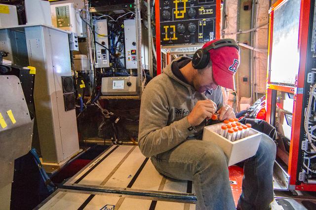
Scientist Ewan Crosbie has developed a mechanism for sampling actual cloud droplets in flight. Here he’s labeling his test vials for future examination in ground based labs. --- The <b><a href="http://naames.larc.nasa.gov/" rel="nofollow">North Atlantic Aerosols and Marine Ecosystems Study </a></b> (NAAMES) is a five year investigation to resolve key processes controlling ocean system function, their influences on atmospheric aerosols and clouds and their implications for climate. Michael Starobin joined the NAAMES field campaign on behalf of Earth Expeditions and NASA Goddard Space Flight Center’s Office of Communications. He presented stories about the important, multi-disciplinary research being conducted by the NAAMES team, with an eye towards future missions on the NASA drawing board. This is a NAAMES photo essay put together by Starobin, a collection of 49 photographs and captions. Photo and Caption Credit: Michael Starobin <b><a href="http://www.nasa.gov/audience/formedia/features/MP_Photo_Guidelines.html" rel="nofollow">NASA image use policy</a></b> <b><a href="http://www.nasa.gov/centers/goddard/home/index.html" rel="nofollow">NASA Goddard Space Flight Center</a></b> enables NASA’s mission through four scientific endeavors: Earth Science, Heliophysics, Solar System Exploration, and Astrophysics. Goddard plays a leading role in NASA’s accomplishments by contributing compelling scientific knowledge to advance the Agency’s mission. <b>Follow us on <a href="http://twitter.com/NASAGoddardPix" rel="nofollow">Twitter</a></b> <b>Like us on <a href="http://www.facebook.com/pages/Greenbelt-MD/NASA-Goddard/395013845897?ref=tsd" rel="nofollow">Facebook</a></b> <b>Find us on <a href="https://www.instagram.com/nasagoddard/?hl=en" rel="nofollow">Instagram</a></b>
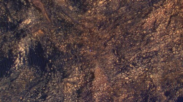
The feature that appears bright blue at the center of this scene is NASA's Curiosity Mars rover on the northwestern flank of Mount Sharp, viewed by NASA's Mars Reconnaissance Orbiter. Curiosity is approximately 10 feet long and 9 feet wide (3.0 meters by 2.8 meters). The view is a cutout from observation ESP_050897_1750 taken by the High Resolution Imaging Science Experiment (HiRISE) camera on the orbiter on June 5, 2017. HiRISE has been imaging Curiosity about every three months, to monitor the surrounding features for changes such as dune migration or erosion. When the image was taken, Curiosity was partway between its investigation of active sand dunes lower on Mount Sharp, and "Vera Rubin Ridge," a destination uphill where the rover team intends to examine outcrops where hematite has been identified from Mars orbit. The rover's surroundings include tan rocks and patches of dark sand. As in previous HiRISE color images of Curiosity since the rover was at its landing site, the rover appears bluer than it really is. HiRISE color observations are recorded in a red band, a blue-green band and an infrared band, and displayed in red, green and blue. This helps make differences in Mars surface materials apparent, but does not show natural color as seen by the human eye. Lower Mount Sharp was chosen as a destination for the Curiosity mission because the layers of the mountain offer exposures of rocks that record environmental conditions from different times in the early history of the Red Planet. Curiosity has found evidence for ancient wet environments that offered conditions favorable for microbial life, if Mars has ever hosted life. https://photojournal.jpl.nasa.gov/catalog/PIA21710
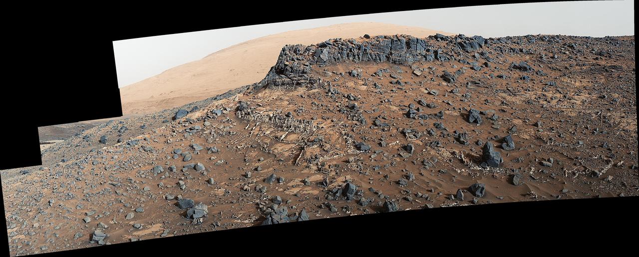
This 360-degree panorama was acquired by the Mast Camera (Mastcam) on NASA's Curiosity Mars rover as the rover neared features called "Murray Buttes" on lower Mount Sharp. The view combines more than 130 images taken on Aug. 5, 2016, during the afternoon of the mission's 1,421st sol, or Martian day, by Mastcam's left-eye camera. This date also was the fourth anniversary of Curiosity's landing. The dark, flat-topped mesa seen to the left of Curiosity's robotic arm is about 300 feet (about 90 meters) from the rover's position. It stands about 50 feet (about 15 meters) high. The horizontal ledge near the top of the mesa is about 200 feet (about 60 meters) across. An upper portion of Mount Sharp appears on the distant horizon to the left of this mesa. The relatively flat foreground is part of a geological layer called the Murray formation, which formed from lakebed mud deposits. The buttes and mesas rising above this surface are eroded remnants of ancient sandstone that originated when winds deposited sand after lower Mount Sharp had formed. Curiosity closely examined that layer -- the Stimson formation -- during the first half of 2016 while crossing a feature called "Naukluft Plateau" between two exposures of the Murray formation. The buttes and mesas of Murray Buttes are capped by material that is relatively resistant to erosion, just as is the case with many similarly shaped buttes and mesas on Earth. The informal naming honors Bruce Murray (1931-2013), a Caltech planetary scientist and director of NASA's Jet Propulsion Laboratory, Pasadena, California. The scene is presented with a color adjustment that approximates white balancing, to resemble how the rocks and sand would appear under daytime lighting conditions on Earth. http://photojournal.jpl.nasa.gov/catalog/PIA20765
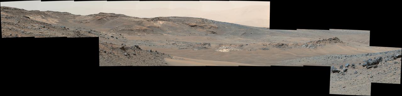
This 360-degree mosaic from the Mast Camera (Mastcam) on NASA's Curiosity Mars rover looks out over a portion of the Bagnold Dunes, which stretch for several miles. From early February to early April 2017, the rover examined four sites near linear dunes for comparison with what it found in late 2015 and early 2016 during its investigation of crescent-shaped dunes. The dark, rippled surface of a linear dune is visible at the center of the view and receding into the distance to the left. The bedrock of the Murray formation, made from sediments deposited in lakes billions of years ago, is in the foreground, along with some components of the rover. The location, called "Ogunquit Beach," is on the northwestern flank of lower Mount Sharp. Northwest is at both ends of this full-circle panorama; southeast is at the center, where a higher portion of Mount Sharp dominates the horizon. Among the questions this Martian dune campaign is addressing is how winds shape the dunes into different patterns. Others include whether Martian winds sort grains of sand in ways that affect the distribution of mineral compositions, which also would have implications for studies of Martian sandstones. The 115 individual images that were combined into this mosaic were acquired by the Mastcam's left-eye camera on March 24 and March 25, 2017, (PST) during the 1,647th Martian day, or sol, of Curiosity's work on Mars. This mosaic is white-balanced so that the colors of the colors of the rock and sand materials resemble how they would appear under daytime lighting conditions on Earth. The rover's position on Sol 1647 is shown at https://mars.nasa.gov/multimedia/images/2017/curiositys-traverse-map-through-sol-1646 as the location reached by a drive on Sol 1646. https://photojournal.jpl.nasa.gov/catalog/PIA11241
This view from the Mast Camera (Mastcam) on NASA's Curiosity Mars rover shows a dark sand dune in the middle distance. The rover's examination of dunes on the way toward higher layers of Mount Sharp will be the first in-place study of an active sand dune anywhere other than Earth. The scene combines several images taken on Sept. 25, 2015, during the 1,115th Martian day, or sol, of Curiosity's work on Mars. The images are from Mastcam's right-eye camera, which has a telephoto lens. The view is toward south-southwest. The dunes on Curiosity's route are part of a band of dunes called "Bagnold Dunes," along the northwestern edge of Mount Sharp. The informal naming recognizes British military engineer Ralph Bagnold (1896-1990), a pioneer in the study of how winds move sand particles of dunes on Earth. The dune field is evident as a dark band in orbital images of the area inside Gale Crater were Curiosity has been active since landing in 2012, such as a traverse map at PIA20162. Dunes are larger than wind-blown ripples of sand or dust that Curiosity and other rovers have visited previously. One dune that Curiosity will investigate in coming days is as tall as a two-story building and as broad as a football field. Ripples on the surface of these Martian dunes are larger than ripples on the surfaces of sand dunes on Earth. The scene is presented with a color adjustment that approximates white balancing, to resemble how the rocks and sand would appear under daytime lighting conditions on Earth. http://photojournal.jpl.nasa.gov/catalog/PIA19928