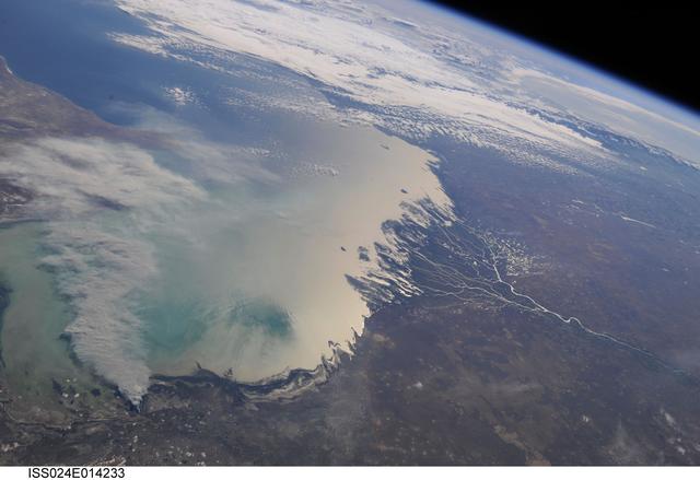
ISS024-E-014233 (11 Sept. 2010) --- A smoke plume near the northern Caspian Sea, Kazakhstan is featured in this image photographed by an Expedition 24 crew member on the International Space Station. This broad view of the north coast of the Caspian Sea shows a smoke plume (left) and two river deltas (bottom and lower right). The larger delta is that of the Volga River which appears prominently here in sunglint (light reflected off a water surface back towards the observer), and the smaller less prominent delta is that of the Ural River. Wide angle, oblique views ? taken looking outward at an angle, rather than straight down towards Earth ? such as this give an excellent impression of how crew members onboard the space station view Earth. For a sense of scale, the Caucasus Mts. (across the Caspian, top right) are approximately 1,100 kilometers to the southwest of the International Space Station?s nadir point location ? the point on Earth directly underneath the spacecraft ? at the time this image was taken. The smoke plume appears to be sourced in the dark-toned coastal marsh vegetation along the outer fringe of the Ural River delta, rather than in a city or at some oil storage facility. Although even small fires produce plumes that are long and bright and thus easily visible from space, the density of the smoke in this plume, and its 350-kilometer length across the entire north lobe of the Caspian Sea, suggest it was a significant fire. The smoke was thick enough nearer the source to cast shadows on the sea surface below. Lines mark three separate pulses of smoke, the most recent, nearest the source, extending directly south away from the coastline (lower left). With time, plumes become progressively more diffuse. The oldest pulse appears to be the thinnest, casting no obvious shadows (center left).

ISS028-E-020276 (2 Aug. 2011) --- This photograph of polar mesospheric clouds was acquired at an altitude of just over 202 nautical miles (about 322 kilometers) in the evening hours (03:19:54 Greenwich Mean Time) on Aug. 2, 2011, as the International Space Station was passing over the English Channel. The nadir coordinates of the station were 49.1 degrees north latitude and 5.5 degrees west longitude. Polar mesospheric clouds (also known as noctilucent, or ?night-shining? clouds) are transient, upper atmospheric phenomena that are usually observed in the summer months at high latitudes (greater than 50 degrees) of both the Northern and Southern Hemispheres. They appear bright and cloudlike while in deep twilight. They are illuminated by sunlight when the lower layers of the atmosphere are in the darkness of Earth?s shadow. The horizon of Earth appears at the bottom of the image, with some layers of the lower atmosphere already illuminated by the rising sun. The higher, bluish-colored clouds look much like wispy cirrus clouds, which can be found as high as 60,000 feet (18 kilometers) in the atmosphere. However noctilucent clouds, as seen here, are observed in the mesosphere at altitudes of 250,000 to 280,000 feet (about 76 to 85 kilometers). Astronaut observations of polar mesospheric clouds over northern Europe in the summer are not uncommon.
ISS034-E-48455 (14 Feb. 2013) --- Looking out at Earth?s surface from the International Space Station (ISS), astronauts and cosmonauts frequently observe sunglint highlighting both ocean and inland water surfaces. The Atlantic Ocean, including Cape Cod Bay and Buzzards Bay, along the coastlines of Massachusetts and Rhode Island, has a burnished, mirror-like appearance in this image. This is due to sunlight reflected off the water surface back towards the station crew member who took the photo. The peak reflection point is towards the right side of the image, lending the waters of Long Island Sound and the upper Massachusetts coastline an even brighter appearance. Sunglint also illuminates the surface waters of Chesapeake Bay, located over 400 kilometers (250 miles) to the southwest of the tip of Long Island. This suggests that the Sun was low on the horizon due to the observed extent of the sunglint effect. The time of image acquisition, approximately 4:26 p.m. Eastern Standard Time, was about one hour before local sunset. There is little in this image to indicate that the region was still recovering from a major winter storm that dropped almost one meter (three feet) of snow over much of the northeastern USA less than a week earlier. The high viewing angle from the space station also allows Earth?s curvature, or limb, to be seen; blue atmospheric layers gradually fade into the darkness of space across the top part of the image. Low clouds near Cape Cod, Long Island, and further down the Atlantic coastline cast shadows over the water surfaces, reducing the sunglint in some areas.
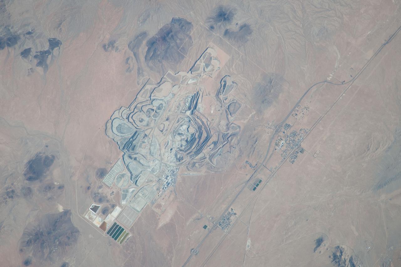
ISS037-E-022990 (30 Oct. 2013) --- This detailed image, photographed by an Expedition 37 crew member on the International Space Station, features the former US Borax mine located to the northwest of Boron, California. The mine, currently owned by the Rio Tinto Group, is the largest open-pit mine in California (covering approximately 54 square kilometers) and is among the largest borate mines in the world. Borates, chemical compounds that include the element boron (B), are important both as providers of an essential plant micronutrient, for metallurgical applications, and as components of specialized types of glass, anticorrosive coatings, fire retardants, and detergents (among other uses). Borate minerals such as borax, kernite, and ulexite are found in deposits at the Rio Tinto borax mine. The geologic setting is a structural, nonmarine basin ? a permanent shallow lake ? fed by thermal springs rich in sodium and boron that existed approximately 16 million years ago, according to scientists. The first mining claim in the area was filed in 1913, following discovery of boron-bearing nodules during well drilling. Much of the mine workings were underground until 1957, when US Borax changed to open-pit mining. The open pit is clearly visible at center; concentric benches along the pit wall are accentuated by shadows and mark successive levels of material extraction. Mine tailings are visible as stacked terraces along the northern boundary of the mine. Ore processing facilities occupy a relatively small percentage of the mine area, and are located directly to the west of the open pit. The Rio Tinto mine is one of the Earth?s richest borate deposits; together with mines in Argentina, they produce almost 40 percent of the world?s supply of industrial borate minerals.
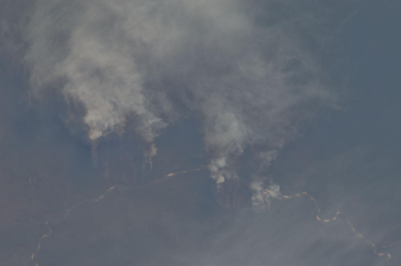
ISS029-E-008032 (17 Sept. 2011) --- Fires along the Rio Xingu, Brazil are featured in this image photographed by an Expedition 29 crew member on the International Space Station. The rain forest of South America, also known as ?Amazonia??the largest such forest on Earth?has been undergoing a continual and accelerated land use conversion process into farmlands (including pasture for livestock) since the early 1960s. This process has typically been achieved by clearing of the forest using fire ? ?slash and burn? ? followed by planting of crops. The generally infertile soils of the region make sustainable farming difficult; this drives more forest conversion into new farmland. The area of clearing can be considerable, and as the deforested regions are easily identifiable and measurable from space the rate of deforestation is likewise easy to track. This detailed photograph illustrates slash-and-burn forest clearing along the Xingu River (Rio) in the northeast of the state of Matto Grasso, Brazil. The perspective of this image allows for a striking visualization of both the horizontal position and extent of the fire lines next to the river, as well as providing a sense of the vertical structure of the smoke plumes due to the viewing angle and shadowing. Light colored areas within the river channel are sand bars, which show that the river is in its annual low-flow/ low water stage. For a sense of scale, the Xingu River channel within the view is approximately 63 kilometers long. Rivers in Amazonia are its natural highways, which may explain why the burning is occurring right next to the Xingu River, one of Amazonia?s largest. In recent years, preservation has gained traction in the region as a result of such considerations as new valuation of the ecosystem services provided by the forest, concerns about the impact of widespread burning on global climate change, and greater sensitivity to the ethnic and biological heritage of Amazonia.
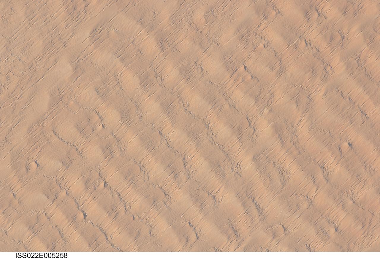
ISS022-E-005258 (1 Dec. 2009) --- This detailed hand-held digital camera?s image recorded from the International Space Station highlights sand dunes in the Fachi-Bilma erg, or sand sea, which is part of the central eastern Tenere Desert. The Tenere occupies much of southeastern Niger and is considered to be part of the larger Sahara Desert that stretches across northern Africa. Much of the Sahara is comprised of ergs ? with an area of approximately 150,000 square kilometers, the Fachi-Bilma is one of the larger sand seas. Two major types of dunes are visible in the image. Large, roughly north-south oriented transverse dunes fill the image frame. This type of dune tends to form at roughly right angles to the dominant northeasterly winds. The dune crests are marked in this image by darker, steeper sand accumulations that cast shadows. The lighter-toned zones between are lower interdune ?flats?. The large dunes appear to be highly symmetrical with regard to their crests. This suggests that the crest sediments are coarser, preventing the formation of a steeper slip face on the downwind side of the dune by wind-driven motion of similarly-sized sand grains. According to NASA scientists, this particular form of transverse dune is known as a zibar, and is thought to form by winnowing of smaller sand grains by the wind, leaving the coarser grains to form dune crests. A second set of thin linear dunes oriented at roughly right angles to the zibar dunes appears to be formed on the larger landforms and is therefore a younger landscape feature. These dunes appear to be forming from finer grains in the same wind field as the larger zibars. The image was taken with digital still camera fitted with a 400 mm lens, and is provided by the ISS Crew Earth Observations experiment and Image Science & Analysis Laboratory, Johnson Space Center.
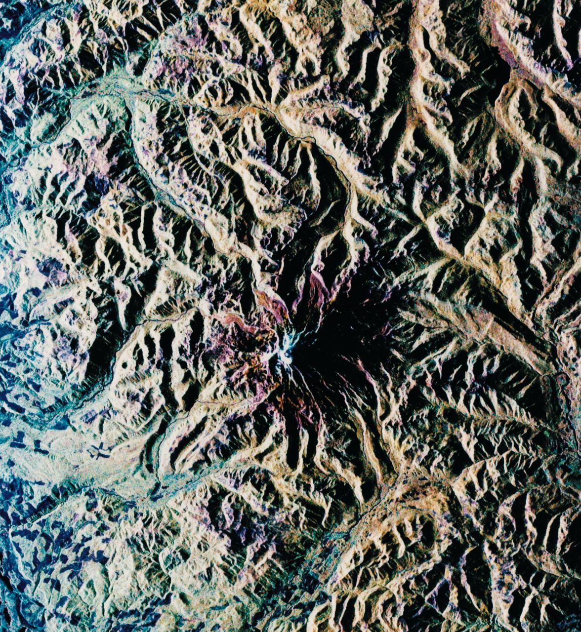
STS068-S-052 (3 October 1994) --- This is a radar image of Mount Rainier in Washington state. The volcano last erupted about 150 years ago and numerous large floods and debris flows have originated on its slopes during the last century. Today the volcano is heavily mantled with glaciers and snow fields. More than 100,000 people live on young volcanic mud flows less than 10,000 years old and, are within the range of future, devastating mud slides. This image was acquired by the Spaceborne Imaging Radar-C/X-Band Synthetic Aperture Radar (SIR-C/X-SAR) aboard the Space Shuttle Endeavour on its 20th orbit on October 1, 1994. The area shown in the image is approximately 59 by 60 kilometers (36.5 by 37 miles). North is toward the top left of the image, which was composed by assigning red and green colors to the L-Band, horizontally transmitted and vertically, and the L-Band, horizontally transmitted and vertically received. Blue indicates the C-Band, horizontally transmitted and vertically received. In addition to highlighting topographic slopes facing the Space Shuttle, SIR-C records rugged areas as brighter and smooth areas as darker. The scene was illuminated by the Shuttle's radar from the northwest so that northwest-facing slopes are brighter and southeast-facing slopes are dark. Forested regions are pale green in color, clear cuts and bare ground are bluish or purple; ice is dark green and white. The round cone at the center of the image is the 14,435 feet (4,399 meters) active volcano, Mount Rainier. On the lower slopes is a zone of rock ridges and rubble (purple to reddish) above coniferous forests (in yellow/green). The western boundary of Mount Rainier National Park is seen as a transition from protected, old-growth forest to heavily logged private land, a mosaic of recent clear cuts (bright purple/blue) and partially re-grown timber plantations (pale blue). The prominent river seen curving away from the mountain at the top of the image (to the northwest) is the White River, and the river leaving the mountain at the bottom right of the image (south) is the Nisqually River, which flows out of the Nisqually glacier on the mountain. The river leaving to the left of the mountain is the Carbon River, leading west and north toward heavily populated regions near Tacoma. The dark patch at the top right of the image is Bumping Lake. Other dark areas seen to the right of ridges throughout the image are radar shadow zones. Radar images can be used to study the volcanic structure and the surrounding regions with linear rock boundaries and faults. In addition, the recovery of forested lands from natural disasters and the success of re-forestation programs can also be monitored. Ultimately this data may be used to study the advance and retreat of glaciers and other forces of global change. Spaceborne Imaging Radar-C/X-Band Synthetic Aperture Radar (SIR-C/X-SAR) is part of NASA's Mission to Planet Earth. (P-44703)