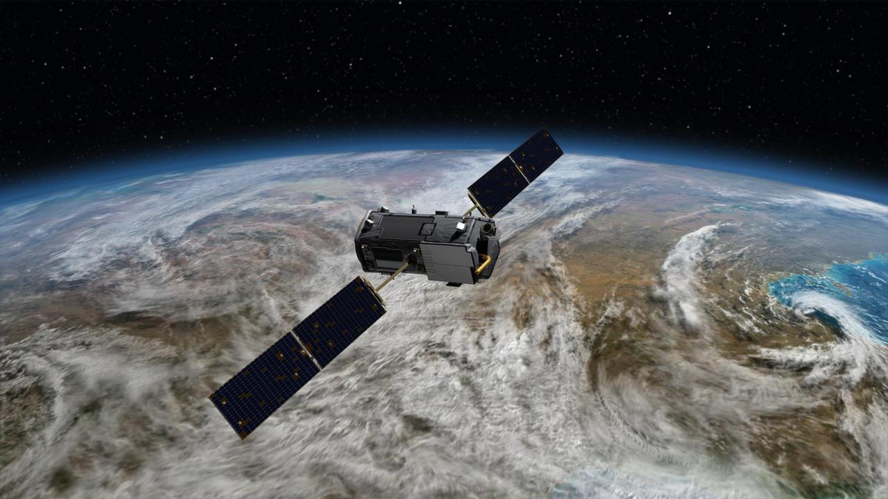
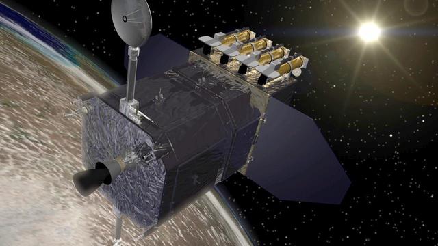
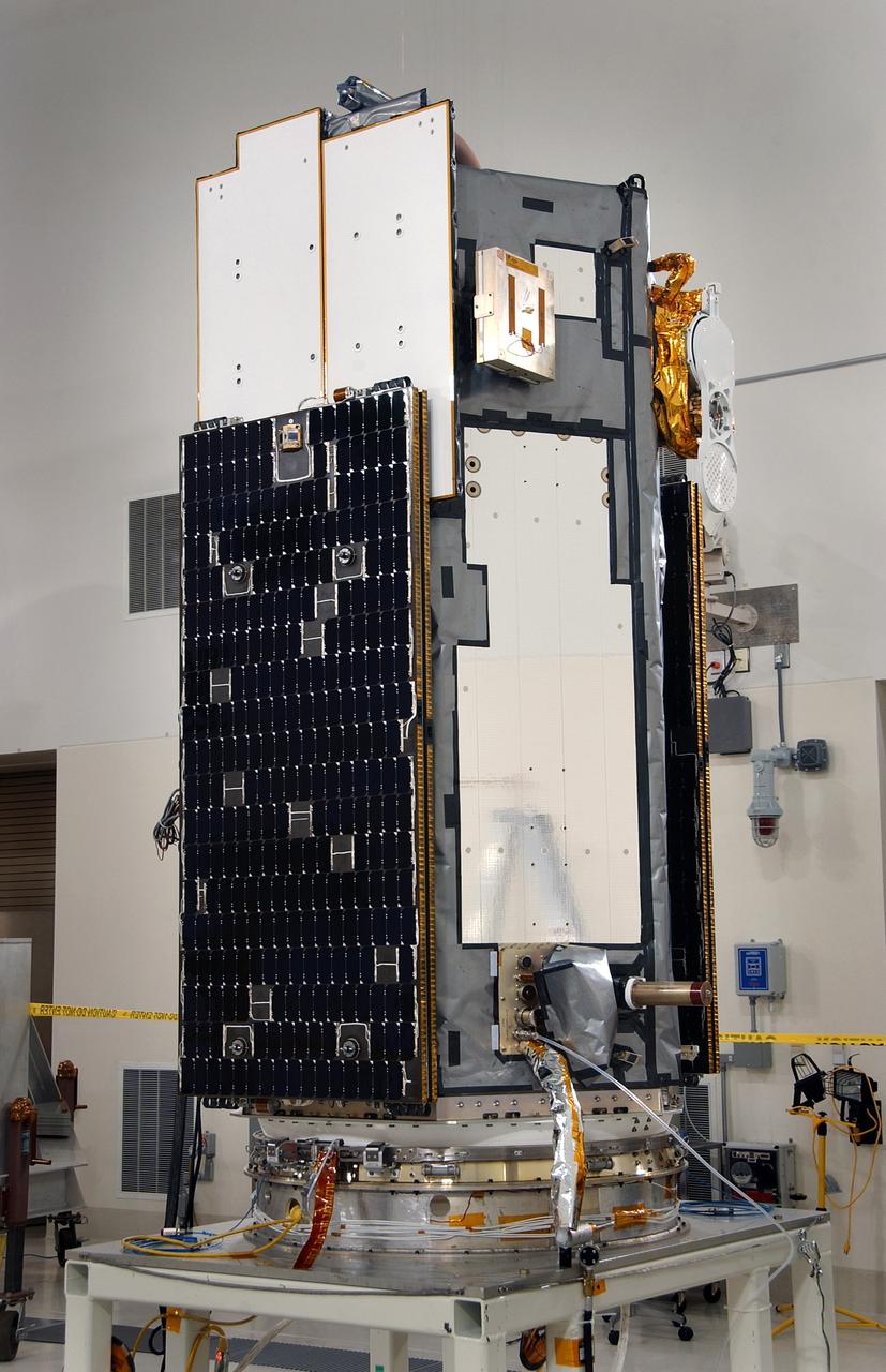
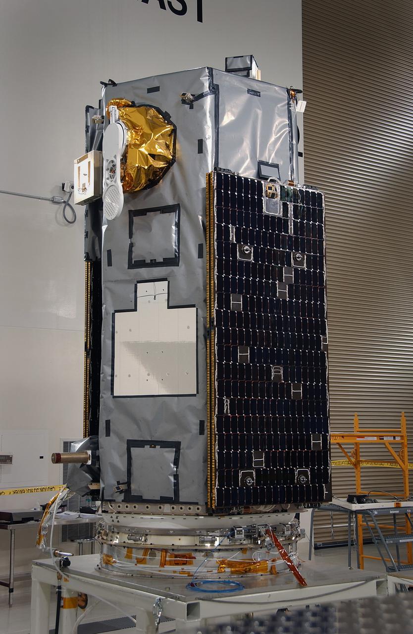
Artist rendering of NASA Orbiting Carbon Observatory OCO-2, one of five new NASA Earth science missions set to launch in 2014, and one of three managed by JPL.
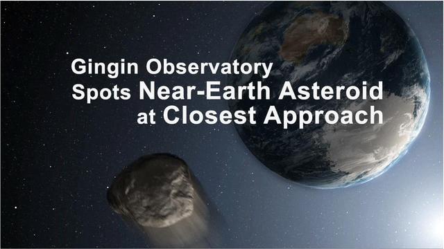
This frame from a movie shows the asteroid 2012 DA14 flying safely by Earth, as seen by the Gingin Observatory in Australia around the time of its closest approach, 11:24:42 a.m. PST 2:24:42 p. The animation is available in the Planetary Photojournal.
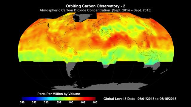
Global average carbon dioxide concentrations as seen by NASA’s Orbiting Carbon Observatory-2 mission, June 1-15, 2015. OCO-2 measures carbon dioxide from the top of Earth's atmosphere to its surface. Higher carbon dioxide concentrations are in red, with lower concentrations in yellows and greens. Scientists poring over data from OCO-2 mission are seeing patterns emerge as they seek answers to questions about atmospheric carbon dioxide. Among the most striking features visible in the first year of OCO-2 data is the increase in carbon dioxide in the northern hemisphere during winter, when trees are not removing carbon dioxide, followed by its decrease in spring, as trees start to grow and remove carbon dioxide from the atmosphere. http://photojournal.jpl.nasa.gov/catalog/PIA20039

NASA's ARIA team, in collaboration with the Earth Observatory of Singapore, used satellite data to map the extent of likely damage following a massive explosion in Beirut. Dark red pixels represent the most severe damage. Areas in orange are moderately damaged, and areas in yellow are likely to have sustained somewhat less damage. Each colored pixel represents an area of 30 meters (33 yards). https://photojournal.jpl.nasa.gov/catalog/PIA23692
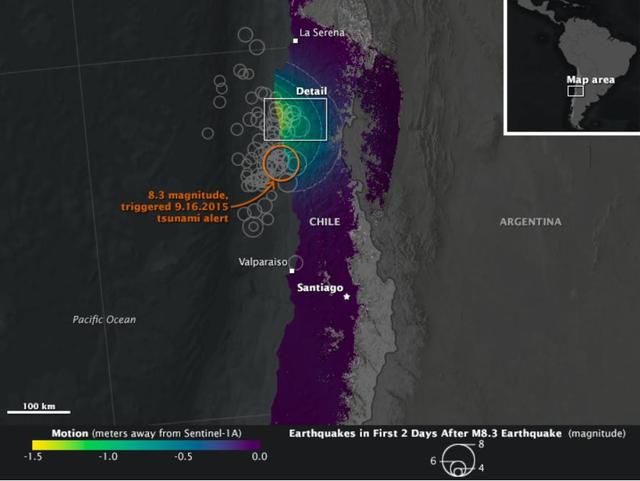
On Sept. 16, 2015, a magnitude 8.3 earthquake struck near the coast of central Chile along the boundary of the Nazca and South American tectonic plates. Dubbed the Illapel earthquake, the shaking lasted at least three minutes and propelled a 15-foot (4.5-meter) tsunami that washed into Coquimbo and other coastal areas. Smaller tsunami waves raced across the Pacific and showed up on the shores of Hawaii and other islands. The earthquake and tsunami caused substantial damage in several Chilean coastal towns, and at least 13 deaths have been reported. Demanding building codes and extensive disaster preparedness helped to limit the loss of life and property. The maps above, known as interferograms, show how the quake moved the ground, as observed by the Copernicus Sentinel-1A satellite (operated by the European Space Agency) and reported by ground stations to the U.S. Geological Survey. Sentinel-1A carries a synthetic aperture radar (SAR) instrument, which beams radio signals toward the ground and measures the reflections to determine the distance between the ground and the satellite. By comparing measurements made on Aug. 24 and Sept. 17, Cunren Liang, Eric Fielding, and other researchers from NASA's Jet Propulsion Laboratory were able to determine how the land surface shifted during and after the earthquake. Interferograms can be used to estimate where the fault moved deep in Earth and which areas have increased stress and higher likelihood of future earthquakes. The details can also provide important information to better understand the earthquake process. On both the close-up and the broad-view maps, the amount of land motion is represented in shades from yellow to purple. Areas where the ground shifted the most (vertically, horizontally, or both) are represented in yellow, while areas with little change are represented in purple. Circles show the location of earthquakes and aftershocks in the two days after the initial 8.3 earthquake, as reported by the USGS National Earthquake Information Center. Larger quakes are represented by larger circles. The base map layer uses a digital elevation model and a bathymetry map to show the contours of the land surface and seafloor. The interferograms above show that land moved as much as 1.4 meters toward to satellite (generally in the vertical direction) near the coast, and early estimates of the horizontal motion suggest it was as much as 2 meters. While SAR can see through clouds and the dark of night, it cannot see much through water. It is likely that much of the ground deformation from the earthquake occurred underwater, which explains the formation of the tsunami and the location of many aftershocks. http://photojournal.jpl.nasa.gov/catalog/PIA20002
The Solar Dynamics Observatory SDO spacecraft, shown above the Earth as it faces toward the Sun. SDO is designed to study the influence of the Sun on the Earth and the inner solar system by studying the solar atmosphere. http://photojournal.jpl.nasa.gov/catalog/PIA18169

Mt. Dana and Dana Plateau in the Tuolumne River Basin within Yosemite National Park, Calif., as seen out the window of a Twin Otter aircraft carrying NASA Airborne Snow Observatory on April 3, 2013.
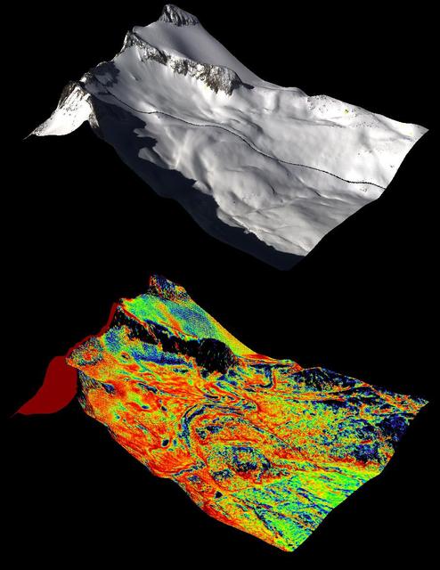
A natural color image of Mt. Lyell, the highest point in the Tuolumne River Basin top image is compared with a three-dimensional color composite image of Mt. Lyell from NASA Airborne Snow Observatory depicting snow depth bottom image.

Spatial distribution of snow water equivalent across the Tuolumne River Basin from April 10 to June 1, 2013 as measured by NASA Airborne Snow Observatory.

NASA Airborne Snow Observatory measurements of snow water equivalent top image and snow albedo, or reflectivity bottom image for the Tuolumne River Basin in California Sierra Nevada on April 21, 2013.
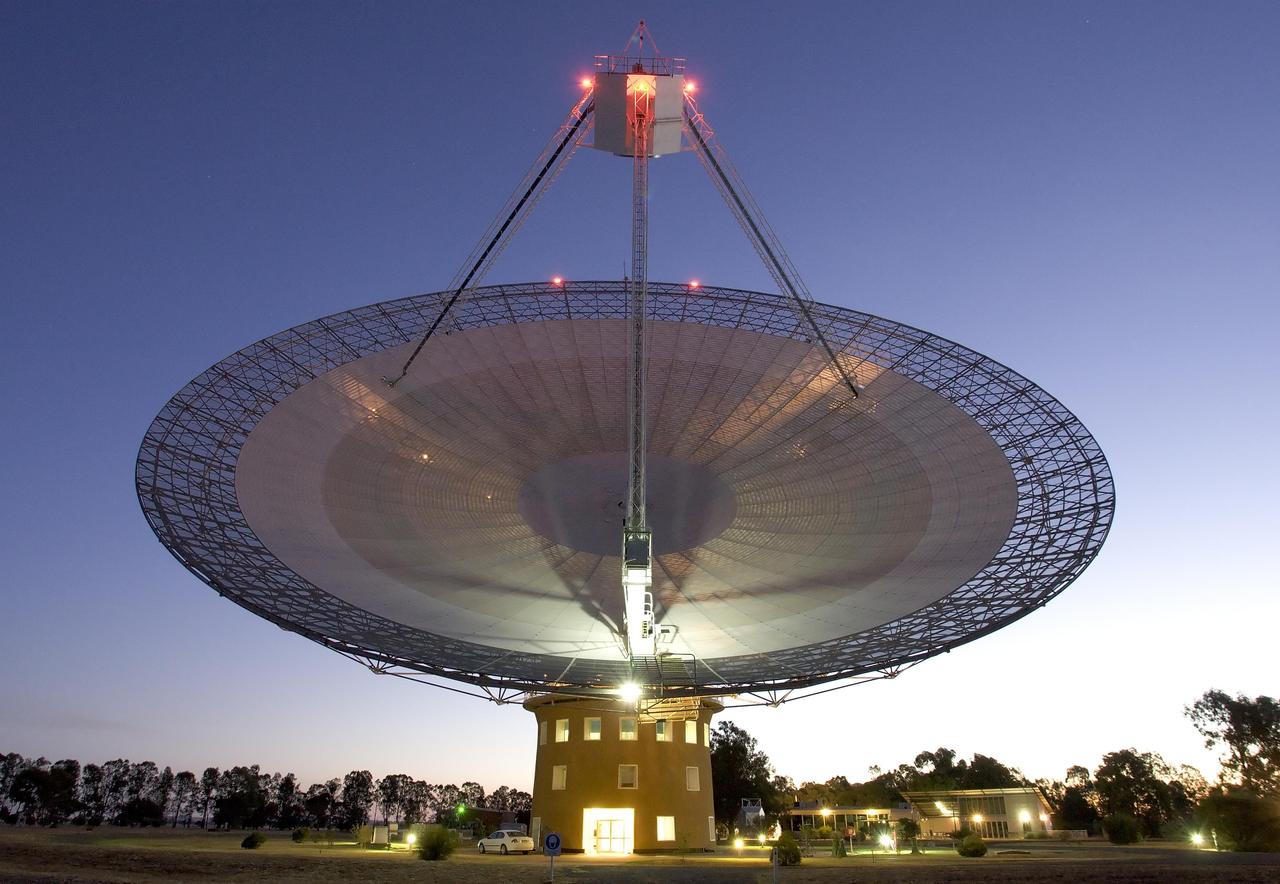
This image shows the Parkes telescope in Australia, part of the Commonwealth Scientific and Industrial Research Organization. Researchers used the telescope to detect the first population of radio bursts known to originate from beyond our galaxy.
NASA Airborne Snow Observatory is two instruments combined that provides information on every patch of snow, including how deep it is and how fast it melting. This is a frame from an animation.
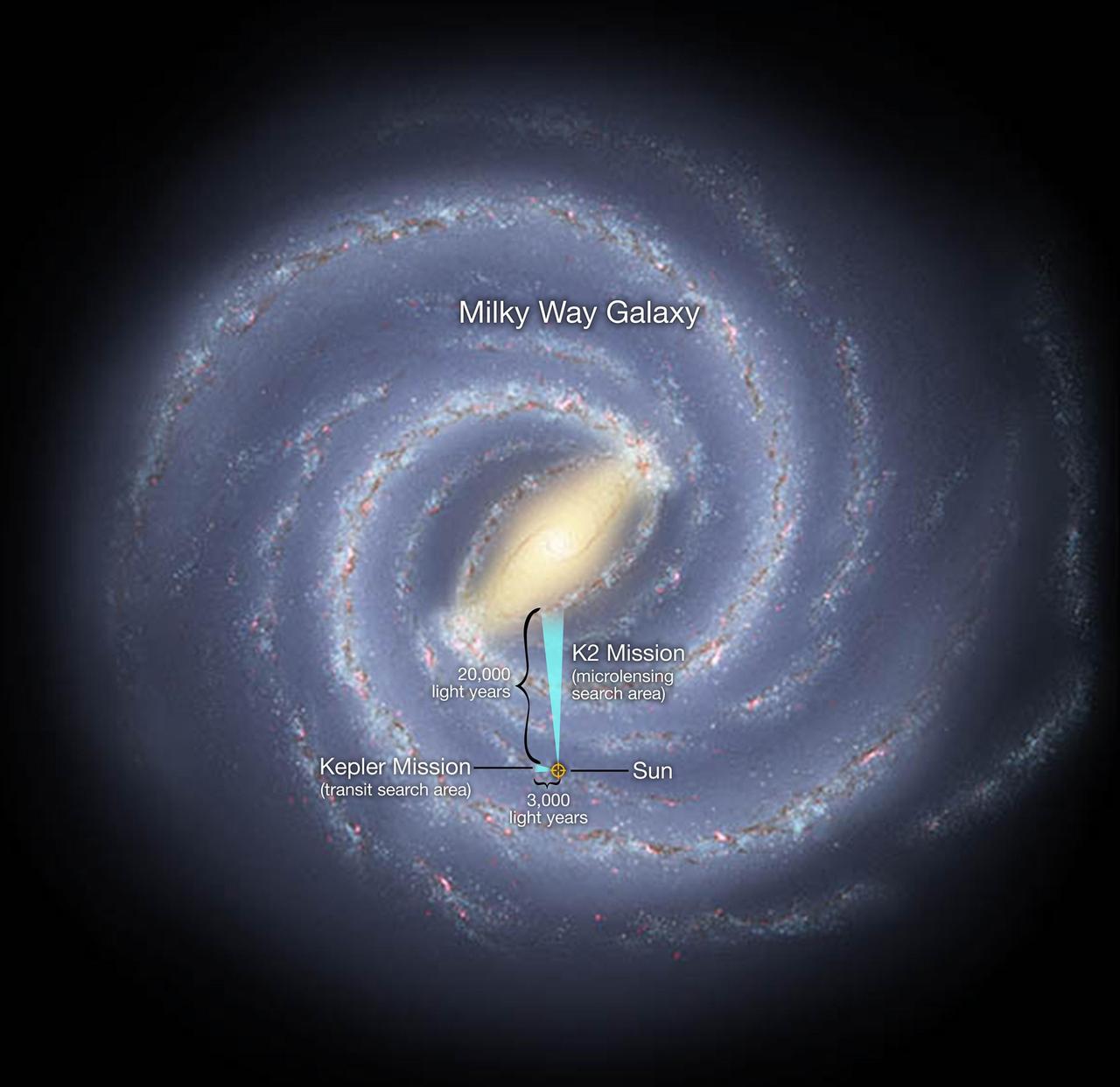
In a global experiment in exoplanet observation, the K2 mission and Earth-based observatories on six continents will survey millions of stars toward the center of our Milky Way galaxy.
ESA Herschel Space Observatory captured asteroid Apophis in its field of view during the approach to Earth on Jan. 5 and 6, 2013.
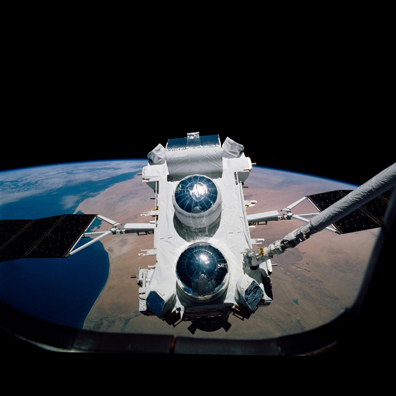
Backdropped against the Earth's surface, the Gamma Ray Observatory (GRO) with its solar array (SA) panels deployed is grappled by the remote manipulator system (RMS) during STS-37 systems checkout. GRO's four complement instruments are visible: the Energetic Gamma Ray Experiment Telescope (EGRET) (at the bottom); the Imaging Compton Telescope (COMPTEL) (center); the Oriented Scintillation Spectrometer Experiment (OSSE) (top); and Burst and Transient Source Experiment (BATSE) (on four corners). The view was taken by STS-37 crew through an aft flight deck overhead window.

Artist rendering of NASA Orbiting Carbon Observatory OCO-2, one of five new NASA Earth science missions set to launch in 2014, and one of three managed by JPL.
This image is a blinking of two 14-minute exposures of NASA Dawn spacecraft from 600,000 miles from Earth. Bill Dillon, a regular advanced user of Sierra Stars Observatory.

Using NASA Herschel Space Observatory, astronomers have discovered that comet Hartley 2 possesses a ratio of heavy water to light, or normal, water that matches what found in Earth oceans.

This most recent artist rendering shows NASA Orbiting Carbon Observatory OCO-2, one of five new NASA Earth science missions set to launch in 2014, and one of three managed by the Jet Propulsion Laboratory JPL.

This image from ESA Herschel Space Observatory shows of a portion of the Rosette nebula, a stellar nursery about 5,000 light-years from Earth in the Monoceros, or Unicorn, constellation.
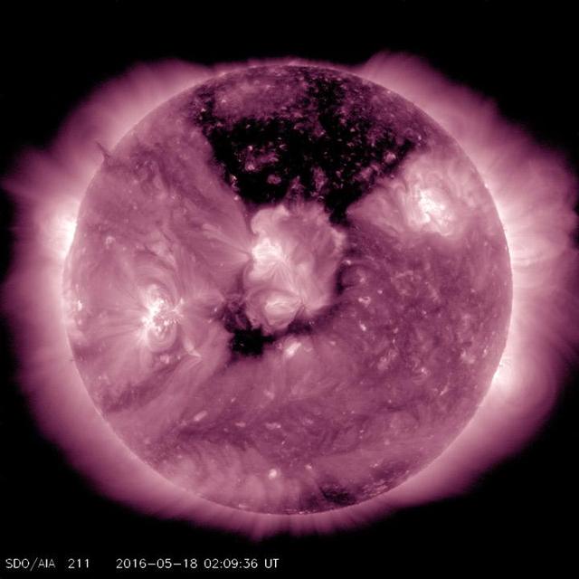
A substantial coronal hole had rotated so that it temporarily faced right towards Earth May, 17-19, 2016. This coronal hole area is the dark area at the top center of this image from NASA Solar Dynamics Observatory.
This set of images from the La Sagra Sky Survey, operated by the Astronomical Observatory of Mallorca in Spain, shows the passage of asteroid 2012 DA14 shortly after its closest, and safe, approach to Earth.
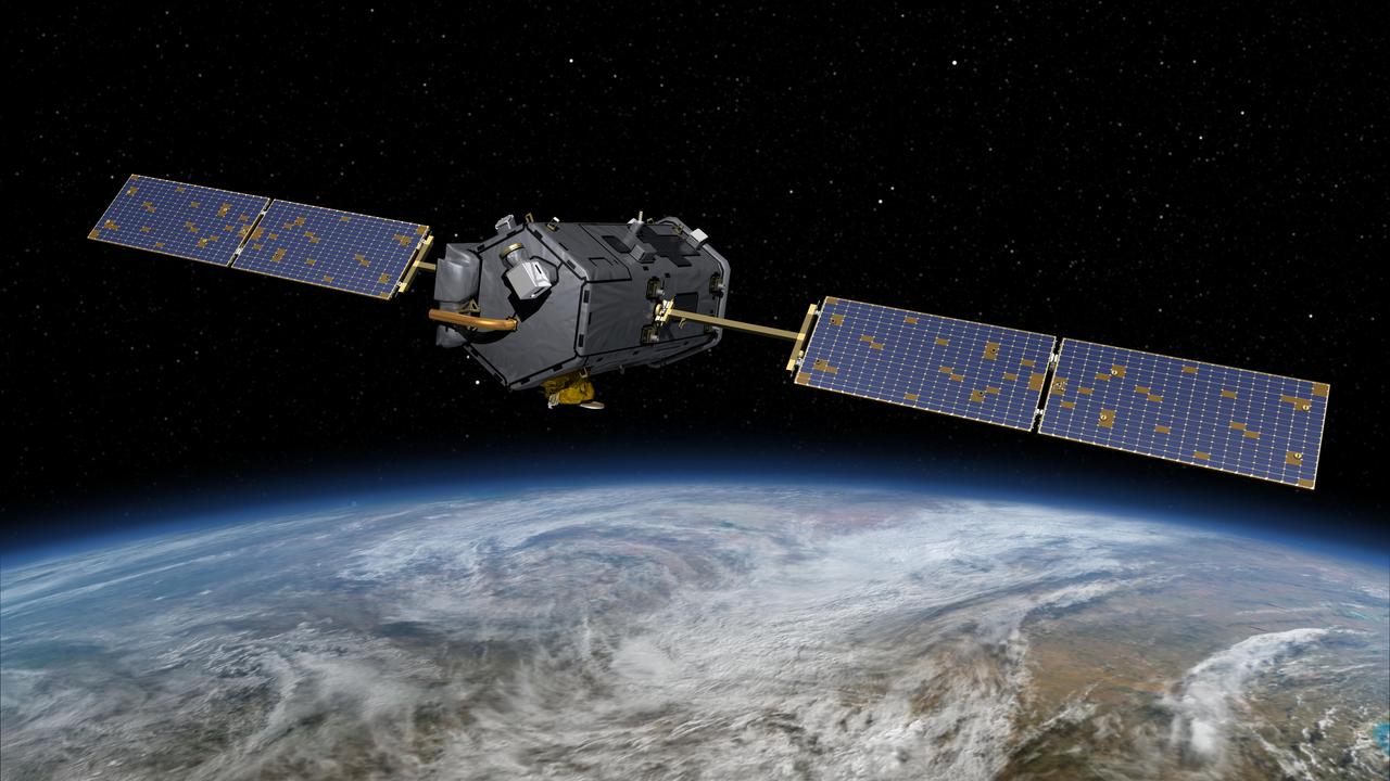
This most recent artist rendering shows NASA Orbiting Carbon Observatory OCO-2, one of five new NASA Earth science missions set to launch in 2014, and one of three managed by the Jet Propulsion Laboratory JPL.
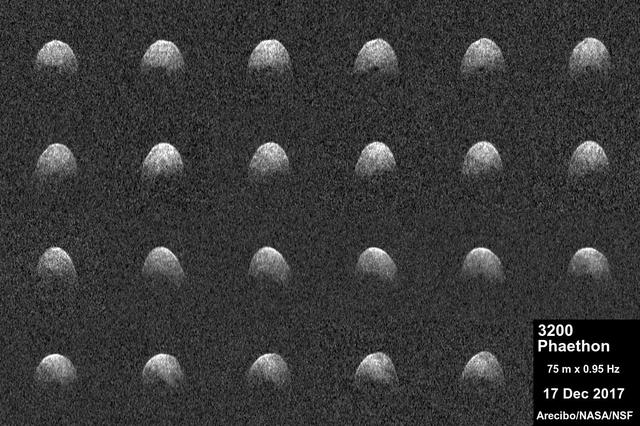
These radar images of near-Earth asteroid 3200 Phaethon were generated by astronomers at the National Science Foundation's Arecibo Observatory on Dec. 17, 2017. Observations of Phaethon were conducted at Arecibo from Dec.15 through 19, 2017. At time of closest approach on Dec. 16 at 3 p.m. PST (6 p.m. EST, 11 p.m. UTC) the asteroid was about 6.4 million miles (10.3 million kilometers) away, or about 27 times the distance from Earth to the moon. The encounter is the closest the object will come to Earth until 2093. An animation is available at https://photojournal.jpl.nasa.gov/catalog/PIA22185
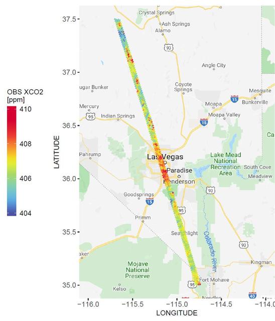
A spatial map of the amount of carbon dioxide (CO2) present in columns of the atmosphere below NASA's Orbiting Carbon Observatory-2 (OCO-2) satellite as it flew over Las Vegas on Feb. 8, 2018. Warmer colors over the city center indicate higher amounts of carbon dioxide. https://photojournal.jpl.nasa.gov/catalog/PIA23781
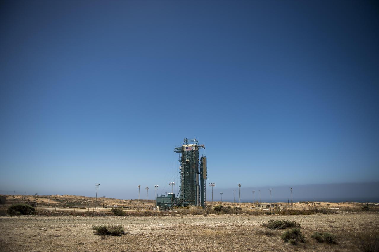
The launch gantry, surrounding the United Launch Alliance Delta II rocket with the Orbiting Carbon Observatory-2 OCO-2 satellite onboard, is seen at Space Launch Complex 2, Sunday, June 29, 2014, Vandenberg Air Force Base, Calif.
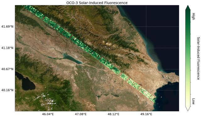
Image shows OCO-3's first preliminary solar-induced fluorescence (SIF) measurements over western Asia. Solar-induced fluorescence is the glow plants emit from photosynthesis — the process of plant growth that includes the capture of carbon from the atmosphere. Areas with lower photosynthesis activity are in shown in light green; areas with higher photosynthesis activity are shown in dark green. As expected, there is significant contrast in plant activity from areas of low vegetation near the Caspian Sea to areas of more dense vegetation like the forests and farms north and east of the Mingachevir Reservoir (near the center of the image). The mission team expects to complete OCO-3's In-orbit checkout phase — the period where they ensure all instruments and components are working and calibrated correctly — in August 2019. They are scheduled to release official CO2 and solar-induced fluorescence data to the science community a year later; however, the data will likely be available sooner given the quality of the measurements that OCO-3 is already making. https://photojournal.jpl.nasa.gov/catalog/PIA23353
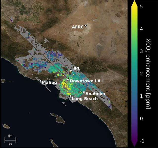
This animation shows the accumulation of five adjoining swaths of data over the Los Angeles metropolitan area that when combined, create a map of carbon dioxide (CO2) concentrations that covers about 50 square miles (80 square kilometers). Researchers have used the data, collected by NASA's Orbiting Carbon Observatory 3 (OCO-3) instrument aboard the space station, to create one of the most accurate maps ever made from space of the human influence on CO2 abundances in the L.A. Basin Each pixel is about 1.3 miles (2.2 kilometers); the color indicates how much higher the concentration of CO2 is in that spot than in clean desert air north of the city (measured at NASA's Armstrong Research Center, upper right). The highest CO2 readings, in yellow on the map, are on the west side of downtown L.A. – a densely populated area with congested freeways and CO2-emitting industries. Yellow indicates atmospheric CO2 elevated by five or more molecules out of every million molecules of air, or five parts per million. That's equivalent to the amount that global atmospheric CO2 is rising globally on average every two years Most of the increasing CO2 in the global atmosphere comes from humans burning fossil fuels for energy, and 70% of that comes from cities. Los Angeles has set goals for cutting its carbon emissions. This type of data can help decisionmakers choose the most effective policies to reach those goals and to measure the effectiveness of new regulations. Data from ground level provides critical local measurements, but satellite data is equally necessary because it covers a wider area and also measure CO2 throughout the entire depth of the atmosphere. Animation available at https://photojournal.jpl.nasa.gov/catalog/PIA24523
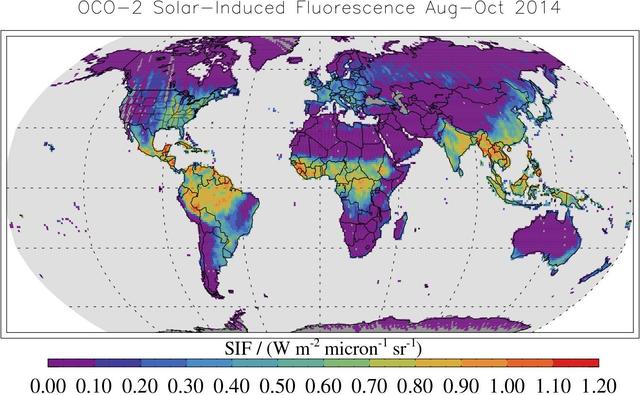
This map shows solar-induced fluorescence, a plant process that occurs during photosynthesis, from Aug. through Oct. 2014 as measured by NASA Orbiting Carbon Observatory-2.
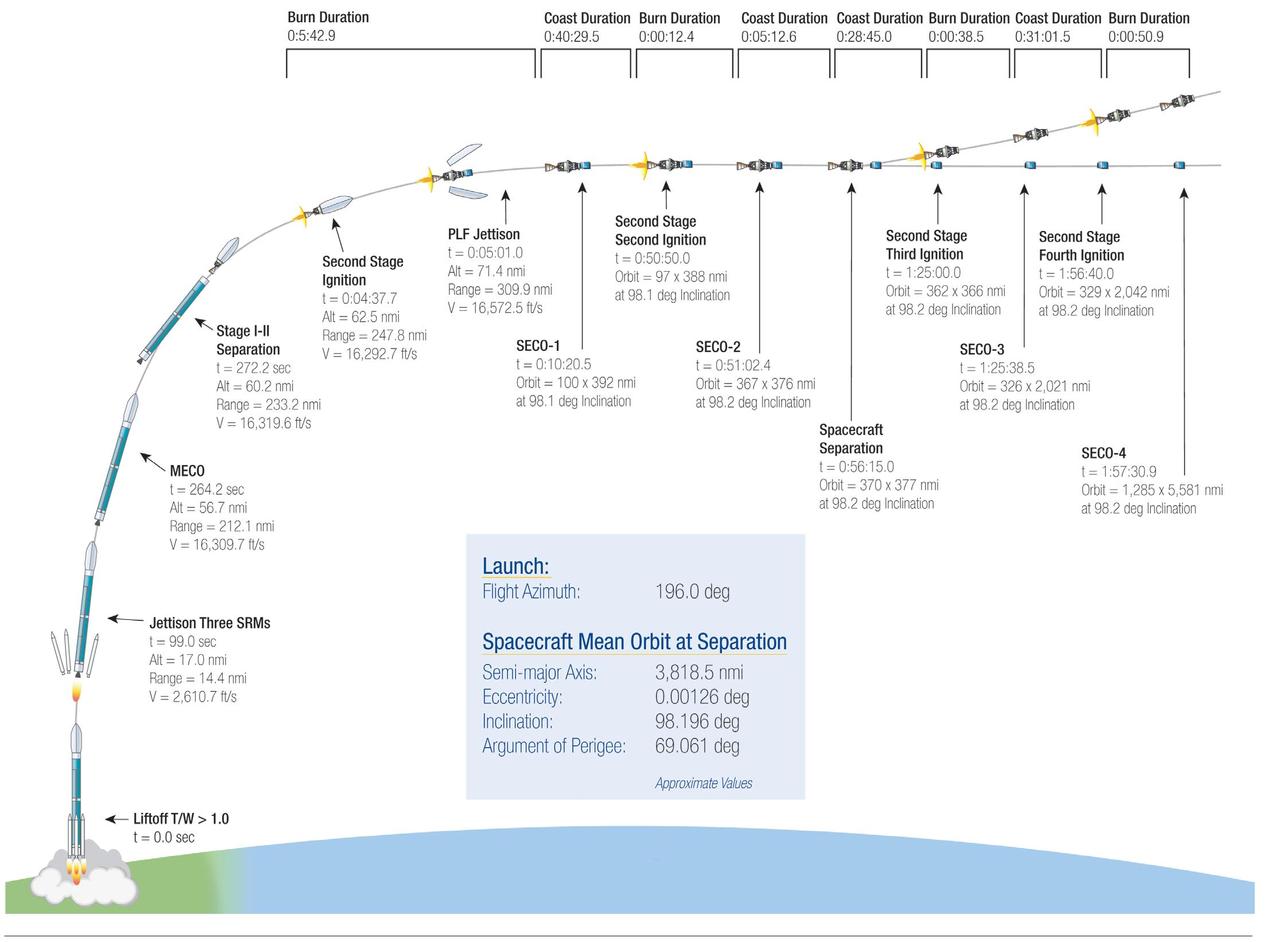
This illustration highlights key events in the launch of NASA Orbiting Carbon Observatory-2, beginning with its liftoff from Vandenberg Air Force Base in central California.
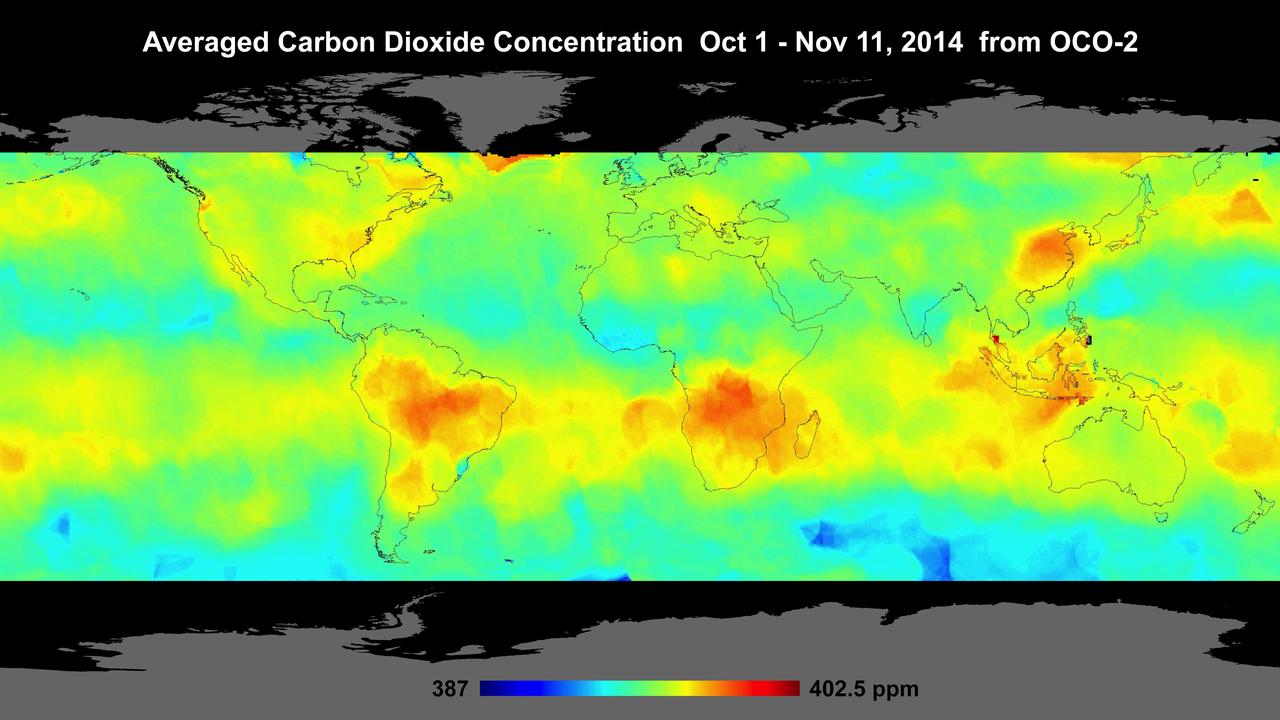
Global atmospheric carbon dioxide concentrations from Oct. 1 through Nov. 11, as recorded by NASA Orbiting Carbon Observatory-2.
This image shows CO2 over the United States during OCO-3's first few days of science data collection. These initial measurements are consistent with measurements taken by OCO-3's older sibling, OCO-2, over the same area — meaning that even though OCO-3's instrument calibration is not yet complete, it is right on track to continue its (currently still operational) predecessor's data record. The mission team expects to complete OCO-3's in-orbit checkout phase — the period where they ensure all instruments and components are working and calibrated correctly — in August 2019. They are scheduled to release official CO2 and solar-induced fluorescence data to the science community a year later; however, this data will likely be available sooner given the quality of the measurements that OCO-3 is already making. https://photojournal.jpl.nasa.gov/catalog/PIA23352
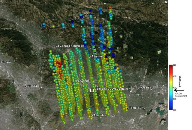
This image shows NASA OCO-2 measurements of carbon dioxide levels over Pasadena and the northern Los Angeles basin on Sept. 5, 2014. Each colored dot represents a single measurement of the greenhouse gas made during an overflight of the area.
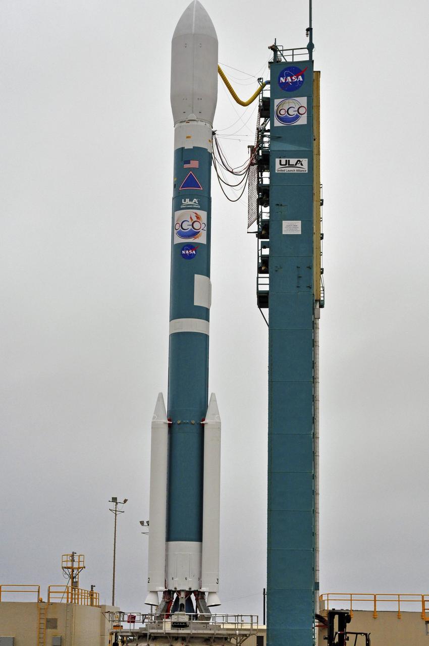
NASA Orbiting Carbon Observatory-2, perched atop a United Launch Alliance Delta II rocket, awaits launch at the Vandenberg Air Force Base in central California.
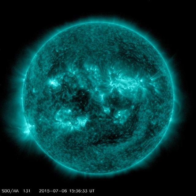
An eruption from the surface of the sun is conspicuous in the lower left portion of this July 6, 2015, image from NASA's Earth-orbiting Solar Dynamics Observatory (SDO). It originates from a location on the surface where NASA's Curiosity Mars rover had been tracking a sunspot in late June and early July. This image was taken by the Atmosphere Imaging Assembly on SDO using the instrument's 131-Angstrom wavelength channel, which is sensitive to hot solar flares. The sun completes a rotation about once a month -- faster near its equator than near its poles. This summer, Mars has a view of the opposite side of the sun from what's facing Earth. Images from Curiosity tracking a southern-hemisphere sunspot until it rotated out of view during the July 4 weekend are in an animation at PIA19801. This location on the sun rotated into position to be seen from Earth a few days later. The eruption visible in this image was linked to a coronal mass ejection observed by SDO and NASA's Solar and Heliospheric Observatory. The coronal mass ejection affected interplanetary space weather, as shown at http://go.nasa.gov/1JSXLF3. http://photojournal.jpl.nasa.gov/catalog/PIA19680
NASA's Solar Dynamics Observatory (SDO) saw both the Moon (upper right) and the Earth (upper left) partially block the sun (Sept. 1, 2016 at 7:33 UT). Just before this image was taken, the Earth totally blocked the sun for a while. SDO orbits 22,000 miles above the Earth in a highly elliptical orbit that sometimes puts the Moon or Earth in front of the sun. The sun image was taken in a wavelength of extreme ultraviolet light. Only once before have both been there at the same time. Note that the edge of the moon is quite crisp because it has no atmosphere. Movies are available at the Photojournal. http://photojournal.jpl.nasa.gov/catalog/PIA21028
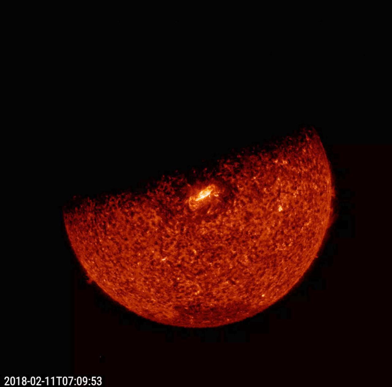
On the 8th anniversary of its launch in 2010, NASA's Solar Dynamics Observatory (SDO) captured a total solar eclipse (Feb. 11, 2018) when Earth crossed in front of the sun. It lasted just 31 minutes. This cosmic event was not visible from Earth. Due to its geosynchronous orbit, there is a three-week period that occurs twice a year during which Earth briefly blocks SDO's view of the sun. The video clip, which shows the sun in a wavelength of extreme ultraviolet light, covers about an hour and a half near the time of the eclipse. The video can be viewed at https://photojournal.jpl.nasa.gov/catalog/PIA22259
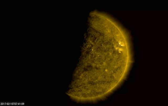
Several times a day for a few days the Earth completely blocked the Sun for about an hour due to NASA's Solar Dynamics Observatory's orbital path (Feb. 15, 2017). The edge of the Earth is not crisp, but kind of fuzzy due to Earth's atmosphere. This frame from a video shows the ending of one such eclipse over -- just seven minutes. The sun is shown in a wavelength of extreme ultraviolet light. These eclipses re-occur about every six months. The Moon blocks SDO's view of the sun on occasion as well. Movies are available at http://photojournal.jpl.nasa.gov/catalog/PIA21461
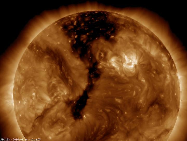
NASA Solar Dynamics Observatory shows a long coronal hole has rotated so that was temporarily facing right towards Earth Mar. 23-25, 2016. Coronal holes appear dark when viewed in some wavelengths of extreme ultraviolet light.
This composite image, combining data from NASA Chandra X-ray Observatory and Spitzer Space Telescope shows the star-forming cloud Cepheus B, located in our Milky Way galaxy about 2,400 light years from Earth
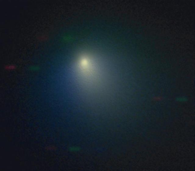
he Kitt Peak National Observatory 2.1-meter telescope observed comet Tempel 1 on April 11, 2005, when the comet was near its closest approach to the Earth. A pinkish dust jet is visible to the southwest, with the broader neutral gas coma surrounding it.
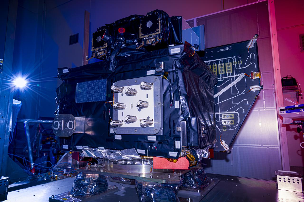
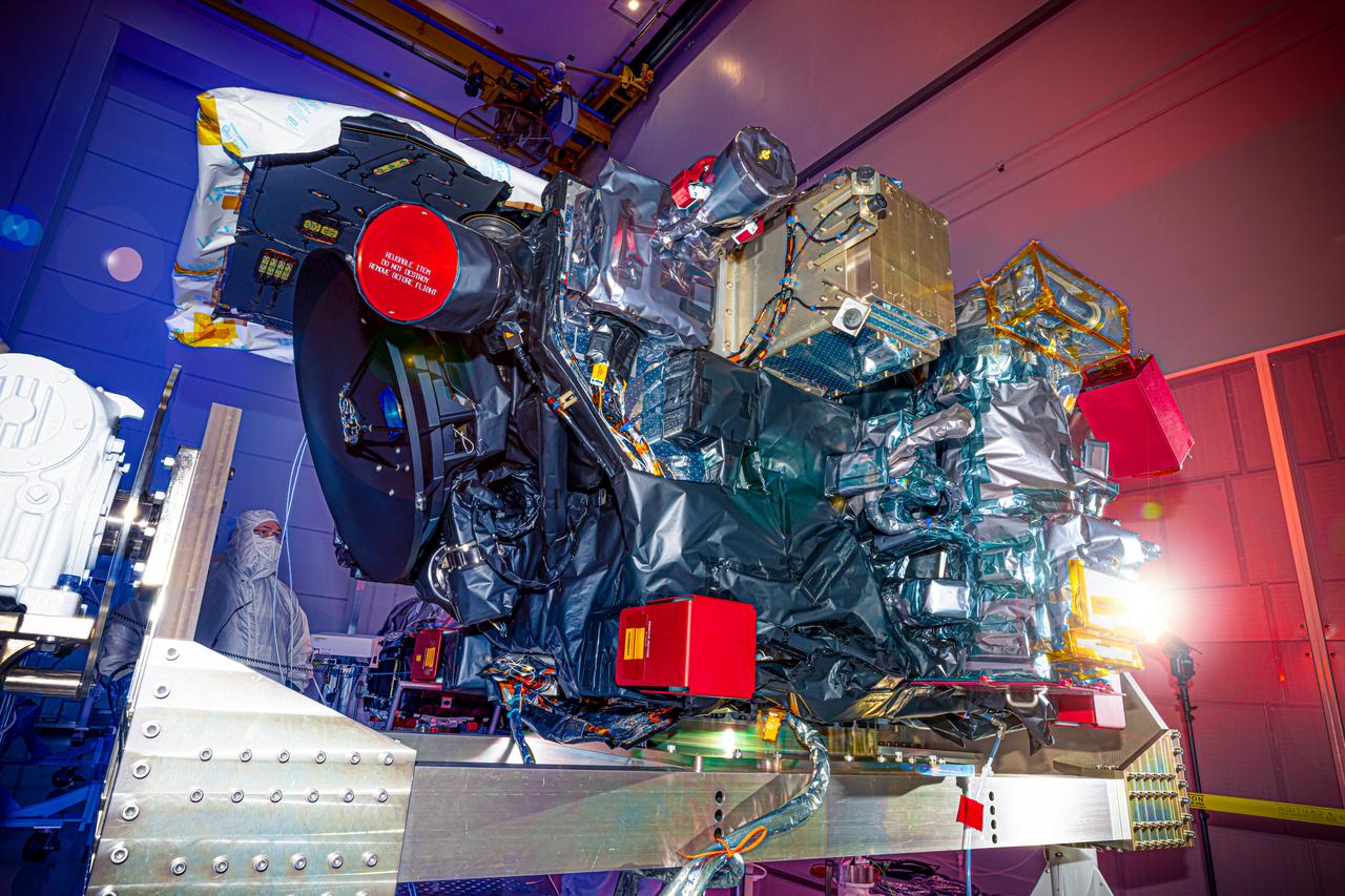
A photographer captures a photo of NASA’s Carruthers Geocorona Observatory on Wednesday, July 23, 2025, following arrival and unboxing of the observatory at the Astrotech Space Operations Facility near the agency’s Kennedy Space Center in Florida. The Carruthers Geocorona Observatory is a small satellite set to operate at Lagrange Point 1 (L1), an orbit point between the Earth and Sun about one million miles away. Carruthers will use its ultraviolet cameras to monitor how space weather from the Sun impacts the exosphere, the outermost part of Earth’s atmosphere. The observatory will launch as a rideshare with NASA’s (Interstellar Mapping and Acceleration Probe) no earlier than September 2025.
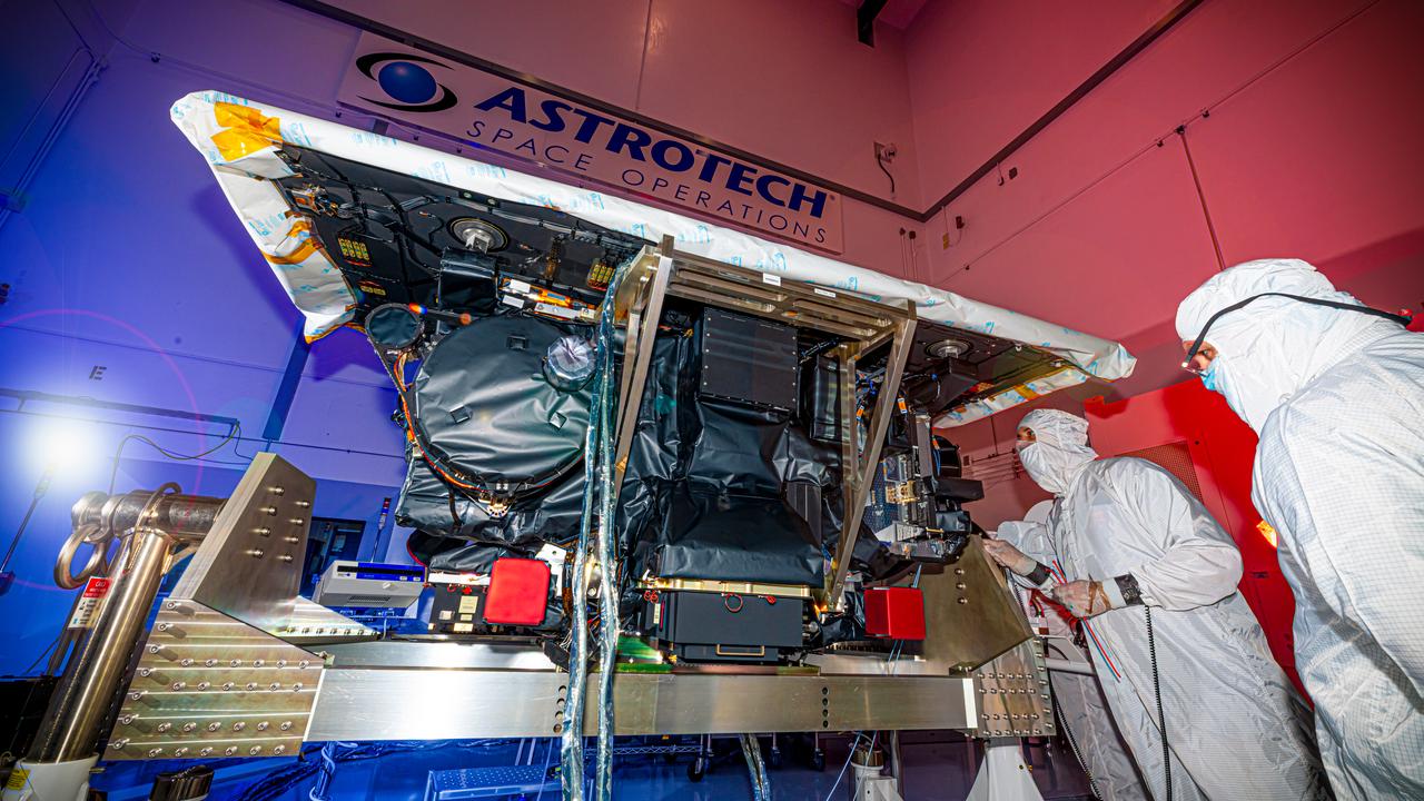
Technicians inspect NASA’s Carruthers Geocorona Observatory on Wednesday, July 23, 2025, following arrival and unboxing of the observatory at the Astrotech Space Operations Facility near the agency’s Kennedy Space Center in Florida. The Carruthers Geocorona Observatory is a small satellite set to operate at Lagrange Point 1 (L1), an orbit point between the Earth and Sun about one million miles away. Carruthers will use its ultraviolet cameras to monitor how space weather from the Sun impacts the exosphere, the outermost part of Earth’s atmosphere. The observatory will launch as a rideshare with NASA’s IMAP (Interstellar Mapping and Acceleration Probe) no earlier than September 2025.

Technicians inspect NASA’s Carruthers Geocorona Observatory on Wednesday, July 23, 2025, following arrival and unboxing of the observatory at the Astrotech Space Operations Facility near the agency’s Kennedy Space Center in Florida. The Carruthers Geocorona Observatory is a small satellite set to operate at Lagrange Point 1 (L1), an orbit point between the Earth and Sun about one million miles away. Carruthers will use its ultraviolet cameras to monitor how space weather from the Sun impacts the exosphere, the outermost part of Earth’s atmosphere. The observatory will launch as a rideshare with NASA’s IMAP (Interstellar Mapping and Acceleration Probe) no earlier than September 2025.
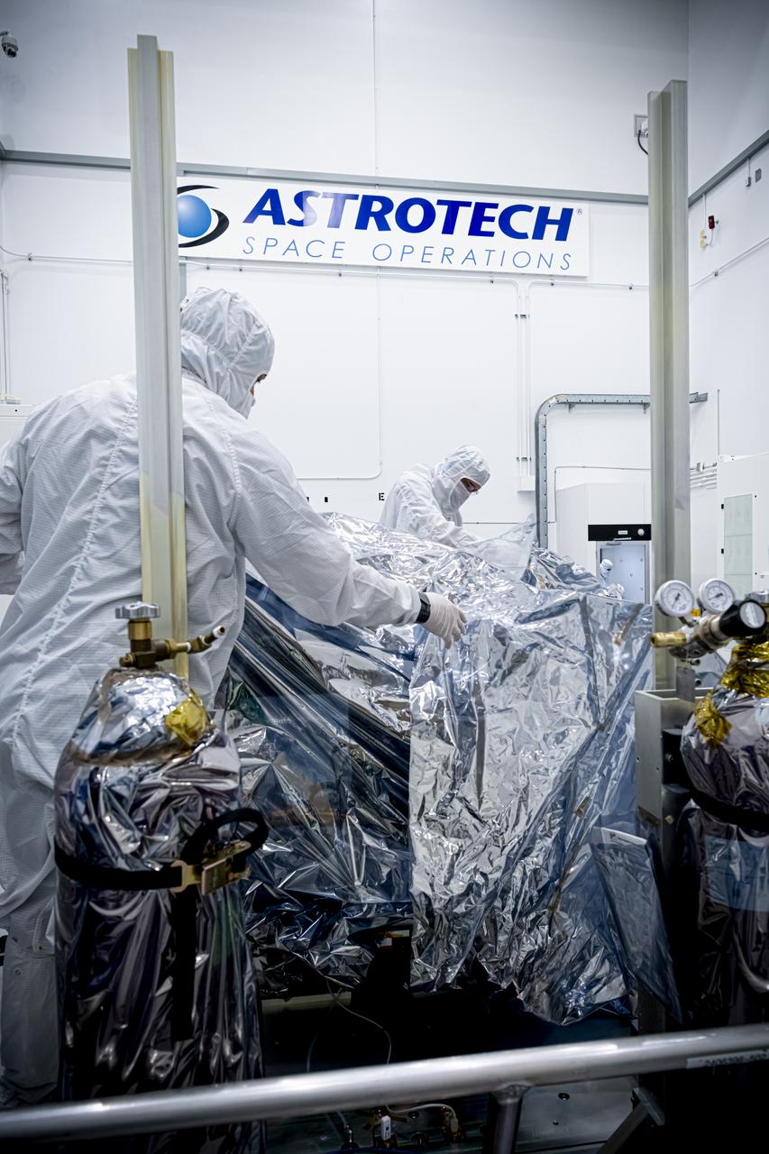
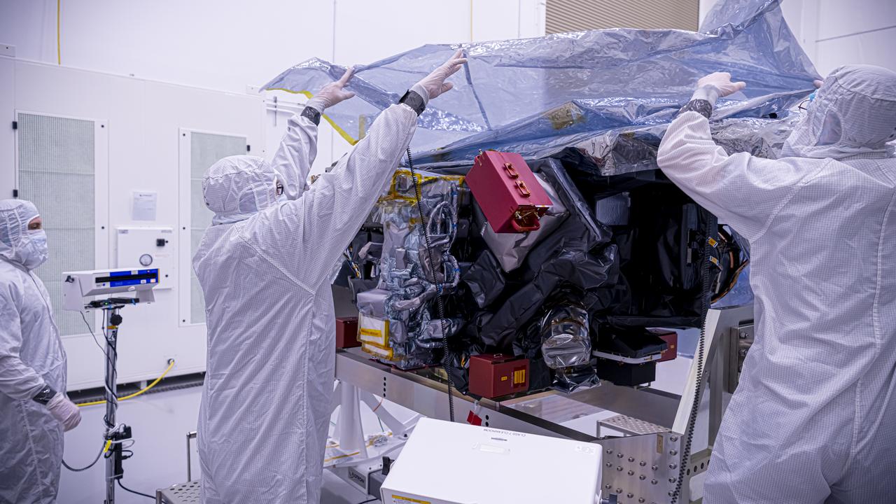
Technicians remove the protective casing covering NASA’s Carruthers Geocorona Observatory on Monday, July 21, 2025, at the Astrotech Space Operations Facility near the agency’s Kennedy Space Center in Florida. The Carruthers Geocorona Observatory is a small satellite set to operate at Lagrange Point 1 (L1), an orbit point between the Earth and Sun about one million miles away. Carruthers will use its ultraviolet cameras to monitor how space weather from the Sun impacts the exosphere, the outermost part of Earth’s atmosphere. The observatory will launch as a rideshare with NASA’s (Interstellar Mapping and Acceleration Probe) no earlier than September 2025.
Technicians remove the protective casing covering NASA’s Carruthers Geocorona Observatory on Monday, July 21, 2025, at the Astrotech Space Operations Facility near the agency’s Kennedy Space Center in Florida. The Carruthers Geocorona Observatory is a small satellite set to operate at Lagrange Point 1 (L1), an orbit point between the Earth and Sun about one million miles away. Carruthers will use its ultraviolet cameras to monitor how space weather from the Sun impacts the exosphere, the outermost part of Earth’s atmosphere. The observatory will launch as a rideshare with NASA’s (Interstellar Mapping and Acceleration Probe) no earlier than September 2025.
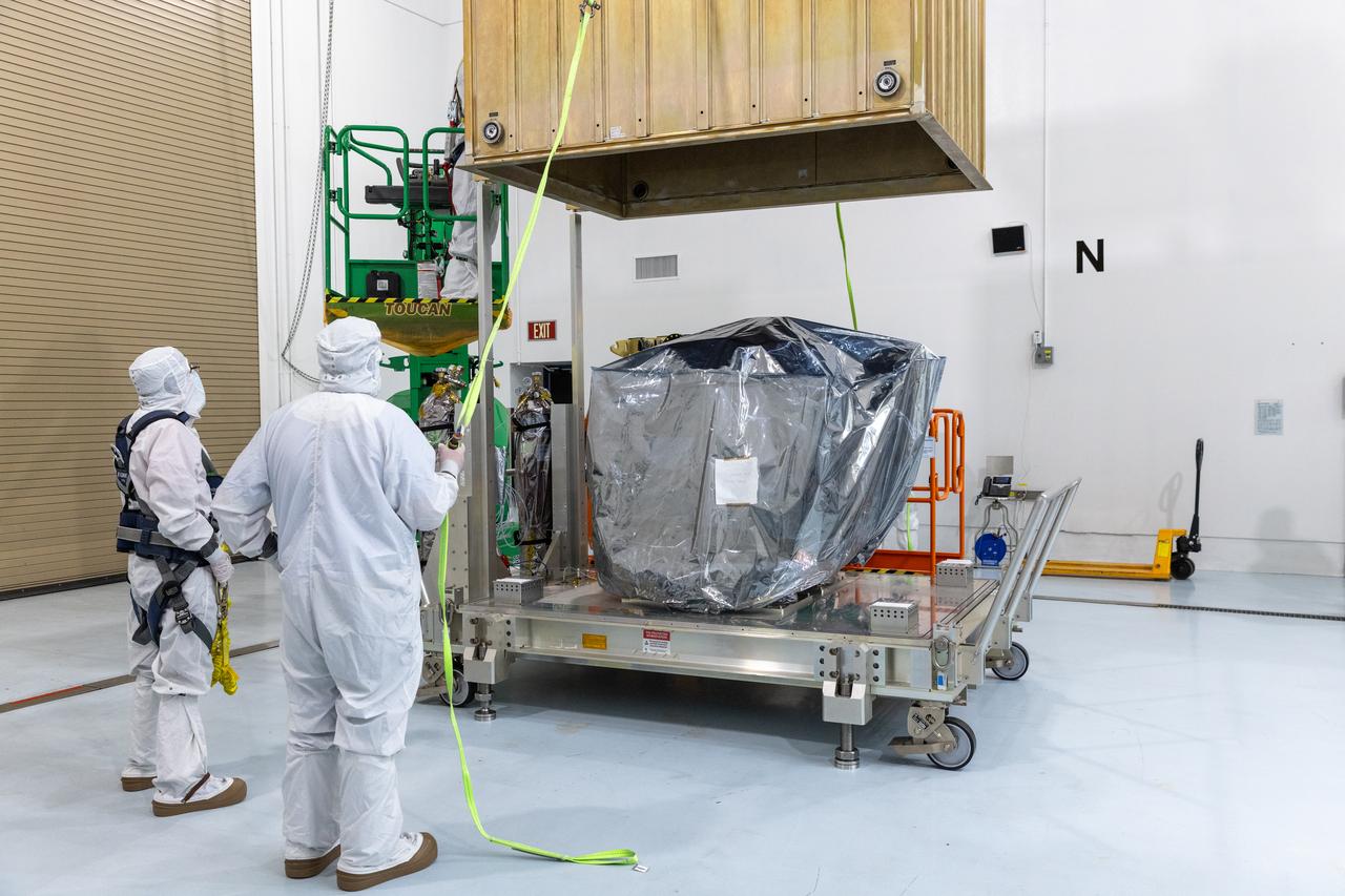
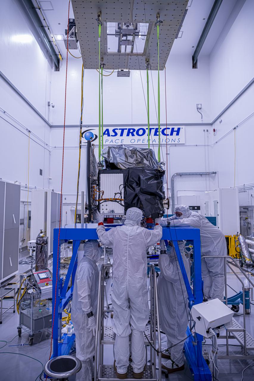
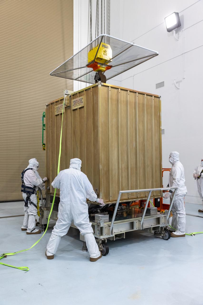
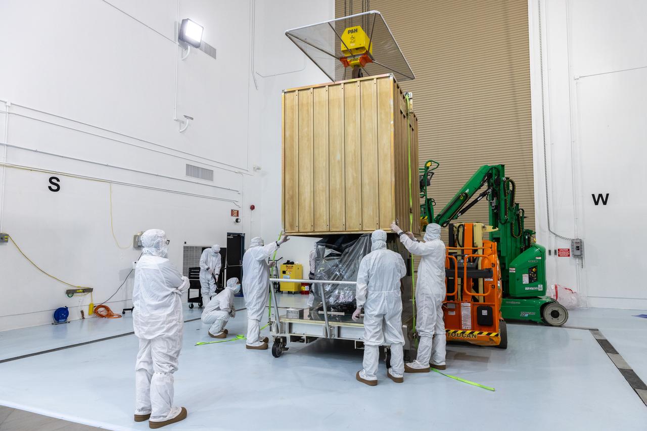
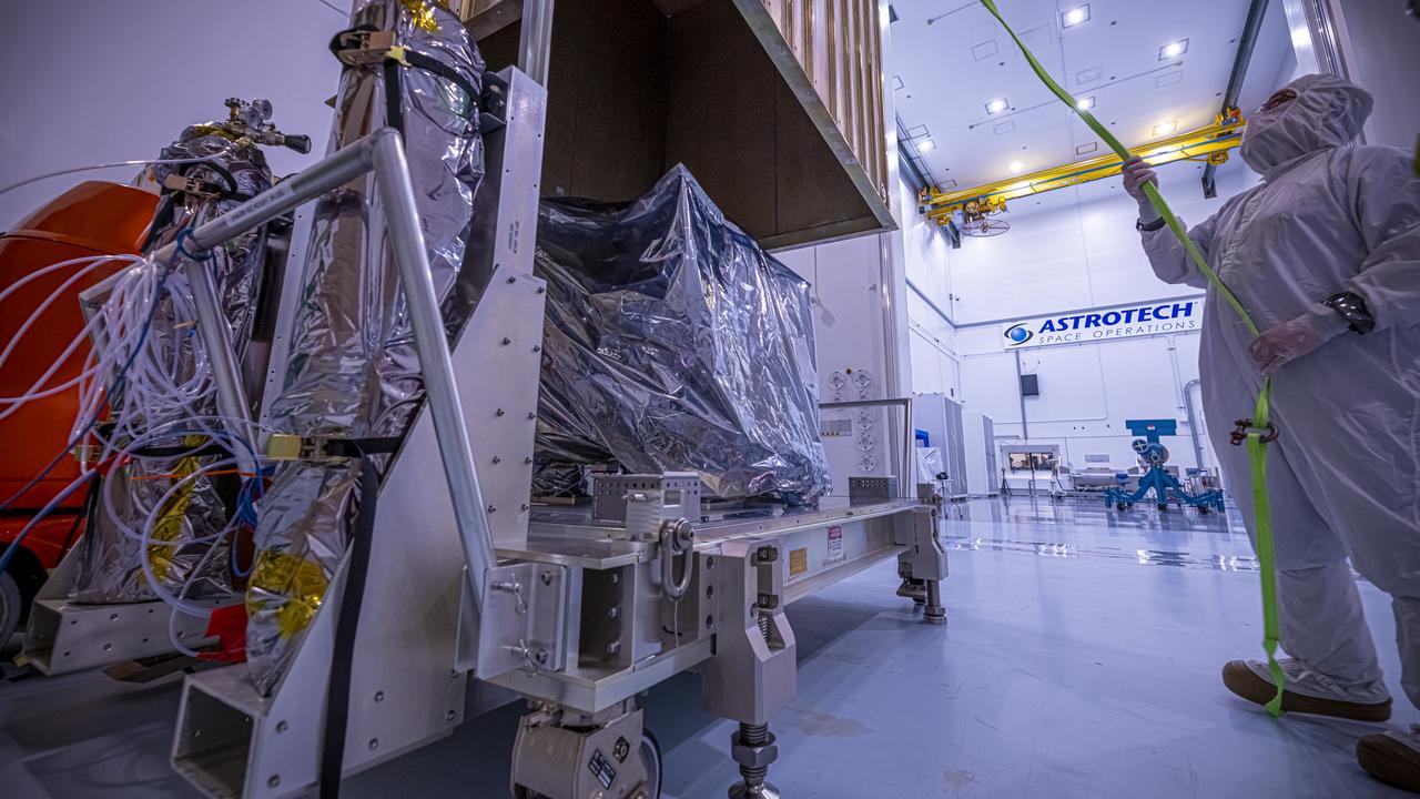
A crane lifts NASA’s Carruthers Geocorona Observatory on Thursday, July 24, 2025, at the Astrotech Space Operations Facility near the agency’s Kennedy Space Center in Florida. The Carruthers Geocorona Observatory is a small satellite set to operate at Lagrange Point 1 (L1), an orbit point between the Earth and Sun about one million miles away. Carruthers will use its ultraviolet cameras to monitor how space weather from the Sun impacts the exosphere, the outermost part of Earth’s atmosphere. The observatory will launch as a rideshare with NASA’s IMAP (Interstellar Mapping and Acceleration Probe) no earlier than September 2025.
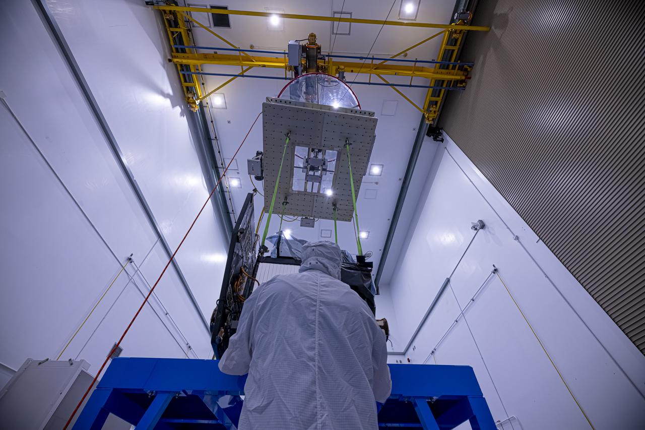
A crane lifts NASA’s Carruthers Geocorona Observatory on Thursday, July 24, 2025, at the Astrotech Space Operations Facility near the agency’s Kennedy Space Center in Florida. The Carruthers Geocorona Observatory is a small satellite set to operate at Lagrange Point 1 (L1), an orbit point between the Earth and Sun about one million miles away. Carruthers will use its ultraviolet cameras to monitor how space weather from the Sun impacts the exosphere, the outermost part of Earth’s atmosphere. The observatory will launch as a rideshare with NASA’s IMAP (Interstellar Mapping and Acceleration Probe) no earlier than September 2025.
Technicians remove the protective casing covering NASA’s Carruthers Geocorona Observatory on Monday, July 21, 2025, at the Astrotech Space Operations Facility near the agency’s Kennedy Space Center in Florida. The Carruthers Geocorona Observatory is a small satellite set to operate at Lagrange Point 1 (L1), an orbit point between the Earth and Sun about one million miles away. Carruthers will use its ultraviolet cameras to monitor how space weather from the Sun impacts the exosphere, the outermost part of Earth’s atmosphere. The observatory will launch as a rideshare with NASA’s (Interstellar Mapping and Acceleration Probe) no earlier than September 2025.
A crane lifts NASA’s Carruthers Geocorona Observatory on Thursday, July 24, 2025, at the Astrotech Space Operations Facility near the agency’s Kennedy Space Center in Florida. The Carruthers Geocorona Observatory is a small satellite set to operate at Lagrange Point 1 (L1), an orbit point between the Earth and Sun about one million miles away. Carruthers will use its ultraviolet cameras to monitor how space weather from the Sun impacts the exosphere, the outermost part of Earth’s atmosphere. The observatory will launch as a rideshare with NASA’s IMAP (Interstellar Mapping and Acceleration Probe) no earlier than September 2025.
A crane lifts NASA’s Carruthers Geocorona Observatory on Thursday, July 24, 2025, at the Astrotech Space Operations Facility near the agency’s Kennedy Space Center in Florida. The Carruthers Geocorona Observatory is a small satellite set to operate at Lagrange Point 1 (L1), an orbit point between the Earth and Sun about one million miles away. Carruthers will use its ultraviolet cameras to monitor how space weather from the Sun impacts the exosphere, the outermost part of Earth’s atmosphere. The observatory will launch as a rideshare with NASA’s IMAP (Interstellar Mapping and Acceleration Probe) no earlier than September 2025.
Technicians remove the protective casing covering NASA’s Carruthers Geocorona Observatory on Monday, July 21, 2025, at the Astrotech Space Operations Facility near the agency’s Kennedy Space Center in Florida. The Carruthers Geocorona Observatory is a small satellite set to operate at Lagrange Point 1 (L1), an orbit point between the Earth and Sun about one million miles away. Carruthers will use its ultraviolet cameras to monitor how space weather from the Sun impacts the exosphere, the outermost part of Earth’s atmosphere. The observatory will launch as a rideshare with NASA’s (Interstellar Mapping and Acceleration Probe) no earlier than September 2025.
Technicians prepare to remove the protective casing covering NASA’s Carruthers Geocorona Observatory on Monday, July 21, 2025, at the Astrotech Space Operations Facility near the agency’s Kennedy Space Center in Florida. The Carruthers Geocorona Observatory is a small satellite set to operate at Lagrange Point 1 (L1), an orbit point between the Earth and Sun about one million miles away. Carruthers will use its ultraviolet cameras to monitor how space weather from the Sun impacts the exosphere, the outermost part of Earth’s atmosphere. The observatory will launch as a rideshare with NASA’s (Interstellar Mapping and Acceleration Probe) no earlier than September 2025.
Technicians prepare to remove the protective casing covering NASA’s Carruthers Geocorona Observatory on Monday, July 21, 2025, at the Astrotech Space Operations Facility near the agency’s Kennedy Space Center in Florida. The Carruthers Geocorona Observatory is a small satellite set to operate at Lagrange Point 1 (L1), an orbit point between the Earth and Sun about one million miles away. Carruthers will use its ultraviolet cameras to monitor how space weather from the Sun impacts the exosphere, the outermost part of Earth’s atmosphere. The observatory will launch as a rideshare with NASA’s (Interstellar Mapping and Acceleration Probe) no earlier than September 2025.
Technicians prepare to remove the protective casing covering NASA’s Carruthers Geocorona Observatory on Monday, July 21, 2025, at the Astrotech Space Operations Facility near the agency’s Kennedy Space Center in Florida. The Carruthers Geocorona Observatory is a small satellite set to operate at Lagrange Point 1 (L1), an orbit point between the Earth and Sun about one million miles away. Carruthers will use its ultraviolet cameras to monitor how space weather from the Sun impacts the exosphere, the outermost part of Earth’s atmosphere. The observatory will launch as a rideshare with NASA’s (Interstellar Mapping and Acceleration Probe) no earlier than September 2025.
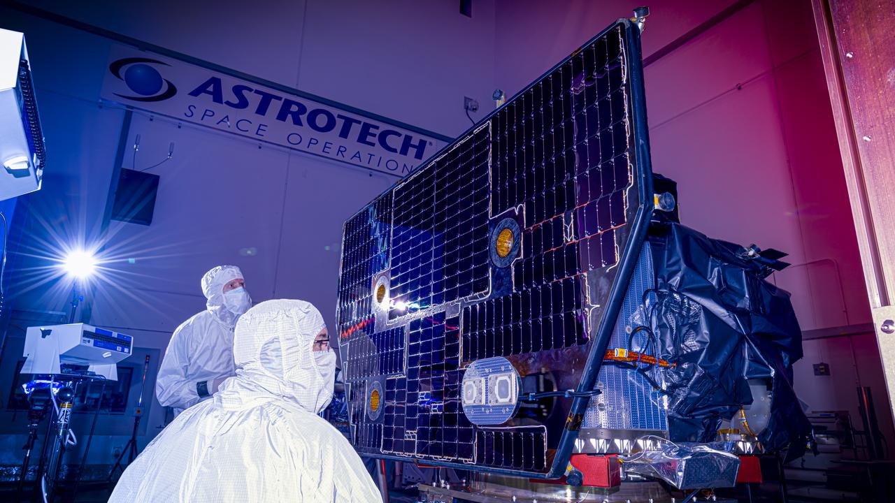
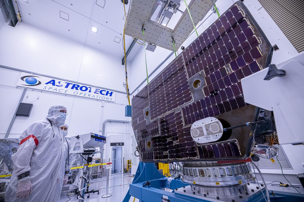
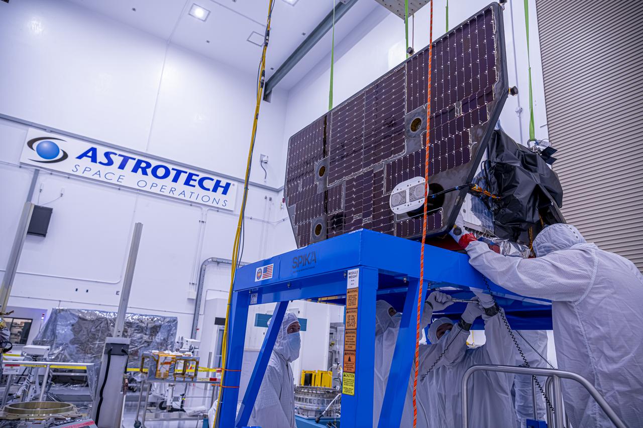
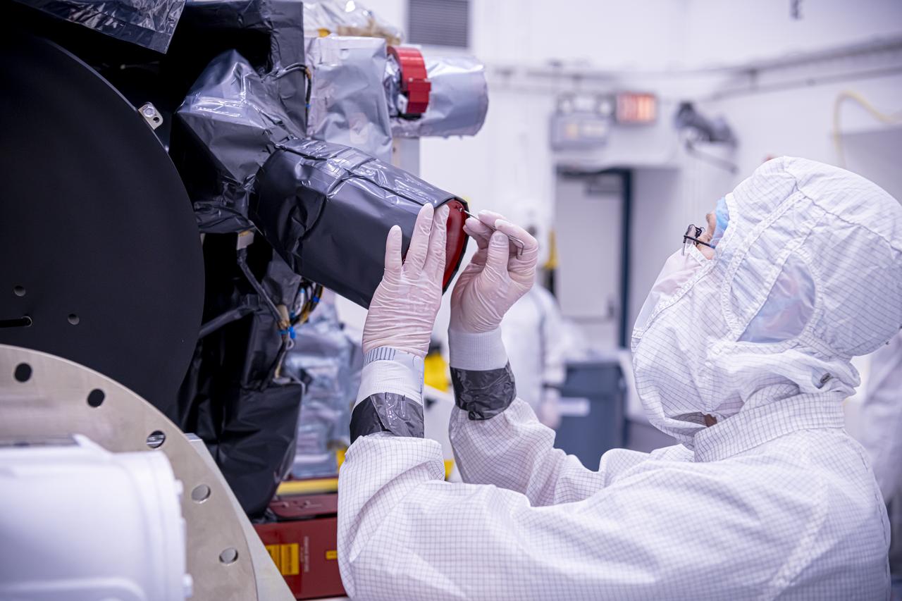
Technicians inspect the solar array panel attached to NASA’s Carruthers Geocorona Observatory on Wednesday, July 23, 2025, at the Astrotech Space Operations Facility near the agency’s Kennedy Space Center in Florida. The solar array will use the Sun to help power Carruthers Geocorona Observatory as it operates at Lagrange Point 1 (L1), an orbit point between the Earth and Sun about one million miles away. Carruthers will use its ultraviolet cameras to monitor how space weather from the Sun impacts the exosphere, the outermost part of Earth’s atmosphere. The observatory will launch as a rideshare with NASA’s IMAP (Interstellar Mapping and Acceleration Probe) no earlier than September 2025.
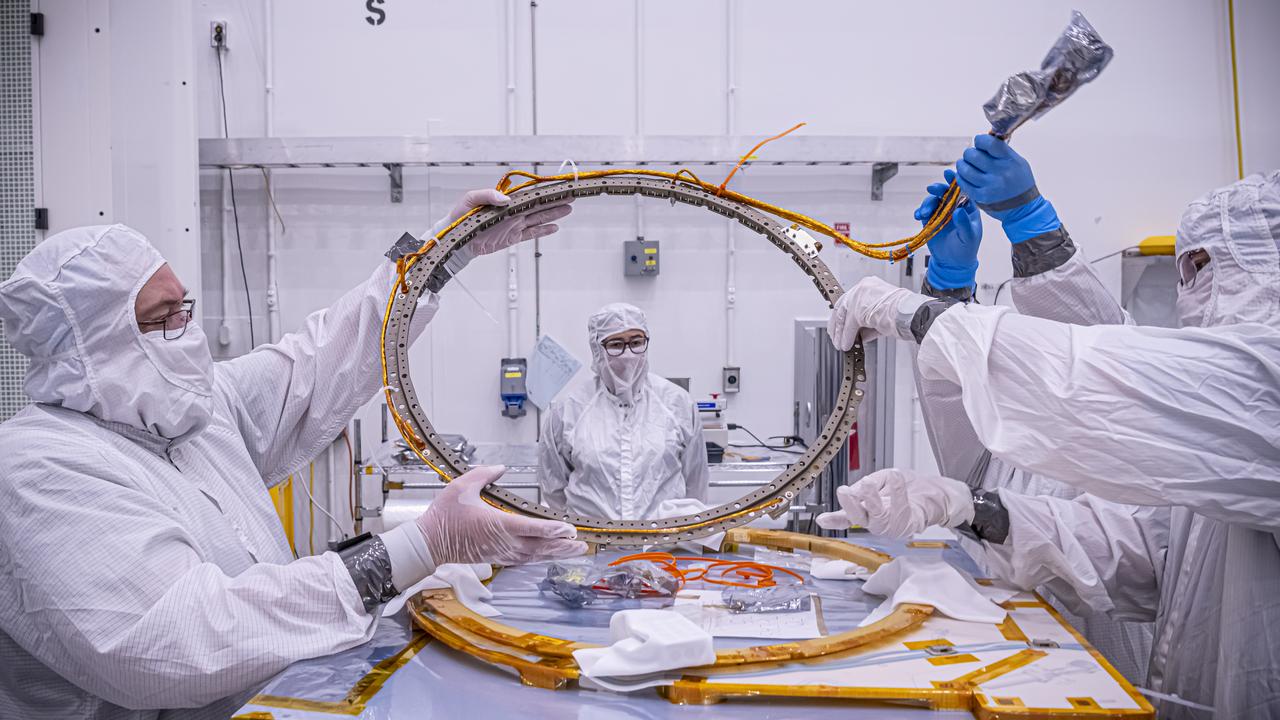
Technicians inspect a motorized light band for NASA’s Carruthers Geocorona Observatory on Tuesday, July 22, 2025, at the Astrotech Space Operations Facility near the agency’s Kennedy Space Center in Florida. The Carruthers Geocorona Observatory is a small satellite set to operate at Lagrange Point 1 (L1), an orbit point between the Earth and Sun about one million miles away. Carruthers will use its ultraviolet cameras to monitor how space weather from the Sun impacts the exosphere, the outermost part of Earth’s atmosphere. The observatory will launch as a rideshare with NASA’s IMAP (Interstellar Mapping and Acceleration Probe) no earlier than September 2025.
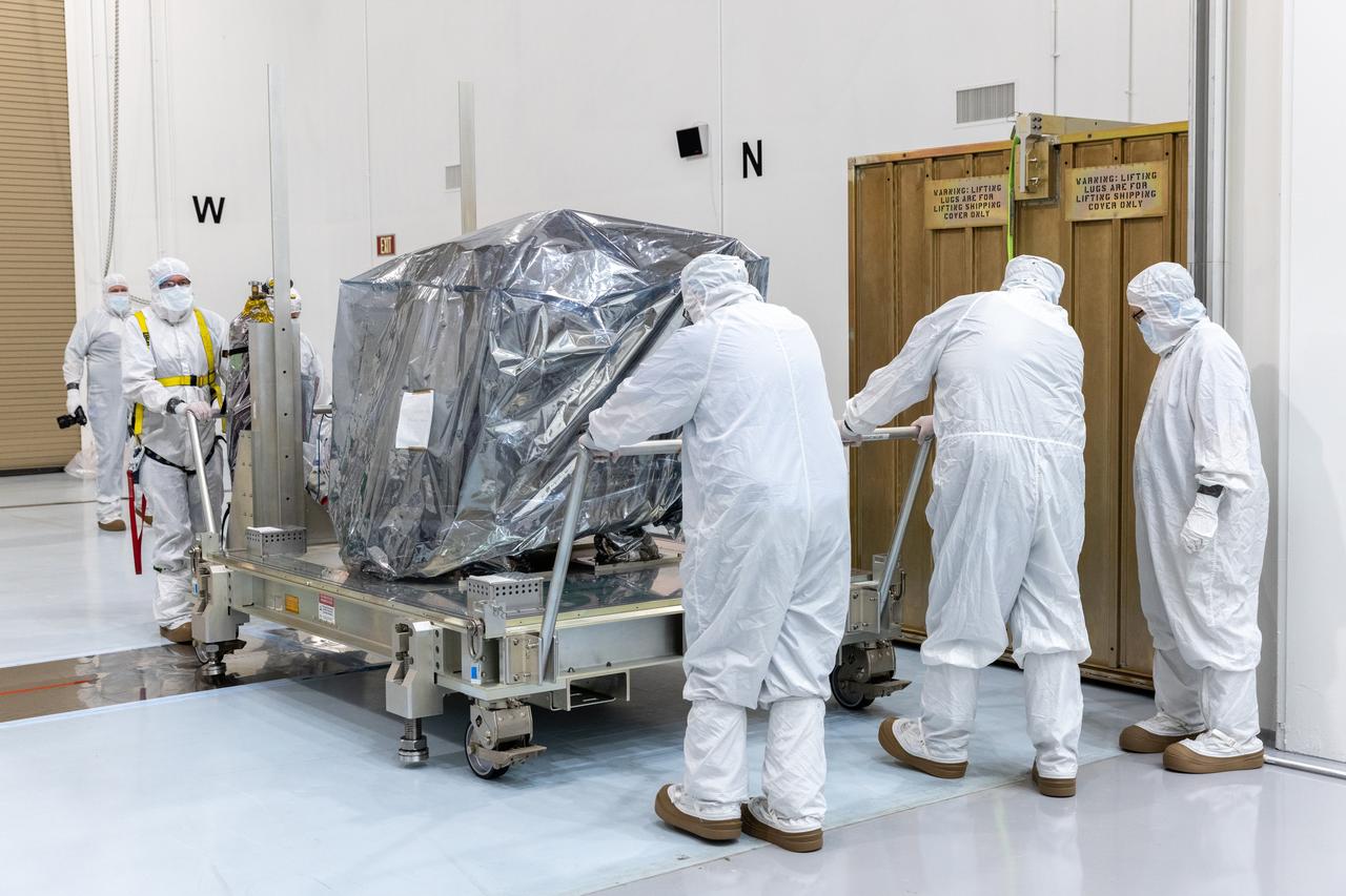
Technicians remove the transport container covering NASA’s Carruthers Geocorona Observatory on Monday, July 21, 2025, at the Astrotech Space Operations Facility near the agency’s Kennedy Space Center in Florida. The Carruthers Geocorona Observatory is a small satellite set to operate at Lagrange Point 1 (L1), an orbit point between the Earth and Sun about one million miles away. Carruthers will use its ultraviolet cameras to monitor how space weather from the Sun impacts the exosphere, the outermost part of Earth’s atmosphere. The observatory will launch as a rideshare with NASA’s IMAP (Interstellar Mapping and Acceleration Probe) no earlier than September 2025.
Technicians inspect the National Oceanic and Atmospheric Administration’s (NOAA) Space Weather Follow On–Lagrange 1 (SWFO-L1) Observatory on Thursday, July 24, 2025, following the arrival and unboxing of the observatory at the Astrotech Space Operations Facility near NASA’s Kennedy Space Center in Florida. The SWFO-L1 mission will monitor the Sun and near-Earth environment using a suite of instruments that provide real-time measurements of solar activity. The observatory will launch as a rideshare with NASA’s IMAP (Interstellar Mapping and Acceleration Probe) no earlier than September 2025.
Technicians inspect the National Oceanic and Atmospheric Administration’s (NOAA) Space Weather Follow On–Lagrange 1 (SWFO-L1) Observatory on Thursday, July 24, 2025, following the arrival and unboxing of the observatory at the Astrotech Space Operations Facility near NASA’s Kennedy Space Center in Florida. The SWFO-L1 mission will monitor the Sun and near-Earth environment using a suite of instruments that provide real-time measurements of solar activity. The observatory will launch as a rideshare with NASA’s IMAP (Interstellar Mapping and Acceleration Probe) no earlier than September 2025.
Technicians inspect the National Oceanic and Atmospheric Administration’s (NOAA) Space Weather Follow On–Lagrange 1 (SWFO-L1) Observatory on Thursday, July 24, 2025, following the arrival and unboxing of the observatory at the Astrotech Space Operations Facility near NASA’s Kennedy Space Center in Florida. The SWFO-L1 mission will monitor the Sun and near-Earth environment using a suite of instruments that provide real-time measurements of solar activity. The observatory will launch as a rideshare with NASA’s IMAP (Interstellar Mapping and Acceleration Probe) no earlier than September 2025.

Technicians inspect the National Oceanic and Atmospheric Administration’s (NOAA) Space Weather Follow On–Lagrange 1 (SWFO-L1) Observatory on Thursday, July 24, 2025, following the arrival and unboxing of the observatory at the Astrotech Space Operations Facility near NASA’s Kennedy Space Center in Florida. The SWFO-L1 mission will monitor the Sun and near-Earth environment using a suite of instruments that provide real-time measurements of solar activity. The observatory will launch as a rideshare with NASA’s IMAP (Interstellar Mapping and Acceleration Probe) no earlier than September 2025.
Technicians inspect the National Oceanic and Atmospheric Administration’s (NOAA) Space Weather Follow On–Lagrange 1 (SWFO-L1) Observatory on Thursday, July 24, 2025, following the arrival and unboxing of the observatory at the Astrotech Space Operations Facility near NASA’s Kennedy Space Center in Florida. The SWFO-L1 mission will monitor the Sun and near-Earth environment using a suite of instruments that provide real-time measurements of solar activity. The observatory will launch as a rideshare with NASA’s IMAP (Interstellar Mapping and Acceleration Probe) no earlier than September 2025.
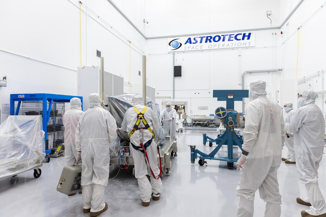
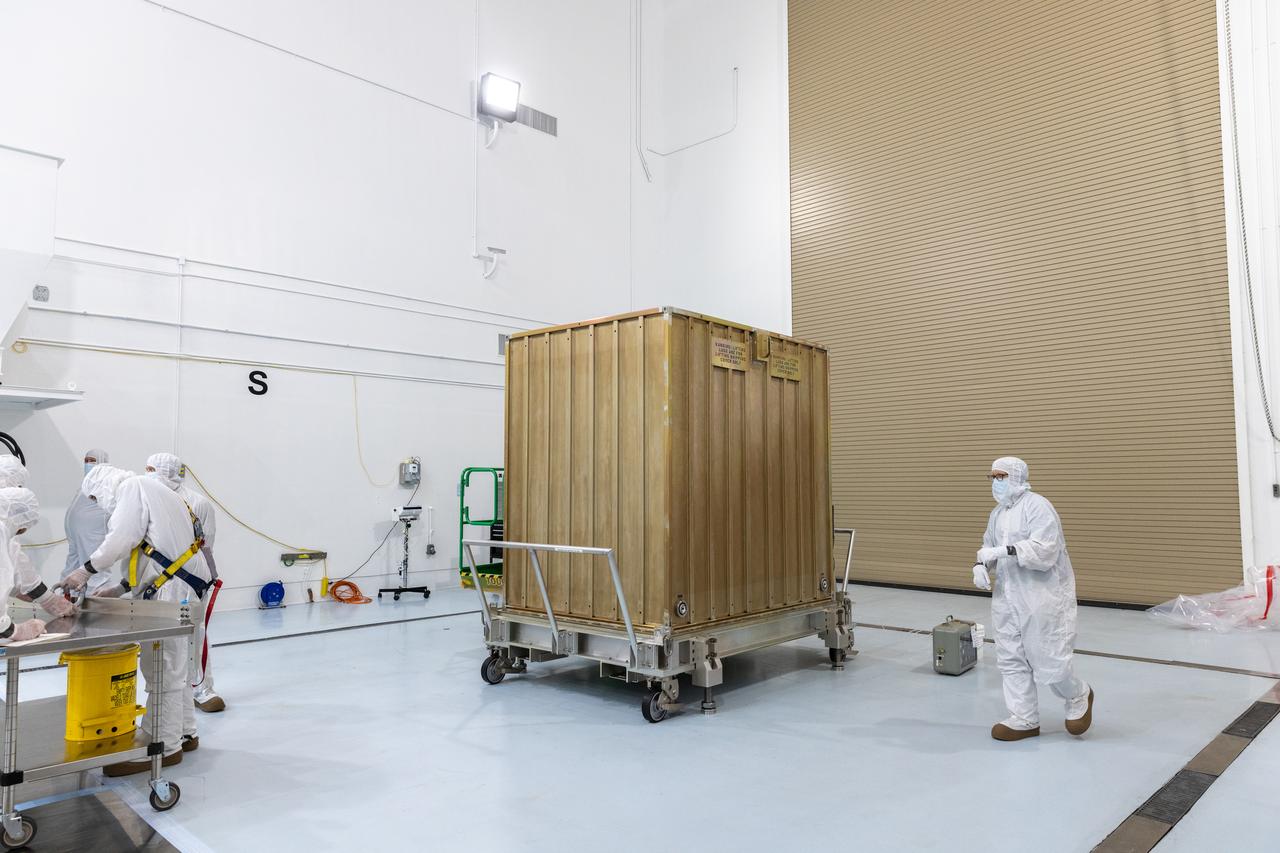
Technicians offloaded NASA’s Carruthers Geocorona Observatory following the spacecraft’s arrival on Sunday, July 20, 2025, at the Astrotech Space Operations Facility near the agency’s Kennedy Space Center in Florida. The Carruthers Geocorona Observatory is a small satellite set to operate at Lagrange Point 1 (L1), an orbit point between the Earth and Sun about one million miles away, to study the Earth’s exosphere, the outermost part of the atmosphere. Carruthers will use its ultraviolet cameras to monitor how space weather from the Sun impacts the exosphere.
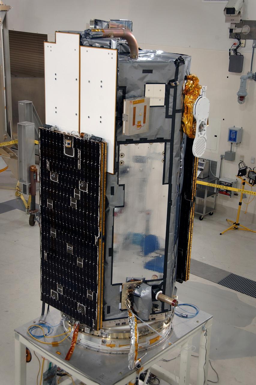
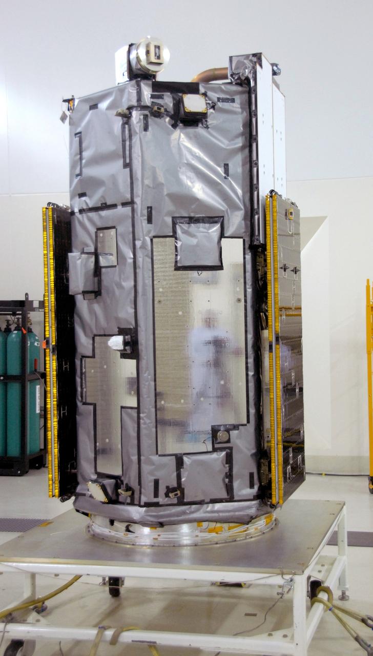
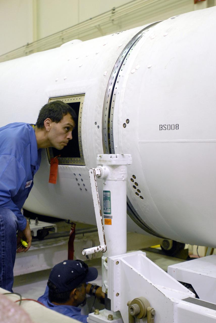
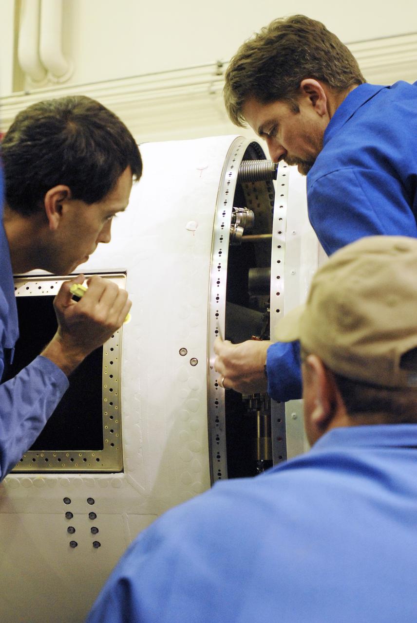
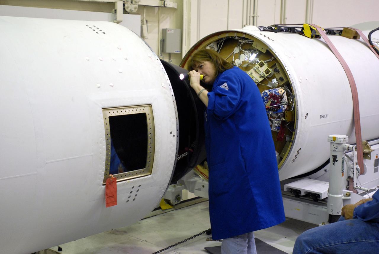
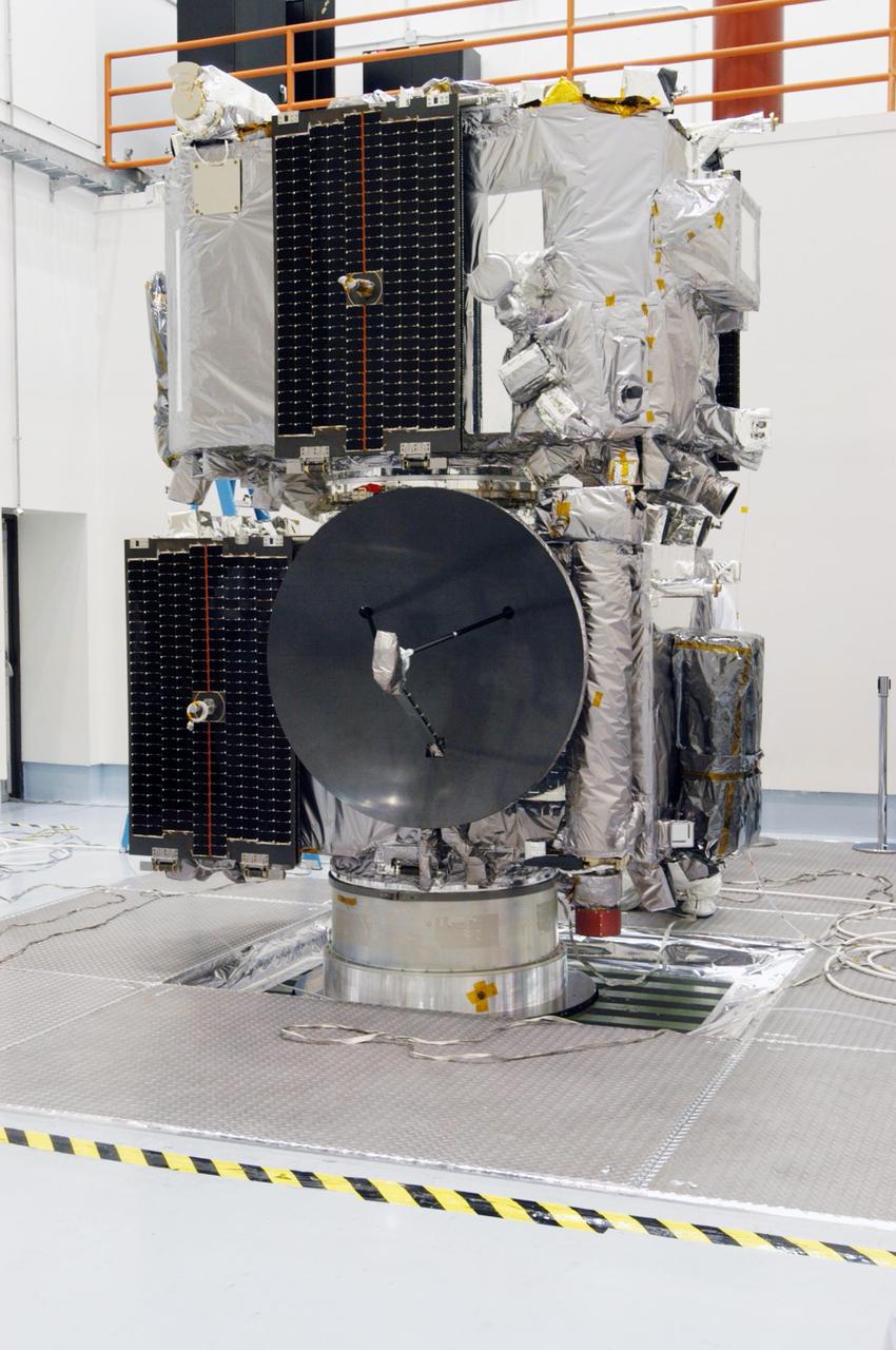
VANDENBERG AIR FORCE BASE, Calif. --Inside the Astrotech payload processing facility at Vandenberg Air Force Base in California, the Orbiting Carbon Observatory, or OCO, is displayed after blankets and edge tape were applied. The OCO is a new Earth-orbiting mission sponsored by NASA's Earth System Science Pathfinder Program. The observatory is targeted to launch Feb. 23 from Space Launch Complex 576-E at Vandenberg. Photo credit: NASA/VAFB
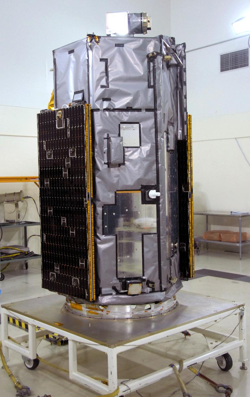
VANDENBERG AIR FORCE BASE, Calif. -- Inside the Astrotech payload processing facility, building 1032, at Vandenberg Air Force Base in California, the Orbiting Carbon Observatory, or OCO, is displayed after blankets and edge tape were applied. The OCO is a new Earth-orbiting mission sponsored by NASA's Earth System Science Pathfinder Program. The observatory is targeted to launch Jan. 15 from Space Launch Complex 576-E at Vandenberg. Photo credit: NASA/Robert Hargreaves Jr., VAFB
VANDENBERG AIR FORCE BASE, Calif. -- Inside the Astrotech payload processing facility, building 1032, at Vandenberg Air Force Base in California, the Orbiting Carbon Observatory, or OCO, is displayed after blankets and edge tape were applied. The OCO is a new Earth-orbiting mission sponsored by NASA's Earth System Science Pathfinder Program. The observatory is targeted to launch Jan. 15 from Space Launch Complex 576-E at Vandenberg. Photo credit: NASA/Robert Hargreaves Jr., VAFB
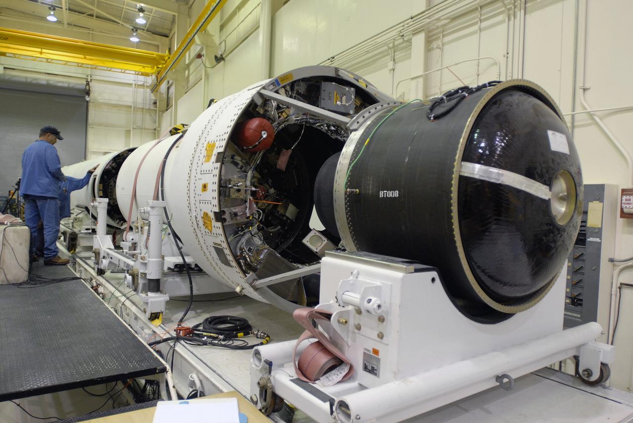
VANDENBERG AIR FORCE BASE, Calif. --In Space Launch Complex 576-E, Vandenberg Air Force Base in California, Stages 1 and 2 of the Taurus XL launch vehicle are being integrated for NASA's Orbiting Carbon Observatory, called OCO. OCO is a new Earth-orbiting mission sponsored by NASA's Earth System Science Pathfinder Program. The observatory is targeted to launch Feb. 23 from Space Launch Complex 576-E at Vandenberg. Photo credit: NASA/VAFB
VANDENBERG AIR FORCE BASE, Calif. -- Inside the Astrotech payload processing facility at Vandenberg Air Force Base in California, the Orbiting Carbon Observatory, or OCO, is displayed. The OCO is a new Earth-orbiting mission sponsored by NASA's Earth System Science Pathfinder Program. The observatory is targeted to launch Feb. 23 from Space Launch Complex 576-E at Vandenberg. Photo credit: NASA/VAFB
VANDENBERG AIR FORCE BASE, Calif. --Inside the Astrotech payload processing facility at Vandenberg Air Force Base in California, the Orbiting Carbon Observatory, or OCO, is displayed after blankets and edge tape were applied. The OCO is a new Earth-orbiting mission sponsored by NASA's Earth System Science Pathfinder Program. The observatory is targeted to launch Feb. 23 from Space Launch Complex 576-E at Vandenberg. Photo credit: NASA/VAFB
VANDENBERG AIR FORCE BASE, Calif. -- Space Launch Complex 576-E, Vandenberg Air Force Base in California, a worker checks the integration of the Taurus XL Stages 1 and 2. The Taurus is the launch vehicle for NASA's Orbiting Carbon Observatory, called OCO, a new Earth-orbiting mission sponsored by NASA's Earth System Science Pathfinder Program. The observatory is targeted to launch Feb. 23 from Space Launch Complex 576-E at Vandenberg. Photo credit: NASA/VAFB
VANDENBERG AIR FORCE BASE, Calif. --In Space Launch Complex 576-E, Vandenberg Air Force Base in California, Stages 1 and 2 of the Taurus XL launch vehicle are being integrated for NASA's Orbiting Carbon Observatory, called OCO. OCO is a new Earth-orbiting mission sponsored by NASA's Earth System Science Pathfinder Program. The observatory is targeted to launch Feb. 23 from Space Launch Complex 576-E at Vandenberg. Photo credit: NASA/VAFB
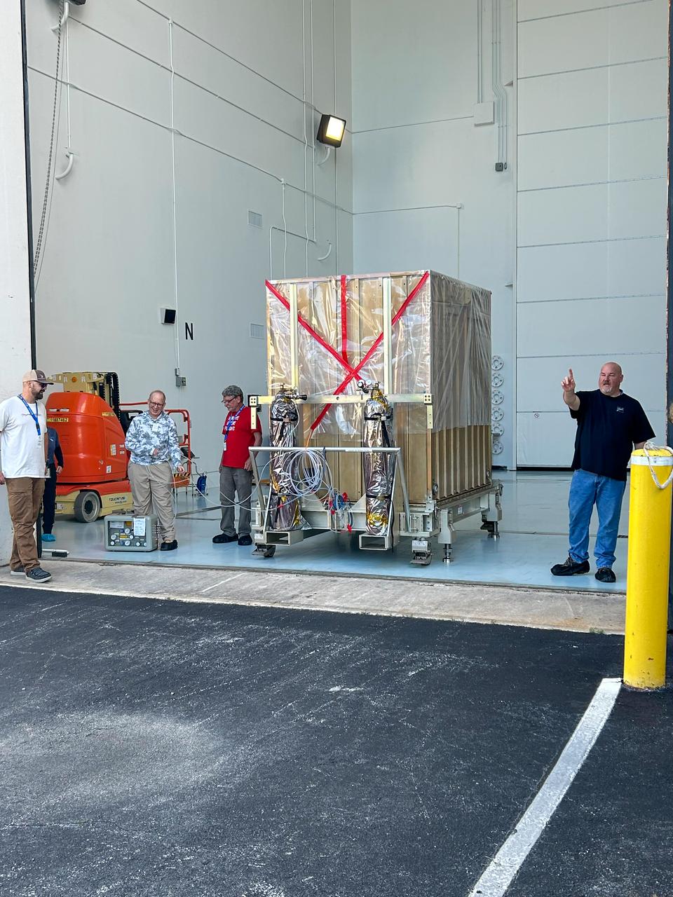
Technicians offloaded NASA’s Carruthers Geocorona Observatory following the spacecraft’s arrival on Monday, July 201, 2025, at the Astrotech Space Operations Facility near the agency’s Kennedy Space Center in Florida. The Carruthers Geocorona Observatory is a small satellite set to operate at Lagrange Point 1 (L1), an orbit point between the Earth and Sun about one million miles away, to study the Earth’s exosphere, the outermost part of the atmosphere. Carruthers will use its ultraviolet cameras to monitor how space weather from the Sun impacts the exosphere.
VANDENBERG AIR FORCE BASE, Calif. --In Space Launch Complex 576-E, Vandenberg Air Force Base in California, Stages 1 and 2 of the Taurus XL launch vehicle are being integrated for NASA's Orbiting Carbon Observatory, called OCO. OCO is a new Earth-orbiting mission sponsored by NASA's Earth System Science Pathfinder Program. The observatory is targeted to launch Feb. 23 from Space Launch Complex 576-E at Vandenberg. Photo credit: NASA/VAFB

VANDENBERG AIR FORCE BASE, Calif. -- Space Launch Complex 576-E, Vandenberg Air Force Base in California, a worker checks the integration of the Taurus XL Stages 1 and 2. The Taurus is the launch vehicle for NASA's Orbiting Carbon Observatory, called OCO, a new Earth-orbiting mission sponsored by NASA's Earth System Science Pathfinder Program. The observatory is targeted to launch Feb. 23 from Space Launch Complex 576-E at Vandenberg. Photo credit: NASA/VAFB

VANDENBERG AIR FORCE BASE, Calif. --Inside the Astrotech payload processing facility at Vandenberg Air Force Base in California, the Orbiting Carbon Observatory, or OCO, is displayed after blankets and edge tape were applied. The OCO is a new Earth-orbiting mission sponsored by NASA's Earth System Science Pathfinder Program. The observatory is targeted to launch Feb. 23 from Space Launch Complex 576-E at Vandenberg. Photo credit: NASA/VAFB
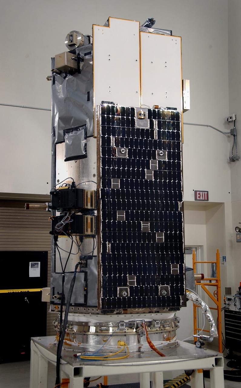
VANDENBERG AIR FORCE BASE, Calif. -- Inside the Astrotech payload processing facility at Vandenberg Air Force Base in California, the Orbiting Carbon Observatory, or OCO, is displayed. The OCO is a new Earth-orbiting mission sponsored by NASA's Earth System Science Pathfinder Program. The observatory is targeted to launch Feb. 23 from Space Launch Complex 576-E at Vandenberg. Photo credit: NASA/VAFB
VANDENBERG AIR FORCE BASE, Calif. --In Space Launch Complex 576-E, Vandenberg Air Force Base in California, Stages 1 and 2 of the Taurus XL launch vehicle are being integrated for NASA's Orbiting Carbon Observatory, called OCO. OCO is a new Earth-orbiting mission sponsored by NASA's Earth System Science Pathfinder Program. The observatory is targeted to launch Feb. 23 from Space Launch Complex 576-E at Vandenberg. Photo credit: NASA/VAFB

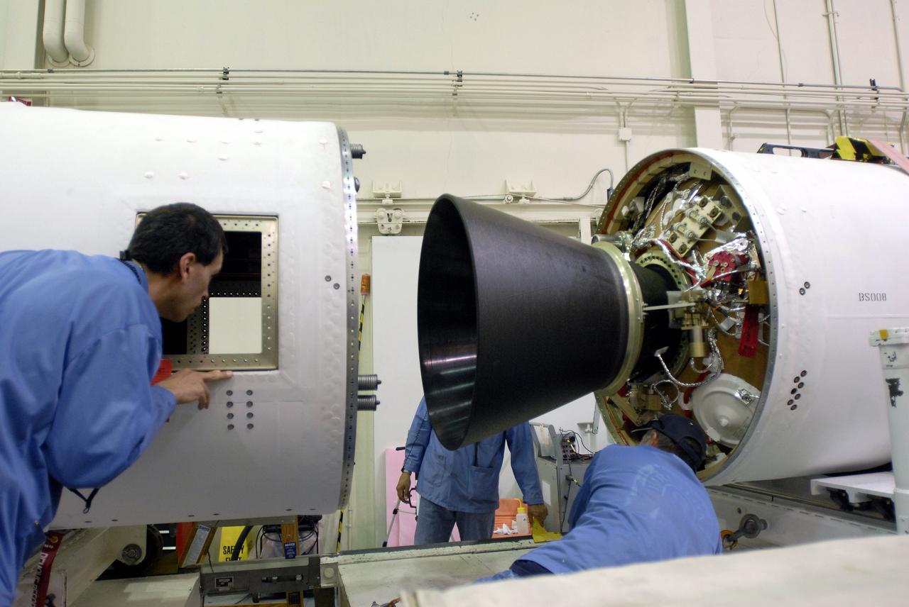
VANDENBERG AIR FORCE BASE, Calif. -- On Space Launch Complex 576-E at Vandenberg Air Force Base in California, an Orbital Sciences technician connects ground wires to the Stage 3 motor of the Taurus XL launch vehicle for NASA’s Orbiting Carbon Observatory, or OCO. The encapsulated cargo element containing the observatory is integrated with the vehicle. The OCO is an Earth-orbiting mission sponsored by NASA's Earth System Science Pathfinder Program. The observatory will collect precise global measurements of carbon dioxide in the Earth's atmosphere. Scientists will analyze the data returned to better understand the natural processes and human activities that regulate the abundance and distribution of this important greenhouse gas. Launch is targeted for Feb. 24 from Space Launch Complex 576-E at Vandenberg. Photo credit: VAFB/Wayne North
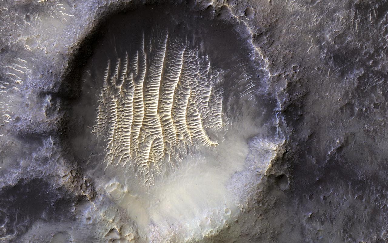
The crater in the center of this HiRISE image defines where zero longitude is on Mars, like the Greenwich Observatory does for the Earth. Originally, the larger crater that this crater sits within, called Airy Crater, defined zero longitude for the Red Planet. But as higher resolution images became available, a smaller feature was needed. This crater, called Airy-0 (zero), was selected because it would require no adjustment of existing maps. These days, longitude on Mars is measured even more precisely using radio tracking of landers such as InSight, but everything is still defined to keep zero longitude centered on this crater. https://photojournal.jpl.nasa.gov/catalog/PIA25090
VANDENBERG AIR FORCE BASE, Calif. – Stages 1, 2 and 3 of Orbital Sciences’ Taurus XL launch vehicle for NASA’s Orbiting Carbon Observatory, or OCO, have arrived and are prepared for erection at Space Launch Complex 576-E at Vandenberg Air Force Base in California. The OCO is an Earth-orbiting mission sponsored by NASA's Earth System Science Pathfinder Program. The observatory will collect precise global measurements of carbon dioxide in the Earth's atmosphere. Scientists will analyze the data returned to better understand the natural processes and human activities that regulate the abundance and distribution of this important greenhouse gas. Launch is targeted for 1:51:30 a.m. PST Feb. 24. Photo credit: VAFB

VANDENBERG AIR FORCE BASE, Calif. -- Stages 1, 2 and 3 of Orbital Sciences’ Taurus XL launch vehicle for NASA’s Orbiting Carbon Observatory, or OCO, arrive at Space Launch Complex 576-E at Vandenberg Air Force Base in California. The OCO is an Earth-orbiting mission sponsored by NASA's Earth System Science Pathfinder Program. The observatory will collect precise global measurements of carbon dioxide in the Earth's atmosphere. Scientists will analyze the data returned to better understand the natural processes and human activities that regulate the abundance and distribution of this important greenhouse gas. Launch is targeted for 1:51:30 a.m. PST Feb. 24. Photo credit: VAFB
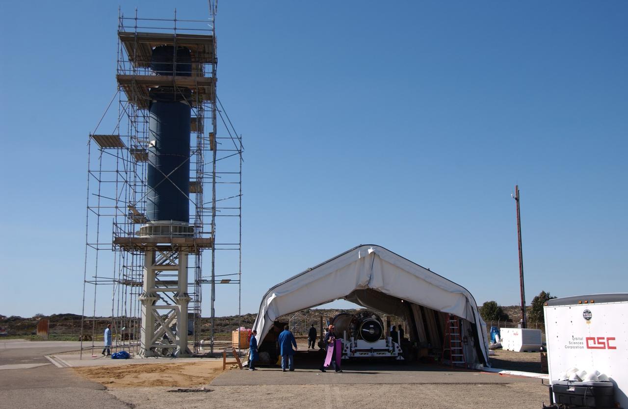
VANDENBERG AIR FORCE BASE, Calif. – Workers prepare to erect Stages 1, 2 and 3 of Orbital Sciences’ Taurus XL launch vehicle for NASA’s Orbiting Carbon Observatory, or OCO, at Space Launch Complex 576-E at Vandenberg Air Force Base in California. The OCO is an Earth-orbiting mission sponsored by NASA's Earth System Science Pathfinder Program. The observatory will collect precise global measurements of carbon dioxide in the Earth's atmosphere. Scientists will analyze the data returned to better understand the natural processes and human activities that regulate the abundance and distribution of this important greenhouse gas. Launch is targeted for 1:51:30 a.m. PST Feb. 24. Photo credit: VAFB
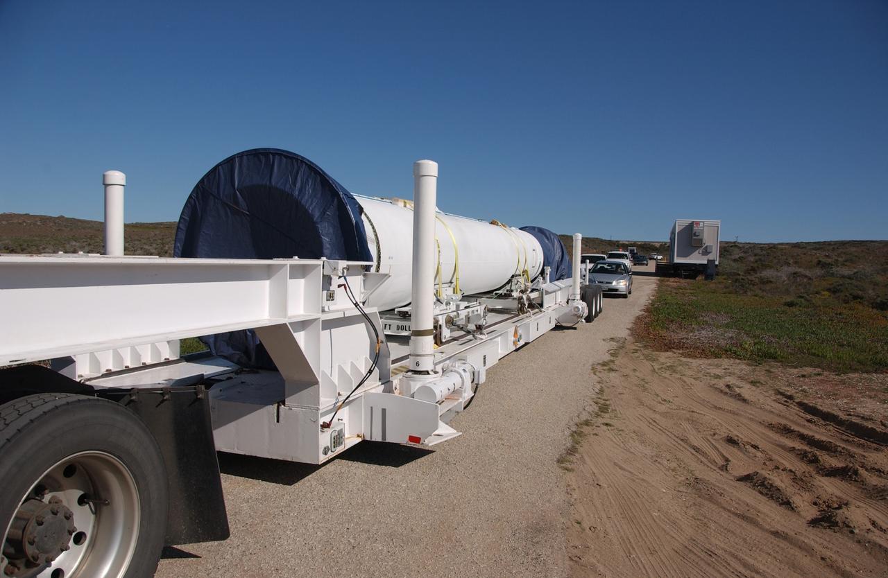
VANDENBERG AIR FORCE BASE, Calif. -- Stages 1, 2 and 3 of Orbital Sciences’ Taurus XL launch vehicle for NASA’s Orbiting Carbon Observatory, or OCO, are transported from Building 1555 to Space Launch Complex 576-E at Vandenberg Air Force Base in California. The OCO is an Earth-orbiting mission sponsored by NASA's Earth System Science Pathfinder Program. The observatory will collect precise global measurements of carbon dioxide in the Earth's atmosphere. Scientists will analyze the data returned to better understand the natural processes and human activities that regulate the abundance and distribution of this important greenhouse gas. Launch is targeted for 1:51:30 a.m. PST Feb. 24. Photo credit: VAFB
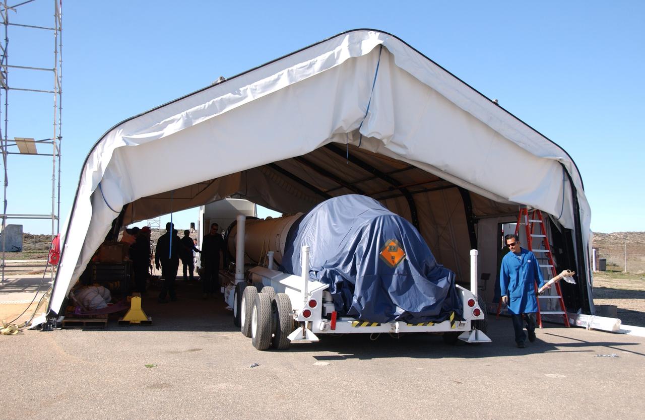
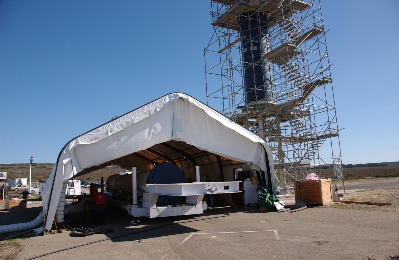
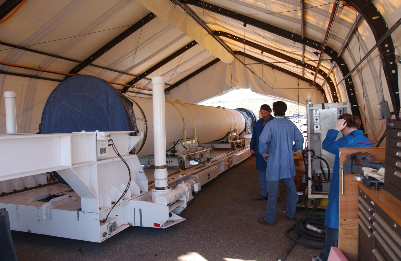
VANDENBERG AIR FORCE BASE, Calif. -- Stages 1, 2 and 3 of Orbital Sciences’ Taurus XL launch vehicle for NASA’s Orbiting Carbon Observatory, or OCO, are parked under a tent at Space Launch Complex 576-E at Vandenberg Air Force Base in California. The OCO is an Earth-orbiting mission sponsored by NASA's Earth System Science Pathfinder Program. The observatory will collect precise global measurements of carbon dioxide in the Earth's atmosphere. Scientists will analyze the data returned to better understand the natural processes and human activities that regulate the abundance and distribution of this important greenhouse gas. Launch is targeted for 1:51:30 a.m. PST Feb. 24. Photo credit: VAFB
VANDENBERG AIR FORCE BASE, Calif. – Stages 1, 2 and 3 of Orbital Sciences’ Taurus XL launch vehicle for NASA’s Orbiting Carbon Observatory, or OCO, have arrived and are prepared for lifting onto Space Launch Complex 576-E at Vandenberg Air Force Base in California. The OCO is an Earth-orbiting mission sponsored by NASA's Earth System Science Pathfinder Program. The observatory will collect precise global measurements of carbon dioxide in the Earth's atmosphere. Scientists will analyze the data returned to better understand the natural processes and human activities that regulate the abundance and distribution of this important greenhouse gas. Launch is targeted for 1:51:30 a.m. PST Feb. 24. Photo credit: VAFB
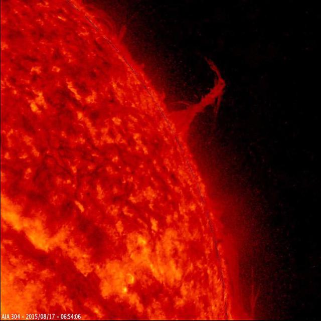
This still image from an animation from NASA GSFC Solar Dynamics Observatory shows a single plume of plasma, many times taller than the diameter of Earth, spewing streams of particles for over two days Aug. 17-19, 2015 before breaking apart. At times, its shape resembled the Eiffel Tower. Other lesser plumes and streams of particles can be seen dancing above the solar surface as well. The action was observed in a wavelength of extreme ultraviolet light. http://photojournal.jpl.nasa.gov/catalog/PIA19875
These first radar images of 2015 TB145 from the National Science Foundation 1,000-foot 305-meter Arecibo Observatory in Puerto Rico, indicate the near-Earth object is spherical in shape and approximately 2,000 feet 600 meters in diameter. The radar images were taken on Oct. 30, 2015, and the image resolution is 25 feet (7.5 meters) per pixel. The celestial object is more than likely a dead comet that has shed its volatiles after numerous passes around the sun. http://photojournal.jpl.nasa.gov/catalog/PIA20040

Astronomers have made the most detailed study yet of an extremely massive young galaxy cluster using three of NASA's Great Observatories. This multi-wavelength image shows this galaxy cluster, called IDCS J1426.5+3508 (IDCS 1426 for short), in X-rays recorded by the Chandra X-ray Observatory in blue, visible light observed by the Hubble Space Telescope in green, and infrared light detected by the Spitzer Space Telescope in red. This rare galaxy cluster, which is located 10 billion light-years from Earth, is almost as massive as 500 trillion suns. This object has important implications for understanding how such megastructures formed and evolved early in the universe. The light astronomers observed from IDCS 1426 began its journey to Earth when the universe was less than a third of its current age. It is the most massive galaxy cluster detected at such an early time. First discovered by the Spitzer Space Telescope in 2012, IDCS 1426 was then observed using the Hubble Space Telescope and the Keck Observatory to determine its distance. Observations from the Combined Array for Millimeter-wave Astronomy indicated it was extremely massive. New data from the Chandra X-ray Observatory confirm the galaxy cluster's mass and show that about 90 percent of this mass is in the form of dark matter -- the mysterious substance that has so far been detected only through its gravitational pull on normal matter composed of atoms. http://photojournal.jpl.nasa.gov/catalog/PIA20063
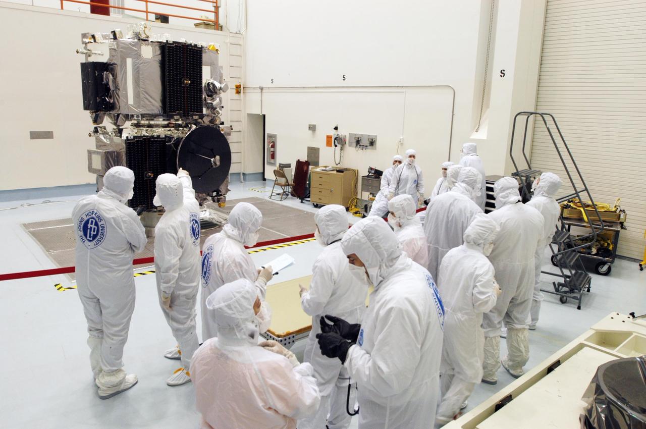
KENNEDY SPACE CENTER, FLA. - The STEREO observatories are the focus of attention at a media viewing held at Astrotech Space Operations in Titusville, Fla., on Aug. 11. The two observatories were mated for launch but will separate into different orbits for their mission. STEREO stands for Solar Terrestrial Relations Observatory. The STEREO mission is the first to take measurements of the sun and solar wind in 3-dimension. This new view will improve our understanding of space weather and its impact on the Earth. STEREO is expected to lift off on Aug. 31, from Launch Pad 17-B on Cape Canaveral Air Force Station in Florida. Photo credit: NASA/George Shelton.
KENNEDY SPACE CENTER, FLA. - The STEREO observatories are the focus of attention at a media viewing held at Astrotech Space Operations in Titusville, Fla., on Aug. 11. The two observatories were mated for launch but will separate into different orbits for their mission. STEREO stands for Solar Terrestrial Relations Observatory. The STEREO mission is the first to take measurements of the sun and solar wind in 3-dimension. This new view will improve our understanding of space weather and its impact on the Earth. STEREO is expected to lift off on Aug. 31, from Launch Pad 17-B on Cape Canaveral Air Force Station in Florida. Photo credit: NASA/George Shelton.

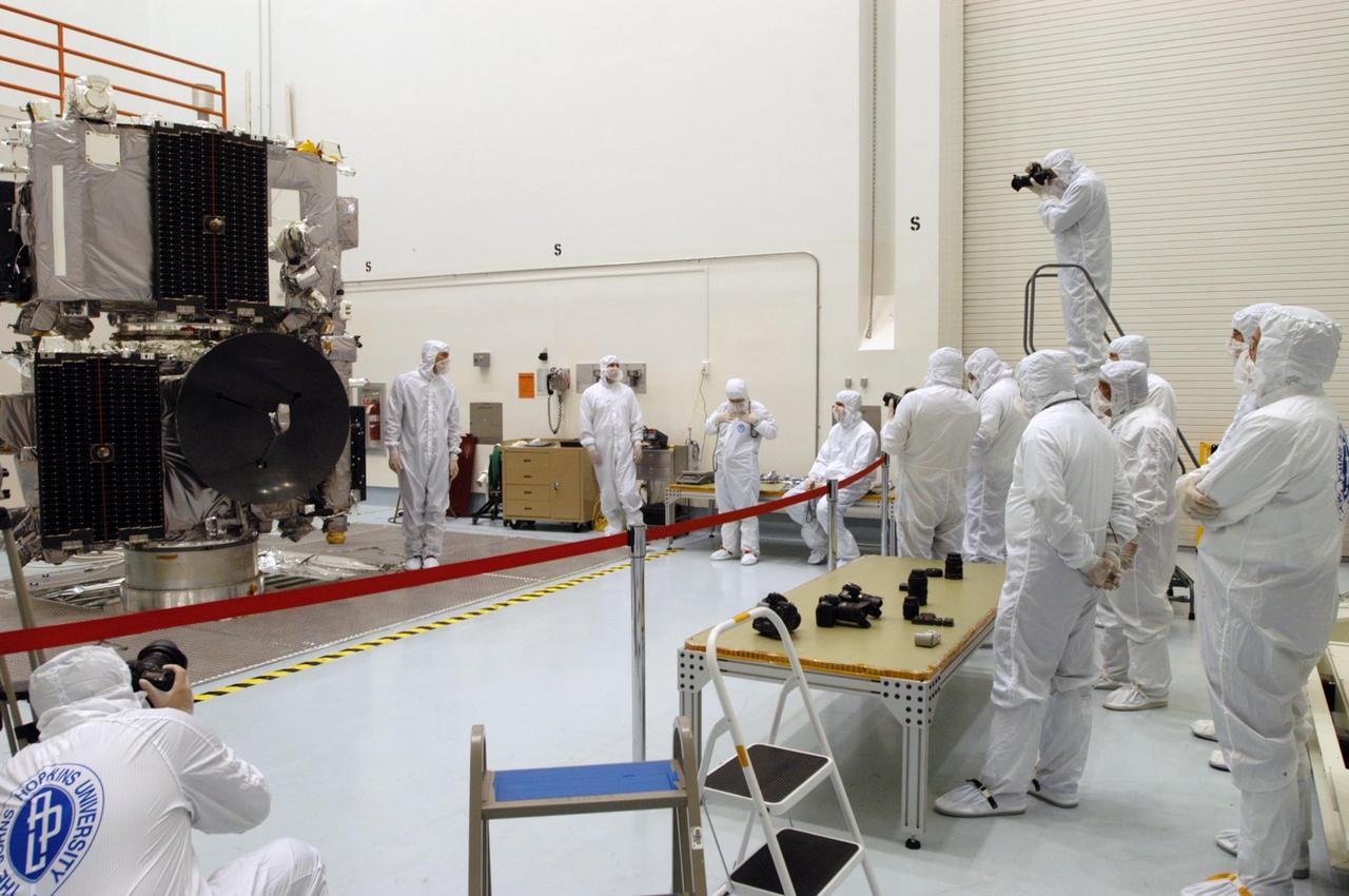
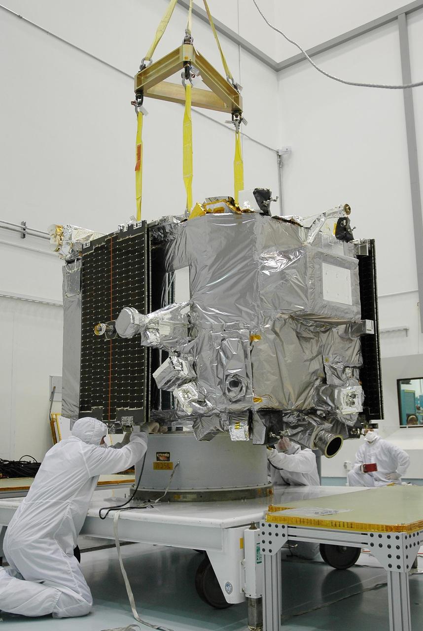
KENNEDY SPACE CENTER, FLA. - At Astrotech Space Operations in Titusville, Fla., workers prepare one of the STEREO observatories that will be lifted and moved. It will be mated to the other observatory, in the background, for launch. STEREO, which stands for Solar Terrestrial Relations Observatory, is the first to take measurements of the sun and solar wind in 3-dimension. This new view will improve our understanding of space weather and its impact on the Earth. STEREO is expected to lift off aboard a Boeing Delta II rocket from Launch Pad 17-B at Cape Canaveral Air Force Station on Aug. 31. Photo credit: NASA/George Shelton
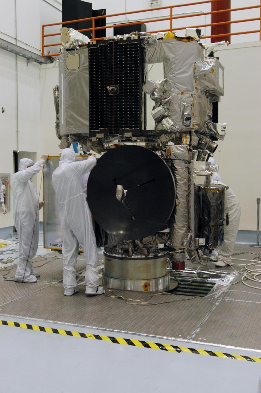
KENNEDY SPACE CENTER, FLA. - The STEREO observatories are the focus of attention at a media viewing held at Astrotech Space Operations in Titusville, Fla., on Aug. 11. The two observatories were mated for launch but will separate into different orbits for their mission. STEREO stands for Solar Terrestrial Relations Observatory. The STEREO mission is the first to take measurements of the sun and solar wind in 3-dimension. This new view will improve our understanding of space weather and its impact on the Earth. STEREO is expected to lift off on Aug. 31, from Launch Pad 17-B on Cape Canaveral Air Force Station in Florida. Photo credit: NASA/George Shelton.
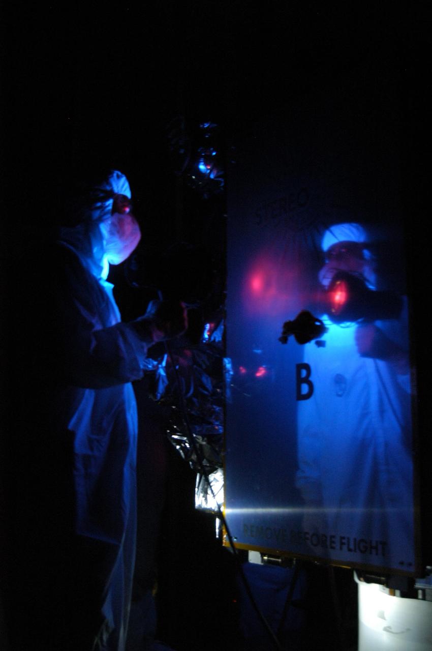
KENNEDY SPACE CENTER, FLA. - At Astrotech Space Operations in Titusville, Fla., technicians perform black-light inspection and cleaning of Observatory B, part of the STEREO spacecraft. The observatory will later be wrapped for transfer to the hazardous processing facility and fueling. STEREO stands for Solar Terrestrial Relations Observatory. The STEREO mission is the first to take measurements of the sun and solar wind in 3-dimension. This new view will improve our understanding of space weather and its impact on the Earth. STEREO is expected to lift off aboard a Boeing Delta II rocket no earlier than Aug. 1. Photo credit: NASA/George Shelton
KENNEDY SPACE CENTER, FLA. - In the hazardous processing facility at Astrotech Space Operations in Titusville, Fla., technicians check Observatory A before lifting onto a scale for weight measurements. The observatory is one of two in the STEREO spacecraft and later will be fueled. STEREO stands for Solar Terrestrial Relations Observatory. The STEREO mission is the first to take measurements of the sun and solar wind in 3-dimension. This new view will improve our understanding of space weather and its impact on the Earth. STEREO is expected to lift off aboard a Boeing Delta II rocket no earlier than Aug. 1. Photo credit: NASA/Jack Pfaller

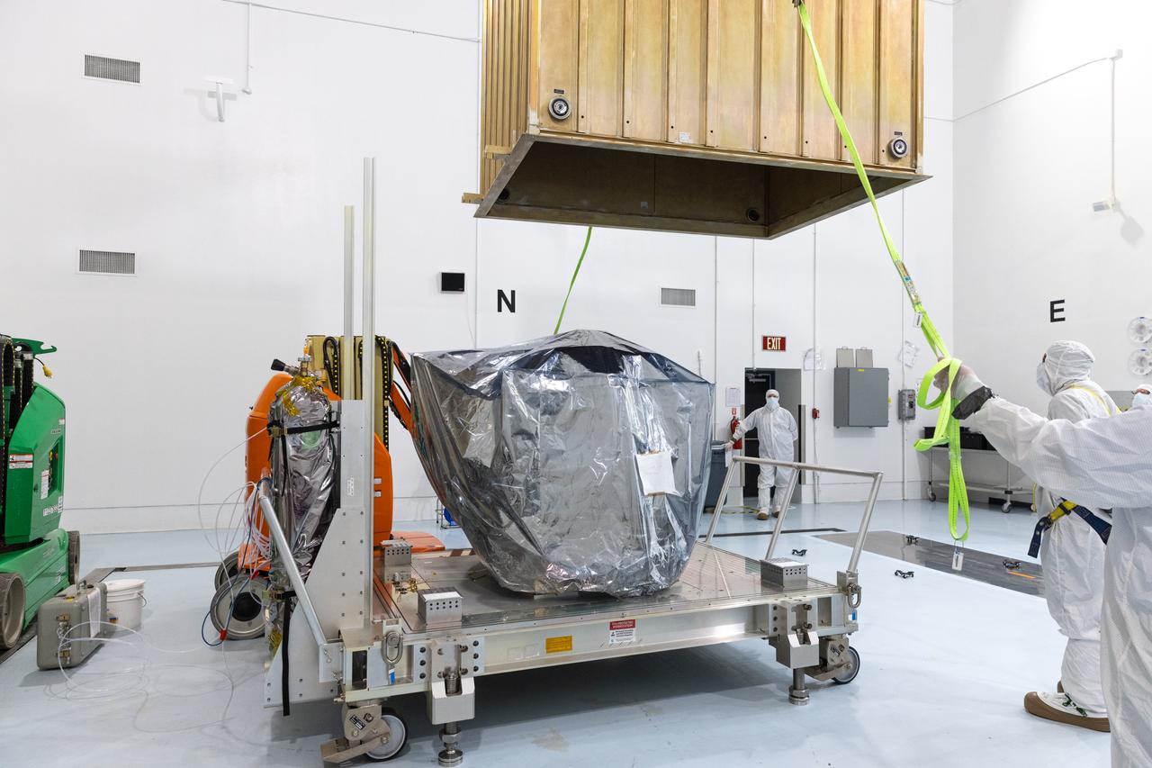
Technicians rotate the National Oceanic and Atmospheric Administration’s (NOAA) Space Weather Follow On–Lagrange 1 (SWFO-L1) Observatory vertically and use a crane to lift it from its transport container on Wednesday, July 23, 2025, following the arrival and unboxing of the observatory at the Astrotech Space Operations Facility near NASA’s Kennedy Space Center in Florida. The SWFO-L1 mission will monitor the Sun and near-Earth environment using a suite of instruments that provide real-time measurements of solar activity. The observatory will launch as a rideshare with NASA’s IMAP (Interstellar Mapping and Acceleration Probe) no earlier than September 2025.
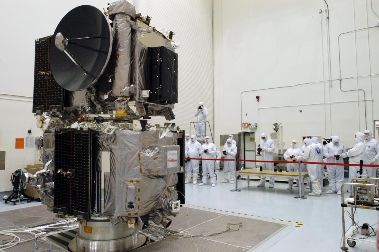
KENNEDY SPACE CENTER, FLA. - The STEREO observatories are the focus of attention at a media viewing held at Astrotech Space Operations in Titusville, Fla., on Aug. 11. The two observatories were mated for launch but will separate into different orbits for their mission. STEREO stands for Solar Terrestrial Relations Observatory. The STEREO mission is the first to take measurements of the sun and solar wind in 3-dimension. This new view will improve our understanding of space weather and its impact on the Earth. STEREO is expected to lift off on Aug. 31, from Launch Pad 17-B on Cape Canaveral Air Force Station in Florida. Photo credit: NASA/George Shelton.
KENNEDY SPACE CENTER, FLA. - The STEREO observatories are the focus of attention at a media viewing held at Astrotech Space Operations in Titusville, Fla. The two observatories were mated for launch but will separate into different orbits for their mission. STEREO stands for Solar Terrestrial Relations Observatory. The STEREO mission is the first to take measurements of the sun and solar wind in 3-dimension. This new view will improve our understanding of space weather and its impact on the Earth. STEREO is expected to lift off on Aug. 31, from Launch Pad 17-B on Cape Canaveral Air Force Station in Florida. Photo credit: NASA/George Shelton.
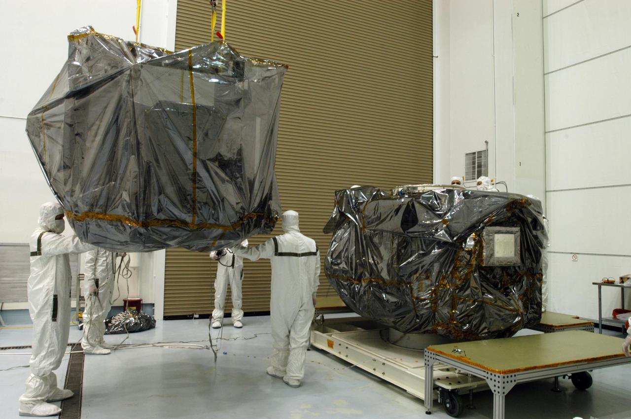
KENNEDY SPACE CENTER, FLA. - At Astrotech Space Operations in Titusville, Fla., one of the STEREO observatories is lifted and moved toward the other observatory, in the background. They will be mated for launch. STEREO, which stands for Solar Terrestrial Relations Observatory, is the first to take measurements of the sun and solar wind in 3-dimension. This new view will improve our understanding of space weather and its impact on the Earth. STEREO is expected to lift off aboard a Boeing Delta II rocket from Launch Pad 17-B at Cape Canaveral Air Force Station on Aug. 31. Photo credit: NASA/George Shelton
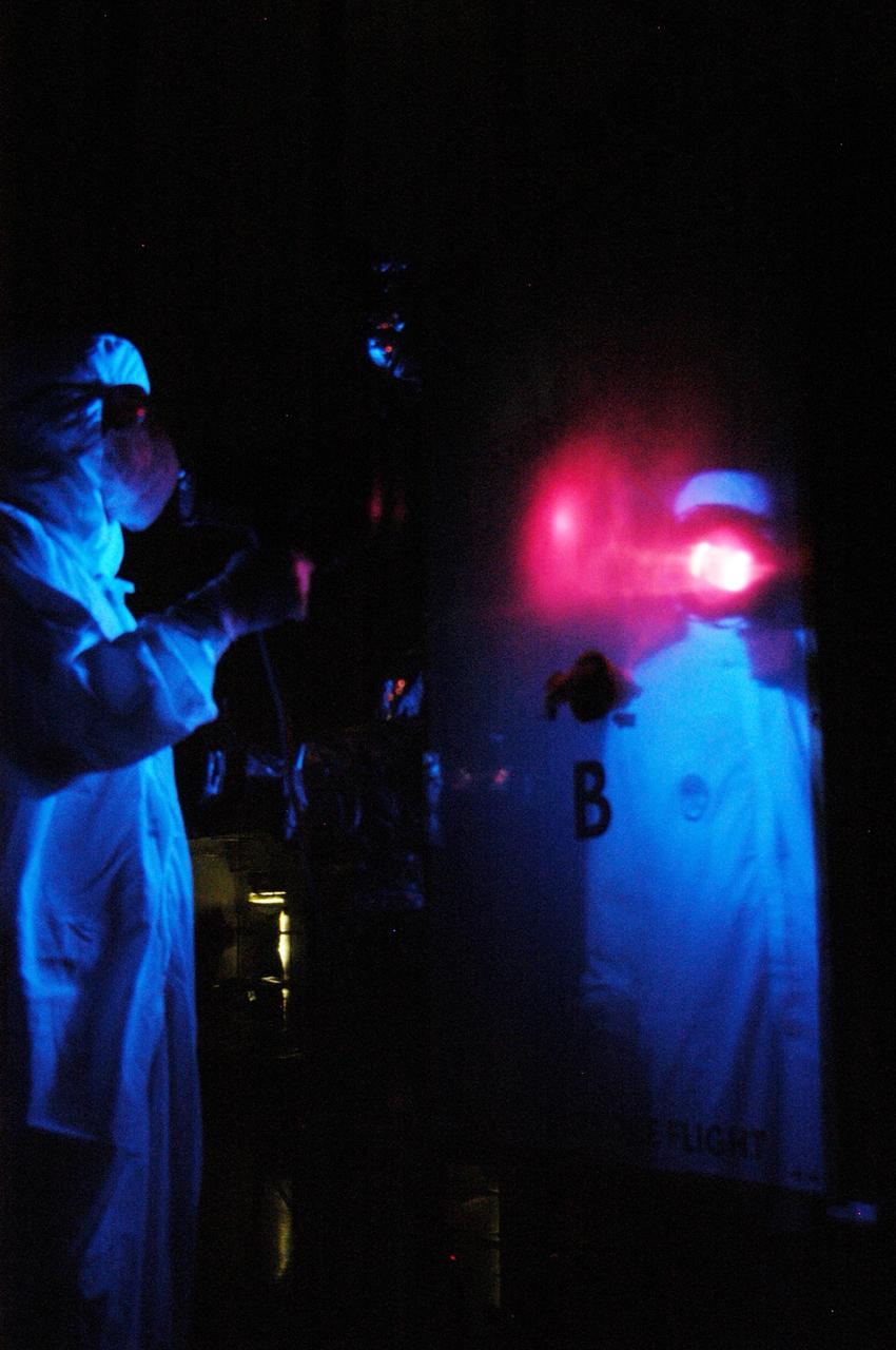
KENNEDY SPACE CENTER, FLA. - At Astrotech Space Operations in Titusville, Fla., technicians perform black-light inspection and cleaning of Observatory B, part of the STEREO spacecraft. The observatory will later be wrapped for transfer to the hazardous processing facility where it will be weighed and fueled. STEREO stands for Solar Terrestrial Relations Observatory. The STEREO mission is the first to take measurements of the sun and solar wind in 3-dimension. This new view will improve our understanding of space weather and its impact on the Earth. STEREO is expected to lift off aboard a Boeing Delta II rocket no earlier than Aug. 1. Photo credit: NASA/George Shelton