
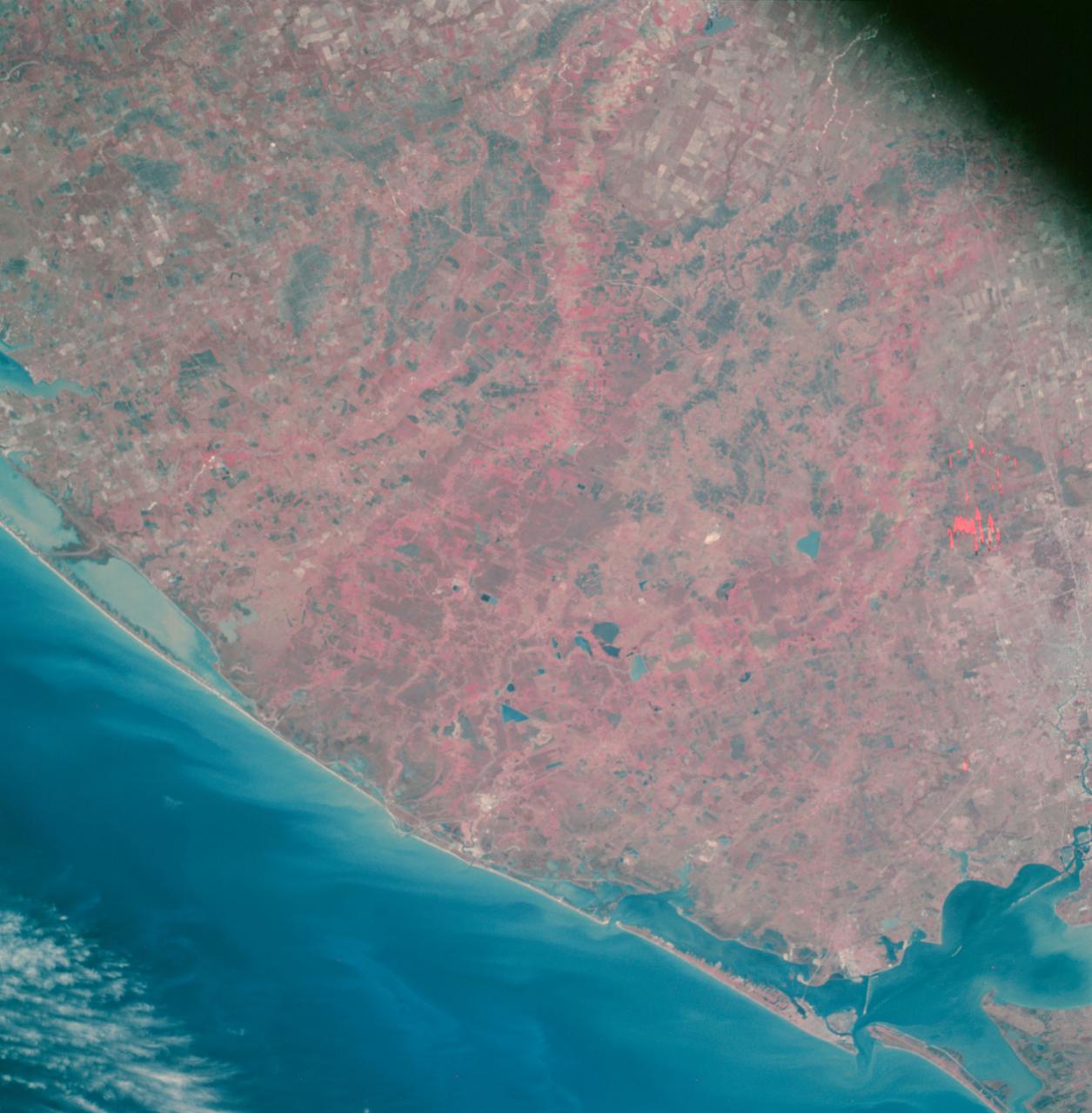
SL4-93-167 (February 1974) --- A vertical view of the Kennedy Space Center and the Florida Atlantic coast area is seen in this Skylab 4 Earth Resources Experiments Package S190-B (five-inch earth terrain camera) infrared photography taken from the Skylab space station in Earth orbit. This photograph shows the major land-ocean features of the Florida coast near Vero Beach northward to Cape Canaveral and the KSC complex. The launch pads for the Skylab missions are clearly visible. Identification of living vegetation is possible through the use of the color infrared film. Various shades of red portray differences in the vegetation such as shown in the patterns in the agricultural area near Vero Beach. In the Kennedy Space Center, the nearly continuous and uniform red color shows that most of the land areas are heavily vegetated. The white coastal beach areas are strongly contrasted to the red land and the blue Atlantic Ocean. Old dunal areas in KSC are visible on Merritt Island which is separated from the Launch areas by the Banana River and the mainland by the Indian River. Federal and state highways and numerous causeways over the rivers are easily identified. The Florida mainland is partly shadowed by small white clouds which cast a pronounced shadow to the east of each cloud indicated the Sun is west of solar noon. Federal agencies participating with NASA on the EREP project are the Departments of Agriculture, Commerce, Interior, the Environmental Protection Agency and the Core of Engineers. All EREP photography is available to the public through the Department of Interior's Earth Resources Observations Systems Data Center, Sioux Falls, South Dakota, 57198. Photo credit: NASA
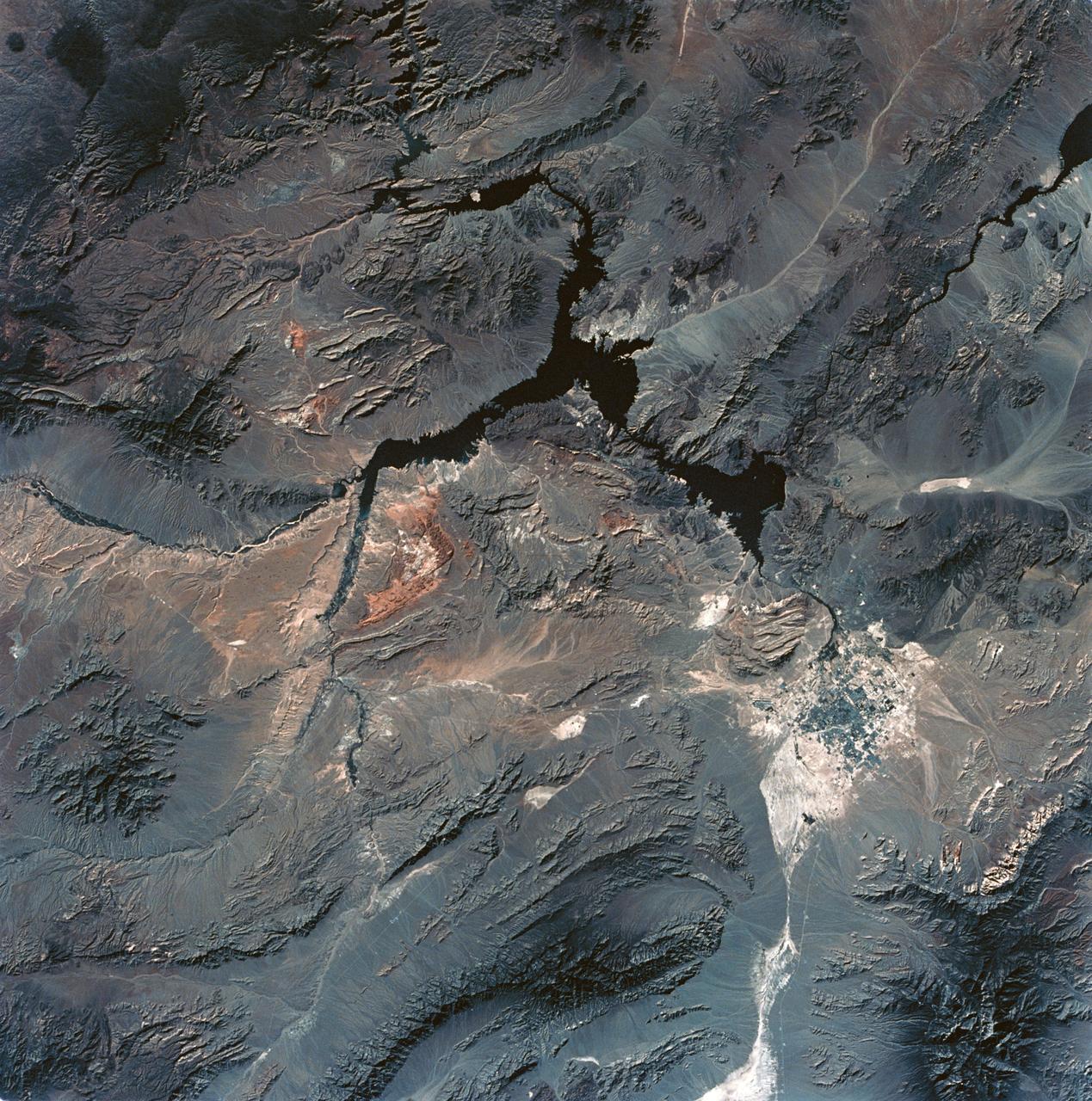
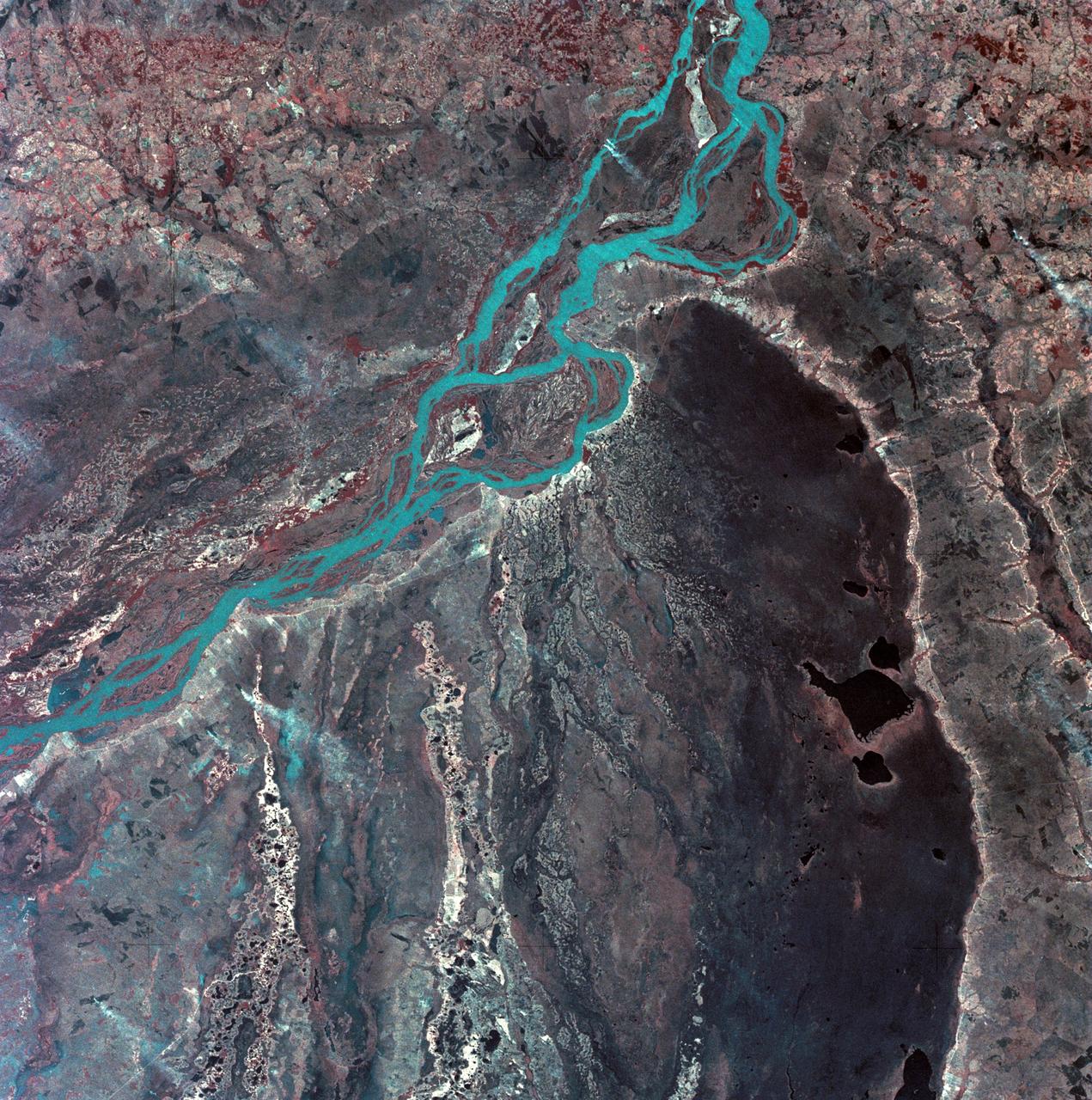
SL3-28-059 (July-September 1973) --- A vertical view of the Lake Mead and Las Vegas, Nevada area as photographed from Earth orbit by one of the six lenses of the Itek-furnished S190-A Multispectral Photographic Facility Experiment aboard the Skylab space station. Lake Mead is water of the Colorado River impounded by Hoover Dam. Most of the land in the picture is Nevada. However, a part of the northwest corner of Arizona can be seen. Federal agencies participating with NASA on the EREP project are the Departments of Agriculture, Commerce, Interior, the Environmental Protection Agency and the Corps of Engineers. All EREP photography is available to the public through the Department of Interior?s Earth Resources Observations Systems Data Center, Sioux Falls, South Dakota, 57198. Photo credit: NASA
SL3-27-224 (July-September 1973) --- A vertical view of the western portion of the Republic of Panama on the Isthmus of Panama as photographed from Earth orbit by one of the six lenses of the Itek-furnished S190-A Multispectral Photographic Facility Experiment aboard the Skylab space station. This picture was taken with 2443 infrared color film. The large, clear body of water on the north side of the isthmus is Golfo de los Mosquitos, an extension of the Caribbean Sea. The large, partly cloud-covered body of water on the south side of the isthmus is Golfo de Chiriqui, an extension of the Pacific Ocean. Federal agencies participating with NASA on the EREP project are the Department of Agriculture, Commerce, Interior, the Environmental Protection Agency and the Corps of Engineers. All EREP photography is available to the public through the Department of Interior?s Earth Resources Observation Systems Data Center, Sioux Falls, South Dakota, 57198. Photo credit: NASA

SL3-22-0214 (July-September 1973) --- A vertical view of southeastern Washington State as photographed from Earth orbit by one of the six lenses of the Itek-furnished S190-A Multispectral Photographic Facility Experiment aboard the Skylab space station. The Snake River flows into the Columbia River in the most southerly corner of the picture. The Wallula Lake is below the junction of the two rivers. The Yakima Valley is at the southwestern edge of the photograph. The Columbia Basin is in the center of the picture. The Cascade Range extends across the northwest corner of the photograph. This picture was taken with type SO-356 regular color film. The S190-A experiment is part of the Earth Resources Experiments Package. Federal agencies participating with NASA on the EREP project are the Departments of Agriculture, Commerce, Interior, the Environmental Protection Agency and the Corps of Engineers. All EREP photography is available to the public through the Department of Interior?s Earth Resources Observations Systems Data Center, Sioux Falls, South Dakota, 57198. Photo credit: NASA

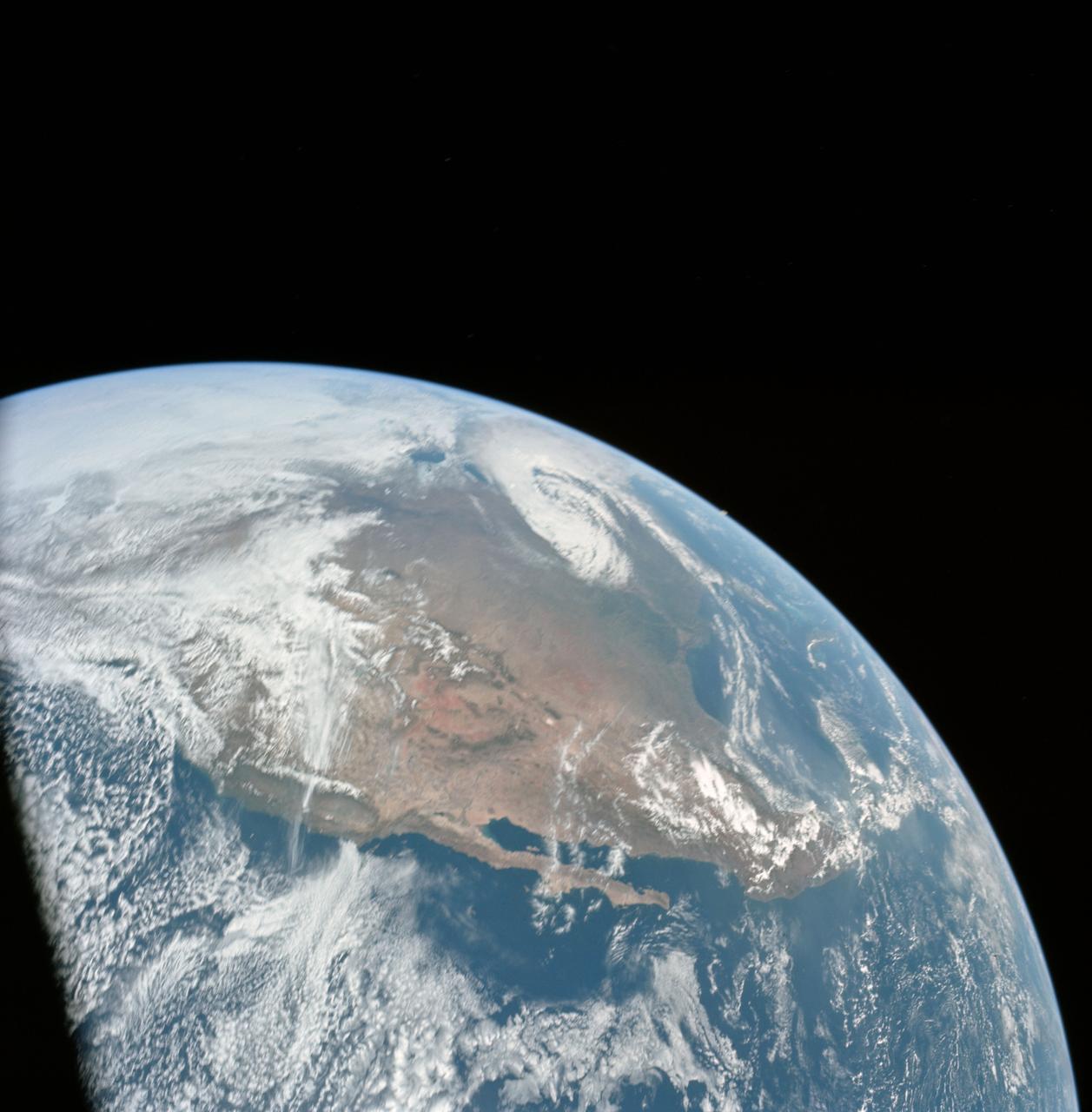
SL3-40-077 (July-September 1973) --- A vertical view of the Mediterranean coastal area of southeastern France as photographed from Earth orbit by one of the six lenses of the Itek-furnished S190-A Multispectral Photographic Facility Experiment aboard the Skylab space station. This view of the coast extends from the eastern outskirts of Marseilles easterly to Cannes, and includes the city of Toulon. The S190-A experiment is part of the Skylab Earth Resources Experiments Package. Federal agencies participating with NASA on the EREP project are the Departments of Agriculture, Commerce, Interior, the Environmental Protection Agency and the Corps of Engineers. All EREP photography is available to the public through the Department of Interior?s Earth Resources Observations Systems Data Center, Sioux Falls, South Dakota, 57198. Photo credit: NASA
SL3-22-0322 (July-September 1973) --- An oblique view of the Salt Lake City, Utah area as photographed from Earth orbit by one of the six lenses of the Itek-furnished S190-A Multispectral Photographic Facility Experiment aboard the Skylab space station. Approximately two-thirds of the Great Salt Lake is in view. The smaller body of water south of Salt Lake City is Utah Lake. The Wasatch Range is on the east side of the Great Salt Lake. Federal agencies participating with NASA on the EREP project are the Departments of Agriculture, Commerce, Interior, the Environmental Protection Agency and the Corps of Engineers. All EREP photography is available to the public through the Department of Interior?s Earth Resources Observations Systems Data Center, Sioux Falls, South Dakota, 57198. Photo credit: NASA
SL3-27-180 (July-September 1973) --- A vertical view of the Snowy Mountains area of Australian Alps in the States of Victoria and New South Wales, Australia, as photographed from Earth orbit by one of the six lenses of the Itek-furnished S190-A Multispectral Photographic Facility Experiment aboard the Skylab space station. This picture was taken with type 2443 infrared color film. The lake near the center of the picture is the Eucumbene Reservoir. This area is located immediately south-southwest of the capital city of Canberra. Federal agencies participating with NASA on the EREP project are the Departments of Agriculture, Commerce, Interior, the Environmental Protection Agency and the Corps of Engineers. All EREP photography is available to the public through the Department of Interior?s Earth Resources Observations Systems Data Center, Sioux Falls, South Dakota, 57198. Photo credit: NASA
SL3-45-020 (July-September 1973) --- A vertical view of the Virginia-Tennessee-Kentucky border area as photographed from Earth orbit by one of the six lenses of the Itek-furnished S190-A Multispectral Photographic Facility Experiment aboard the Skylab space station. This picture was taken with type 2443 infrared color film. The S190-A experiment is part of the Skylab Earth Resources Experiments Package. The long, narrow ridge is Pine Mountain; and it is crossed by U.S. 25E at Pineville near its southernmost end. Some 25 miles south of Pineville U.S. 25E passes through the famed Cumberland Gap which at 1,600 feet elevation crosses Cumberland Mountain. Kingsport, Tennessee is located east of Cumberland Gap near the center of the picture. Bristol, Tennessee-Virginia is further east. Greenville and Elizabethton, Tennessee can also be seen in this photograph. The clouds across the southeast edge of the picture are over the Blue Ridge Mountains. Federal agencies participating with NASA on the EREP project are the Departments of Agriculture, Commerce, Interior, the Environmental Protection Agency and the Corps of Engineers. All EREP photography is available to the public through the Department of Interior?s Earth Resources Observations Systems Data Center, Sioux Falls, 57198. Photo credit: NASA
SL3-33-167 (July-September 1973) --- A vertical view of the Argentina-Paraguay border area of South America as photographed from Earth orbit by one of the six lenses of the Itek-furnished S190-A Multispectral Photographic Facility Experiment aboard the Skylab space station. This picture was taken with type 2443 infrared color film. The Parana River flows from east to west across the picture. This part of the Rio Parana is located between the towns of Posadas, Argentina, and Resistencia, Argentina. The major body of water in the large swamp area is Laguna Ibera. Note the several fires burning in this area. The largest land mass (Argentina) is south of the river. Paraguay is north of the river. Isla Apipe Grande is near the center of the photograph. The S190-A experiment is part of the Skylab Earth Resources Experiments Package. Federal agencies participating with NASA on the EREP project are the Departments of Agriculture, Commerce, Interior, the Environmental Protection Agency and the Corps of Engineers. All EREP photography is available to the public through the Department of Interior?s Earth Resources Observations Systems Data Center, Sioux Falls, South Dakota, 57198. Photo credit: NASA
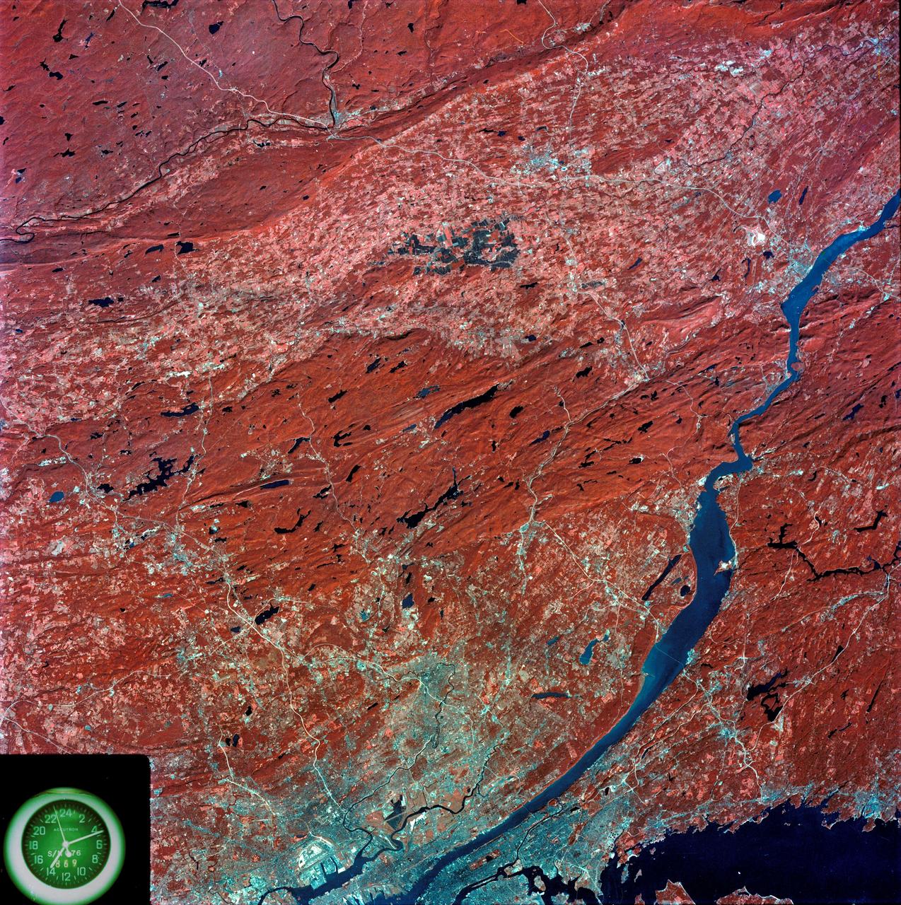
SL3-87-299 (July-September 1973) --- A vertical view of southeastern New York State is seen in this Skylab 3 Earth Resources Experiments Package S190-B (five-inch Earth terrain camera) infrared photograph taken from the Skylab space station in Earth orbit. An 18-inch, 450mm lens and type 2443 infrared Ektachrome film was used. This picture covers the northern part of New Jersey, a part of northwestern Pennsylvania, and the western tip of Connecticut. The body of water is Long Island Sound. The wide Hudson River flows southward across a corner of the photograph. The New York City metropolitan area occupies part of the picture. Federal agencies participating with NASA on the EREP project are the Departments of Agriculture, Commerce, Interior, the Environmental Protection Agency and the Corps of Engineers. All EREP photography is available to the public through the Department of Interior?s Earth Resources Observations Systems Data Center, Sioux Falls, South Dakota, 57198. Photo credit: NASA
iss058e002448 (Jan. 9, 2019) --- Expedition 58 Commander Oleg Kononenko of Roscosmos is pictured inside the Pirs docking compartment during operations to install gear for the VIZIR earth observation experiment. The study tests the technology of automated coordinate referencing of images of the Earth’s surface, and space, taken by crew members using “free-floating” photography equipment in weightlessness. Credit: Roscosmos

SL3-33-156 (July-September 1973) --- A near vertical view of the Florence, Italy area as photographed from Earth orbit by one of the Itek-furnished S190-A Multispectral Photographic Facility Experiment aboard the Skylab space station. The view extends from the Ligurian Sea, an extension of the Mediterranean Sea, across the Apennine Mountains to the Po River Valley. Florence (Firenze) is near the center of the land mass. The mouth of the Arno River is at the center of the coastline. The city of Leghorn (Livorno) is on the coast just south of the Arno River. This picture was taken with type 2443 infrared color film. The S190-A experiment is part of the Skylab Earth Resources Experiments Package. Federal agencies participating with NASA on the EREP project are the Department of Agriculture, Commerce, Interior, the Environmental Protection Agency and the Corps of Engineers. All EREP photography is available to the public through the Department of Interior?s Earth Resources Observations Systems Data Center, Sioux Falls, South Dakota, 57198. Photo credit: NASA
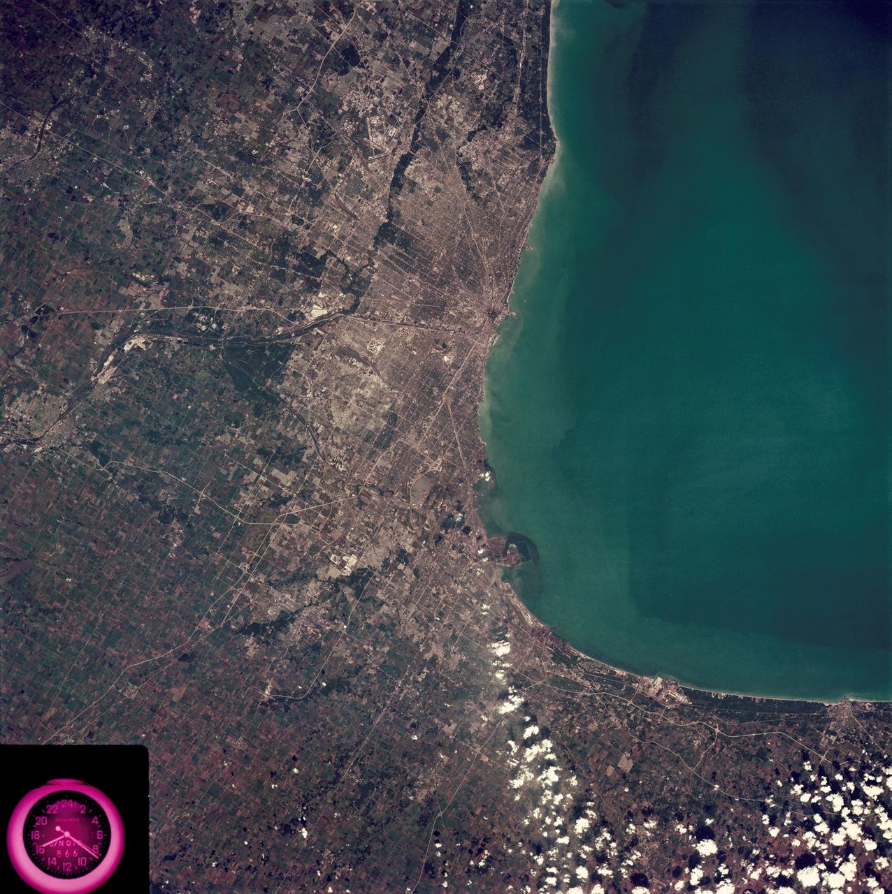
SL3-88-222 (18 Sept. 1973) --- The metropolitan area of Chicago is encompassed in this Skylab 3 Earth Resources Experiments Package (EREP) S190-B photograph taken on Sept. 18, 1973 from the Skylab space station cluster in Earth orbit. The surrounding major cities of Aurora and Joliet, Illinois; Hammond, Gary and East Chicago, Indiana, are easily delineated. The photograph reveals the following: (1) Cultural differentiation of commercial, industrial and residential areas for use in population and social studies in micro-macro community planning and in cultural pattern studies in the improvement of urban areas. (Aurora is one of 27 census cities of interest to Robert Alexander, a principal investigator. Alexander is with the U.S. Geological Survey). (2) The transportation network with major corridors and their interchanges, primary and feeder streets for use in network analysis and in the development of models for population movement and land use projection. (3) The agricultural lands for land use identification on crop inventory analysis; airports for use in delineation of service and infringement of major man-made features that affect ecosystem balance (support to environmental impact studies). (4) Air and water plumes for use in case studies, natural and man-made differentiation of pollution sources, in support of model development and in ecosystem research studies on the effects of pollution. (5) Recreational centers for use in relating recreational centers to population centers, establishing possible demands and in development of possible future recreational centers to support the demand. All EREP photography is available to the public through the Department of Interior?s Earth Resources Observations Systems Data Center, Sioux Falls, South Dakota, 57198. Photo credit: NASA
SL3-88-004 (July-September 1973) --- A vertical view of the Salinas River Valley area south of Monterey Bay, California area is seen in this Skylab 3 Earth Resources Experiments Package S190-B (five-inch Earth terrain camera) photograph taken from the Skylab space station in Earth orbit. The valley is an irrigated agricultural area, and is indicated by the dark-green and light-gray rectangular patterns in the centre of the picture. The city of Salinas is barely visible under the cloud cover at the top (north) end of the valley. The dark mass on the left (west) side of the valley is the Santa Lucia mountain range. The Big Sur area is on the left and partly covered by clouds. The Diablo Range forms the dark mass in the lower right (southeast) corner of the photograph. The town of Hollister is the gray area in the dark-green rectangular farm tracts which occupy the floor of the San Benito Valley in the upper right (northeast) corner of the photograph. The Salinas River flows northwestward toward Monterey Bay. The towns of Soledad, Greenfield and King City appear as gray areas along U.S. 101 in the Salinas Valley. The geology of the area is complex, and has been racked by several earthquakes resulting from movement along the San Andreas and subsidiary faults. Here, the surface expression of the San Andreas Fault can be traced from a point just west of Hollister at the contrast of dark brown and tan to a point about one inch left of the lower right (southeast) corner of the picture. Subsidiary faults are indicated by the curving trend of the rocks along the right side. The photograph will provide detailed information on land use patterns (Dr. R. Colwell, University of California, Berkeley) and fault tectonics (Dr. P. Merifield, Earth Science Res., Inc. and Dr. M. Abdel-Gawad, Rockwell International). Federal agencies participating with NASA on the EREP project are the Departments of Agriculture, Commerce, Interior, the Environmental Protection Agency and the Corps of Engineers. All EREP photography is available to the public through the Department of Interior’s Earth Resources Observations Systems Data Center, Sioux Falls, South Dakota, 57198. Photo credit: NASA

SL4-93-153 (February 1974) --- A vertical view of the Birmingham and central Alabama area is seen in this Skylab 4 Earth Resources Experiments Package S190-B (five-inch earth terrain camera) infrared photographed taken from the Skylab space station in Earth orbit. Illustrated here is the utility of color infrared film in depicting distribution of living vegetation in the 3,600 square mile Birmingham region. The Birmingham industrial complex, with a population of nearly 850,000, is the light gray area nestled in the valley between the northeast-trending ridges that are prominent topographic features in the southern Appalachian Mountains. The narrow ridges and adjacent valleys reflect folded and faulted sedimentary rocks, indicating the complex geological history of the region. Two major rivers and several reservoirs are easily distinguished in this photograph. Bankhand Lake, formed by a dam on the Black Warrior River, appears as bright blue west of Birmingham. Two lakes are formed by dams on the Goosa River east of Birmingham. Federal and state highways appear as thin white lines and are easily identified. Interstate 65 to Montgomery is the prominent white line extending southward from Birmingham. Power line clearings are visible in the center of the picture along the Goosa River, and can be traced northwestward to northern parts of Birmingham. The predominant deep red color of the picture is due to the reflections from living vegetation. In contrast are the light tan areas that commonly occur as rectangular patterns in the east part of the photograph and represent mature agricultural crops or grazing lands. Analysis of the photographic data from the earth terrain camera will be conducted by Dr. H. Jayroe of the Marshall Space Flight Center in developing analytical techniques. All EREP photography is available to the public through the Department of Interior's Earth Resources Observations Systems Data Center, Sioux Falls, South Dakota, 57198. Photo credit: NASA
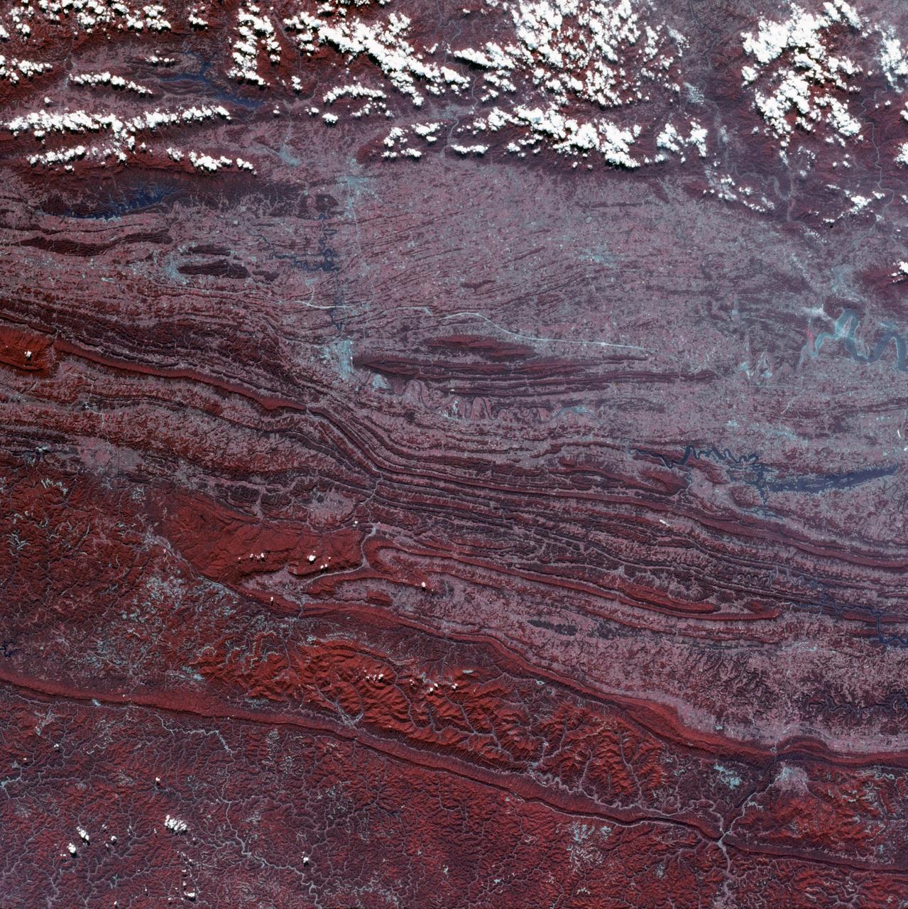
SL3-88-053 (July-September 1973) --- A near vertical view of the Tennessee-Virginia-Kentucky border area is seen in this Skylab 3 Earth Resources Experiments Package S190-B (five-inch Earth terrain camera) photograph taken from the Skylab space station in Earth orbit. The clock is in the most southerly corner of the picture. Interstate 81 under construction extends northeast-southwest across the bottom portion of the photograph. The larger urban area nearest the center of the picture is Kingsport, Tennessee. On the southern side of I-80 and east of Kingsport is the city of Bristol, Tennessee-Virginia. Johnson City, Tennessee is the urban area near the edge of the picture southeast of Kingsport. The Holston River, a tributary of the Tennessee River, meanders through the Kingsport area. The characteristic ridge and valley features in the Cumberland Plateau of Kentucky, Tennessee and Virginia are clearly visible. Forests (dark green) occur on the ridges and clearly outline the folded and faulted rock formations. The valleys (light) were formed in the softer rocks as a result of erosion. Agricultural areas are indicated by the characteristic rectangular patterns. Coal production is an important industry of this area; and it is mined by surface open pit operations. The irregular light areas in the Kentucky-Virginia border area are the strip mines which follow the contour of the land. Reclamation of the strip mine areas is aided through accurate knowledge of the mine and drainage systems. Dr. Ronald Brooks of the Wolf Research and Development Corporation can use this photograph in study of strip mine areas in the east central U.S. Federal agencies participating with NASA on the EREP project are the Departments of Agriculture, Commerce, Interior, the Environmental Protection Agency and the Corps of Engineers. All EREP photography is available to the public through the Department of Interior’s Earth Resources Observations Systems Data Center, Sioux Falls, South Dakota, 57198. Photo credit: NASA

SL3-87-355 (July-September 1973) --- A vertical view of the eastern coast of Sicily area is seen in this Skylab 3 Earth Resources Experiments Package S190-B (five-inch earth terrain camera) infrared photograph taken from the Skylab space station in Earth orbit. Mount Etna, the highest volcano in Europe (10,958 feet), is still active as evidenced by the thin plume of smoke emanating from its crest. (The altitude is approximate because the height of the volcano changes with each eruption). On the flanks of Etna recent lava flows appear black in contrast to the older flows and volcanic debris that are red. Numerous small, circular cinder cones on the flanks represent sites of previous eruptions. Catania, on the Mediterranean coast south of Etna, is the largest of several cities and villages which appear as light-gray patches on the lower slopes of the volcano. Plano de Catania, south of the city of Catania, is outlined by polygonal light and dark agricultural tracts. Several lakes, the largest of which is Lake Pozzillo, show up as dark blue in the photograph. The unusual colors in the picture are due to the use of color infrared film in which vegetation appears red. This is very evident on the slopes of Etna, in the Monti Nebrodi area at upper let, and in the local areas in the lower part of the picture. Studies of Mount Etna and related volcanic features will be undertaken by Professor Roberto Cassinis of Servizio Geologio d?Italia, Rome. Federal agencies participating with NASA on the EREP project are the Departments of Agriculture, Commerce, Interior, the Environmental Protection Agency and the Corps of Engineers. All EREP photography is available to the public through the Department of Interior?s Earth Resources Observation Systems Data Center, Sioux Falls, South Dakota, 57198. Photo credit: NASA
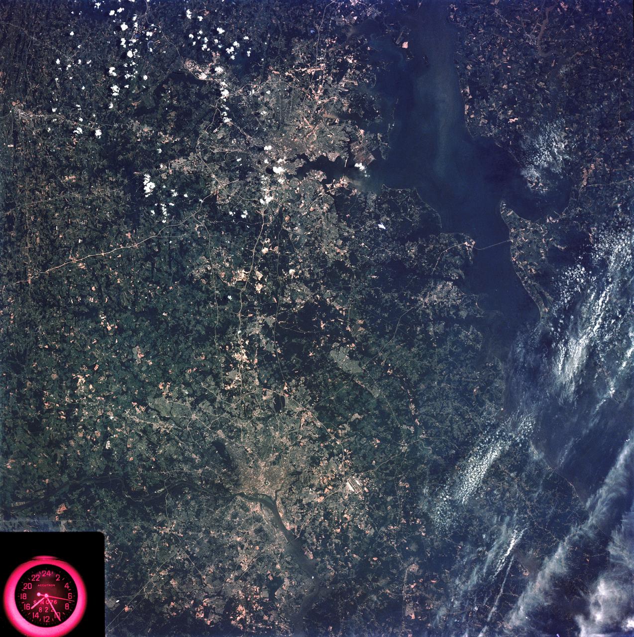
SL3-83-166 (July-September 1973) --- A vertical view of the Washington D.C. and the Baltimore, Maryland area is seen in the Skylab 3 Earth Resources Experiments Package S190-B (five-inch Earth terrain camera) photograph taken from the Skylab space station in Earth orbit. The Chesapeake Bay is on the right (east) side of the picture. The Potomac River flows through the Washington area in the lower left (southwest) corner of the photograph. Several transportation routes and major highways stand out very distinctly. Especially conspicuous are the beltways around the cities, Interstate 95 between Baltimore and the nation?s capitol and Interstate 70N leading west from Baltimore. The tunnel and harbor facilities in Baltimore show clearly, also. Identifiable features in the Washington area include the Capitol Building, the Mall area, Robert F. Kennedy Stadium (white circle), the five bridges across the Potomac, Andrews Air Force Base (on east loop), and the smaller Anacostia River. The extent of the urbanization in this area is dramatically illustrated in this picture. The photograph has sufficient resolution that the housing patterns for individual suburban areas are clearly defined with the houses shown as pink gray, wooded areas as dark green and cleared areas light green. Chesapeake Bay circulation patterns are indicated by contrast of dark and light blue. Sediment plumes (red) are seen entering the bay north and east of Baltimore. The bay bridge stands out white against the blue water. The detailed information contained in this one photograph will be of direct use to several EREP investigator teams in land use analysis, sedimentation and circulation patterns in the bay, and resource surveys of Maryland. All EREP photography is available to the public through the Department of Interior?s Earth Resources Observations Systems Data Center, Sioux Falls, South Dakota, 57198. Photo credit: NASA
SL4-92-300 (February 1974) --- A near vertical view of the Mobile Bay, Alabama area is seen in this Skylab 4 Earth Resources Experiments Package S190-B (five-inch earth terrain camera) photograph taken from the Skylab space station in Earth orbit. North of Mobile the Tombigbee and Alabama Rivers join to form the Mobile River. Detailed configuration of the individual stream channels and boundaries can be defined as the Mobile River flows into Mobile Bay, and thence into the Gulf of Mexico. The Mobile River Valley with its numerous stream channels is a distinct light shade in contrast to the dark green shade of the adjacent areas. The red coloration of Mobile Bay reflects the sediment load carried into the Bay by the rivers. Variations in red color indicate sediment load and the current paths within Mobile Bay. The waterly movement of the along shore currents at the mouth of Mobile Bay is shown by the contrasting light blue of the sediment-laden current and the blue of the Gulf predominately. Agricultural areas east and west of Mobile Bay are characterized by a rectangular pattern in green to white shades. Color variations may reflect the type and growth cycle of crops. Agricultural areas (light gray-greens) are also clearly visible in other parts of the photograph. Interstate 10 extends from near Pascagoula, Mississippi eastward through Mobile to the outskirts of Pensacola, Florida. Analysis of the EREP photographic data will be undertaken by the U.S. Corps of Engineers to determine bay dynamic processes. Federal agencies participating with NASA on the EREP project are the Departments of Agriculture, Commerce, Interior, the Environmental Protection Agency and the Corps of Engineers. All EREP photography is available to the public through the Department of Interior's Earth Resources Observations Systems Data Center, Sioux Falls, South Dakota. 57198 Photo credit: NASA
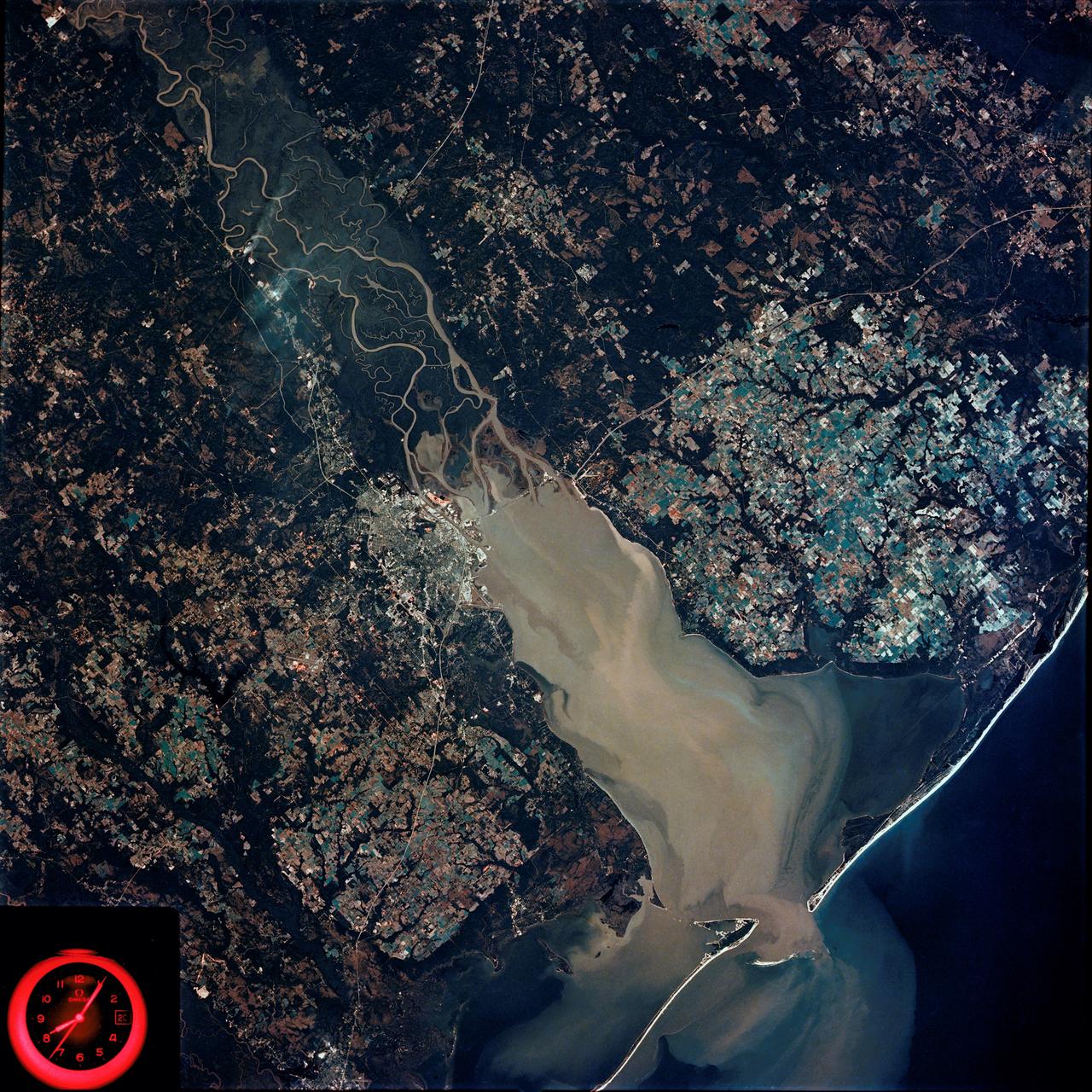
Earth Observation taken by the Apollo 9 crew. View is of Galveston and Freeport in Texas. Latitude was 28.42 N by Longitude 94.54 W, Overlap was 80%, Altitude miles were 105 and cloud cover was 5%. This imagery taken as part of the NASA S0-65 Experiment "Multispectral Terrain Photography". The experiment provides simultaneous satellite photography of the Earth's surface in three distinct spectral bands. The photography consists of four almost spatially identical photographs. The images of ground objects appear in the same coordinate positions on all four photos in the multispectral set within the opto-mechanical tolerances of the Hasselblad cameras in the Apollo 9 spacecraft. Band designation for this frame is A. Film and filter is Ektachrome SO-368,Infrared Color Wratten 15. Mean Wavelength of Sensitivity is green,red and infrared. The Nominal Bandpass is total sensitivity of all dye layers 510-900nm.
Earth Observation taken by the Apollo 9 crew. View is of Salton Sea and Imperial Valley in California. Latitude was 33.09 N by Longitude 116.14 W, Overlap was 50%, Altitude miles were 103 and cloud cover was 35%. This imagery taken as part of the NASA S0-65 Experiment "Multispectral Terrain Photography". The experiment provides simultaneous satellite photography of the Earth's surface in three distinct spectral bands. The photography consists of four almost spatially identical photographs. The images of ground objects appear in the same coordinate positions on all four photos in the multispectral set within the opto-mechanical tolerances of the Hasselblad cameras in the Apollo 9 spacecraft. Band designation for this frame is A. Film and filter is Ektachrome SO-368,Infrared Color Wratten 15. Mean Wavelength of Sensitivity is green,red and infrared. The Nominal Bandpass is total sensitivity of all dye layers 510-900nm.
Earth Observation taken by the Apollo 9 crew. View is of Carrizozo in New Mexico and includes lava flow and snow. Latitude was 33.42 N by Longitude 106.10 W, Overlap was 7.5%, Altitude miles were 121 and cloud cover was 0%. This imagery taken as part of the NASA S0-65 Experiment "Multispectral Terrain Photography". The experiment provides simultaneous satellite photography of the Earth's surface in three distinct spectral bands. The photography consists of four almost spatially identical photographs. The images of ground objects appear in the same coordinate positions on all four photos in the multispectral set within the opto-mechanical tolerances of the Hasselblad cameras in the Apollo 9 spacecraft. Band designation for this frame is A. Film and filter is Ektachrome SO-368,Infrared Color Wratten 15. Mean Wavelength of Sensitivity is green,red and infrared. The Nominal Bandpass is total sensitivity of all dye layers 510-900nm.

iss065e110749 (June 14, 2021) --- Expedition 65 Commander Akihiko Hoshide of the Japan Aerospace Exploration Agency (JAXA) is pictured inside the cupola, the International Space Station's "window to the world," during Earth photography activities.
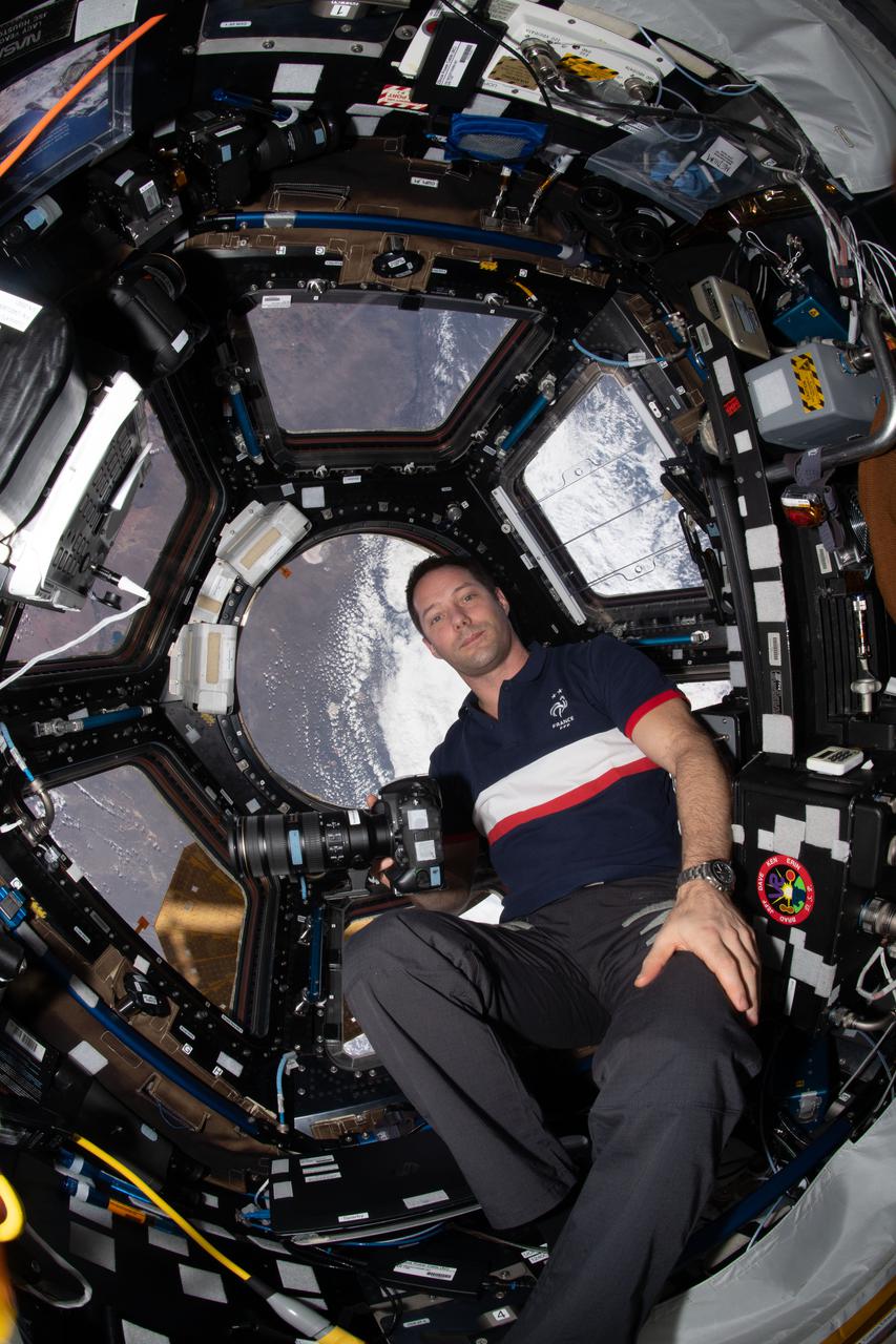
iss065e389253 (Sept. 19, 2021) --- Expedition 65 Flight Engineer Thomas Pesquet of ESA (European Space Agency) is pictured during Earth photography activities inside the seven-windowed cupola, the International Space Station's "window to the world."

iss062e141186 (March 10, 2020) ---NASA astronauts and Expedition 62 Flight Engineers Andrew Morgan and Jessica Meir participate in Earth photography activities inside the Destiny laboratory module's Window Observation Research Facility.

iss068e021032 (Nov. 7, 2022) --- Roscosmos cosmonaut and Expedition 68 Flight Engineer Anna Kikina prepares camera equipment for an Earth photography session through a hatch window on the International Space Station's Harmony module.
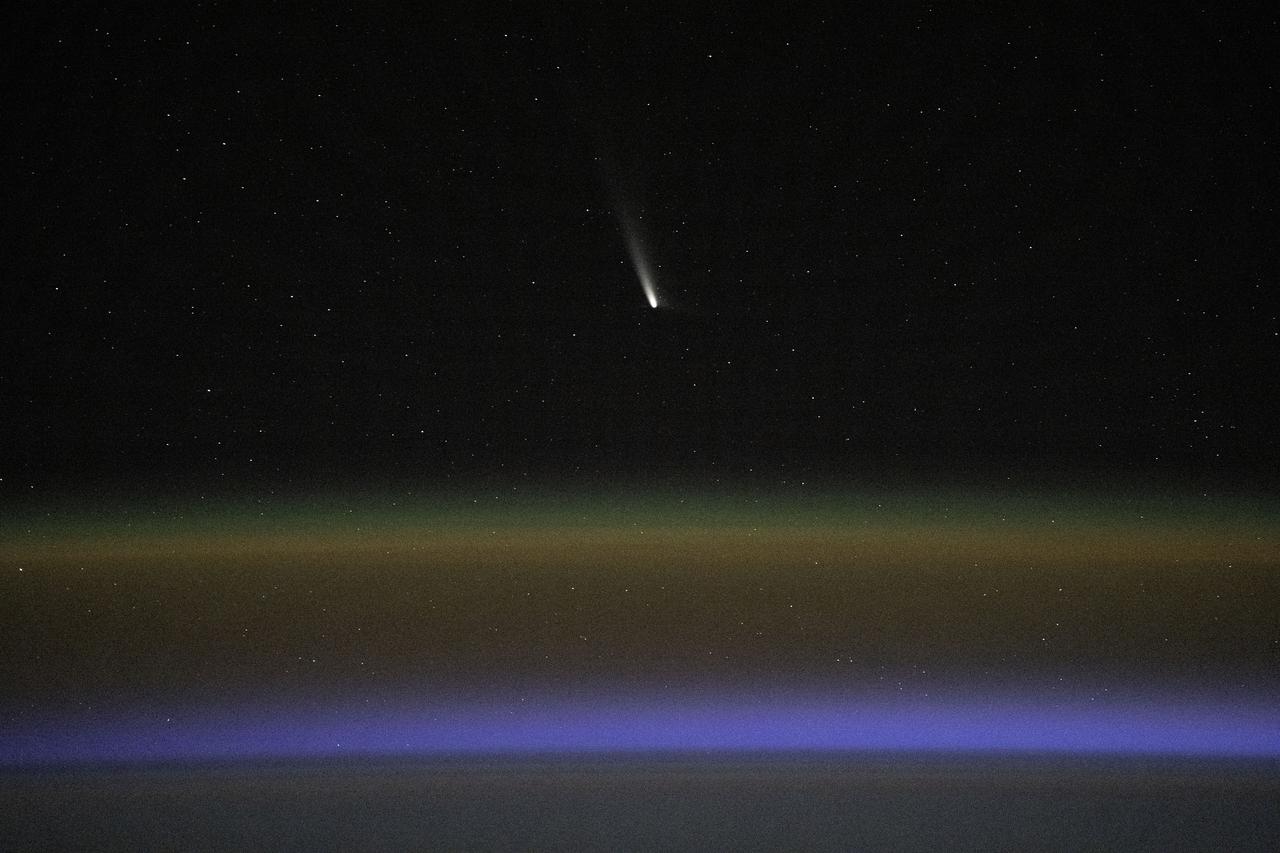
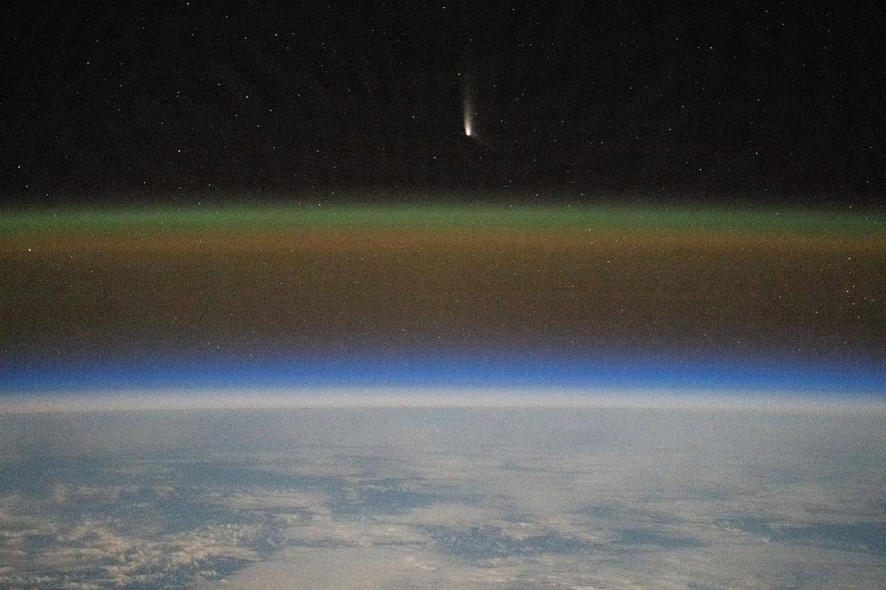
iss071e700447 (Sept. 22, 2024) --- Comet C2023-A3, or Tsuchinshan-ATLAS, was pictured about 99.4 million miles away from Earth by NASA astronaut Matthew Dominick using long-duration photography on a camera programmed for high sensitivity aboard the International Space Station
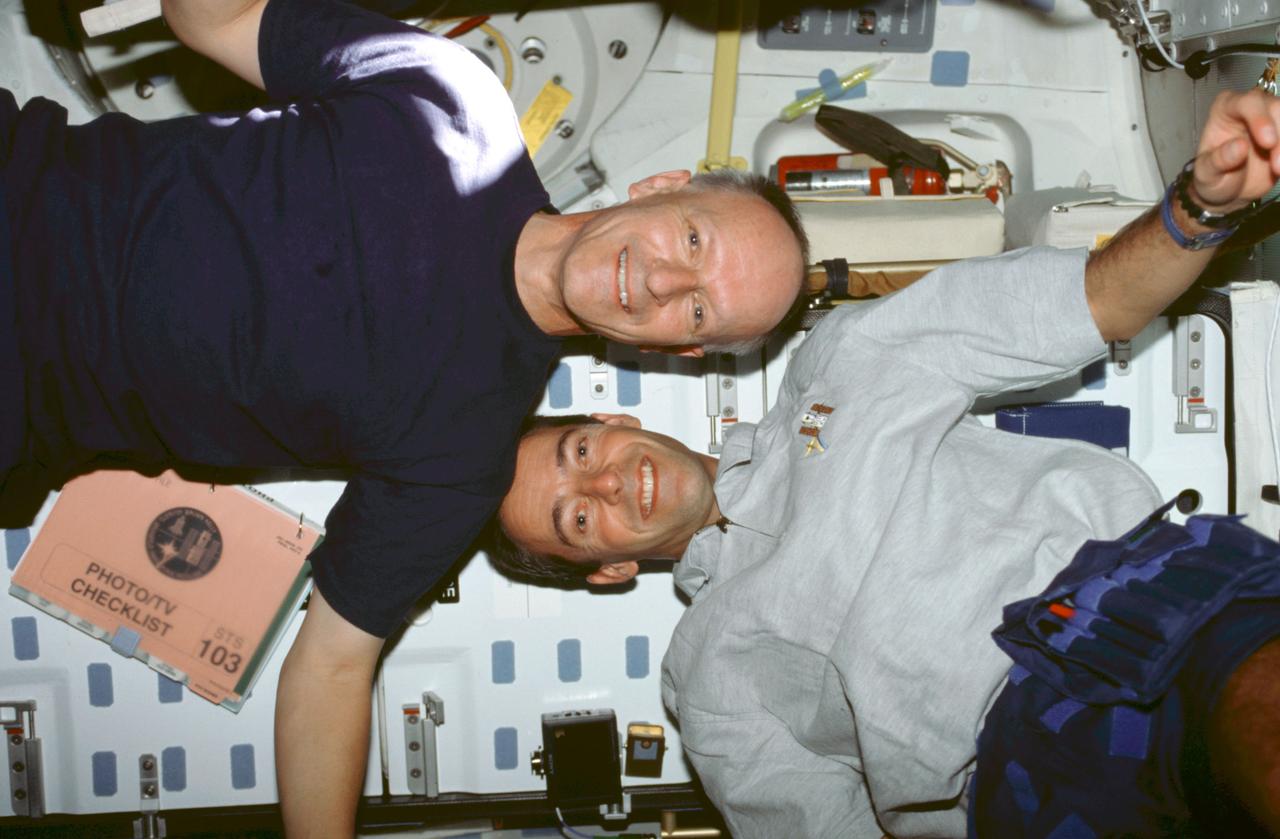
STS103-378-005 (19-27 December 1999) ---.Astronauts Claude Nicollier (left) and.Jean-Francois Clervoy, mission specialists representing the European Space Agency (ESA), move about on Discovery's mid deck in a manner they could not duplicate in Earth-bound training. A photography/television checklist floats nearby.
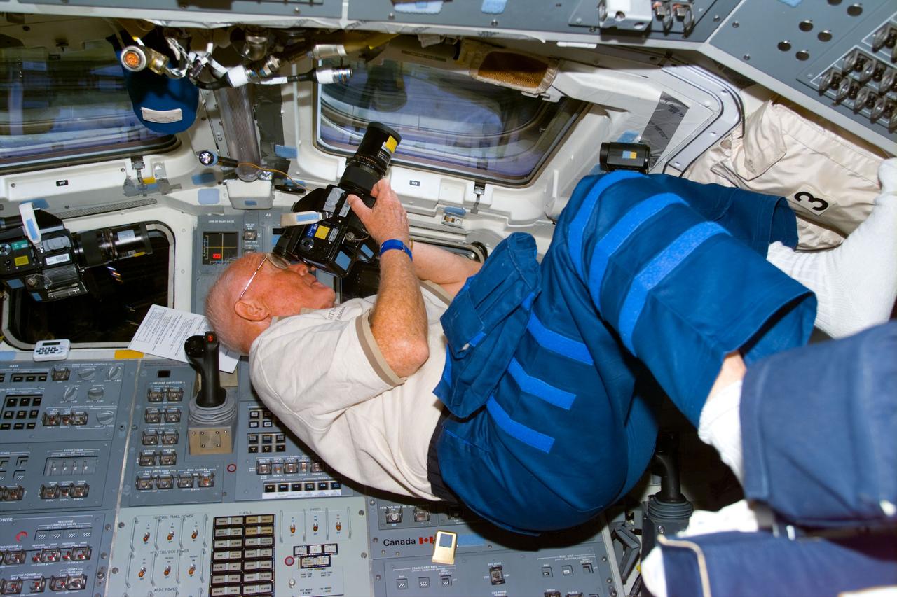
STS095-E-5190 (31 Oct. 1998) --- U.S. Sen. John H. Glenn Jr., STS-95 payload specialist, focuses in on a target of opportunity as he participates in earth observations photography. The photo was taken with an electronic still camera (ESC) at 02:21:14 GMT, Oct. 31. Photo credit: NASA
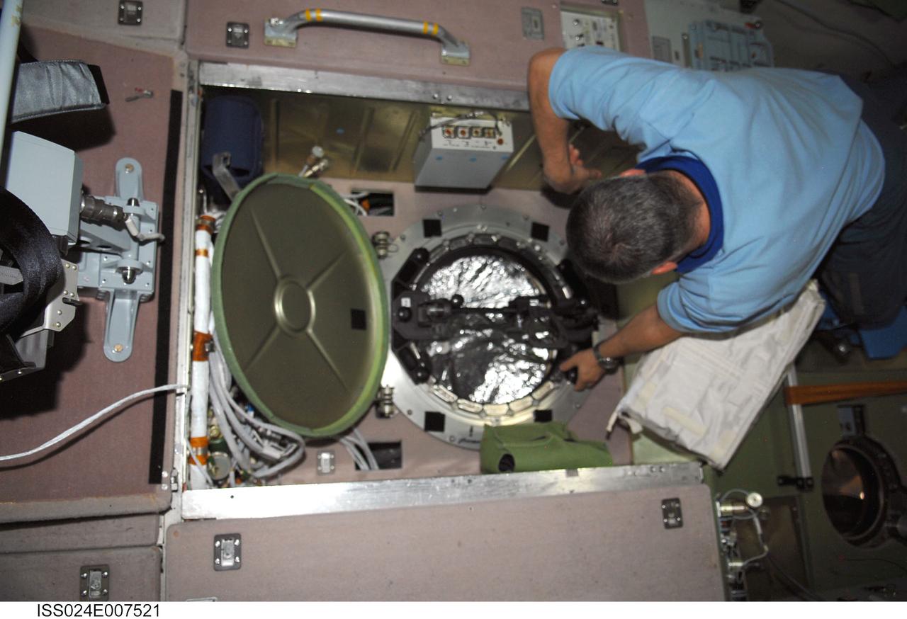
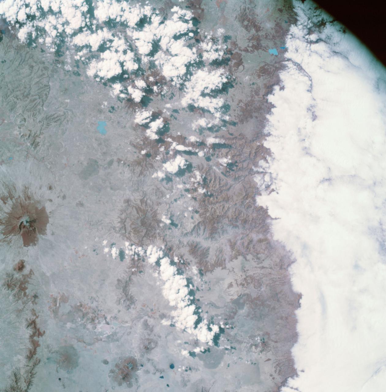
ISS024-E-007521 (8 July 2010) --- In the International Space Station’s Zvezda Service Module, Russian cosmonaut Fyodor Yurchikhin, Expedition 24 flight engineer, prepares to conduct a session for Russia's Environmental Safety Agency (EKON), making observations and taking KPT-3 aerial photography of environmental conditions on Earth.
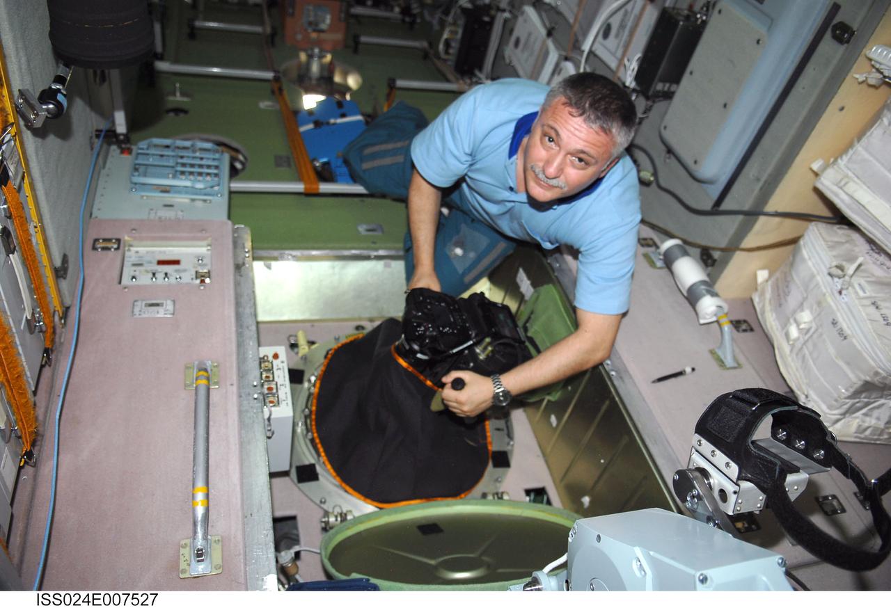
ISS024-E-007527 (8 July 2010) --- In the International Space Station’s Zvezda Service Module, Russian cosmonaut Fyodor Yurchikhin, Expedition 24 flight engineer, conducts a session for Russia's Environmental Safety Agency (EKON), making observations and taking KPT-3 aerial photography of environmental conditions on Earth.
iss070e132878 (March 31, 2024) --- Expedition 70 Flight Engineers (from left) Mike Barratt, Matthew Dominick, and Loral O'Hara participate in an Earth photography session inside the cupola, the International Space Station's "window to the world." The orbital complex was soaring 259 miles above West Virginia in the United States at the time of this photograph.
iss070e132878 (March 31, 2024) --- Expedition 70 Flight Engineers (from left) Mike Barratt, Matthew Dominick, and Loral O'Hara participate in an Earth photography session inside the cupola, the International Space Station's "window to the world." The orbital complex was soaring 259 miles above West Virginia in the United States at the time of this photograph.
AS09-26A-3768A (10 March 1969) --- Color infrared photograph of Mexico: Cerro Malinche, east end of neo-volcanic plateau, as seen from the Apollo 9 spacecraft during its 109th revolution of Earth. This picture was taken as a part of the SO65 Multispectral Terrain Photography Experiment.
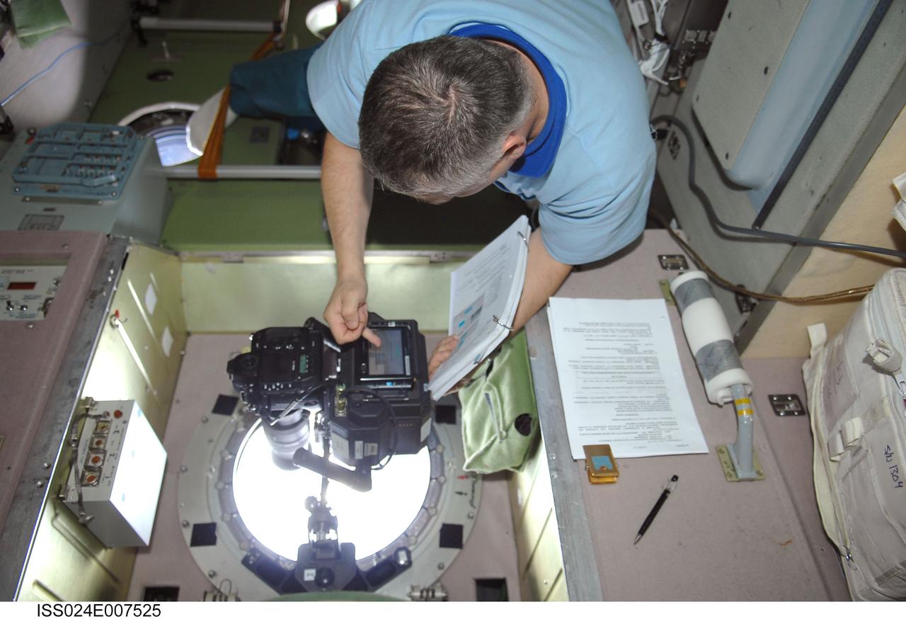
ISS024-E-007525 (8 July 2010) --- In the International Space Station’s Zvezda Service Module, Russian cosmonaut Fyodor Yurchikhin, Expedition 24 flight engineer, conducts a session for Russia's Environmental Safety Agency (EKON), making observations and taking KPT-3 aerial photography of environmental conditions on Earth.
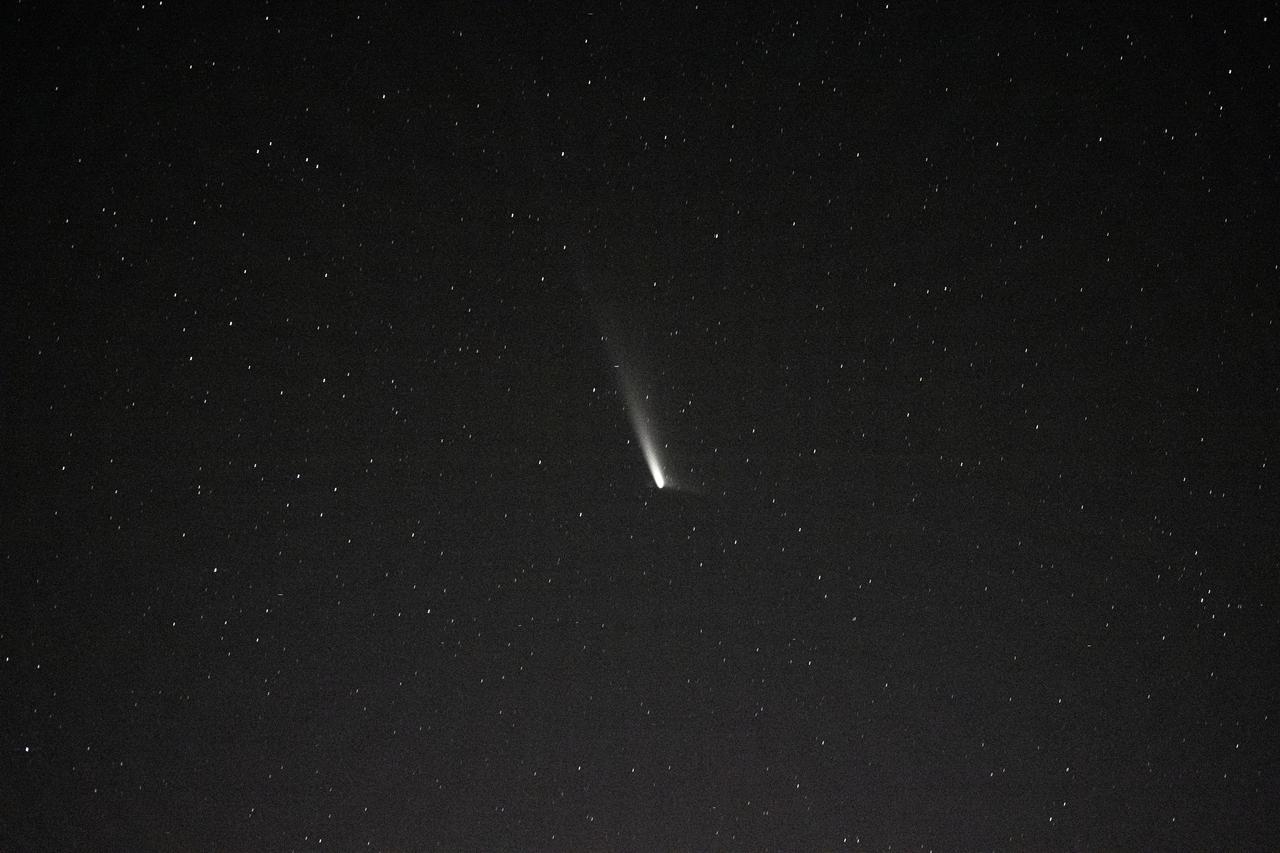
iss071e700487 (Sept. 22, 2024) --- Comet C2023-A3, or Tsuchinshan-ATLAS, was pictured about 99.4 million miles away from Earth by NASA astronaut Matthew Dominick using long-duration photography on a camera programmed for high sensitivity aboard the International Space Station
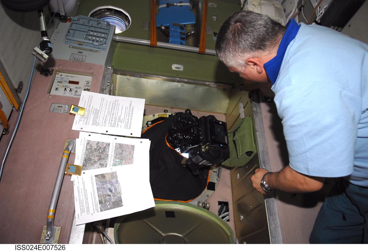
ISS024-E-007526 (8 July 2010) --- In the International Space Station’s Zvezda Service Module, Russian cosmonaut Fyodor Yurchikhin, Expedition 24 flight engineer, conducts a session for Russia's Environmental Safety Agency (EKON), making observations and taking KPT-3 aerial photography of environmental conditions on Earth.
iss071e676482 (Sept. 19, 2024) --- Comet C2023-A3, or Tsuchinshan-ATLAS, was pictured about 99.4 million miles away from Earth by NASA astronaut Matthew Dominick using long-duration photography on a camera programmed for high sensitivity aboard the International Space Station
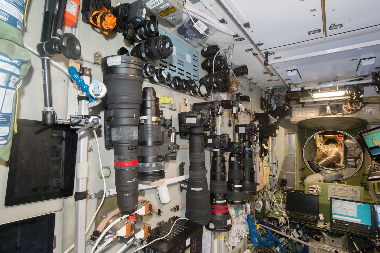
iss050e029074 (1/7/2017) --- A large selection of cameras and lenses are available to take Crew Earth Observations (CEO) photos. These cameras are in the Services Module part of the Russian Segment and near one of the windows used for Earth photography. CEO imagery provides researchers on Earth with key data to understand the planet from the perspective of the ISS. Crew members have been photographing Earth from space since the early Mercury missions beginning in 1961. The images taken from the ISS ensure this record remains unbroken.

STS029-02-002 (18 March 1989) --- Space Shuttle Discovery returns to Earth after five full days in space. Astronaut John E. Blaha mans the pilot's station. Note color in forward window shield caused by friction of entry through Earth's atmosphere. The photo was part of the first group of onboard photography from this flight released by NASA on March 19, 1989.
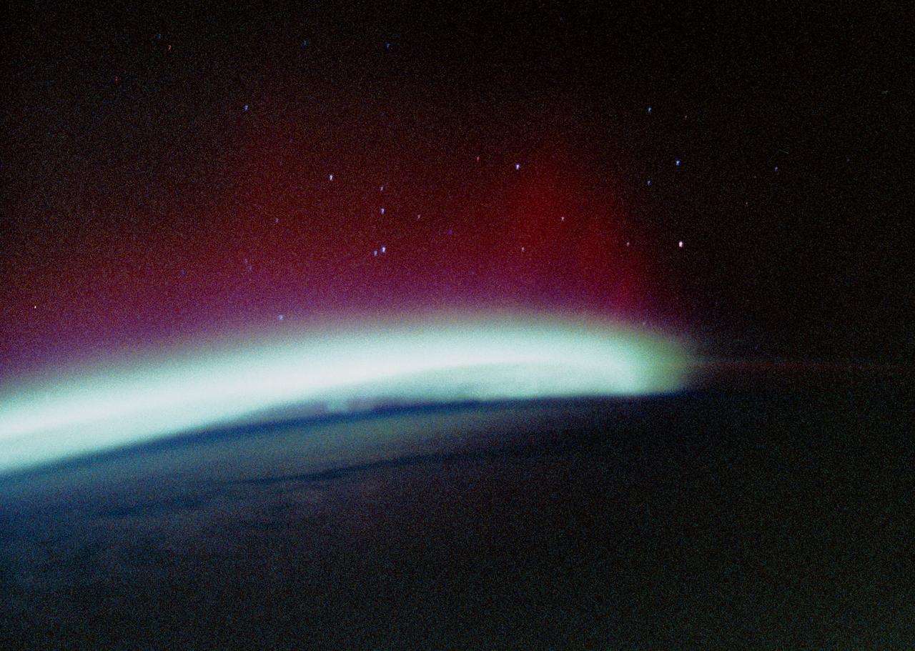
STS034-44-023 (20 Oct. 1989) --- The Southern Lights or Aurora Australis were photographed by the STS-34 crewmembers aboard the Earth-orbiting Space Shuttle Atlantis. From the Shuttle astronauts can photograph expanses of auroras, an advantage over scientists on Earth who can only get small sections at a time in a frame of photography. The space position allows for large-scale changes. This scene was one of 26 shown to the press by the five STS-34 crewmembers at their post-flight press conference.
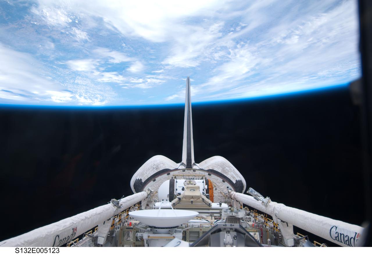
S132-E-005123 (14 May 2010) --- This photograph of space shuttle Atlantis' cargo bay and its vertical stabilizer intersecting Earth's horizon was provided on Flight Day 2 by one of the six STS-132 crew members. The photo was among the initial batch of non-engineering photography downlinked from the Earth-orbiting spacecraft on its final scheduled mission.

STS043-21-013 (2-11 August 1991) --- As on previous missions, Earth observations/photography played an important role on NASA’s STS-43 mission. That role is depicted in this scene showing astronaut James C. Adamson, mission specialist, aiming a still camera toward Earth through an overhead window on Space Shuttle Atlantis’ aft flight deck. The scene was recorded by a fellow crewmember using a 35mm camera.

STS111-321-024 (5-19 June 2002) --- This sunset over the Sahara Desert was photographed by the STS-111 crew members aboard the Space Shuttle Endeavour. When this photograph was taken, the shuttle was in a position over the Sudan near the Red Sea coast. The Gateway to Astronaut Photography of Earth (link to http://eol.jsc.nasa.gov/sseop/ ) provides searchable access to other photographs of Earth taken by astronauts.
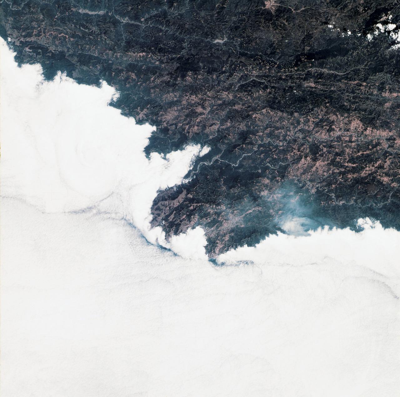
STS111-367-014 (5-19 June 2002) --- This view featuring Canadian forest fires was photographed by the STS-111 crewmembers aboard the Space Shuttle Endeavour. It represents an oblique view northward of one of the numerous fires observed and reported burning in the dry boreal forests of Saskatchewan and Manitoba during the month of June. The location of this one is roughly between Candle Lake, Saskatchewan and Lake Winnepegosis, Manitoba. The Gateway to Astronaut Photography of Earth (link to http://eol.jsc.nasa.gov/sseop/) provides searchable access to other photographs of Earth taken by astronauts.
STS111-371-003 (5-19 June 2002) --- This photo, showing Mt. St. Helens in the state of Washington, was taken by the STS-111 crewmembers aboard the Space Shuttle Endeavour. The scars from the May 18, 1980 eruption are still visible near Mt. St. Helens. Before the 1980 eruption the volcano had been dormant since 1857. The Gateway to Astronaut Photography of Earth (link to http://eol.jsc.nasa.gov/sseop/) provides searchable access to other photographs of Earth taken by astronauts.
STS111-368-036 (5-19 June 2002) --- This photo, giving detail of the Pompey Island Group in the Southern Great Barrier Reef off Australia, was taken by the STS-111 crewmembers aboard the Space Shuttle Endeavour. Ocean flow between the islands has produced unique wash features in the structures of the island banks. The Gateway to Astronaut Photography of Earth (link to http://eol.jsc.nasa.gov/sseop/) provides searchable access to other photographs of Earth taken by astronauts.

STS028-17-033 (August 1989) --- Astronaut Mark N. Brown, STS-28 mission specialist, pauses from a session of motion-picture photography conducted through one of the aft windows on the flight deck of the Earth-orbiting Space Shuttle Columbia. He is using an Arriflex camera. The horizon of the blue and white appearing Earth and its airglow are visible in the background.
STS111-362-036 (5-19 June 2002) --- This view featuring the Aurora Australis or “southern lights” was photographed by the STS-111 crew members aboard the Space Shuttle Endeavour. When this photograph was taken, the shuttle was in a position south of Australia. The Gateway to Astronaut Photography of Earth (link to http://eol.jsc.nasa.gov/sseop/) provides searchable access to other photographs of Earth taken by astronauts.

This 1970 photograph shows Skylab's Ultraviolet (UV) Airglow Horizon Photography experiment. It was an astrophysics investigation designed to photograph the twilight airflow and Earth's ozone layer simultaneously in visible and UV wavelengths. These observations provided information on oxygen, nitrogen, and ozone layers in the Earth's atmosphere, and on their variation during night and day cycles. The Marshall Space Flight Center had program management responsibility for the development of Skylab hardware and experiments.

STS060-87-087 (3-11 Feb 1994) --- Lake Baikal, in southeastern Siberia, is the largest freshwater lake in the world by volume, holding nearly 20 per cent of the world's fresh water. Lake Baikal is a biospheric reserve of high international interest to the global scientific community. It is home to some 600 endemic species, many found in no other location. This view shows the northern end of the lake, and was taken in the early morning with low sun highlighting the mountain ranges rimming the lake basin. Pristine forests surround the lake, although heavy logging is evident in other photography of the central and southern portions of the lake. Another unique aspect of Lake Baikal is the existence of the world's only known freshwater hydrothermal springs. The fault system which bounds the lake allows fluids to circulate deep into the Earth and resurface as hot springs around and in the lake. Russian and American scientists are using the Shuttle photography to examine the relationship of the lake's ice cover to areas of known hydrothermal activity. Thus Lake Baikal has been and continues to be a high-priority site for photography from space from both the Space Shuttle and the Russian Space Station MIR.
SL3-34-336 (July-September 1973) --- A vertical view of a portion of northern California near the Pacific coast as photographed from Earth orbit by one of the six lenses of the Itek-furnished S190-A Multispectral Photographic Facility Experiment in the Multiple Docking Adapter of the Skylab space station. A cloud deck covers the Pacific Ocean. Most of Cape Mendocino is clear of clouds and extends into the Pacific as the westernmost part of California. The sinuous pattern of the Bel River (in center) flows northward into the ocean and is characteristic of the rivers that drain the coastal ranges. This area is immediately southeast of Eureka. During Skylab 3 extensive forest fires occurred near Briceland and the smoke rising from the fires is clearly visible next to the cloud bank. Redwood and fir forests are sources of lumber in this region; and a variety of clear cut (timbering) patterns appear as light against the dark forest. The patterns appear to be related to the topography. Analysis of this photograph will aid Dr. P.G. Langley, Earth Satellite Corporation, in developing methods for forest inventory using space photography. Federal agencies participating with NASA on the EREP project are the Departments of Agriculture, Commerce, Interior, the Environmental Protection Agency and the Corps of Engineers. All EREP photography is available to the public through the Department of Interior?s Earth Resources Observations Systems Data Center, Sioux Falls, South Dakota, 57198. Photo credit: NASA
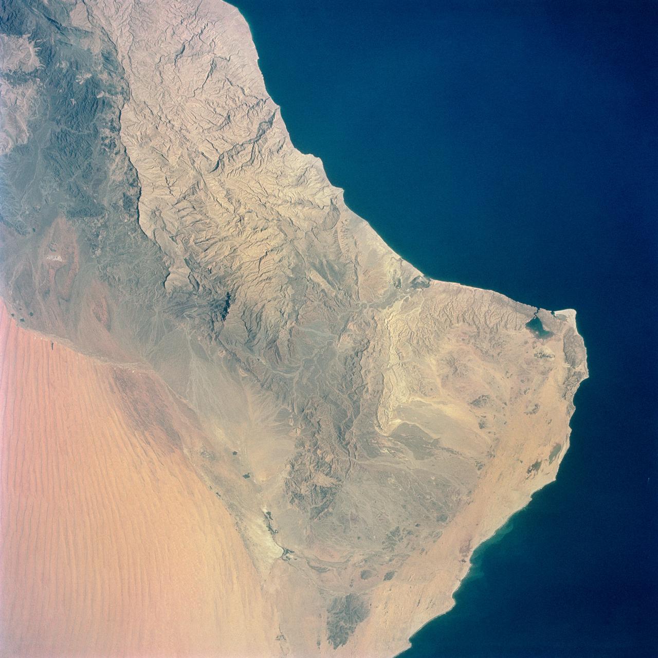
S65-34661 (3-7 June 1965) --- Among the photographs of Earth's terrain taken from the Gemini-4 spacecraft during its orbital mission was this view of the southeastern tip of the Arabian Peninsula with the Gulf of Oman at upper right. Seif dunes (sand) at lower left. This picture was taken with a modified 70mm Hasselblad camera, using Eastman color film, ASA 64 at a setting of 250th of a second at f/11. Dr. Paul Lowman Jr., NASA geologist, was in charge of the Synoptic Terrain Photography.

ISS043E091837 (04/07/2015) --- NASA astronaut Terry Virts, Commander of Expedition 43 aboard the International Space Station, dons eye protection from the sun while working in Cupola, the station’s 360 degree viewing platform. The Cupola contains the primary control station for the station’s robotic arm, Canadarm2, which the crew use to capture visiting spacecraft like SpaceX’s Dragon and Orbital ATK’s Cygnus. The specialized windows also provide one of the best vantage points on station for Earth study and photography.
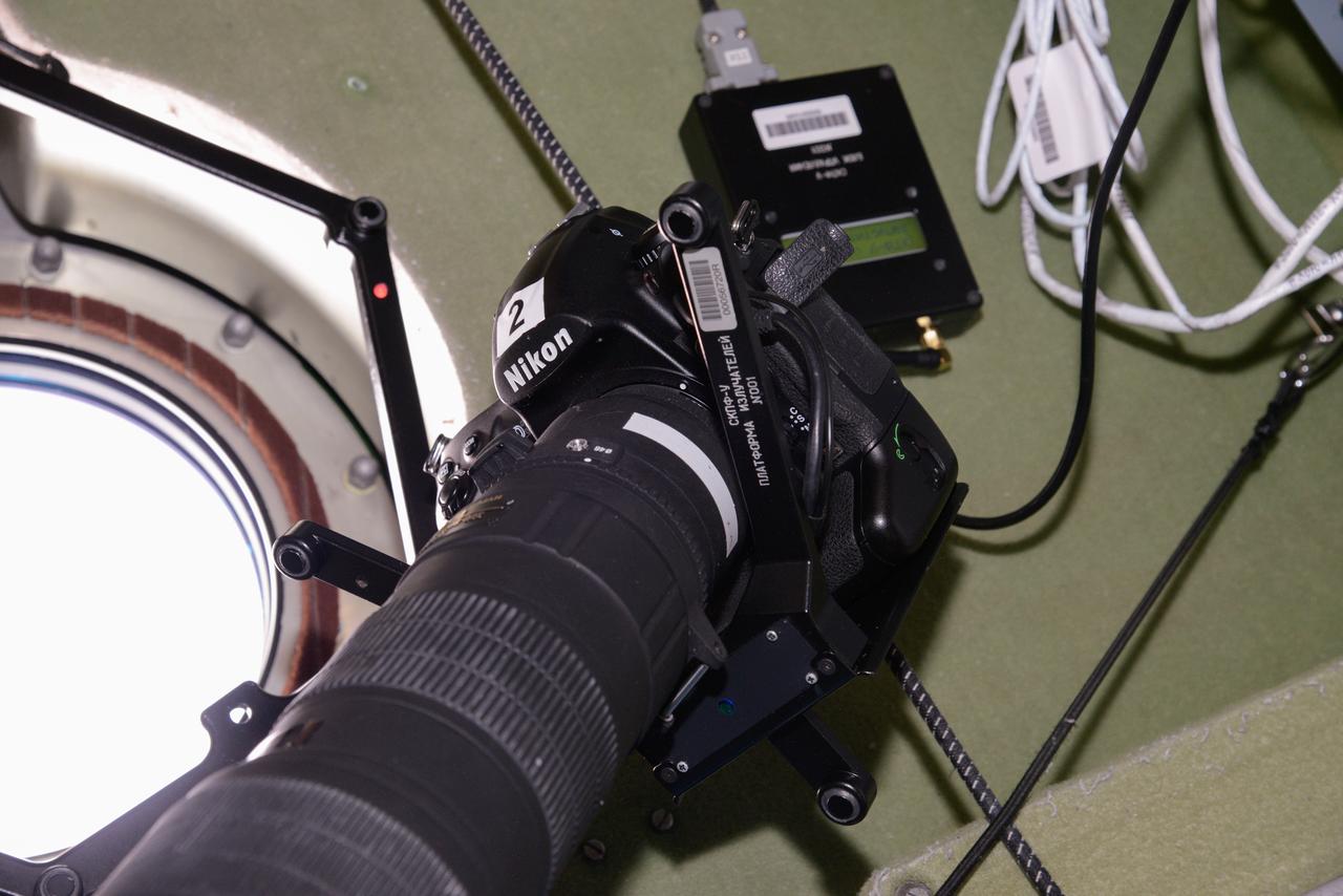
iss048e014045 (6/27/2016) --- Photo documentation of a still camera and Photo Image Coordinate Reference System (СКПФ-У) hardware in use during a Vizir experiment session in the Zvezda Service Module (SM). The Experimental Testing of a System of Photo Imagery Coordinate Referencing Using Ultrasound Sensors (Vizir) tests the technology of automated coordinate referencing of images of the Earth’s surface, and space, taken by crewmembers using “free-floating” photography equipment in weightlessness.

STS-65 Earth observation taken aboard Columbia, Orbiter Vehicle (OV) 102, shows Hurricane Emilia in the Eastern Pacific Ocean. Hurricane Emilia's wind speeds exceeded 150 knots. This high oblique view of the storm shows numerous spiral bands of thunderstorms, overshooting thunderstorm tops at the tropopause, and a well developed eye at the center of the picture. Shuttle photography provides high resolution details of these powerful and destructive systems that are not fully possible from lower-resolution, unmanned satellites.
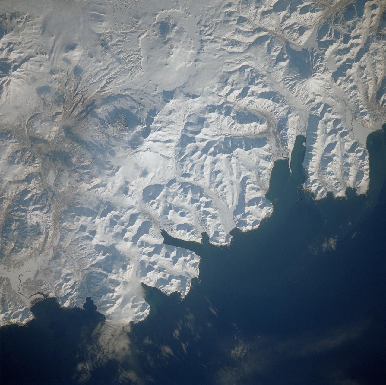
STS039-81-00OU (28 April-6 May 1991) --- Flying at an inclination of 57 degrees to Earth's Equator, the Space Shuttle Discovery was able to record photography of a number of seldom observed areas on the planet, such as the USSR. This view was taken in the far north Pacific Ocean and shows part of the Kamchatka Peninsula. One of Discovery's seven crewmembers aimed a 70mm handheld camera through aft flight deck overhead windows to record the image.

STS102-342-024 (8-21 March 2001)--- The largest percentage of astronaut out-the-window photography is scientific in nature. However, occasionally scenes such as this one showing the moon over Earth's airglow are irresistable for crew members with cameras. The 35mm scene was recorded by one of the STS-102 astronauts from the aft flight deck of the Space Shuttle Discovery.

STS030-08-015 (4-8 May 1989) --- Astronaut Mark C. Lee, STS-30 mission specialist, pauses from a of Earth photography on Atlantis' aft flight deck. He holds a 70mm camera. The scene was recorded with a 35mm camera. The photo was in a group released by NASA following the completion of a four-day mission in space.
ss042e127115 (1/15/2015) --- Photo documentation of a ИКМ beacon attached to a corner of the galley table in the Zvezda Service Module (SM). Image was taken during Vizir experiment operations (OPS). Experimental Testing of a System of Photo Imagery Coordinate Referencing Using Ultrasound Sensors (Vizir) tests the technology of automated coordinate referencing of images of the Earth’s surface, and space, taken by crewmembers using “free-floating” photography equipment in weightlessness.
STS050-06-011 (25 June-9 July 1992) --- Astronaut Carl J. Meade (left), mission specialist, and Eugene H. Trinh, payload specialist, share a view through one of the Space Shuttle Columbia's aft flight deck windows during a break in photography of Earth. The two were among seven crew members who shared 14 record-setting days aboard the Space Shuttle supporting the United States Microgravity Laboratory (USML-1) mission.
AS09-26A-3741A (9 March 1969) --- Color infrared photograph of the Mississippi River between Vicksburg and Greenville as photographed from the Apollo 9 spacecraft during its 92nd revolution of Earth. This picture was a part of the SO65 Multispectral Terrain Photography Experiment. The City of Vicksburg is located in the southeast corner of the picture. Note Interstate 20 under construction running east and west. Greenville is just out of picture at top center. All east of river is Mississippi; Louisiana is at lower left; and Arkansas is at upper left.
STS005-14-514 (11-16 Nov. 1982) --- This 35mm frame, taken against sunglint, shows clouds over the Pacific Ocean. A Nikon F-3 35mm modified camera and Type 5017, medium speed Ektachrome film were used to record the frame. Approximately 20 frames of 35mm and several dozen frames of 70mm photography of Earth were exposed on the week-long mission aboard the space shuttle Columbia (STS-5). Photo credit: NASA
AS09-26A-3727A (8 March 1969) --- Color infrared photograph of the Texas Gulf Coast, Galveston Bay to Matagorda Bay, as seen from the Apollo 9 spacecraft during it 78th revolution of Earth. Houston is located at right center edge of photograph. Also visible are Galveston, Texas City, Manned Spacecraft Center, and Freeport. The mouth of the Colorado River is located near left center edge of picture. This picture was taken as a part of the SO65 Multispectral Terrain Photography Experiment.

ISS043E294202 (06/10/2015) --- NASA astronaut Scott Kelly is photographed in the Japanese Experiment Module (JEM) holding a sign with the hashtag #whyspacematters. NASA and the United Nations Office for Outer Space Affairs (UNOOSA) have launched a global photography competition to highlight how the vantage point of space helps us better understand our home planet, improve lives, and safeguard our future by aiding sustainable development on Earth.
STS029-04-032 (13-18 March 1989) --- This scene was a common one during the five-day flight of STS-29. Astronaut John E. Blaha, STS-29 pilot, aims the IMAX camera at Earth through one of Discovery's overhead windows. The scene was recorded with a 35mm camera. The photo was part of the first group of onboard photography from this flight released by NASA on Mar. 19, 1989.
STS039-81-00OW (28 April-6 May 1991) --- This scene shows a small area of the north Pacific coast of the USSR's Kamchatka peninsula. Flying at an inclination of 57 degrees to Earth's Equator, the Space Shuttle Discovery was able to record photography of a number of seldom observed areas on the planet, such as the USSR. One of Discovery's seven crewmembers aimed a 70mm handheld camera through aft flight deck overhead windows to record the image.

ISS028-E-017197 (16 July 2011) --- One of the members of the joint crews for STS-135 and International Space Station Expedition 28 exposed this image of Atlantis and its Orbital Boom Sensor System robot arm extension backdropped against Earth's horizon and a greenish phenomenon associated with Aurora Australis. One of the station's solar array panels appears at upper left. Because of exposure time needed for this type photography, some of the stars in the background are blurred.
jsc2025e086642 --- NASA astronaut and Artemis II commander, Reid Wiseman (foreground), and CSA (Canadian Space Agency) astronaut and Artemis II mission specialist, practice lunar photography at NASA's Johnson Space Center in Houston. The Artemis II crew will be the first people in more than 50 years to set eyes on the far side of the Moon, depending on illumination conditions. They will document their observations through photographs, audio recordings, and more to inform our understanding of the Moon, and share their experience of being far from Earth. Credit: Kelsey Young

iss053e137952 (10/30/2017) --- Photo documentation of VIZIR experiment set up and start using СКПИ payload. The Experimental Testing of a System of Photo Imagery Coordinate Referencing Using Ultrasound Sensors (Vizir) tests the technology of automated coordinate referencing of images of the Earth’s surface, and space, taken by crewmembers using “free-floating” photography equipment in weightlessness.
iss048e014043 (6/27/2016) --- Photo documentation of Photo Image Coordinate Reference System (СКПФ-У) hardware in use during a Vizir experiment session in the Zvezda Service Module (SM). The Experimental Testing of a System of Photo Imagery Coordinate Referencing Using Ultrasound Sensors (Vizir) tests the technology of automated coordinate referencing of images of the Earth’s surface, and space, taken by crewmembers using “free-floating” photography equipment in weightlessness.
AS09-26A-3798A (12 March 1969) --- Color infrared photograph of the San Diego County and San Diego area of southern California as photographed from the Apollo 9 spacecraft during its 136th revolution of Earth. This picture was taken as a part of the SO65 Multispectral Terrain Photography Experiment. Tijuana and a portion of Baja California, Mexico, are also visible in picture.
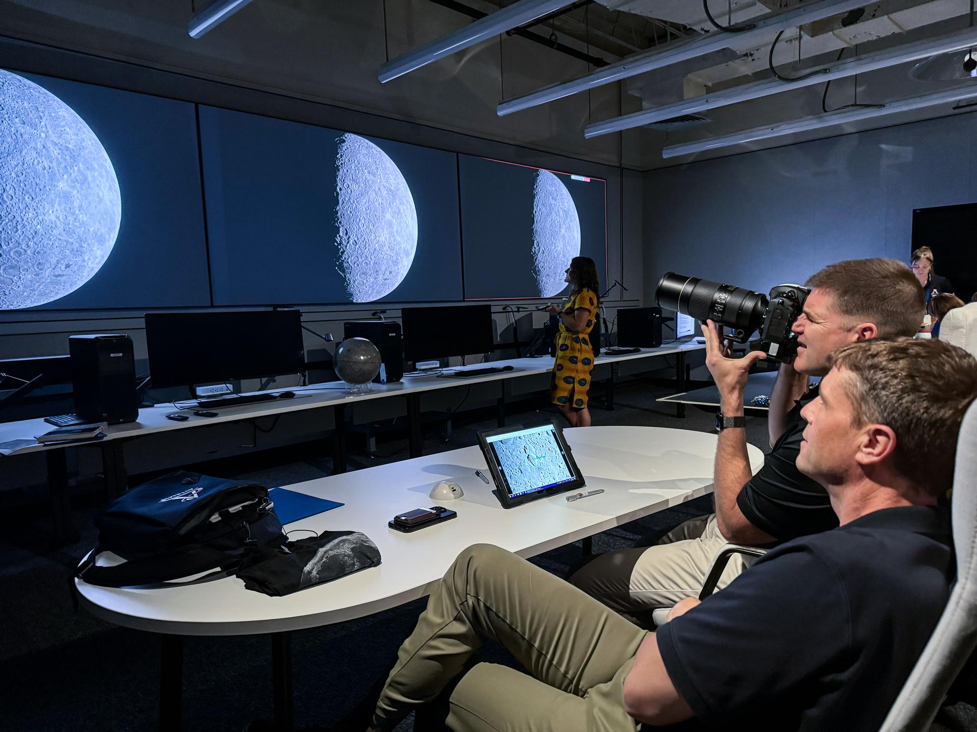
jsc2025e087135 --- NASA astronaut and Artemis II commander, Reid Wiseman (foreground), and CSA (Canadian Space Agency) astronaut and Artemis II mission specialist, practice lunar photography at NASA's Johnson Space Center in Houston. The Artemis II crew will be the first people in more than 50 years to set eyes on the far side of the Moon, depending on illumination conditions. They will document their observations through photographs, audio recordings, and more to inform our understanding of the Moon, and share their experience of being far from Earth. Credit: Kelsey Young

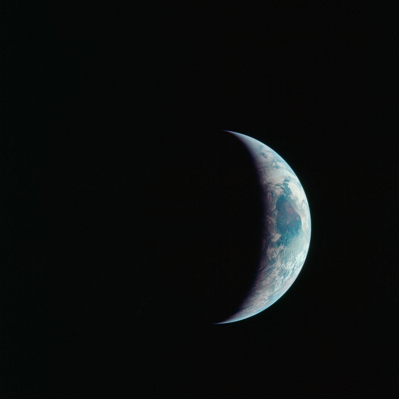
AS16-118-18885 (16 April 1972) --- A good view of Earth photographed about one and one-half hours after trans-lunar injection on April 16, 1972. Although there is much cloud cover, the United States in large part, most of Mexico and some parts of Central America are clearly visible. Note Lake Michigan and Lake Superior and the Bahama Banks (see different shade of blue below Florida). Just beginning man's fifth lunar landing mission were astronauts John W. Young, commander; Thomas K. Mattingly, II, command module pilot and Charles M. Duke Jr., lunar module pilot. While astronauts Young and Duke descended in the Lunar Module (LM) "Orion" to explore the Descartes highlands region of the moon, astronaut Mattingly remained with the Command and Service Modules (CSM) "Casper" in lunar orbit.

AS16-118-18880 (16 April 1972) --- A good view of Earth photographed about one hour after trans-lunar injection on April 16, 1972. Although there is much cloud cover, the United States in large part, most of Mexico and some of Central America are clearly visible. Note the Great Lakes (Michigan and Superior) and the Bahama Banks (note different shade of blue below Florida). While astronauts John W. Young, commander, and Charles M. Duke Jr., lunar module pilot, descended in the Lunar Module (LM) "Orion" to explore the Descartes highlands region of the moon, astronaut Thomas K. (Ken) Mattingly II, command module pilot, remained with the Command and Service Modules (CSM) "Casper" in lunar orbit.

AS17-148-22727 (7 Dec. 1972) --- This view of Earth was seen by the Apollo 17 crew as they traveled toward the moon on their NASA lunar landing mission. This outstanding trans-lunar coast photograph extends from the Mediterranean Sea area to the Antarctica south polar ice cap. This is the first time the Apollo trajectory made it possible to photograph the south polar ice cap. Note the heavy cloud cover in the Southern Hemisphere. Almost the entire coastline of Africa is clearly visible. The Arabian Peninsula can be seen at the northeastern edge of Africa. The large island off the coast of Africa is the Malagasy Republic. The Asian mainland is on the horizon toward the northeast. The Apollo 17 crew consisted of astronauts Eugene A. Cernan, mission commander; Ronald E. Evans, command module pilot; and Harrison H. Schmitt, lunar module pilot. While astronauts Cernan and Schmitt descended in the Lunar Module (LM) to explore the moon, astronaut Evans remained with the Command and Service Modules (CSM) in lunar orbit.
S62-01287 (21 July 1961) --- Earth observation take during the Mercury-Redstone 4 (MR-4) spaceflight. Photo credit: NASA
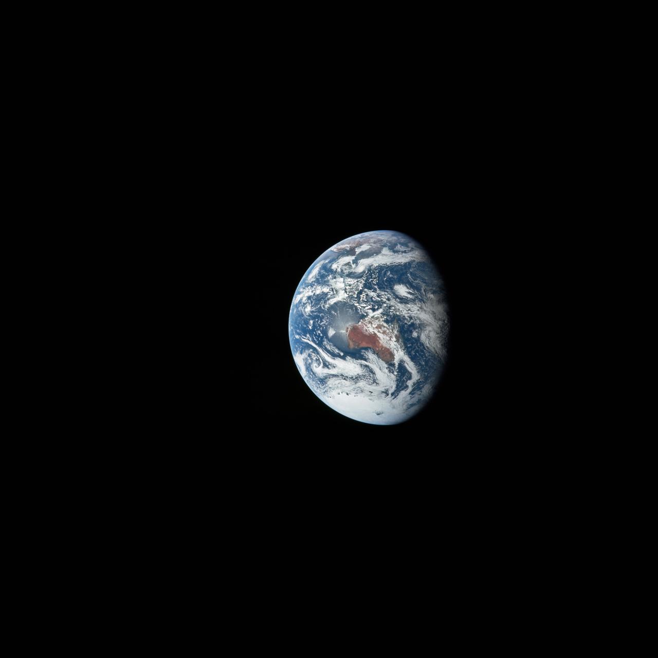
AS12-50-7362 (14 Nov. 1969) --- A view of one-third of Earth, with Australia on the horizon, as photographed by the three-man crew of Apollo 12. The Command and Service Modules, mated to the Lunar Module (yet to be removed and transpositioned for landing) were en route to the moon for man's second mission there. Onboard the spacecraft were astronauts Charles Conrad Jr., Richard F. Gordon Jr. and Alan L. Bean. Photo credit: NASA
AS17-148-22742 (7-19 Dec. 1972) --- Most of Australia (center) and part of Antarctica are visible in this photo of a three-quarters Earth, recorded with a 70mm handheld Hasselblad camera using a 250mm lens. The three astronauts aboard the Command and Service Modules (CSM) were in the trans-lunar coast phase of the journey when one of them snapped this shot. While astronauts Eugene A. Cernan commander, and Harrison H. Schmitt, lunar module pilot, descended in the Lunar Module (LM) "Challenger" to explore the Taurus-Littrow region of the moon, astronaut Ronald E. Evans, command module pilot, remained with the CSM "America" in lunar orbit.

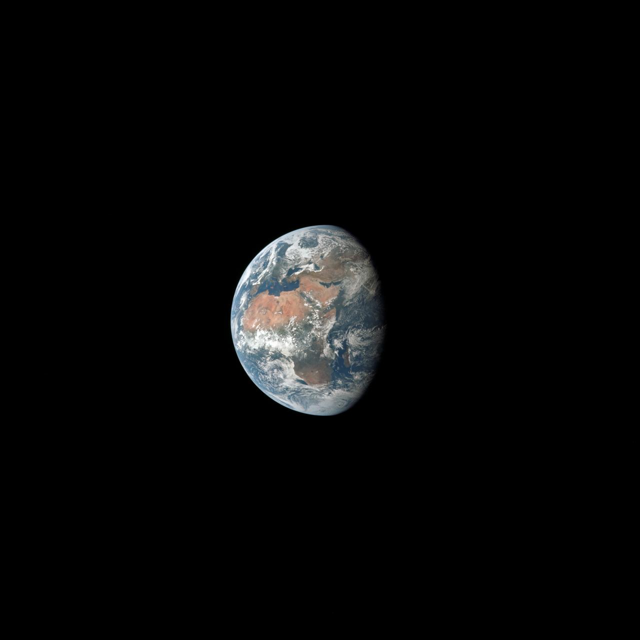
AS10-34-5026 (18-26 May 1969) --- An Apollo 10 photograph of Earth taken from 100,000 miles away. Visible are many areas of Europe and Africa. Among the features and countries identifiable are Portugal, Spain, Italy, the Mediterranean Sea, Greece, Turkey, Bulgaria, the Black Sea, Libya, Egypt, Saudi Arabia, the Sinai Peninsula, the Nile Delta, Lake Chad, and South Africa. The crew members for Apollo 10 are astronauts Thomas P. Stafford, commander; John W. Young, command module pilot; and Eugene E. Cernan, lunar module pilot. Astronaut Young remained in lunar orbit, in the Command and Service Modules (CSM) "Charlie Brown", while astronauts Stafford and Cernan descended to within nine miles of the lunar surface, in the Lunar Module (LM) "Snoopy".

AS11-36-5337 (16 July 1969) --- This view of Earth showing clouds over its surface was photographed from the Apollo 11 spacecraft during its translunar journey toward the moon. The spacecraft was already about 10,000 nautical miles from Earth when this picture was taken. Portions of the land mass of North America and Central America can be seen. Aboard Apollo 11 were astronauts Neil A. Armstrong, Michael Collins and Edwin E. Aldrin Jr.

AS13-60-8588 (17 April 1970) --- This photograph of Earth was taken from the National Aeronautics and Space Administration's (NASA) Apollo 13 spacecraft during its trans-Earth journey home. The most visible land mass includes southwestern United States and northwestern Mexico. The peninsula of Baja California is clearly seen. Most of the land area is under heavy cloud cover. The Apollo 13 crew consisted of astronauts James A. Lovell Jr., commander; John L. Swigert Jr., command module pilot; and Fred W. Haise Jr., lunar module pilot.

AS10-34-5013 (18 May 1969) --- A view of Earth from 36,000 nautical miles away as photographed from the Apollo 10 spacecraft during its trans-lunar journey toward the moon. While the Yucatan Peninsula is obscured by clouds, nearly all of Mexico north of the Isthmus of Tehuantepec can be clearly delineated. The Gulf of California and Baja California and the San Joaquin Valley can be easily identified. Also, the delta of the Rio Grande River and the Texas coast are visible. Note the color differences (greens - east, browns - west) along the 100 degrees meridian. The crew members on Apollo 10 are astronauts Thomas P. Stafford, commander; John W. Young, command module pilot; and Eugene E. Cernan, lunar module pilot. Astronaut Young remained in lunar orbit, in the Command and Service Modules (CSM) "Charlie Brown", while astronauts Stafford and Cernan descended to within nine miles of the lunar surface, in the Lunar Module (LM) "Snoopy".
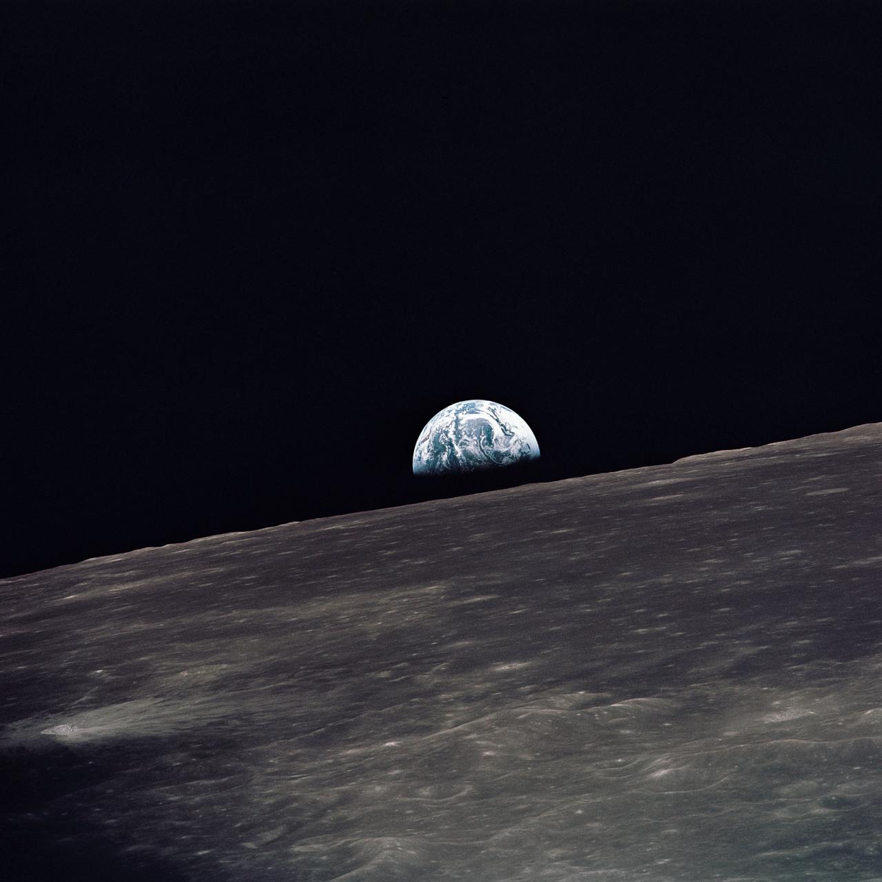
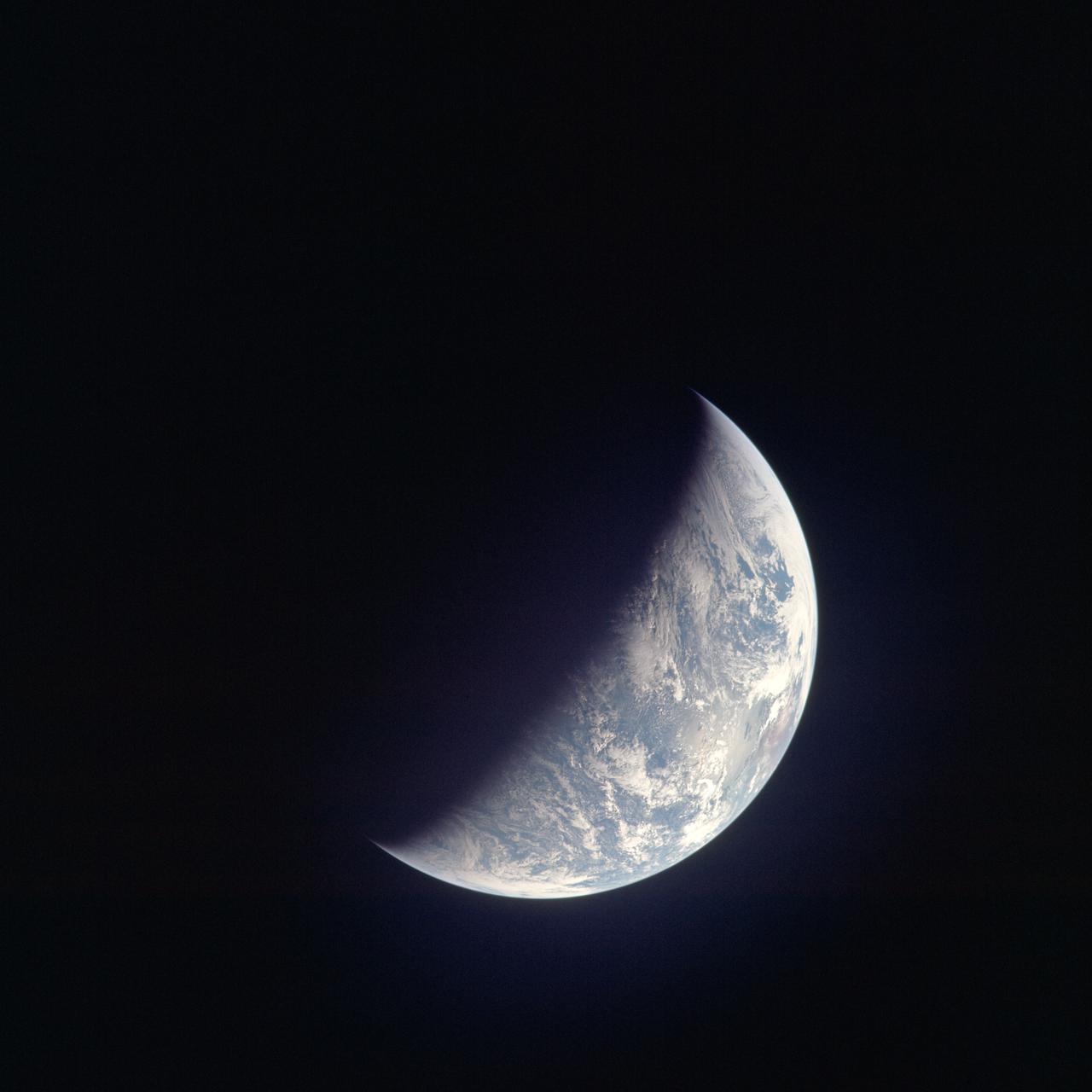
AS10-27-3890 (18-26 May 1969) --- A view of Earth rising above the lunar horizon photographed from the Apollo 10 Lunar Module, looking west in the direction of travel. The Lunar Module at the time the picture was taken was located above the lunar farside highlands at approximately 105 degrees east longitude.

AS11-36-5299 (16 July 1969) --- This view of Earth showing clouds over water was photographed from the Apollo 11 spacecraft following translunar injection. While astronauts Neil A. Armstrong, commander, and Edwin E. Aldrin Jr., lunar module pilot, descended in the Lunar Module (LM) "Eagle" to explore the Sea of Tranquility region of the moon, astronaut Michael Collins, command module pilot, remained with the Command and Service Modules (CSM) "Columbia" in lunar orbit.
AS11-36-5355 (17 July 1969) --- Most of Africa and portions of Europe and Asia can be seen in this spectacular photograph taken from the Apollo 11 spacecraft during its trans-lunar coast toward the moon. Apollo 11, with astronauts Neil A. Armstrong, commander; Michael Collins, command module pilot; and Edwin E. Aldrin Jr., lunar module pilot, onboard was already 98,000 nautical miles from Earth when this picture was made. While astronauts Armstrong and Aldrin descended in the Lunar Module (LM) "Eagle" to explore the Sea of Tranquility region of the moon, astronaut Collins remained with the Command and Service Modules (CSM) "Columbia" in lunar orbit.

AS08-16-2596 (21-27 Dec. 1968) --- View of Earth as photographed by the Apollo 8 astronauts during their lunar orbit mission. North is about five percent to the right of vertical. The sunset terminator crosses North and South America. Clouds cover most of the United States. Only the desert southwest and Florida are clear.
AS11-44-6689 (16-24 July 1969) --- One-third of the Earth's sphere illuminated, Earth's terminator, sunglint, a portion of east Africa, as photographed from the Apollo 11 spacecraft during its first lunar landing mission. While astronauts Neil A. Armstrong, commander, and Edwin E. Aldrin Jr., lunar module pilot, descended in the Lunar Module (LM) "Eagle" to explore the Sea of Tranquility region of the moon, astronaut Michael Collins, command module pilot, remained with the Command and Service Modules (CSM) "Columbia" in lunar orbit.
AS16-118-18873 (16 April 1972) --- A good view of Earth photographed shortly after trans-lunar injection of April 16, 1972. Although there is much cloud cover (over Canada and the oceans), the United States in large part, most of Mexico and some parts of Central America are clearly visible. Note Lake Michigan and Lake Superior, also note the Bahama Banks at upper right part of the sphere. A large part of the Rocky Mountain Range is also visible. Just beginning man's fifth lunar landing mission were astronauts John W. Young, commander; Thomas K. Mattingly II, command module pilot; and Charles M. Duke Jr., lunar module pilot. While astronauts Young and Duke descended in the Lunar Module (LM) to explore the moon, astronaut Mattingly remained with the Command and Service Modules (CSM) in lunar orbit.

AS15-91-12343 (26 July 1971) --- This view of Earth was photographed by the Apollo 15 crewmen as they sped toward the fourth lunar landing. The spacecraft was between 25,000 and 30,000 nautical miles from Earth when this photo was made. The United States (note Florida), Central America and part of Canada can be seen at the left side of the picture, with South America at lower center. Spain and the northwest part of Africa can be seen at right. The Bahamas Banks, unique geological feature, can be seen (different shade of blue) east of Florida. Also note large North Atlantic storm front moving over Greenland in upper center.

AS10-34-5010 (18 May 1969) --- This photograph of Earth was taken from the Apollo 10 spacecraft shortly after trans-lunar insertion. The counter-clockwise arrangement of the cloud formations indicates a northern hemisphere view, although insufficient amounts of land are visible for exact location.
AS11-43-6412 (July 1969) --- This is a northeasterly, low-oblique view of an unmanned crater and highland area on the lunar farside, as photographed from Apollo 11. The center of the picture is located at the 167 degrees east longitude and 6 degrees north latitude. This area of the moon lies just east of International Astronomical Union crater No. 220.
AS11-43-6439 (July 1969) --- An Apollo 11 oblique view of the lunar farside. The linear group of small craters is located within the large International Astronomical Union crater No. IX, and is centered at 139.5 degrees east longitude and 7 degrees north latitude. The absence of shadows is due to the high sun angle. The crater chain is approximately 34 statute miles in length, and the large crater adjacent to the crater is 10.5 statute miles in diameter.
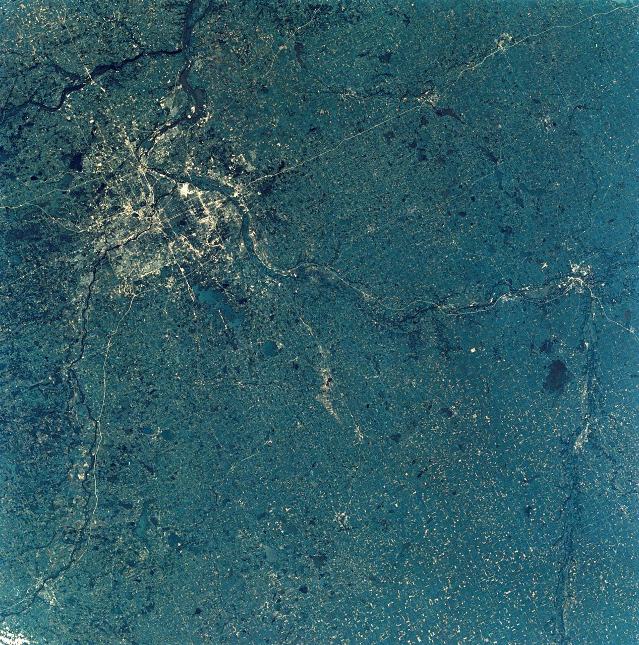
SL3-28-009 (July-September 1973) --- A near vertical view of the Minneapolis-St. Paul, Minnesota area, as photographed from Earth orbit by one of the six lenses of the Itek-furnished S190-A Multispectral Photographic Facility Experiment in the Multiple Docking Adapter of the Skylab space station. A 150mm lens, with SO-356 high definition Ektachrome film, was used to take this picture. The Mississippi River flows southeasterly through this large metropolitan area. Minneapolis is on the west bank of the Mississippi. The Minnesota River makes a large bend at the southern edge of the picture then flows northeasterly to empty into the Mississippi at Minneapolis-St. Paul. The St. Croix River, which serves as a portion of the boundary between Minnesota and Wisconsin, flows into the Mississippi downstream from the twin cities. A long, nearly straight, stretch of Interstate 35 leads southward from Minneapolis-St. Paul. Interstate 94 parallels the Mississippi toward the northwest. The highway and road network in the area is clearly visible. Note the numerous small lakes in the photograph. This view includes the smaller cities of Hastings, Faribault, Owatonna, Mankato, St. Peter, New Ulm and St. Cloud. The S190-A experiment is part of the Skylab Earth Resources Experiments Package. Photo credit: NASA
AS11-42-6285 (July 1969) --- An Apollo 11 view of a bright rayed crater on the lunar farside. The crater is unnamed. The center of this photograph is located at 100 degrees southeast longitude and 4 degrees 30 minutes north latitude. This area is just east of Smyth's Sea.
AS11-42-6248 (July 1969) --- An Apollo 11 oblique view of the lunar farside in the area of International Astronomical Union crater No. 312, which is about 30 statute miles in diameter. The center of the photograph is located at 164 degrees west longitude and 8 degrees south latitude. The sharp shadows indicate that the picture was taken at a low sun angle.
AS11-42-6237 (20 July 1969) --- An Apollo 11 oblique view of the large crater Theophilus located at the northwest edge of the Sea of Nectar on the lunar nearside. Theophilus is about 60 statute miles in diameter. The smooth area is Mare Nectaris. The smaller crater Madler, about 14 statute miles in diameter, is located to the east of Theophilus. Visible in the background are the large crater Fracastorius and the smaller crater Beaumont. The coordinates of the center of this photograph are 29 degrees east longitude and 11 degrees south latitude.
AS11-43-6422 (July 1969) --- An Apollo 11 oblique view of the lunar farside. These two odd-shaped craters are located midway between International Astronomical Union craters 218 and 220, and are centered at 155 degrees east longitude and 3 degrees north latitude. The craters total approximately 13.5 statute miles in length and 7.5 statute miles in width at their widest point.
AS11-44-6609 (16-24 July 1969) --- An oblique of the Crater Daedalus on the lunar farside as seen from the Apollo 11 spacecraft in lunar orbit. The view looks southwest. Daedalus (formerly referred to as I.A.U. Crater No. 308) is located at 179 degrees east longitude and 5.5 degrees south latitude. Daedalus has a diameter of about 50 statute miles. This is a typical scene showing the rugged terrain on the farside of the moon. While astronauts Neil A. Armstrong, commander, and Edwin E. Aldrin Jr., lunar module pilot, descended in the Lunar Module (LM) "Eagle" to explore the Sea of Tranquility region of the moon, astronaut Michael Collins, command module pilot, remained with the Command and Service Modules (CSM) "Columbia" in lunar orbit.
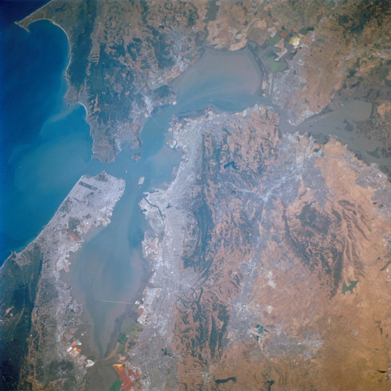
STS111-712-028 (5-19 June 2002) --- This photo featuring the San Francisco Bay area in California was photographed by one of the STS-111 crewmembers aboard the Space Shuttle Endeavour. The gray urban footprint of San Francisco, Oakland, San Jose, and the surrounding suburbs contrasts strongly with the brown and green vegetation in the hillsides. At the top and bottom of the picture the green, red and yellow pools are impoundments and salt evaporation ponds. The Gateway to Astronaut Photography of Earth (link to http://eol.jsc.nasa.gov/sseop/) provides searchable access to other photographs of Earth taken by astronauts.