
NASA Dryden life support technician Jim Sokolik assists pressure-suited pilot Dee Porter into the cockpit of NASA's ER-2 Earth resources aircraft.

The large air intakes for its powerful engine are obvious as NASA's high-flying ER-2 #806 Earth resources aircraft taxies out for another science mission.
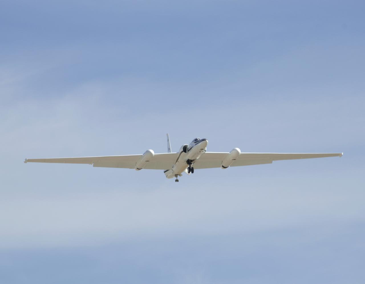
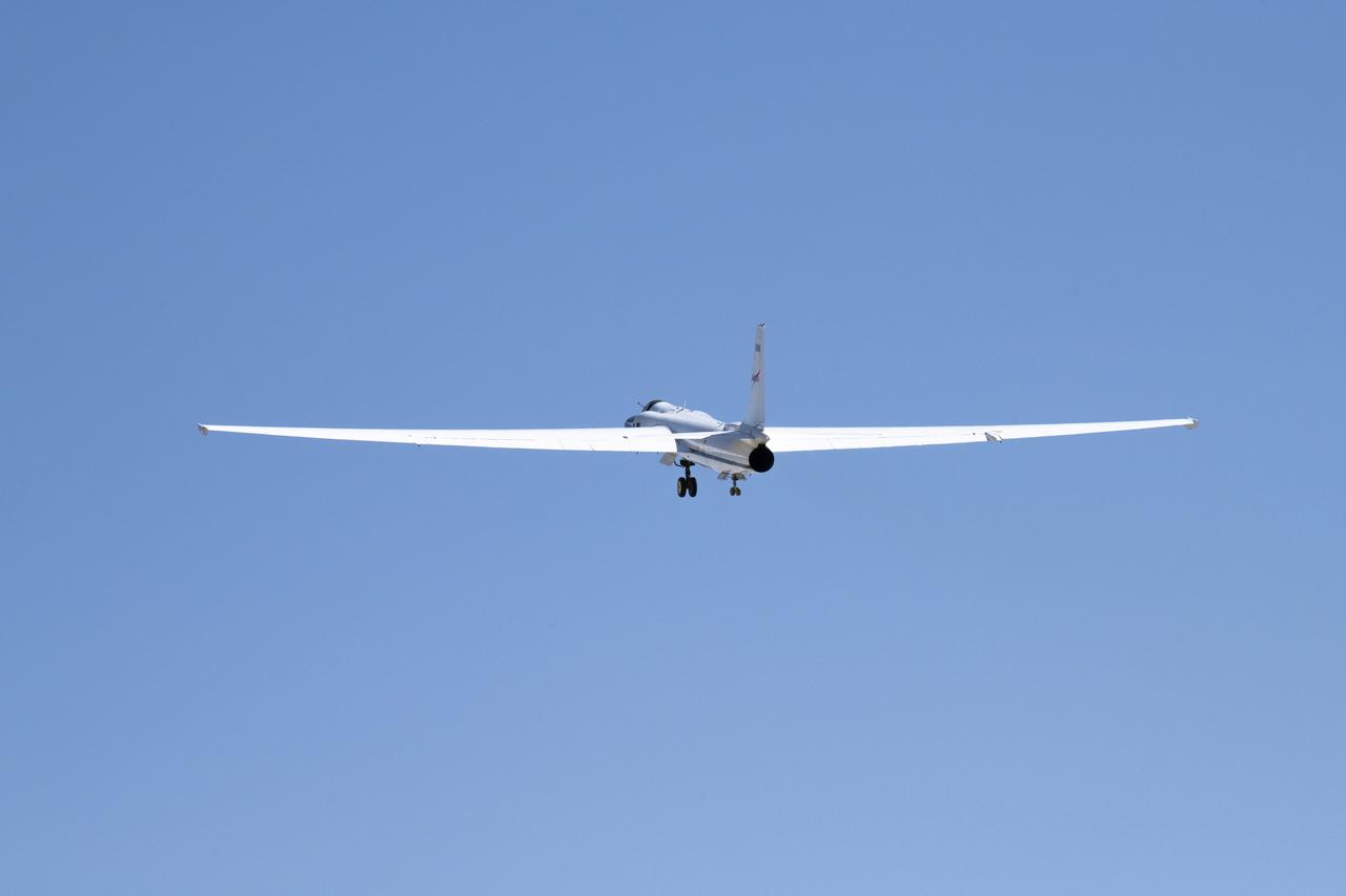
One of NASA's two ER-2 Earth resources aircraft shows off its lines during a flyover at the Edwards Air Force Base open house Oct. 28-29, 2006.
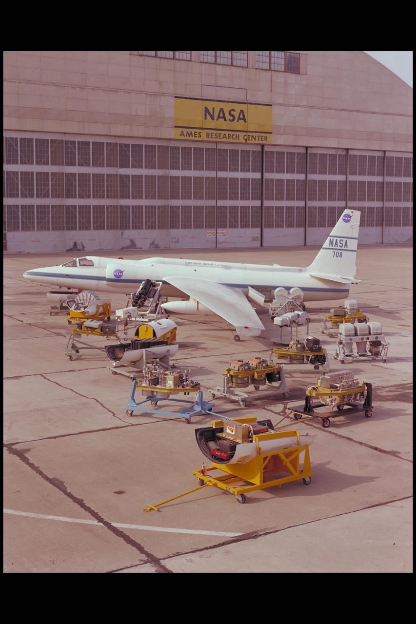
The U-2 Earth Resources Aircraft on the Ames tarmack surrounded by the on board sensors and camera systems
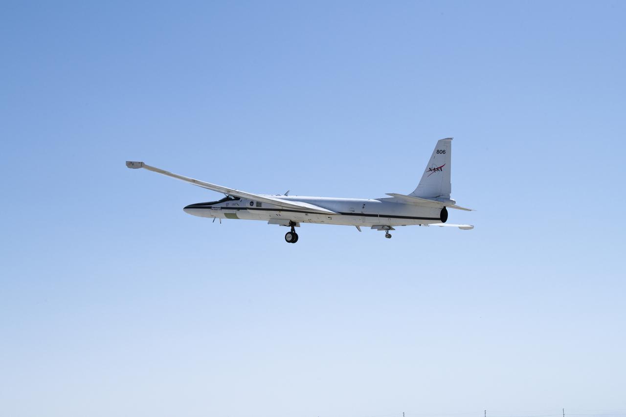
NASA’s ER-2 No. 806 returns to flying high-altitude on April 7, 2022, after three years of heavy maintenance. NASA Armstrong operates two ER-2 aircraft to collect information about Earth resources, celestial observations, atmospheric chemistry and dynamics, and oceanic processes.
NASA's ER-2 No. 806 returns to flying high-altitude on April 7, 2022, after three years of heavy maintenance. NASA Armstrong operates two ER-2 aircraft to collect information about Earth resources, celestial observations, atmospheric chemistry and dynamics, and oceanic processes.
NASA’s ER-2 No. 806 returns to flying high-altitude on April 7, 2022, after three years of heavy maintenance. NASA Armstrong operates two ER-2 aircraft to collect information about Earth resources, celestial observations, atmospheric chemistry and dynamics, and oceanic processes.
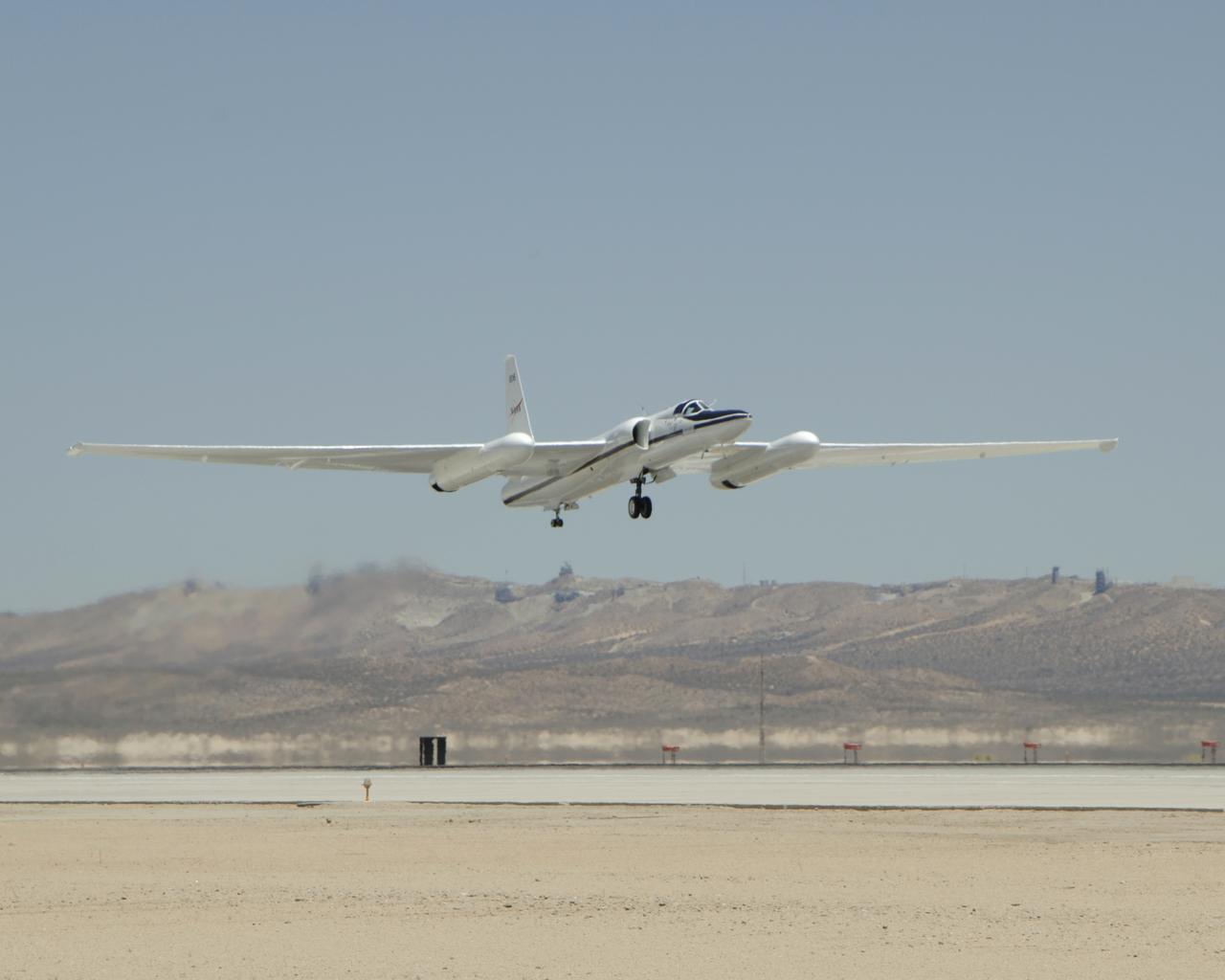
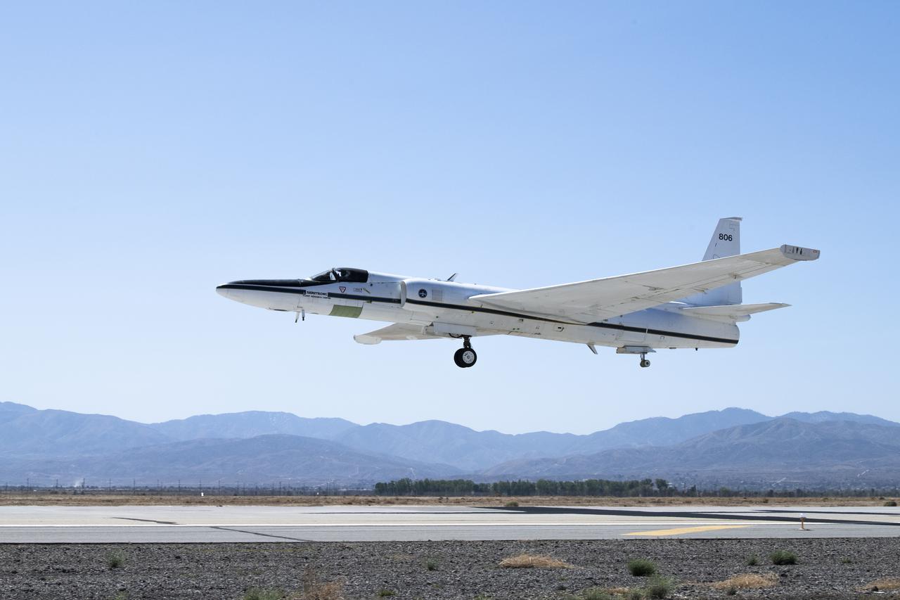
NASA'S ER-2 #806 lifts off from Edwards Air Force Base on a CALIPS/CloudSat validation instrument checkout flight.
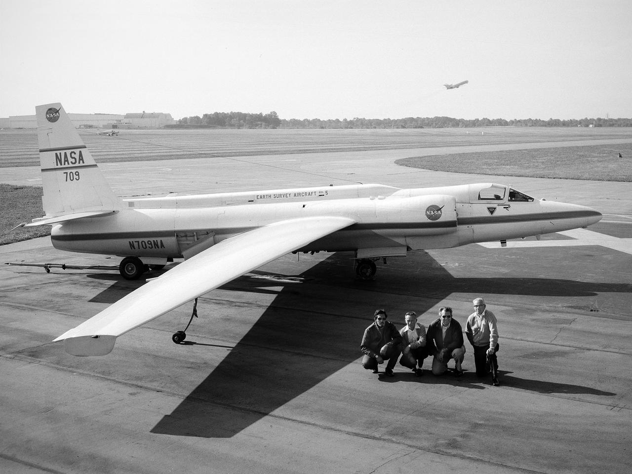
A National Aeronautics and Space Administration (NASA) Lockheed U-2 aircraft on display at the 1973 Inspection of the Lewis Research Center in Cleveland, Ohio. Lockheed developed the U-2 as a high-altitude reconnaissance aircraft in the early 1950s before satellites were available. The U-2 could cruise over enemy territory at 70,000 feet and remain impervious to ground fire, interceptor aircraft, and even radar. An advanced camera system was designed specifically for the aircraft. The pilot is required to use a pressure suit similar to those worn by astronauts. NASA’s Ames Research Center received two U-2 aircraft in April 1971 to conduct high-altitude research. They were used to study and monitor various Earth resources, celestial bodies, atmospheric chemistry, and oceanic processes. NASA replaced its U-2s with ER-2 aircraft in 1981 and 1989. The ER-2s were designed to carry up to 2600 pounds of scientific equipment. The ER-2 program was transferred to Dryden Flight Research Center in 1997. Since the inaugural flight for this program on August 31, 1971, NASA’s U-2 and ER-2 aircraft have flown more than 4500 data missions and test flights for NASA, other federal agencies, states, universities, and the private sector.

The National Aeronautics and Space Administration (NASA) Lewis Research Center acquired this Gulfstream C-131B Samaritan from the Air Force in July 1976. The center obtained the aircraft to support its current earth resources work. The C-131B is seen here inside the Lewis hangar being refurbished and converted into a flying laboratory. The modifications were led by Lewis Chief of Flight Operations Robert Hogan. The cockpit and cabin were modified and packed with instrumentation. The new equipment included Sideways Looking Airborne Radar (SLAR), geothermal sensors, radar antennas, and an inertial navigation system. In addition, portals were installed underneath the fuselage for cameras and remote sensing equipment. NASA’s C-131B was used to support researchers tracking ice flows on the Great Lakes and in Prudhoe Bay, Alaska. It was also used for the center’s program to determine heating losses in the Cleveland area’s residential and commercial structures. The aircraft was later donated to the University of Georgia.
This data was acquired by the NASA C-130B Earth Resources Survey aircraft flying at 6,000 ft. mean sea level at 10:26 a. m. on October 21, 1991. The sensor used was the NS001 Thermatic Mapper Simulator, with a ground resolution of 4.6 meters (15ft). The image area is 4.7 x 3.2 km (2.9 x 2 mi.). The area covered is the Oakland Berkeley Hills near the Caldecott Tunnel (Upper right). Targets over 600 degrees centrigrade are shown as yellow in this composite of three infrared bands (11.6, 2.3, & 1.6 microns). A large condominium complex at the upper right is completely consumed. Areas already burned off sow as pale red. The blue clouds at left are condensed water vapor within the smoke plume, which blocks the infrared wavelength; the smoke itself is transparent. Many hundreds of individual structures can be seen either actively burning or as heat of smouldering debris.
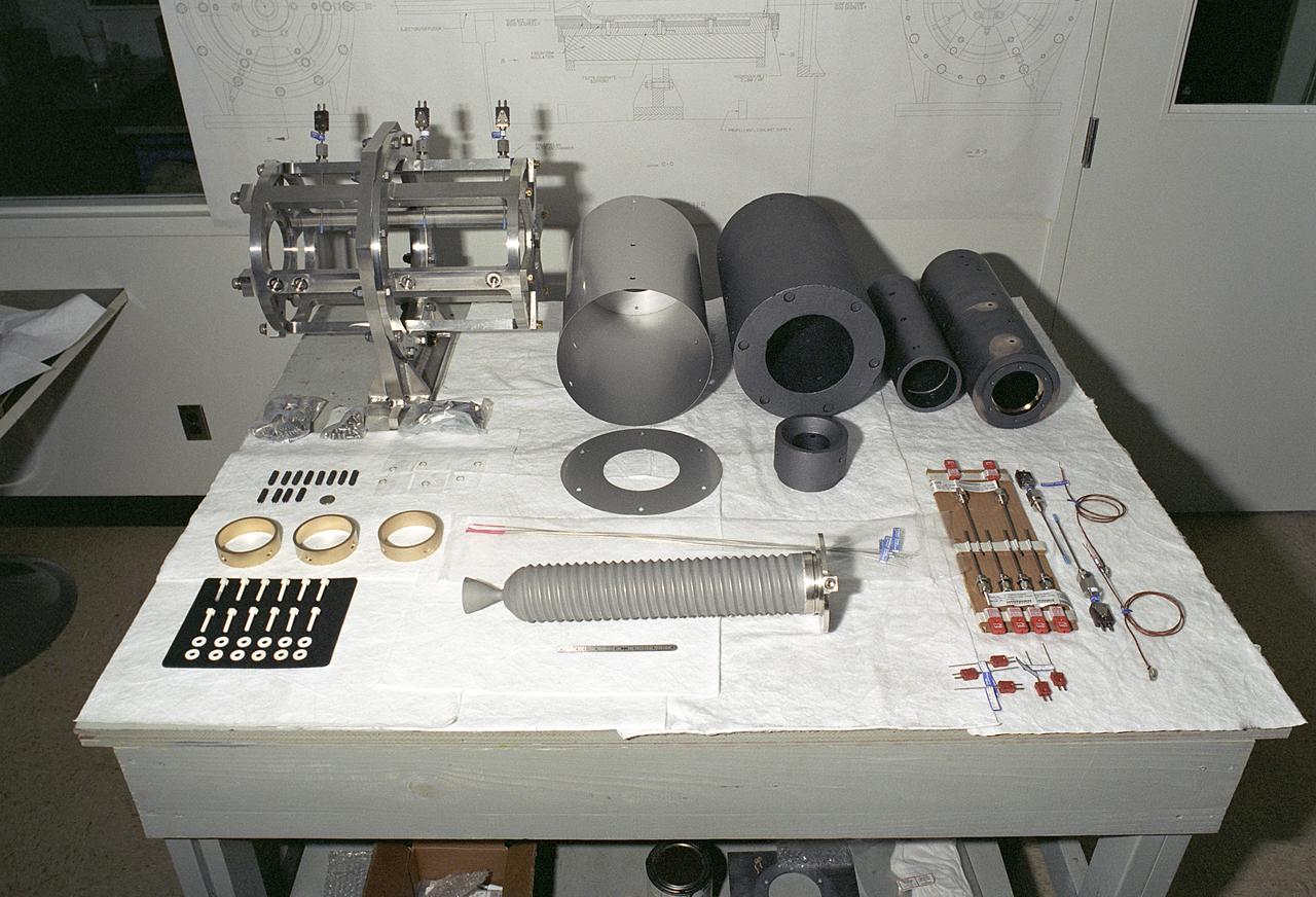
Researchers at the Marshall Space Flight Center (MSFC) have designed, fabricated, and tested the first solar thermal engine, a non-chemical rocket engine that produces lower thrust but has better thrust efficiency than a chemical combustion engine. This photograph shows components for the thermal propulsion engine being laid out prior to assembly. MSFC turned to solar thermal propulsion in the early 1990s due to its simplicity, safety, low cost, and commonality with other propulsion systems. As part of MSFC's Space Transportation Directorate, the Propulsion Research Center serves as a national resource for research of advanced, revolutionary propulsion technologies. The mission is to move the Nation's capabilities beyond the confines of conventional chemical propulsion into an era of aircraft-like access to Earth-orbit, rapid travel throughout the solar system, and exploration of interstellar space.
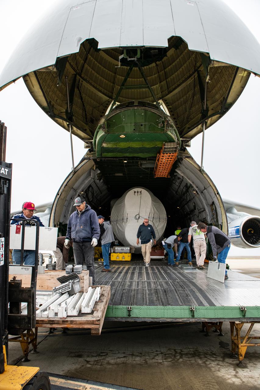
The United Launch Alliance (ULA) Atlas V booster for NASA’s Landsat 9 mission is offloaded from the Antonov 124 cargo aircraft and prepared for transport to the Horizontal Integration Facility at Vandenberg Space Force Base in California, on June 29, 2021. The Landsat 9 mission will launch atop a ULA Atlas V rocket from Vandenberg in September 2021. The launch is being managed by NASA’s Launch Services Program based at Kennedy Space Center. The Landsat 9 satellite will continue the nearly 50-year legacy of previous Landsat missions. It will monitor key natural and economic resources from orbit. Landsat 9 is managed by the agency’s Goddard Space Flight Center in Greenbelt, Maryland. The satellite will carry two instruments: the Operational Land Imager 2, which collects images of Earth’s landscapes in visible, near infrared and shortwave infrared light, and the Thermal Infrared Sensor 2, which measures the temperature of land surfaces. Like its predecessors, Landsat 9 is a joint mission between NASA and the U.S. Geological Survey.
The United Launch Alliance (ULA) Atlas V booster for NASA’s Landsat 9 mission is offloaded from the Antonov 124 cargo aircraft at Vandenberg Space Force Base in California, on June 29, 2021. The Landsat 9 mission will launch atop a ULA Atlas V rocket from Vandenberg in September 2021. The launch is being managed by NASA’s Launch Services Program based at Kennedy Space Center. The Landsat 9 satellite will continue the nearly 50-year legacy of previous Landsat missions. It will monitor key natural and economic resources from orbit. Landsat 9 is managed by the agency’s Goddard Space Flight Center in Greenbelt, Maryland. The satellite will carry two instruments: the Operational Land Imager 2, which collects images of Earth’s landscapes in visible, near infrared and shortwave infrared light, and the Thermal Infrared Sensor 2, which measures the temperature of land surfaces. Like its predecessors, Landsat 9 is a joint mission between NASA and the U.S. Geological Survey.
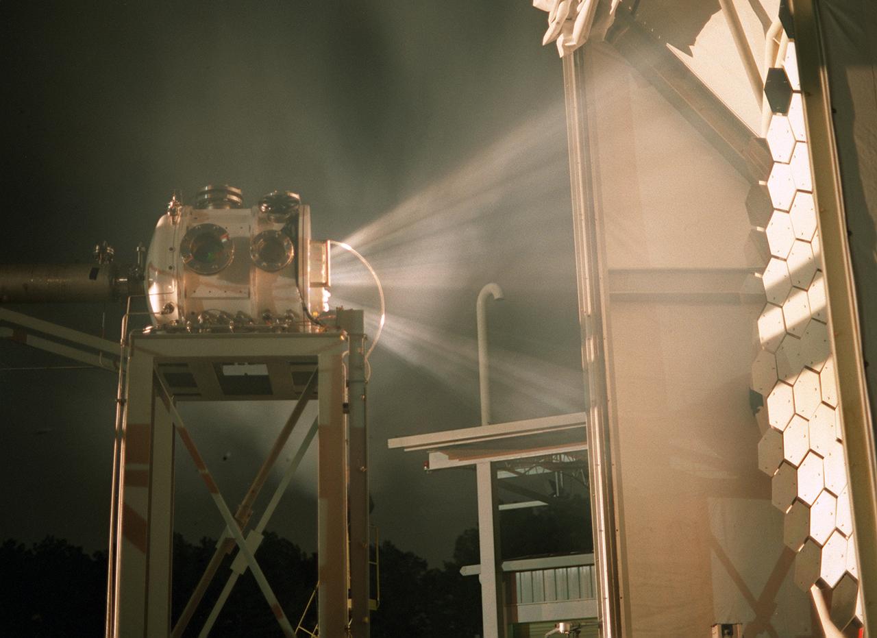
Researchers at the Marshall Space Flight Center (MSFC) have designed, fabricated, and tested the first solar thermal engine, a non-chemical rocket engine that produces lower thrust but has better thrust efficiency than a chemical combustion engine. MSFC turned to solar thermal propulsion in the early 1990s due to its simplicity, safety, low cost, and commonality with other propulsion systems. Solar thermal propulsion works by acquiring and redirecting solar energy to heat a propellant. The 20- by 24-ft heliostat mirror (not shown in this photograph) has a dual-axis control that keeps a reflection of the sunlight on the 18-ft diameter concentrator mirror, which then focuses the sunlight to a 4-in focal point inside the vacuum chamber. The focal point has 10 kilowatts of intense solar power. This image, taken during the test, depicts the light being concentrated into the focal point inside the vacuum chamber. As part of MSFC's Space Transportation Directorate, the Propulsion Research Center serves as a national resource for research of advanced, revolutionary propulsion technologies. The mission is to move the Nation's capabilities beyond the confines of conventional chemical propulsion into an era of aircraft-like access to Earth orbit, rapid travel throughout the solar system, and exploration of interstellar space.
The United Launch Alliance (ULA) Atlas V booster for NASA’s Landsat 9 mission arrives aboard an Antonov 124 cargo aircraft at Vandenberg Space Force Base in California, on June 28, 2021. The Landsat 9 mission will launch atop a ULA Atlas V rocket from Vandenberg in September 2021. The launch is being managed by NASA’s Launch Services Program based at Kennedy Space Center. The Landsat 9 satellite will continue the nearly 50-year legacy of previous Landsat missions. It will monitor key natural and economic resources from orbit. Landsat 9 is managed by the agency’s Goddard Space Flight Center in Greenbelt, Maryland. The satellite will carry two instruments: the Operational Land Imager 2, which collects images of Earth’s landscapes in visible, near infrared and shortwave infrared light, and the Thermal Infrared Sensor 2, which measures the temperature of land surfaces. Like its predecessors, Landsat 9 is a joint mission between NASA and the U.S. Geological Survey.
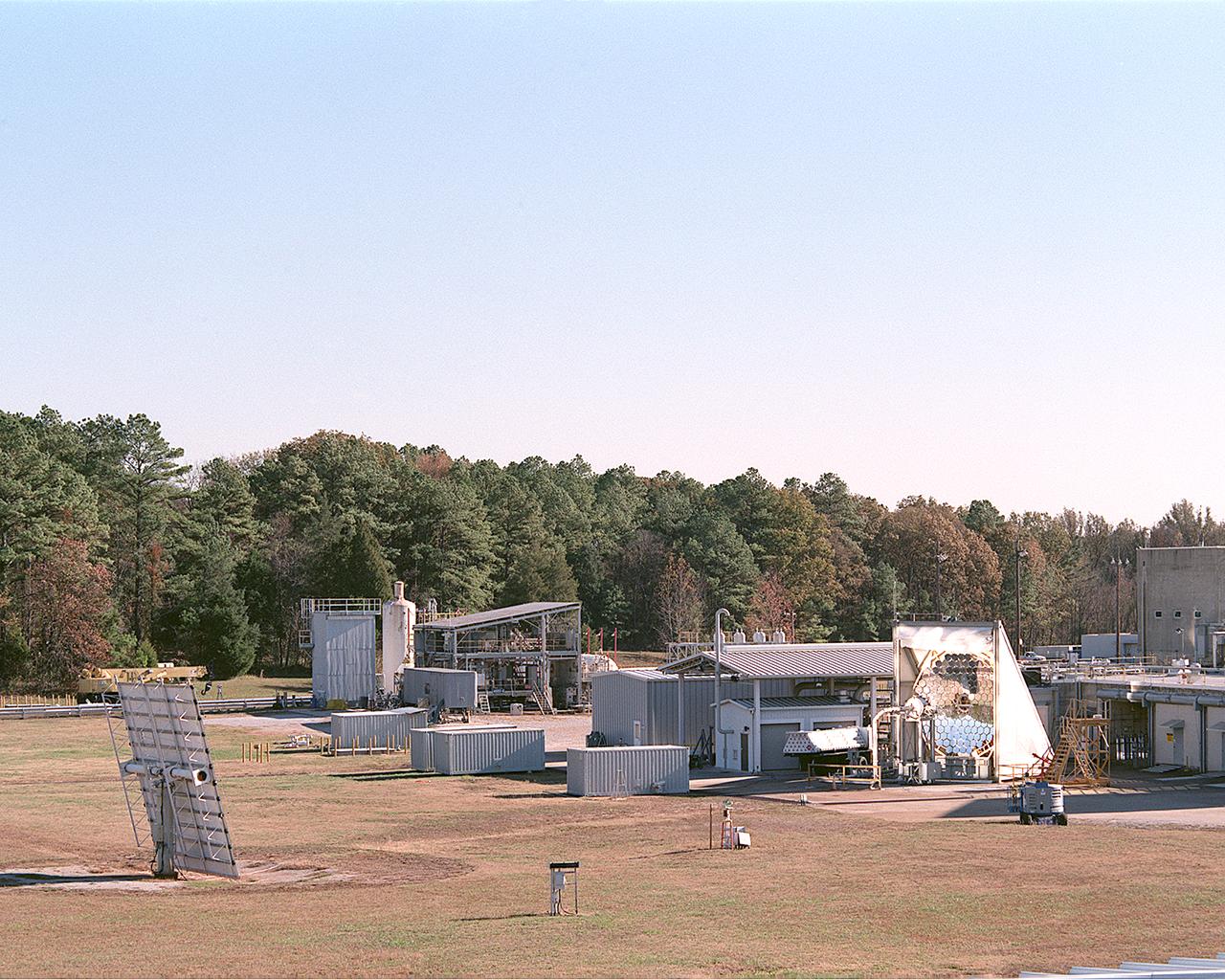
Researchers at the Marshall Space Flight Center (MSFC) have designed, fabricated and tested the first solar thermal engine, a non-chemical rocket engine that produces lower thrust but has better thrust efficiency than a chemical combustion engine. MSFC turned to solar thermal propulsion in the early 1990s due to its simplicity, safety, low cost, and commonality with other propulsion systems. Solar thermal propulsion works by acquiring and redirecting solar energy to heat a propellant. This photograph, taken at MSFC's Solar Thermal Propulsion Test Facility, shows a concentrator mirror, a combination of 144 mirrors forming this 18-ft diameter concentrator, and a vacuum chamber that houses the focal point. The 20- by 24-ft heliostat mirror (not shown in this photograph) has a dual-axis control that keeps a reflection of the sunlight on the 18-foot diameter concentrator mirror, which then focuses the sunlight to a 4-in focal point inside the vacuum chamber. The focal point has 10 kilowatts of intense solar power. As part of MSFC's Space Transportation Directorate, the Propulsion Research Center serves as a national resource for research of advanced, revolutionary propulsion technologies. The mission is to move the Nation's capabilities beyond the confines of conventional chemical propulsion into an era of aircraft-like access to Earth-orbit, rapid travel throughout the solar system, and exploration of interstellar space.
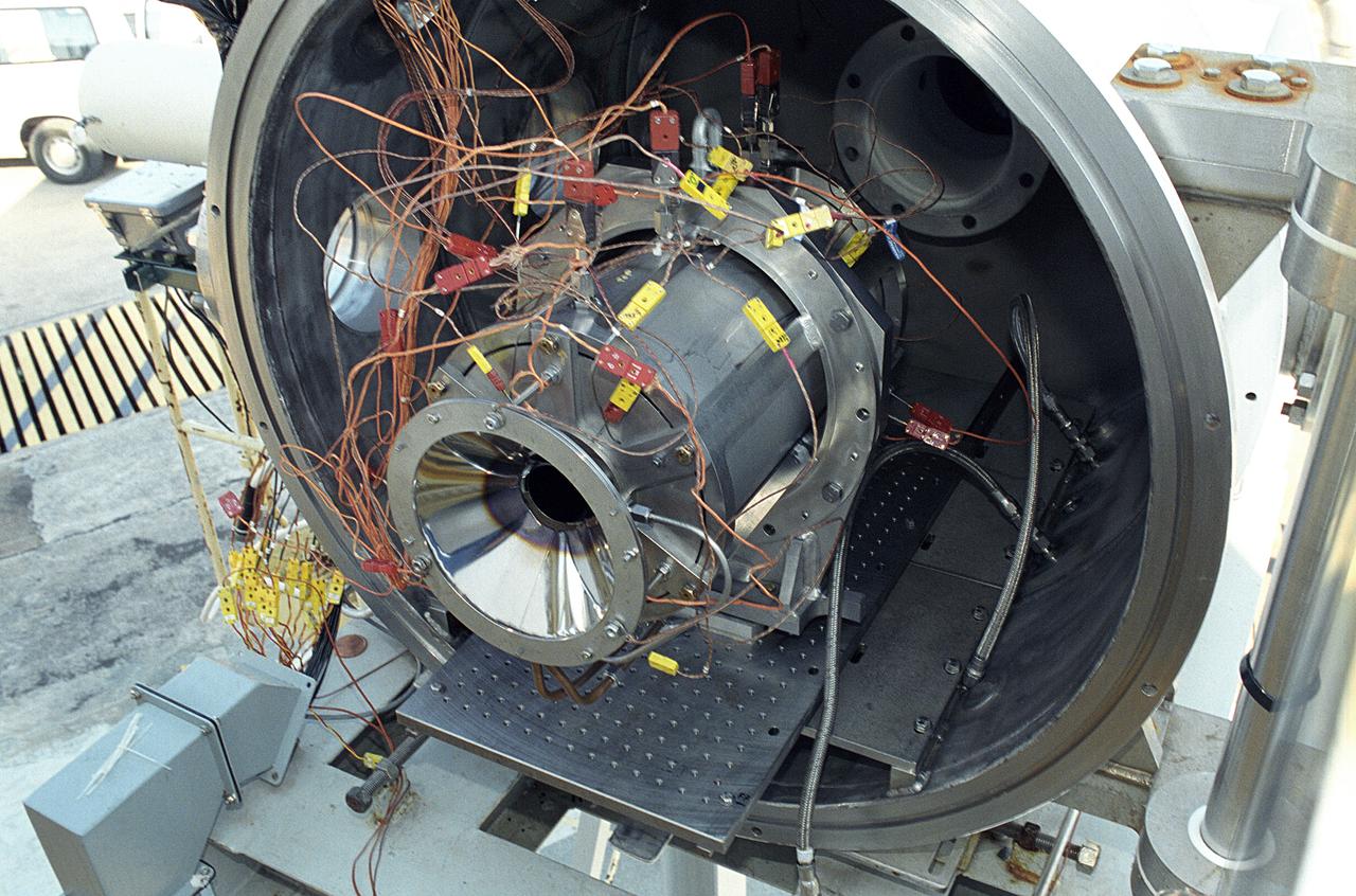
Researchers at the Marshall Space Flight Center (MSFC) have designed, fabricated, and tested the first solar thermal engine, a non-chemical rocket engine that produces lower thrust but has better thrust efficiency than a chemical combustion engine. MSFC turned to solar thermal propulsion in the early 1990s due to its simplicity, safety, low cost, and commonality with other propulsion systems. Solar thermal propulsion works by acquiring and redirecting solar energy to heat a propellant. This photograph shows a fully assembled solar thermal engine placed inside the vacuum chamber at the test facility prior to testing. The 20- by 24-ft heliostat mirror (not shown in this photograph) has a dual-axis control that keeps a reflection of the sunlight on the 18-ft diameter concentrator mirror, which then focuses the sunlight to a 4-in focal point inside the vacuum chamber. The focal point has 10 kilowatts of intense solar power. As part of MSFC's Space Transportation Directorate, the Propulsion Research Center serves as a national resource for research of advanced, revolutionary propulsion technologies. The mission is to move theNation's capabilities beyond the confines of conventional chemical propulsion into an era of aircraft-like access to Earth orbit, rapid travel throughout the solar system, and exploration of interstellar space.
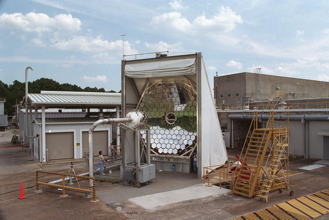
This photograph shows an overall view of the Solar Thermal Propulsion Test Facility at the Marshall Space Flight Center (MSFC). The 20-by 24-ft heliostat mirror, shown at the left, has dual-axis control that keeps a reflection of the sunlight on an 18-ft diameter concentrator mirror (right). The concentrator mirror then focuses the sunlight to a 4-in focal point inside the vacuum chamber, shown at the front of concentrator mirror. Researchers at MSFC have designed, fabricated, and tested the first solar thermal engine, a non-chemical rocket engine that produces lower thrust but has better thrust efficiency than chemical a combustion engine. MSFC turned to solar thermal propulsion in the early 1990s due to its simplicity, safety, low cost, and commonality with other propulsion systems. Solar thermal propulsion works by acquiring and redirecting solar energy to heat a propell nt. As part of MSFC's Space Transportation Directorate, the Propulsion Research Center serves as a national resource for research of advanced, revolutionary propulsion technologies. The mission is to move the Nation's capabilities beyond the confines of conventional chemical propulsion into an era of aircraft-like access to Earth-orbit, rapid travel throughout the solar system, and exploration of interstellar space.

The United Launch Alliance (ULA) Atlas V booster for NASA’s Landsat 9 mission arrives aboard an Antonov 124 cargo aircraft at Vandenberg Space Force Base in California, on June 28, 2021. The Landsat 9 mission will launch atop a ULA Atlas V rocket from Vandenberg in September 2021. The launch is being managed by NASA’s Launch Services Program based at Kennedy Space Center. The Landsat 9 satellite will continue the nearly 50-year legacy of previous Landsat missions. It will monitor key natural and economic resources from orbit. Landsat 9 is managed by the agency’s Goddard Space Flight Center in Greenbelt, Maryland. The satellite will carry two instruments: the Operational Land Imager 2, which collects images of Earth’s landscapes in visible, near infrared and shortwave infrared light, and the Thermal Infrared Sensor 2, which measures the temperature of land surfaces. Like its predecessors, Landsat 9 is a joint mission between NASA and the U.S. Geological Survey.

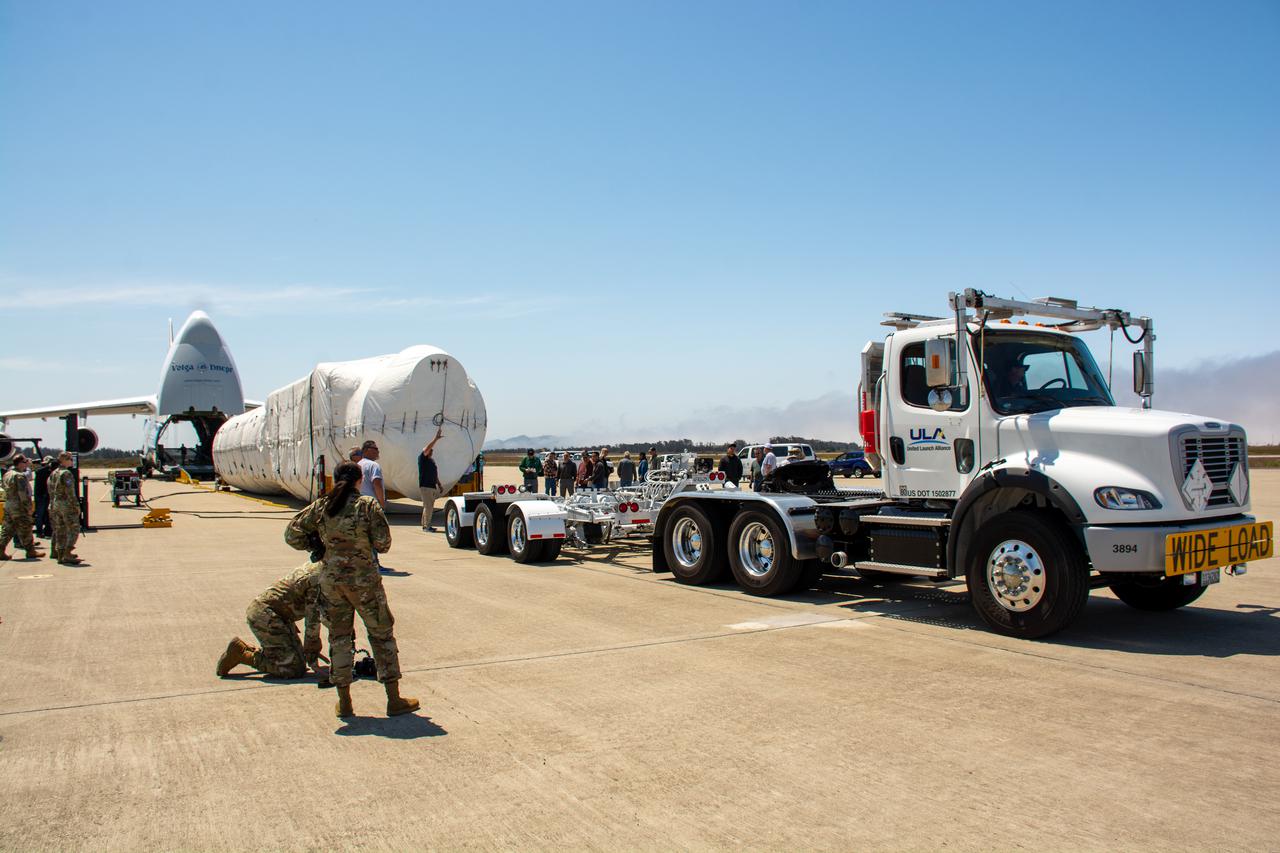
An Antonov 124 cargo aircraft touches down at Vandenberg Space Force Base in California on June 28, 2021, carrying the United Launch Alliance (ULA) Atlas V booster for NASA’s Landsat 9 mission. The Landsat 9 mission will launch atop a ULA Atlas V rocket from Vandenberg in September 2021. The launch is being managed by NASA’s Launch Services Program based at Kennedy Space Center. The Landsat 9 satellite will continue the nearly 50-year legacy of previous Landsat missions. It will monitor key natural and economic resources from orbit. Landsat 9 is managed by the agency’s Goddard Space Flight Center in Greenbelt, Maryland. The satellite will carry two instruments: the Operational Land Imager 2, which collects images of Earth’s landscapes in visible, near infrared and shortwave infrared light, and the Thermal Infrared Sensor 2, which measures the temperature of land surfaces. Like its predecessors, Landsat 9 is a joint mission between NASA and the U.S. Geological Survey.
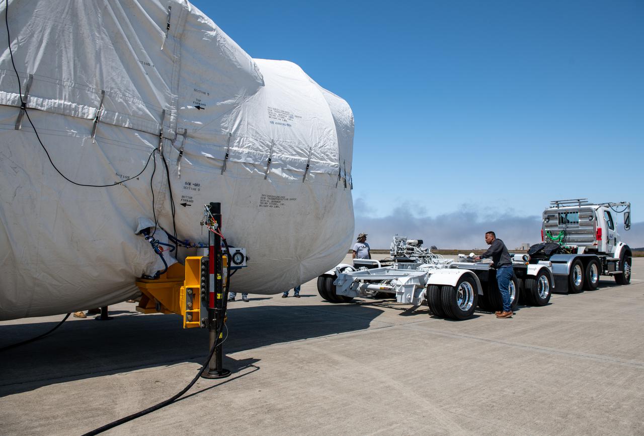
The United Launch Alliance (ULA) Atlas V booster for NASA’s Landsat 9 mission is offloaded from the Antonov 124 cargo aircraft at Vandenberg Space Force Base in California, on June 29, 2021 and prepared for transport to the Horizontal Integration Facility. The Landsat 9 mission will launch atop a ULA Atlas V rocket from Vandenberg in September 2021. The launch is being managed by NASA’s Launch Services Program based at Kennedy Space Center. The Landsat 9 satellite will continue the nearly 50-year legacy of previous Landsat missions. It will monitor key natural and economic resources from orbit. Landsat 9 is managed by the agency’s Goddard Space Flight Center in Greenbelt, Maryland. The satellite will carry two instruments: the Operational Land Imager 2, which collects images of Earth’s landscapes in visible, near infrared and shortwave infrared light, and the Thermal Infrared Sensor 2, which measures the temperature of land surfaces. Like its predecessors, Landsat 9 is a joint mission between NASA and the U.S. Geological Survey.

The United Launch Alliance (ULA) Atlas V booster for NASA’s Landsat 9 mission is offloaded from the Antonov 124 cargo aircraft at Vandenberg Space Force Base in California, on June 29, 2021. The Landsat 9 mission will launch atop a ULA Atlas V rocket from Vandenberg in September 2021. The launch is being managed by NASA’s Launch Services Program based at Kennedy Space Center. The Landsat 9 satellite will continue the nearly 50-year legacy of previous Landsat missions. It will monitor key natural and economic resources from orbit. Landsat 9 is managed by the agency’s Goddard Space Flight Center in Greenbelt, Maryland. The satellite will carry two instruments: the Operational Land Imager 2, which collects images of Earth’s landscapes in visible, near infrared and shortwave infrared light, and the Thermal Infrared Sensor 2, which measures the temperature of land surfaces. Like its predecessors, Landsat 9 is a joint mission between NASA and the U.S. Geological Survey.
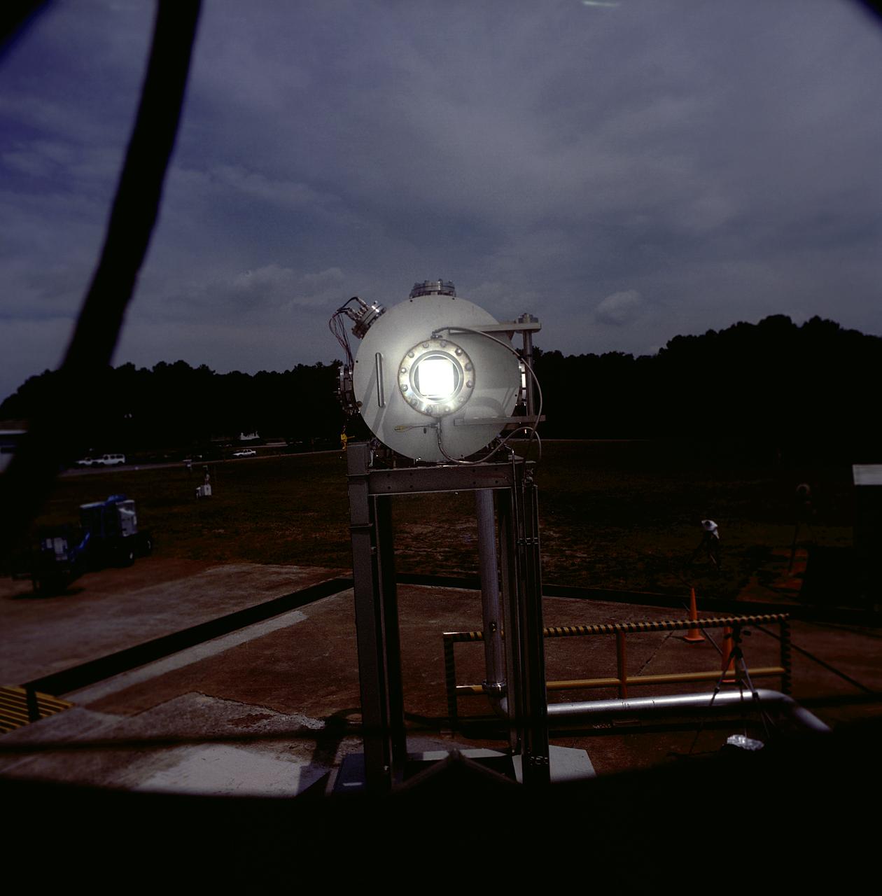
Researchers at the Marshall Space Flight Center (MSFC) have designed, fabricated, and tested the first solar thermal engine, a non-chemical rocket engine that produces lower thrust but has better thrust efficiency than a chemical combustion engine. MSFC turned to solar thermal propulsion in the early 1990s due to its simplicity, safety, low cost, and commonality with other propulsion systems. Solar thermal propulsion works by acquiring and redirecting solar energy to heat a propellant. The 20- by 24-ft heliostat mirror (not shown in this photograph) has dual-axis control that keeps a reflection of the sunlight on an 18-ft diameter concentrator mirror, which then focuses the sunlight to a 4-in focal point inside the vacuum chamber. The focal point has 10 kilowatts of intense solar power. This photograph is a close-up view of a 4-in focal point inside the vacuum chamber at the MSFC Solar Thermal Propulsion Test facility. As part of MSFC's Space Transportation Directorate, the Propulsion Research Center serves as a national resource for research of advanced, revolutionary propulsion technologies. The mission is to move the Nation's capabilities beyond the confines of conventional chemical propulsion into an era of aircraft-like access to Earth orbit, rapid travel throughout the solar system, and exploration of interstellar space.
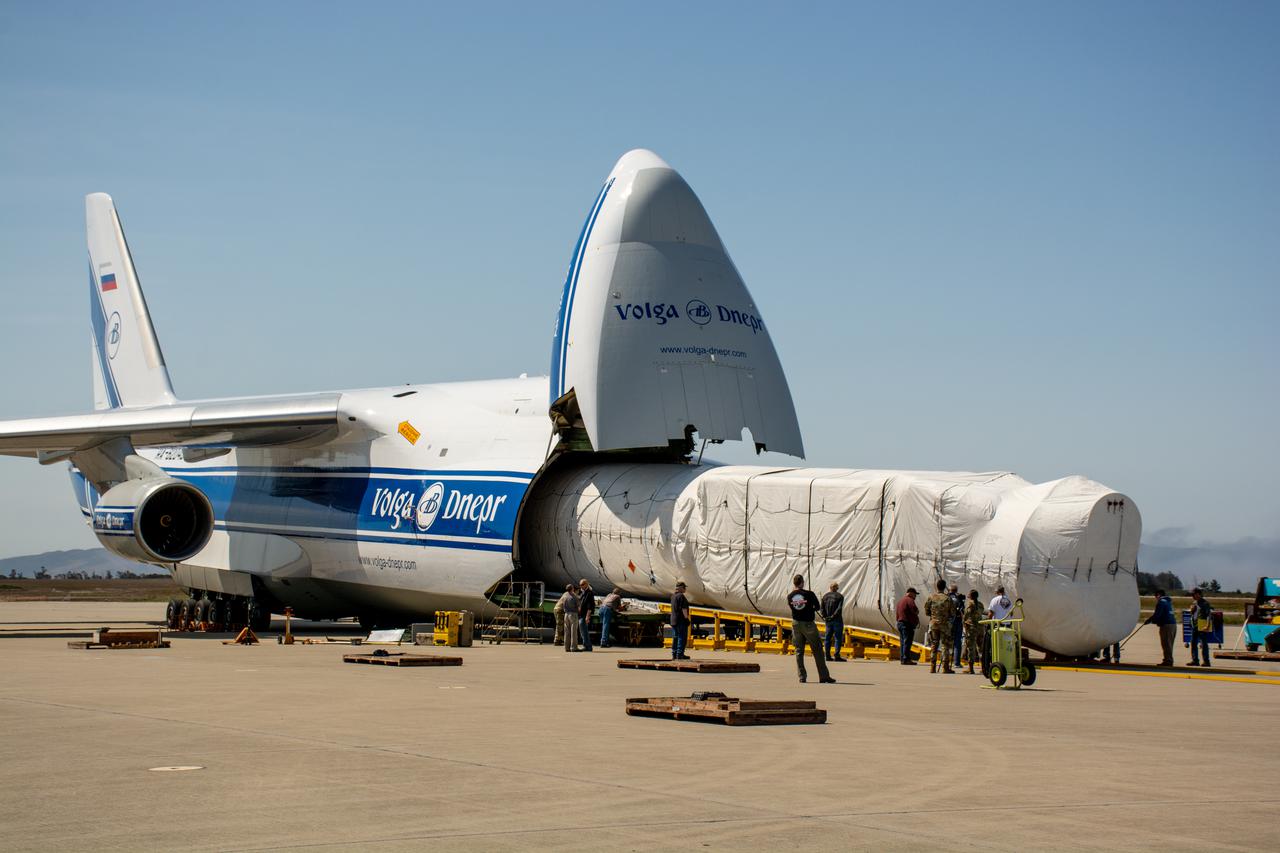
The United Launch Alliance (ULA) Atlas V booster for NASA’s Landsat 9 mission is offloaded from the Antonov 124 cargo aircraft at Vandenberg Space Force Base in California, on June 29, 2021. The Landsat 9 mission will launch atop a ULA Atlas V rocket from Vandenberg in September 2021. The launch is being managed by NASA’s Launch Services Program based at Kennedy Space Center. The Landsat 9 satellite will continue the nearly 50-year legacy of previous Landsat missions. It will monitor key natural and economic resources from orbit. Landsat 9 is managed by the agency’s Goddard Space Flight Center in Greenbelt, Maryland. The satellite will carry two instruments: the Operational Land Imager 2, which collects images of Earth’s landscapes in visible, near infrared and shortwave infrared light, and the Thermal Infrared Sensor 2, which measures the temperature of land surfaces. Like its predecessors, Landsat 9 is a joint mission between NASA and the U.S. Geological Survey.

James Barrilleaux is the assistant chief pilot for ER-2s in the Flight Crew Branch of NASA's Dryden Flight Research Center, Edwards, California. The ER-2s--civilian variants of the military U-2S reconnaissance aircraft--are part of NASA's Airborne Science program. The ER-2s can carry airborne scientific payloads of up to 2,600 pounds to altitudes of about 70,000 feet to investigate such matters as earth resources, celestial phenomena, atmospheric chemistry and dynamics, and oceanic processes. Barrilleaux has held his current position since February 1998. Barrilleaux joined NASA in 1986 as a U-2/ER-2 pilot with NASA's Airborne Science program at Ames Research Center, Moffett Field, California. He flew both the U-2C (until 1989) and the ER-2 on a wide variety of missions both domestic and international. Barrilleaux flew high-altitude operations over Antarctica in which scientific instruments aboard the ER-2 defined the cause of ozone depletion over the continent, known as the ozone hole. He has also flown the ER-2 over the North Pole. Barrilleaux served for 20 years in the U.S. Air Force before he joined NASA. He completed pilot training at Reese Air Force Base, Lubbock, Texas, in 1966. He flew 120 combat missions as a F-4 fighter pilot over Laos and North Vietnam in 1970 and 1971. He joined the U-2 program in 1974, becoming the commander of an overseas U-2 operation in 1982. In 1983, he became commander of the squadron responsible for training all U-2 pilots and SR-71 crews located at Beale Air Force Base, Marysville, California. He retired from the Air Force as a lieutenant colonel in 1986. On active duty, he flew the U-2, F-4 Phantom, the T-38, T-37, and the T-33. His decorations included two Distinguished Flying Crosses, 12 Air Medals, two Meritorious Service Medals, and other Air Force and South Vietnamese awards. Barrilleaux earned a bachelor of science degree in chemical engineering from Texas A&M University, College Station, in 1964 and a master of science
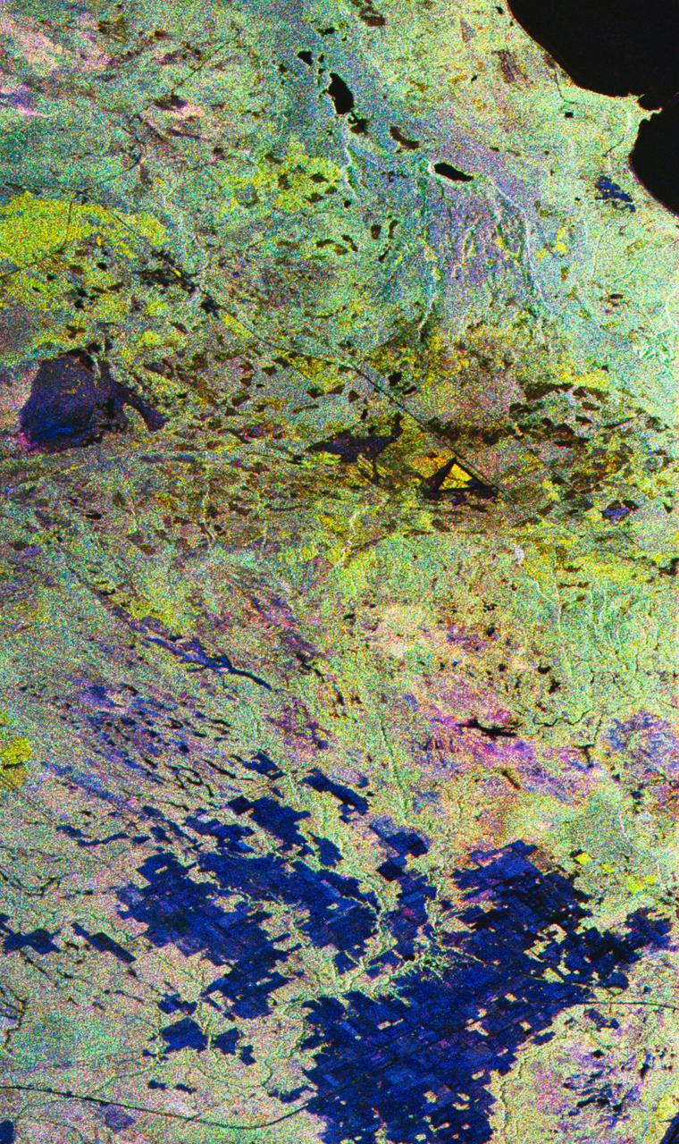
STS059-S-027 (10 April 1994) --- This image is a false-color composite of Raco, Michigan, centered at 46.39 degrees north latitude, 84.88 degrees east longitude. This image was acquired by the Spaceborne Imaging Radar-C and X-Band Synthetic Aperture Radar (SIR-C/X-SAR) aboard the Space Shuttle Endeavour on its 6th orbit and during the first full-capacity test of the instrument. This image was produced using both L-Band and C-Band data. The area shown is approximately 20 kilometers by 50 kilometers. Raco is located at the eastern end of Michigan's upper peninsula, west of Sault Ste. Marie and south of Whitefish Bay on Lake Superior. The site is located at the boundary between the boreal forests and the northern temperate forests, a transitional zone that is expected to be ecologically sensitive to anticipated global changes resulting from climatic warming. On any given day, there is a 60 percent chance that this area will be obscured to some extent by cloud cover which makes it difficult to image using optical sensors. In this color representation (Red=LHH, Green=LHV, Blue=CHH), darker areas in the image are smooth surfaces such as frozen lakes and other non-forested areas. The colors are related to the types of trees and the brightness is related to the amount of plant material covering the surface, called forest biomass. Accurate information about land-cover is important to area resource managers and for use in regional- to global-scale scientific models used to understand global change. SIR-C/X-SAR radars illuminate Earth with microwaves allowing detailed observations at any time, regardless of weather or sunlight conditions. SIR-C/X-SAR uses three microwave wavelengths: L-Band (24 cm), C-Band (6 cm), and X-Band (3 cm). The multi-frequency data will be used by the international scientific community to better understand the global environment and how it is changing. The SIR-C/X-SAR data, complemented by aircraft and ground studies, will give scientists clearer insights into those environmental changes which are caused by nature and those changes which are induced by human activity. SIR-C was developed by NASA's Jet Propulsion Laboratory (JPL). X-SAR was developed by the Dornire and Alenia Spazio Companies for the German Space Agency, Deutsche Agentur fuer Raumfahrtangelegenheiten (DARA), and the Italian Space Agency, Agenzia Spaziale Italiana (ASI). JPL Photo ID: P-43882
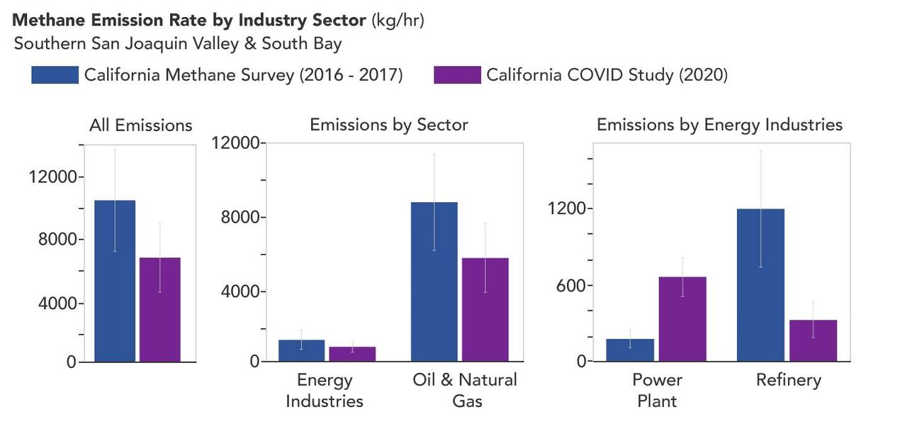
A March 2023 study by researchers at NASA's Jet Propulsion Laboratory in Southern California compared emissions from a belt of oil refineries across the South Bay area of Los Angeles during the first summer of the COVID-19 pandemic to those observed three years earlier. Using data from a NASA airborne instrument, researchers saw that most of the facilities they identified as methane sources in 2016-17 were no longer emitting the greenhouse gas in 2020, leading to a 73% reduction in measured emissions. The study uses measurements made by an imaging spectrometer called AVIRIS-NG (Airborne Visible/Infrared Imaging Spectrometer-Next Generation). Attached to the bottom of an aircraft, the instrument can detect greenhouse gas emissions from individual facilities or even pieces of equipment by looking at how the gases absorb sunlight. In 2016 and 2017, AVIRIS-NG was flown over 22,000 square miles (57,000 square kilometers) of the state as part of the California Methane Survey. From July to September 2020, researchers retraced some of those flight paths over refineries and power plants in Los Angeles County and over oil fields in central California's San Joaquin Valley. The flights were funded by NASA's Earth Science Division, the California Air Resources Board, and the California Energy Commission. The 2020 surveys over Los Angeles identified only 11 plumes from five refinery sources, with a total emissions rate of about 712 pounds (323 kilograms) methane per hour. The 2016 and 2017 flights had found 48 plumes from 33 sources, with a total emissions rate of roughly 2,639 pounds (1,197 kilograms) methane per hour. The drop correlates with an 18% decrease in monthly production in Southern California refineries between the two flight campaigns, the scientists noted, citing data from the California Energy Commission. The study also found that emissions from oil fields in and around the city of Bakersfield in central California fell 34.2%, correlating with a 24.2% drop in oil production. Reduced production during the pandemic due to lower demand for fuel and lower gas prices could have led to the drop in methane emissions, as oil fields and refineries emitted less methane as part of operations. However, researchers said, improved equipment maintenance and mitigation efforts at those facilities between 2016 and 2020 can't be ruled out as a factor. https://photojournal.jpl.nasa.gov/catalog/PIA25864