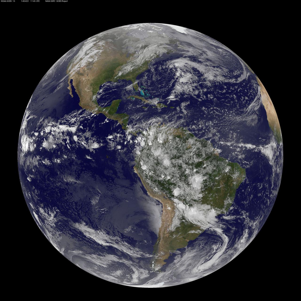
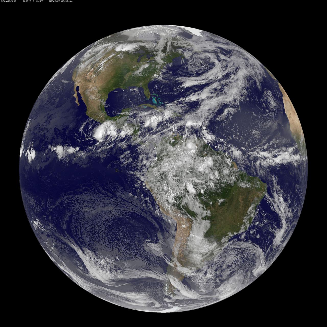
Today, April 22, 2014 is Earth Day, and what better way to celebrate than taking a look at our home planet from space. NOAA's GOES-East satellite captured this stunning view of the Americas on Earth Day, April 22, 2014 at 11:45 UTC/7:45 a.m. EDT. The data from GOES-East was made into an image by the NASA/NOAA GOES Project at NASA's Goddard Space Flight Center in Greenbelt, Md. In North America, clouds associated with a cold front stretch from Montreal, Canada, south through the Tennessee Valley, and southwest to southern Texas bringing rain east of the front today. A low pressure area in the Pacific Northwest is expected to bring rainfall in Oregon, Washington, Idaho, stretching into the upper Midwest, according to NOAA's National Weather Service. That low is also expected to bring precipitation north into the provinces of British Columbia and Alberta, Canada. Another Pacific low is moving over southern Nevada and the National Weather Service expects rain from that system to fall in central California, Nevada, and northern Utah. Near the equator, GOES imagery shows a line of pop up thunderstorms. Those thunderstorms are associated with the Intertropical Convergence Zone (ITCZ). The ITCZ encircles the Earth near the equator. In South America, convective (rapidly rising air that condenses and forms clouds) thunderstorms pepper Colombia, Venezuela, Ecuador, Peru, Bolivia, Paraguay and northwestern and southeastern Brazil. GOES satellites provide the kind of continuous monitoring necessary for intensive data analysis. Geostationary describes an orbit in which a satellite is always in the same position with respect to the rotating Earth. This allows GOES to hover continuously over one position on Earth's surface, appearing stationary. As a result, GOES provide a constant vigil for the atmospheric "triggers" for severe weather conditions such as tornadoes, flash floods, hail storms and hurricanes. For more information about GOES satellites, visit: <a href="http://www.goes.noaa.gov/" rel="nofollow">www.goes.noaa.gov/</a> or <a href="http://goes.gsfc.nasa.gov/" rel="nofollow">goes.gsfc.nasa.gov/</a> Rob Gutro NASA's Goddard Space Flight Center <b><a href="http://www.nasa.gov/audience/formedia/features/MP_Photo_Guidelines.html" rel="nofollow">NASA image use policy.</a></b> <b><a href="http://www.nasa.gov/centers/goddard/home/index.html" rel="nofollow">NASA Goddard Space Flight Center</a></b> enables NASA’s mission through four scientific endeavors: Earth Science, Heliophysics, Solar System Exploration, and Astrophysics. Goddard plays a leading role in NASA’s accomplishments by contributing compelling scientific knowledge to advance the Agency’s mission. <b>Follow us on <a href="http://twitter.com/NASAGoddardPix" rel="nofollow">Twitter</a></b> <b>Like us on <a href="http://www.facebook.com/pages/Greenbelt-MD/NASA-Goddard/395013845897?ref=tsd" rel="nofollow">Facebook</a></b> <b>Find us on <a href="http://instagram.com/nasagoddard?vm=grid" rel="nofollow">Instagram</a></b>

Hubble Captures Best View of Mars Ever Obtained from Earth

iss058e005282 (Jan. 19, 2019) --- A portion of the International Space Station's solar arrays caps this nighttime view of the Earth's limb with an aurora as the orbital complex orbited 258 miles above Ukraine and Russia.

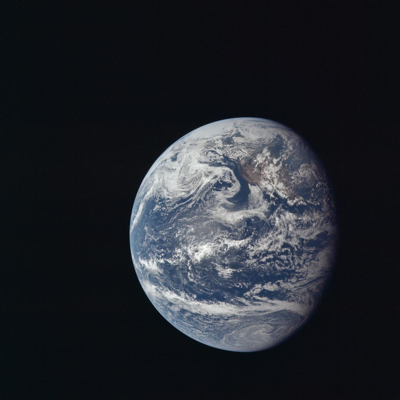
This is the first image of Earth ever taken from another planet that actually shows our home as a planetary disk. Because Earth and the Moon are closer to the Sun than Mars, they exhibit phases, just as the Moon, Venus, & Mercury do when viewed from Earth
View from side windows of Earth on Orion's first flight test, Exploration Flight Test-1 (EFT-1), on December 5, 2014.

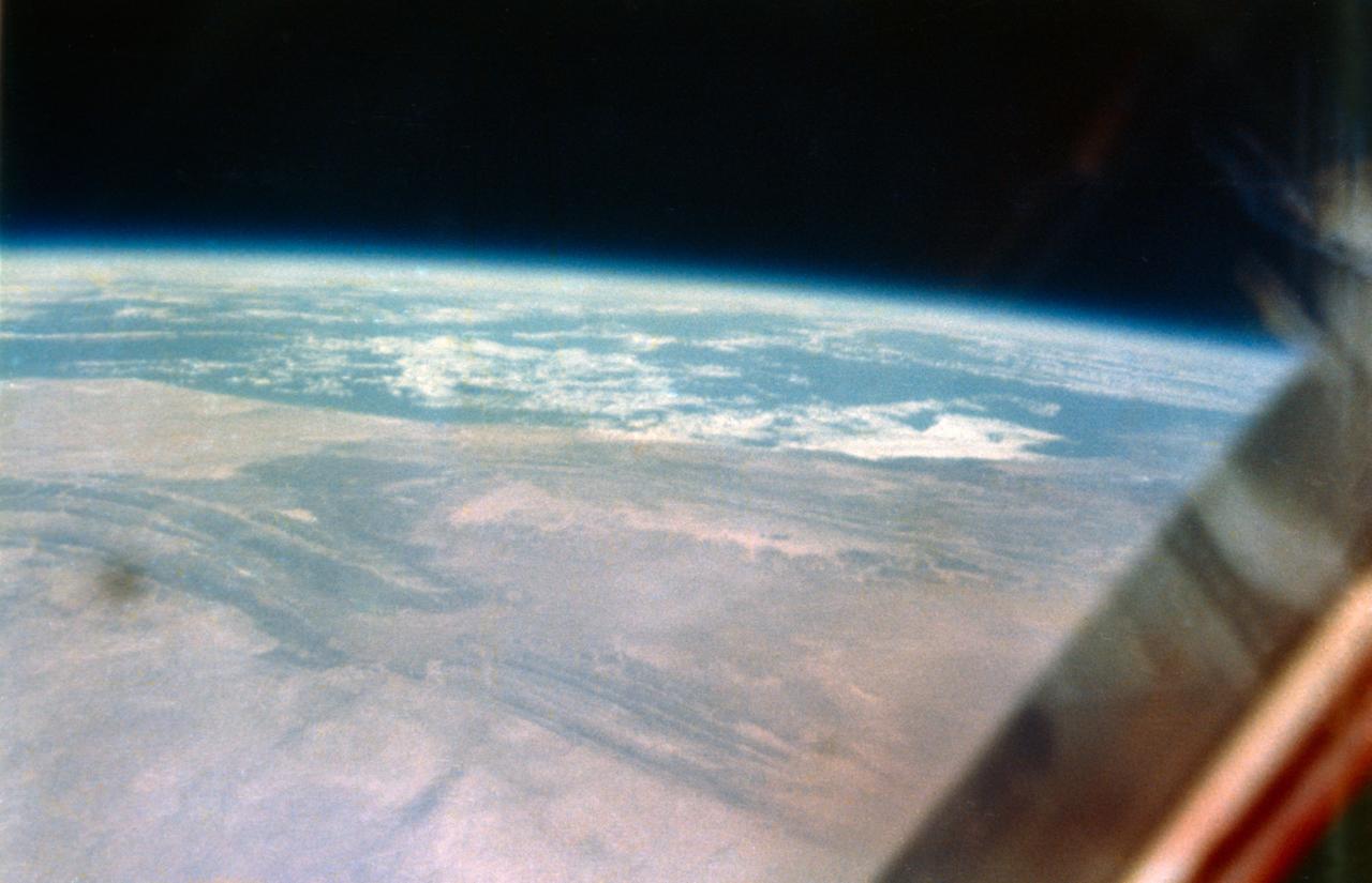
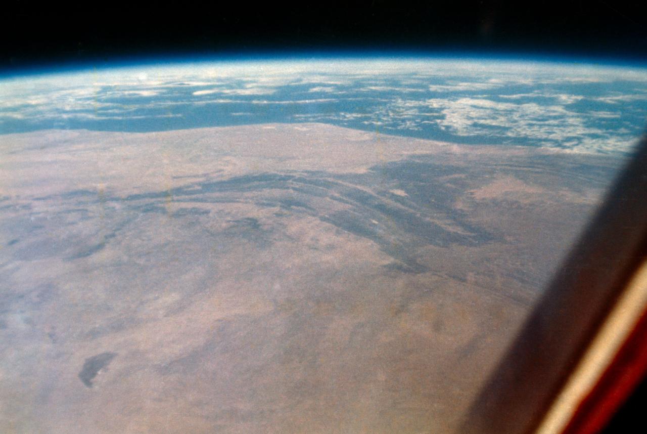
This composite image of southern Africa and the surrounding oceans was captured by six orbits of the NASA/NOAA Suomi National Polar-orbiting Partnership spacecraft on April 9, 2015, by the Visible Infrared Imaging Radiometer Suite (VIIRS) instrument. Tropical Cyclone Joalane can be seen over the Indian Ocean. Winds, tides and density differences constantly stir the oceans while phytoplankton continually grow and die. Orbiting radiometers such as VIIRS allows scientists to track this variability over time and contribute to better understanding of ocean processes that are beneficial to human survival on Earth. The image was created by the Ocean Biology Processing Group at NASA's Goddard Space Flight Center in Greenbelt, Maryland.

What does Earth look like when viewed from Mars? At 13:00 GMT on 8 May 2003, NASA Mars Global Surveyor MGS Mars Orbiter Camera MOC had an opportunity to find out.

This composite image of southern Africa and the surrounding oceans was captured by six orbits of the NASA/NOAA Suomi National Polar-orbiting Partnership spacecraft on April 9, 2015, by the Visible Infrared Imaging Radiometer Suite (VIIRS) instrument. Tropical Cyclone Joalane can be seen over the Indian Ocean. Winds, tides and density differences constantly stir the oceans while phytoplankton continually grow and die. Orbiting radiometers such as VIIRS allows scientists to track this variability over time and contribute to better understanding of ocean processes that are beneficial to human survival on Earth. The image was created by the Ocean Biology Processing Group at NASA's Goddard Space Flight Center in Greenbelt, Maryland. For more information, please visit: <a href="http://oceancolor.gsfc.nasa.gov/" rel="nofollow">oceancolor.gsfc.nasa.gov/</a> and <a href="http://www.nasa.gov/npp" rel="nofollow">www.nasa.gov/npp</a> Image Credit: Ocean Biology Processing Group at NASA's Goddard Space Flight Center <b><a href="http://www.nasa.gov/audience/formedia/features/MP_Photo_Guidelines.html" rel="nofollow">NASA image use policy.</a></b> <b><a href="http://www.nasa.gov/centers/goddard/home/index.html" rel="nofollow">NASA Goddard Space Flight Center</a></b> enables NASA’s mission through four scientific endeavors: Earth Science, Heliophysics, Solar System Exploration, and Astrophysics. Goddard plays a leading role in NASA’s accomplishments by contributing compelling scientific knowledge to advance the Agency’s mission. <b>Follow us on <a href="http://twitter.com/NASAGoddardPix" rel="nofollow">Twitter</a></b> <b>Like us on <a href="http://www.facebook.com/pages/Greenbelt-MD/NASA-Goddard/395013845897?ref=tsd" rel="nofollow">Facebook</a></b> <b>Find us on <a href="http://instagrid.me/nasagoddard/?vm=grid" rel="nofollow">Instagram</a></b>

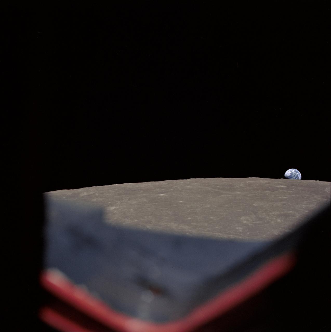
S68-55808 (23 Dec. 1968) --- This spectacular view of Earth was transmitted back from space during the second live television transmission from the Apollo 8 spacecraft on the third day of its journey toward the moon. This view is looking through a spacecraft window. At the time of this TV transmission (at 2 p.m. CST), Apollo 8 was traveling on its trans-lunar course at about 3,254 feet per second, and was some 176,533 miles from Earth.
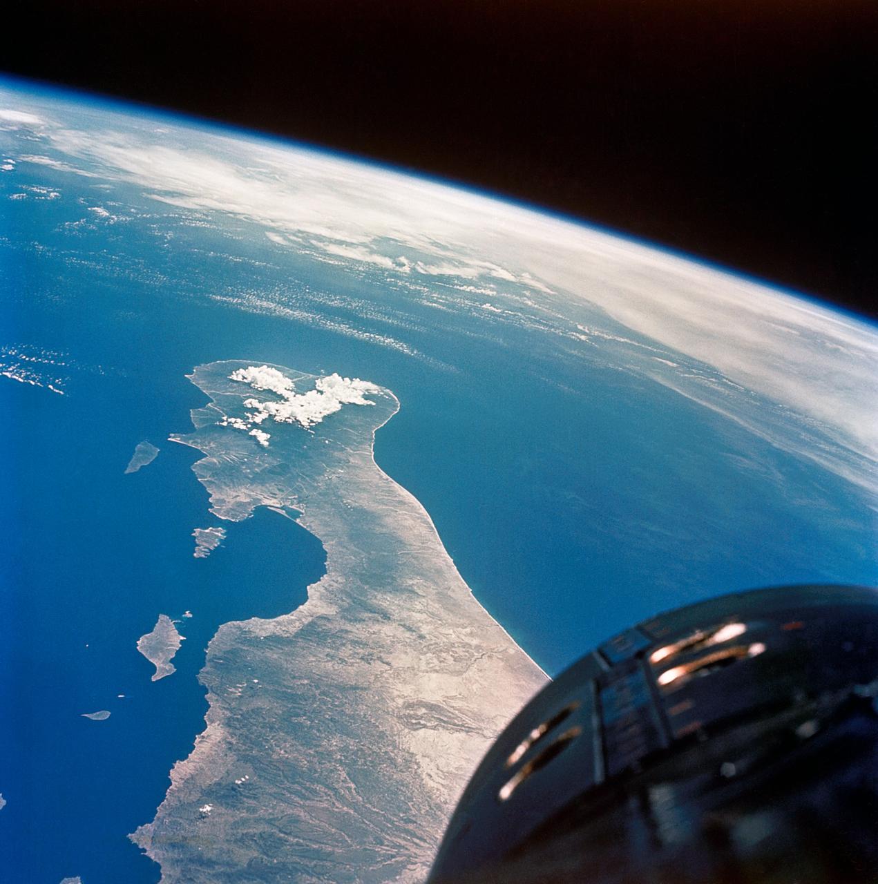
Various views of Earth taken on STS-7 for news release.
This computer generated image depicts a view of Earth as seen from the surface of the asteroid Toutatis on Nov 29th 1996. A 2.5 degree field-of-view synthetic computer camera was used for this simulation. Toutatis is visible on this date as a twelfth magnitude object in the night sky in the constellation of Virgo and could be viewed with a medium sized telescope. Toutatis currently approaches Earth once every four years and, on Nov. 29th, 1996 will be 5.2 million kilometers away (approx. 3.3 million miles). In approximately 8 years, on Sept. 29th, 2004, it will be less than 1.6 million kilometers from Earth. This is only 4 times the distance to the moon, and is the closest approach predicted for any known asteroid or comet during the next 60 years. http://photojournal.jpl.nasa.gov/catalog/PIA00515
SL3-122-2620 (July-September 1973) --- Skylab 3 Earth view of the Nile Delta, Egypt and Suez Canal. Photo credit: NASA
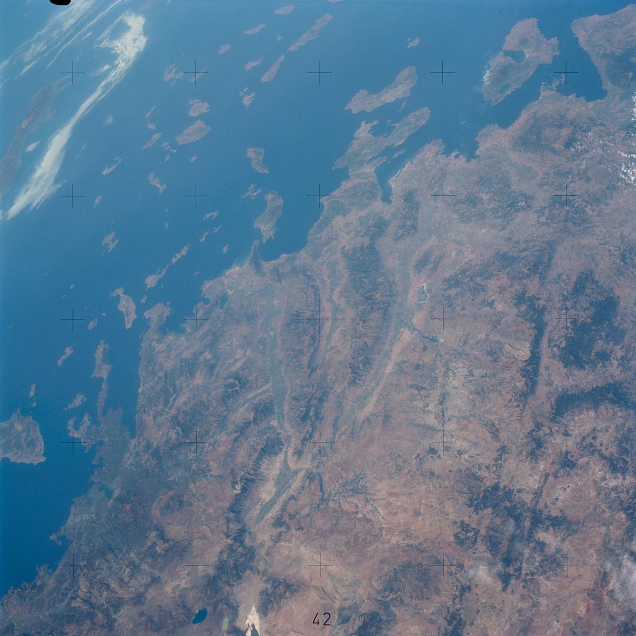
SL3-122-2558 (July-September 1973) --- Skylab 3 Earth view of southwest Turkey, Aegean Sea, Rhodes, Lesbos and Samos. Photo credit: NASA
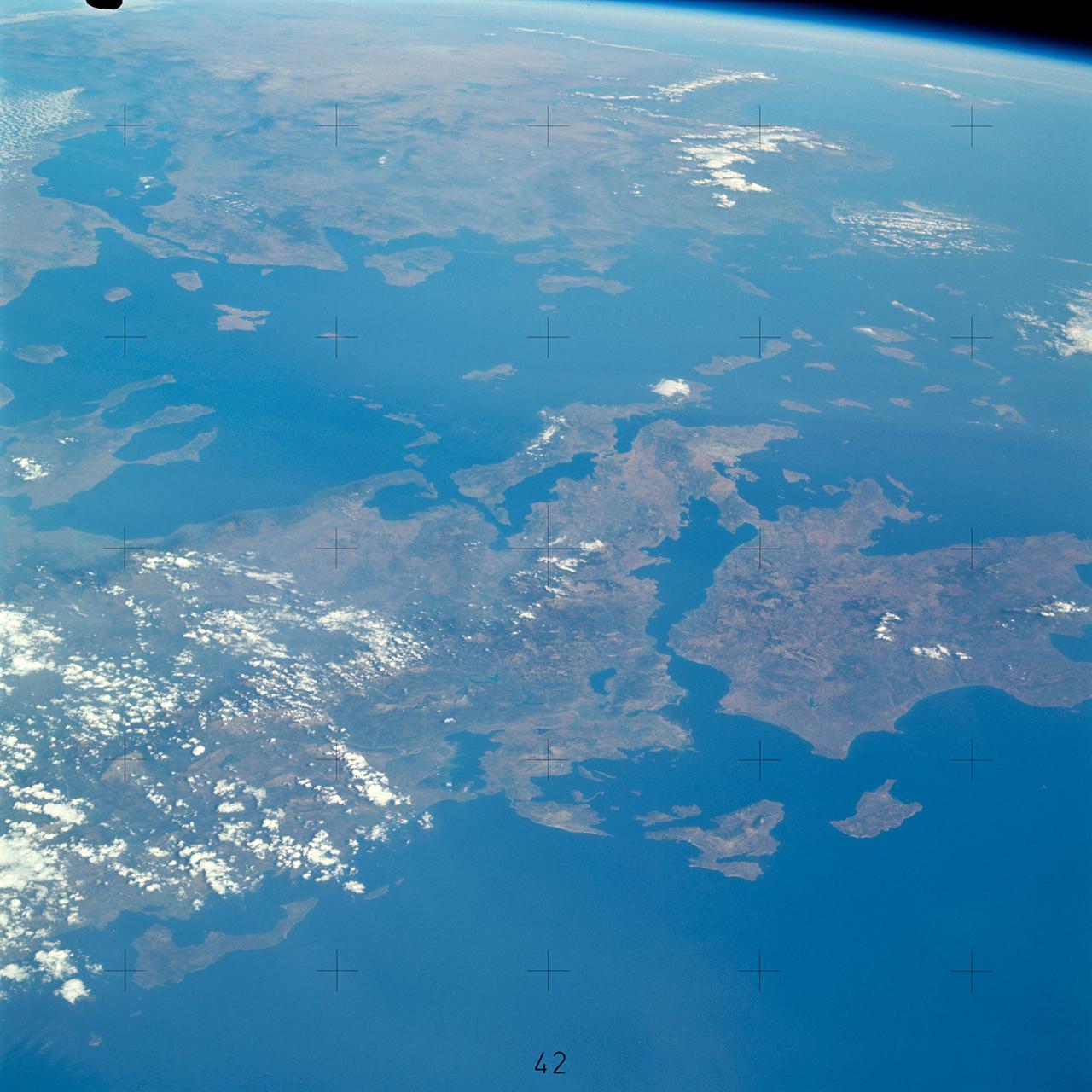
SL3-121-2367 (July-September 1973) --- Skylab 3 Earth view of Greece, Albania, Athens and Peloponnesos. Photo credit: NASA
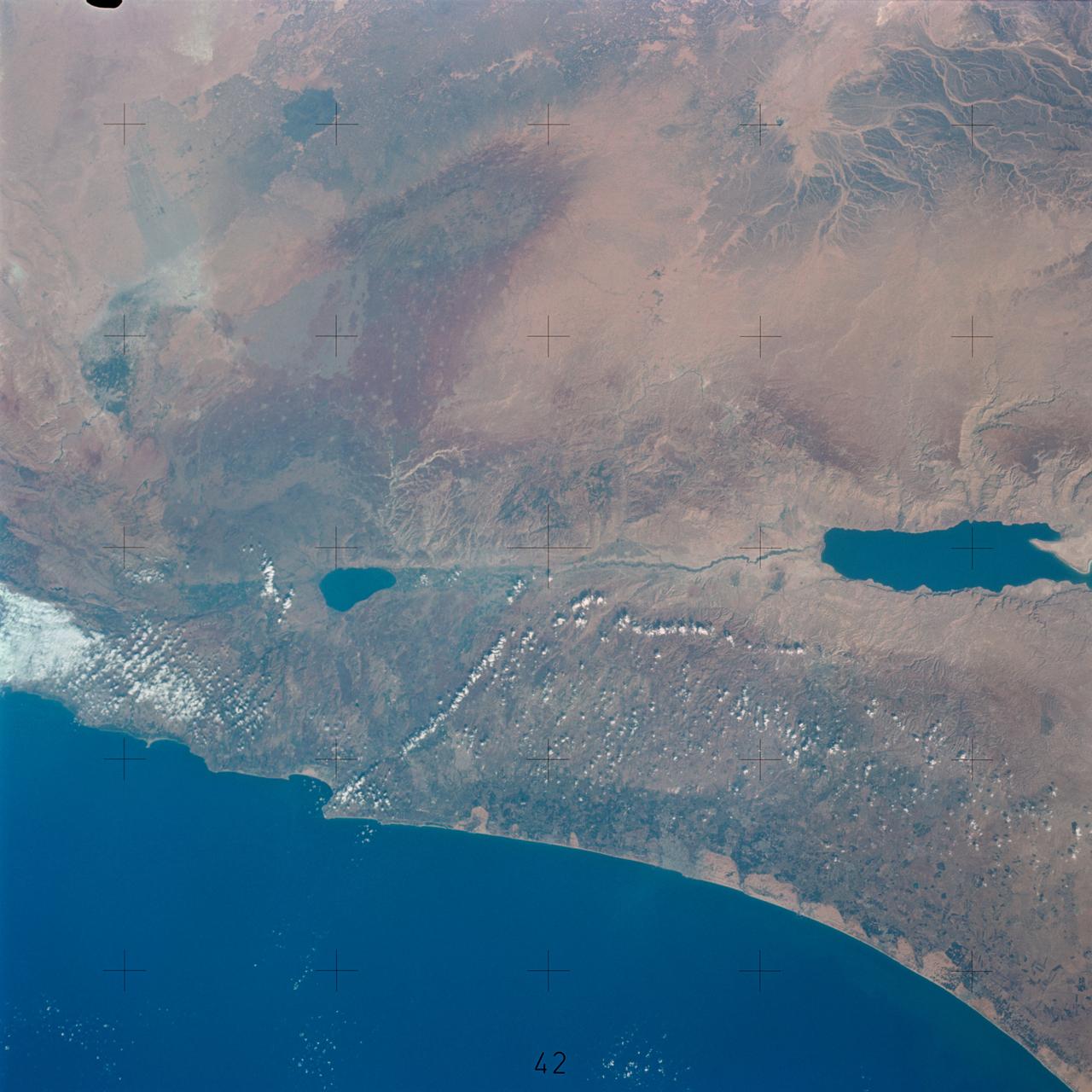
SL3-122-2621 (July-September 1973) --- Skylab 3 Earth view of the Dead Sea, Israel, Jordan River and Sea of Galilee. Photo credit: NASA

AS10-34-5010 (18 May 1969) --- This photograph of Earth was taken from the Apollo 10 spacecraft shortly after trans-lunar insertion. The counter-clockwise arrangement of the cloud formations indicates a northern hemisphere view, although insufficient amounts of land are visible for exact location.

NASA's Curiosity Mars rover used its Mast Camera, or Mastcam, to capture this view of Earth setting while Phobos, one of Mars' two moons, is rising. It's the first time an image of the two celestial bodies have been captured together from the surface of Mars. The image is a composite of five short exposures and 12 long exposures all taken on Sept. 5, 2024, the 4,295th Martian day, or sol, of Curiosity's mission. An inset in the image shows Phobos on the left and Earth on the right. From the rover's perspective, the inset area would be about half the width of a thumb held at arm's length. The image shows the sky over Texoli, a butte on lower Mount Sharp, a 3-mile-tall (5-kilometer-tall) mountain that Curiosity has been ascending since 2014. https://photojournal.jpl.nasa.gov/catalog/PIA26362
S73-34295 (June 1973) --- A vertical view of a portion of northern California reproduced from data taken from the Skylab Multispectral Scanner, experiment S192, in the Skylab space station in Earth orbit. This view is the most westerly one-third of Frame No. 001, Roll No. 518, S192, Skylab 2. Frame No. 001 extends from the Pacific coast at the Eureka area southeasterly 175 nautical miles to the Feather River drainage basin. Included in this view are Eureka, Trinidad, Klamath & Trinity Rivers and the Coastal Range mountains. This non-photographic image is a color composite of channels 2 (visible), 7, and 12 (infrared) from the Earth Resources Experiments Package (EREP) S192 scanner. The scanner techniques assist with spectral signature identification and mapping of ground truth targets in agriculture, forestry, geology, hydrology and oceanography. Photo credit: NASA
Onboard views by the STS-2 Crew of the Payload Bay with Office of Space and Terrestrial Applications (OSTA)-1 Payload, the Remote Manipulator System (RMS) and Earth views of: Korea, China and Columbia. Also available in 4x5 BW 1. REAGAN, RONALD PRESIDENT - MOCR (STS-2) JSC, HOUSTON, TX Also available in 4x5 BW, 35 CN, 35 BW
STS102-E-5114 (10 March 2001) --- An out-the-window view of the Leonardo Multi Purpose Logistics Module resting in Discovery's payload bay was recorded with a digital still camera from the International Space Station (ISS). Earth is in the background.
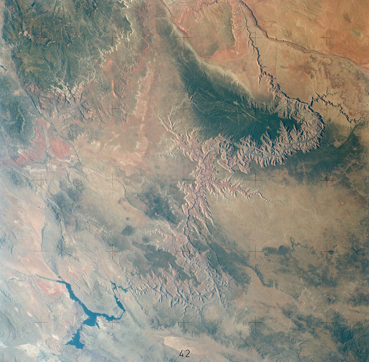
SL3-122-2581 (July-September 1973) --- Skylab 3 Earth view of the Grand Canyon, Lake Mead and Kaibab. Photo credit: NASA
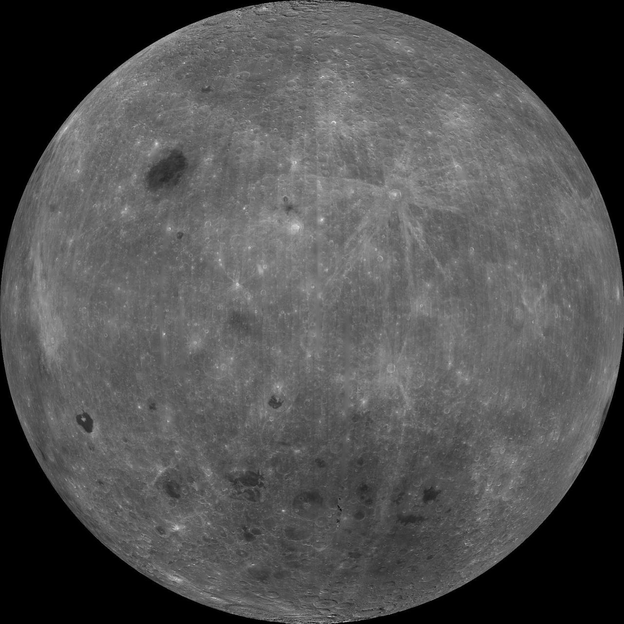
About 50,000 Clementine images were processed to produce the four orthographic views of the Moon. The images show albedo variations (normalized brightness or reflectivity) of the surface at a wavelength of 750 nm (just longward of visible red). The image projection is centered at 0 degree latitude and 180 degrees longitude. Mare Moscoviense (dark albedo feature upper left of image center) and South Pole-Aitken Basin (dark feature at bottom) represent maria regions largely absent on the lunar farside. The Clementine altimeter showed Aitken Basin to consist of a topographic rim about 2500 km in diameter, an inner shelf ranging from 400 to 600 km in width, and an irregular depressed floor about 12 km in depth. http://photojournal.jpl.nasa.gov/catalog/PIA00304
NASA GOES 13 satellite image showing earth on May 28, 2010 11:45 UTC. <b><a href="http://goes.gsfc.nasa.gov/" rel="nofollow">Credit: NOAA/NASA GOES Project</a><b> <b><a href="http://www.nasa.gov/centers/goddard/home/index.html" rel="nofollow">NASA Goddard Space Flight Center</a></b> is home to the nation's largest organization of combined scientists, engineers and technologists that build spacecraft, instruments and new technology to study the Earth, the sun, our solar system, and the universe. <b>Follow us on <a href="http://twitter.com/NASA_GoddardPix" rel="nofollow">Twitter</a></b> <b>Join us on <a href="http://www.facebook.com/pages/Greenbelt-MD/NASA-Goddard/395013845897?ref=tsd" rel="nofollow">Facebook</a></b></b></b>
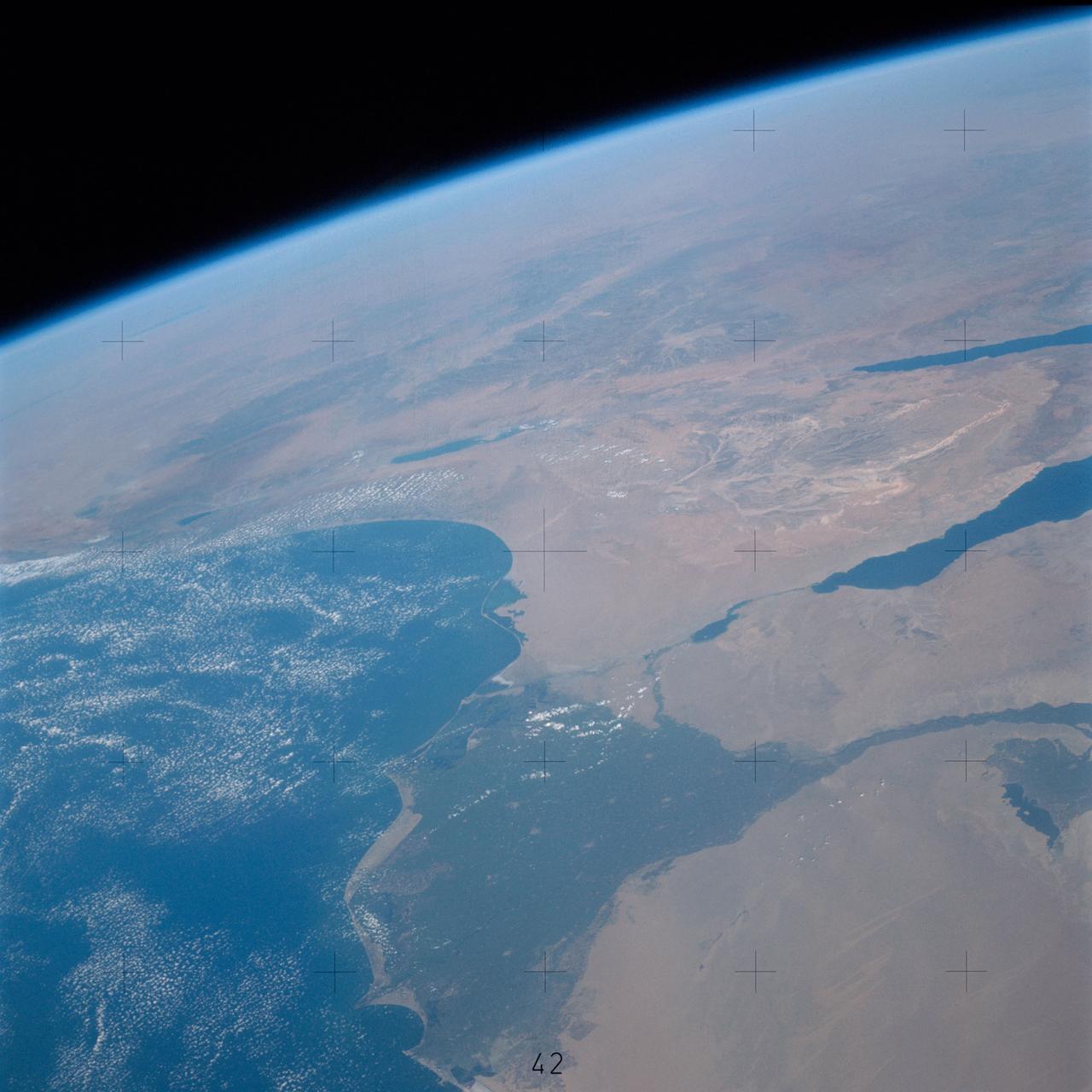
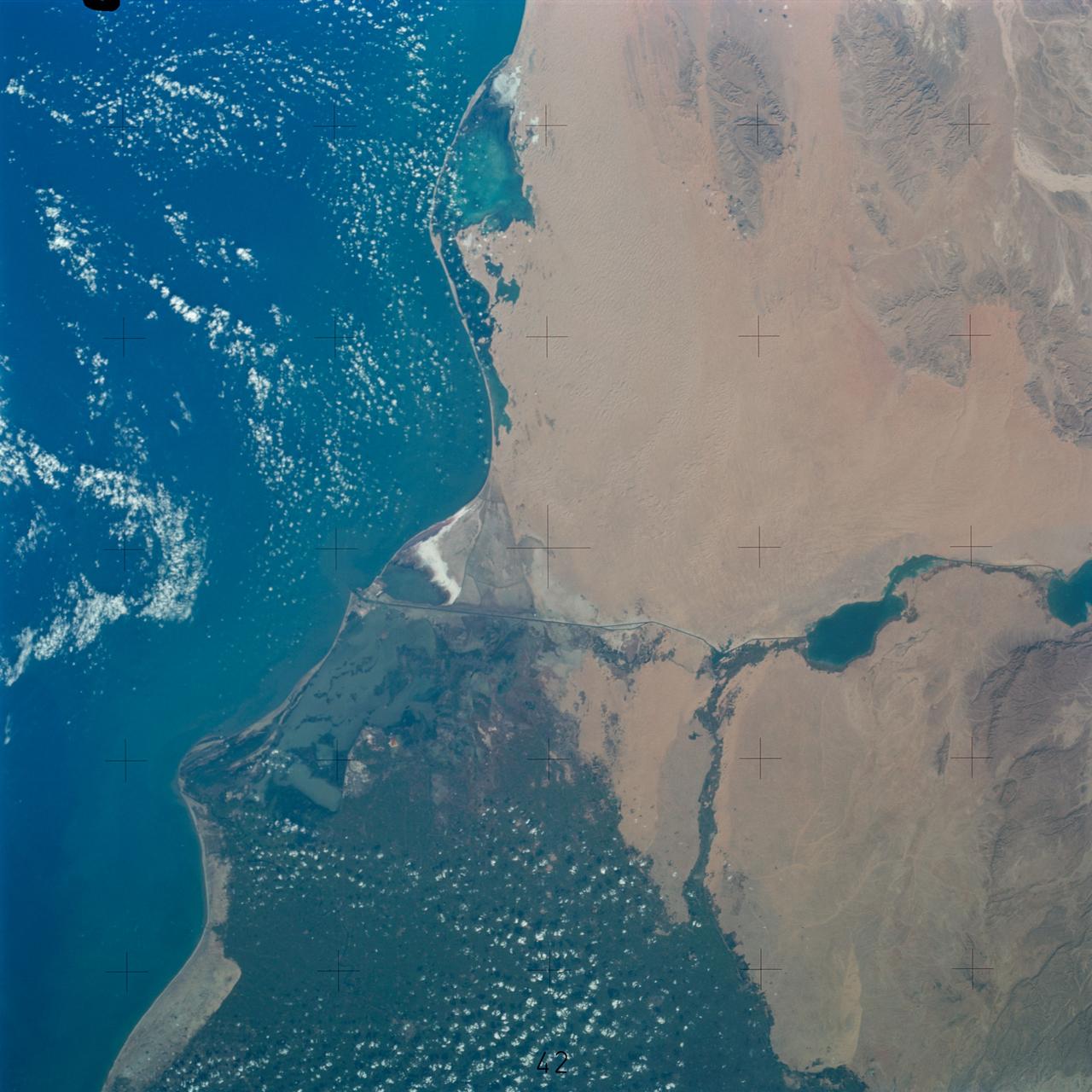
SL3-115-1917 (July-September 1973) --- Skylab 3 Earth view of the United Arab Republic (UAR), Nile Delta, Cairo, Suez Canal, Sinai and Dead Sea. Photo credit: NASA
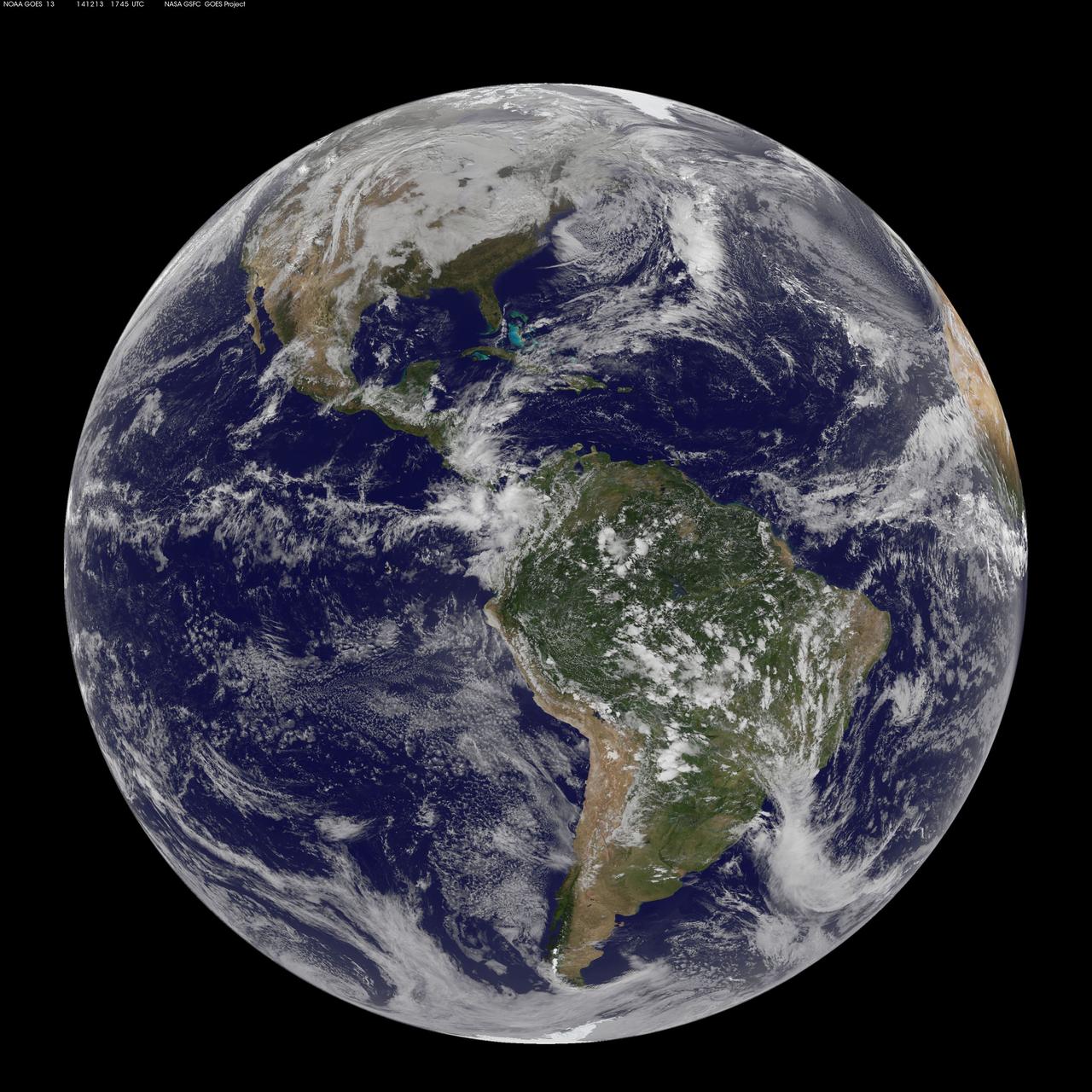
NOAA's GOES-East satellite captured this stunning view of the Americas on 12.13.14, December 13, 2014 at 17:45 UTC. The data from GOES-East was made into an image by the NASA/NOAA GOES Project at NASA's Goddard Space Flight Center in Greenbelt, Md. GOES satellites provide the kind of continuous monitoring necessary for intensive data analysis. Geostationary describes an orbit in which a satellite is always in the same position with respect to the rotating Earth. This allows GOES to hover continuously over one position on Earth's surface, appearing stationary. As a result, GOES provide a constant vigil for the atmospheric "triggers" for severe weather conditions such as tornadoes, flash floods, hail storms and hurricanes. For more information about GOES satellites, visit: <a href="http://www.goes.noaa.gov/" rel="nofollow">www.goes.noaa.gov/</a> or <a href="http://goes.gsfc.nasa.gov/" rel="nofollow">goes.gsfc.nasa.gov/</a> <b><a href="http://www.nasa.gov/audience/formedia/features/MP_Photo_Guidelines.html" rel="nofollow">NASA image use policy.</a></b> <b><a href="http://www.nasa.gov/centers/goddard/home/index.html" rel="nofollow">NASA Goddard Space Flight Center</a></b> enables NASA’s mission through four scientific endeavors: Earth Science, Heliophysics, Solar System Exploration, and Astrophysics. Goddard plays a leading role in NASA’s accomplishments by contributing compelling scientific knowledge to advance the Agency’s mission. <b>Follow us on <a href="http://twitter.com/NASAGoddardPix" rel="nofollow">Twitter</a></b> <b>Like us on <a href="http://www.facebook.com/pages/Greenbelt-MD/NASA-Goddard/395013845897?ref=tsd" rel="nofollow">Facebook</a></b> <b>Find us on <a href="http://instagrid.me/nasagoddard/?vm=grid" rel="nofollow">Instagram</a></b>
S65-18752 (23 March 1965) --- View of a cloudy part of Earth as seen from the Gemini-3 spacecraft while in orbit.

S134-E-010062 (27 May 2011) --- A portion of the International Space Station is visible in this view of a starry sky and Earth’s horizon, photographed by NASA astronaut Greg Chamitoff, STS-134 mission specialist, while space shuttle Endeavour remains docked with the station. Photo credit: NASA
AS11-36-5337 (16 July 1969) --- This view of Earth showing clouds over its surface was photographed from the Apollo 11 spacecraft during its translunar journey toward the moon. The spacecraft was already about 10,000 nautical miles from Earth when this picture was taken. Portions of the land mass of North America and Central America can be seen. Aboard Apollo 11 were astronauts Neil A. Armstrong, Michael Collins and Edwin E. Aldrin Jr.
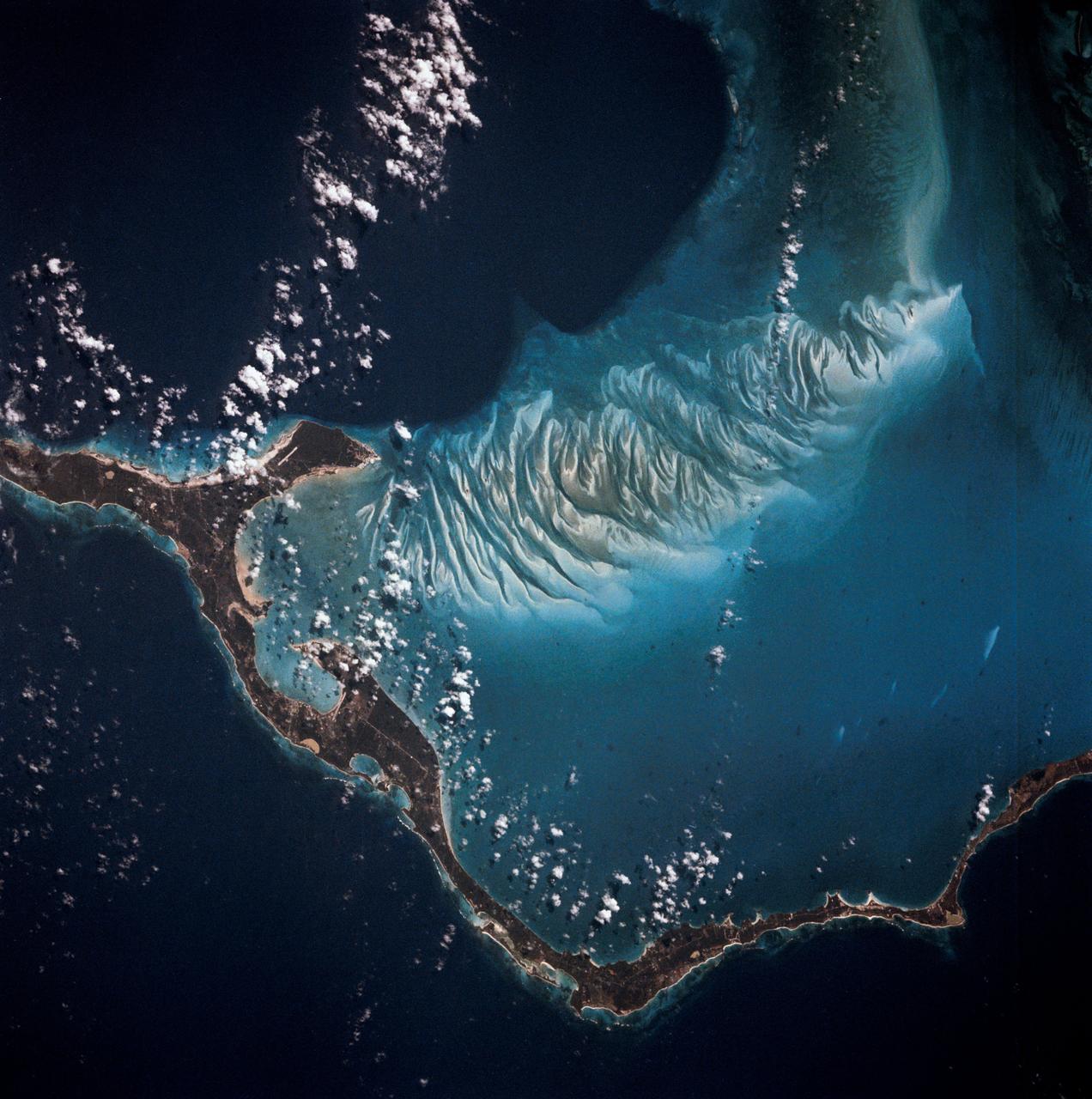
S81-30396 (12-14 April 1981) --- A vertical view of Eleuthera Island in the Bahamas and part of the great Bahama Bank, as photographed with a 70mm handheld camera from the space shuttle Columbia in Earth orbit. The light blue of the Bahama Bank contrasts sharply with the darker blue of the deep ocean waters. Astronauts John W. Young, commander, and Robert L. Crippen, pilot, took a series of Earth photos from inside the flight deck of the Columbia, which has windows on its top side, convenient for shooting photographs as the spacecraft flew ?upside down? above Earth. The mission frame ID number is STS001-12-322. Photo credit: NASA
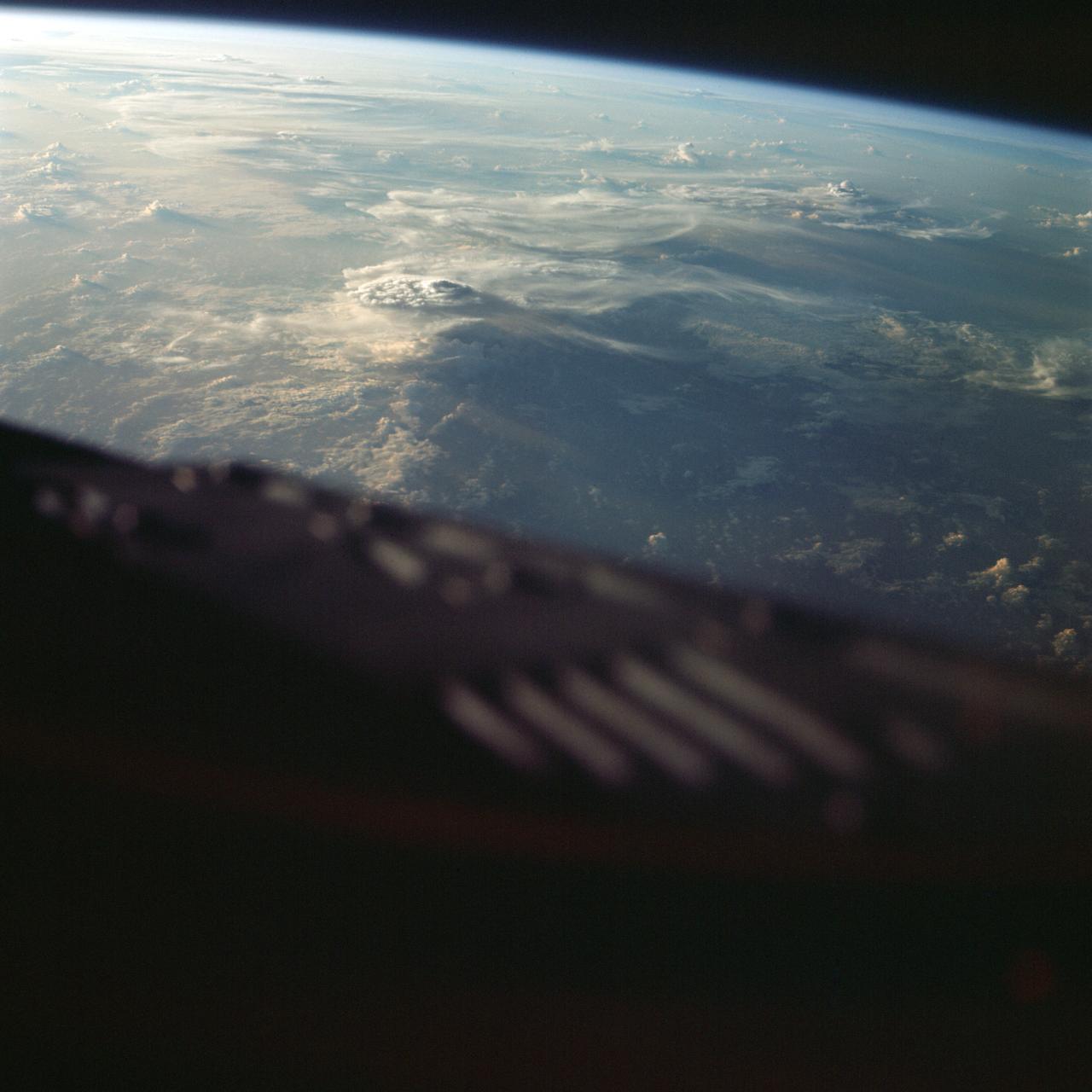
Discovery's, Orbiter Vehicle (OV) 103's, vertical stabilizer and orbital maneuvering system (OMS) pods are backdropped against the contrasted blackness of space illuminated by a colorful Earth / sunrise panorama. View was taken through the aft flight deck viewing windows during STS-26.
SL3-121-2410 (July-September 1973) --- Skylab 3 Earth view of Washington, British Columbia, Vancouver Island and Puget Sound. Photo credit: NASA

SL3-115-1924 (July-September 1973) --- Skylab 3 Earth view of Israel, Jordan, Lebanon, Syria, Iraq and the Dead Sea. Photo credit: NASA
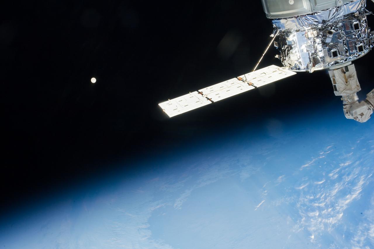
Distant view of the Moon over Earth limb taken by the Expedition 37 crew aboard the International Space Station (ISS). An ISS solar array is also visible.
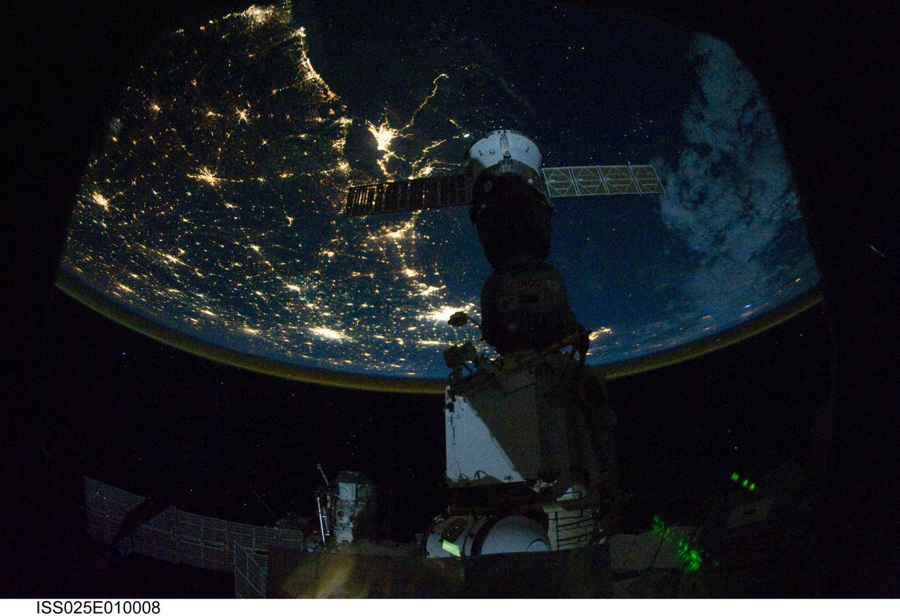
ISS025-E-010008 (29 Oct. 2010) --- From 220 miles above Earth, one of the Expedition 25 crew members onboard the International Space Station shot this night time image of the northern Gulf coast. Mobile Bay and the city of Mobile (top left, beneath one of the solar panels of a docked Russian Soyuz spacecraft), New Orleans and Houston are visible as the view ?moves? southeastward. The Interstate Highway 20 cities of Jackson, Shreveport, Dallas and Fort Worth are also visible further inland. The view extends northward (left) to Little Rock and Oklahoma City.
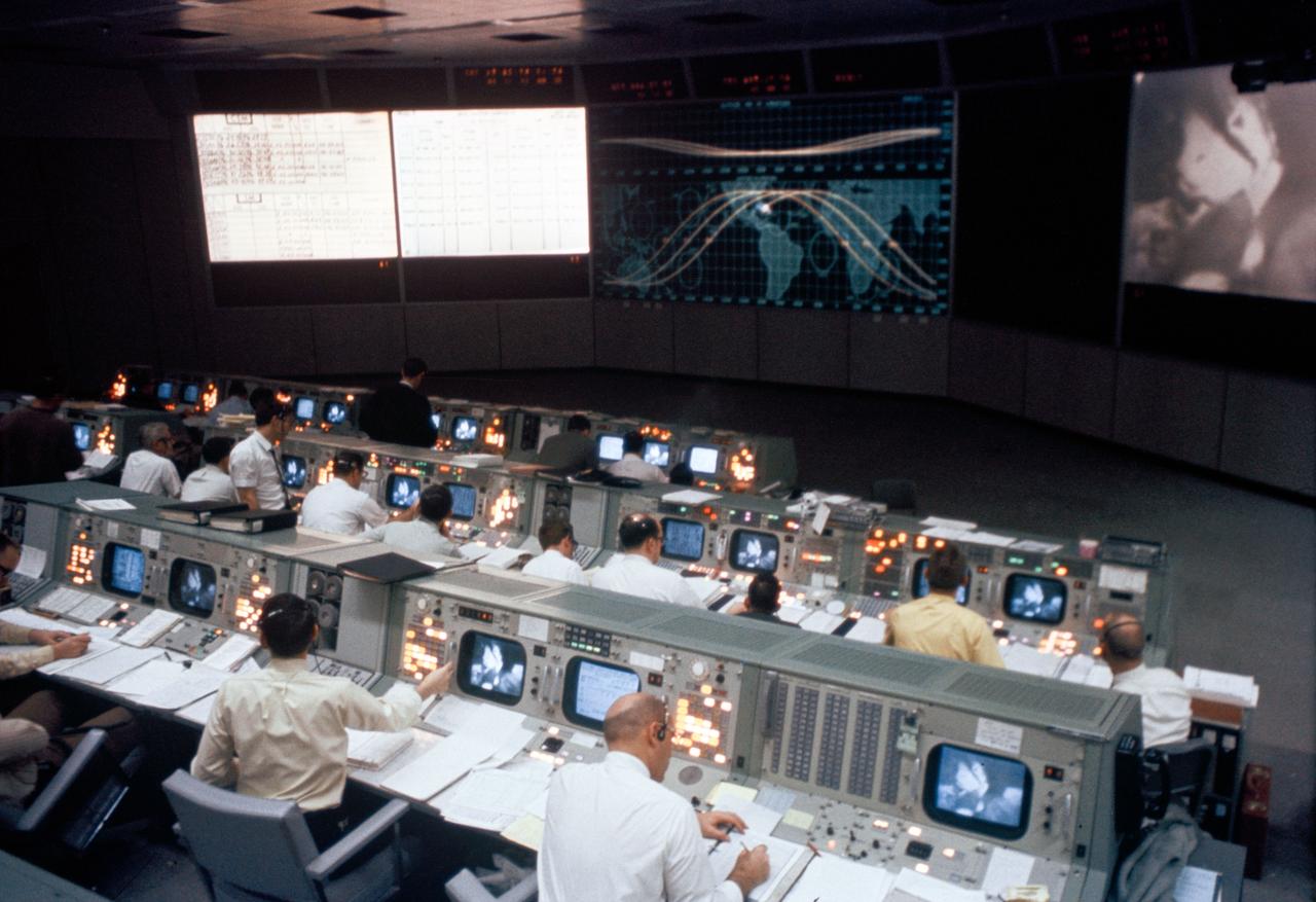
S69-26301 (March 1969) --- Overall view of the Mission Operations Control Room in the Mission Control Center, Building 30, during the Apollo 9 Earth-orbital mission. When this photograph was taken a live television transmission was being received from Apollo 9 as it orbited Earth.

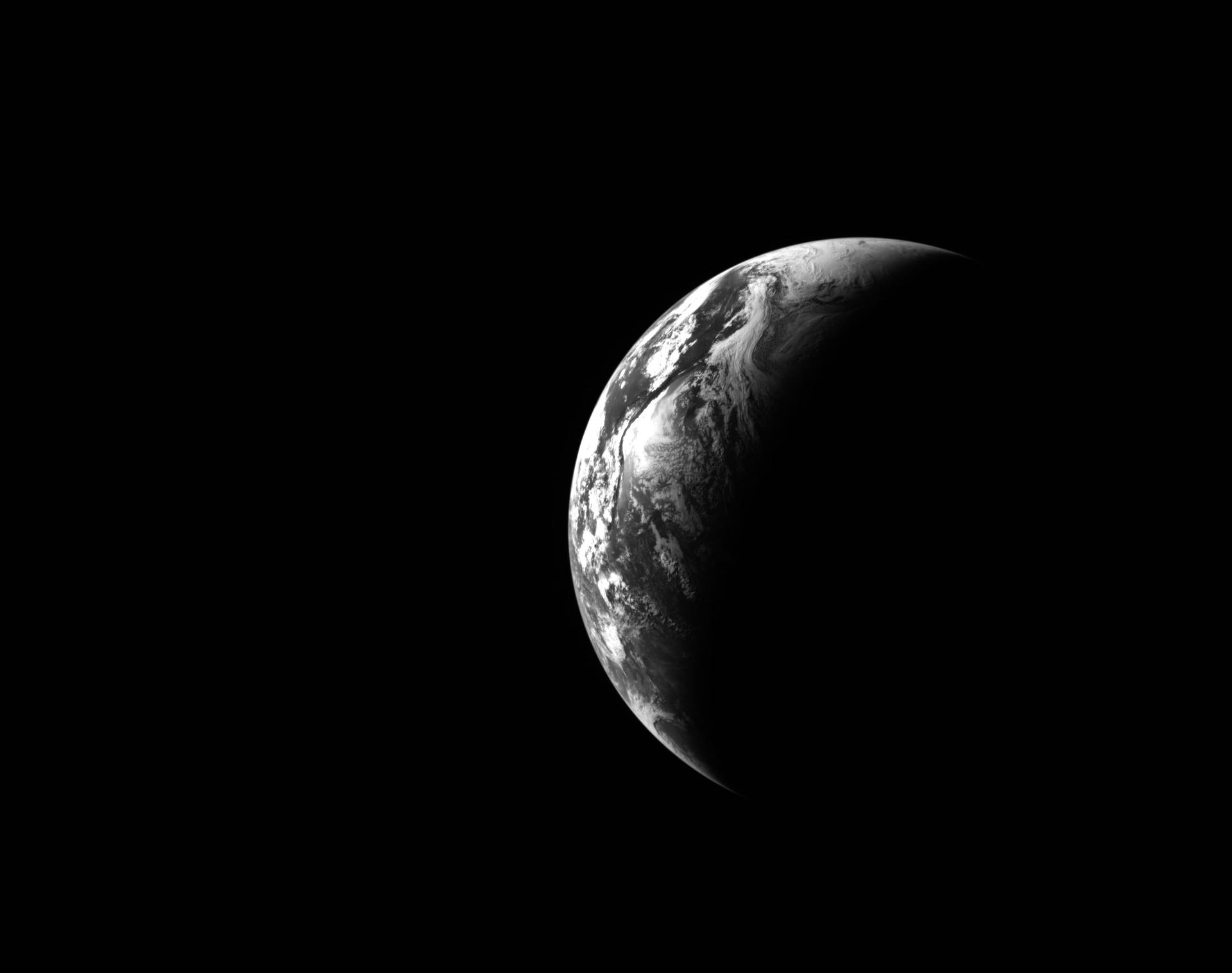
This view of the Earth shows a wonderfully unique but physically impossible view of the southern hemisphere and Antarctica. While a spacecraft could find itself directly over the Earth pole, roughly half of the image should be in darkness!

AS15-91-12343 (26 July 1971) --- This view of Earth was photographed by the Apollo 15 crewmen as they sped toward the fourth lunar landing. The spacecraft was between 25,000 and 30,000 nautical miles from Earth when this photo was made. The United States (note Florida), Central America and part of Canada can be seen at the left side of the picture, with South America at lower center. Spain and the northwest part of Africa can be seen at right. The Bahamas Banks, unique geological feature, can be seen (different shade of blue) east of Florida. Also note large North Atlantic storm front moving over Greenland in upper center.
S65-45763 (21-29 Aug. 1965) --- View of the lower tip of Baja, California and Bahia de la Paz taken from the Gemini-5 spacecraft in orbit over Earth.
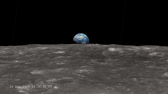
<b>Join NASA's Google+ Hangout on Friday, December 20th 2:00 - 3:00 PM (EST) at <a href="http://go.nasa.gov/18S2TbC" rel="nofollow">go.nasa.gov/18S2TbC</a> </b> It was 45 years ago, on December 24, 1968 when Apollo 8 astronauts captured 'Earthrise' – the first color photograph of Earth taken by a person in lunar orbit. NASA announces a new simulation of the events leading to the creation of 'Earthrise,' one of the iconic photographs of the 20th Century – Earth seen from the moon captured by the crew of Apollo 8. This new simulation allows anyone to virtually ride with the astronauts and experience the awe they felt at the vista in front of them. Apollo 8 Commander Frank Borman and crew members William A. Anders and James A. Lovell photographed the stunning scene as their spacecraft orbited the moon on December 24, 1968. The new computer simulation was created using data from NASA's Lunar Reconnaissance Orbiter, or LRO, spacecraft and includes details not seen in the previous visualization released last year. Participants in this Hangout include: * John Keller, project scientist for the Lunar Reconnaissance Orbiter project * Ernie Wright, project lead with the Scientific Visualization Studio at NASA Goddard Space Flight Center * Andrew Chaikin, space historian, author of the book A Man on the Moon "This will also be the first time we've released a video that's synchronized with the onboard audio recording of the astronauts,", says Ernie Wright. "The new visualization tells us not only what time the photos were taken, but also exactly which way the spacecraft was pointing and therefore which window each photo was taken from." Earthrise is the cover photo of TIME's Great Images of the 20th Century and is among photos on the cover of LIFE's 100 Photographs That Changed the World. <b><a href="http://www.nasa.gov/audience/formedia/features/MP_Photo_Guidelines.html" rel="nofollow">NASA image use policy.</a></b> <b><a href="http://www.nasa.gov/centers/goddard/home/index.html" rel="nofollow">NASA Goddard Space Flight Center</a></b> enables NASA’s mission through four scientific endeavors: Earth Science, Heliophysics, Solar System Exploration, and Astrophysics. Goddard plays a leading role in NASA’s accomplishments by contributing compelling scientific knowledge to advance the Agency’s mission. <b>Follow us on <a href="http://twitter.com/NASA_GoddardPix" rel="nofollow">Twitter</a></b> <b>Like us on <a href="http://www.facebook.com/pages/Greenbelt-MD/NASA-Goddard/395013845897?ref=tsd" rel="nofollow">Facebook</a></b> <b>Find us on <a href="http://instagram.com/nasagoddard?vm=grid" rel="nofollow">Instagram</a></b>
AS10-34-5013 (18 May 1969) --- A view of Earth from 36,000 nautical miles away as photographed from the Apollo 10 spacecraft during its trans-lunar journey toward the moon. While the Yucatan Peninsula is obscured by clouds, nearly all of Mexico north of the Isthmus of Tehuantepec can be clearly delineated. The Gulf of California and Baja California and the San Joaquin Valley can be easily identified. Also, the delta of the Rio Grande River and the Texas coast are visible. Note the color differences (greens - east, browns - west) along the 100 degrees meridian. The crew members on Apollo 10 are astronauts Thomas P. Stafford, commander; John W. Young, command module pilot; and Eugene E. Cernan, lunar module pilot. Astronaut Young remained in lunar orbit, in the Command and Service Modules (CSM) "Charlie Brown", while astronauts Stafford and Cernan descended to within nine miles of the lunar surface, in the Lunar Module (LM) "Snoopy".
Eight days after its encounter with the Earth, the Galileo spacecraft was able to look back and capture this remarkable view of the Moon in orbit about the Earth, taken from a distance of about 6.2 million kilometers (3.9 million miles). The picture was constructed from images taken through the violet, red, and 1.0-micron infrared filters. The Moon is in the foreground, moving from left to right. The brightly-colored Earth contrasts strongly with the Moon, which reflects only about one-third as much sunlight as the Earth. Contrast and color have been computer-enhanced for both objects to improve visibility. Antarctica is visible through clouds (bottom). The Moon's far side is seen; the shadowy indentation in the dawn terminator is the south-Pole/Aitken Basin, one of the largest and oldest lunar impact features. Alternate Jet Propulsion Laboratory (JPL) number is P-41508. View appears in the Space News Roundup v32 n1 p1, 01-11-93.
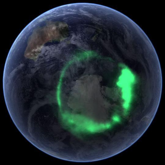
NASA file image acquired September 11, 2005 <b>To view a video of this event go here: <a href="http://www.flickr.com/photos/gsfc/6257608714">www.flickr.com/photos/gsfc/6257608714</a></b> From space, the aurora is a crown of light that circles each of Earth’s poles. The IMAGE satellite captured this view of the aurora australis (southern lights) on September 11, 2005, four days after a record-setting solar flare sent plasma—an ionized gas of protons and electrons—flying towards the Earth. The ring of light that the solar storm generated over Antarctica glows green in the ultraviolet part of the spectrum, shown in this image. The IMAGE observations of the aurora are overlaid onto NASA’s satellite-based Blue Marble image. From the Earth’s surface, the ring would appear as a curtain of light shimmering across the night sky. Like all solar storms, the September storm distorted the shape of the magnetic field that surrounds the Earth. Without buffeting from the solar wind (charged particles like protons and electrons that are ejected from the Sun), the Earth’s magnetic field would look something like a plump doughnut, with the North and South poles forming the slender hole in the center. In reality, the nearly constant solar winds flatten the space side of the “doughnut” into a long tail. The amount of distortion changes when solar storms, such as the flare on September 7, send stronger winds towards the Earth. Changes to the magnetic field release fast-moving particles, which flow with charged particles from the Sun towards the center of the “doughnut” at the Earth’s poles. As the particles sink into the atmosphere, they collide with oxygen and nitrogen, lighting the sky with Nature’s version of neon lights, the aurora. Though scientists knew that the aurora were caused by charged particles from the Sun and their interaction with the Earth’s magnetic field, they had no way to measure the interaction until NASA launched the Imager for Magnetopause-to-Aurora Global Exploration (IMAGE) satellite in 2000. The satellite’s mission was to collect data that would allow scientists to study the structure and dynamics of the Earth’s magnetic field for the first time. Designed to operate for two years, IMAGE sent its last data to Earth in December 2005 after a highly successful five-year mission. Since 2000, IMAGE has provided insight into how the Earth’s powerful magnetic field protects the planet from solar winds. Without the shield the magnetic field provides, the upper atmosphere would evaporate into space under the influence of solar winds. IMAGE has shown scientists what sort of changes the magnetic field undertakes as it diverts solar winds from the Earth. For a summary of the discoveries that IMAGE has made possible, see IMAGE Discovers. Instrument: IMAGE Credit: <a href="http://svs.gsfc.nasa.gov/index.html" rel="nofollow">NASA/Goddard Space Flight Center Scientific Visualization Studio</a> <b><a href="http://www.nasa.gov/audience/formedia/features/MP_Photo_Guidelines.html" rel="nofollow">NASA image use policy.</a></b> <b><a href="http://www.nasa.gov/centers/goddard/home/index.html" rel="nofollow">NASA Goddard Space Flight Center</a></b> enables NASA’s mission through four scientific endeavors: Earth Science, Heliophysics, Solar System Exploration, and Astrophysics. Goddard plays a leading role in NASA’s accomplishments by contributing compelling scientific knowledge to advance the Agency’s mission. <b>Follow us on <a href="http://twitter.com/NASAGoddardPix" rel="nofollow">Twitter</a></b> <b>Like us on <a href="http://www.facebook.com/pages/Greenbelt-MD/NASA-Goddard/395013845897?ref=tsd" rel="nofollow">Facebook</a></b> <b>Find us on <a href="http://instagrid.me/nasagoddard/?vm=grid" rel="nofollow">Instagram</a></b>
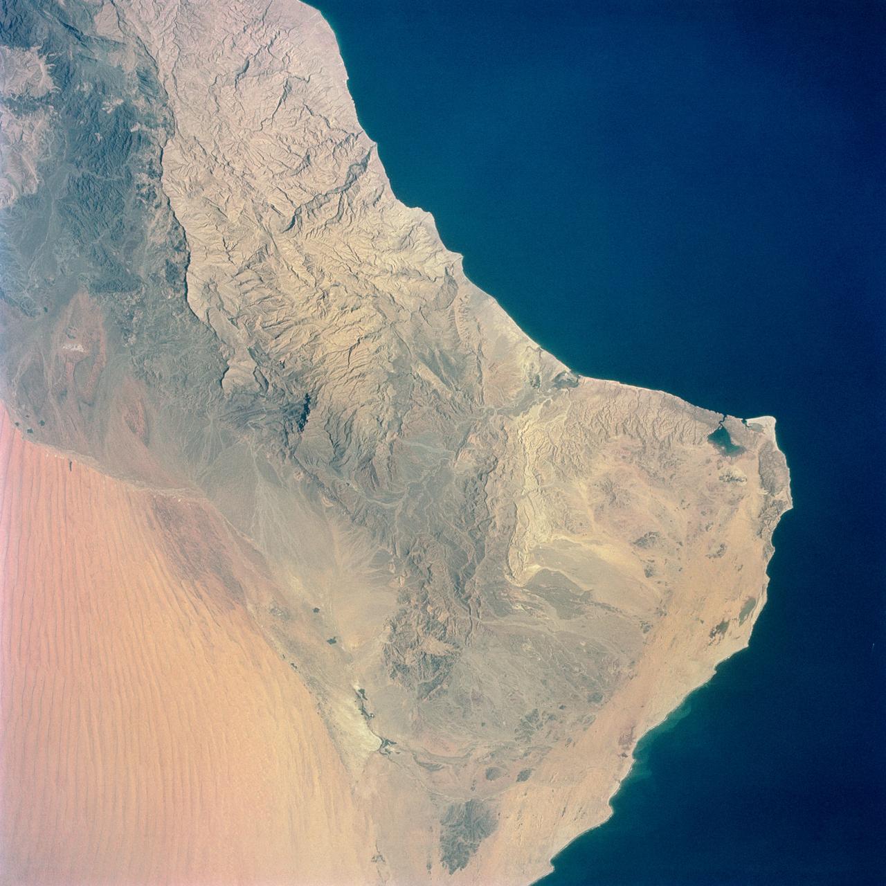
S65-34661 (3-7 June 1965) --- Among the photographs of Earth's terrain taken from the Gemini-4 spacecraft during its orbital mission was this view of the southeastern tip of the Arabian Peninsula with the Gulf of Oman at upper right. Seif dunes (sand) at lower left. This picture was taken with a modified 70mm Hasselblad camera, using Eastman color film, ASA 64 at a setting of 250th of a second at f/11. Dr. Paul Lowman Jr., NASA geologist, was in charge of the Synoptic Terrain Photography.
AS12-50-7362 (14 Nov. 1969) --- A view of one-third of Earth, with Australia on the horizon, as photographed by the three-man crew of Apollo 12. The Command and Service Modules, mated to the Lunar Module (yet to be removed and transpositioned for landing) were en route to the moon for man's second mission there. Onboard the spacecraft were astronauts Charles Conrad Jr., Richard F. Gordon Jr. and Alan L. Bean. Photo credit: NASA
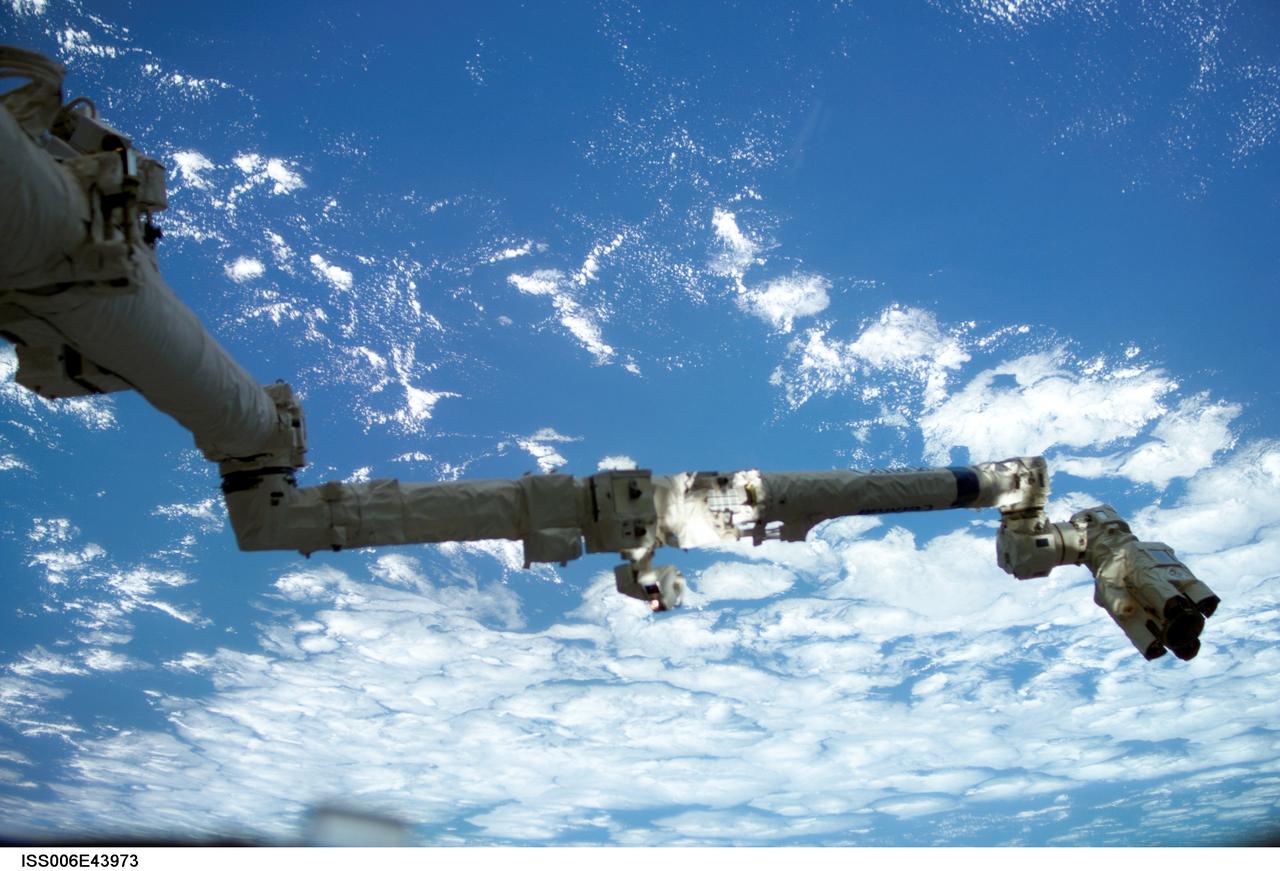
ISS006-E-43973 (6 April 2003) --- Backdropped against a blue and white Earth, the Space Station Remote Manipulator System (SSRMS) or Canadarm2 is pictured in this digital still camera’s view taken from the International Space Station (ISS).
AS10-27-3890 (18-26 May 1969) --- A view of Earth rising above the lunar horizon photographed from the Apollo 10 Lunar Module, looking west in the direction of travel. The Lunar Module at the time the picture was taken was located above the lunar farside highlands at approximately 105 degrees east longitude.

This view of the twilight sky and Martian horizon taken by NASA Curiosity Mars rover includes Earth as the brightest point of light in the night sky. Earth is a little left of center in the image, and our moon is just below Earth.
STS-32 crew took this view of the moon setting over the Earth's limb. Near the center is a semi-vortex in the clouds - a storm system in the early stages of formation. The moon's image is distorted due to refraction through the Earth's atmosphere. The near side of the moon is visible showing the vast area of the moon's western seas (Mare Occidental), Apollo landing sites: Apollo 14 at Fra Mauro and Apollo 16 at Central Highlands near Descartes.

During its flight, NASA’s Galileo spacecraft returned images of the Earth and Moon. Separate images of the Earth and Moon were combined to generate this view. http://photojournal.jpl.nasa.gov/catalog/PIA00342
About 50,000 Clementine images were processed to produce the four orthographic views of the Moon. The images show albedo variations (normalized brightness or reflectivity) of the surface at a wavelength of 750 nm (just longward of visible red). The image projection is centered at 0 degree latitude and 180 degrees longitude. Mare Moscoviense (dark albedo feature upper left of image center) and South Pole-Aitken Basin (dark feature at bottom) represent maria regions largely absent on the lunar farside. The Clementine altimeter showed Aitken Basin to consist of a topographic rim about 2500 km in diameter, an inner shelf ranging from 400 to 600 km in width, and an irregular depressed floor about 12 km in depth. http://photojournal.jpl.nasa.gov/catalog/PIA00303
About 50,000 Clementine images were processed to produce the four orthographic views of the Moon. The images show albedo variations (normalized brightness or reflectivity) of the surface at a wavelength of 750 nm (just longward of visible red). The image projection is centered at 0 degree latitude and 180 degrees longitude. Mare Moscoviense (dark albedo feature upper left of image center) and South Pole-Aitken Basin (dark feature at bottom) represent maria regions largely absent on the lunar farside. The Clementine altimeter showed Aitken Basin to consist of a topographic rim about 2500 km in diameter, an inner shelf ranging from 400 to 600 km in width, and an irregular depressed floor about 12 km in depth. http://photojournal.jpl.nasa.gov/catalog/PIA00304
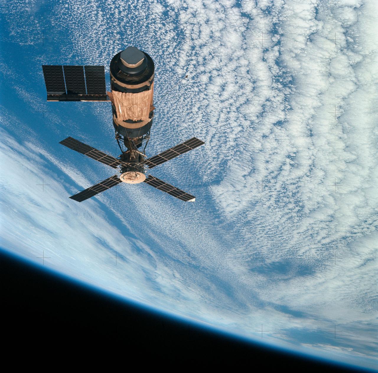
SL4-143-4707 (8 Feb. 1974) --- An overhead view of the Skylab space station cluster in Earth orbit as photographed from the Skylab 4 Command and Service Modules (CSM) during the final fly-around by the CSM before returning home. The space station is contrasted against a cloud-covered Earth. Note the solar shield which was deployed by the second crew of Skylab and from which a micrometeoroid shield has been missing since the cluster was launched on May 14, 1973. The OWS solar panel on the left side was also lost on workshop launch day. Photo credit: NASA
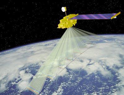
This artist concept is of NASA MISR spacecraft which views the sunlit Earth simultaneously at nine widely spaced angles.

This trio of NASA Junocam views of Earth was taken during Juno close flyby on October 9, 2013.
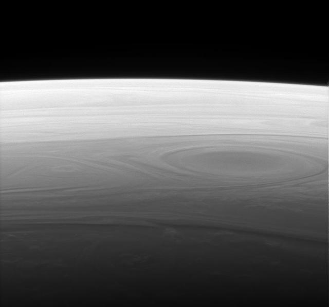
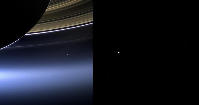
The Cassini spacecraft returns a grand and unique vista of Saturn horizon, reminiscent of the views of our own planet from Earth orbit
These images show views of Earth and the moon from NASA Cassini left and MESSENGER spacecraft right from July 19, 2013.
AS16-118-18885 (16 April 1972) --- A good view of Earth photographed about one and one-half hours after trans-lunar injection on April 16, 1972. Although there is much cloud cover, the United States in large part, most of Mexico and some parts of Central America are clearly visible. Note Lake Michigan and Lake Superior and the Bahama Banks (see different shade of blue below Florida). Just beginning man's fifth lunar landing mission were astronauts John W. Young, commander; Thomas K. Mattingly, II, command module pilot and Charles M. Duke Jr., lunar module pilot. While astronauts Young and Duke descended in the Lunar Module (LM) "Orion" to explore the Descartes highlands region of the moon, astronaut Mattingly remained with the Command and Service Modules (CSM) "Casper" in lunar orbit.
AS16-118-18880 (16 April 1972) --- A good view of Earth photographed about one hour after trans-lunar injection on April 16, 1972. Although there is much cloud cover, the United States in large part, most of Mexico and some of Central America are clearly visible. Note the Great Lakes (Michigan and Superior) and the Bahama Banks (note different shade of blue below Florida). While astronauts John W. Young, commander, and Charles M. Duke Jr., lunar module pilot, descended in the Lunar Module (LM) "Orion" to explore the Descartes highlands region of the moon, astronaut Thomas K. (Ken) Mattingly II, command module pilot, remained with the Command and Service Modules (CSM) "Casper" in lunar orbit.
AS16-118-18873 (16 April 1972) --- A good view of Earth photographed shortly after trans-lunar injection of April 16, 1972. Although there is much cloud cover (over Canada and the oceans), the United States in large part, most of Mexico and some parts of Central America are clearly visible. Note Lake Michigan and Lake Superior, also note the Bahama Banks at upper right part of the sphere. A large part of the Rocky Mountain Range is also visible. Just beginning man's fifth lunar landing mission were astronauts John W. Young, commander; Thomas K. Mattingly II, command module pilot; and Charles M. Duke Jr., lunar module pilot. While astronauts Young and Duke descended in the Lunar Module (LM) to explore the moon, astronaut Mattingly remained with the Command and Service Modules (CSM) in lunar orbit.
STS098-713A-075 (16 February 2001) --- Backdropped by Earth dotted with clouds, this close-up view of the International Space Station (ISS) with the newly-attached Destiny laboratory, was photographed by one of the astronauts onboard Atlantis. As the primary payload for the STS-98 mission, Destiny is the centerpiece of the ISS, where unprecedented science experiments will be performed in space. The shuttle and the station parted company at 8:06 a.m. (CST), Feb. 16, as Polansky flew the shuttle halfway around the outpost and its new Destiny laboratory before moving off.

41G-11-027 (14 Oct. 1984) --- Kathryn D. Sullivan, 41-G mission specialist, uses a pair of binoculars to do some magnified viewing through the forward cabin windows of the Earth-orbiting space shuttle Challenger. The 35mm frame was part of the first photographic release from the eight-day 41-G mission on Oct. 14, 1984. Photo credit: NASA

AS11-36-5299 (16 July 1969) --- This view of Earth showing clouds over water was photographed from the Apollo 11 spacecraft following translunar injection. While astronauts Neil A. Armstrong, commander, and Edwin E. Aldrin Jr., lunar module pilot, descended in the Lunar Module (LM) "Eagle" to explore the Sea of Tranquility region of the moon, astronaut Michael Collins, command module pilot, remained with the Command and Service Modules (CSM) "Columbia" in lunar orbit.
AS8-14-2392 (21-27 Dec. 1968) --- High-oblique view of the moon's surface showing Earth rising above the lunar horizon, looking west-southwest, as photographed from the Apollo 8 spacecraft as it orbited the moon. The center of the picture is located at about 105 degrees east longitude and 13 degrees south latitude. The lunar surface probably has less pronounced color than indicated by this print.
S62-06014 (20 Feb. 1962) --- View of Earth taken by astronaut John H. Glenn Jr. during his Mercury Atlas 6 (MA-6) spaceflight. Photo credit: NASA
S88-50997 (20 Feb. 1962) --- View of Earth taken by astronaut John H. Glenn Jr. during his Mercury Atlas 6 (MA-6) spaceflight. Photo credit: NASA
S62-06018 (20 Feb. 1962) --- View of Earth taken by astronaut John H. Glenn Jr. during his Mercury Atlas 6 (MA-6) spaceflight. Photo credit: NASA

S62-03270 (24 May 1962) --- Earth and sky views taken with hand-held camera by astronaut M. Scott Carpenter during Mercury-Atlas 7 (MA-7) mission. Photo credit: NASA
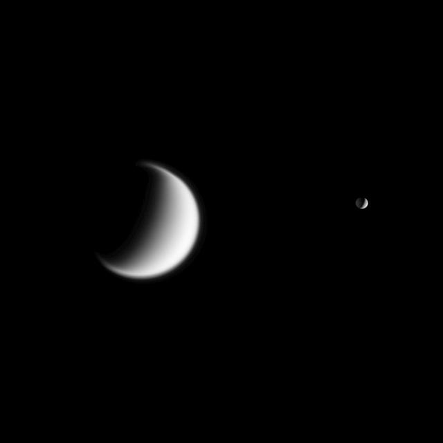
Titan, Saturn largest moon and Mimas in the foreground are seen together in this view from Cassini. Titan gravity is weaker than Earth, so the moon atmosphere is quite extended -- a quality hinted at in this view
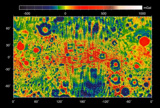
This map shows the gravity field of the moon from the Lunar Prospector mission. The viewing perspective, known as a Mercator projection, shows the far side of the moon in the center and the nearside as viewed from Earth at either side.
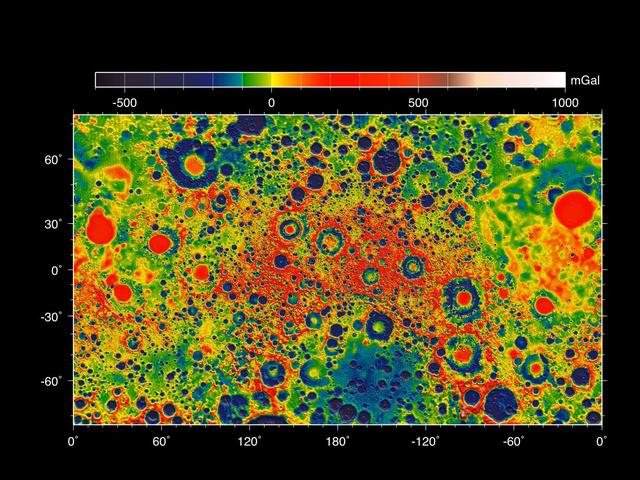
This map shows the gravity field of the moon as measured by NASA GRAIL mission. The viewing perspective, known as a Mercator projection, shows the far side of the moon in the center and the nearside as viewed from Earth at either side.
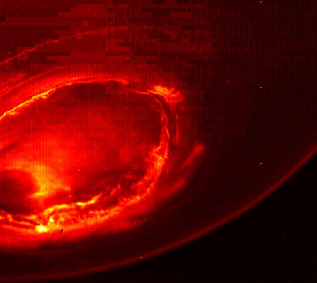
This infrared image gives an unprecedented view of the southern aurora of Jupiter, as captured by NASA's Juno spacecraft on August 27, 2016. The planet's southern aurora can hardly be seen from Earth due to our home planet's position in respect to Jupiter's south pole. Juno's unique polar orbit provides the first opportunity to observe this region of the gas-giant planet in detail. Juno's Jovian Infrared Auroral Mapper (JIRAM) camera acquired the view at wavelengths ranging from 3.3 to 3.6 microns -- the wavelengths of light emitted by excited hydrogen ions in the polar regions. The view is a mosaic of three images taken just minutes apart from each other, about four hours after the perijove pass while the spacecraft was moving away from Jupiter. http://photojournal.jpl.nasa.gov/catalog/PIA21033

On Oct. 9, NASA Juno spacecraft flew past Earth, using our home planet gravity to get the final boost it needed to reach Jupiter. The JunoCam instrument captured this monochrome view of Earth.
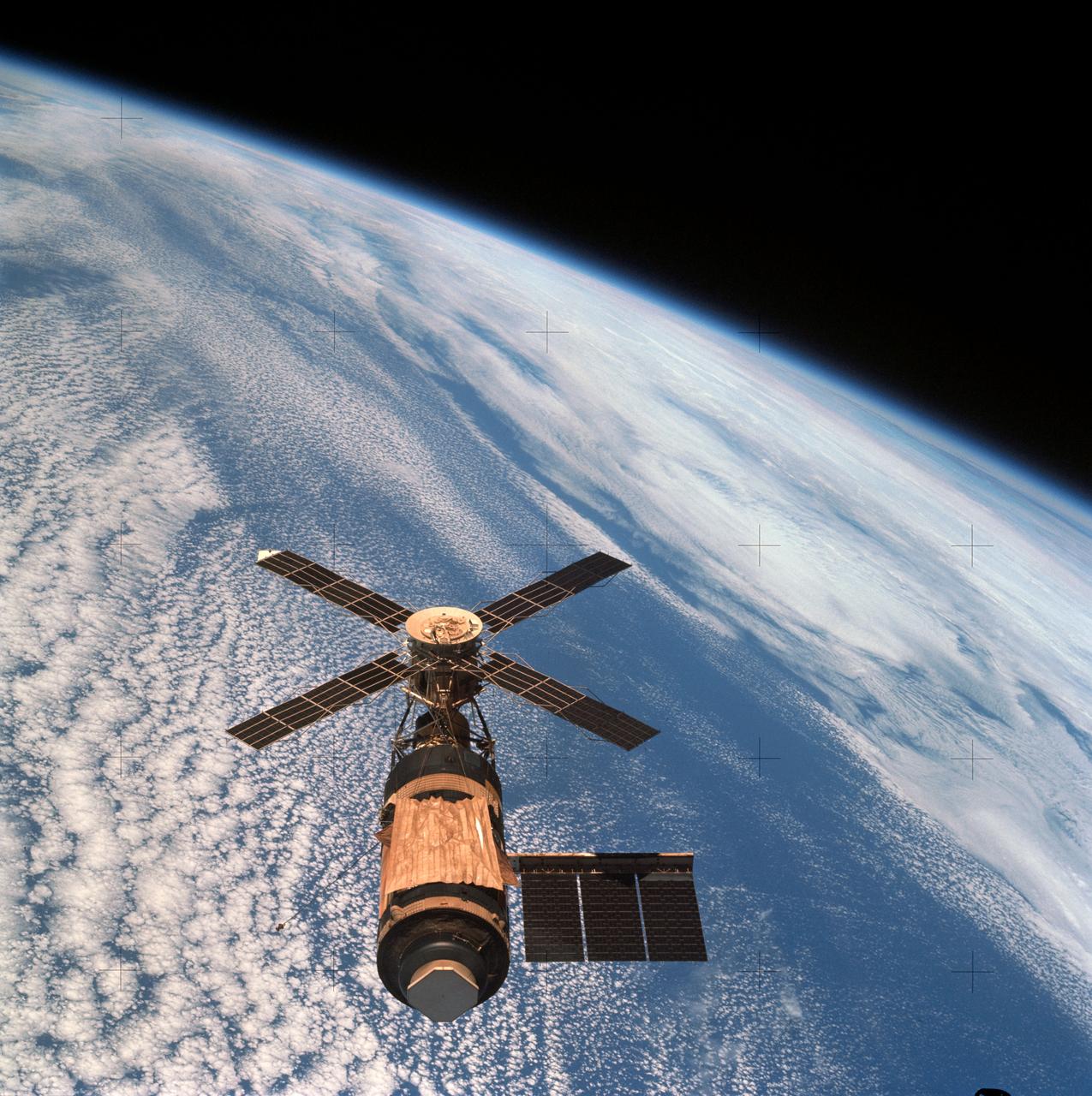
SL4-143-4706 (8 Feb. 1974) --- An overhead view of the Skylab space station cluster in Earth orbit as photographed from the Skylab 4 Command and Service Modules (CSM) during the final fly-around by the CSM before returning home. The space station is contrasted against a cloud-covered Earth. Note the solar shield which was deployed by the second crew of Skylab and from which a micro meteoroid shield has been missing since the cluster was launched on May 14, 1973. The Orbital Workshop (OWS) solar panel on the left side was also lost on workshop launch day. Inside the Command Module (CM) when this picture was made were astronaut Gerald P. Carr, commander; scientist-astronaut Edward G. Gibson, science pilot; and astronaut William R. Pogue, pilot. The crew used a 70mm hand-held Hasselblad camera to take this photograph. Photo credit: NASA

AS11-44-6551 (July 1969) --- This view from the Apollo 11 spacecraft shows the Earth rising above the moon's horizon. The lunar terrain pictured is in the area of Smyth's Sea on the nearside. Coordinates of the center of the terrain are 85 degrees east longitude and 3 degrees north latitude. While astronauts Neil A. Armstrong, commander, and Edwin E. Aldrin Jr., lunar module pilot, descended in the Lunar Module (LM) "Eagle" to explore the Sea of Tranquility region of the moon, astronaut Michael Collins, command module pilot, remained with the Command and Service Modules (CSM) "Columbia" in lunar orbit.
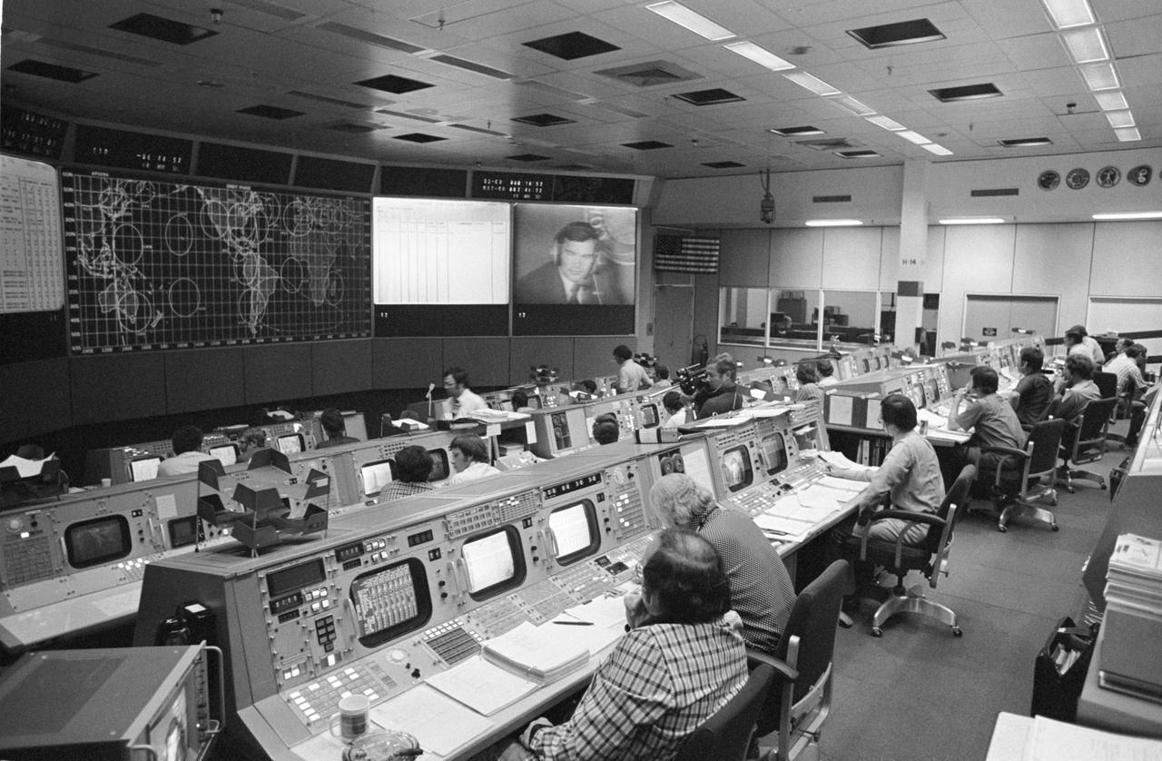
S75-28483 (15 July 1975) --- An overall view of the Mission Operations Control Room in the Mission Control Center on the first day of the Apollo-Soyuz Test Project docking mission in Earth orbit. The American ASTP flight controllers at NASA's Johnson Space Center were monitoring the progress of the Soviet ASTP launch when this photograph was taken. The television monitor shows cosmonaut Yuri V. Romanenko at his spacecraft communicator?s console in the ASTP mission control center in the Soviet Union. The American ASTP liftoff followed the Soviet ASTP launch by seven and one-half hours.

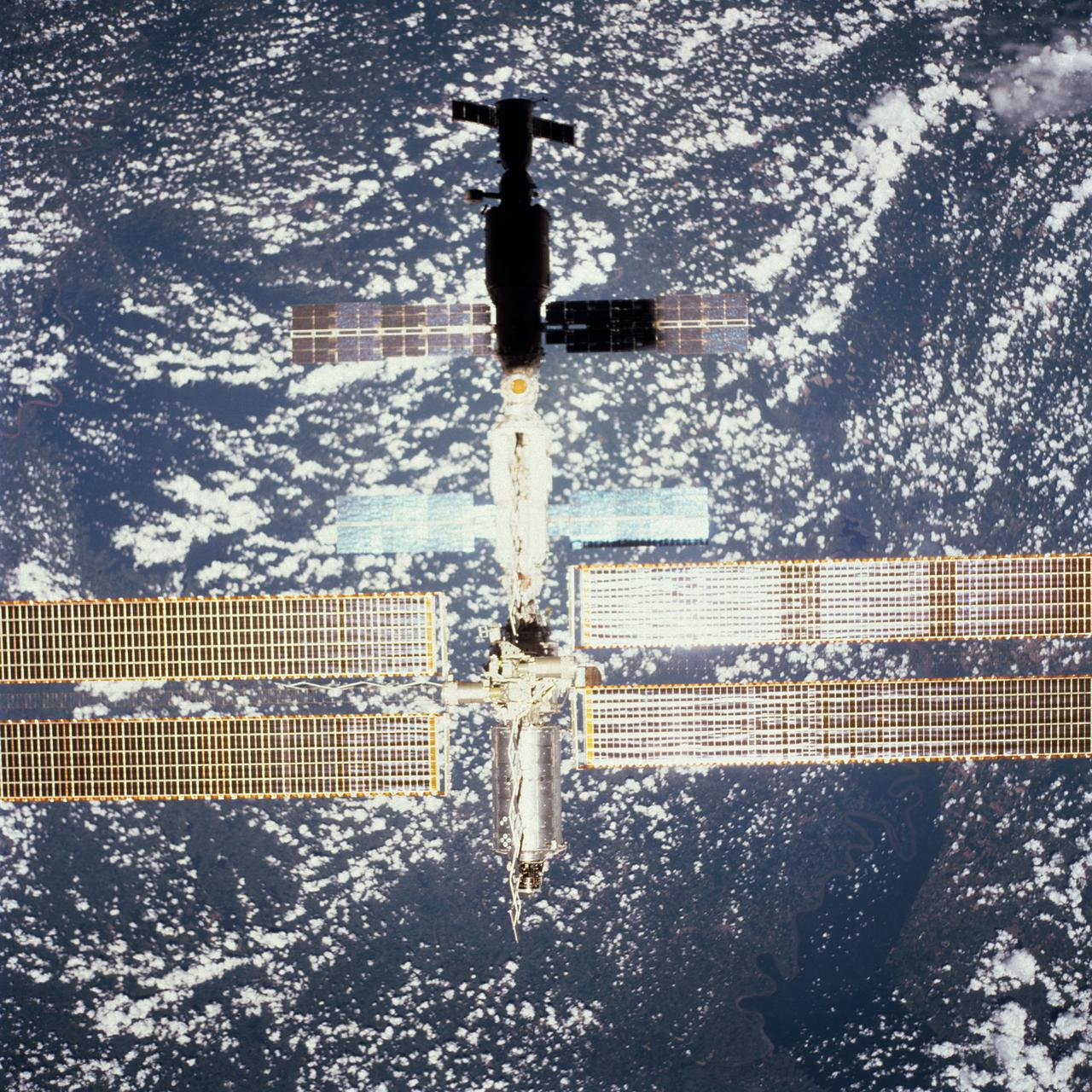
STS111-373-018 (15 June 2002) --- Silhouetted over Earth, this full view of the International Space Station (ISS) was photographed by a crewmember on board the Space Shuttle Endeavour following the undocking of the two spacecraft over western Kazakhstan. Endeavour pulled away from the complex at 9:32 a.m. (CDT) on June 15, 2002.
AS8-15-2561 (21-27 Dec. 1968) --- View of Earth as photographed by the Apollo 8 astronauts on their return trip from the moon. Note that the terminator is straighter than on the outbound pictures. The terminator crosses Australia. India is visible. The sun reflection is within the Indian Ocean.
AS08-16-2596 (21-27 Dec. 1968) --- View of Earth as photographed by the Apollo 8 astronauts during their lunar orbit mission. North is about five percent to the right of vertical. The sunset terminator crosses North and South America. Clouds cover most of the United States. Only the desert southwest and Florida are clear.
View of Moon limb with Earth on the horizon,Mare Smythii Region. Earth rise. This image was taken before separation of the LM and the Command Module during Apollo 11 Mission. Original film magazine was labeled V. Film Type: S0-368 Color taken with a 250mm lens. Approximate photo scale 1:1,300,000. Principal Point Latitude was 3 North by Longitude 85 East. Foward overlap is 90%. Sun angle is High. Approximate Tilt minimum is 65 degrees,maximum is 69. Tilt direction is West (W).

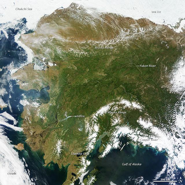
On most days, relentless rivers of clouds wash over Alaska, obscuring most of the state’s 6,640 miles (10,690 kilometers) of coastline and 586,000 square miles (1,518,000 square kilometers) of land. The south coast of Alaska even has the dubious distinction of being the cloudiest region of the United States, with some locations averaging more than 340 cloudy days per year. That was certainly not the case on June 17, 2013, the date that the Moderate Resolution Imaging Spectroradiometer (MODIS) on NASA’s Terra satellite acquired this rare, nearly cloud-free view of the state. The absence of clouds exposed a striking tapestry of water, ice, land, forests, and even wildfires. Snow-covered mountains such as the Alaska Range and Chugach Mountains were visible in southern Alaska, while the arc of mountains that make up the Brooks Range dominated the northern part of the state. The Yukon River—the longest in Alaska and the third longest in the United States—wound its way through the green boreal forests that inhabit the interior of the state. Plumes of sediment and glacial dust poured into the Gulf of Alaska from the Copper River. And Iliamna Lake, the largest in Alaska, was ice free. The same ridge of high pressure that cleared Alaska’s skies also brought stifling temperatures to many areas accustomed to chilly June days. Talkeetna, a town about 100 miles north of Anchorage, saw temperatures reach 96°F (36°C) on June 17. Other towns in southern Alaska set all-time record highs, including Cordova, Valez, and Seward. The high temperatures also helped fuel wildfires and hastened the breakup of sea ice in the Chukchi Sea. NASA image courtesy Jeff Schmaltz, LANCE MODIS Rapid Response Team at NASA GSFC. Caption by Adam Voiland. Instrument: Terra - MODIS More info: <a href="http://1.usa.gov/102MAEj" rel="nofollow">1.usa.gov/102MAEj</a> Credit: <b><a href="http://www.earthobservatory.nasa.gov/" rel="nofollow"> NASA Earth Observatory</a></b> <b><a href="http://www.nasa.gov/audience/formedia/features/MP_Photo_Guidelines.html" rel="nofollow">NASA image use policy.</a></b> <b><a href="http://www.nasa.gov/centers/goddard/home/index.html" rel="nofollow">NASA Goddard Space Flight Center</a></b> enables NASA’s mission through four scientific endeavors: Earth Science, Heliophysics, Solar System Exploration, and Astrophysics. Goddard plays a leading role in NASA’s accomplishments by contributing compelling scientific knowledge to advance the Agency’s mission. <b>Follow us on <a href="http://twitter.com/NASA_GoddardPix" rel="nofollow">Twitter</a></b> <b>Like us on <a href="http://www.facebook.com/pages/Greenbelt-MD/NASA-Goddard/395013845897?ref=tsd" rel="nofollow">Facebook</a></b> <b>Find us on <a href="http://instagram.com/nasagoddard?vm=grid" rel="nofollow">Instagram</a></b>
On most days, relentless rivers of clouds wash over Alaska, obscuring most of the state’s 6,640 miles (10,690 kilometers) of coastline and 586,000 square miles (1,518,000 square kilometers) of land. The south coast of Alaska even has the dubious distinction of being the cloudiest region of the United States, with some locations averaging more than 340 cloudy days per year. That was certainly not the case on June 17, 2013, the date that the Moderate Resolution Imaging Spectroradiometer (MODIS) on NASA’s Terra satellite acquired this rare, nearly cloud-free view of the state. The absence of clouds exposed a striking tapestry of water, ice, land, forests, and even wildfires. Snow-covered mountains such as the Alaska Range and Chugach Mountains were visible in southern Alaska, while the arc of mountains that make up the Brooks Range dominated the northern part of the state. The Yukon River—the longest in Alaska and the third longest in the United States—wound its way through the green boreal forests that inhabit the interior of the state. Plumes of sediment and glacial dust poured into the Gulf of Alaska from the Copper River. And Iliamna Lake, the largest in Alaska, was ice free. The same ridge of high pressure that cleared Alaska’s skies also brought stifling temperatures to many areas accustomed to chilly June days. Talkeetna, a town about 100 miles north of Anchorage, saw temperatures reach 96°F (36°C) on June 17. Other towns in southern Alaska set all-time record highs, including Cordova, Valez, and Seward. The high temperatures also helped fuel wildfires and hastened the breakup of sea ice in the Chukchi Sea. NASA image courtesy Jeff Schmaltz, LANCE MODIS Rapid Response Team at NASA GSFC. Caption by Adam Voiland. Instrument: Terra - MODIS More info: <a href="http://1.usa.gov/102MAEj" rel="nofollow">1.usa.gov/102MAEj</a> Credit: <b><a href="http://www.earthobservatory.nasa.gov/" rel="nofollow"> NASA Earth Observatory</a></b> <b><a href="http://www.nasa.gov/audience/formedia/features/MP_Photo_Guidelines.html" rel="nofollow">NASA image use policy.</a></b> <b><a href="http://www.nasa.gov/centers/goddard/home/index.html" rel="nofollow">NASA Goddard Space Flight Center</a></b> enables NASA’s mission through four scientific endeavors: Earth Science, Heliophysics, Solar System Exploration, and Astrophysics. Goddard plays a leading role in NASA’s accomplishments by contributing compelling scientific knowledge to advance the Agency’s mission. <b>Follow us on <a href="http://twitter.com/NASA_GoddardPix" rel="nofollow">Twitter</a></b> <b>Like us on <a href="http://www.facebook.com/pages/Greenbelt-MD/NASA-Goddard/395013845897?ref=tsd" rel="nofollow">Facebook</a></b> <b>Find us on <a href="http://instagram.com/nasagoddard?vm=grid" rel="nofollow">Instagram</a></b>
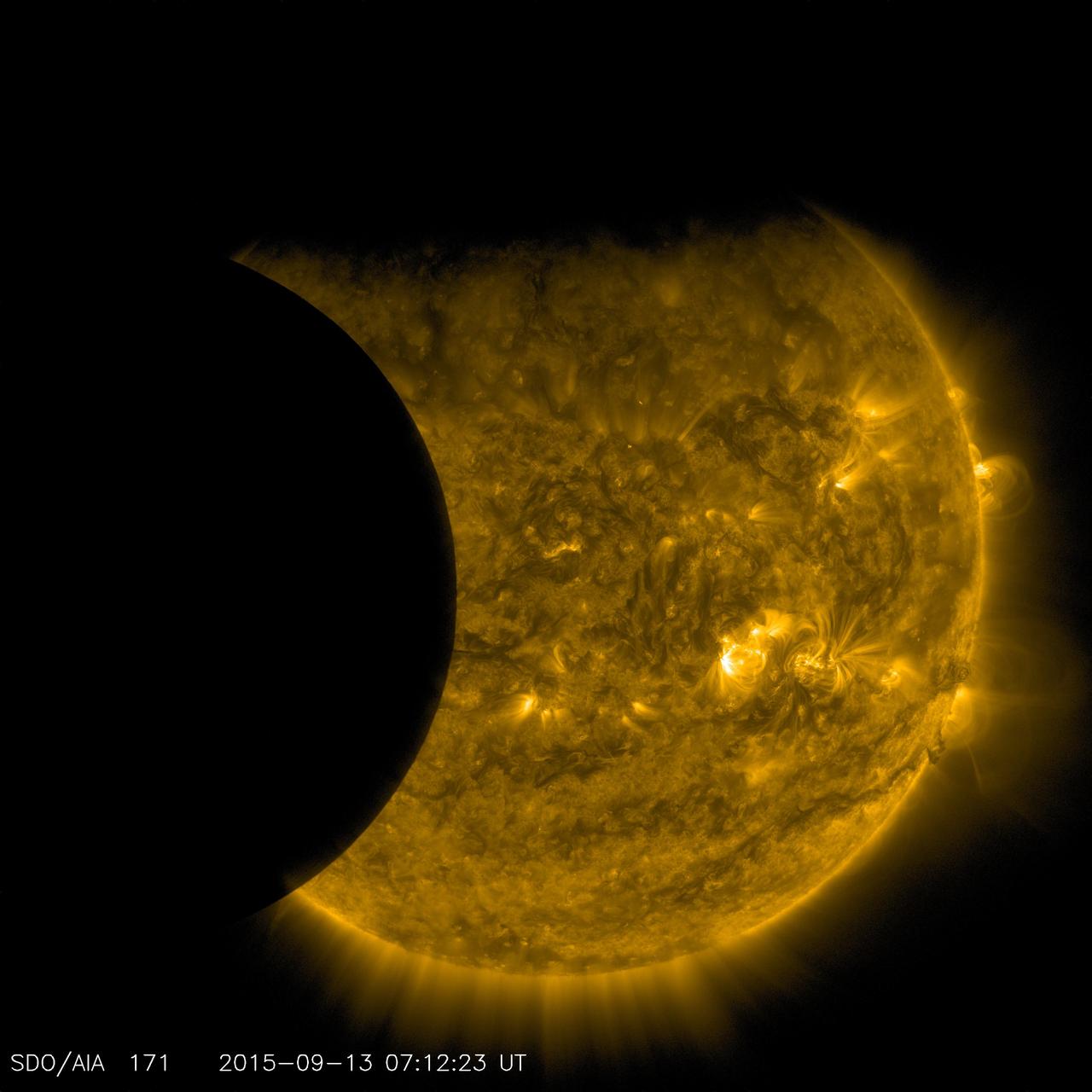
On Sept. 13, 2015, as NASA's Solar Dynamics Observatory, or SDO, kept up its constant watch on the sun, its view was photobombed not once, but twice. Just as the moon came into SDO's field of view on a path to cross the sun, Earth entered the picture, blocking SDO's view completely. When SDO's orbit finally emerged from behind Earth, the moon was just completing its journey across the sun's face. Though SDO sees dozens of Earth eclipses and several lunar transits each year, this is the first time ever that the two have coincided. SDO's orbit usually gives us unobstructed views of the sun, but Earth's revolution around the sun means that SDO's orbit passes behind Earth twice each year, for two to three weeks at a time. During these phases, Earth blocks SDO's view of the sun for anywhere from a few minutes to over an hour once each day. Earth's outline looks fuzzy, while the moon's is crystal-clear. This is because-while the planet itself completely blocks the sun's light-Earth's atmosphere is an incomplete barrier, blocking different amounts of light at different altitudes. However, the moon has no atmosphere, so during the transit we can see the crisp edges of the moon's horizon. http://photojournal.jpl.nasa.gov/catalog/PIA19949
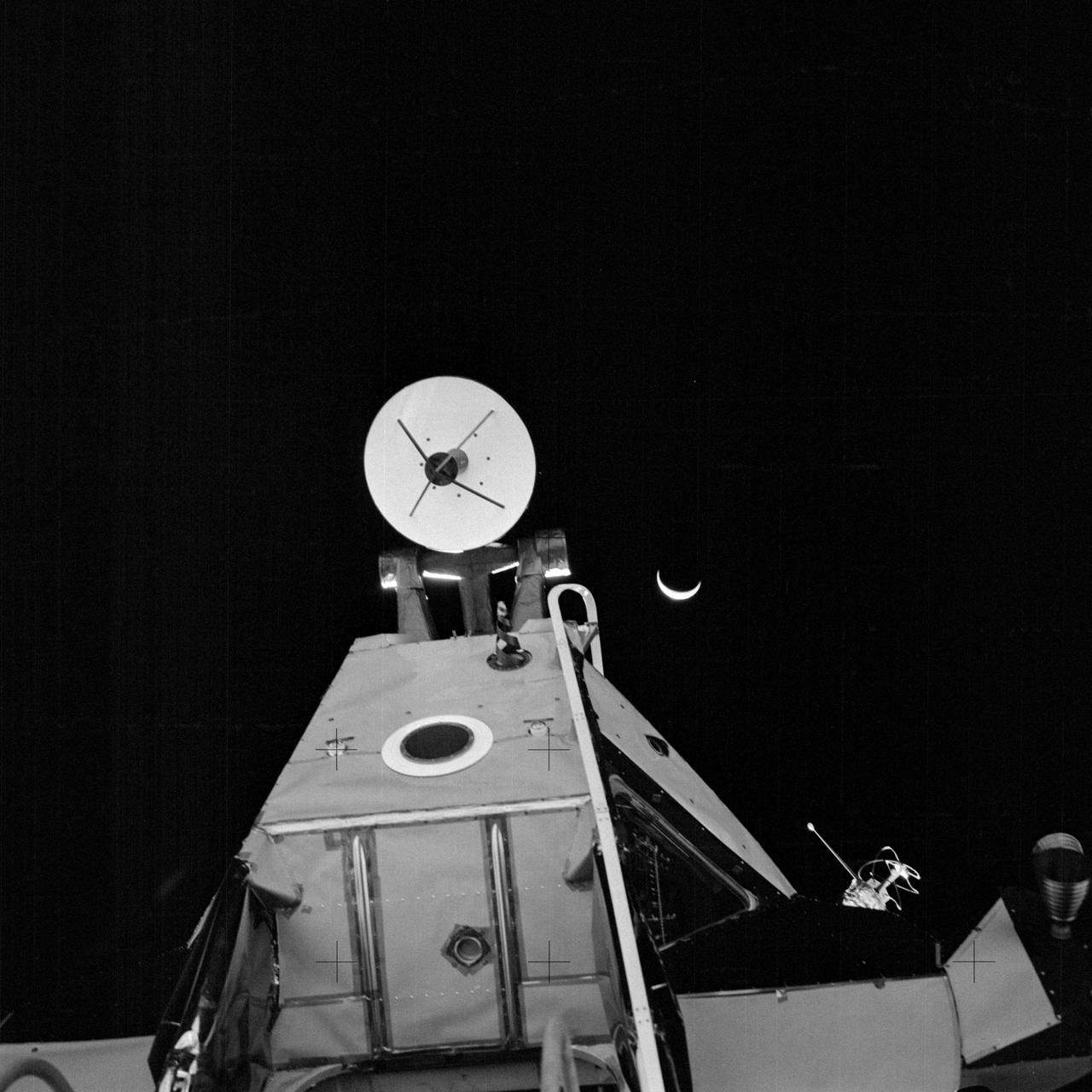
AS14-64-9193 (5 Feb. 1971) --- A close-up view of the forward section of the Apollo 14 Lunar Module (LM) ascent stage, looking upward from the LM ladder. This photograph was taken by one of the Apollo 14 astronauts at the close of their first extravehicular activity (EVA). The LM's ingress/egress hatch is just out of view at the bottom, near center. At the top center is the rendezvous radar antenna. An RCS thruster is visible at the far right. One of the two VHF antennas is on the right. The LM's optical alignment telescope is located at the black circle which has a wide, white ring around it. The crescent Earth can be seen in the far distant background.

January 25, 2012 <b>*Updated February 2, 2012: According to Flickr, "The western hemisphere Blue Marble 2012 image has rocketed up to over 3.1 million views making it one of the all time most viewed images on the site after only one week."</b> A 'Blue Marble' image of the Earth taken from the VIIRS instrument aboard NASA's most recently launched Earth-observing satellite - Suomi NPP. This composite image uses a number of swaths of the Earth's surface taken on January 4, 2012. The NPP satellite was renamed 'Suomi NPP' on January 24, 2012 to honor the late Verner E. Suomi of the University of Wisconsin. Suomi NPP is NASA's next Earth-observing research satellite. It is the first of a new generation of satellites that will observe many facets of our changing Earth. Suomi NPP is carrying five instruments on board. The biggest and most important instrument is The Visible/Infrared Imager Radiometer Suite or VIIRS. To read more about NASA's Suomi NPP go to: <a href="http://www.nasa.gov/npp" rel="nofollow">www.nasa.gov/npp</a> Credit: NASA/NOAA/GSFC/Suomi NPP/VIIRS/Norman Kuring <b><a href="http://www.nasa.gov/audience/formedia/features/MP_Photo_Guidelines.html" rel="nofollow">NASA image use policy.</a></b> <b><a href="http://www.nasa.gov/centers/goddard/home/index.html" rel="nofollow">NASA Goddard Space Flight Center</a></b> enables NASA’s mission through four scientific endeavors: Earth Science, Heliophysics, Solar System Exploration, and Astrophysics. Goddard plays a leading role in NASA’s accomplishments by contributing compelling scientific knowledge to advance the Agency’s mission. <b>Follow us on <a href="http://twitter.com/NASAGoddardPix" rel="nofollow">Twitter</a></b> <b>Like us on <a href="http://www.facebook.com/pages/Greenbelt-MD/NASA-Goddard/395013845897?ref=tsd" rel="nofollow">Facebook</a></b> <b>Find us on <a href="http://instagrid.me/nasagoddard/?vm=grid" rel="nofollow">Instagram</a></b>

This image of the moon was obtained by the Galileo Solid State imaging system on Dec. 8 at 7 p.m. PST as NASA Galileo spacecraft passed the Earth and was able to view the lunar surface from a vantage point not possible from the Earth. http://photojournal.jpl.nasa.gov/catalog/PIA00225
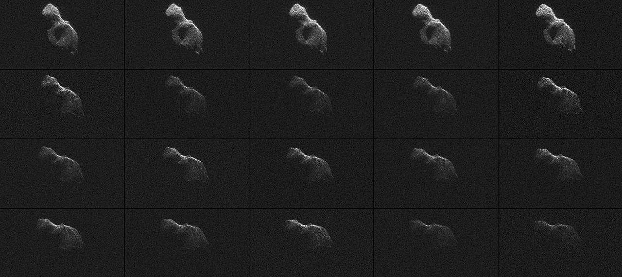
NASA scientists used Earth-based radar to produce these sharp views -- an image montage and a movie sequence -- of the asteroid designated 2014 HQ124 on June 8, 2014.
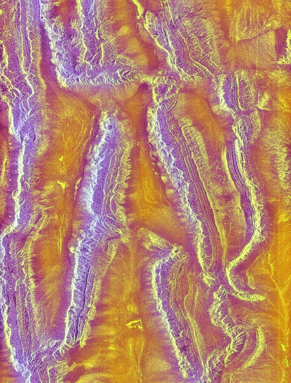
The objective of NASA Shuttle Imaging Radar A SIR-A was to observe the Earth by use of radar imagery, acquire and transmit data of different geologic regions. This is a view of China in 2000.
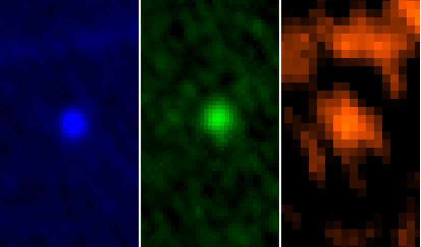
ESA Herschel Space Observatory captured asteroid Apophis in its field of view during the approach to Earth on Jan. 5 and 6, 2013.
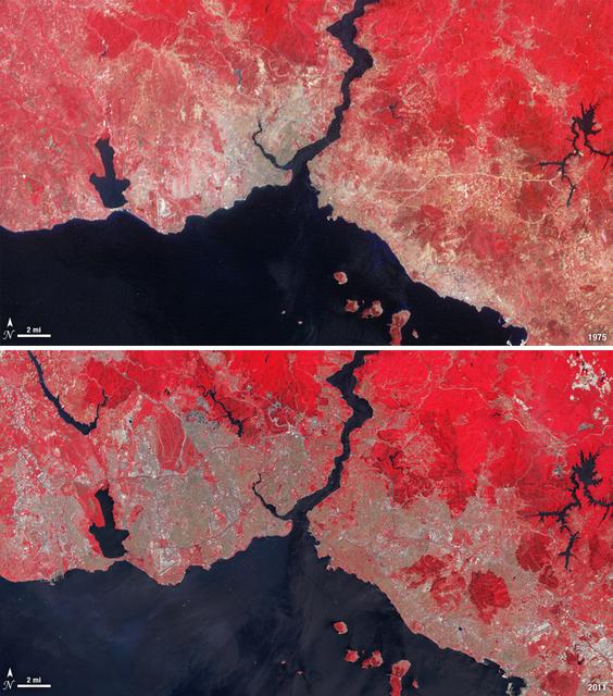
Istanbul has been a bustling trade city for thousands of years. In this 1975 image, taken by Landsat, the city centers on the Golden Horn the estuary that flows into the Bosporus Straight at the center of the scene. Shown in false color, vegetation is red, urban areas are gray, and water appears black. A bridge built in 1973 to connect the Asian and European sides of Istanbul is barely visible. By 2011, Istanbul's population had exploded from 2 to 13 million people, and the city has gone through a dramatic expansion. This Landsat 5 image shows densely packed urban areas stretching along the Sea of Marmara and up the Bosporus Straight where a second bridge built in 1988 now crosses the water. ---- NASA and the U.S. Department of the Interior through the U.S. Geological Survey (USGS) jointly manage Landsat, and the USGS preserves a 40-year archive of Landsat images that is freely available over the Internet. The next Landsat satellite, now known as the Landsat Data Continuity Mission (LDCM) and later to be called Landsat 8, is scheduled for launch in 2013. In honor of Landsat’s 40th anniversary in July 2012, the USGS released the LandsatLook viewer – a quick, simple way to go forward and backward in time, pulling images of anywhere in the world out of the Landsat archive. <b><a href="http://www.nasa.gov/audience/formedia/features/MP_Photo_Guidelines.html" rel="nofollow">NASA image use policy.</a></b> <b><a href="http://www.nasa.gov/centers/goddard/home/index.html" rel="nofollow">NASA Goddard Space Flight Center</a></b> enables NASA’s mission through four scientific endeavors: Earth Science, Heliophysics, Solar System Exploration, and Astrophysics. Goddard plays a leading role in NASA’s accomplishments by contributing compelling scientific knowledge to advance the Agency’s mission. <b>Follow us on <a href="http://twitter.com/NASA_GoddardPix" rel="nofollow">Twitter</a></b> <b>Like us on <a href="http://www.facebook.com/pages/Greenbelt-MD/NASA-Goddard/395013845897?ref=tsd" rel="nofollow">Facebook</a></b> <b>Find us on <a href="http://instagrid.me/nasagoddard/?vm=grid" rel="nofollow">Instagram</a></b>
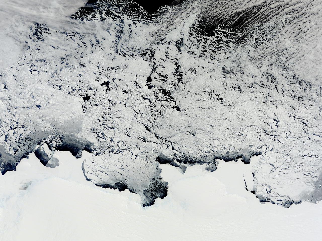
NASA image acquired November 2, 2011 The Moderate Resolution Imaging Spectroradiometer (MODIS) instrument on NASA's Terra satellite captured this image of the Knox, Budd Law Dome, and Sabrina Coasts, Antarctica on November 2, 2011 at 01:40 UTC (Nov. 1 at 9:40 p.m. EDT). Operation Ice Bridge is exploring Antarctic ice, and more information can be found at <a href="http://www.nasa.gov/icebridge" rel="nofollow">www.nasa.gov/icebridge</a>. Image Credit: NASA Goddard MODIS Rapid Response Team <b><a href="http://www.nasa.gov/audience/formedia/features/MP_Photo_Guidelines.html" rel="nofollow">NASA image use policy.</a></b> <b><a href="http://www.nasa.gov/centers/goddard/home/index.html" rel="nofollow">NASA Goddard Space Flight Center</a></b> enables NASA’s mission through four scientific endeavors: Earth Science, Heliophysics, Solar System Exploration, and Astrophysics. Goddard plays a leading role in NASA’s accomplishments by contributing compelling scientific knowledge to advance the Agency’s mission. <b>Follow us on <a href="http://twitter.com/NASA_GoddardPix" rel="nofollow">Twitter</a></b> <b>Like us on <a href="http://www.facebook.com/pages/Greenbelt-MD/NASA-Goddard/395013845897?ref=tsd" rel="nofollow">Facebook</a></b> <b>Find us on <a href="http://instagrid.me/nasagoddard/?vm=grid" rel="nofollow">Instagram</a></b>
art002e000180 (April 1, 2026) - This black and white image of Earth was captured by the optical navigation sensor on the exterior of the Orion spacecraft on the first day of the Artemis II mission, as the four astronauts inside were traveling farther than any humans have ventured in more than 50 years.
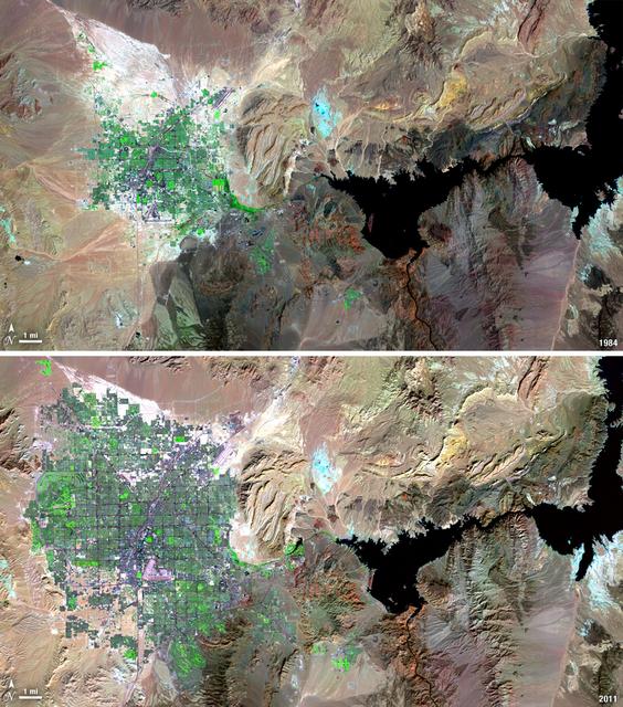
Over the years of the Landsat program, the desert city of Las Vegas has gone through a massive growth spurt. The outward expansion of the city over the last quarter of a century is shown here with two false-color Landsat 5 images (August 3, 1984, and November 2, 2011). The dark purple grid of city streets and the green of irrigated vegetation grow out in every direction into the surrounding desert. These images were created using reflected light from the shortwave infrared, near-infrared, and green portions of the electromagnetic spectrum (Landsat 5 TM bands 7,4,2). ---- NASA and the U.S. Department of the Interior through the U.S. Geological Survey (USGS) jointly manage Landsat, and the USGS preserves a 40-year archive of Landsat images that is freely available over the Internet. The next Landsat satellite, now known as the Landsat Data Continuity Mission (LDCM) and later to be called Landsat 8, is scheduled for launch in 2013. In honor of Landsat’s 40th anniversary in July 2012, the USGS released the LandsatLook viewer – a quick, simple way to go forward and backward in time, pulling images of anywhere in the world out of the Landsat archive. <b><a href="http://www.nasa.gov/audience/formedia/features/MP_Photo_Guidelines.html" rel="nofollow">NASA image use policy.</a></b> <b><a href="http://www.nasa.gov/centers/goddard/home/index.html" rel="nofollow">NASA Goddard Space Flight Center</a></b> enables NASA’s mission through four scientific endeavors: Earth Science, Heliophysics, Solar System Exploration, and Astrophysics. Goddard plays a leading role in NASA’s accomplishments by contributing compelling scientific knowledge to advance the Agency’s mission. <b>Follow us on <a href="http://twitter.com/NASA_GoddardPix" rel="nofollow">Twitter</a></b> <b>Like us on <a href="http://www.facebook.com/pages/Greenbelt-MD/NASA-Goddard/395013845897?ref=tsd" rel="nofollow">Facebook</a></b> <b>Find us on <a href="http://instagrid.me/nasagoddard/?vm=grid" rel="nofollow">Instagram</a></b>
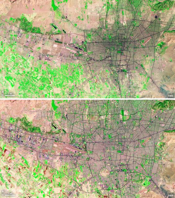
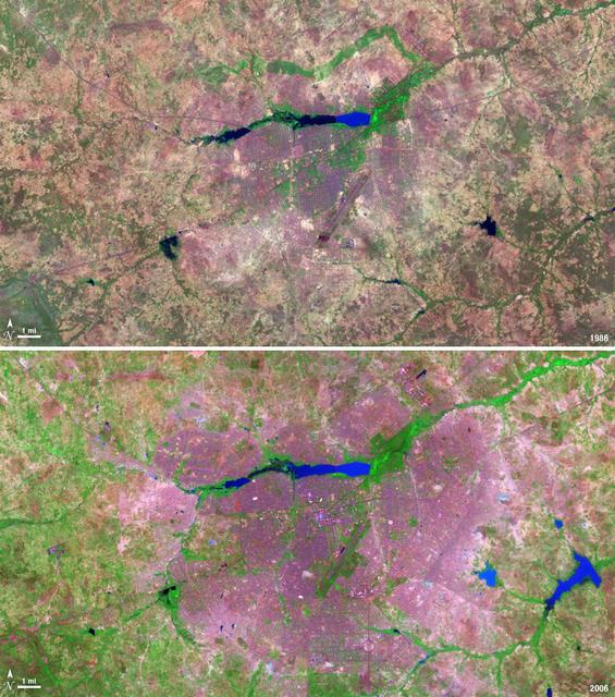
Between 1985 and 2009, the population of Tehran, Iran, grew from six million to just over seven million. The city's growth was spurred largely by migration from other parts of the country. In addition to being the hub of government and associated public sector jobs, Tehran houses more than half of Iran's industry. Landsat 5 acquired these false-color images of Tehran on August 2, 1985, and July 19, 2009. The city is a web of dark purple lines, vegetation is green and bare ground is pink and tan. The images were created using both infrared and visible light (band combination 7, 4, and 2) to distinguish urban areas from the surrounding desert. ---- NASA and the U.S. Department of the Interior through the U.S. Geological Survey (USGS) jointly manage Landsat, and the USGS preserves a 40-year archive of Landsat images that is freely available over the Internet. The next Landsat satellite, now known as the Landsat Data Continuity Mission (LDCM) and later to be called Landsat 8, is scheduled for launch in 2013. In honor of Landsat’s 40th anniversary in July 2012, the USGS released the LandsatLook viewer – a quick, simple way to go forward and backward in time, pulling images of anywhere in the world out of the Landsat archive. <b><a href="http://www.nasa.gov/audience/formedia/features/MP_Photo_Guidelines.html" rel="nofollow">NASA image use policy.</a></b> <b><a href="http://www.nasa.gov/centers/goddard/home/index.html" rel="nofollow">NASA Goddard Space Flight Center</a></b> enables NASA’s mission through four scientific endeavors: Earth Science, Heliophysics, Solar System Exploration, and Astrophysics. Goddard plays a leading role in NASA’s accomplishments by contributing compelling scientific knowledge to advance the Agency’s mission. <b>Follow us on <a href="http://twitter.com/NASA_GoddardPix" rel="nofollow">Twitter</a></b> <b>Like us on <a href="http://www.facebook.com/pages/Greenbelt-MD/NASA-Goddard/395013845897?ref=tsd" rel="nofollow">Facebook</a></b> <b>Find us on <a href="http://instagrid.me/nasagoddard/?vm=grid" rel="nofollow">Instagram</a></b>
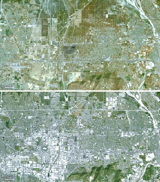
Thirty-five miles due east of downtown Los Angeles lies the city of Ontario, California. In 1881 two Canadian brothers established the town, naming it after their native city. By 1891 Ontario, Calif., was incorporated as a city. The farming-based economy (olives, citrus, dairy) of the city helped it grow to 20,000 by the 1960s. Subsequently, warehousing and freight trafficking took over as the major industry and the city’s population was over 160,000 by 2010. The L.A./Ontario International Airport is now America’s 15th busiest cargo airport. In these natural color Landsat 5 images, the massive growth of the city between 1985 and 2010 can be seen. The airport, found in the southwest portion of the images, added a number of runways and large warehousing structures now dominate the once rural areas surrounding the airport. In these images vegetation is green and brown and urban structures are bright white and gray. (Note there is a large dry riverbed in the northeast corner that is also bright white, but its nonlinear appearance sets it apart visually). ---- NASA and the U.S. Department of the Interior through the U.S. Geological Survey (USGS) jointly manage Landsat, and the USGS preserves a 40-year archive of Landsat images that is freely available over the Internet. The next Landsat satellite, now known as the Landsat Data Continuity Mission (LDCM) and later to be called Landsat 8, is scheduled for launch in 2013. In honor of Landsat’s 40th anniversary in July 2012, the USGS released the LandsatLook viewer – a quick, simple way to go forward and backward in time, pulling images of anywhere in the world out of the Landsat archive. <b><a href="http://www.nasa.gov/audience/formedia/features/MP_Photo_Guidelines.html" rel="nofollow">NASA image use policy.</a></b> <b><a href="http://www.nasa.gov/centers/goddard/home/index.html" rel="nofollow">NASA Goddard Space Flight Center</a></b> enables NASA’s mission through four scientific endeavors: Earth Science, Heliophysics, Solar System Exploration, and Astrophysics. Goddard plays a leading role in NASA’s accomplishments by contributing compelling scientific knowledge to advance the Agency’s mission. <b>Follow us on <a href="http://twitter.com/NASA_GoddardPix" rel="nofollow">Twitter</a></b> <b>Like us on <a href="http://www.facebook.com/pages/Greenbelt-MD/NASA-Goddard/395013845897?ref=tsd" rel="nofollow">Facebook</a></b> <b>Find us on <a href="http://instagrid.me/nasagoddard/?vm=grid" rel="nofollow">Instagram</a></b>
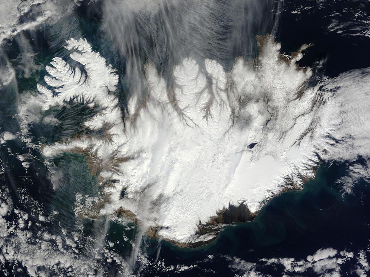
This nearly cloud-free image of Iceland was captured by the MODIS instrument on board the Terra spacecraft on 04/15/2015 at 13:00 UTC. <b><a href="http://www.nasa.gov/audience/formedia/features/MP_Photo_Guidelines.html" rel="nofollow">NASA image use policy.</a></b> <b><a href="http://www.nasa.gov/centers/goddard/home/index.html" rel="nofollow">NASA Goddard Space Flight Center</a></b> enables NASA’s mission through four scientific endeavors: Earth Science, Heliophysics, Solar System Exploration, and Astrophysics. Goddard plays a leading role in NASA’s accomplishments by contributing compelling scientific knowledge to advance the Agency’s mission. <b>Follow us on <a href="http://twitter.com/NASAGoddardPix" rel="nofollow">Twitter</a></b> <b>Like us on <a href="http://www.facebook.com/pages/Greenbelt-MD/NASA-Goddard/395013845897?ref=tsd" rel="nofollow">Facebook</a></b> <b>Find us on <a href="http://instagrid.me/nasagoddard/?vm=grid" rel="nofollow">Instagram</a></b>
The landlocked western African nation of Burkina Faso experienced a 200 percent increase in urban population between 1975 and 2000. As a result, the area of the capital city Ouagadougou grew 14-fold during this period. These Landsat images show the city expanding outward from its center in the two decades between 1986 and 2006. On Nov. 18, 1986, the Landsat 5 satellite acquired this image of the capital. This false-color image shows vegetation in shades of green and gray, water in various shades of blue, and urban areas in pink and purple. The runway of the city’s airport can be seen as a long straight line that extends from southwest to northeast south of the large lake, Bois de Boulogne. Two decades later, on Oct. 16, 2006 Landsat 7 acquired this image of Ouagadougou. Growth radiated from the city center in all directions. The green strip of vegetation north of Bois de Boulogne has been paved over and a massive new development including a large thoroughfare and traffic circle can be seen south of the airport. ---- NASA and the U.S. Department of the Interior through the U.S. Geological Survey (USGS) jointly manage Landsat, and the USGS preserves a 40-year archive of Landsat images that is freely available over the Internet. The next Landsat satellite, now known as the Landsat Data Continuity Mission (LDCM) and later to be called Landsat 8, is scheduled for launch in 2013. In honor of Landsat’s 40th anniversary in July 2012, the USGS released the LandsatLook viewer – a quick, simple way to go forward and backward in time, pulling images of anywhere in the world out of the Landsat archive. <b><a href="http://www.nasa.gov/audience/formedia/features/MP_Photo_Guidelines.html" rel="nofollow">NASA image use policy.</a></b> <b><a href="http://www.nasa.gov/centers/goddard/home/index.html" rel="nofollow">NASA Goddard Space Flight Center</a></b> enables NASA’s mission through four scientific endeavors: Earth Science, Heliophysics, Solar System Exploration, and Astrophysics. Goddard plays a leading role in NASA’s accomplishments by contributing compelling scientific knowledge to advance the Agency’s mission. <b>Follow us on <a href="http://twitter.com/NASA_GoddardPix" rel="nofollow">Twitter</a></b> <b>Like us on <a href="http://www.facebook.com/pages/Greenbelt-MD/NASA-Goddard/395013845897?ref=tsd" rel="nofollow">Facebook</a></b> <b>Find us on <a href="http://instagrid.me/nasagoddard/?vm=grid" rel="nofollow">Instagram</a></b>
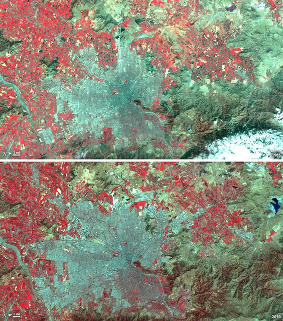
Santiago, Chile, ranks among the world's fastest growing cities. Chile is South America's fifth largest economy with strong export and tourism markets. More than a third of Chile's population lives in Santiago as of 2009. Taken on January 9, 1985, and January 30, 2010, this pair of images from the Landsat 5 satellite illustrates the city's steady growth. The images were made with infrared and visible light (Landsat bands 4, 3, and 2) so that plant-covered land is red. Bare or sparsely vegetated land is tan, and the city is dark silver. In the fifteen years that elapsed between 1985 and 2010, the city expanded away from the Andes Mountains along spoke-like lines, which are major roads. ---- NASA and the U.S. Department of the Interior through the U.S. Geological Survey (USGS) jointly manage Landsat, and the USGS preserves a 40-year archive of Landsat images that is freely available over the Internet. The next Landsat satellite, now known as the Landsat Data Continuity Mission (LDCM) and later to be called Landsat 8, is scheduled for launch in 2013. In honor of Landsat’s 40th anniversary in July 2012, the USGS released the LandsatLook viewer – a quick, simple way to go forward and backward in time, pulling images of anywhere in the world out of the Landsat archive. <b><a href="http://www.nasa.gov/audience/formedia/features/MP_Photo_Guidelines.html" rel="nofollow">NASA image use policy.</a></b> <b><a href="http://www.nasa.gov/centers/goddard/home/index.html" rel="nofollow">NASA Goddard Space Flight Center</a></b> enables NASA’s mission through four scientific endeavors: Earth Science, Heliophysics, Solar System Exploration, and Astrophysics. Goddard plays a leading role in NASA’s accomplishments by contributing compelling scientific knowledge to advance the Agency’s mission. <b>Follow us on <a href="http://twitter.com/NASA_GoddardPix" rel="nofollow">Twitter</a></b> <b>Like us on <a href="http://www.facebook.com/pages/Greenbelt-MD/NASA-Goddard/395013845897?ref=tsd" rel="nofollow">Facebook</a></b> <b>Find us on <a href="http://instagrid.me/nasagoddard/?vm=grid" rel="nofollow">Instagram</a></b>

Over the last 25 years, Chandler, Arizona has traded its grid of fields for a grid of streets. Founded in 1912 on cotton, grains, alfalfa, and ostrich farms, brown and green irrigated fields still dominate the region southeast of Phoenix in this 1985 natural color image taken by Landsat 5. By 2011, the blue gray city streets in this Landsat 5 image have taken over. Chandler's economy has shifted from agriculture to manufacturing and electronics, and its population boomed from 30,000 people in 1980 to 236,000 in 2010. ---- Survey (USGS) jointly manage Landsat, and the USGS preserves a 40-year archive of Landsat images that is freely available over the Internet. The next Landsat satellite, now known as the Landsat Data Continuity Mission (LDCM) and later to be called Landsat 8, is scheduled for launch in 2013. In honor of Landsat’s 40th anniversary in July 2012, the USGS released the LandsatLook viewer – a quick, simple way to go forward and backward in time, pulling images of anywhere in the world out of the Landsat archive. <b><a href="http://www.nasa.gov/audience/formedia/features/MP_Photo_Guidelines.html" rel="nofollow">NASA image use policy.</a></b> <b><a href="http://www.nasa.gov/centers/goddard/home/index.html" rel="nofollow">NASA Goddard Space Flight Center</a></b> enables NASA’s mission through four scientific endeavors: Earth Science, Heliophysics, Solar System Exploration, and Astrophysics. Goddard plays a leading role in NASA’s accomplishments by contributing compelling scientific knowledge to advance the Agency’s mission. <b>Follow us on <a href="http://twitter.com/NASA_GoddardPix" rel="nofollow">Twitter</a></b> <b>Like us on <a href="http://www.facebook.com/pages/Greenbelt-MD/NASA-Goddard/395013845897?ref=tsd" rel="nofollow">Facebook</a></b> <b>Find us on <a href="http://instagrid.me/nasagoddard/?vm=grid" rel="nofollow">Instagram</a></b>
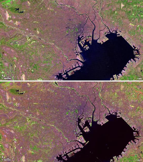
Tokyo is the world’s largest metropolitan region, home to nearly 37 million people. During the past two decades, Tokyo’s population has grown by more than 7 million. The city’s growth has continued despite Japan’s overall stagnating population, mainly due to a continued trend of centralization—citizens moving out of the country and into the city. Landsat 4 collected this first false-color image of Tokyo on Feb. 2, 1989. The upper half of Tokyo Bay is the large water body visible in a dark blue. In the middle of the image, central Tokyo appears a deep purple just north of the bay. Twenty-two years later, Landsat 5, captured this second image of Tokyo on April 5, 2011. The urban reaches of metropolitan Tokyo have grown in both distance and density, as seen where the green color of vegetation has turned to pink and purple shades of urbanization. A major expansion of Tokyo’s Haneda Airport, can be seen south of the city, on land built out into the bay. The constant circular spot of green in the dense city-center, visible on both images, is the Tokyo Imperial Palace and its gardens. (Landsat 5 TM Bands 7,4,2) ---- NASA and the U.S. Department of the Interior through the U.S. Geological Survey (USGS) jointly manage Landsat, and the USGS preserves a 40-year archive of Landsat images that is freely available over the Internet. The next Landsat satellite, now known as the Landsat Data Continuity Mission (LDCM) and later to be called Landsat 8, is scheduled for launch in 2013. In honor of Landsat’s 40th anniversary in July 2012, the USGS released the LandsatLook viewer – a quick, simple way to go forward and backward in time, pulling images of anywhere in the world out of the Landsat archive. <b><a href="http://www.nasa.gov/audience/formedia/features/MP_Photo_Guidelines.html" rel="nofollow">NASA image use policy.</a></b> <b><a href="http://www.nasa.gov/centers/goddard/home/index.html" rel="nofollow">NASA Goddard Space Flight Center</a></b> enables NASA’s mission through four scientific endeavors: Earth Science, Heliophysics, Solar System Exploration, and Astrophysics. Goddard plays a leading role in NASA’s accomplishments by contributing compelling scientific knowledge to advance the Agency’s mission. <b>Follow us on <a href="http://twitter.com/NASA_GoddardPix" rel="nofollow">Twitter</a></b> <b>Like us on <a href="http://www.facebook.com/pages/Greenbelt-MD/NASA-Goddard/395013845897?ref=tsd" rel="nofollow">Facebook</a></b> <b>Find us on <a href="http://instagrid.me/nasagoddard/?vm=grid" rel="nofollow">Instagram</a></b>

STS047-54-016 (12 - 20 Sept 1992) --- The colors in this photograph provide insight into the relative density of the atmosphere. The crew members had many opportunities to witness sunrises and sunsets, considering they orbit the Earth every 90 minutes, but few, they said, compared to this scene. It captures the silhouette of several mature thunderstorms with their cirrus anvil tops spreading out against the tropopause (the top of the lowest layer of Earth's atmosphere) at sunset. The lowest layer (troposphere) is the densest and refracts light at the red end of the visible spectrum (7,400 Angstroms), while the blues (4,000 Angstroms) are separated in the least dense portion of the atmosphere (middle and upper atmosphere, or stratosphere and mesosphere). Several layers of blue can be seen. NASA scientists studying the photos believe this stratification to be caused by the scattering of light by particulate trapped in the stratosphere and mesosphere particulate that generally originate from volcanic eruptions, such as those of Mt. Pinatubo in the Philippines and, most recently, Mt. Spurr in Alaska.