
From left to right, Ecuador Minster of Production, Foreign Trade, Investments and Fisheries Julio José Prado, Ambassador of Ecuador to the United States Ivonne A-Baki, Ecuador Minister of Foreign Affairs and Human Mobility Gustavo Manrique Miranda, U.S. Department of State Director of the Office of Space Affairs Valda Vikmanis Keller, and NASA Associate Administrator for International and Interagency Relations Karen Feldstein, pose for a photo during an Artemis Accords signing ceremony, Wednesday, June 21, 2023, at the Embassy of Ecuador in Washington. Ecuador is the twenty sixth country to sign the Artemis Accords, which establish a practical set of principles to guide space exploration cooperation among nations participating in NASA’s Artemis program. Photo Credit: (NASA/Keegan Barber)

Ambassador of Ecuador to the United States Ivonne A-Baki, left, delivers remarks during an Artemis Accords signing ceremony Wednesday, June 21, 2023, at the Embassy of Ecuador in Washington. Ecuador is the twenty sixth country to sign the Artemis Accords, which establish a practical set of principles to guide space exploration cooperation among nations participating in NASA’s Artemis program. Photo Credit: (NASA/Keegan Barber)

Ecuador Minster of Production, Foreign Trade, Investments and Fisheries Julio José Prado, left, delivers remarks during an Artemis Accords signing ceremony Wednesday, June 21, 2023, at the Embassy of Ecuador in Washington. Ecuador is the twenty sixth country to sign the Artemis Accords, which establish a practical set of principles to guide space exploration cooperation among nations participating in NASA’s Artemis program. Photo Credit: (NASA/Keegan Barber)

Ecuador Minister of Foreign Affairs and Human Mobility Gustavo Manrique Miranda signs the Artemis Accords, Wednesday, June 21, 2023, at the Embassy of Ecuador in Washington. Ecuador is the twenty sixth country to sign the Artemis Accords, which establish a practical set of principles to guide space exploration cooperation among nations participating in NASA’s Artemis program. Photo Credit: (NASA/Keegan Barber)

Ecuador Minister of Foreign Affairs and Human Mobility Gustavo Manrique Miranda signs the Artemis Accords, Wednesday, June 21, 2023, at the Embassy of Ecuador in Washington. Ecuador is the twenty sixth country to sign the Artemis Accords, which establish a practical set of principles to guide space exploration cooperation among nations participating in NASA’s Artemis program. Photo Credit: (NASA/Keegan Barber)

Ecuador Minister of Foreign Affairs and Human Mobility Gustavo Manrique Miranda, center, delivers remarks during an Artemis Accords signing ceremony Wednesday, June 21, 2023, at the Embassy of Ecuador in Washington. Ecuador is the twenty sixth country to sign the Artemis Accords, which establish a practical set of principles to guide space exploration cooperation among nations participating in NASA’s Artemis program. Photo Credit: (NASA/Keegan Barber)

Ecuador Minister of Foreign Affairs and Human Mobility Gustavo Manrique Miranda delivers remarks during an Artemis Accords signing ceremony Wednesday, June 21, 2023, at the Embassy of Ecuador in Washington. Ecuador is the twenty sixth country to sign the Artemis Accords, which establish a practical set of principles to guide space exploration cooperation among nations participating in NASA’s Artemis program. Photo Credit: (NASA/Keegan Barber)

U.S. Department of State Director of the Office of Space Affairs Valda Vikmanis Keller, right, delivers remarks during an Artemis Accords signing ceremony Wednesday, June 21, 2023, at the Embassy of Ecuador in Washington. Ecuador is the twenty sixth country to sign the Artemis Accords, which establish a practical set of principles to guide space exploration cooperation among nations participating in NASA’s Artemis program. Photo Credit: (NASA/Keegan Barber)

NASA Associate Administrator for International and Interagency Relations Karen Feldstein, right, delivers remarks during an Artemis Accords signing ceremony Wednesday, June 21, 2023, at the Embassy of Ecuador in Washington. Ecuador is the twenty sixth country to sign the Artemis Accords, which establish a practical set of principles to guide space exploration cooperation among nations participating in NASA’s Artemis program. Photo Credit: (NASA/Keegan Barber)

NASA Associate Administrator for International and Interagency Relations Karen Feldstein, right, delivers remarks during an Artemis Accords signing ceremony Wednesday, June 21, 2023, at the Embassy of Ecuador in Washington. Ecuador is the twenty sixth country to sign the Artemis Accords, which establish a practical set of principles to guide space exploration cooperation among nations participating in NASA’s Artemis program. Photo Credit: (NASA/Keegan Barber)

NASA Associate Administrator for International and Interagency Relations Karen Feldstein, right, delivers remarks during an Artemis Accords signing ceremony Wednesday, June 21, 2023, at the Embassy of Ecuador in Washington. Ecuador is the twenty sixth country to sign the Artemis Accords, which establish a practical set of principles to guide space exploration cooperation among nations participating in NASA’s Artemis program. Photo Credit: (NASA/Keegan Barber)
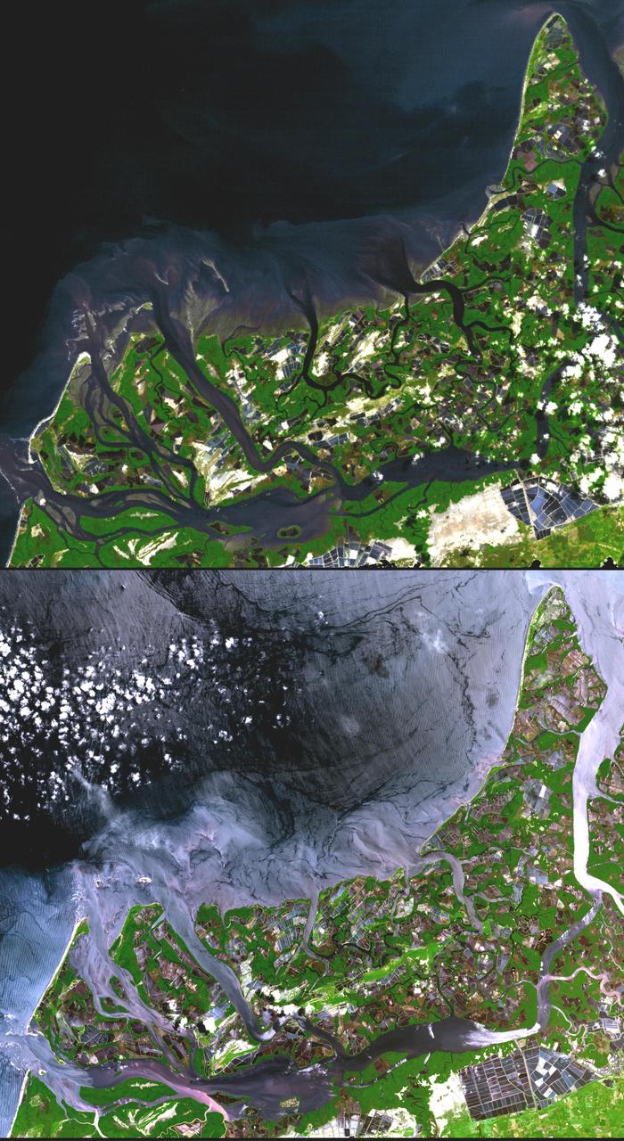
In many parts of the world, wetlands are being converted to shrimp ponds in order to farm these crustaceans for food and sale. One example is on the west coast of Ecuador, south of Guayaquil. This image was acquired by NASA Terra spacecraft.
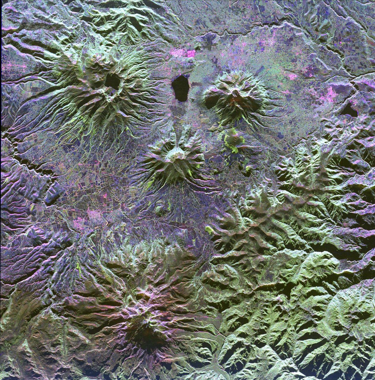
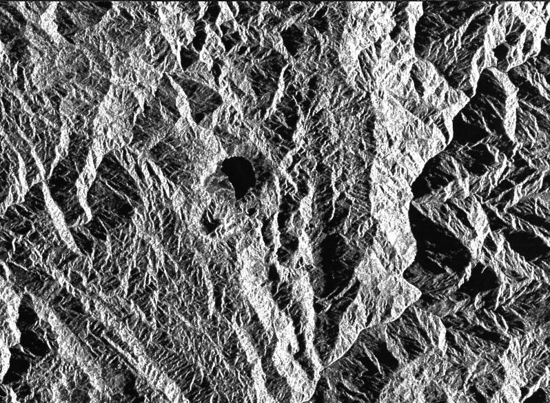
A family of dormant volcanoes dominates the landscape in this radar image of the Andes Mountains in northern Ecuador. The city of Otavalo, shown in pink, and Lake Otavalo lie within the triangle formed by three volcanoes in the upper part of the image.
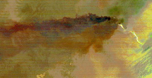
Sangay Volcano, Ecuador, erupted in early June, sending lava flows and pyroclastic flows down its southeastern flank. A large ash plume rose above 7 km, and was blown westward by the prevailing winds. Ashfall was reported in several cities downwind. The nighttime thermal infrared image acquired by ASTER on June 11 shows the flows in white, and the large ash plume in dark red-brown, indicating its composition is dominated by ash particles. The image covers an area of 24.5 by 46.8 km, and is located at 2 degrees south, 78.4 degrees west. https://photojournal.jpl.nasa.gov/catalog/PIA23914
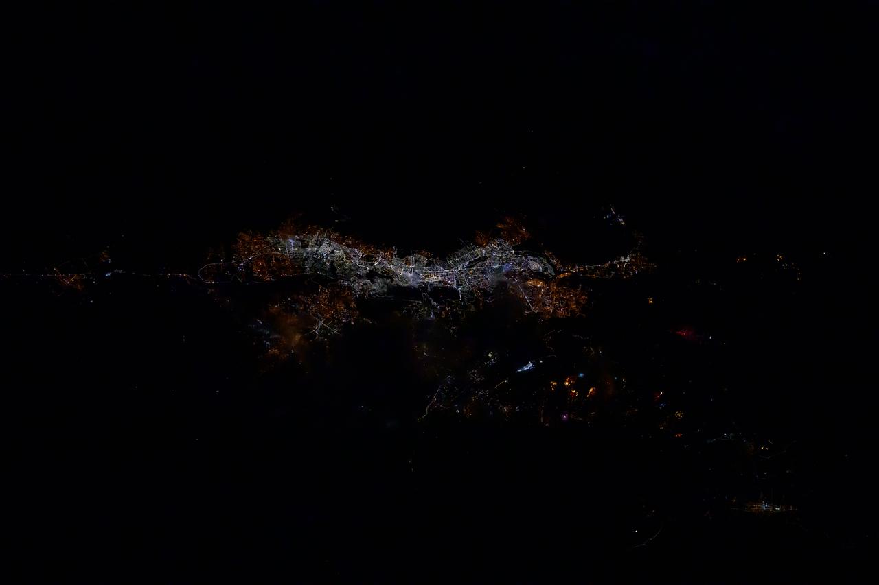
iss072e398817 (Dec. 19, 2024) --- The city lights of Quito, Ecuador, the South American nation's capital and second largest city located in the Andes, are pictured at approximately 2:24 a.m. local time from the International Space Station as it orbited 255 miles above.
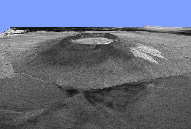
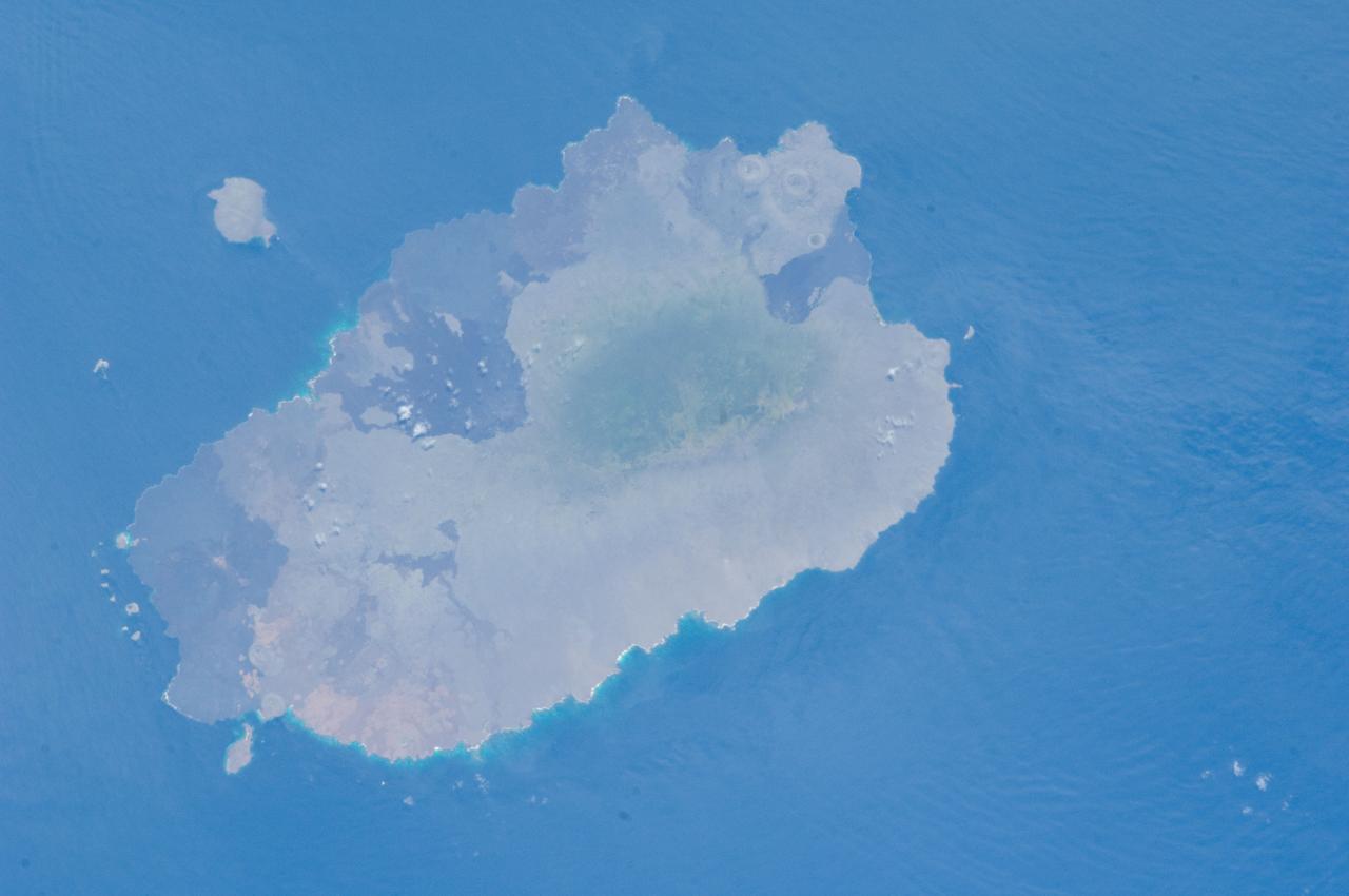
This is a three-dimensional view of Isabela, one of the Galapagos Islands located off the western coast of Ecuador, South America.
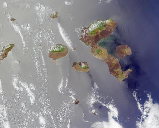
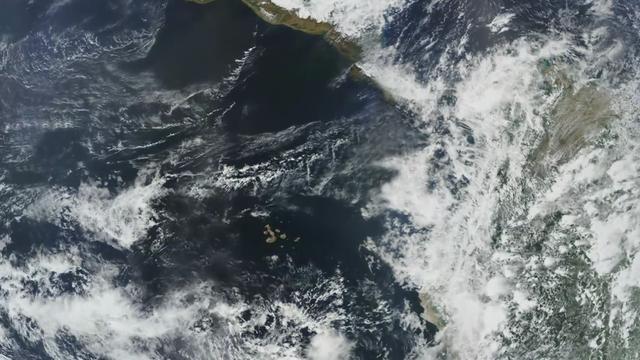
The Galapagos, situated in the Pacific Ocean roughly 1000 kilometers west of mainland Ecuador. This image from NASA Terra satellite is MISR Mystery Image Quiz #4.
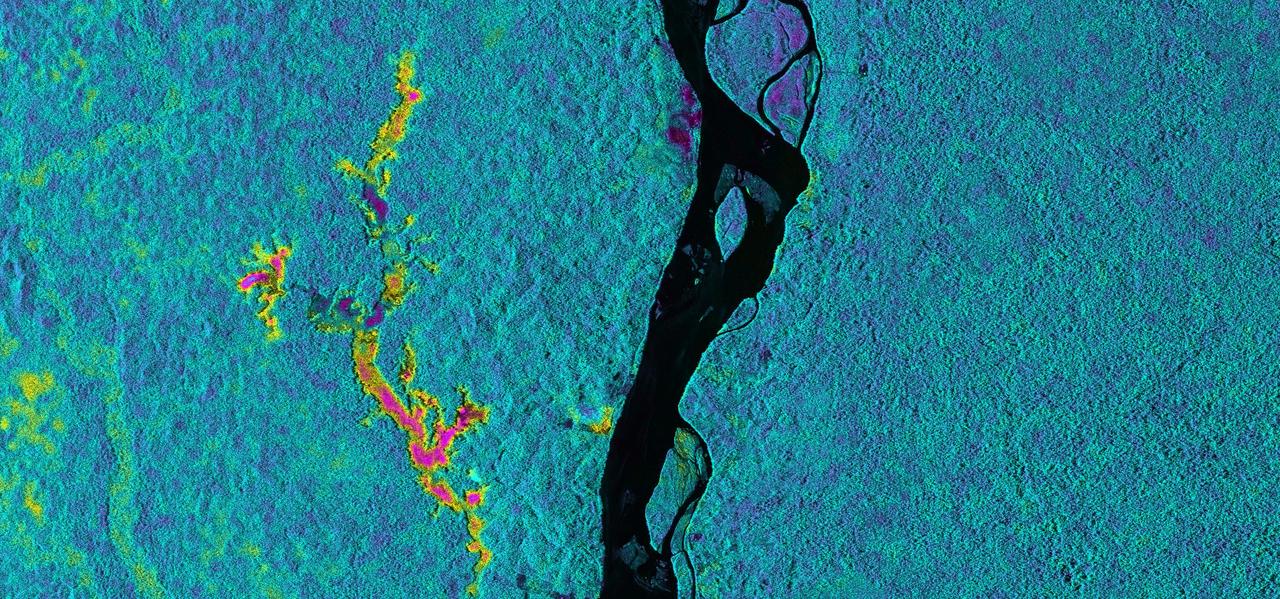
On March 17, 2013, NASA Uninhabited Aerial Vehicle Synthetic Aperture Radar UAVSAR acquired synthetic aperture radar data over the Napo River in Ecuador and Peru.
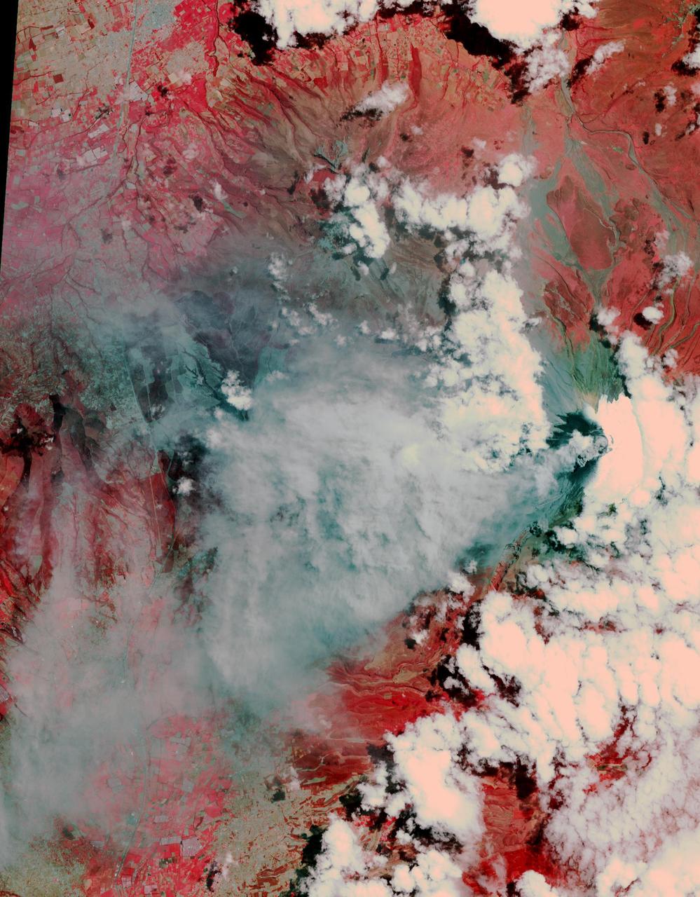
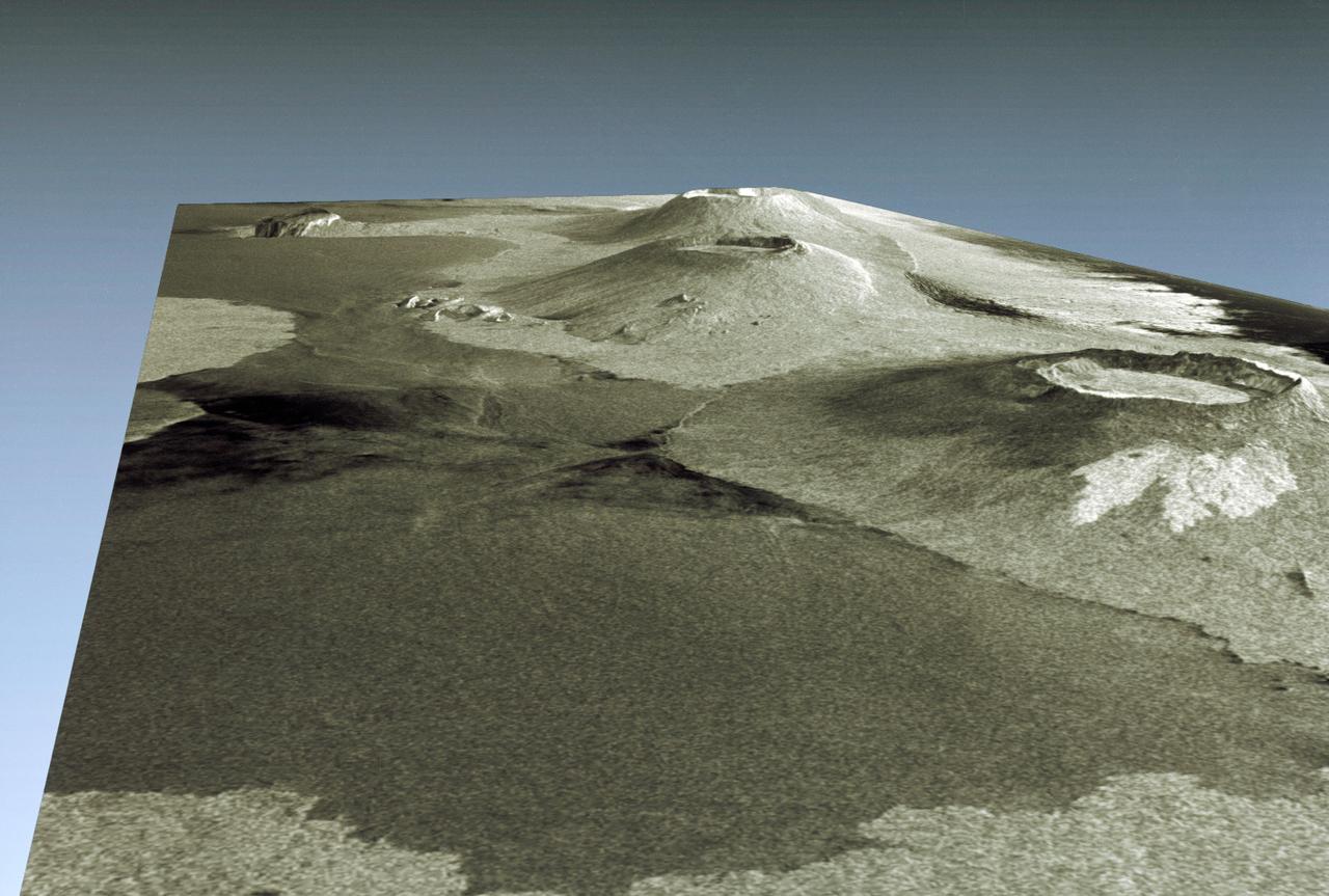
After lying dormant for 70 years, Cotopaxi volcano in Ecuador started erupting the week of Aug. 17, 2015. NASA Terra spacecraft acquired this image on August 22, showing huge columns of ash that affected towns in the region.
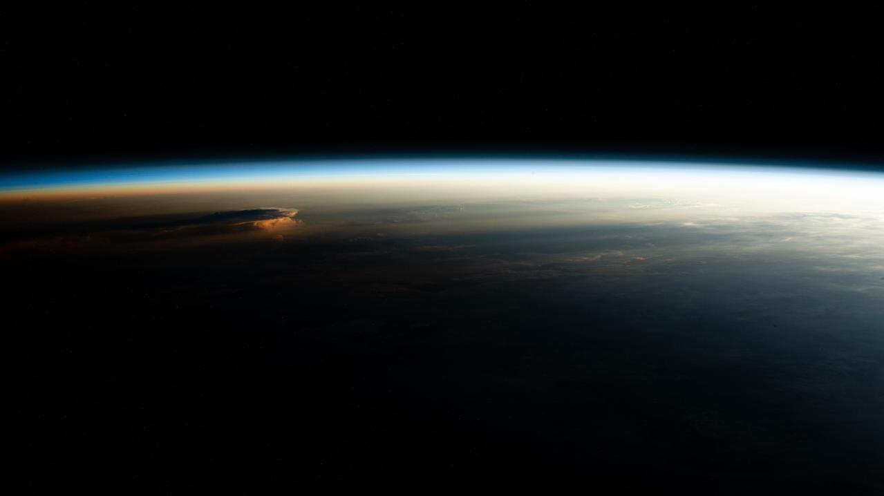
iss070e003364 (Oct. 13, 2023) --- An orbital sunrise casts elongated cloud shadows in this photograph from the International Space Station as it orbited 260 miles above the Peru-Ecuador border in South America.
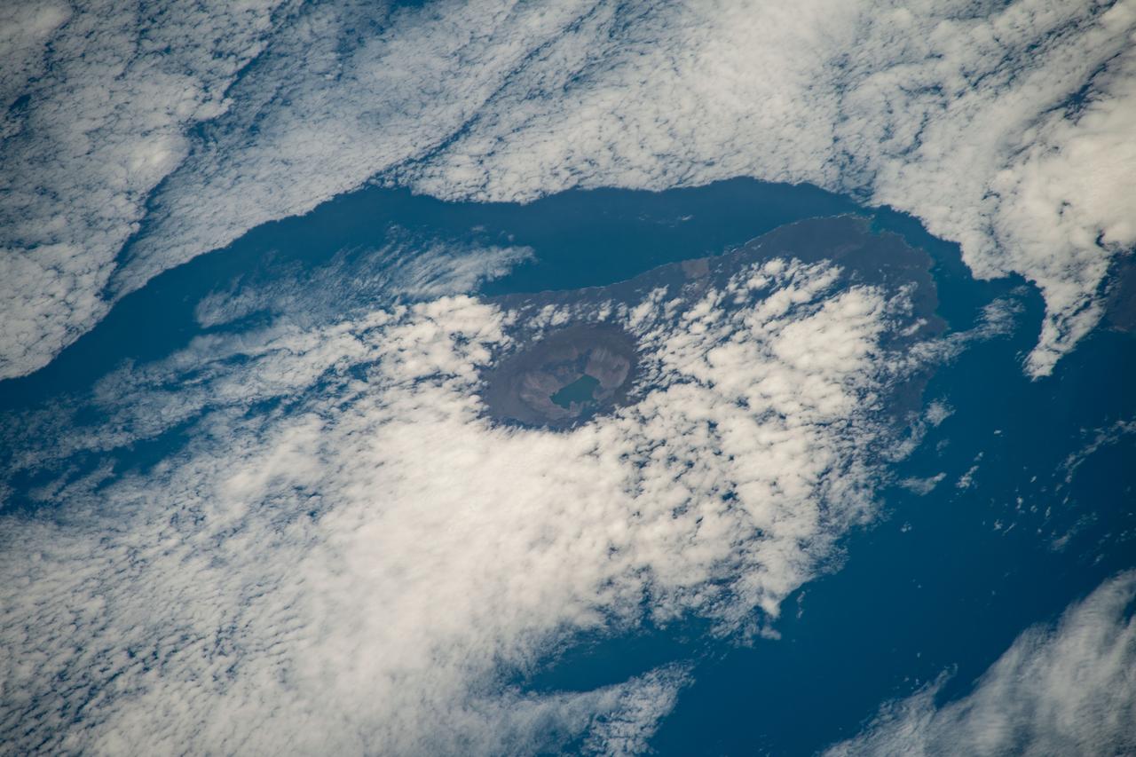
iss068e025397 (Nov. 28, 2022) --- The peak of La Cumbre Volcano on Ecuador's Fernandina Island, part of the Galapagos Islands, is surrounded by clouds in this photograph from the International Space Station as it orbited 261 miles above the Pacific Ocean.
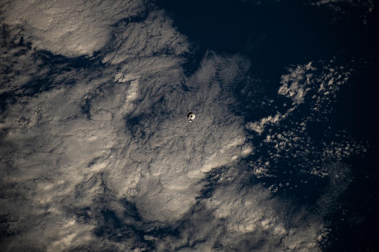
iss072e145206 (Nov. 5, 2024) --- The SpaceX Dragon cargo spacecraft is pictured approaching the International Space Station as both spacecraft were orbiting 255 miles above a cloudy Pacific Ocean southwest of Ecuador's Galápagos Islands.
iss055e023500 (April 13, 2018) --- The cloud-covered Galapagos Islands and the sun's glint in the waters off the coast of Ecuador are pictured as the International Space Station orbited above the Pacific Ocean.
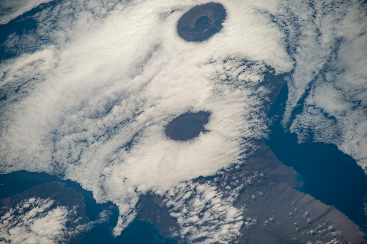
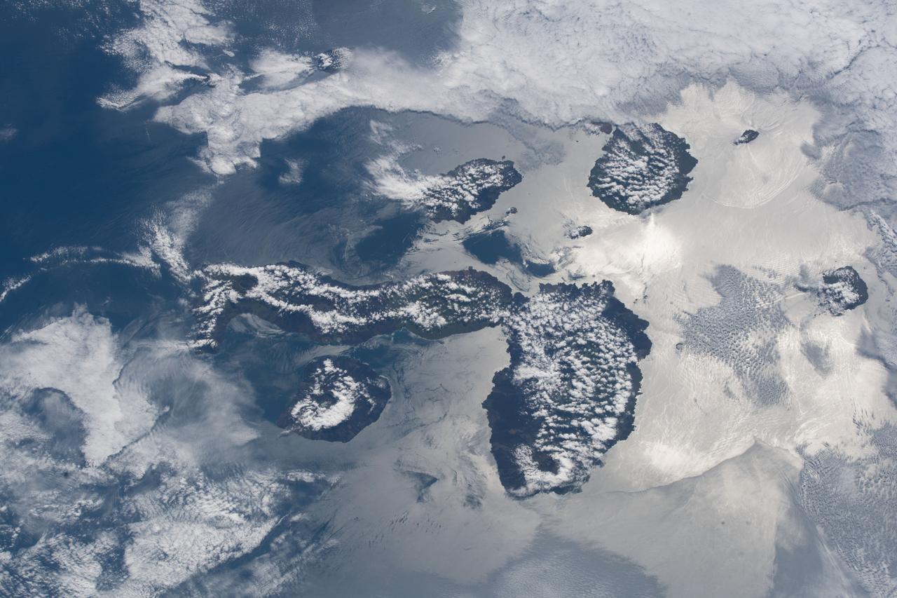
iss068e025399 (Nov. 28, 2022) --- From top, the peaks of Wolf Volcano and Darwin Volcano on Ecuador's Isabel Island, part of the Galapagos Islands, are surrounded by clouds in this photograph from the International Space Station as it orbited 261 miles above the Pacific Ocean.
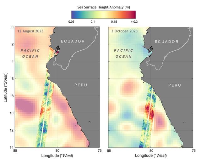
The illustration above shows sea levels off the coasts of Peru and Ecuador on Aug. 12, 2023, and Oct. 3, 2023. The Surface Water and Ocean Topography (SWOT) satellite collected the ocean data during its operational phase, which began in late July. The red and orange colors represent sea levels that are higher than average (units are in meters), while green and blue indicate sea levels that are lower than average. The SWOT data shows some of the development of an El Niño along the west coast of the Americas. The SWOT science team made the measurements using the spacecraft's Ka-band Radar Interferometer (KaRIn) instrument. With two antennas spread 33 feet (10 meters) apart on a boom, KaRIn produces a pair of data swaths (tracks visible in the animation) as it circles the globe, bouncing radar pulses off the water's surface to collect surface-height measurements. Launched on Dec. 16, 2022, from Vandenberg Space Force Base in central California, SWOT is now in its operations phase, measuring the height of nearly all water on Earth's surface. The satellite will provide one of the most detailed, comprehensive views yet of the planet's oceans and fresh water lakes and rivers, collecting data that will be used for research and other purposes. https://photojournal.jpl.nasa.gov/catalog/PIA26181
Completed: 07-16-2009 Straddling the equator approximately 1000 kilometers to the west of the South American mainland, the Galapagos Islands lie within the heart of the equatorial current system. Rising from the sea floor, the volcanic islands of the Galapagos are set on top of a large submarine platform. The main portion of the Galapagos platform is relatively flat and less than 1000 meters in depth. The steepest slopes are found along the western and southern flanks of the platform with a gradual slope towards the east. The interactions of the Galapagos and the oceanic currents create vastly different environmental regimes which not only isolates one part of the Archipelago from the other but allows penguins to live along the equator on the western part of the Archipelago and tropical corals around the islands to the north. The islands are relatively new in geologic terms with the youngest islands in the west still exhibiting periodic eruptions from their massive volcanic craters. Please give credit for this item to: NASA/Goddard Space Flight Center, The SeaWiFS Project and GeoEye, Scientific Visualization Studio. NOTE: All SeaWiFS images and data presented on this web site are for research and educational use only. All commercial use of SeaWiFS data must be coordinated with GeoEye (http://www.geoeye.com). To download this video go to: <a href="http://svs.gsfc.nasa.gov/goto?3628" rel="nofollow">svs.gsfc.nasa.gov/goto?3628</a> <b><a href="http://www.nasa.gov/centers/goddard/home/index.html" rel="nofollow">NASA Goddard Space Flight Center</a></b> is home to the nation's largest organization of combined scientists, engineers and technologists that build spacecraft, instruments and new technology to study the Earth, the sun, our solar system, and the universe.
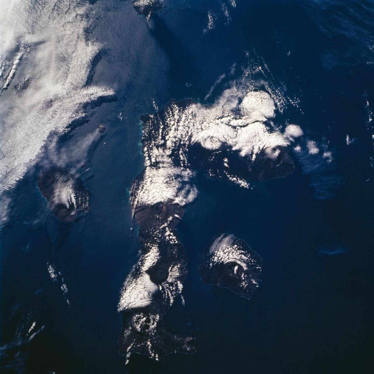
STS072-732-072 (11-20 Jan. 1996) --- Three of the nineteen Galapagos Islands are visible in this image, photographed from the Earth-orbiting Space Shuttle Endeavour. The Galapagos Islands are located 600 miles (1,000 kilometers) to the west of Ecuador. The largest of the islands, Isabela, is at center (north is toward the upper right corner). The numerous circular features on the island, highlighted by clouds, are volcanoes. The Galapagos Islands owe their existence to a hot spot, or persistent heat source in the mantle, which also is located over a rift, or place where plates are separating and new crust is being created. The rift is located between the Cocos and Nazca Plates. The dark linear features on the islands are lava flows from past eruptions. The island to the left of Isabela is Fernandina, while the island to the right is San Salvador. The Galapagos Islands were visited by the English naturalist Charles Darwin in 1835.
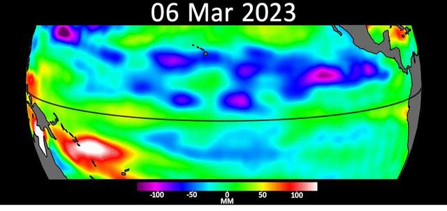
Sea level data from the U.S.-European satellite Sentinel-6 Michael Freilich shows early signs of a developing El Niño along the equatorial Pacific Ocean. The measurements show Kelvin waves, low waves that can be tens of miles (hundreds of kilometers) wide, moving from west to east at the equator towards the west coast of Ecuador. When they form at the equator, Kelvin waves can move warm water – associated with higher sea levels – from the western Pacific to the eastern Pacific. El Niño is a periodic climate phenomenon that can affect weather patterns around the world. The condition can bring cooler, wetter conditions to the U.S. Southwest and drought to countries in the western Pacific such as Indonesia and Australia. El Niño is characterized by higher sea levels and warmer-than-average ocean temperatures along the western coasts of North and South America. Water expands as it warms, so sea levels tend to be higher in places with warmer water. The climate phenomenon is also associated with a weakening of the trade winds. The Sentinel-6 Michael Freilich satellite data shown here covers a seven-week period between the beginning of March and the end of April 2023. By April 24, Figure A, Kelvin waves had piled up warmer water and higher sea levels (shown in red and white) off the coasts of Peru, Ecuador, and Columbia. A series of Kelvin waves starting in spring is a well-known precursor to an El Niño. The waves seen during March and April 2023 are similar to the ones that preceded the 1997-1998 El Niño, one of the most powerful in recorded history. Satellites like Sentinel-6 Michael Freilich can detect Kelvin waves with an instrument called an altimeter that uses radar signals to measure the height of the ocean's surface. Warmer areas show up as higher sea levels. The satellite, named after former NASA Earth Science Division Director Michael Freilich, is one of two that compose the Copernicus Sentinel-6/Jason-CS (Continuity of Service) mission. Animation available at https://photojournal.jpl.nasa.gov/catalog/PIA25776
This is a radar image of a little known volcano in northern Colombia. The image was acquired on orbit 80 of space shuttle Endeavour on April 14, 1994, by NASA Spaceborne Imaging Radar C/X-Band Synthetic Aperture Radar SIR-C/X-SAR. The volcano near the center of the image is located at 5.6 degrees north latitude, 75.0 degrees west longitude, about 100 kilometers (65 miles) southeast of Medellin, Colombia. The conspicuous dark spot is a lake at the bottom of an approximately 3-kilometer-wide (1.9-mile) volcanic collapse depression or caldera. A cone-shaped peak on the bottom left (northeast rim) of the caldera appears to have been the source for a flow of material into the caldera. This is the northern-most known volcano in South America and because of its youthful appearance, should be considered dormant rather than extinct. The volcano's existence confirms a fracture zone proposed in 1985 as the northern boundary of volcanism in the Andes. The SIR-C/X-SAR image reveals another, older caldera further south in Colombia, along another proposed fracture zone. Although relatively conspicuous, these volcanoes have escaped widespread recognition because of frequent cloud cover that hinders remote sensing imaging in visible wavelengths. Four separate volcanoes in the Northern Andes nations of Colombia and Ecuador have been active during the last 10 years, killing more than 25,000 people, including scientists who were monitoring the volcanic activity. Detection and monitoring of volcanoes from space provides a safe way to investigate volcanism. The recognition of previously unknown volcanoes is important for hazard evaluations because a number of major eruptions this century have occurred at mountains that were not previously recognized as volcanoes. http://photojournal.jpl.nasa.gov/catalog/PIA01722
STS059-S-085 (18 April 1994) --- This is a three-dimensional perspective view of part of Isla Isabela in the western Galapagos Islands. It was taken by the L-Band radar in HH polarization from the Spaceborne Imaging Radar-C and X-Band Synthetic Aperture Radar (SIR-C/X-SAR) on the 40th orbit of the Space Shuttle Endeavour. This view was constructed by overlaying a SIR-C radar image on a U.S. Geological Survey digital elevation map. The image is centered at about .5 degrees south latitude and 91 degrees west longitude, and covers an area of 75 by 60 kilometers. The radar incidence angle at the center of the image is about 20 degrees. The western Galapagos Islands, which lie about 1200 kilometers west of Ecuador in the eastern Pacific, have six active volcanoes similar to the volcanoes found in Hawaii. Since the time of Charles Darwin's visit to the area in 1835, there have been over 60 recorded eruptions on these volcanoes. This SIR-C/X-SAR image of Alcedo and Sierra Negra volcanoes shows the rougher lava flows as bright features, while ash deposits and smooth pahoehoe lava flows appear dark. The Galapagos Islands are one of the SIR-C/X-SAR supersites and data of this area will be taken several times during the flight to allow scientists to conduct topographic change studies and to search for different lava flow types, ash deposits and fault lines. SIR-C/X-SAR is part of NASA's Mission to Planet Earth (MTPE). SIR-C/X-SAR radars illuminate Earth with microwaves allowing detailed observations at any time, regardless of weather or sunlight conditions. SIR-C/X-SAR uses three microwave wavelengths: L-Band (24 cm), C-Band (6 cm), and X-Band (3 cm). The multi-frequency data will be used by the international scientific community to better understand the global environment and how it is changing. The SIR-C/X-SAR data, complemented by aircraft and ground studies, will give scientists clearer insights into those environmental changes which are caused by nature and those changes which are induced by human activity. SIR-C was developed by NASA's Jet Propulsion Laboratory (JPL). X-SAR was developed by the Dornire and Alenia Spazio Companies for the German Space Agency, Deutsche Agentur fuer Raumfahrtangelegenheiten (DARA), and the Italian Space Agency, Agenzia Spaziale Italiana (ASI). JPL Photo ID: P-43938
ISS033-E-012648 (18 Oct. 2012) --- Isla Santiago is featured in this image photographed by an Expedition 33 crew member on the International Space Station. The island of Santiago is located near the center of the Galapagos Islands off the coast of Ecuador. The Galapagos Islands are situated near the equator, and were formed from volcanism related to a large mantle plume (also known as a hot spot). This hot spot is very close to the tectonic boundary between the Galapagos Ridge, a plate boundary that is also an oceanic spreading center, and the Nazca and Cocos plates. This combination of mantle plumes and tectonic plate movements produces a unique geological environment, including underwater ridges of volcanoes that influence the water circulation around the Galapagos. All of these aspects contribute to the geology and biology of the Galapagos. Isla Santiago itself is formed from a shield volcano also called Santiago. This type of volcanic structure is recognized by low, flat summits surrounded by extensive flow fields of lava; the lava is not very viscous, so it can flow for great distances from the source vents. Several dark lava flow fields are visible in this photograph, the largest along the eastern, western, and southern coastlines. The small Isla Rabida to the south of Isla Santiago is the peak of another, mostly submerged shield volcano. In addition to the lava flows, other volcanic features known as tuff cones are visible on the eastern and western sides of the island. These cones are formed from the rapid interaction of hot flowing lava and water. The water underneath the lava flow flashes to steam explosively, and this both fragments the lava and rapidly cools it, leading to the formation of cones of glassy, relatively fine-grained volcanic material. The most recent volcanic activity on Isla Santiago occurred during 1904 – 1906. The summit ridge of the Santiago shield volcano is located in the northwestern part of the island (center). Also at center is a large but isolated region of green vegetation primarily located on the south-facing slope below the summit ridge. This image was taken during the dry, or garua, season that lasts from June to November. The season is dominated by cooler air transported by the Southeast Trade winds and cooler waters from the Humboldt and Cromwell currents. The combination of cool air and water results in rain falling only in the island highlands, with south- and east-facing slopes receiving the most precipitation. Despite the favorable topographic location, the yellow green color of the vegetation may indicate water (or other) stress.
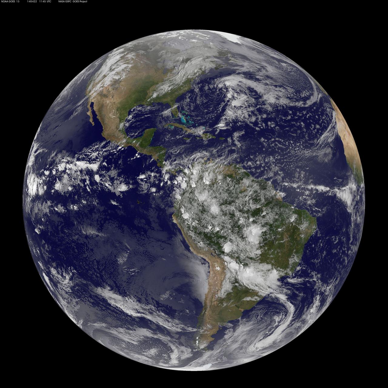
Today, April 22, 2014 is Earth Day, and what better way to celebrate than taking a look at our home planet from space. NOAA's GOES-East satellite captured this stunning view of the Americas on Earth Day, April 22, 2014 at 11:45 UTC/7:45 a.m. EDT. The data from GOES-East was made into an image by the NASA/NOAA GOES Project at NASA's Goddard Space Flight Center in Greenbelt, Md. In North America, clouds associated with a cold front stretch from Montreal, Canada, south through the Tennessee Valley, and southwest to southern Texas bringing rain east of the front today. A low pressure area in the Pacific Northwest is expected to bring rainfall in Oregon, Washington, Idaho, stretching into the upper Midwest, according to NOAA's National Weather Service. That low is also expected to bring precipitation north into the provinces of British Columbia and Alberta, Canada. Another Pacific low is moving over southern Nevada and the National Weather Service expects rain from that system to fall in central California, Nevada, and northern Utah. Near the equator, GOES imagery shows a line of pop up thunderstorms. Those thunderstorms are associated with the Intertropical Convergence Zone (ITCZ). The ITCZ encircles the Earth near the equator. In South America, convective (rapidly rising air that condenses and forms clouds) thunderstorms pepper Colombia, Venezuela, Ecuador, Peru, Bolivia, Paraguay and northwestern and southeastern Brazil. GOES satellites provide the kind of continuous monitoring necessary for intensive data analysis. Geostationary describes an orbit in which a satellite is always in the same position with respect to the rotating Earth. This allows GOES to hover continuously over one position on Earth's surface, appearing stationary. As a result, GOES provide a constant vigil for the atmospheric "triggers" for severe weather conditions such as tornadoes, flash floods, hail storms and hurricanes. For more information about GOES satellites, visit: <a href="http://www.goes.noaa.gov/" rel="nofollow">www.goes.noaa.gov/</a> or <a href="http://goes.gsfc.nasa.gov/" rel="nofollow">goes.gsfc.nasa.gov/</a> Rob Gutro NASA's Goddard Space Flight Center <b><a href="http://www.nasa.gov/audience/formedia/features/MP_Photo_Guidelines.html" rel="nofollow">NASA image use policy.</a></b> <b><a href="http://www.nasa.gov/centers/goddard/home/index.html" rel="nofollow">NASA Goddard Space Flight Center</a></b> enables NASA’s mission through four scientific endeavors: Earth Science, Heliophysics, Solar System Exploration, and Astrophysics. Goddard plays a leading role in NASA’s accomplishments by contributing compelling scientific knowledge to advance the Agency’s mission. <b>Follow us on <a href="http://twitter.com/NASAGoddardPix" rel="nofollow">Twitter</a></b> <b>Like us on <a href="http://www.facebook.com/pages/Greenbelt-MD/NASA-Goddard/395013845897?ref=tsd" rel="nofollow">Facebook</a></b> <b>Find us on <a href="http://instagram.com/nasagoddard?vm=grid" rel="nofollow">Instagram</a></b>