Elysium Planitia
Elysium Planitia
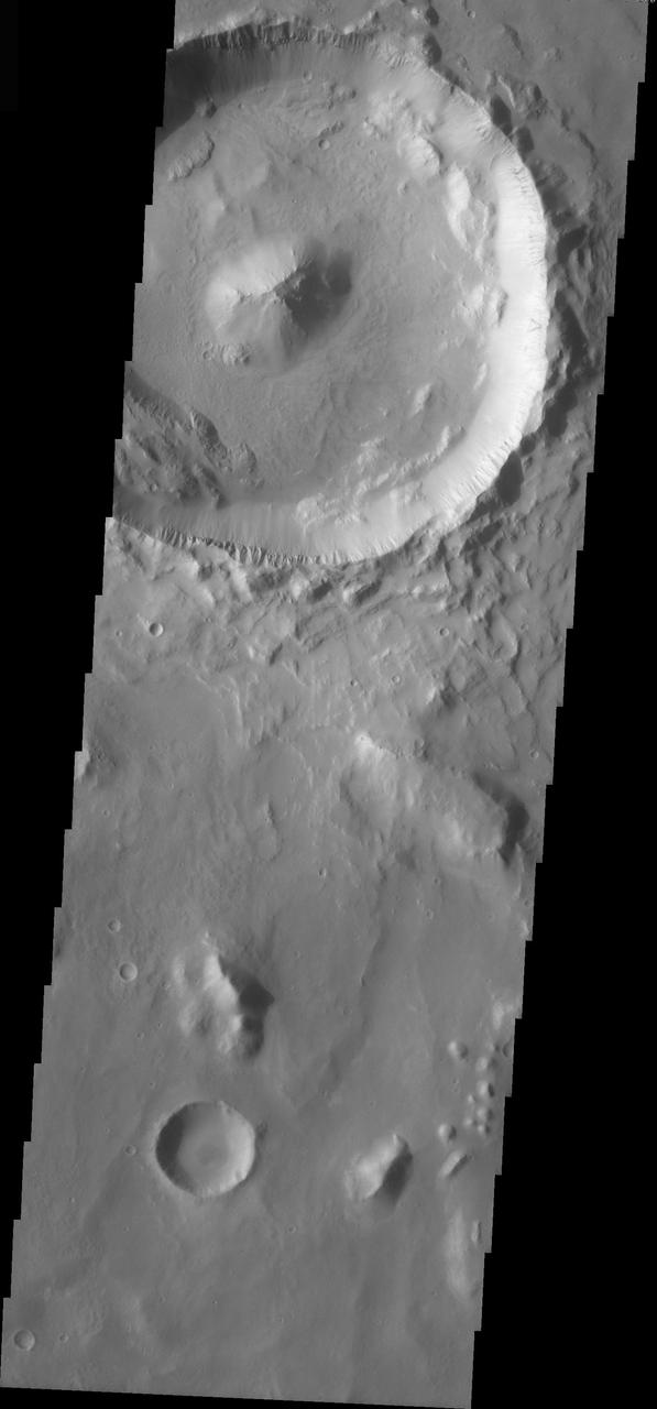
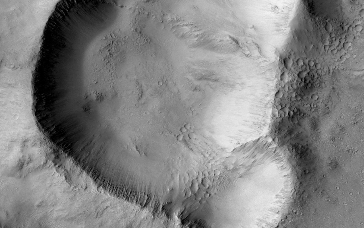
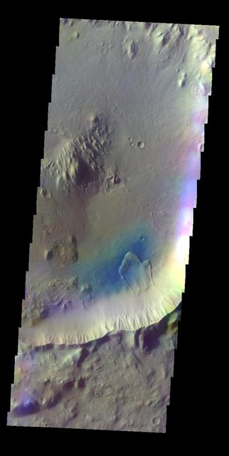
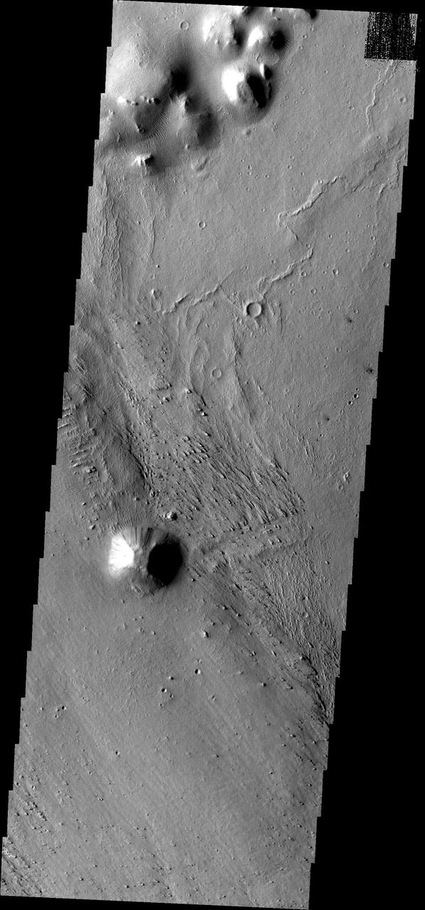
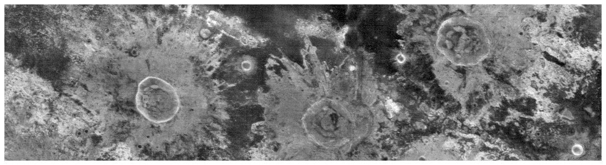
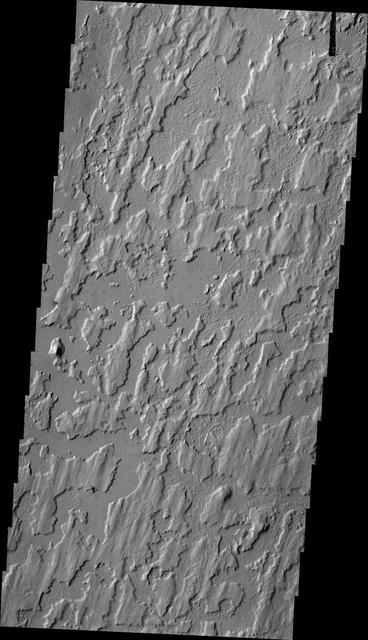
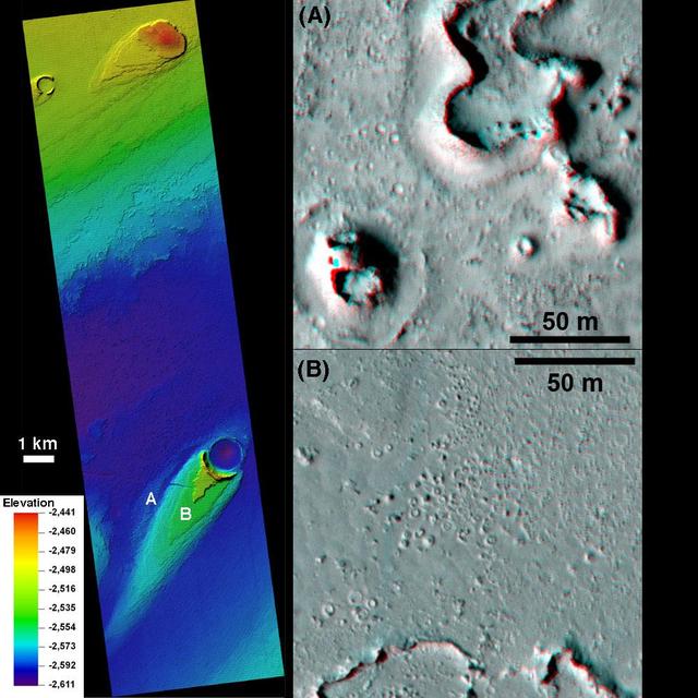
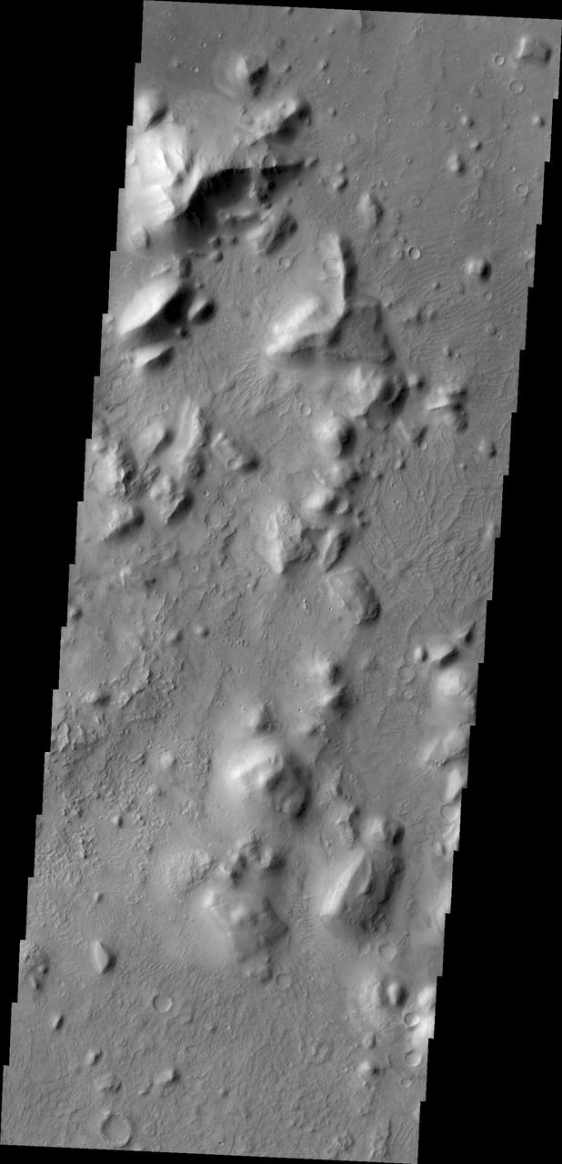
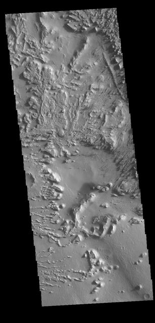
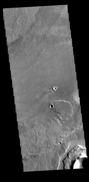
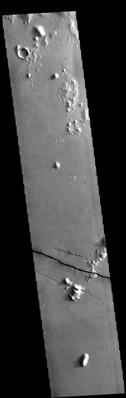
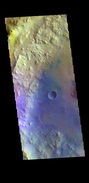
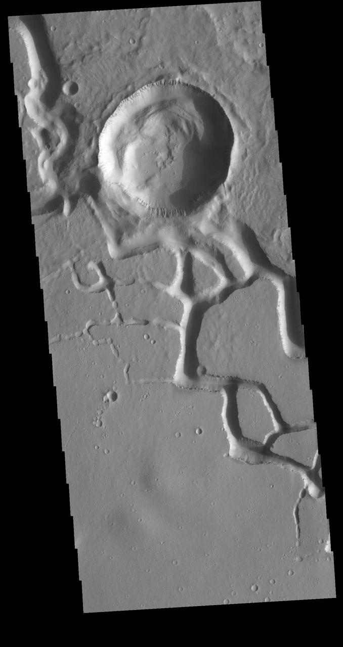
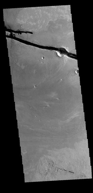
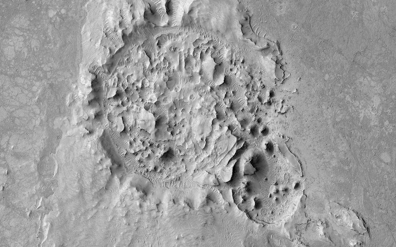
Central Peak in Elysium Planitia
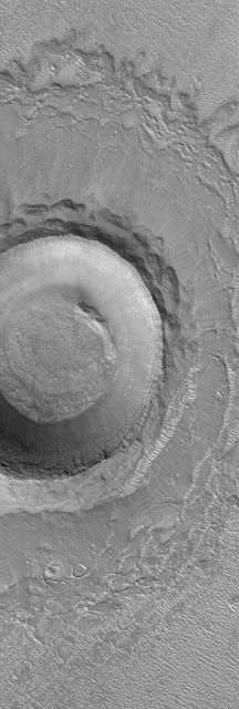
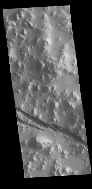
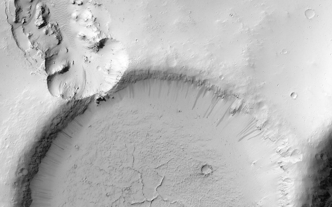
Crater in Elysium Planitia
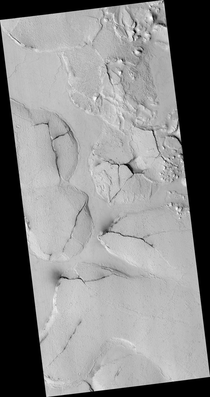
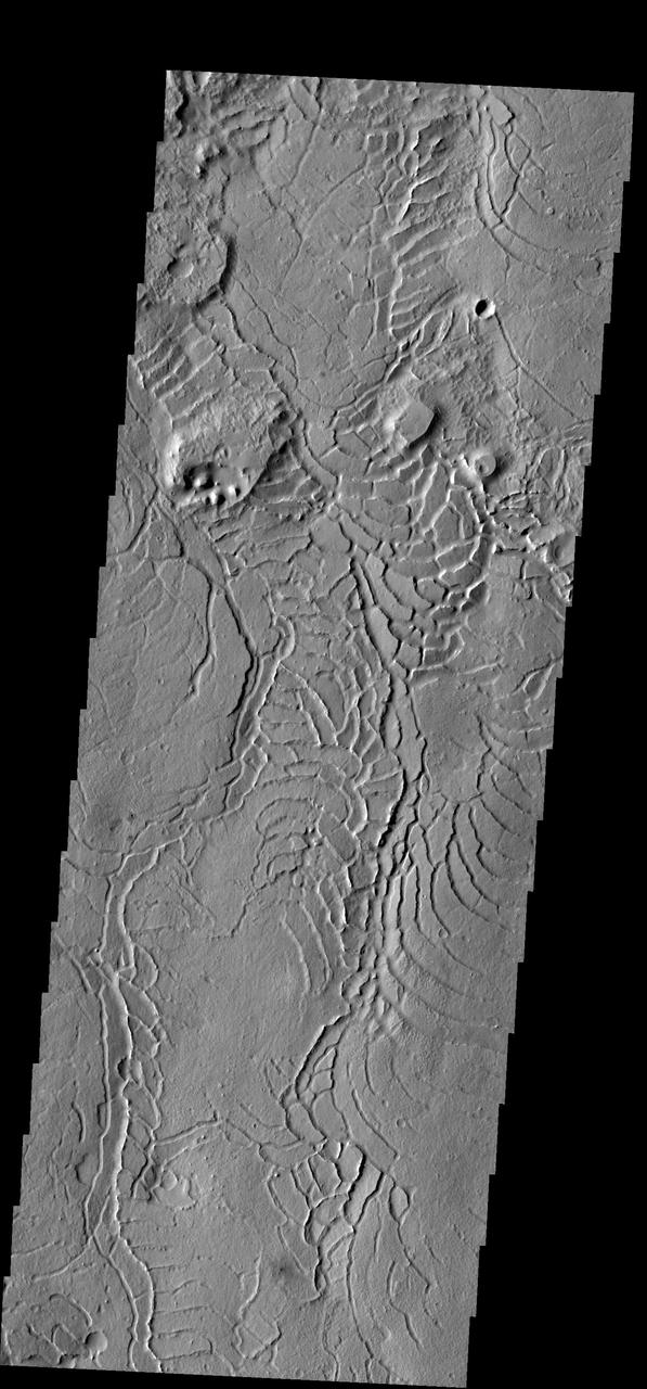
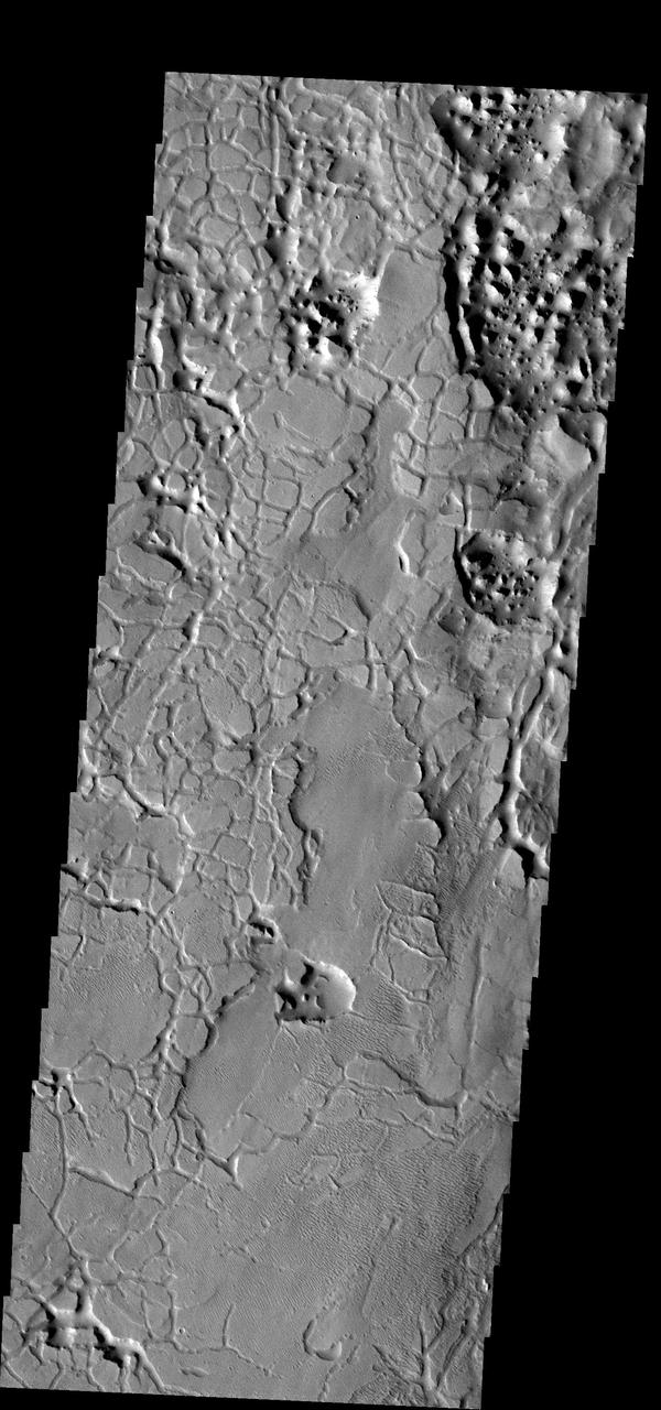
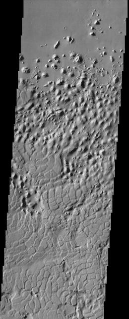
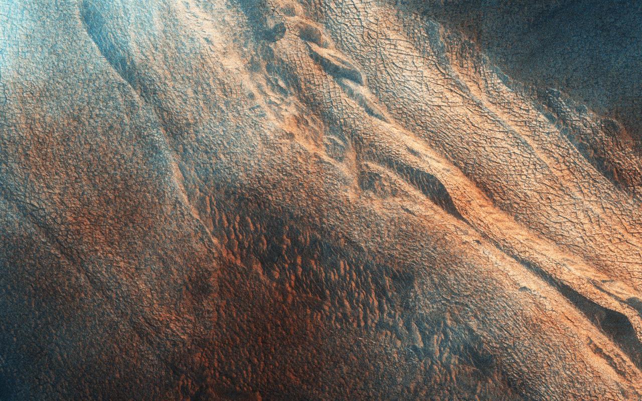
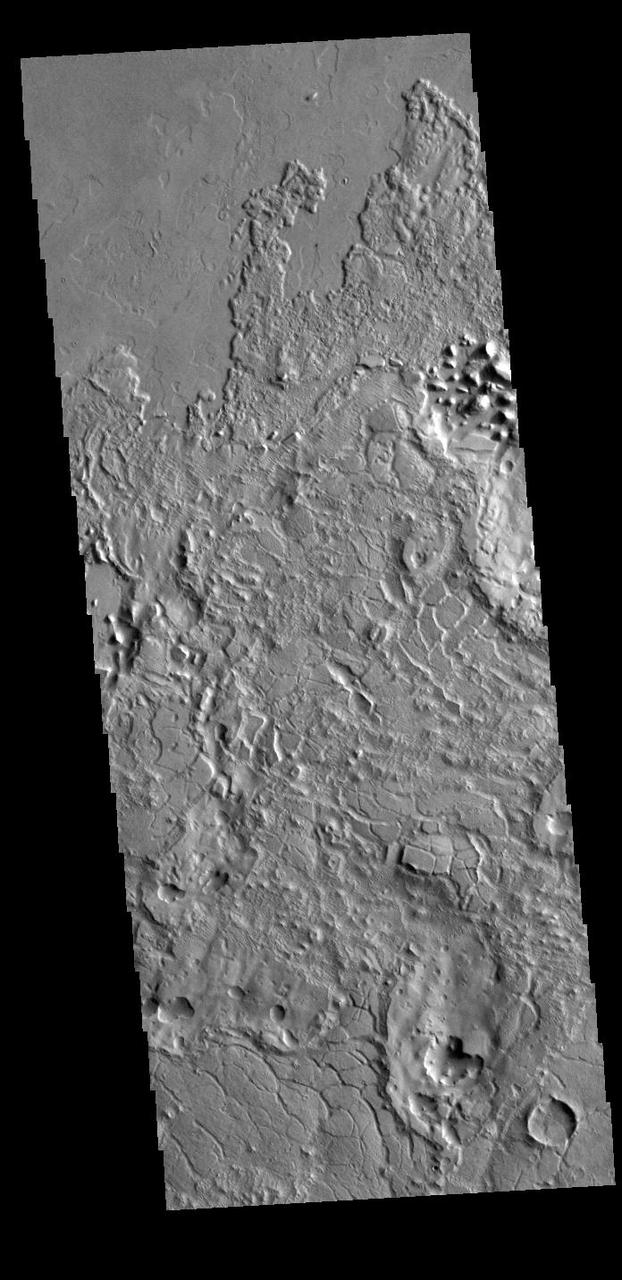
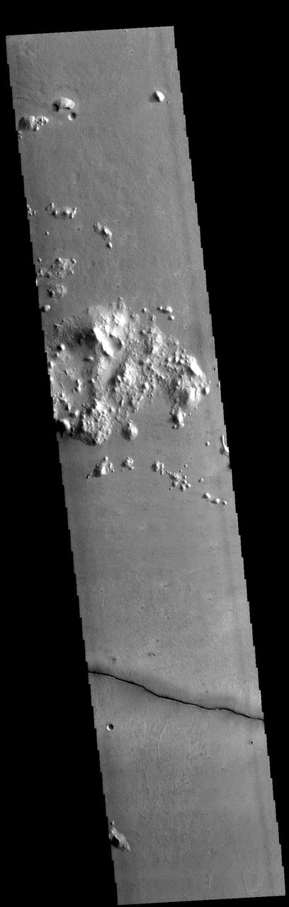
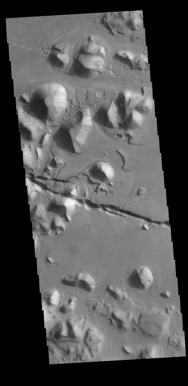
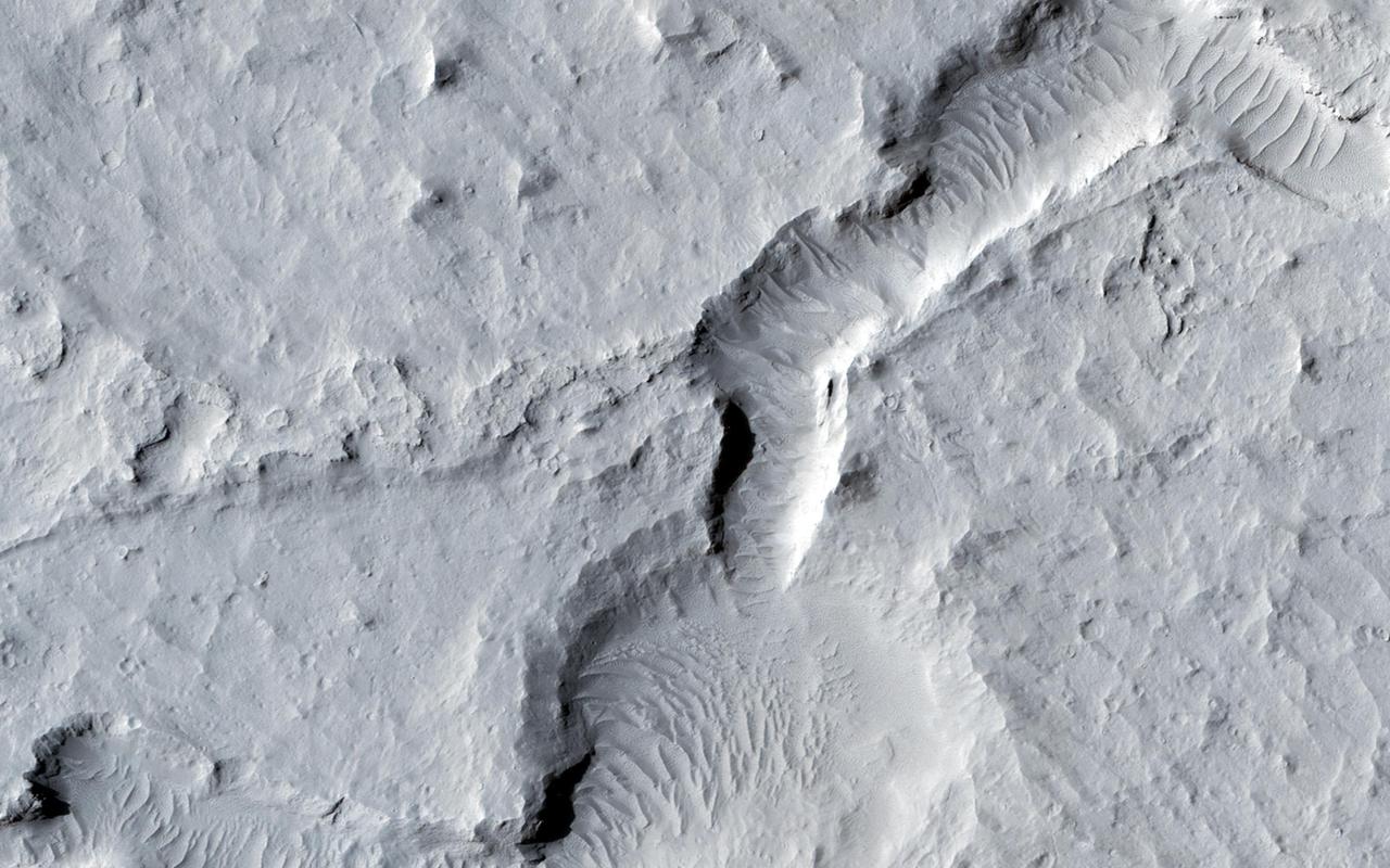
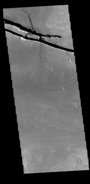
Fractured Mounds in Elysium Planitia
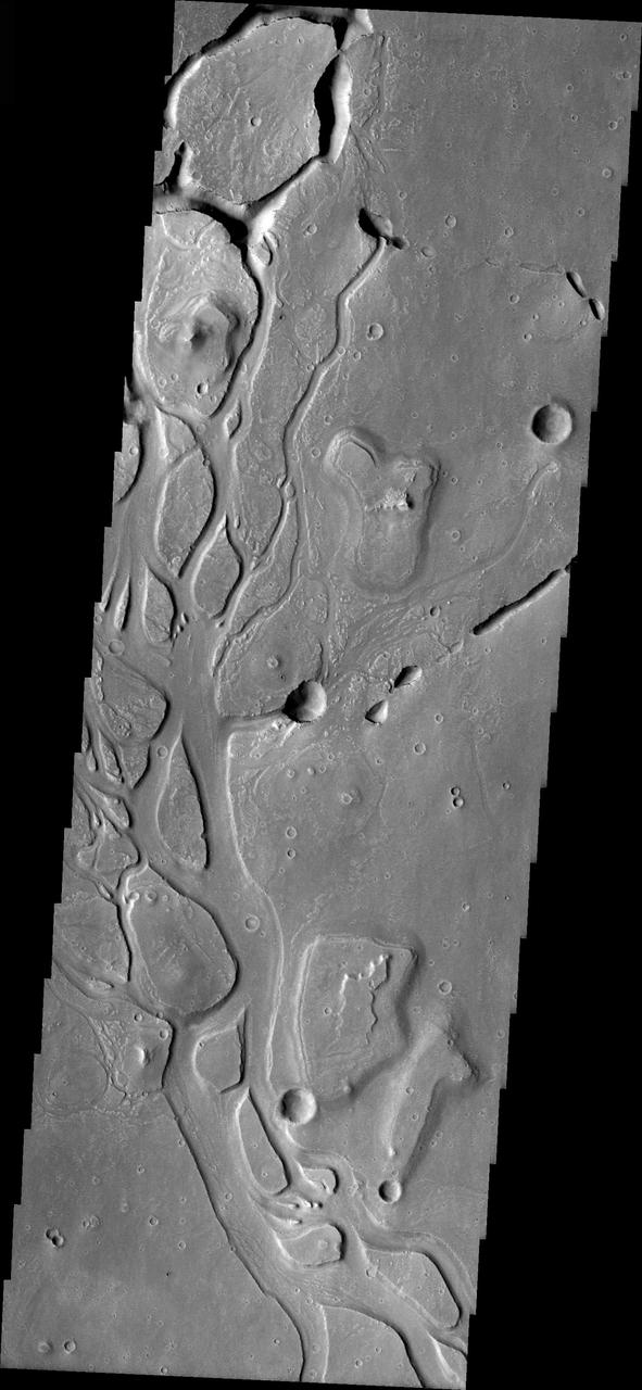
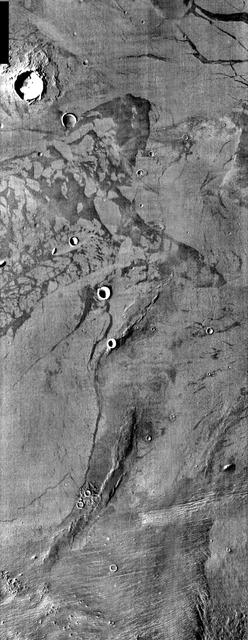
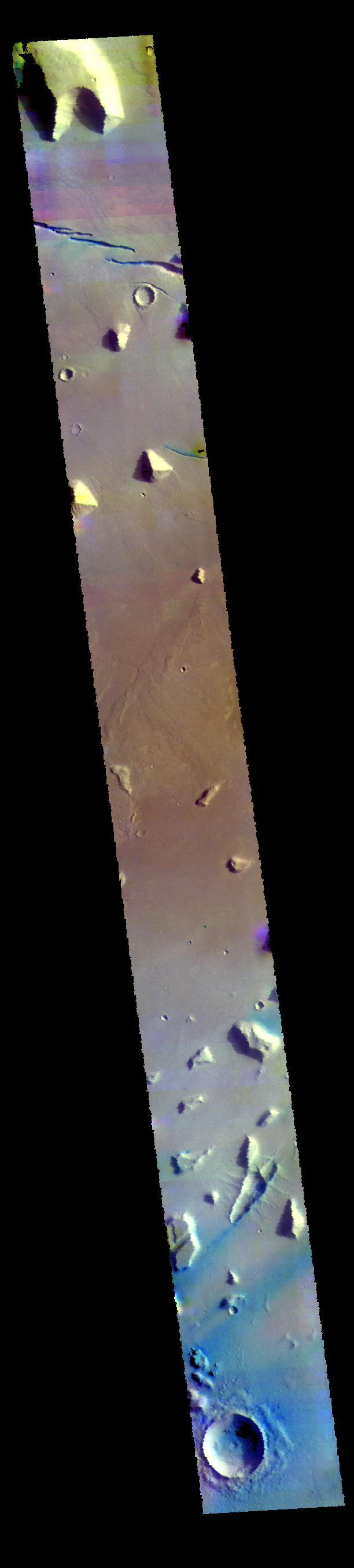
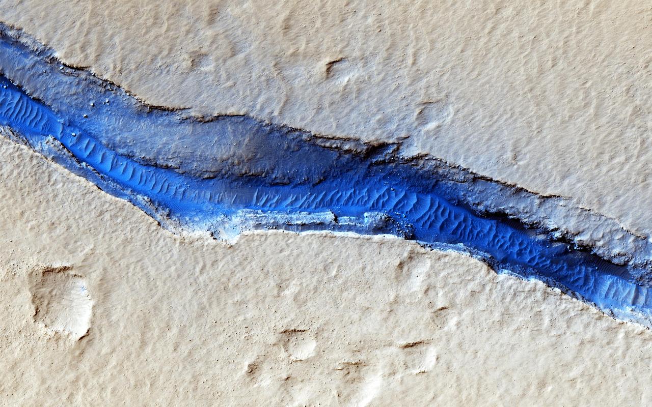
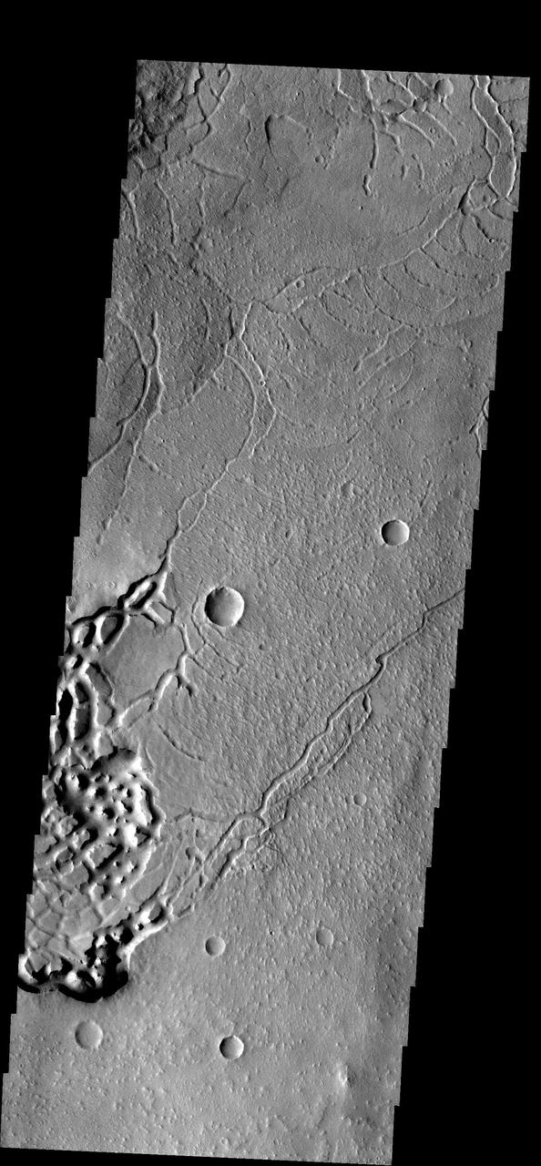
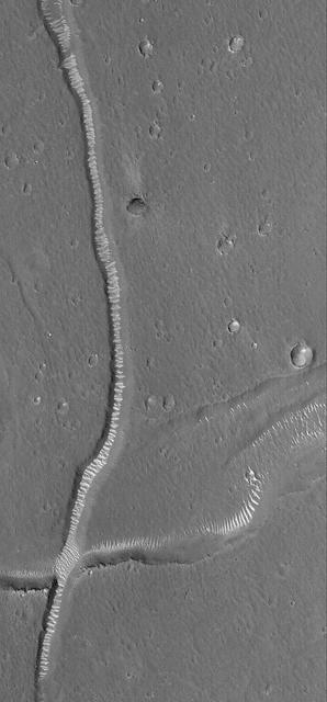
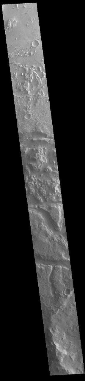
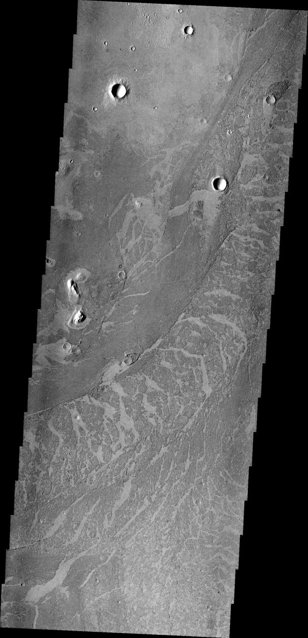
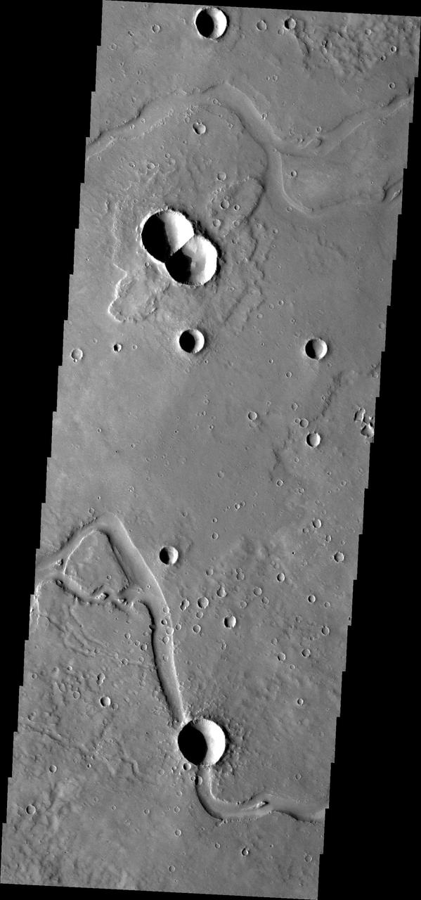
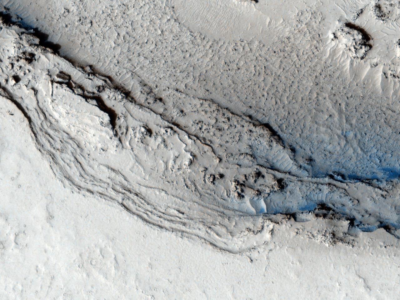
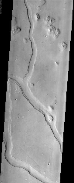
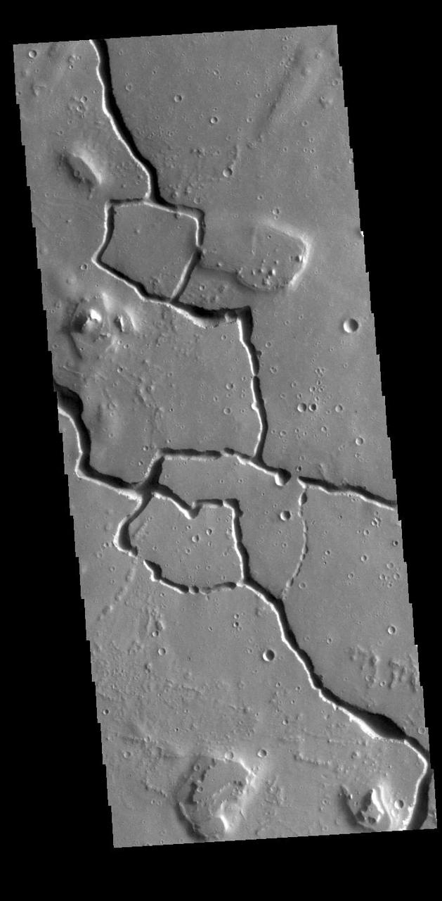
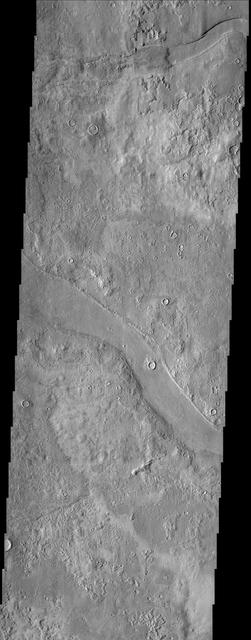
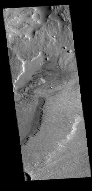
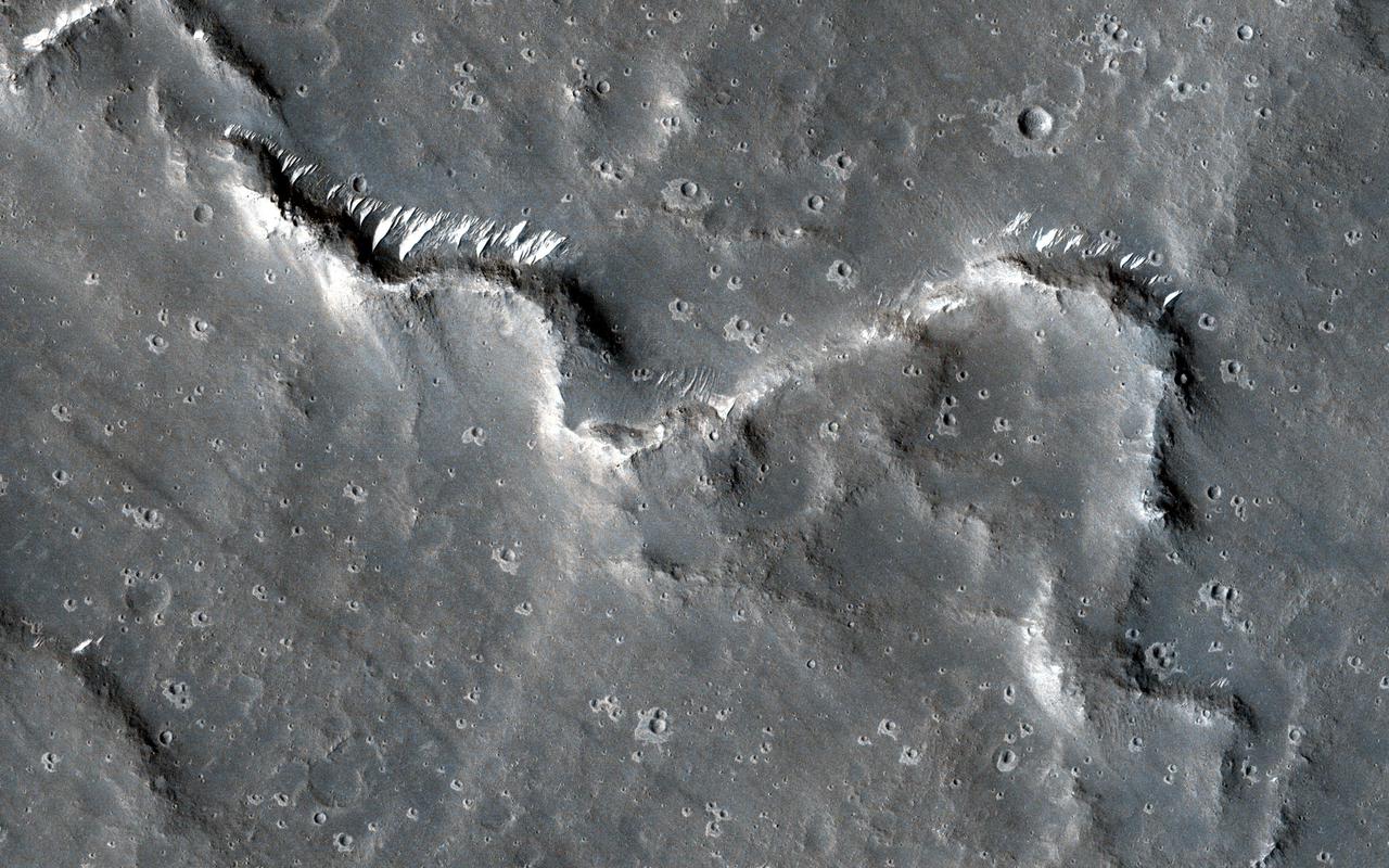
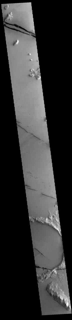
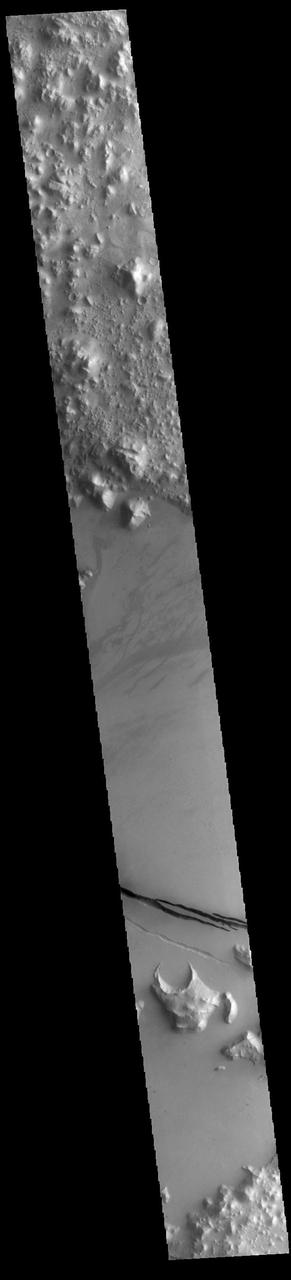
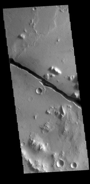
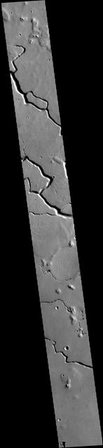
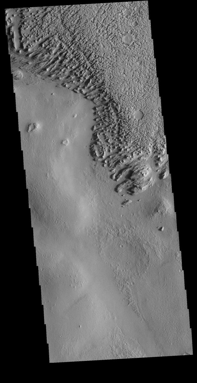
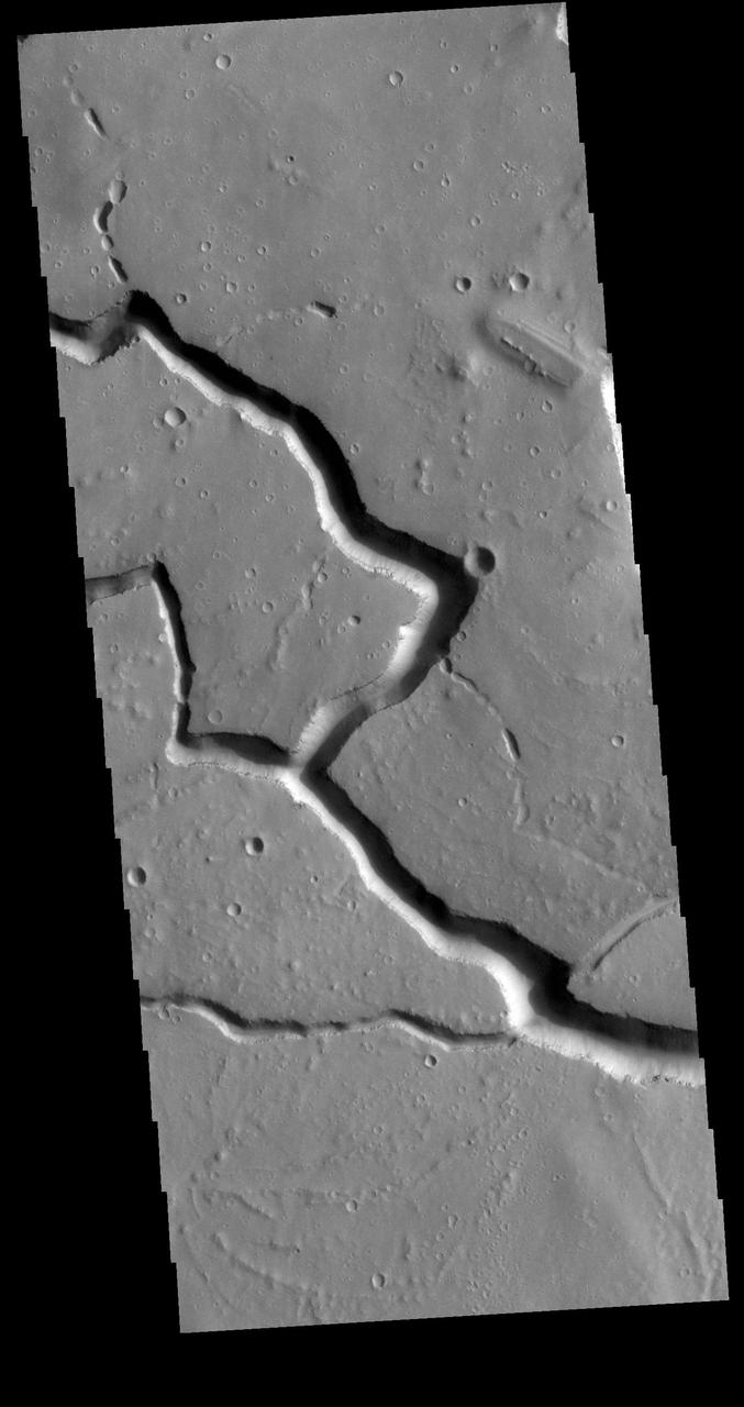
Channels in Elysium Planitia
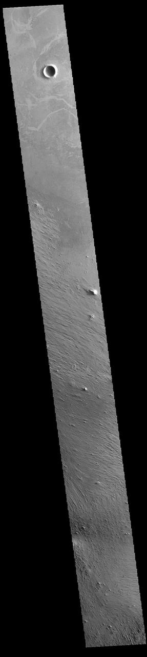
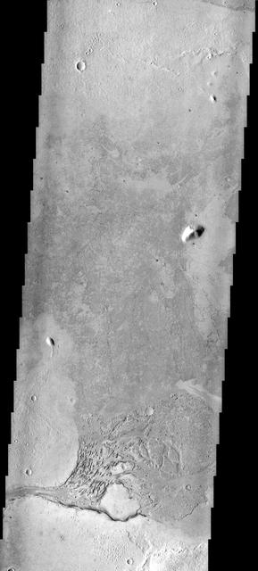
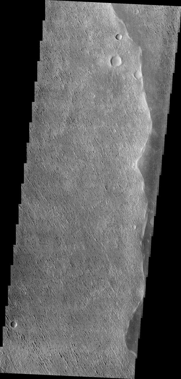
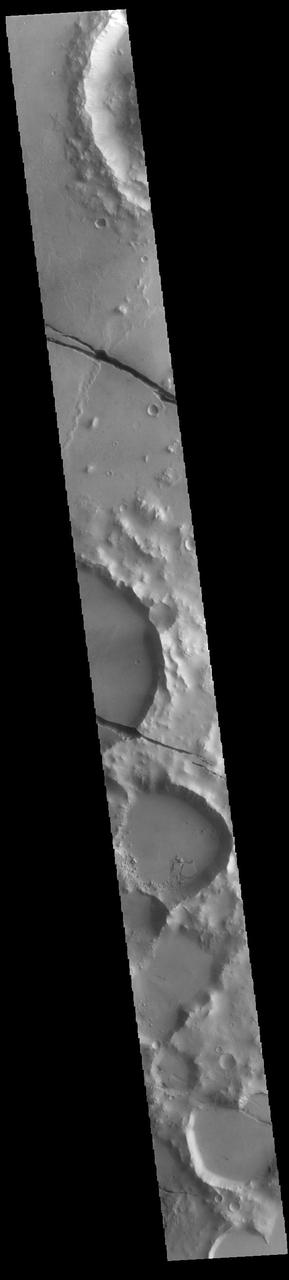
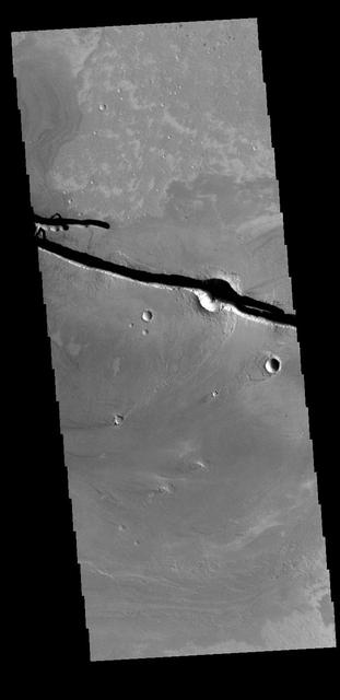
West Elysium Planitia Crater
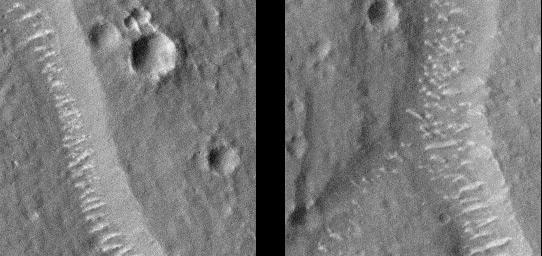
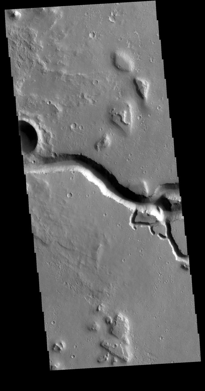
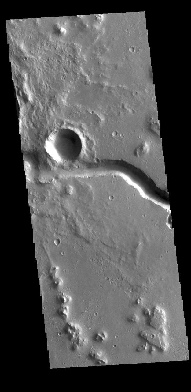
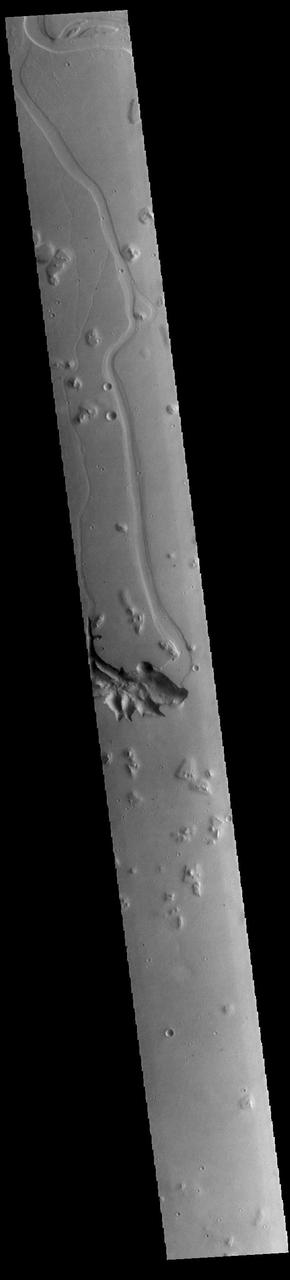
This image from NASA Mars Odyssey shows an unnamed channel located on the margin of Elysium Planitia and the Elysium volcanic complex.
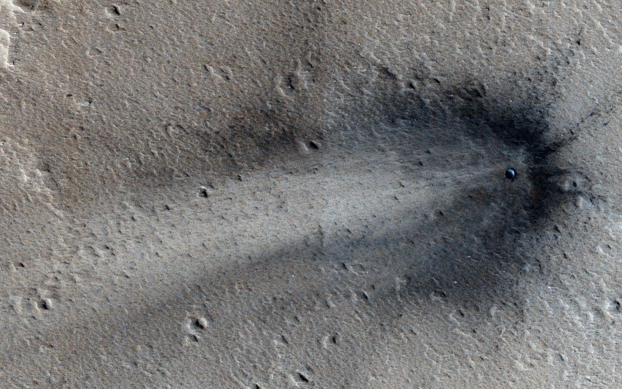
This image from NASA Mars Reconnaissance Orbiter shows a new impact crater in Elysium Planitia.
This observation from NASA Mars Reconnaissance Orbiter shows fractured mounds on the southern edge of Elysium Planitia. The fractures that crisscross their surfaces are probably composed of solidified lava.
This image from NASA Mars Mars Reconnaissance Orbiter shows a triple impact crater in Elysium Planitia near Tartarus Montes, which probably formed when a binary-or even triple-asteroid struck the surface.
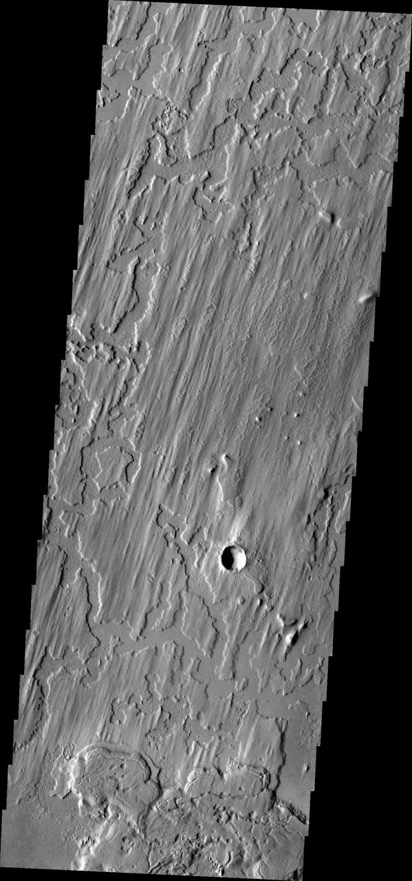
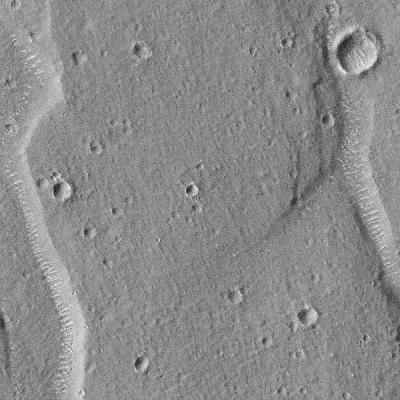
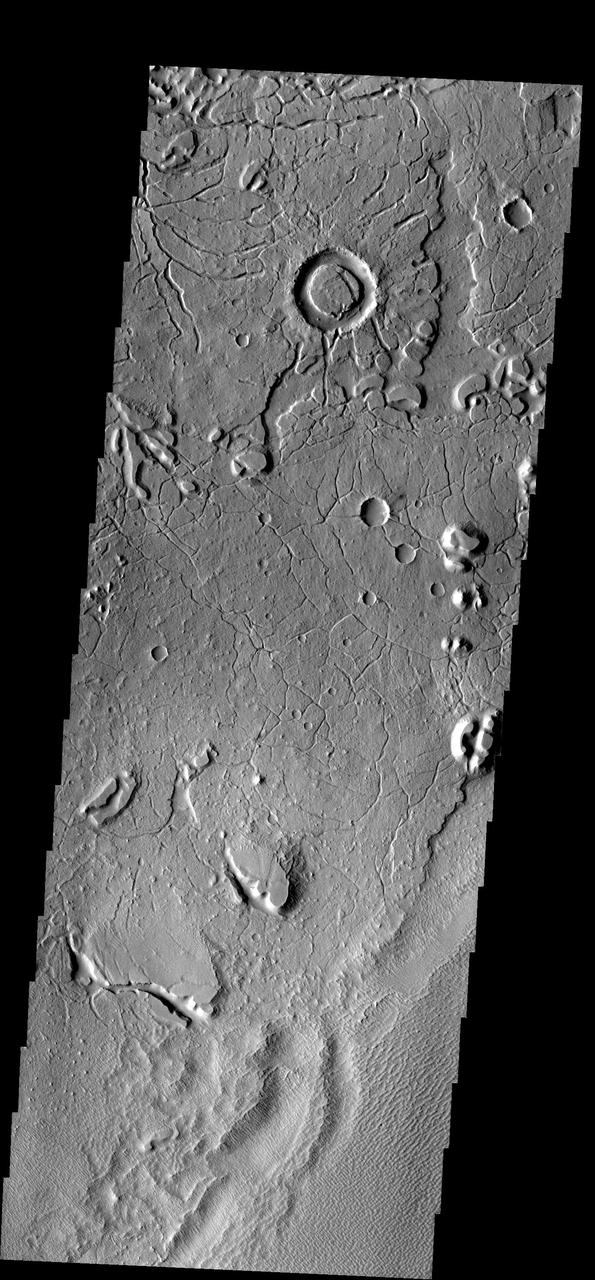
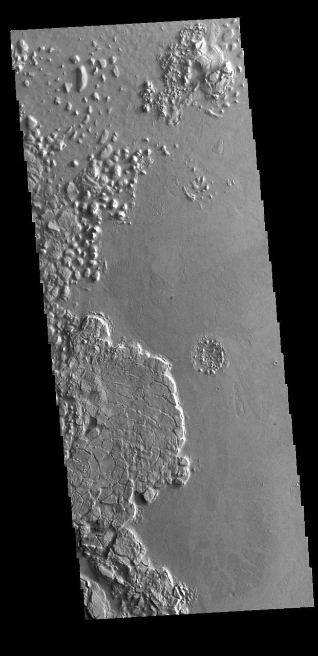
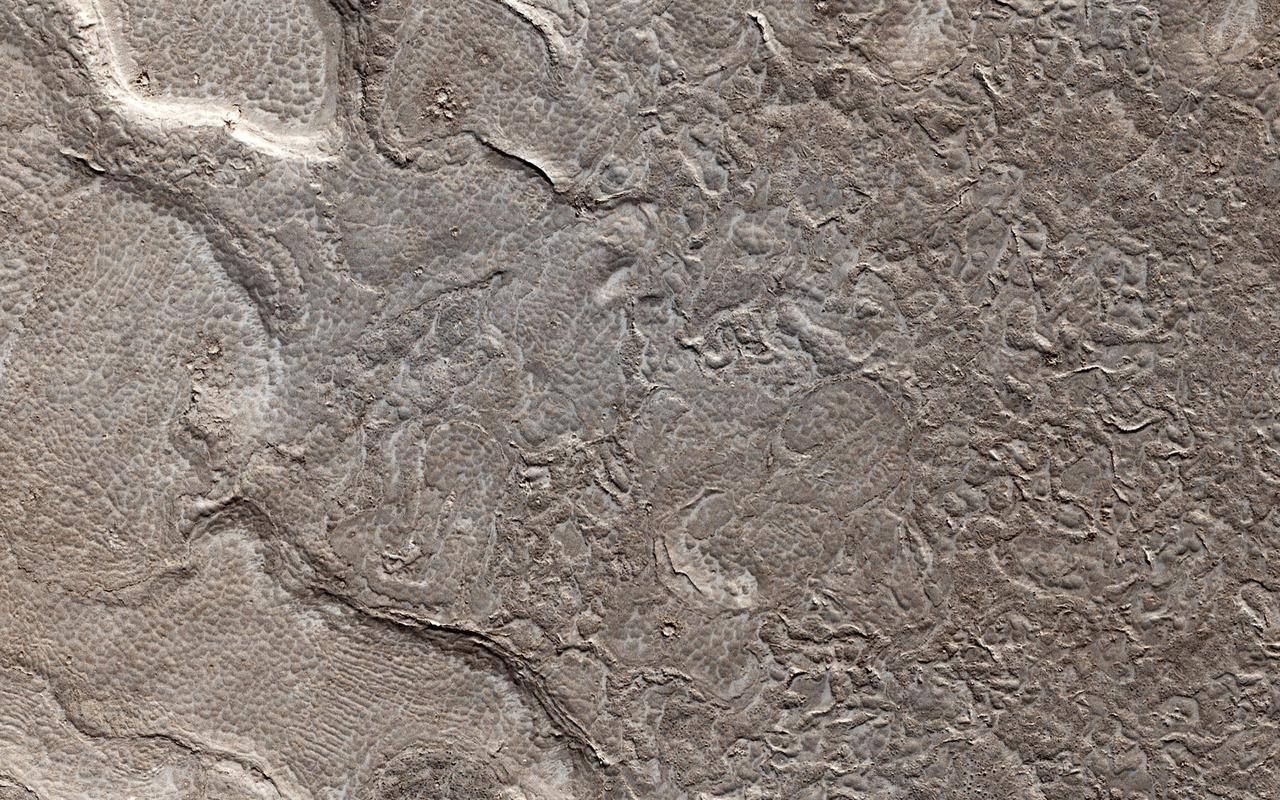
The lowland plains of Elysium Planitia contains a terrain that puzzles Mars scientists. Landforms in the region are the plates and ridges seen throughout most of this image from NASA Mars Odyssey.
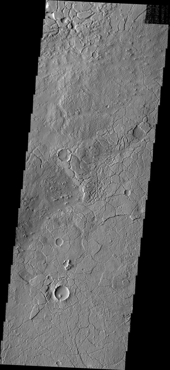
Giant Polygon Troughs, Elysium Planitia
Giant Polygon Troughs, Elysium Planitia at Full Resolution
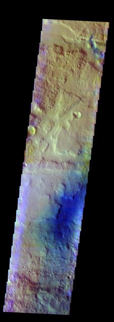
Today's VIS image is located in Elysium Planitia. The linear depressions at the top of the image are created by tectonic faults, where the center block of material has dropped downward between two parallel faults. Blue tones, like those at the bottom of the image, are indicative of basaltic sands. The THEMIS VIS camera contains 5 filters. The data from different filters can be combined in multiple ways to create a false color image. These false color images may reveal subtle variations of the surface not easily identified in a single band image. Orbit Number: 61919 Latitude: 14.9167 Longitude: 161.38 Instrument: VIS Captured: 2015-11-29 04:17 https://photojournal.jpl.nasa.gov/catalog/PIA23087
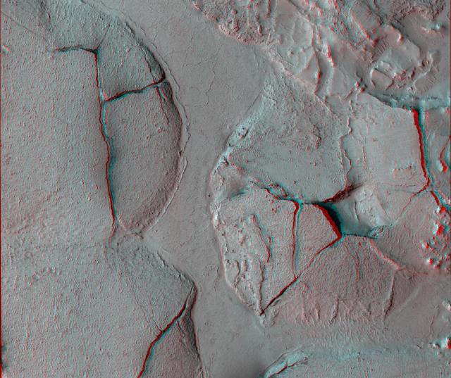
This stereo view shows fractured mounds on the southern edge of Elysium Planitia on Mars. It combines two images from NASA Mars Reconnaissance Orbiter. 3D glasses are necessary to view this image.

This observation from NASA Mars Reconnaissance Orbiter covers a portion of the Martian equatorial plains called Elysium Planitia. In this location, lava that was once flowing across the surface interacted with multiple obstructions.

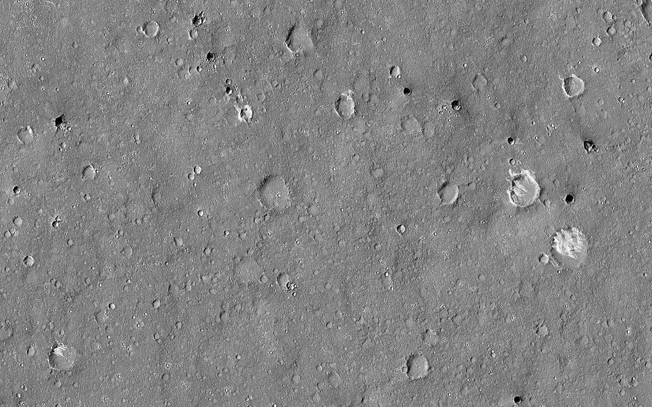
This image from NASA's Mars Reconnaissance Orbiter shows one of millions of small (10s of meters in diameter) craters and their ejecta material that dot the Elysium Planitia region of Mars. The small craters were likely formed when high-speed blocks of rock were thrown out by a much larger impact (about 10-kilometers in diameter) and fell back to the ground. Some of these blocks may actually escape Mars, which is how we get samples in the form of meteorites that fall to Earth. Other ejected blocks have insufficient velocity, or the wrong trajectory, to escape the Red Planet. As such, when one of these high-speed blocks impacts the surface, it makes what is called a "secondary" crater. These secondaries can form dense "chains" or "rays," which are radial to the crater that formed them. https://photojournal.jpl.nasa.gov/catalog/PIA21769
The THEMIS VIS camera contains 5 filters. The data from different filters can be combined in multiple ways to create a false color image. This false color image from NASA 2001 Mars Odyssey spacecraft shows an unnamed crater in Elysium Planitia. Orbit Number: 4951 Latitude: 1.06492 Longitude: 134.035 Instrument: VIS Captured: 2003-01-26 04:19 http://photojournal.jpl.nasa.gov/catalog/PIA19219
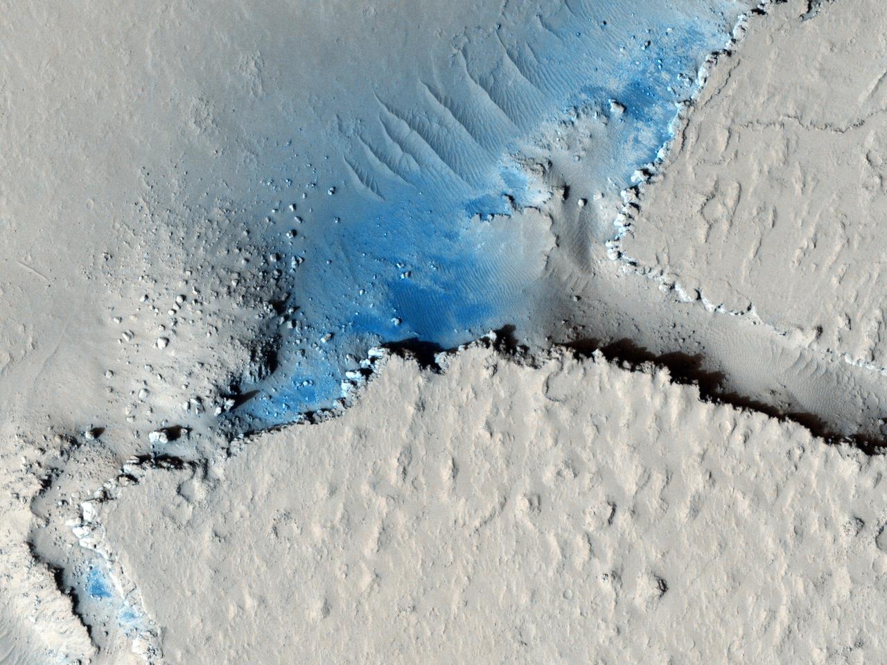
A dominant driver of surface processes on Mars today is aeolian (wind) activity. In many cases, sediment from this activity is trapped in low-lying areas, such as craters. Aeolian features in the form of dunes and ripples can occur in many places on Mars depending upon regional wind regimes. The Cerberus Fossae are a series of discontinuous fissures along dusty plains in the southeastern region of Elysium Planitia. This rift zone is thought to be the result of combined volcano-tectonic processes. Dark sediment has accumulated in areas along the floor of these fissures as well as inactive ripple-like aeolian bedforms known as "transverse aeolian ridges" (TAR). Viewed through HiRISE infrared color, the basaltic sand lining the fissures' floor stands out as deep blue against the light-toned dust covering the region. This, along with the linearity of the fissures and the wave-like appearance of the TAR, give the viewer an impression of a river cutting through the Martian plains. However, this river of sand does not appear to be flowing. Analyses of annual monitoring images of this region have not detected aeolian activity in the form of ripple migration thus far. http://photojournal.jpl.nasa.gov/catalog/PIA21063
These arcuate fractures are located on the margin between Memnonia Fossae and Elysium Planitia
These lava flows surrounding a depression in the plains are located in the Cerberus region of Elysium Planitia
These curved fractures are located on the margin between Memnonia Fossae and Elysium Planitia
Today's VIS image shows part of Zephyria Planum. Zephyria Planum is located south of Elysium Planitia. Long term winds have eroded the surface of Zephyria Planum (bottom half of image). Elysium Planitia covers the top half of the image. The surface contains what looks like plates of material separated by lighter toned regions. This morphology is common in southern Elysium Planitia and it has been suggested that the 'plates' were cooled lava carried along the top of a still molten volcanic flow. Orbit Number: 94719 Latitude: 3.29115 Longitude: 153.155 Instrument: VIS Captured: 2023-04-22 11:11 https://photojournal.jpl.nasa.gov/catalog/PIA26153
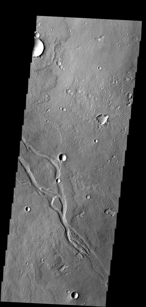
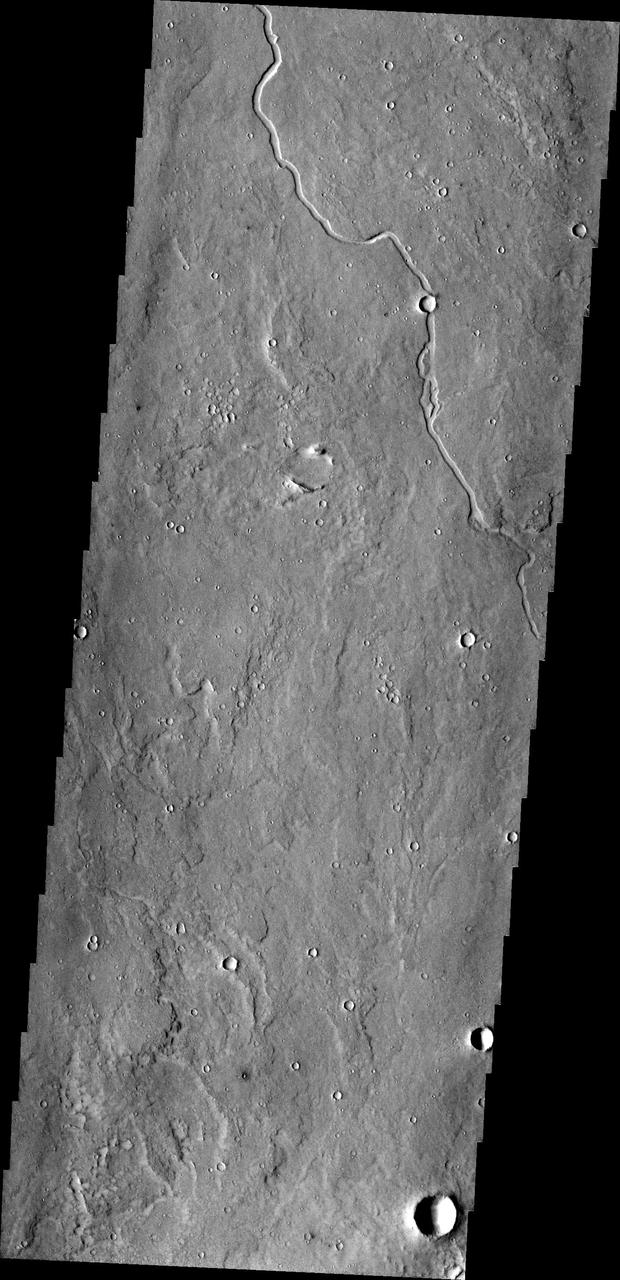
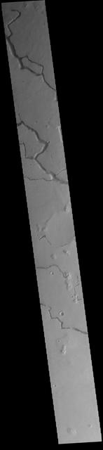
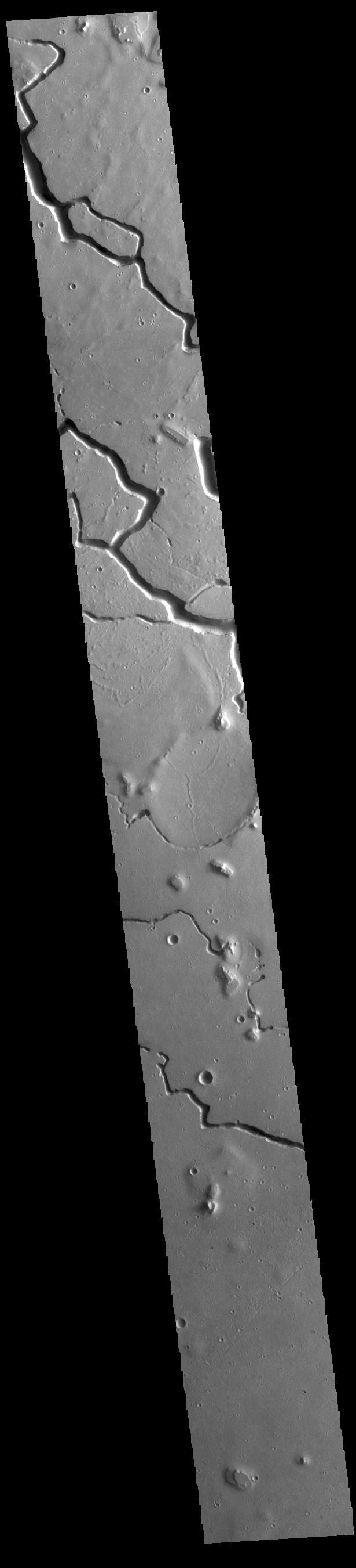
The channels in this image captured by NASA 2001 Mars Odyssey spacecraft are located in Elysium Planitia and were likely created by lava flow.
The arcuate or curved fractures in this image are located on the eastern margin of Elysium Planitia as seen by NASA 2001 Mars Odyssey spacecraft.
Small ripple-like dunes surround hills in the region of Elysium Planitia in this image from NASA Mars Odyssey spacecraft.
This MOC image shows light-toned ripples covering the floors of troughs in the Adamas Labyrinthus region of northern Elysium Planitia
The materials in this region are cracked into individual pieces that with time weather into chaos terrain. This image is located on the southernmost border of Elysium Planitia
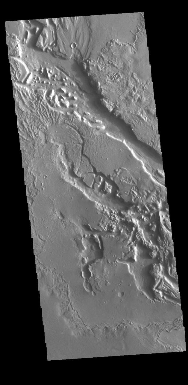
This region of platy lava flows is located in Elysium Planitia. The channel at the bottom of the image may have been the source of the lava
Today's VIS image crosses the boundary between Elysium Planitia (top) and Terra Cimmeria (bottom). This region of Elysium Planitia has been heavily eroded by winds scouring poor cemented surface materials over thousands of years. Orbit Number: 95056 Latitude: -7.8036 Longitude: 152.443 Instrument: VIS Captured: 2023-05-20 05:05 https://photojournal.jpl.nasa.gov/catalog/PIA26255
Winds have scoured this region of Elysium Planitia, sculpting the surface into the small parallel hills seen in this image from NASA 2001 Mars Odyssey spacecraft.
This nighttime temperature image from NASA Mars Odyssey spacecraft shows the ancient, heavily cratered surface of the highlands between Isidis and Elysium Planitia.
Avenus Colles is a region of hills separated by arcuate fractures. These features are the margin between the southern highlands and Elysium Planitia to the north. This image was captured by NASA Mars Odyssey.

The lowland plains of Elysium and Utopia Planitiae are separated from the darker heavily cratered highlands by a broad escarpment in this image from NASA's Viking Orbiter 1. http://photojournal.jpl.nasa.gov/catalog/PIA00196
The unusual texture in this image from NASA 2001 Mars Odyssey spacecraft is located on the plains of Elysium Planitia. The surface appears to be layered. The top layer has parallel, linear hills and channels.

Visible in this observation from NASA Mars Reconnaissance Orbiter is a section of Cerberus Fossae, which are comprised of a series of rifts present located in Elysium Planitia just north the Martian equator.

This MOC image shows some a modest-sized meteor impact crater in the Elysium Planitia region of Mars. The dark spot inside the crater is, most likely, a patch of windblown sand and silt
The style of erosion along the highlands-lowlands boundary of southern Elysium Planitia has produced a strange pattern of troughs that look like the skin of a reptile, as seen in this image from NASA Mars Odyssey spacecraft.
These lava flows in Elysium Planitia captured by NASA Mars Odyssey are called platy flows. The surface of the lava flow cooled and solidified, while liquid lava beneath kept flowing.
The north end of this long image from NASA Mars Reconnaissance Orbiter shows a lava surface in southern Elysium Planitia. Small cones are common on the extensive young flood lavas in this region.
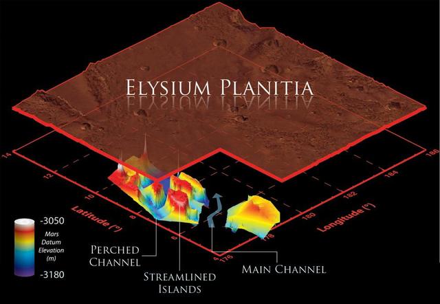
This illustration schematically shows where the Shallow Radar instrument on NASA Mars Reconnaissance Orbiter detected flood channels that had been buried by lava flows in the Elysium Planitia region of Mars.
This image from NASA Mars Odyssey is of a doublet crater located in Utopia Planitia, near the Elysium Volcanic region. Doublet craters are formed by simultaneous impact of a meteor that broke into two pieces prior to hitting the surface.
An isolated mesa east of the Phlegra Montes in northeastern Elysium Planitia has a cracked surface that, combined with its overall shape, gives the appearance of a giant loaf of bread in this image from NASA Mars Odyssey spacecraft.
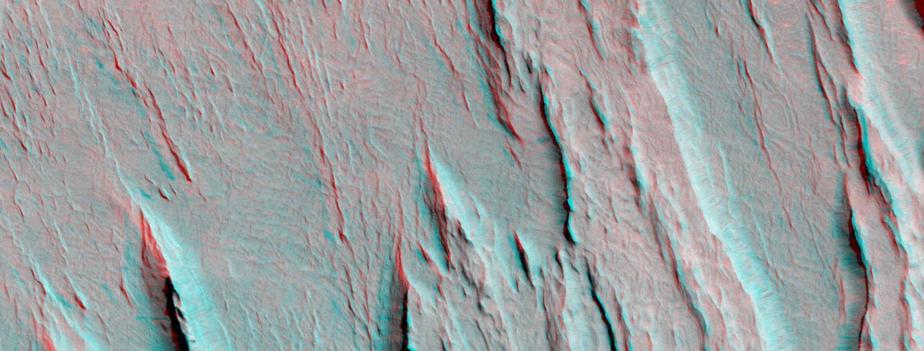
Layers of bedrock etched by wind to form sharp, elongated ridges known to geomorphologists as yardangs are commonplace in the southern Elysium Planitia/southern Amazonis region of Mars. 3D glasses are necessary to view this image.
The north end of this long image from NASA Mars Reconnaissance Orbiter shows a lava surface in southern Elysium Planitia. Small cones are common on the extensive young flood lavas in this region.
This image from NASA Mars Reconnaissance Orbiter shows the funnel-shaped terminus of Lethe Vallis, a winding channel in the Elysium Planitia region of Mars; the floor is covered in solidified lava and blanketed by a thin layer of light-toned dust.
This combination of images, taken by NASA Mars Reconnaissance Orbiter, helped researchers analyze the youngest flood lava on Mars, which is in Athabasca Valles, in the Elysium Planitia region of equatorial Mars.
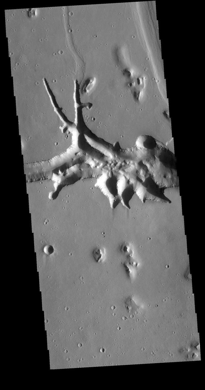
Hebrus Valles is located in the Elysium Planitia region of the northern lowlands of Mars. This image from NASA Mars Odyssey spacecraft shows three sinuous tributaries of the channel system which carved up the surrounding plains.
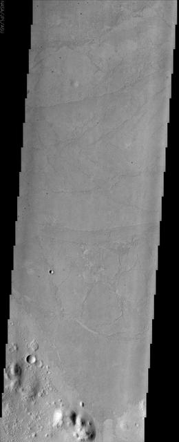
Between the highlands of Terra Cimmeria and the low plains of Elysium Planitia and Nepenthes Planum lies the rugged region called Nepenthes Mensae as seen by NASA 2001 Mars Odyssey spacecraft.

The ejecta of the impact crater shown in this image from NASA Mars Odyssey spacecraft appears to have been modified after it was emplaced. This modification may be due to the presence of subsurface ground ice.
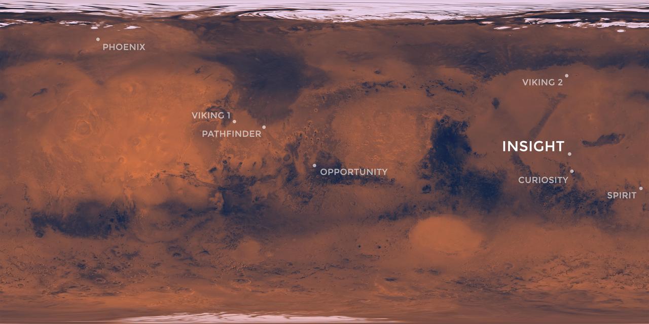
Elysium Planitia, a flat-smooth plain just north of the equator makes for the perfect location from which to study the deep Martian interior. Interior Exploration using Seismic Investigations, Geodesy and Heat Transport, or InSight, is designed to study the deep interior of Mars. The mission seeks the fingerprints of the processes that formed the rocky planets of the solar system. Its landing site, Elysium Planitia, was picked from 22 candidates, and is centered at about 4.5 degrees north latitude and 135.9 degrees east longitude; about 373 miles (600 kilometers) from Curiosity's landing site, Gale Crater. The locations of other Mars landers and rovers are labeled. InSight's scientific success and safe landing depends on landing in a relatively flat area, with an elevation low enough to have sufficient atmosphere above the site for a safe landing. It also depends on landing in an area where rocks are few in number. Elysium Planitia has just the right surface for the instruments to be able to probe the deep interior, and its proximity to the equator ensures that the solar-powered lander is exposed to plenty of sunlight. https://photojournal.jpl.nasa.gov/catalog/PIA22232
This region of arcuate (or curved) fractures is located north of Apollinaris Mons, on the margin with Elysium Planitia. Orbit Number: 86233 Latitude: -3.43549 Longitude: 170.087 Instrument: VIS Captured: 2021-05-23 17:33 https://photojournal.jpl.nasa.gov/catalog/PIA24229
This VIS image shows part of Hephaestus Fossae. Hephaestus Fossae is a complex channel system in Utopia Planitia near Elysium Mons. Orbit Number: 94982 Latitude: 19.5692 Longitude: 123.658 Instrument: VIS Captured: 2023-05-14 03:00 https://photojournal.jpl.nasa.gov/catalog/PIA26225
This image from NASA's Mars Reconnaissance Orbiter (MRO) shows remarkably young lava flows in Elysium Planitia. There are almost no impact craters over this flow, indicating that it is probably only a few million years old -- practically an infant in geologic time. For more information see https://photojournal.jpl.nasa.gov/catalog/PIA22432
This VIS image is located in the southeastern portion of Hephaestus Fossae. Hephaestus Fossae is a complex channel system in Utopia Planitia near Elysium Mons. It has been proposed that the channel formed by the release of melted subsurface ice during the impact event that created a large crater west of this image. Additionally, the nearby Elysium volcanic center created subsurface heating that may have played a part in creating both Hephaestus Fossae and Hebrus Valles to the north. Hephaestus Fossae are over 600km long (373 miles). Orbit Number: 78847 Latitude: 17.5748 Longitude: 126.158 Instrument: VIS Captured: 2019-09-23 13:59 https://photojournal.jpl.nasa.gov/catalog/PIA23507
This VIS image is located in the central portion of Hephaestus Fossae. Hephaestus Fossae is a complex channel system in Utopia Planitia near Elysium Mons. It has been proposed that the channel formed by the release of melted subsurface ice during the impact event that created a large crater southeast of this image. Additionally, the nearby Elysium volcanic center created subsurface heating that may have played a part in creating both Hephaestus Fossae and Hebrus Valles to the north. Orbit Number: 82079 Latitude: 18.8004 Longitude: 124.5724 Instrument: VIS Captured: 2020-06-15 16:56 https://photojournal.jpl.nasa.gov/catalog/PIA24122
This VIS image is located in the central portion of Hephaestus Fossae. Hephaestus Fossae is a complex channel system in Utopia Planitia near Elysium Mons. It has been proposed that the channel formed by the release of melted subsurface ice during the impact event that created a large crater south of this image. Additionally, the nearby Elysium volcanic center created subsurface heating that may have played a part in creating both Hephaestus Fossae and Hebrus Valles to the north. Orbit Number: 77487 Latitude: 18.8111 Longitude: 124.593 Instrument: VIS Captured: 2019-06-03 14:10 https://photojournal.jpl.nasa.gov/catalog/PIA23335
Today's VIS image shows the surface between Aeolis Planum and Zephyria Planum in Elysium Planitia. Long term winds have eroded the surface in this region. Features align with wind direction, and the multiple ridge orientations in this image indicate varying wind directions over time. Orbit Number: 79757 Latitude: -5.05219 Longitude: 155.498 Instrument: VIS Captured: 2019-12-07 12:12 https://photojournal.jpl.nasa.gov/catalog/PIA23708
Called Avernus Colles, these broken blocks and arcuate fractures mark the transition region between the southern highlands and the northern lowlands of Mars north of Apollinaris Mons, on the margin with Elysium Planitia. Orbit Number: 88167 Latitude: 1.23136 Longitude: 175.576 Instrument: VIS Captured: 2021-10-29 23:24 https://photojournal.jpl.nasa.gov/catalog/PIA25155
A variegated mottled texture located NW of the volcano Elysium Monsis is readily apparent in the terrain imaged here by NASA Mars Odyssey spacecraft. The Hrad Vallis channel system can be seen sauntering across the bumpy landscape of Utopia Planitia.
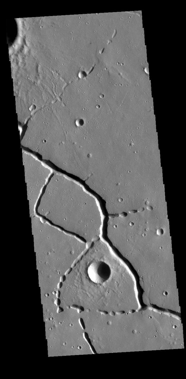
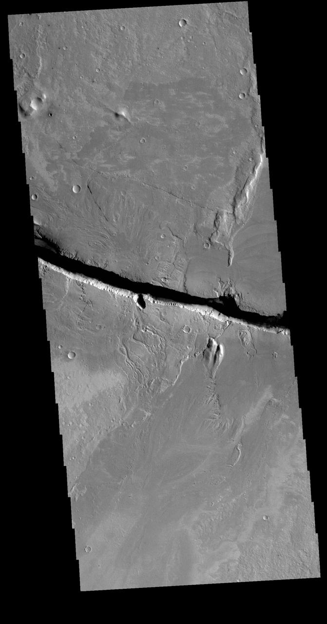
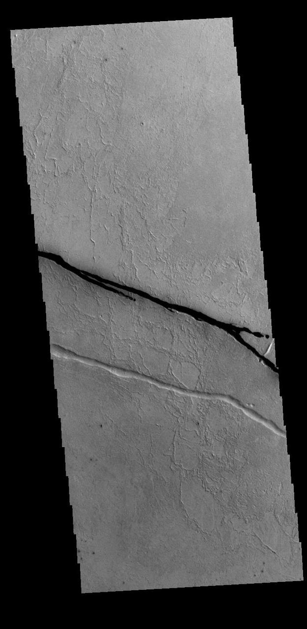
Today's VIS image shows part of Cerberus Fossae. These large graben cut across the Tartarus Montes in Elysium Planitia. A graben is formed when large blocks of material slid downward between paired faults in regions of extensional stresses. Orbit Number: 77648 Latitude: 10.0918 Longitude: 160.48 Instrument: VIS Captured: 2019-06-16 20:19 https://photojournal.jpl.nasa.gov/catalog/PIA23364
Today's VIS image shows the surface on the western margin of Zephyria Planum. Zephyria Planum is located south of Elysium Planitia. Long term winds have eroded the surface in this region. Features align with wind direction, and the multiple ridge orientations in this image indicate varying wind directions over time. Orbit Number: 80955 Latitude: -4.15683 Longitude: 154.144 Instrument: VIS Captured: 2020-03-15 03:38 https://photojournal.jpl.nasa.gov/catalog/PIA23907
This VIS image is located at the eastern end of Hephaestus Fossae. Hephaestus Fossae is a channel system in Utopia Planitia near Elysium Mons. It has been proposed that the channel formed by the release of melted subsurface ice during the impact event that created a large crater west of this image. The method of formation for this complex feature at end of the channel is still unknown. Orbit Number: 72659 Latitude: 17.3167 Longitude: 126.988 Instrument: VIS Captured: 2018-05-01 22:42 https://photojournal.jpl.nasa.gov/catalog/PIA22621
This VIS image shows part of Athabasca Valles. Arising from Cerberus Fossae, the formation mode of this channel is still being debated. While the channel features are similar to water flow, other features are similar to lava flows, and then other features have an appearance of slabs of material that floated on a underlying fluid. This is just one of the complex channel formations in the Elysium Planitia region. Orbit Number: 78297 Latitude: 8.93976 Longitude: 155.611 Instrument: VIS Captured: 2019-08-09 06:58 https://photojournal.jpl.nasa.gov/catalog/PIA23472
Today's VIS image shows a single linear depression, most likely a graben. This region is located just south of Cerberus Fossae, so it may have formed at the same time. Several Cerberus Fossae graben have also been source regions for flow features. Orbit Number: 94756 Latitude: 7.92391 Longitude: 165.118 Instrument: VIS Captured: 2023-04-25 12:20 https://photojournal.jpl.nasa.gov/catalog/PIA26155
A sinuous ridge is a thin and meandering formation that gives the appearance of a stream channel, but stays raised above the surface rather than incised into it. It is believed that these ridges were once stream channels that cut down into the surface. Flowing water can have a number of effects on a channel bed, such as sorting grains and depositing rocks, all while removing loose material. The water can also carry a number of dissolved minerals that become deposited and cement the remaining grains together. The result is a stream bed that has become "armored." Once the stream stops flowing and dries up, this armored layer can resist future erosion. Over the millions of years that follow, forces such as wind can gradually remove the original material of the surrounding terrain, but the stream bed can remain. Examining the characteristics of the ridge can reveal clues about the amount of water and the flow speed that existed long ago. https://photojournal.jpl.nasa.gov/catalog/PIA24470
This VIS image is located in the northern portion of Hephaestus Fossae. Hephaestus Fossae is a complex channel system in Utopia Planitia near Elysium Mons. It has been proposed that the channels formed by the release of melted subsurface ice during the impact event that created a large crater southeast of this image. Additionally, the nearby Elysium volcanic center created subsurface heating that may have played a part in creating both Hephaestus Fossae and Hebrus Valles to the north. The right angle intersections indicate there is some tectonic activity in the region, and the circular depressions indicate surface collapse into subsurface voids. Hephaestus Fossae is a very complex set of features. Orbit Number: 88618 Latitude: 22.2991 Longitude: 121.441 Instrument: VIS Captured: 2021-12-06 02:47 https://photojournal.jpl.nasa.gov/catalog/PIA25199
This VIS image is located in the northern portion of Hephaestus Fossae. Hephaestus Fossae is a complex channel system in Utopia Planitia near Elysium Mons. It has been proposed that the channels formed by the release of melted subsurface ice during the impact event that created a large crater southeast of this image. Additionally, the nearby Elysium volcanic center created subsurface heating that may have played a part in creating both Hephaestus Fossae and Hebrus Valles to the north. The right angle intersections indicate there is some tectonic activity in the region, and the circular depressions indicate surface collapse into subsurface voids. Hephaestus Fossae is a very complex set of features. Orbit Number: 85960 Latitude: 21.3916 Longitude: 122.454 Instrument: VIS Captured: 2021-05-01 06:13 https://photojournal.jpl.nasa.gov/catalog/PIA24212
This VIS image is located in the northern portion of Hephaestus Fossae. Hephaestus Fossae is a complex channel system in Utopia Planitia near Elysium Mons. It has been proposed that the channels formed by the release of melted subsurface ice during the impact event that created a large crater southeast of this image. Additionally, the nearby Elysium volcanic center created subsurface heating that may have played a part in creating both Hephaestus Fossae and Hebrus Valles to the north. The right angle intersections indicate there is some tectonic activity in the region, and the circular depressions indicate surface collapse into subsurface voids. Hephaestus Fossae is a very complex set of features. Orbit Number: 88019 Latitude: 21.1587 Longitude: 122.646 Instrument: VIS Captured: 2021-10-17 19:02 https://photojournal.jpl.nasa.gov/catalog/PIA25111
This false color image from NASA 2001 Mars Odyssey spacecraft shows an unnamed channel on the margin between the higher elevations of Terra Cimmeria and the lower elevations of Elysium Planitia. Orbit Number: 7648 Latitude: -8.87244 Longitude: 143.027 Instrument: VIS Captured: 2003-09-05 02:35 http://photojournal.jpl.nasa.gov/catalog/PIA19487
This VIS image shows a section of Cerberus Fossae. Located southeast of the Elysium Planitia volcanic complex, the linear graben was created by tectonic forces related to the volcanic activity. The fossae cuts across features such as hills, indicating the relative youth of the tectonic activity. The fossae is also the source of several channels, some of which are visible on the bottom of the fossae. Orbit Number: 71498 Latitude: 9.94964 Longitude: 157.873 Instrument: VIS Captured: 2018-01-26 07:16 https://photojournal.jpl.nasa.gov/catalog/PIA22397
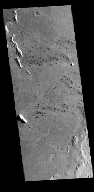
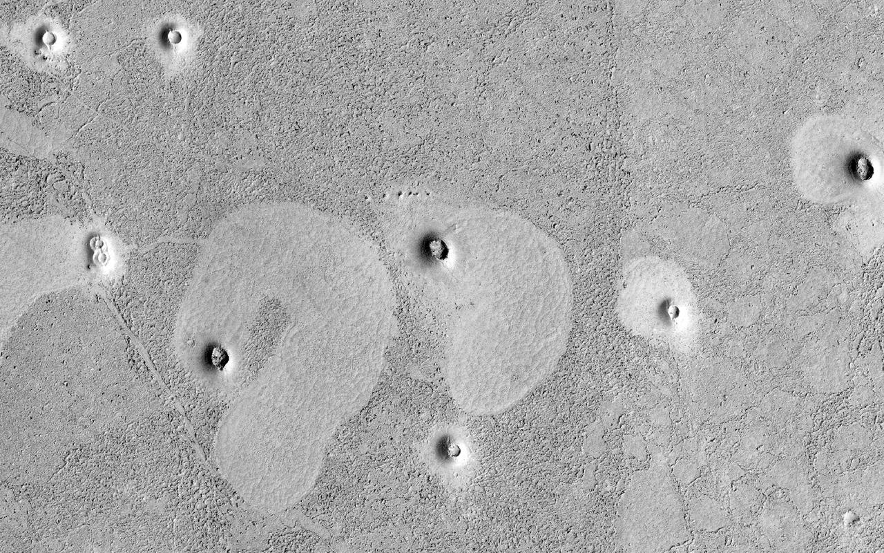
This field of small dark craters is located in southern Elysium Planitia. The dark appearance against the surrounding lava flows suggests that the craters post-date the lava flows. The small "tails" near the craters indicate winds blowing toward the upper left of the image. Orbit Number: 69752 Latitude: 8.2881 Longitude: 157.48 Instrument: VIS Captured: 2017-09-04 10:56 https://photojournal.jpl.nasa.gov/catalog/PIA22361
Today's VIS image shows a small section of Hrad Vallis. Hrad Vallis originates on the northwest margin of the Elysium Volcanic complex and flows into Utopia Planitia. Hrad Vallis is 825 km (513 miles) long. Orbit Number: 85822 Latitude: 33.8698 Longitude: 141.725 Instrument: VIS Captured: 2021-04-19 21:35 https://photojournal.jpl.nasa.gov/catalog/PIA24877
Today's VIS image shows a section of Cerberus Fossae. Cerberus Fossae are located in Elysium Planitia, southeast of the Elysium Mons volcanic complex. The linear features in the image are tectonic graben. Graben are formed by extension of the crust and faulting. When large amounts of pressure or tension are applied to rocks on timescales that are fast enough that the rock cannot respond by deforming, the rock breaks along faults. In the case of a graben, two parallel faults are formed by extension of the crust and the rock in between the faults drops downward into the space created by the extension. Numerous sets of graben are visible in this THEMIS image, trending from north-northwest to south-southeast. Because the faults defining the graben are formed perpendicular to the direction of the applied stress, we know that extensional forces were pulling the crust apart in the east-northeast/west-southwest direction. The Cerberus Fossae graben are sources of both channels and significant volcanic flows. Cerberus Fossae cuts across features such as hills, indicating the relative youth of the tectonic activity. Orbit Number: 93945 Latitude: 8.24256 Longitude: 161.492 Instrument: VIS Captured: 2023-02-17 17:42 https://photojournal.jpl.nasa.gov/catalog/PIA25933
Today's VIS image shows a section of Cerberus Fossae. Cerberus Fossae are located in Elysium Planitia, southeast of the Elysium Mons volcanic complex. The linear features in the image are tectonic graben. Graben are formed by extension of the crust and faulting. When large amounts of pressure or tension are applied to rocks on timescales that are fast enough that the rock cannot respond by deforming, the rock breaks along faults. In the case of a graben, two parallel faults are formed by extension of the crust and the rock in between the faults drops downward into the space created by the extension. Numerous sets of graben are visible in this THEMIS image, trending from north-northwest to south-southeast. Because the faults defining the graben are formed perpendicular to the direction of the applied stress, we know that extensional forces were pulling the crust apart in the east-northeast/west-southwest direction. The Cerberus Fossae graben are sources of both channels and significant volcanic flows. Cerberus Fossae cuts across features such as hills, indicating the relative youth of the tectonic activity. Orbit Number: 94781 Latitude: 8.95114 Longitude: 163.746 Instrument: VIS Captured: 2023-04-27 13:44 https://photojournal.jpl.nasa.gov/catalog/PIA26156
Today's VIS image shows a section of Cerberus Fossae. Cerberus Fossae are located in Elysium Planitia, southeast of the Elysium Mons volcanic complex. The linear features in the image are tectonic graben. Graben are formed by extension of the crust and faulting. When large amounts of pressure or tension are applied to rocks on timescales that are fast enough that the rock cannot respond by deforming, the rock breaks along faults. In the case of a graben, two parallel faults are formed by extension of the crust and the rock in between the faults drops downward into the space created by the extension. Two graben are visible in this THEMIS image, trending from west-northwest to east-southeast. Because the faults defining the graben are formed perpendicular to the direction of the applied stress, we know that extensional forces were pulling the crust apart in the north-northeast/south-southwest direction. The Cerberus Fossae graben are sources of both channels and significant volcanic flows. The rough surface around the graben is thought to be volcanic flows. Cerberus Fossae cuts across features such as hills, indicating the relative youth of the tectonic activity. Orbit Number: 94494 Latitude: 8.856 Longitude: 163.378 Instrument: VIS Captured: 2023-04-03 22:36 https://photojournal.jpl.nasa.gov/catalog/PIA26031
Today's VIS image shows a section of Cerberus Fossae. Cerberus Fossae are located in Elysium Planitia, southeast of the Elysium Mons volcanic complex. The linear features in the image are tectonic graben. Graben are formed by extension of the crust and faulting. When large amounts of pressure or tension are applied to rocks on timescales that are fast enough that the rock cannot respond by deforming, the rock breaks along faults. In the case of a graben, two parallel faults are formed by extension of the crust and the rock in between the faults drops downward into the space created by the extension. Numerous sets of graben are visible in this THEMIS image, trending from north-northwest to south-southeast. Because the faults defining the graben are formed perpendicular to the direction of the applied stress, we know that extensional forces were pulling the crust apart in the east-northeast/west-southwest direction. The Cerberus Fossae graben are sources of both channels and significant volcanic flows. Cerberus Fossae cuts across features such as hills, indicating the relative youth of the tectonic activity. The Cerberus Fossae system is 1235km (767 miles) long. Orbit Number: 94282 Latitude: 9.86336 Longitude: 159.223 Instrument: VIS Captured: 2023-03-17 11:40 https://photojournal.jpl.nasa.gov/catalog/PIA26000
Today's VIS image shows a section of Cerberus Fossae. Cerberus Fossae are located in Elysium Planitia, southeast of the Elysium Mons volcanic complex. The linear features in the image are tectonic graben. Graben are formed by extension of the crust and faulting. When large amounts of pressure or tension are applied to rocks on timescales that are fast enough that the rock cannot respond by deforming, the rock breaks along faults. In the case of a graben, two parallel faults are formed by extension of the crust and the rock in between the faults drops downward into the space created by the extension. Several sets of graben are visible in this THEMIS image, trending from west-northwest to east-southeast. Because the faults defining the graben are formed perpendicular to the direction of the applied stress, we know that extensional forces were pulling the crust apart in the north-northeast/south-southwest direction. The Cerberus Fossae graben are sources of both channels and significant volcanic flows. Cerberus Fossae cuts across features such as hills, indicating the relative youth of the tectonic activity. The Cerberus Fossae system is 1235km (767 miles) long. Orbit Number: 94232 Latitude: 10.1207 Longitude: 161.626 Instrument: VIS Captured: 2023-03-13 08:52 https://photojournal.jpl.nasa.gov/catalog/PIA25999
The linear depressions in the middle of this VIS image are graben called Cerberus Fossae. Graben form where extensional tectonic forces allows blocks of material to subside between paired faults. Cerberus Fossae are located in Elysium Planitia, southeast of the Elysium Mons volcanic complex. Orbit Number: 87793 Latitude: 15.3137 Longitude: 163.349 Instrument: VIS Captured: 2021-09-29 04:24 https://photojournal.jpl.nasa.gov/catalog/PIA25292
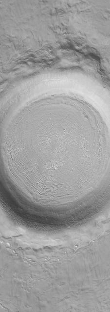
The THEMIS VIS camera contains 5 filters. The data from different filters can be combined in multiple ways to create a false color image. These false color images may reveal subtle variations of the surface not easily identified in a single band image. Today's false color image shows the western half of Tombaugh Crater. Tombaugh Crater is located in Elysium Planitia and is 60km (37 miles) in diameter. Orbit Number: 79320 Latitude: 3.55509 Longitude: 161.686 Instrument: VIS Captured: 2019-11-01 12:40 https://photojournal.jpl.nasa.gov/catalog/PIA24671
Today's VIS image shows part of Cerberus Fossae. These large graben cut across the Tartarus Montes in Elysium Planitia. A graben forms when large blocks of material slide downward between paired faults in regions of extensional stresses. The straight sides and uniform depths are indications that these are tectonic features rather than channels caused by fluid erosion. Cerberus Fossae graben are 1235 km long, approximately the distance between Los Angeles, California and Albuquerque, New Mexico. Orbit Number: 78222 Latitude: 10.4327 Longitude: 159.273 Instrument: VIS Captured: 2019-08-03 02:45 https://photojournal.jpl.nasa.gov/catalog/PIA23449
In the northern section of this from image NASA Mars Reconnaissance Orbiter, we see flat terrain that is probably an ancient lava field. These dust avalanches are common in dust-covered regions on Mars.
This HiRISE image was taken to sample terrain north of Elysium Planitia and Athabasca Valles. Because HiRISE can only image a small fraction of Mars, most images are targeted on specially selected features of interest. However, we also sample other locations, both to understand the normal terrain and look for things that might not have been obvious enough in other data for anyone to mark out a target. This image caught something interesting. Most of the surface is smooth regolith peppered with small craters. However, some of the craters are notably dark compared with everything else in the image. Zooming in to full resolution shows the reason: the dark craters have small ripples and are dark blue in enhanced color, characteristics usually associated with active sand kicking off its dust cover. Why the sand is moving in these particular craters but not others is not certain but could relate to induration (hardening) of the sand, or the age or topography of the craters. https://photojournal.jpl.nasa.gov/catalog/PIA23427
A partial view of the deck of NASA's InSight lander, where it stands on the Martian plains Elysium Planitia. The color-calibrated image was received on Dec. 4, 2018 (Sol 8). InSight's robotic arm with its stowed grapple can be seen above the deck, and jutting out from the front of the deck is one of the boxy attitude control system thrusters that helped control the spacecraft's landing. The circular silver inset of the propellant tank can also be seen in the middle of the image, as well as one of the connections for the aeroshell and parachute, which looks like a cupholder in the foreground. Next to the propellant tank is the UHF antenna, which helps the lander communicate with Earth. In the background, part of one of InSight's solar panels is visible. https://photojournal.jpl.nasa.gov/catalog/PIA22873
This VIS image shows part of Hephaestus Fossae. Hephaestus Fossae is a complex channel system in Utopia Planitia near Elysium Mons. It has been proposed that the channel formed by the release of melted subsurface ice during the impact event that created the crater just off the left side of the image – only the ejecta is seen in this image. The crater is fairly young, as there is only minimal modification of the crater floor. While it appears that the crater sits of top of the channel, the creation of the crater may have also created the channel. The impact event would have caused subsurface heating, melting any subsurface ice in the region which would have created surface flow to form the channel. Additionally, the nearby Elysium volcanic center created subsurface heating that may have played a part in creating both Hephaestus Fossae and Hebrus Valles to the north. Orbit Number: 94645 Latitude: 17.6141 Longitude: 126.055 Instrument: VIS Captured: 2023-04-16 09:02 https://photojournal.jpl.nasa.gov/catalog/PIA26040
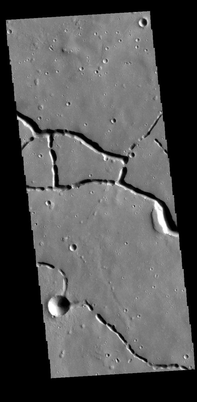
The linear depressions at the top half of this VIS image are graben that are called Cerberus Fossae. Graben form where extensional tectonic forces allows blocks of material to subside between paired faults. Cerberus Fossae are located in Elysium Planitia, southeast of the Elysium Mons volcanic complex. This graben is also the source of significant liquid flows, which created Athabasca Valles. The actual formation liquid proposed include flood water, low viscosity lava, and even glaciers. It is possible that water and lava both played a role in creating the channel system. Orbit Number: 78821 Latitude: 10.1133 Longitude: 157.297 Instrument: VIS Captured: 2019-09-21 10:33 https://photojournal.jpl.nasa.gov/catalog/PIA23503
This VIS image is located in the central portion of Hephaestus Fossae. Hephaestus Fossae is a complex channel system in Utopia Planitia near Elysium Mons. It has been proposed that the channel formed by the release of melted subsurface ice during the impact event that created the crater in this image. Additionally, the nearby Elysium volcanic center created subsurface heating that may have played a part in creating both Hephaestus Fossae and Hebrus Valles to the north. Orbit Number: 81193 Latitude: 18.8168 Longitude: 124.985 Instrument: VIS Captured: 2020-04-03 18:04 https://photojournal.jpl.nasa.gov/catalog/PIA23938
This VIS image is located in the central portion of Hephaestus Fossae. Hephaestus Fossae is a complex channel system in Utopia Planitia near Elysium Mons. It has been proposed that the channel formed by the release of melted subsurface ice during the impact event that created a large crater south of this image. Additionally, the nearby Elysium volcanic center created subsurface heating that may have played a part in creating both Hephaestus Fossae and Hebrus Valles to the north. Orbit Number: 79159 Latitude: 19.0493 Longitude: 124.534 Instrument: VIS Captured: 2019-10-19 06:34 https://photojournal.jpl.nasa.gov/catalog/PIA23579
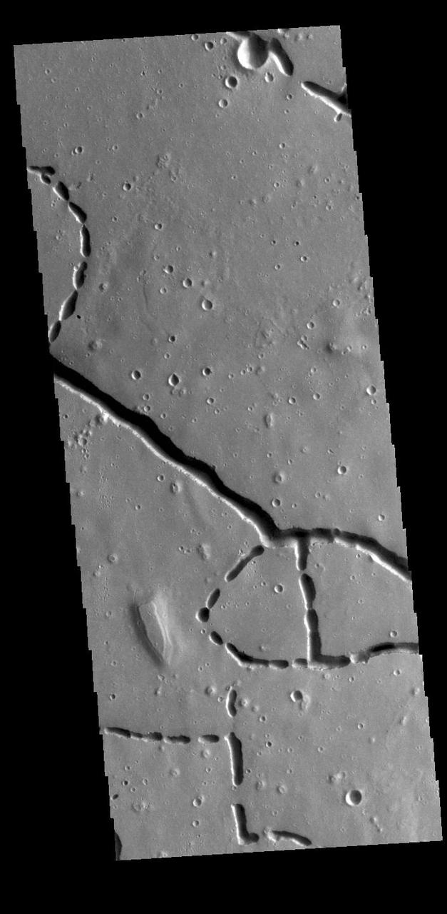
The linear depressions at the top of the VIS image are some of the graben that comprise Cerberus Fossae. Graben form where extensional tectonic forces allows blocks of material to subside between paired faults. Cerberus Fossae is located in Elysium Planitia, southeast of the Elysium Mons volcanic complex. These graben were also the source of significant volcanic flows, creating the flow features to the top and the bottom of the graben. These flows are called Athabasca Valles. Water may have also been released from the graben, creating a complex history for channel forms in this region. Orbit Number: 79108 Latitude: 10.0044 Longitude: 157.144 Instrument: VIS Captured: 2019-10-15 01:44 https://photojournal.jpl.nasa.gov/catalog/PIA23568
The linear depressions at the top of the VIS image are some of the graben that comprise Cerberus Fossae. Graben form where extensional tectonic forces allows blocks of material to subside between paired faults. Cerberus Fossae are located in Elysium Planitia, southeast of the Elysium Mons volcanic complex. The graben were also the source of significant volcanic flows, creating the deposits seen at the lower part of the image. Orbit Number: 77985 Latitude: 9.97726 Longitude: 157.285 Instrument: VIS Captured: 2019-07-14 14:21 https://photojournal.jpl.nasa.gov/catalog/PIA23400
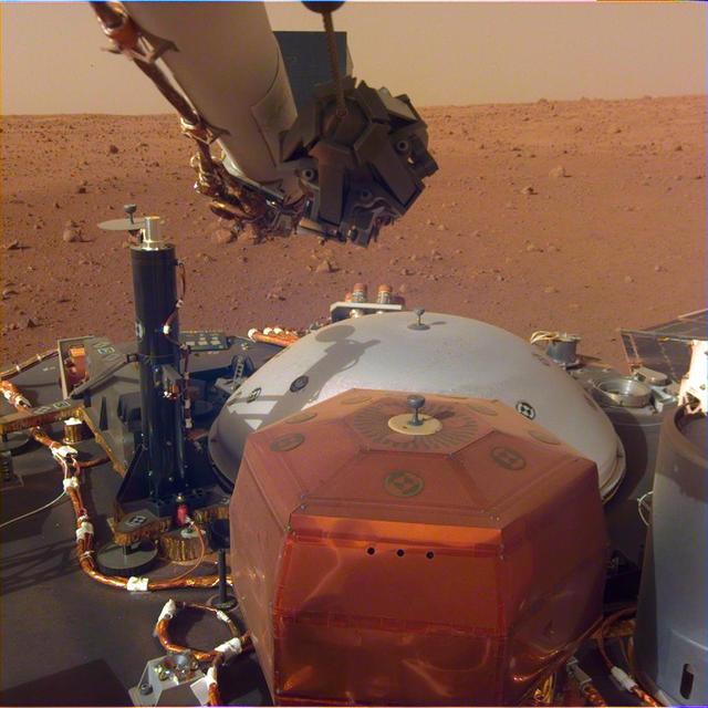
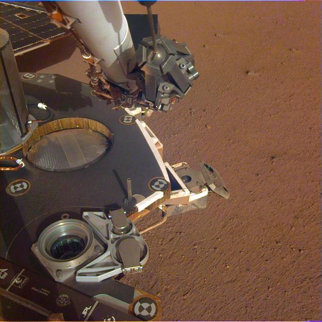
This image from InSight's robotic-arm mounted Instrument Deployment Camera shows the instruments on the spacecraft's deck, with the Martian surface of Elysium Planitia in the background. The color-calibrated picture was acquired on Dec. 4, 2018 (Sol 8). In the foreground, a copper-colored hexagonal cover protects the Seismic Experiment for Interior Structure instrument (SEIS), a seismometer that will measure marsquakes. The gray dome behind SEIS is the wind and thermal shield, which will be placed over SEIS. To the left is a black cylindrical instrument, the Heat Flow and Physical Properties Probe (HP3). HP3 will drill up to 16 feet (5 meters) below the Martian surface, measuring heat released from the interior of the planet. Above the deck is InSight's robotic arm, with the stowed grapple directly facing the camera. To the right can be seen a small portion of one of the two solar panels that help power InSight and part of the UHF communication antenna. https://photojournal.jpl.nasa.gov/catalog/PIA22871
This image shows lava crumpled against the upstream side of an impact crater as seen by NASA Mars Reconnaissance Orbiter.
This VIS image is located in Utopia Planitia and shows part of Hephaestus Fossae. Hephaestus Fossae is a complex channel system. It has been proposed that the channel formed by the release of melted subsurface ice during an impact event. Additionally, the nearby Elysium volcanic center created subsurface heating that may have played a part in creating both Hephaestus Fossae and Hebrus Valles to the north. Orbit Number: 85286 Latitude: 17.535 Longitude: 127.087 Instrument: VIS Captured: 2021-03-06 18:17 https://photojournal.jpl.nasa.gov/catalog/PIA24823
Today's VIS image shows the surface of Zephyria Planum and the surrounding plains. Zephyria Planum is located south of Elysium Planitia. Long term winds have eroded the surface of Zephyria Planum (top of image) and the surrounding plains. Small, linear sand dunes are visible in the rest of the image. Orbit Number: 81217 Latitude: -5.45343 Longitude: 155.853 Instrument: VIS Captured: 2020-04-05 17:22 https://photojournal.jpl.nasa.gov/catalog/PIA23945
This image NASA Mars Reconnaissance Orbiter shows an impact crater that was cut by lava in the Elysium Planitia region of Mars. It looks relatively flat, with a shallow floor, rough surface texture, and possible cooling cracks seem to indicate that the crater was partially filled with lava. The northern part of the image also shows a more extensive lava flow deposit that surrounds the impact ejecta of the largest impact crater in the image. Which way did the lava flow? It might appear that the lava flowed from the north through the channel into the partially filled crater. However, if you look at the anaglyph with your red and blue 3D glasses, it becomes clear that the partially filled crater sits on top of the large crater's ejecta blanket, making it higher than the lava flow to the north. Since lava does not flow uphill, that means the explanation isn't so simple. http://photojournal.jpl.nasa.gov/catalog/PIA18887
This 2.5-kilometer diameter crater observed by NASA's Mars Reconnaissance Orbiter has been significantly altered from the usual bowl-shaped appearance we associate with craters. Material has covered significant portions of the ejecta and filled in the crater. This fill material has since been subject to erosion -- like boulders weathering out of the slopes -- and the crater rim is also highly irregular. This crater is located in Elysium Planitia, an area dominated by volcanic processes. It is likely that the crater fill material is volcanic in origin, and possible that the rim was etched by lava, either flowing into the crater or spilling over after the crater filled completely. However, there are also signs of erosion by wind, like the parallel ridges in the rim breaches and between high-standing regions of the crater fill. It is likely that the current appearance of this crater is due to a combination of surface processes. https://photojournal.jpl.nasa.gov/catalog/PIA22041
This image is located along the margin between Terra Cimmeria and Elysium Planitia. This boundary region is typified by tectonic fractures forming long, linear depressions. The crater in the lower half of the image has a hexagon shape rather than the normal circular outline. The regional surface/subsurface fracture system deflected the impact generated pressure waves along the tectonic network, causing the linear sides we see in the image. Meteor Crater in northern Arizona has a similar flat sided shape, in that case a square rather than a hexagon. The Arizona crater impacted into sandstone and limestone that had a right angle fracture system. Orbit Number: 78210 Latitude: -7.13006 Longitude: 147.811 Instrument: VIS Captured: 2019-08-02 02:56 https://photojournal.jpl.nasa.gov/catalog/PIA23448
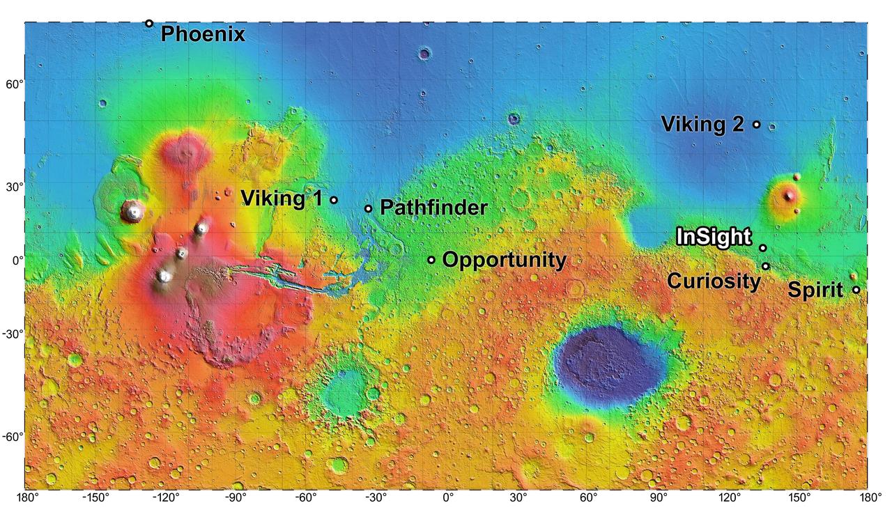
The process of selecting a site for NASA's next landing on Mars, planned for September 2016, has narrowed to four semifinalist sites located close together in the Elysium Planitia region of Mars. The mission known by the acronym InSight will study the Red Planet's interior, rather than surface features, to advance understanding of the processes that formed and shaped the rocky planets of the inner solar system, including Earth. The location of the cluster of semifinalist landing sites for InSight is indicated on this near-global topographic map of Mars, which also indicates landing sites of current and past NASA missions to the surface of Mars. The mission's full name is Interior Exploration Using Seismic Investigations, Geodesy and Heat Transport. The location of Elysium Planitia close to the Martian equator meets an engineering requirement for the stationary InSight lander to receive adequate solar irradiation year-round on its photovoltaic array. The location also meets an engineering constraint for low elevation, optimizing the amount of atmosphere the spacecraft can use for deceleration during its descent to the surface. The number of candidate landing sites for InSight was trimmed from 22 down to four in August 2013. This down-selection facilitates focusing the efforts to further evaluate the four sites. Cameras on NASA's Mars Reconnaissance Orbiter will be used to gather more information about them before the final selection. The topographic map uses data from the Mars Orbiter Laser Altimeter on NASA's Mars Global Surveyor spacecraft. The color coding on this map indicates elevation relative to a reference datum, since Mars has no "sea level." The lowest elevations are presented as dark blue; the highest as white. The difference between green and orange in the color coding is about 2.5 miles (4 kilometers) vertically. Note: After thorough examination, NASA managers have decided to suspend the planned March 2016 launch of the Interior Exploration using Seismic Investigations Geodesy and Heat Transport (InSight) mission. The decision follows unsuccessful attempts to repair a leak in a section of the prime instrument in the science payload. http://photojournal.jpl.nasa.gov/catalog/PIA17357
This VIS image is located in the central portion of Hephaestus Fossae. Hephaestus Fossae is a complex channel system in Utopia Planitia near Elysium Mons. It has been proposed that the channel formed by the release of melted subsurface ice during the impact event that created a large crater south of this image. Additionally, the nearby Elysium volcanic center created subsurface heating that may have played a part in creating both Hephaestus Fossae and Hebrus Valles to the north. Since many of the channels have right angle intersections, tectonic forces may also have played a part in the formation of this system. In fact, the entire feature is called a 'fossae' rather than a 'vallis', recognizing the dual forces of tectonic stresses and fluid flow. The entire system is approximately 605km long (375 miles). Orbit Number: 79446 Latitude: 19.3029 Longitude: 124.484 Instrument: VIS Captured: 2019-11-11 21:45 https://photojournal.jpl.nasa.gov/catalog/PIA23661