MSIP: Elysium Mons Crater
Crater in Elysium Planitia
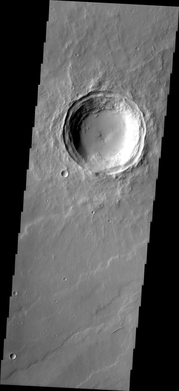
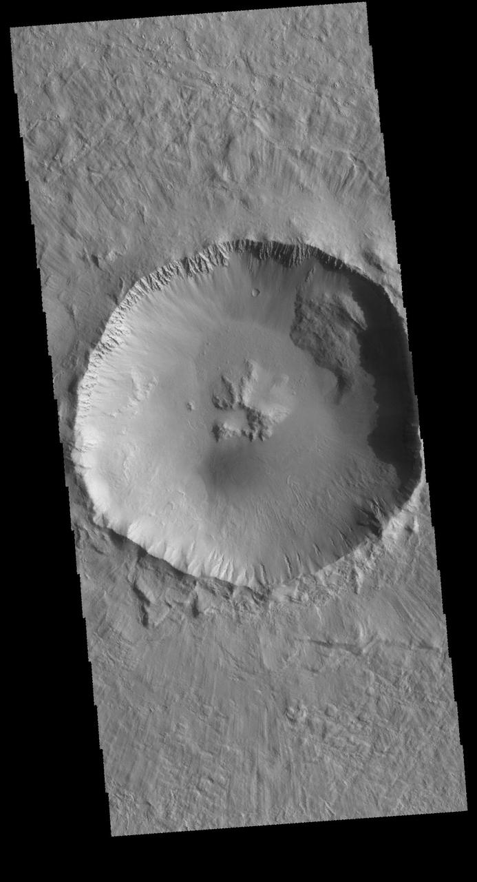
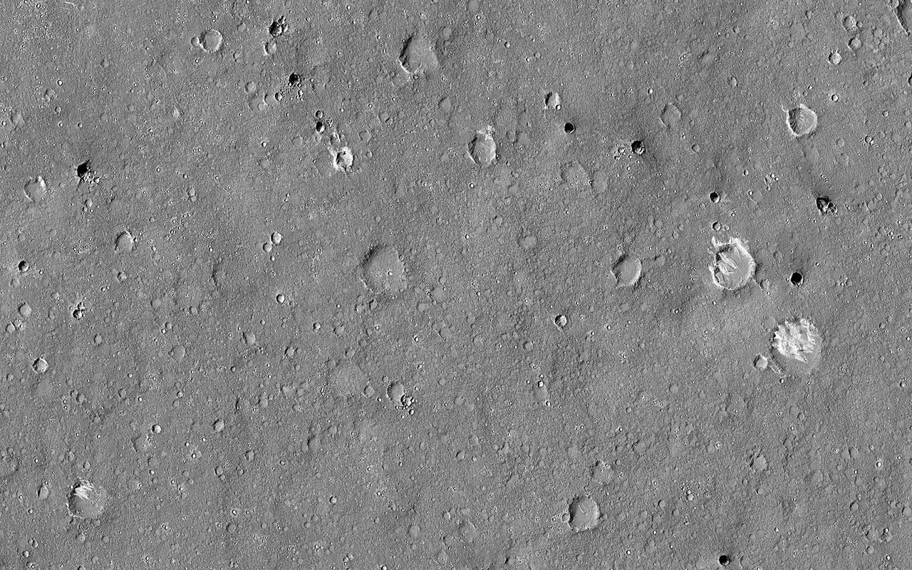
West Elysium Planitia Crater
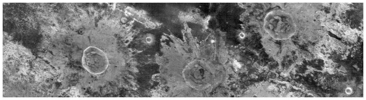
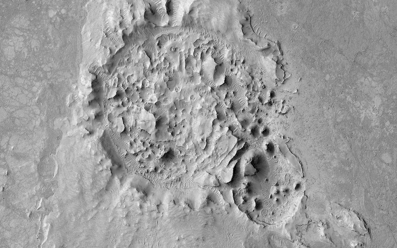
This image from NASA Mars Mars Reconnaissance Orbiter shows a triple impact crater in Elysium Planitia near Tartarus Montes, which probably formed when a binary-or even triple-asteroid struck the surface.
Given enough time, impact craters on Mars tend to fill up with different materials. For instance, some craters on Mars had lakes inside them in the past. When these lakes dried out, they left behind traces of their past existence, such as sedimentary deposits (materials that were carried along with the running water into the lake inside the crater and then settled down). Some craters, especially in high latitudes, contain ice deposits that filled the crater when an earlier ice age allowed ice to extend into the crater's latitude. Here, NASA's Mars Reconnaissance Orbiter spies a crater that lies close to Elysium, a major volcanic system on Mars. The whole region surrounding the crater was at some point covered by lava from the volcano creating vast lava plains, and in the process, flooding impact craters in their way. When the lava eventually cooled down, it solidified and began to shrink in size. This shrinking led to formation of cracks on the surface of the lava that grew in a circular pattern matching the shape of the crater it was filling. Scientists can study these fractures and estimate how much it shrank in volume to better understand the properties of the lava (such as its temperature) during the time it filled the crater. https://photojournal.jpl.nasa.gov/catalog/PIA21596
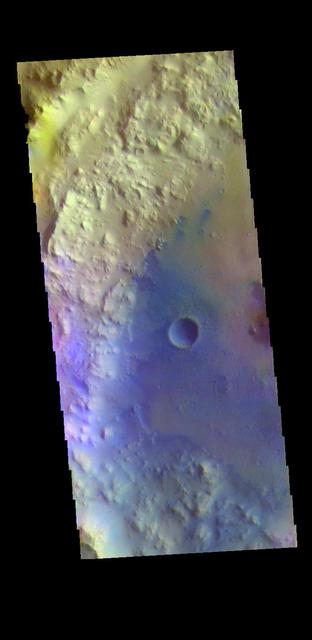
The THEMIS VIS camera contains 5 filters. The data from different filters can be combined in multiple ways to create a false color image. This false color image from NASA 2001 Mars Odyssey spacecraft shows an unnamed crater in Elysium Planitia. Orbit Number: 4951 Latitude: 1.06492 Longitude: 134.035 Instrument: VIS Captured: 2003-01-26 04:19 http://photojournal.jpl.nasa.gov/catalog/PIA19219
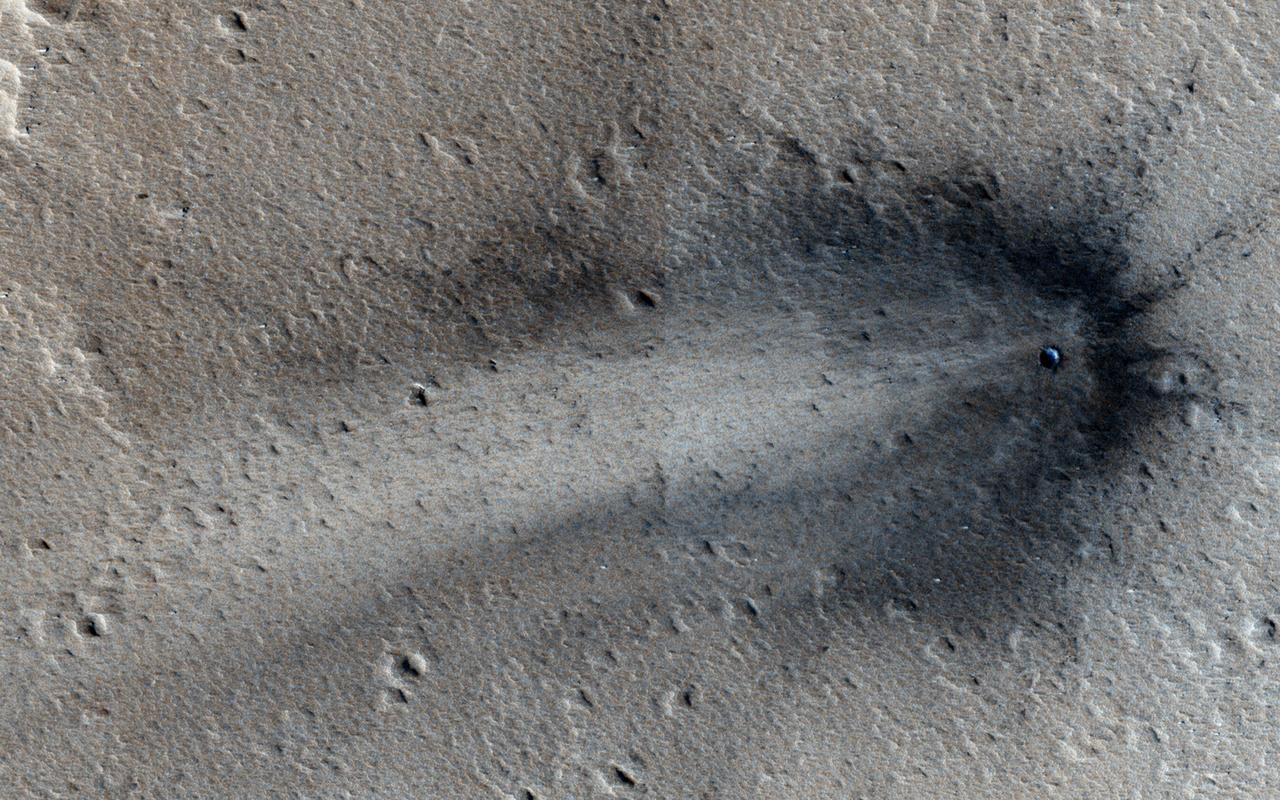
This image from NASA Mars Reconnaissance Orbiter shows a new impact crater in Elysium Planitia.

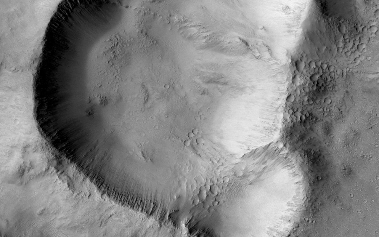
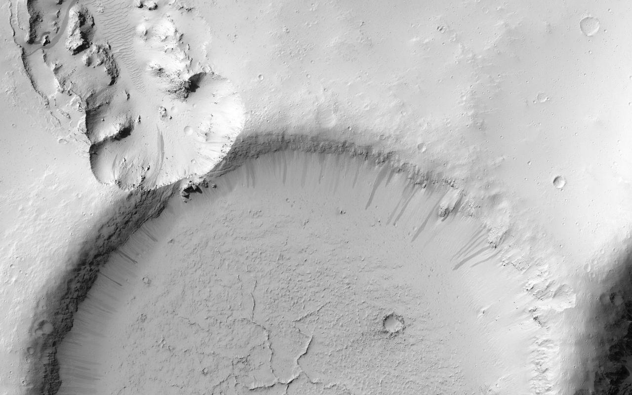
This MOC image shows some a modest-sized meteor impact crater in the Elysium Planitia region of Mars. The dark spot inside the crater is, most likely, a patch of windblown sand and silt
This image from NASA Mars Odyssey is of a doublet crater located in Utopia Planitia, near the Elysium Volcanic region. Doublet craters are formed by simultaneous impact of a meteor that broke into two pieces prior to hitting the surface.
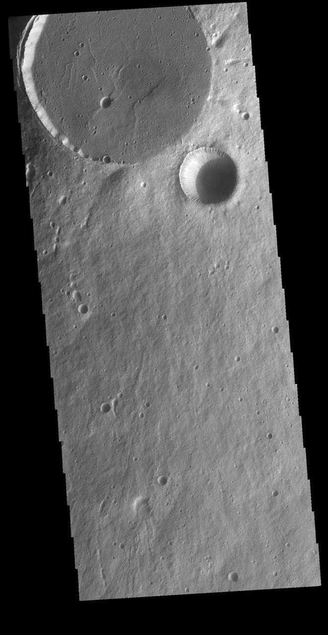
This image captured by NASA 2001 Mars Odyssey spacecraft shows an unnamed crater located northwest of Elysium Mons. This crater contains a central pit, which formed at the time of impact.
This nighttime temperature image from NASA Mars Odyssey spacecraft shows the ancient, heavily cratered surface of the highlands between Isidis and Elysium Planitia.
The lowland plains of Elysium and Utopia Planitiae are separated from the darker heavily cratered highlands by a broad escarpment in this image from NASA's Viking Orbiter 1. http://photojournal.jpl.nasa.gov/catalog/PIA00196
The larger craters in this image from NASA Mars Odyssey spacecraft showing a region north of Elysium Mons are buried and distorted almost beyond recognition. http://photojournal.jpl.nasa.gov/catalog/PIA04007
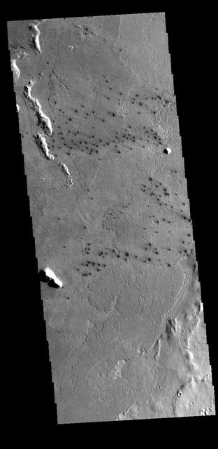
This field of small dark craters is located in southern Elysium Planitia. The dark appearance against the surrounding lava flows suggests that the craters post-date the lava flows. The small "tails" near the craters indicate winds blowing toward the upper left of the image. Orbit Number: 69752 Latitude: 8.2881 Longitude: 157.48 Instrument: VIS Captured: 2017-09-04 10:56 https://photojournal.jpl.nasa.gov/catalog/PIA22361
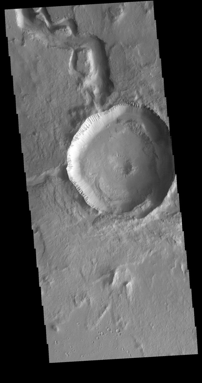
This 2.5-kilometer diameter crater observed by NASA's Mars Reconnaissance Orbiter has been significantly altered from the usual bowl-shaped appearance we associate with craters. Material has covered significant portions of the ejecta and filled in the crater. This fill material has since been subject to erosion -- like boulders weathering out of the slopes -- and the crater rim is also highly irregular. This crater is located in Elysium Planitia, an area dominated by volcanic processes. It is likely that the crater fill material is volcanic in origin, and possible that the rim was etched by lava, either flowing into the crater or spilling over after the crater filled completely. However, there are also signs of erosion by wind, like the parallel ridges in the rim breaches and between high-standing regions of the crater fill. It is likely that the current appearance of this crater is due to a combination of surface processes. https://photojournal.jpl.nasa.gov/catalog/PIA22041
The THEMIS VIS camera contains 5 filters. The data from different filters can be combined in multiple ways to create a false color image. These false color images may reveal subtle variations of the surface not easily identified in a single band image. Today's false color image shows the western half of Tombaugh Crater. Tombaugh Crater is located in Elysium Planitia and is 60km (37 miles) in diameter. Orbit Number: 79320 Latitude: 3.55509 Longitude: 161.686 Instrument: VIS Captured: 2019-11-01 12:40 https://photojournal.jpl.nasa.gov/catalog/PIA24671
This image from NASA's Mars Reconnaissance Orbiter (MRO) shows remarkably young lava flows in Elysium Planitia. There are almost no impact craters over this flow, indicating that it is probably only a few million years old -- practically an infant in geologic time. For more information see https://photojournal.jpl.nasa.gov/catalog/PIA22432

This image from NASA's Mars Reconnaissance Orbiter shows one of millions of small (10s of meters in diameter) craters and their ejecta material that dot the Elysium Planitia region of Mars. The small craters were likely formed when high-speed blocks of rock were thrown out by a much larger impact (about 10-kilometers in diameter) and fell back to the ground. Some of these blocks may actually escape Mars, which is how we get samples in the form of meteorites that fall to Earth. Other ejected blocks have insufficient velocity, or the wrong trajectory, to escape the Red Planet. As such, when one of these high-speed blocks impacts the surface, it makes what is called a "secondary" crater. These secondaries can form dense "chains" or "rays," which are radial to the crater that formed them. https://photojournal.jpl.nasa.gov/catalog/PIA21769
This image NASA Mars Reconnaissance Orbiter shows an impact crater that was cut by lava in the Elysium Planitia region of Mars. It looks relatively flat, with a shallow floor, rough surface texture, and possible cooling cracks seem to indicate that the crater was partially filled with lava. The northern part of the image also shows a more extensive lava flow deposit that surrounds the impact ejecta of the largest impact crater in the image. Which way did the lava flow? It might appear that the lava flowed from the north through the channel into the partially filled crater. However, if you look at the anaglyph with your red and blue 3D glasses, it becomes clear that the partially filled crater sits on top of the large crater's ejecta blanket, making it higher than the lava flow to the north. Since lava does not flow uphill, that means the explanation isn't so simple. http://photojournal.jpl.nasa.gov/catalog/PIA18887
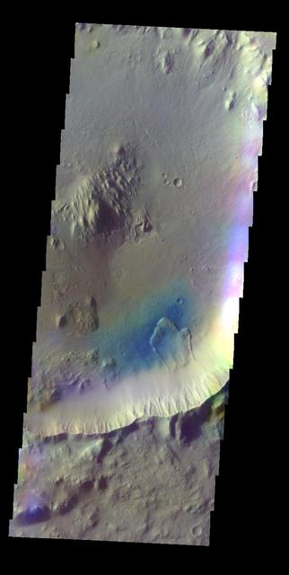
This VIS image shows two circular features. The flat floored feature at the top of the image is the summit caldera of Elysium Mons and was formed by volcanic activity. The bowl-shaped feature next to the caldera is an impact crater. Orbit Number: 65587 Latitude: 24.3248 Longitude: 146.842 Instrument: VIS Captured: 2016-09-26 07:14 http://photojournal.jpl.nasa.gov/catalog/PIA21159
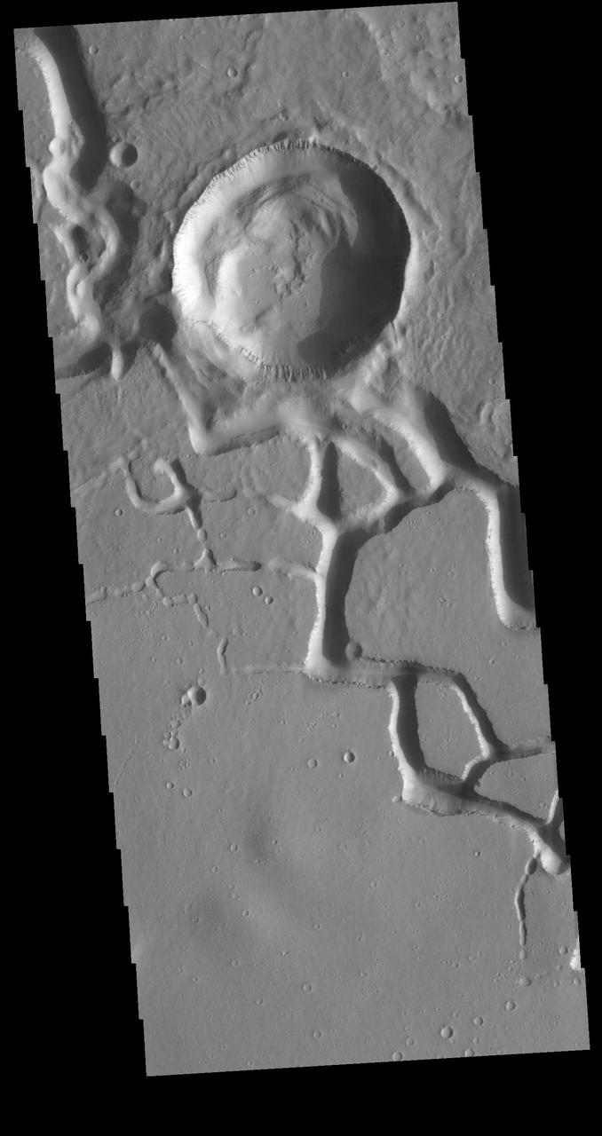
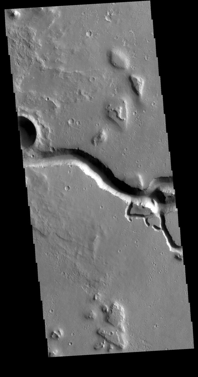
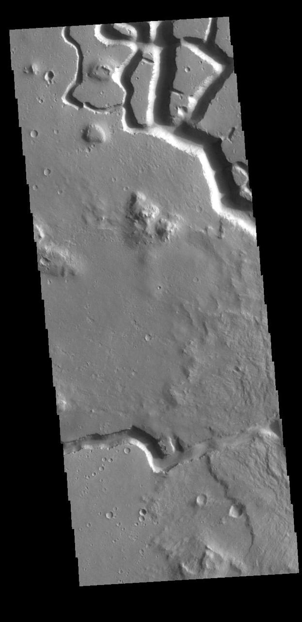
This VIS image is located in the central portion of Hephaestus Fossae. Hephaestus Fossae is a complex channel system in Utopia Planitia near Elysium Mons. It has been proposed that the channel formed by the release of melted subsurface ice during the impact event that created the crater in this image. Additionally, the nearby Elysium volcanic center created subsurface heating that may have played a part in creating both Hephaestus Fossae and Hebrus Valles to the north. Orbit Number: 81193 Latitude: 18.8168 Longitude: 124.985 Instrument: VIS Captured: 2020-04-03 18:04 https://photojournal.jpl.nasa.gov/catalog/PIA23938
This VIS image is located in the central portion of Hephaestus Fossae. Hephaestus Fossae is a complex channel system in Utopia Planitia near Elysium Mons. It has been proposed that the channel formed by the release of melted subsurface ice during the impact event that created a large crater south of this image. Additionally, the nearby Elysium volcanic center created subsurface heating that may have played a part in creating both Hephaestus Fossae and Hebrus Valles to the north. Orbit Number: 79159 Latitude: 19.0493 Longitude: 124.534 Instrument: VIS Captured: 2019-10-19 06:34 https://photojournal.jpl.nasa.gov/catalog/PIA23579
This VIS image is located in the southeastern portion of Hephaestus Fossae. Hephaestus Fossae is a complex channel system in Utopia Planitia near Elysium Mons. It has been proposed that the channel formed by the release of melted subsurface ice during the impact event that created a large crater west of this image. Additionally, the nearby Elysium volcanic center created subsurface heating that may have played a part in creating both Hephaestus Fossae and Hebrus Valles to the north. Hephaestus Fossae are over 600km long (373 miles). Orbit Number: 78847 Latitude: 17.5748 Longitude: 126.158 Instrument: VIS Captured: 2019-09-23 13:59 https://photojournal.jpl.nasa.gov/catalog/PIA23507
This VIS image is located in the central portion of Hephaestus Fossae. Hephaestus Fossae is a complex channel system in Utopia Planitia near Elysium Mons. It has been proposed that the channel formed by the release of melted subsurface ice during the impact event that created a large crater southeast of this image. Additionally, the nearby Elysium volcanic center created subsurface heating that may have played a part in creating both Hephaestus Fossae and Hebrus Valles to the north. Orbit Number: 82079 Latitude: 18.8004 Longitude: 124.5724 Instrument: VIS Captured: 2020-06-15 16:56 https://photojournal.jpl.nasa.gov/catalog/PIA24122
This VIS image is located in the central portion of Hephaestus Fossae. Hephaestus Fossae is a complex channel system in Utopia Planitia near Elysium Mons. It has been proposed that the channel formed by the release of melted subsurface ice during the impact event that created a large crater south of this image. Additionally, the nearby Elysium volcanic center created subsurface heating that may have played a part in creating both Hephaestus Fossae and Hebrus Valles to the north. Orbit Number: 77487 Latitude: 18.8111 Longitude: 124.593 Instrument: VIS Captured: 2019-06-03 14:10 https://photojournal.jpl.nasa.gov/catalog/PIA23335
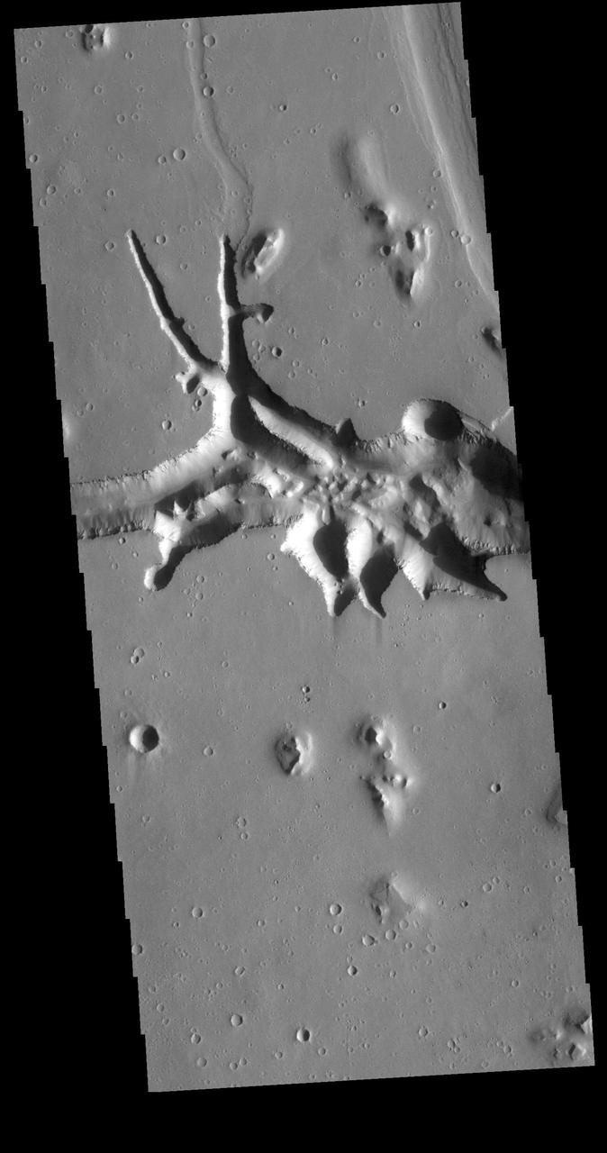
This VIS image shows part of Hephaestus Fossae. Hephaestus Fossae is a complex channel system in Utopia Planitia near Elysium Mons. It has been proposed that the channel formed by the release of melted subsurface ice during the impact event that created the crater just off the left side of the image – only the ejecta is seen in this image. The crater is fairly young, as there is only minimal modification of the crater floor. While it appears that the crater sits of top of the channel, the creation of the crater may have also created the channel. The impact event would have caused subsurface heating, melting any subsurface ice in the region which would have created surface flow to form the channel. Additionally, the nearby Elysium volcanic center created subsurface heating that may have played a part in creating both Hephaestus Fossae and Hebrus Valles to the north. Orbit Number: 94645 Latitude: 17.6141 Longitude: 126.055 Instrument: VIS Captured: 2023-04-16 09:02 https://photojournal.jpl.nasa.gov/catalog/PIA26040
This HiRISE image was taken to sample terrain north of Elysium Planitia and Athabasca Valles. Because HiRISE can only image a small fraction of Mars, most images are targeted on specially selected features of interest. However, we also sample other locations, both to understand the normal terrain and look for things that might not have been obvious enough in other data for anyone to mark out a target. This image caught something interesting. Most of the surface is smooth regolith peppered with small craters. However, some of the craters are notably dark compared with everything else in the image. Zooming in to full resolution shows the reason: the dark craters have small ripples and are dark blue in enhanced color, characteristics usually associated with active sand kicking off its dust cover. Why the sand is moving in these particular craters but not others is not certain but could relate to induration (hardening) of the sand, or the age or topography of the craters. https://photojournal.jpl.nasa.gov/catalog/PIA23427
This image in Athabasca Valles shows lava flows originating from Elysium Mons to the northwest. A Context Camera image shows the lava flowed from the northwest to the southeast, diverting around obstacles as it settled. (The flow is outlined in blue with the flow direction shown in yellow, and the approximate location of the HiRISE image is represented by a white rectangle.) The lava appears to have flowed smoothly around obstructions, almost like water, forming streamlined islands. In the southern part of this image, a branch of the flow diverts around a small crater, and eventually rejoins the main part of the flow. Irregular-shaped ring structures appear on the northern end and are related to the volcanic activity that formed the flows. We also see a dense cluster of secondary craters that formed when material ejected from Corinto Crater (to the northwest) impacted the surface at high speed. At full-resolution, this terrain has the distinctive appearance of a field of numerous, small and closely-spaced craters. https://photojournal.jpl.nasa.gov/catalog/PIA23062
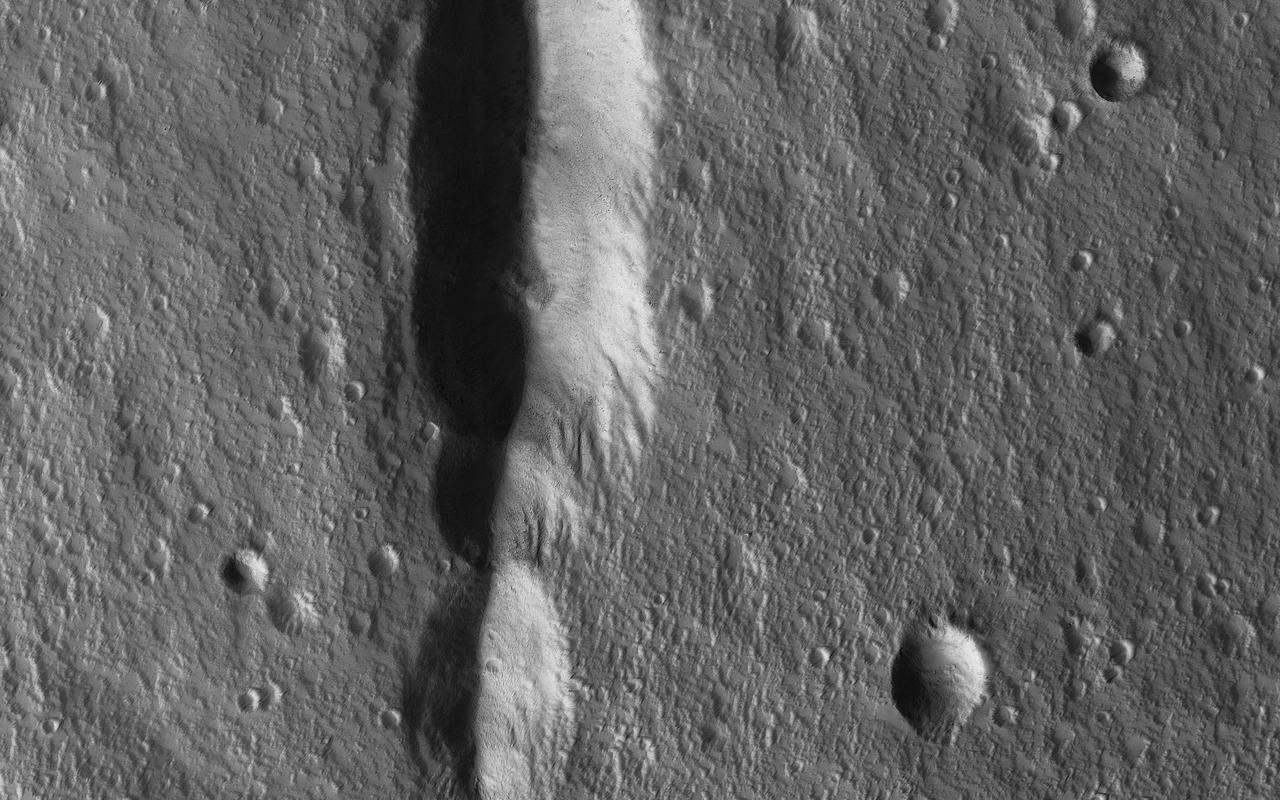
This image shows lava crumpled against the upstream side of an impact crater as seen by NASA Mars Reconnaissance Orbiter.
This VIS image is located at the eastern end of Hephaestus Fossae. Hephaestus Fossae is a channel system in Utopia Planitia near Elysium Mons. It has been proposed that the channel formed by the release of melted subsurface ice during the impact event that created a large crater west of this image. The method of formation for this complex feature at end of the channel is still unknown. Orbit Number: 72659 Latitude: 17.3167 Longitude: 126.988 Instrument: VIS Captured: 2018-05-01 22:42 https://photojournal.jpl.nasa.gov/catalog/PIA22621
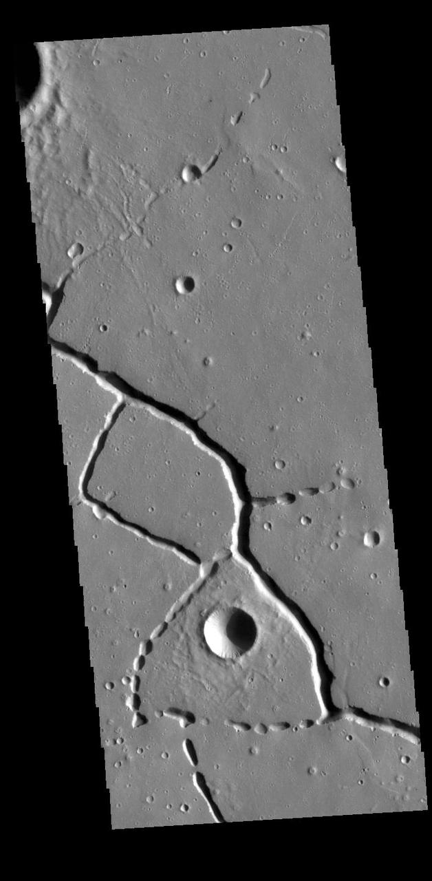
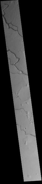
This VIS image is located in the northern portion of Hephaestus Fossae. Hephaestus Fossae is a complex channel system in Utopia Planitia near Elysium Mons. It has been proposed that the channels formed by the release of melted subsurface ice during the impact event that created a large crater southeast of this image. Additionally, the nearby Elysium volcanic center created subsurface heating that may have played a part in creating both Hephaestus Fossae and Hebrus Valles to the north. The right angle intersections indicate there is some tectonic activity in the region, and the circular depressions indicate surface collapse into subsurface voids. Hephaestus Fossae is a very complex set of features. Orbit Number: 88618 Latitude: 22.2991 Longitude: 121.441 Instrument: VIS Captured: 2021-12-06 02:47 https://photojournal.jpl.nasa.gov/catalog/PIA25199
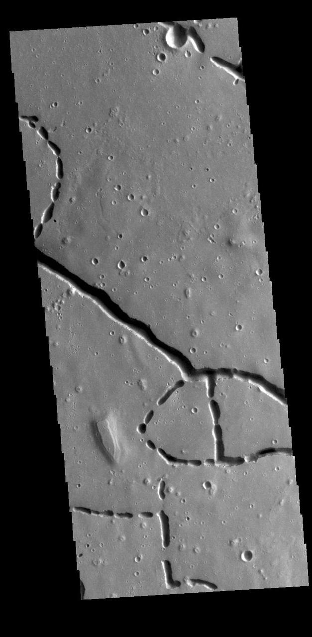
This VIS image is located in the northern portion of Hephaestus Fossae. Hephaestus Fossae is a complex channel system in Utopia Planitia near Elysium Mons. It has been proposed that the channels formed by the release of melted subsurface ice during the impact event that created a large crater southeast of this image. Additionally, the nearby Elysium volcanic center created subsurface heating that may have played a part in creating both Hephaestus Fossae and Hebrus Valles to the north. The right angle intersections indicate there is some tectonic activity in the region, and the circular depressions indicate surface collapse into subsurface voids. Hephaestus Fossae is a very complex set of features. Orbit Number: 85960 Latitude: 21.3916 Longitude: 122.454 Instrument: VIS Captured: 2021-05-01 06:13 https://photojournal.jpl.nasa.gov/catalog/PIA24212
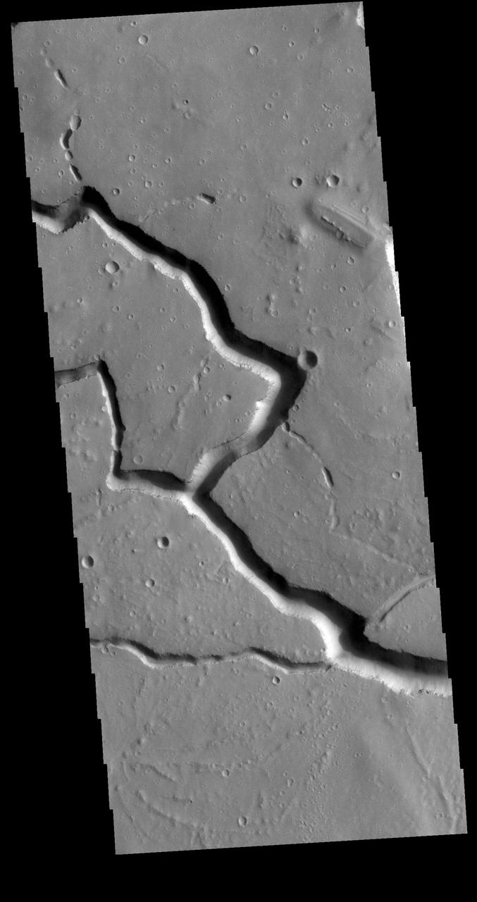
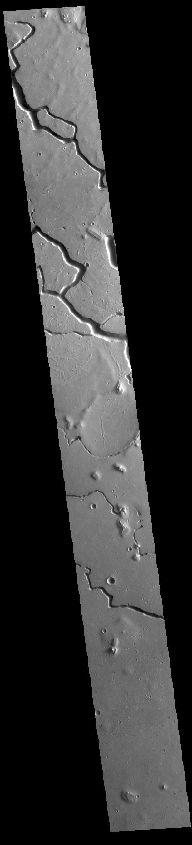
This VIS image is located in the central portion of Hephaestus Fossae. Hephaestus Fossae is a complex channel system in Utopia Planitia near Elysium Mons. It has been proposed that the channel formed by the release of melted subsurface ice during the impact event that created a large crater south of this image. Additionally, the nearby Elysium volcanic center created subsurface heating that may have played a part in creating both Hephaestus Fossae and Hebrus Valles to the north. Since many of the channels have right angle intersections, tectonic forces may also have played a part in the formation of this system. In fact, the entire feature is called a 'fossae' rather than a 'vallis', recognizing the dual forces of tectonic stresses and fluid flow. The entire system is approximately 605km long (375 miles). Orbit Number: 79446 Latitude: 19.3029 Longitude: 124.484 Instrument: VIS Captured: 2019-11-11 21:45 https://photojournal.jpl.nasa.gov/catalog/PIA23661
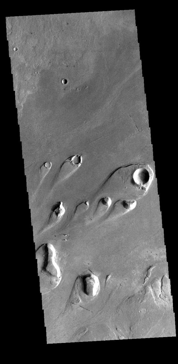
Today's VIS image shows part of Athabasca Valles. Multiple streamlined islands are seen in this image. The teardrop shaped features were formed by liquid flow deflected around features such as craters and hills. The 'tail' of the island points downstream. The source of the fluid was likely an outburst of groundwater, perhaps related to the Elysium volcanic complex located to the northwest of this image. Arising from Cerberus Fossae, the formation mode of this channel is still being debated. While the channel features are similar to water flow, other features are similar to lava flows, and yet other features have an appearance of slabs of material that floated on an underlying fluid. It is thought that Athabasca Valles is the youngest outflow channel system on Mars. Athabasca Valles is just one of the complex channel formations in the Elysium Planitia region. Orbit Number: 89977 Latitude: 9.44823 Longitude: 156.138 Instrument: VIS Captured: 2022-03-28 00:21 https://photojournal.jpl.nasa.gov/catalog/PIA25466
This VIS image is located in the northern portion of Hephaestus Fossae. Hephaestus Fossae is a complex channel system in Utopia Planitia near Elysium Mons. It has been proposed that the channels formed by the release of melted subsurface ice during the impact event that created a large crater southeast of this image. Additionally, the nearby Elysium volcanic center created subsurface heating that may have played a part in creating both Hephaestus Fossae and Hebrus Valles to the north. The right angle intersections indicate there is some tectonic activity in the region, and the circular depressions indicate surface collapse into subsurface voids. Hephaestus Fossae is a very complex set of features. Orbit Number: 88019 Latitude: 21.1587 Longitude: 122.646 Instrument: VIS Captured: 2021-10-17 19:02 https://photojournal.jpl.nasa.gov/catalog/PIA25111
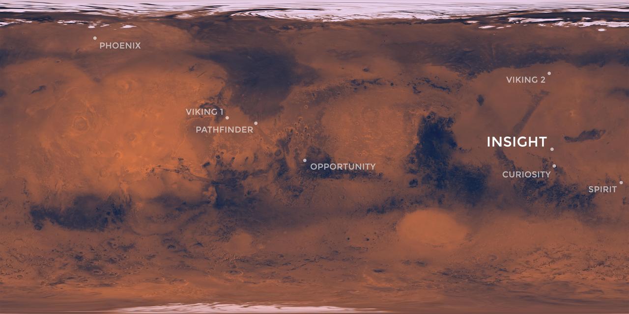
Elysium Planitia, a flat-smooth plain just north of the equator makes for the perfect location from which to study the deep Martian interior. Interior Exploration using Seismic Investigations, Geodesy and Heat Transport, or InSight, is designed to study the deep interior of Mars. The mission seeks the fingerprints of the processes that formed the rocky planets of the solar system. Its landing site, Elysium Planitia, was picked from 22 candidates, and is centered at about 4.5 degrees north latitude and 135.9 degrees east longitude; about 373 miles (600 kilometers) from Curiosity's landing site, Gale Crater. The locations of other Mars landers and rovers are labeled. InSight's scientific success and safe landing depends on landing in a relatively flat area, with an elevation low enough to have sufficient atmosphere above the site for a safe landing. It also depends on landing in an area where rocks are few in number. Elysium Planitia has just the right surface for the instruments to be able to probe the deep interior, and its proximity to the equator ensures that the solar-powered lander is exposed to plenty of sunlight. https://photojournal.jpl.nasa.gov/catalog/PIA22232
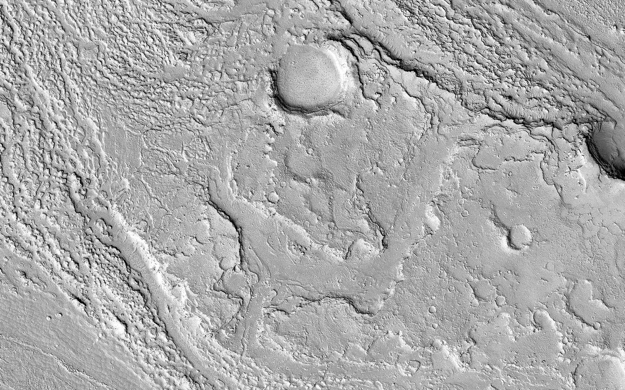
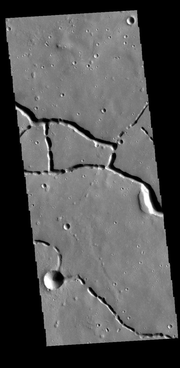
This image is located along the margin between Terra Cimmeria and Elysium Planitia. This boundary region is typified by tectonic fractures forming long, linear depressions. The crater in the lower half of the image has a hexagon shape rather than the normal circular outline. The regional surface/subsurface fracture system deflected the impact generated pressure waves along the tectonic network, causing the linear sides we see in the image. Meteor Crater in northern Arizona has a similar flat sided shape, in that case a square rather than a hexagon. The Arizona crater impacted into sandstone and limestone that had a right angle fracture system. Orbit Number: 78210 Latitude: -7.13006 Longitude: 147.811 Instrument: VIS Captured: 2019-08-02 02:56 https://photojournal.jpl.nasa.gov/catalog/PIA23448
This VIS image shows part of Hephaestus Fossae. Hephaestus Fossae is a complex channel system in Utopia Planitia near Elysium Mons. It has been proposed that the channel formed by the release of melted subsurface ice during the impact event that created the crater just off the bottom right of the image – only the ejecta is seen in this image. The crater is fairly young, as there is only minimal modification of the crater floor. While it appears that the crater sits of top of the channel, the creation of the crater may have also created the channel. The impact event would have caused subsurface heating, melting any subsurface ice in the region which would have created surface flow to form the channel. Additionally, the nearby Elysium volcanic center created subsurface heating that may have played a part in creating both Hephaestus Fossae and Hebrus Valles to the north. The THEMIS VIS camera is capable of capturing color images of the Martian surface using five different color filters. In this mode of operation, the spatial resolution and coverage of the image must be reduced to accommodate the additional data volume produced from using multiple filters. To make a color image, three of the five filter images (each in grayscale) are selected. Each is contrast enhanced and then converted to a red, green, or blue intensity image. These three images are then combined to produce a full color, single image. Because the THEMIS color filters don't span the full range of colors seen by the human eye, a color THEMIS image does not represent true color. Also, because each single-filter image is contrast enhanced before inclusion in the three-color image, the apparent color variation of the scene is exaggerated. Nevertheless, the color variation that does appear is representative of some change in color, however subtle, in the actual scene. Note that the long edges of THEMIS color images typically contain color artifacts that do not represent surface variation. Orbit Number: 86796 Latitude: 17.9392 Longitude: 125.437 Instrument: VIS Captured: 2021-07-09 02:13 https://photojournal.jpl.nasa.gov/catalog/PIA24995
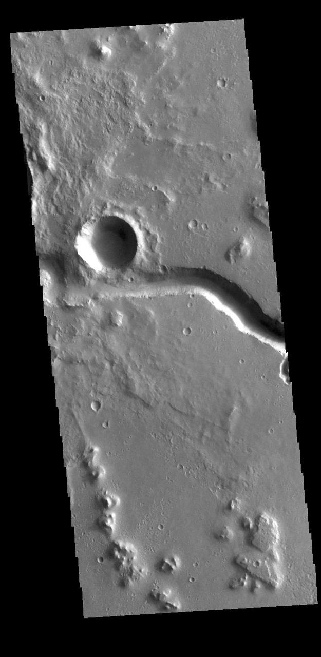
This VIS image is located in Utopia Planitia and shows part of Hephaestus Fossae. Hephaestus Fossae is a complex channel system. It has been proposed that the channel formed by the release of melted subsurface ice during the impact event that created a large crater in the center of this image. Additionally, the nearby Elysium volcanic center created subsurface heating that may have played a part in creating both Hephaestus Fossae and Hebrus Valles to the north. Orbit Number: 81767 Latitude: 17.6969 Longitude: 125.709 Instrument: VIS Captured: 2020-05-21 00:22 https://photojournal.jpl.nasa.gov/catalog/PIA24014
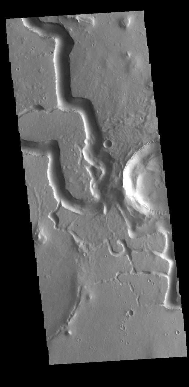
This VIS image is located in Utopia Planitia and shows part of Hephaestus Fossae. Hephaestus Fossae is a complex channel system. It has been proposed that the channel formed by the release of melted subsurface ice during an impact event that created a large crater south of this image. Additionally, the nearby Elysium volcanic center created subsurface heating that may have played a part in creating both Hephaestus Fossae and Hebrus Valles to the north. Orbit Number: 85623 Latitude: 19.0345 Longitude: 124.821 Instrument: VIS Captured: 2021-04-03 12:15 https://photojournal.jpl.nasa.gov/catalog/PIA24858
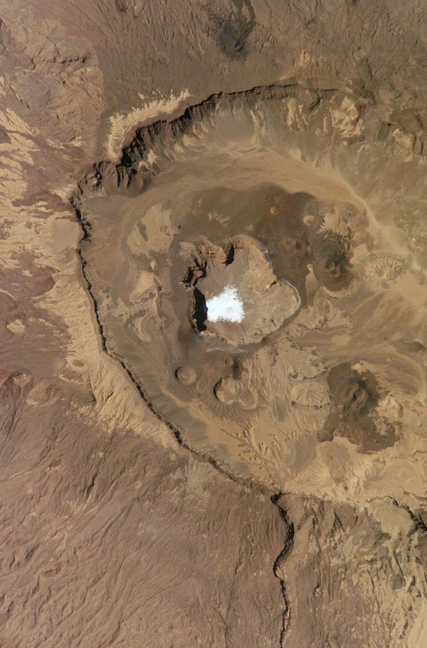
This is a view of the Emi Koussi Caldera captured by the Expedition Six Crew Observation (CEO) experiment aboard the International Space Station (ISS). Rising 2.3 km above the surrounding sandstone plains, Emi Koussi is a 6.5 km wide volcano located at the south end of the Tibesti Mountains in the central Sahara desert. The volcano is one of several in the Tibesti massif and has been used as a close analog to the famous Martian volcano Elysium Mons. Major charnels can be seen on volcanoes on both planets that indicate low points in caldera rims where lava spilled out of the pre-collapsed craters.
Hebrus Valles are a complex set of channels in the northern lowlands of Mars just to the west of the Elysium volcanic region. The channel segments to the north of this image display a variety of features, including streamlined forms and terracing that are suggestive of catastrophic flooding. However, this observation shows channels of uniform width suggesting more persistent flows eroding into and around two impact craters, each about two hundred meters in diameter. This complex geology may be the result of formation in volcanic terrains as fluid flows erode into basalt and interbedded ash or sediment layers. The channel system is thought to be early Amazonian in age (as far back as 3 billion years ago), which is younger than many of the other outflow channels on Mars. https://photojournal.jpl.nasa.gov/catalog/PIA25359
During the 2018 Mars dust storm, we obtained a clear view of the summit of the giant volcano Elysium Mons. We see the western rim and floor of the caldera, and a chain of pits (called a "catena") extending from the caldera towards the north. The chain of pits likely formed by volcanic processes, such as the collapse of a lava tube after it drained. Or by a tectonic process, such as a rift in the rocks below that drained loose material from the surface. An unexpected feature of this catena is the presence of avalanches in two of the pits (marked A and B in the cutout, with the uphill direction towards the top of the image.) The flows in both pits could be ancient, produced during the formation of the catena, but they are not found in the other pits in the chain. They might have formed more recently by the collapse of steep dust deposits like those in a degraded crater to the left of the catena. https://photojournal.jpl.nasa.gov/catalog/PIA22728

This image shows a bright, rectangular-looking landform surrounded by a dark floor. How did this feature get here if it looks so different than its surroundings? The feature resembles a plateau. Dark streaks mark steep slopes on its sides while the top appears flat. The slope streaks are not all the same age, as we see a variation in colors from faint to dark. Craters in a variety of sizes and ages pepper the entire rectangle, but the dark, textured floor has very few noticeable craters. The evidence suggests that this rectangular feature is a high-standing "island" of older land surrounded by one or more younger lava flows. This landmass is located in Amazonis Planitia, a smooth plains area potentially formed by large-scale lava floods between the Tharsis and Elysium volcanic regions. As lava flowed into this area, the rectangular plateau was too high to cover completely, leaving a bright spot sticking out of the dark basalt floor for us to find. https://photojournal.jpl.nasa.gov/catalog/PIA22725
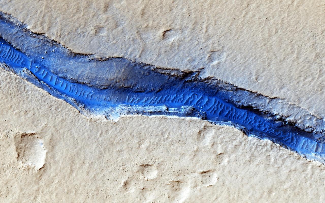
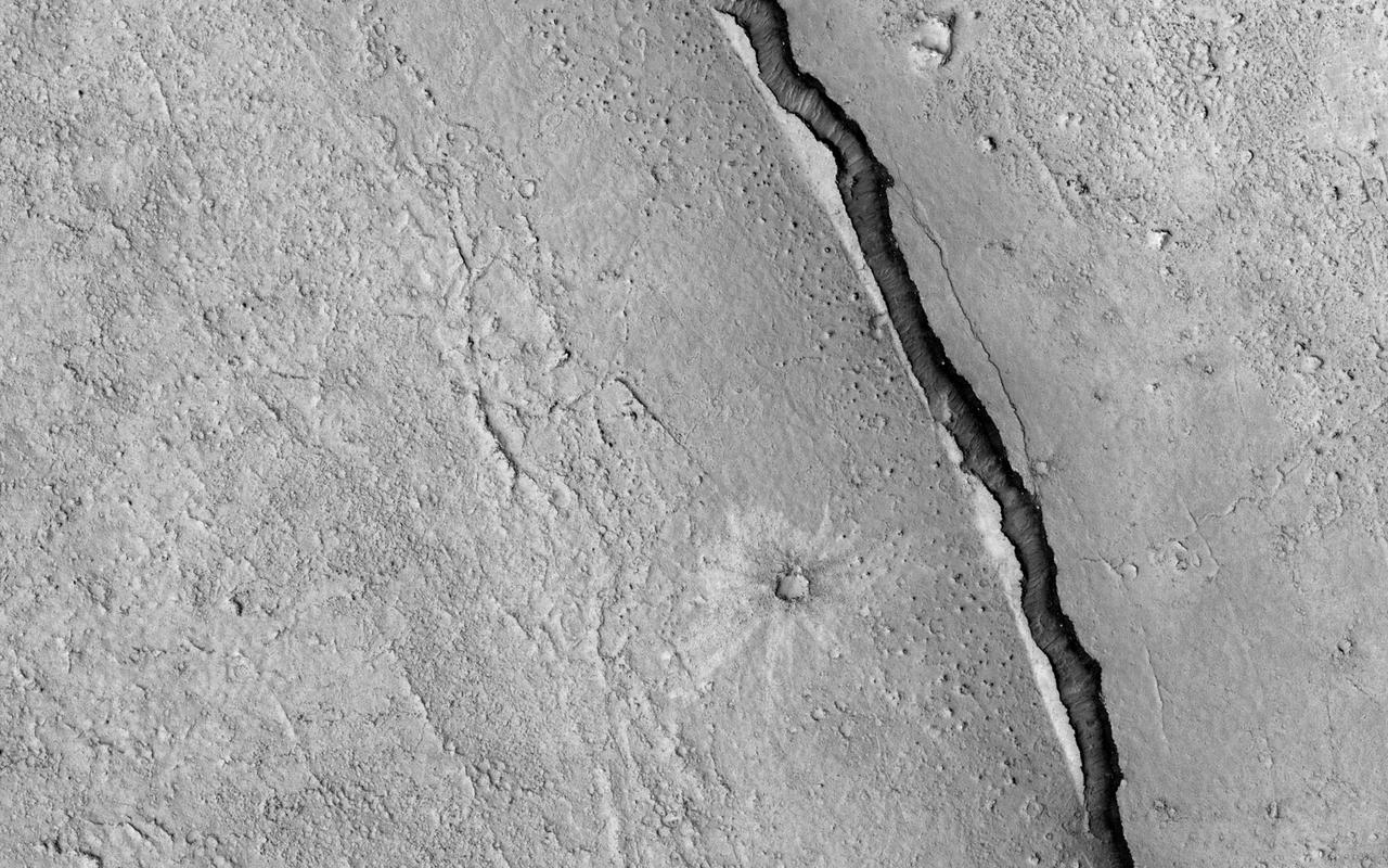
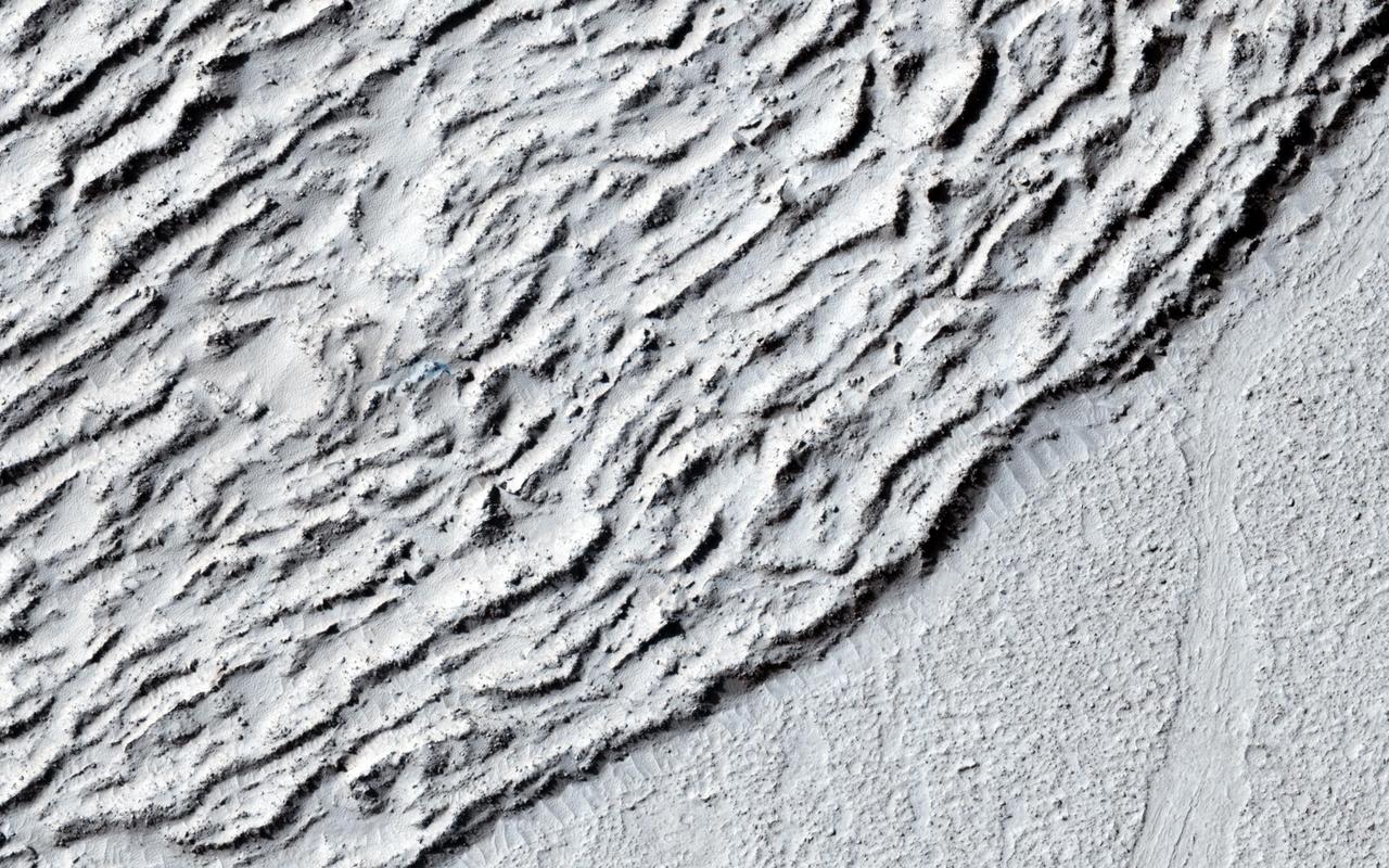
A dominant driver of surface processes on Mars today is aeolian (wind) activity. In many cases, sediment from this activity is trapped in low-lying areas, such as craters. Aeolian features in the form of dunes and ripples can occur in many places on Mars depending upon regional wind regimes. The Cerberus Fossae are a series of discontinuous fissures along dusty plains in the southeastern region of Elysium Planitia. This rift zone is thought to be the result of combined volcano-tectonic processes. Dark sediment has accumulated in areas along the floor of these fissures as well as inactive ripple-like aeolian bedforms known as "transverse aeolian ridges" (TAR). Viewed through HiRISE infrared color, the basaltic sand lining the fissures' floor stands out as deep blue against the light-toned dust covering the region. This, along with the linearity of the fissures and the wave-like appearance of the TAR, give the viewer an impression of a river cutting through the Martian plains. However, this river of sand does not appear to be flowing. Analyses of annual monitoring images of this region have not detected aeolian activity in the form of ripple migration thus far. http://photojournal.jpl.nasa.gov/catalog/PIA21063