Empty Quarter - February 1st, 20003 Description: White pinpricks of cloud cast ebony shadows on the Rub' al Khali, or Empty Quarter, near the border between Saudi Arabia and Yemen. The lines of wind-sculpted sand are characteristic of immense sand deserts, or sand seas, and the Rub' al Khali is the largest desert of this type in the world. A highland ridge is just high enough to disturb the flow of the lines. In the center of that interruption lies the Saudi Arabian town of Sharurah. Credit: USGS/NASA/Landsat 7 To learn more about the Landsat satellite go to: <a href="http://landsat.gsfc.nasa.gov/" rel="nofollow">landsat.gsfc.nasa.gov/</a> <b><a href="http://www.nasa.gov/centers/goddard/home/index.html" rel="nofollow">NASA Goddard Space Flight Center</a></b> enables NASA’s mission through four scientific endeavors: Earth Science, Heliophysics, Solar System Exploration, and Astrophysics. Goddard plays a leading role in NASA’s accomplishments by contributing compelling scientific knowledge to advance the Agency’s mission. <b>Follow us on <a href="http://twitter.com/NASA_GoddardPix" rel="nofollow">Twitter</a></b> <b>Join us on <a href="http://www.facebook.com/pages/Greenbelt-MD/NASA-Goddard/395013845897?ref=tsd" rel="nofollow">Facebook</a></b>
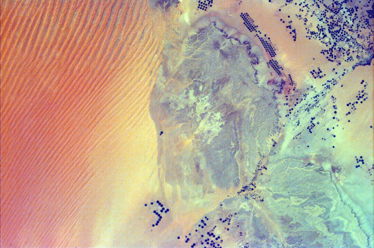
This image from NASA EarthKAM shows pivot irrigation near the city of As Sulayyil Sulayel, Saudi Arabia. The edge of the Rub al-Khali or Empty Quarter is visible in the southeast.
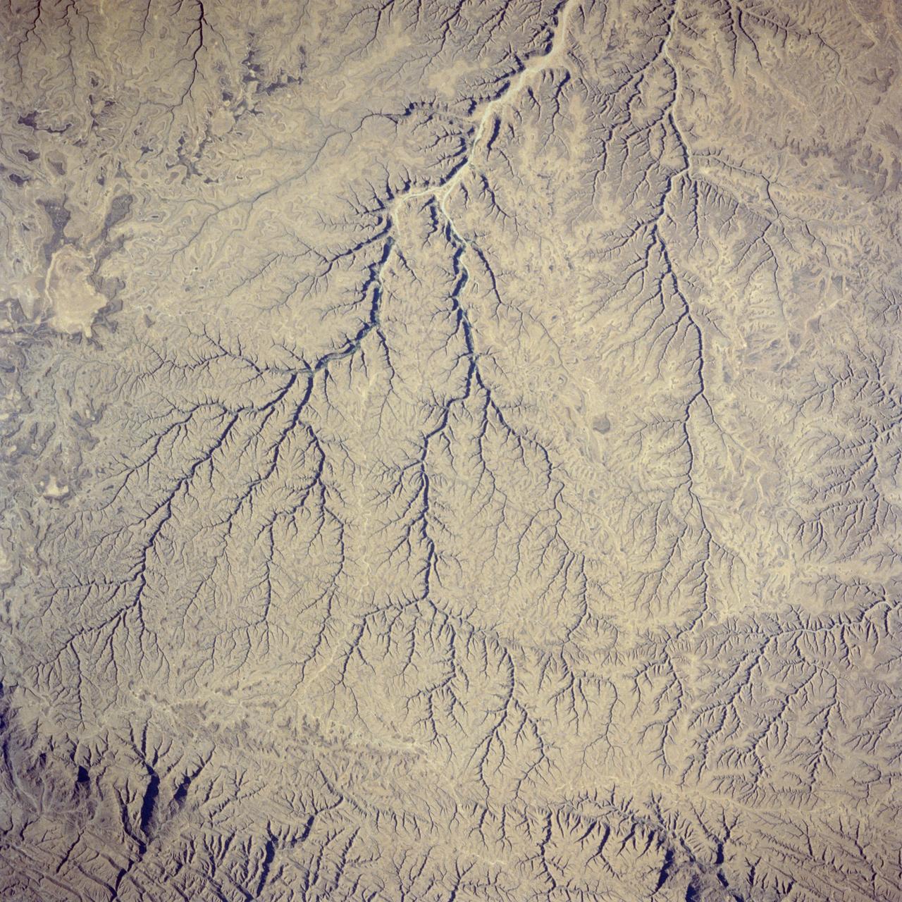
41G-36-036 (5-13 Oct 1984) --- The deeply etched patterns of intermittent streams in the Hadhramaut Plateau of south Yemen. These stream beds, which now rarely carry water, are deeply entrenched, owing to the geologically recent uplift of the plateau. nonetheless, a very distinct watercourse appears along the top and bottom edges of the photograph. In the photograph's upper portion, available water will flow into the vast emptiness of the Rub al Khali (Empty Quarter). In the lower portion, water will flow to the Gulf of Aden.
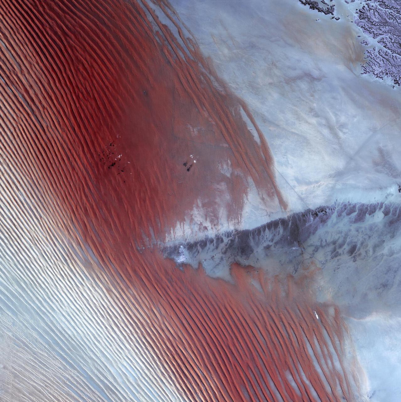
This image of Saudi Arabia shows a great sea of linear dunes in part of the Rub' al Khali, or the Empty Quarter. Acquired on June 25, 2000, the image covers an area 37 kilometers (23 miles) wide and 28 kilometers (17 miles) long in three bands of the reflected visible and infrared wavelength region. The dunes are yellow due to the presence of iron oxide minerals. The inter-dune area is made up of clays and silt and appears blue due to its high reflectance in band 1. The Rub' al Khali is the world's largest continuous sand desert. It covers about 650,000 square kilometers (250,966 square miles) and lies mainly in southern Saudi Arabia, though it does extend into the United Arab Emirates, Oman, and Yemen. One of the world's driest areas, it is uninhabited except for the Bedouin nomads who cross it. The first European to travel through the desert was Bertram Thomas in 1930. http://photojournal.jpl.nasa.gov/catalog/PIA02656
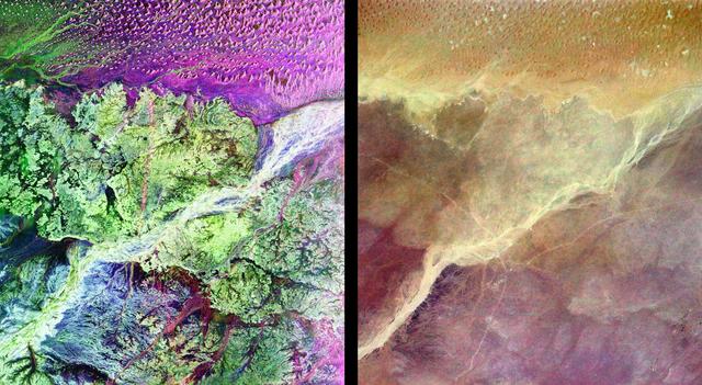
This pair of images from space shows a portion of the southern Empty Quarter of the Arabian Peninsula in the country of Oman. On the left is a radar image of the region around the site of the fabled Lost City of Ubar, discovered in 1992 with the aid of remote sensing data. On the right is an enhanced optical image taken by the shuttle astronauts. Ubar existed from about 2800 BC to about 300 AD. and was a remote desert outpost where caravans were assembled for the transport of frankincense across the desert. The actual site of the fortress of the Lost City of Ubar, currently under excavation, is too small to show in either image. However, tracks leading to the site, and surrounding tracks, show as prominent, but diffuse, reddish streaks in the radar image. Although used in modern times, field investigations show many of these tracks were in use in ancient times as well. Mapping of these tracks on regional remote sensing images provided by the Landsat satellite was a key to recognizing the site as Ubar. The prominent magenta colored area is a region of large sand dunes. The green areas are limestone rocks, which form a rocky desert floor. A major wadi, or dry stream bed, runs across the scene and appears as a white line. The radar images, and ongoing field investigations, will help shed light on an early civilization about which little in known. The radar image was taken by the Spaceborne Imaging Radar C/X-Band Synthetic Aperture Radar (SIR-C/X-SAR) and is centered at 18 degrees North latitude and 53 degrees East longitude. The image covers an area about 50 kilometers by 100 kilometers (31 miles by 62 miles). The colors in the image are assigned to different frequencies and polarizations of the radar as follows: red is L-band, horizontally transmitted, horizontally received; blue is C-band horizontally transmitted, horizontally received; green is L-band horizontally transmitted, vertically received. SIR-C/X-SAR, a joint mission of the German, Italian and the United States space agencies, is part of NASA's Mission to Planet Earth. http://photojournal.jpl.nasa.gov/catalog/PIA01302
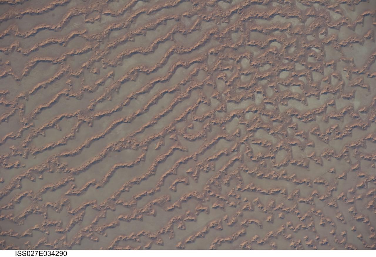
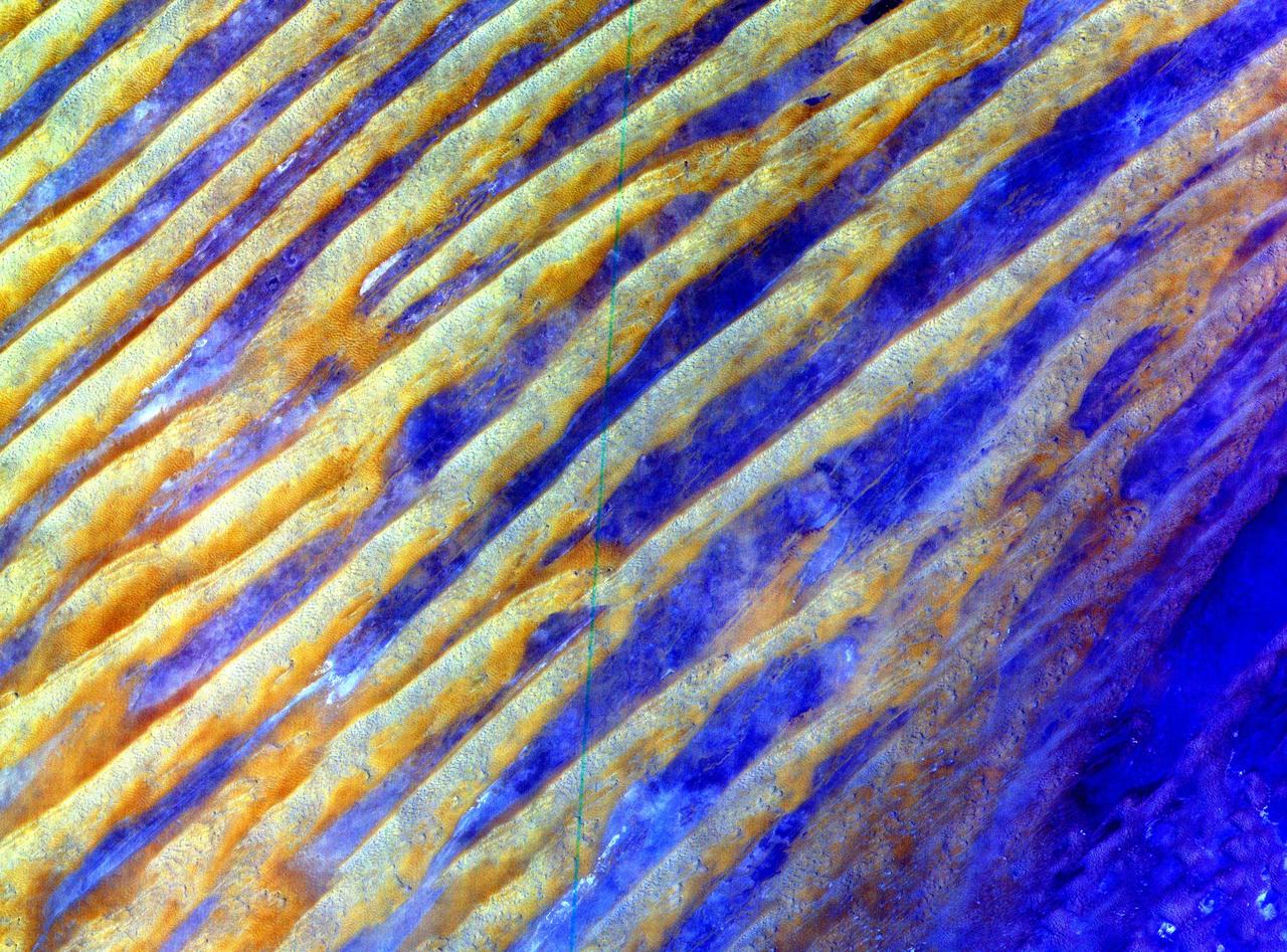
ISS027-E-034290 (16 May 2011) --- Ar Rub al Khali Sand Sea, Arabian Peninsula is featured in this image photographed by an Expedition 27 crew member on the International Space Station. The Ar Rub al Khali, also known as the “Empty Quarter”, is a large region of sand dunes and interdune flats known as a sand sea (or erg). This photograph highlights a part of the Ar Rub al Khali located close to its southeastern margin in the Sultanate of Oman. Reddish-brown, large linear sand dunes alternate with blue-gray interdune salt flats known as sabkhas at left. The major trend of the linear dunes is transverse to northwesterly trade winds that originate in Iraq (known as the Shamal winds). Formation of secondary barchan (crescent-shaped) and star dunes (dune crests in several directions originating from a single point, looking somewhat like a starfish from above) on the linear dunes is supported by southwesterly winds that occur during the monsoon season (Kharif winds). The long linear dunes begin to break up into isolated large star dunes to the northeast and east (right). This is likely a result of both wind pattern interactions and changes in the sand supply to the dunes. The Empty Quarter covers much of the south-central portion of the Arabian Peninsula, and with an area of approximately 660,000 square kilometers it is the largest continuous sand desert on Earth. The Empty Quarter is so called as the dominantly hyperarid climate and difficulty of travel through the dunes has not encouraged permanent settlement within the region. There is geological and archeological evidence to support cooler and wetter past climates in the region together with human settlement. This evidence includes exposed lakebed sediments, scattered stone tools, and the fossils of hippopotamus, water buffalo, and long-horned cattle.
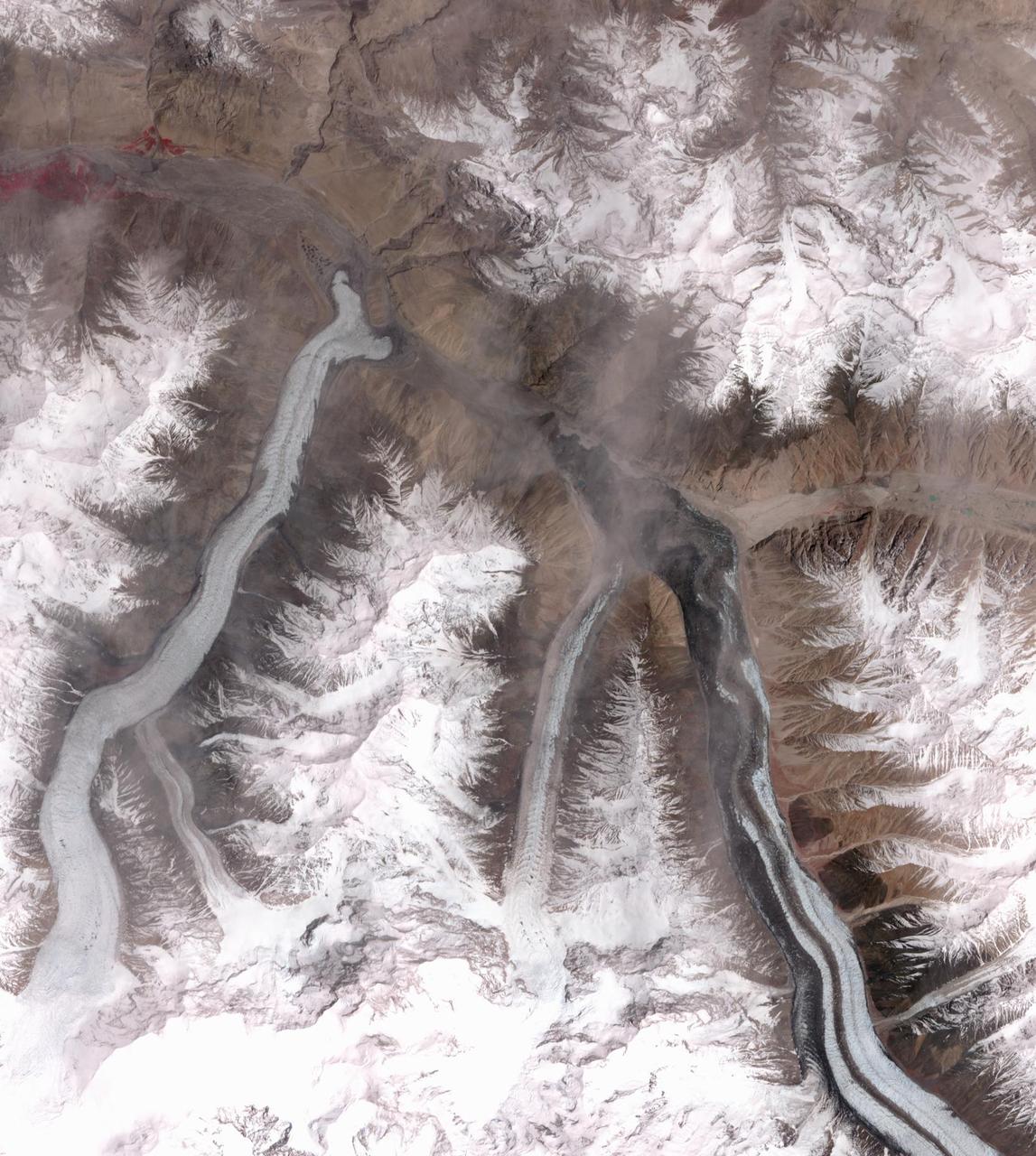
In October 2016, the Khurdopin Glacier in Pakistan began a rapid surge after 20 years of little movement. By March, 2017, a large lake had formed in the Shimshal River, where the glacier had formed a dam. Fortunately, the river carved an outlet through the glacier before the lake could empty catastrophically. In this pair of ASTER images, acquired August 20, 2015 and May 21, 2017, the advance of the Khurdopin Glacier (dark gray and white "river" in lower right quarter of image) is obvious by comparing the before and after images. The images cover an area of 25 by 27.8 km, and are located at 36.3 degrees north, 75.5 degrees east. https://photojournal.jpl.nasa.gov/catalog/PIA22304
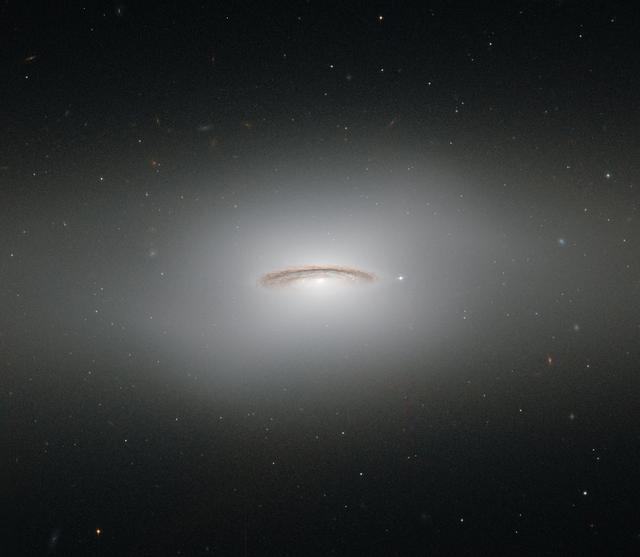
This neat little galaxy is known as NGC 4526. Its dark lanes of dust and bright diffuse glow make the galaxy appear to hang like a halo in the emptiness of space in this image from the NASA/ESA Hubble Space Telescope. Although this image paints a picture of serenity, the galaxy is anything but. It is one of the brightest lenticular galaxies known, a category that lies somewhere between spirals and ellipticals. It has hosted two known supernova explosions, one in 1969 and another in 1994, and is known to have a colossal supermassive black hole at its center that has the mass of 450 million suns. NGC 4526 is part of the Virgo cluster of galaxies. Ground-based observations of galaxies in this cluster have revealed that a quarter of these galaxies seem to have rapidly rotating disks of gas at their centers. The most spectacular of these is this galaxy, NGC 4526, and its spinning disk of gas, dust, and stars reaches out uniquely far from its heart, spanning some seven percent of the galaxy's entire radius. This disk is moving incredibly fast, spinning at more than 250 kilometers per second. The dynamics of this quickly whirling region were actually used to infer the mass of NGC 4526’s central black hole — a technique that had not been used before to constrain a galaxy’s central black hole. This image was taken with Hubble's Wide Field and Planetary Camera 2 and the Advanced Camera for Surveys. Credit: ESA/Hubble & NASA, Acknowledgement: Judy Schmidt