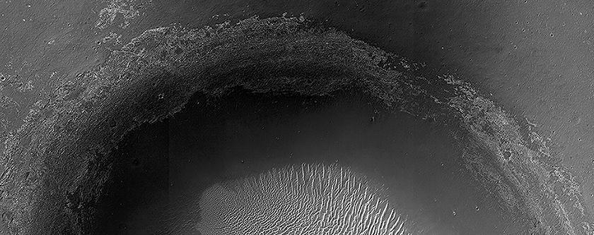
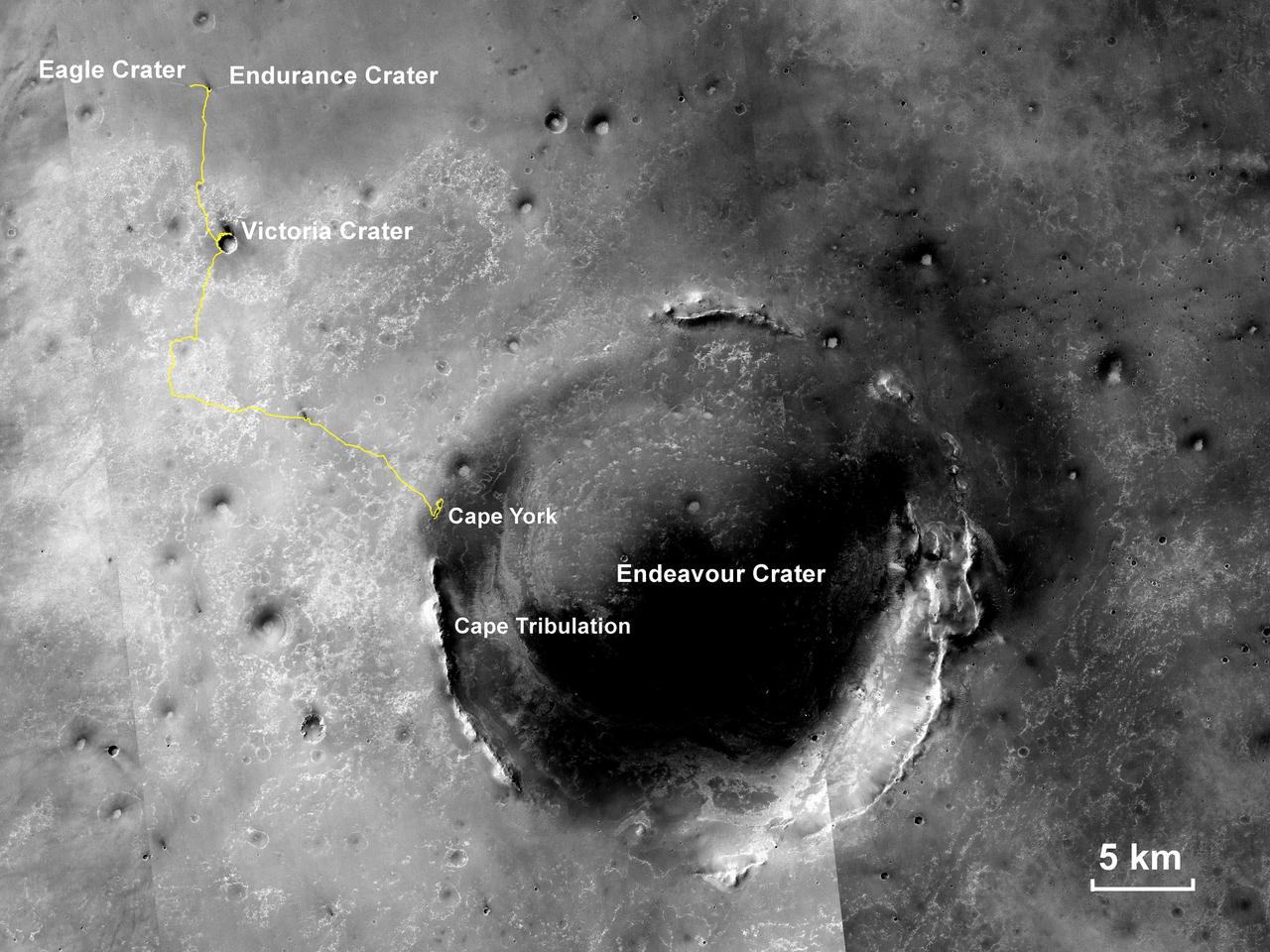
Endeavour Crater in Context
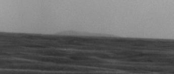
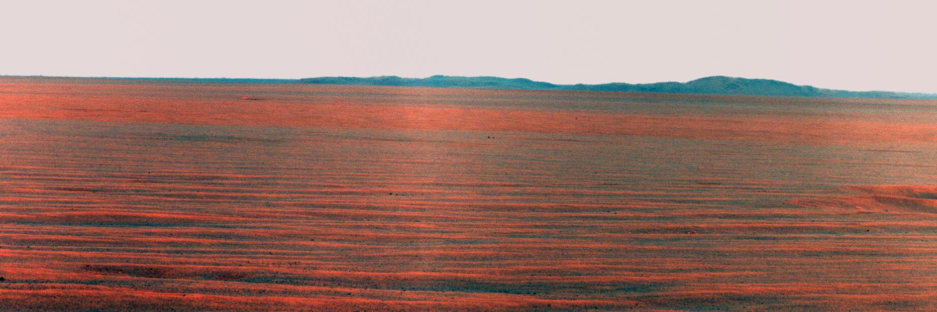
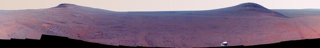
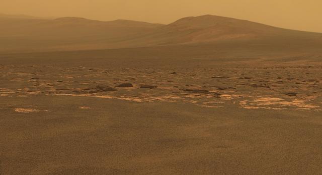
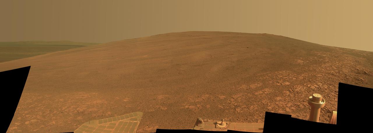
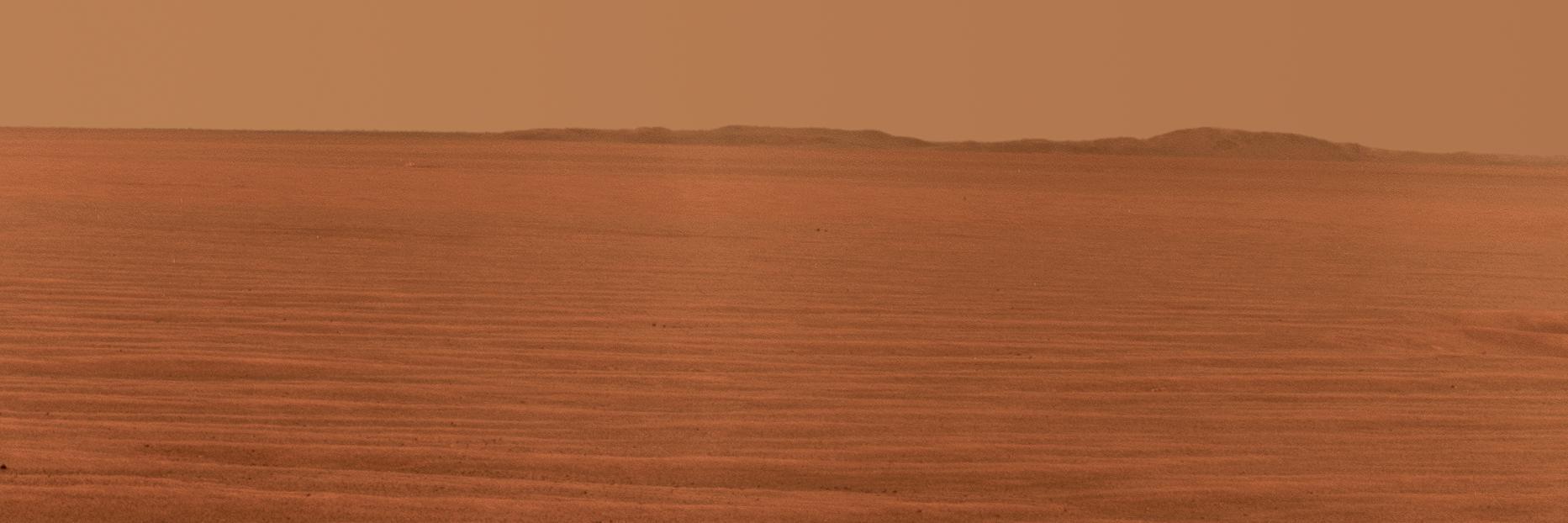
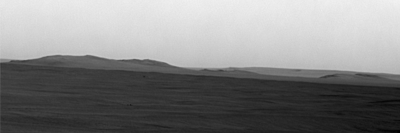
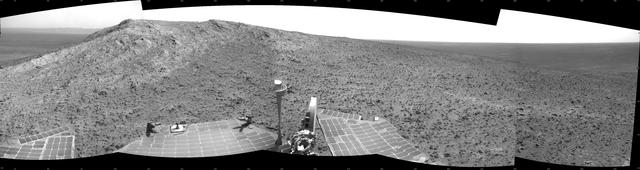
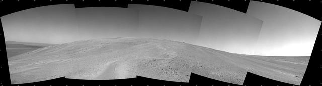
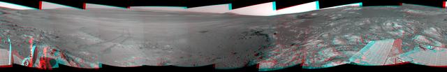
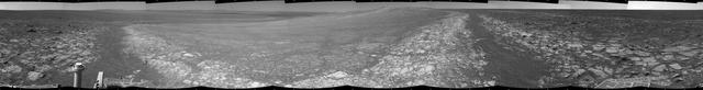
East Rim of Endeavour Crater on Horizon
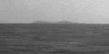
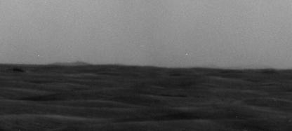
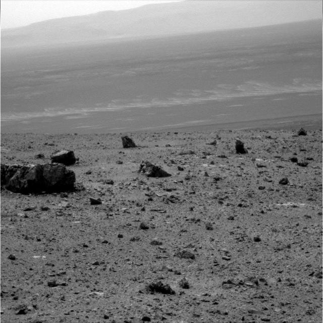
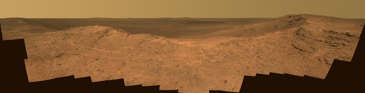
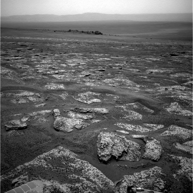
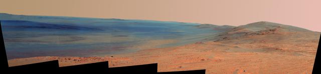
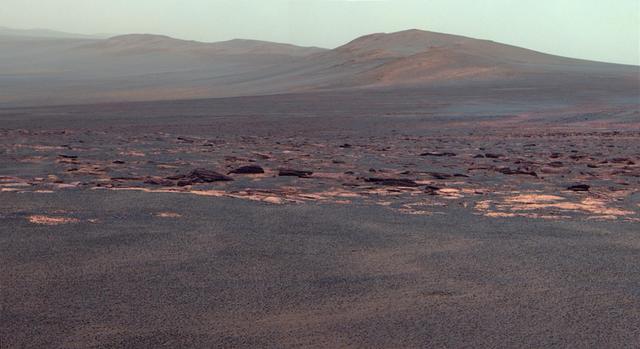
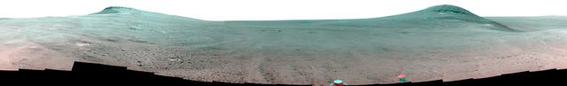
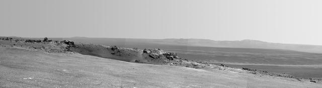
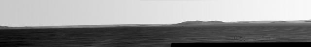
North Rim of Endeavour Crater on Horizon
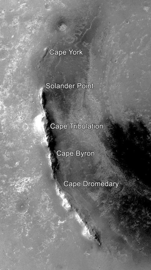
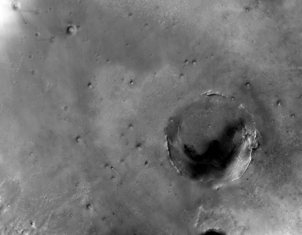
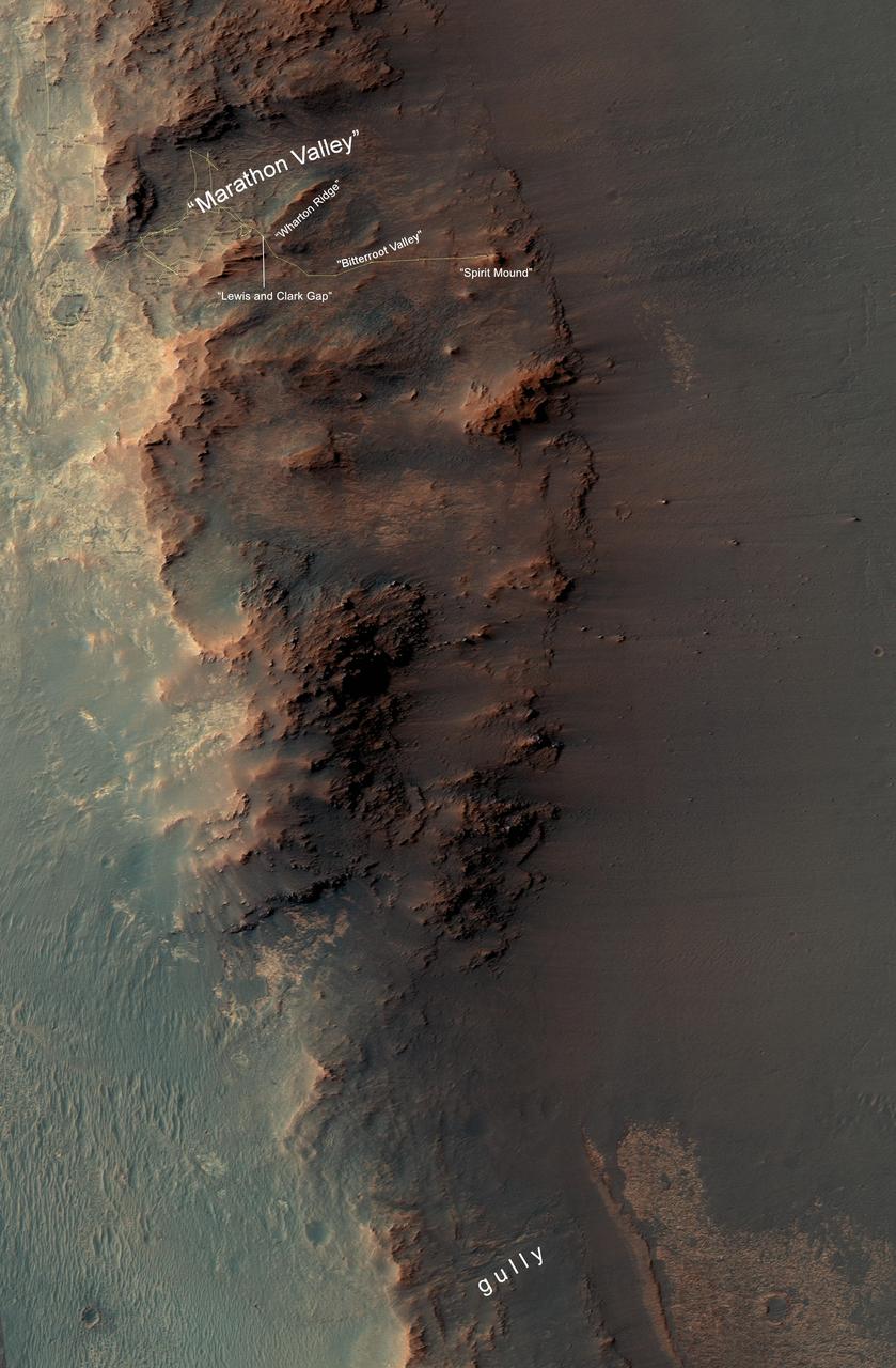
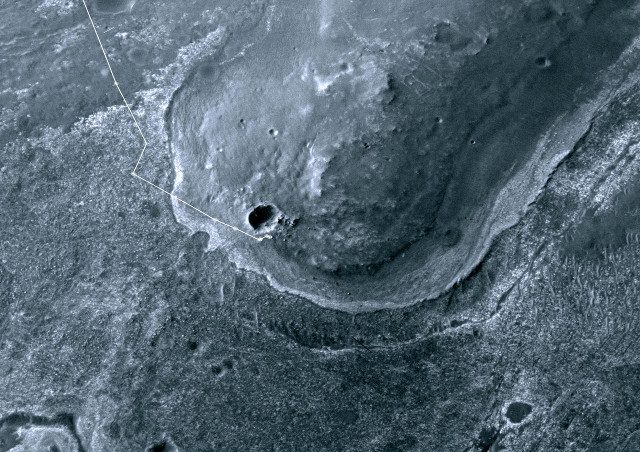
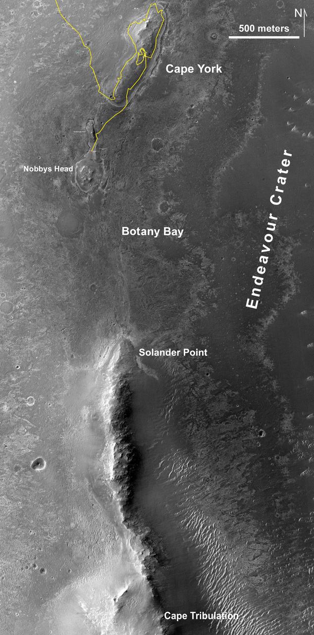
This orbital image of the western rim of Mars' Endeavour Crater covers an area about 5 miles (8 kilometers) east-west by about 9 miles (14 kilometers) north-south and indicates the names of some of the raised segments of the rim. NASA's Mars Exploration Rover Opportunity arrived at Endeavour in 2011 after exploring smaller craters to the northwest during its first six years on Mars. It initially explored the "Cape York" segment, then headed south. It reached the northern end of "Cape Tribulation" in late 2014 and the southern tip of that segment in April 2017. A key destination in the "Cape Byron" segment is "Perseverance Valley," where the rover team plans to investigate whether the valley was carved by water, wind or a debris flow initiated by water. This image is from the Context Camera on NASA's Mars Reconnaissance Orbiter. Malin Space Science Systems, San Diego, California, built and operates that camera. NASA's Jet Propulsion Laboratory, a division of Caltech in Pasadena, California, built and operates Opportunity. https://photojournal.jpl.nasa.gov/catalog/PIA21490
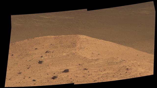
This scene from the panoramic camera (Pancam) on NASA's Mars Exploration Rover Opportunity shows "Spirit Mound" overlooking the floor of Endeavour Crater. The mound stands near the eastern end of "Bitterroot Valley" on the western rim of the crater, and this view faces eastward. For scale, the two rocks at lower center are each about 8 inches (about 20 centimeters) across. At the mound's crest line, the image covers an area about 28 feet (about 8.5 meters) wide. The component images for this mosaic were taken on Sept. 21, 2016, during the 4,501st Martian day, or sol, of Opportunity's work on Mars. Exposures were taken through three of the Pancam's color filters, centered on wavelengths of 753 nanometers (near-infrared), 535 nanometers (green) and 432 nanometers (violet). The scene is presented here in approximately true color. The informal name the rover's science team chose for this feature refers to Spirit Mound in South Dakota. The team is using names of sites visited by the Lewis and Clark Expedition as informal names for features in Mars' Bitterroot Valley (named for a valley that the expedition visited in Montana). http://photojournal.jpl.nasa.gov/catalog/PIA20851
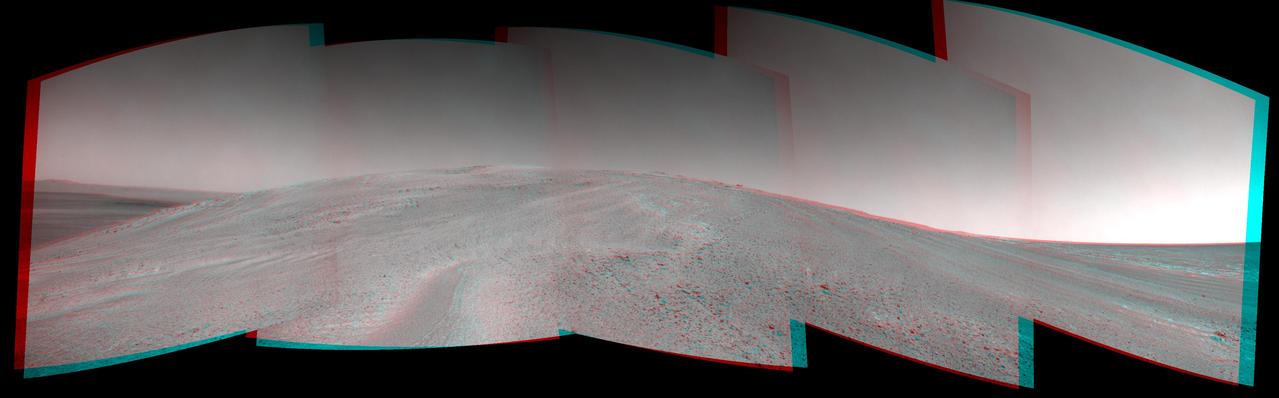
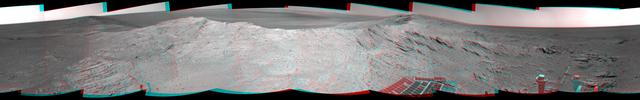
West Rim of Endeavour and a Farther Crater Rim on Horizon
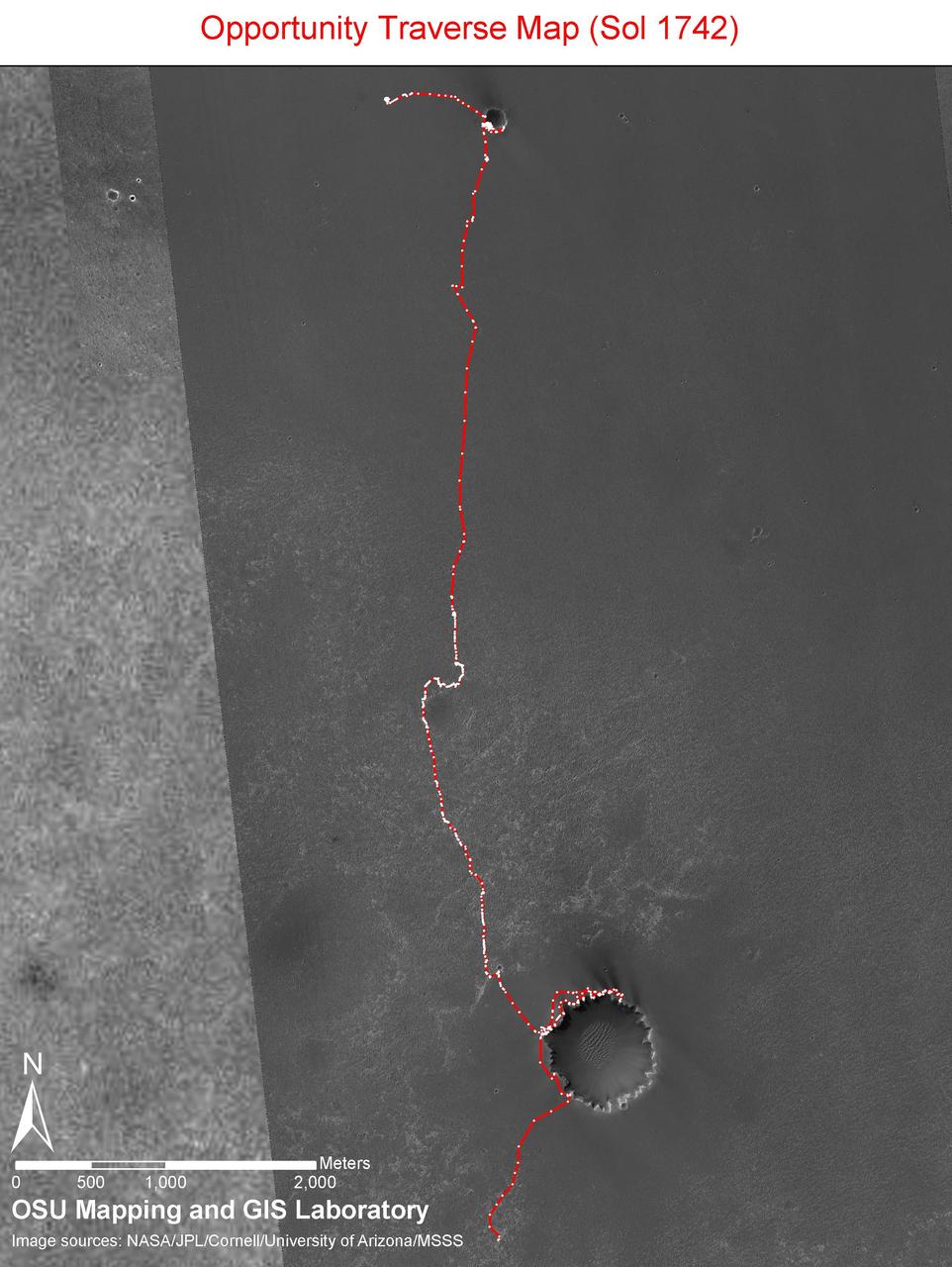
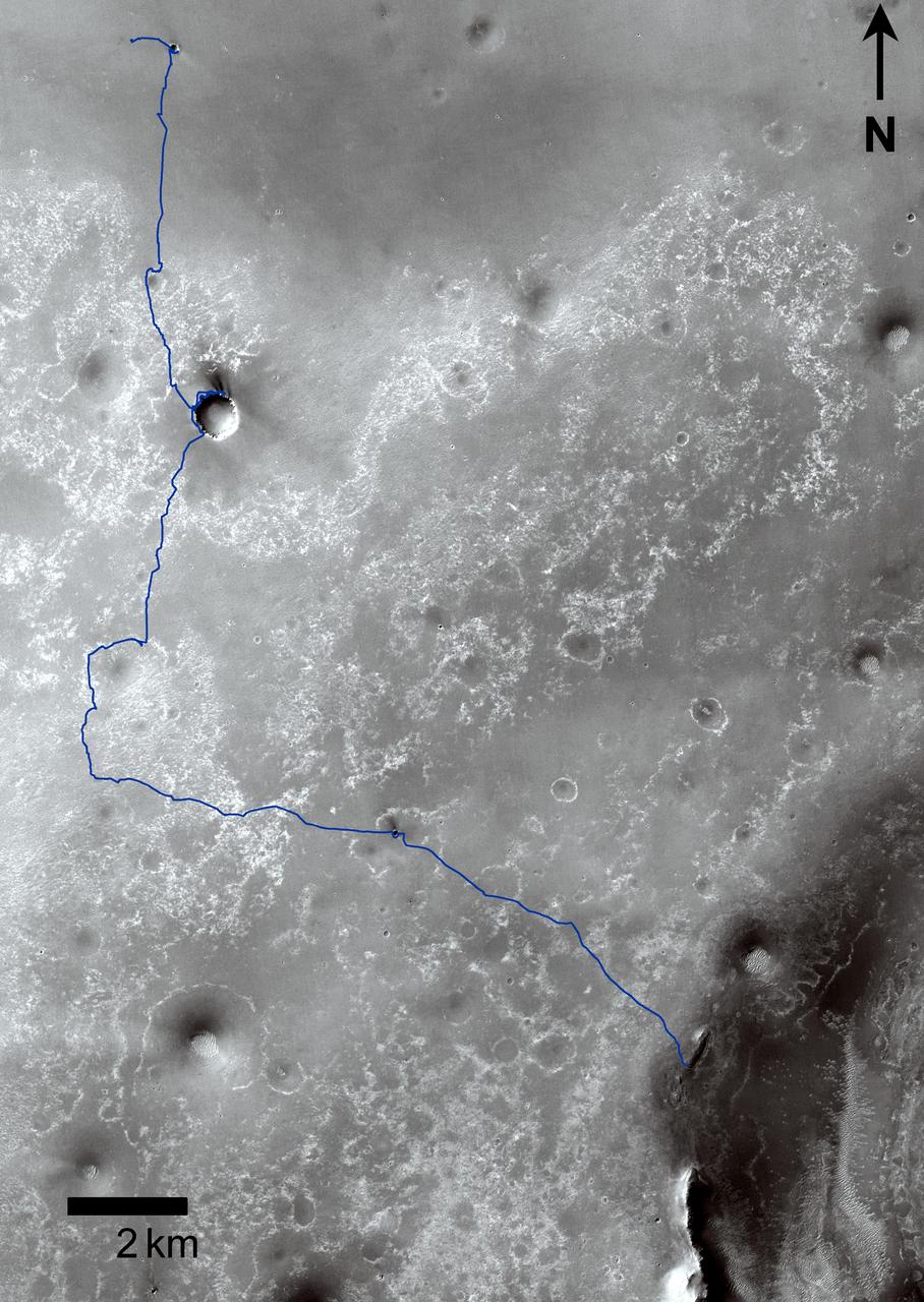
Opportunity Sol 1742 Traverse Map with Endeavour Crater
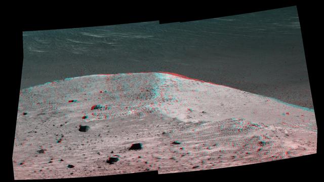
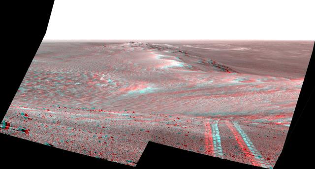
This stereo scene from NASA's Mars Exploration Rover Opportunity shows "Spirit Mound" overlooking the floor of Endeavour Crater. The mound stands near the eastern end of "Bitterroot Valley" on the western rim of the crater, and this view faces eastward. The image combines views from the left eye and right eye of the rover's panoramic camera (Pancam) to appear three-dimensional when seen through blue-red glasses with the red lens on the left. The component images were taken on Sept. 21, 2016, during the 4,501st Martian day, or sol, of Opportunity's work on Mars For scale, the two rocks at lower center are each about 8 inches (about 20 centimeters) across. At the mound's crest line, the image covers an area about 28 feet (about 8.5 meters) wide. The informal name the rover's science team chose for this feature refers to Spirit Mound in South Dakota. The team is using names of sites visited by the Lewis and Clark Expedition as informal names for features in Mars' Bitterroot Valley (named for a valley that the expedition visited in Montana). http://photojournal.jpl.nasa.gov/catalog/PIA20853
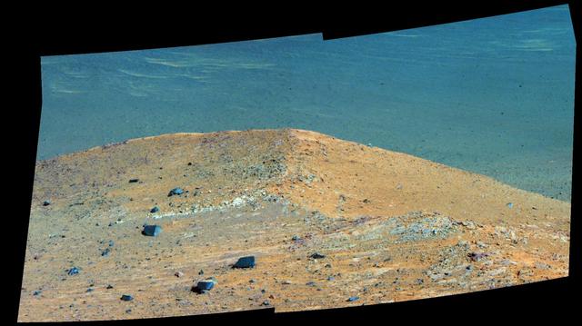
This scene from the panoramic camera (Pancam) on NASA's Mars Exploration Rover Opportunity shows "Spirit Mound" overlooking the floor of Endeavour Crater. The mound stands near the eastern end of "Bitterroot Valley" on the western rim of the crater, and this view faces eastward. In this version of the scene the landscape is presented in enhanced color to make differences in surface materials more easily visible For scale, the two rocks at lower center are each about 8 inches (about 20 centimeters) across. At the mound's crest line, the image covers an area about 28 feet (about 8.5 meters) wide. The component images for this mosaic were taken on Sept. 21, 2016, during the 4,501st Martian day, or sol, of Opportunity's work on Mars. Exposures were taken through three of the Pancam's color filters, centered on wavelengths of 753 nanometers (near-infrared), 535 nanometers (green) and 432 nanometers (violet). The informal name the rover's science team chose for this feature refers to Spirit Mound in South Dakota. The team is using names of sites visited by the Lewis and Clark Expedition as informal names for features in Mars' Bitterroot Valley (named for a valley that the expedition visited in Montana). http://photojournal.jpl.nasa.gov/catalog/PIA20852
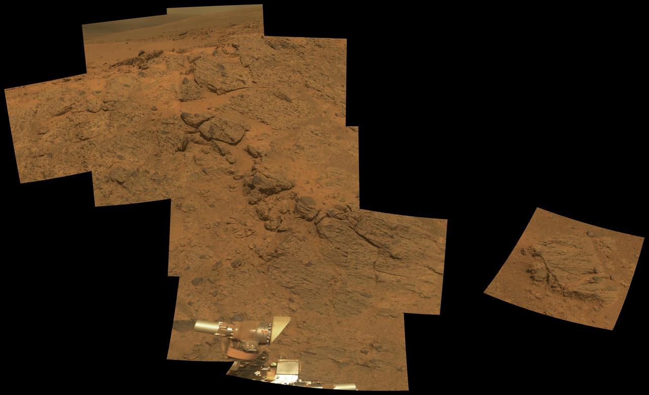
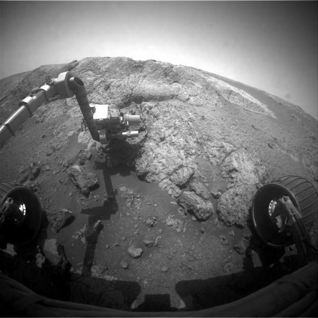
The large rock on the left in the foreground, informally named Tisdale 1. It is part of a group of rocks that appear to have been ejected by the excavation of Odyssey crater on the rim of Endeavour crater by NASA Mars rover Odyssey.
East Rim of Endeavour Crater in Opportunity View, Sol 2407 False Color
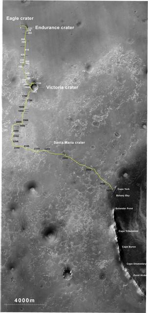
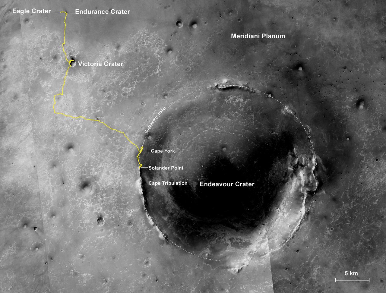
The yellow line on this map shows where NASA Mars Rover Opportunity has driven from the place where it landed in January 2004, inside Eagle crater, at the upper left end of the track, to a point approaching the rim of Endeavour crater.
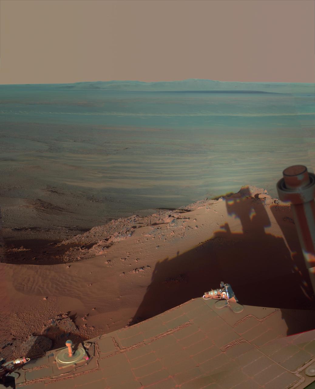
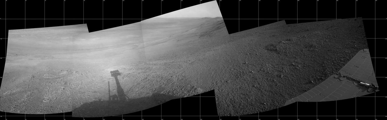
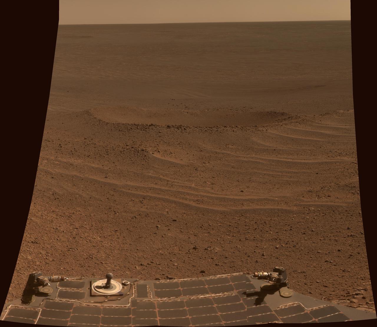
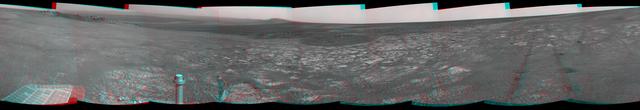
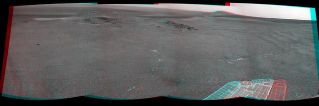
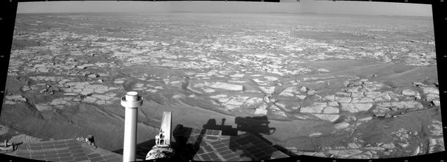
NASA Mars Exploration Rover Opportunity used its navigation camera to record this vista looking eastward across Endeavour Crater, with the rover own shadow in the foreground.
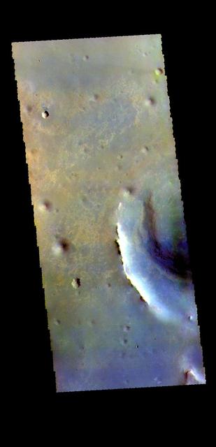
Today's false color image shows part of Endeavour Crater in Meridiani Planum. The MER Opportunity Rover drove along the rim of this crater, ending it's 15 year mission after losing contact during a global dust storm. The THEMIS VIS camera contains 5 filters. The data from different filters can be combined in multiple ways to create a false color image. These false color images may reveal subtle variations of the surface not easily identified in a single band image. Orbit Number: 63135 Latitude: -2.24737 Longitude: 354.624 Instrument: VIS Captured: 2016-03-08 07:47 https://photojournal.jpl.nasa.gov/catalog/PIA23219
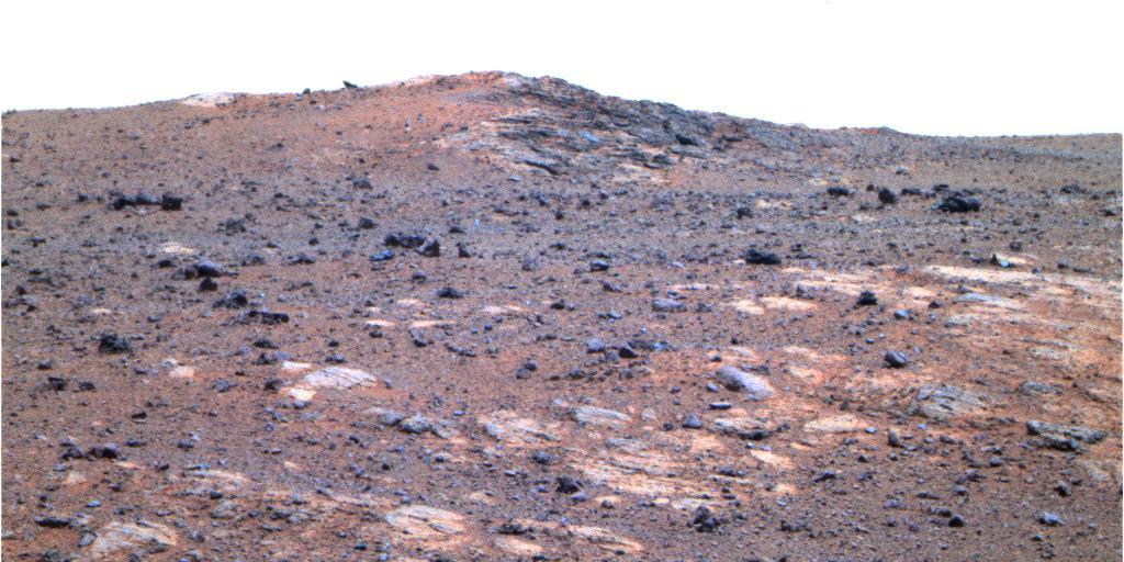
This image shows the portion of the rim of Endeavour crater given the informal name Spirit Point. This is the location where the team operating NASA Mars Exploration Rover Opportunity plans to drive the rover to its arrival at the Endeavour rim.
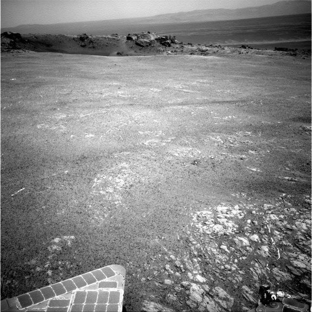
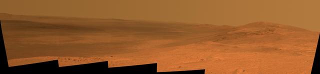
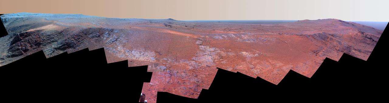
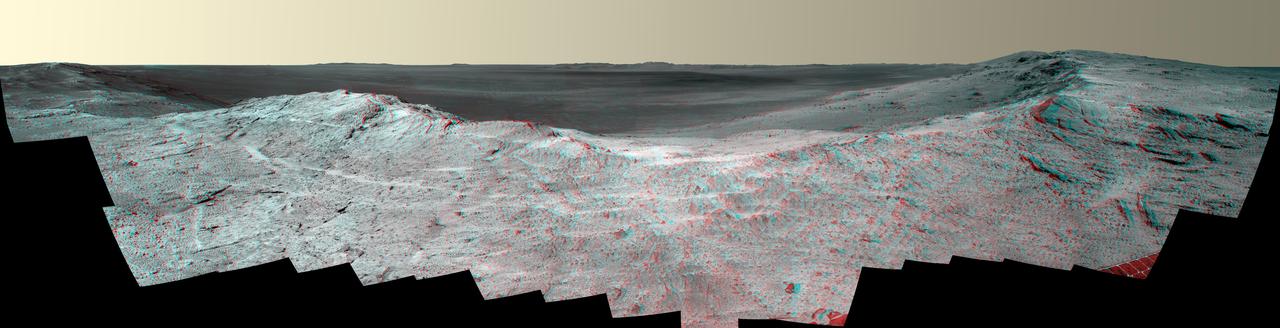
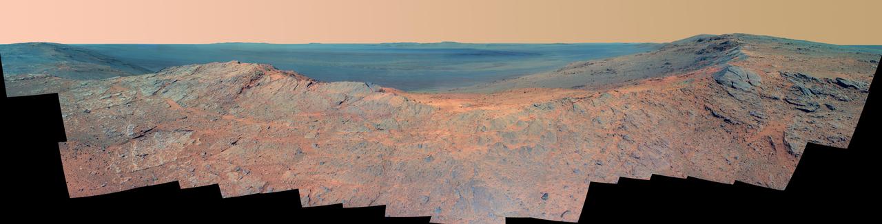
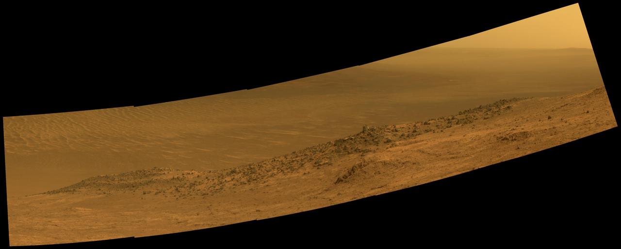
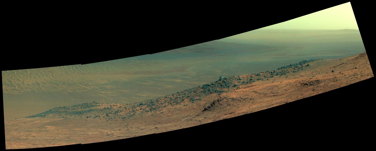
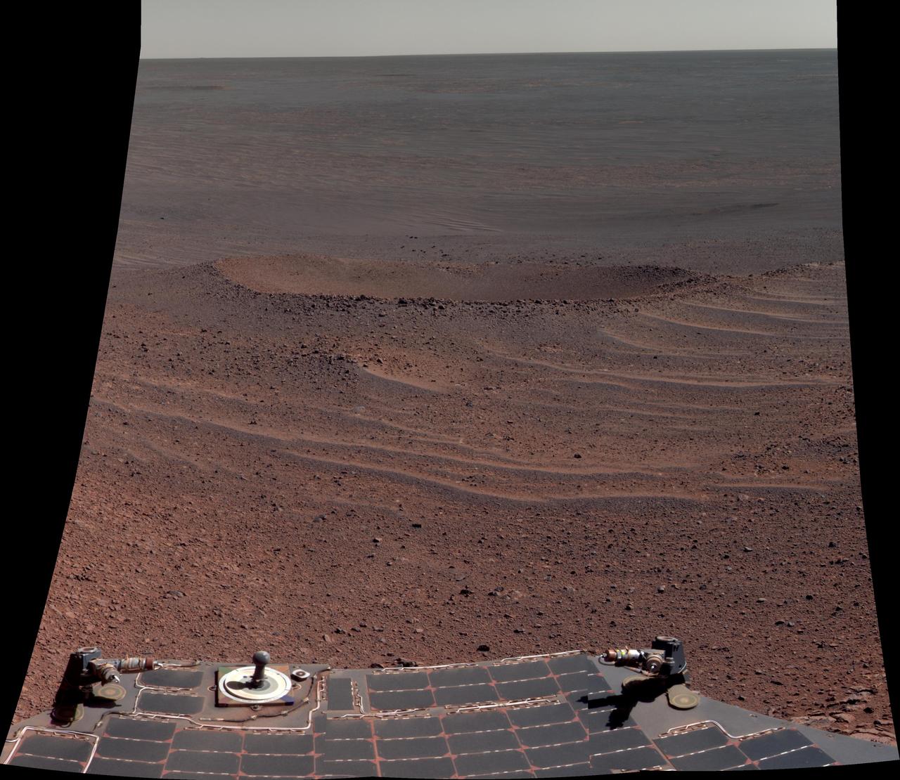
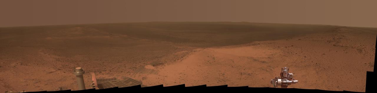
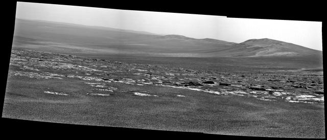
Toward the right side of this enhanced-color scene is a broad notch in the crest of the western rim of Endeavour Crater. Wheel tracks in that area were left by NASA's Mars Exploration Rover Opportunity as it observed "Perseverance Valley" from above in the spring of 2017. The valley is a major destination for the rover's extended mission. It descends out of sight on the inner slope of the rim, extending down and eastward from that notch. Opportunity's panoramic camera (Pancam) took the component images for this view from a position outside the crater during the span of June 7 to June 19, 2017, sols 4753 to 4765 of the rover's work on Mars. This scene includes features that might have been ancient channels from water, ice or wind moving toward the notch in the rim, which might have been a spillway. Perseverance Valley, just on the other side, was likely carved by action of some fluid, such as water, water-lubricated debris, or wind. The mission is investigating to learn more about that process from evidence in place. The panorama spans about three-fourths of a full-circle view, from southeastward on the left, through westward in the middle, to northeastward on the right. High points visible on the rim of Endeavour Crater include "Winnemucca" on the left and "Cape Tribulation" on the right. Winnemucca is part of the "Cape Byron" portion of the crater rim. The horizon at far right extends across the floor of Endeavour Crater, which is about 14 miles (22 kilometers) in diameter. Opportunity has been investigating sites on and near the western rim of Endeavour since 2011, following seven years of exploring smaller craters after its 2004 landing. This view merges exposures taken through three of the Pancam's color filters, centered on wavelengths of 753 nanometers (near-infrared), 535 nanometers (green) and 432 nanometers (violet). Color is enhanced in this version to make differences in surface materials more easily visible. The rover team calls this the "Sprained Ankle" panorama because the images were collected during a driving moratorium while engineers diagnosed a temporary steering stall with one front wheel pointed outward more than 30 degrees. The team was able to straighten the wheel to point straight ahead, and then resumed driving. The location from which this scene was recorded is labeled as "Sol 4752" on a later traverse map. Opportunity subsequently entered the upper end of Perseverance Valley and returned views looking down the valley and back up toward the rim crest from the location it reached on July 7 (Sol 4782). https://photojournal.jpl.nasa.gov/catalog/PIA21722
NASA Mars Exploration Rover Opportunity arrived at the rim of Endeavour crater on Aug. 9, 2011, after a trek of more than 13 miles 21 kilometers lasting nearly three years since departing the rover previous major destination, Victoria crater.
A ridge called "Rocheport" on the western rim of Mars' Endeavour Crater spans this stereo scene from the panoramic camera (Pancam) on NASA's Mars Exploration Rover Opportunity. The mosaic combines views from the left eye and right eye of the Pancam to appear three-dimensional when seen through blue-red glasses with the red lens on the left. The view extends from south-southeast on the left to north on the right. Rocheport is near the southern end of an Endeavour rim segment called "Cape Tribulation." The Pancam took the component images for this panorama on Feb. 25, 2017, during the 4,654th Martian day, or sol, of Opportunity's work on Mars. Opportunity began exploring the western rim of Endeavour Crater in 2011 and reached the north end of Cape Tribulation in 2014. This ridge bears some grooves on its side, such as between the two dark shoulders angling down near the left edge of the scene. For scale, those shoulders are about 10 to 16 feet (3 to 5 meters) long. The grooves might have been carved long ago by water or ice or wind. The Rocheport name comes from a riverbank town in Missouri along the route of Lewis and Clark's "Corps of Discovery" Expedition. https://photojournal.jpl.nasa.gov/catalog/PIA21491

A ridge called "Rocheport" on the western rim of Mars' Endeavour Crater spans this mosaic of images from the panoramic camera (Pancam) on NASA's Mars Exploration Rover Opportunity. The view extends from south-southeast on the left to north on the right. Rocheport is near the southern end of an Endeavour rim segment called "Cape Tribulation." The Pancam took the component images for this panorama on Feb. 25, 2017, during the 4,654th Martian day, or sol, of Opportunity's work on Mars. Opportunity began exploring the western rim of Endeavour Crater in 2011 and reached the north end of Cape Tribulation in 2014. This ridge bears some grooves on its side, such as between the two dark shoulders angling down near the left edge of the scene. For scale, those shoulders are about 10 to 16 feet (3 to 5 meters) long. The grooves might have been carved long ago by water or ice or wind. The view merges exposures taken through three of the Pancam's color filters, centered on wavelengths of 753 nanometers (near-infrared), 535 nanometers (green) and 432 nanometers (violet). It is presented in approximately true color. The Rocheport name comes from a riverbank town in Missouri along the route of Lewis and Clark's "Corps of Discovery" Expedition. https://photojournal.jpl.nasa.gov/catalog/PIA21493
This vista of the Endeavour Crater rim was acquired by NASA Mars Exploration Rover Opportunity panoramic camera on April 18, 2014, from the southern end of Murray Ridge on the western rim of the crater.
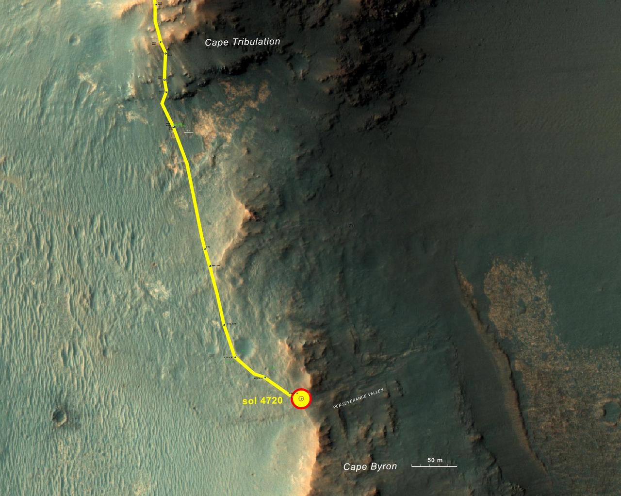
This graphic shows the route that NASA's Mars Exploration Rover Opportunity drove in its final approach to 'Perseverance Valley' on the western rim of Endeavour Crater. The map covers an area about four-tenths of a mile (two-thirds of a kilometer) wide, with the interior of the crater on the right. Opportunity entered this mapped area from the north along the gold traverse line on March 21, 2017, approaching the southern tip of the "Cape Tribulation" segment of Endeavour's rim. It reached the top of "Perseverance Valley" with a drive on Sol 4720 (the 4,720th Martian day) of the mission, on May 4, 2017. https://photojournal.jpl.nasa.gov/catalog/PIA21496
Toward the right side of this enhanced-color scene is a broad notch in the crest of the western rim of Endeavour Crater. Wheel tracks in that area were left by NASA's Mars Exploration Rover Opportunity as it observed "Perseverance Valley" from above in the spring of 2017. The valley is a major destination for the rover's extended mission. It descends out of sight on the inner slope of the rim, extending down and eastward from that notch. Opportunity's panoramic camera (Pancam) took the component images for this view from a position outside the crater during the span of June 7 to June 19, 2017, sols 4753 to 4765 of the rover's work on Mars. This scene includes features that might have been ancient channels from water, ice or wind moving toward the notch in the rim, which might have been a spillway. Perseverance Valley, just on the other side, was likely carved by action of some fluid, such as water, water-lubricated debris, or wind. The mission is investigating to learn more about that process from evidence in place. The panorama spans about three-fourths of a full-circle view, from southeastward on the left, through westward in the middle, to northeastward on the right. High points visible on the rim of Endeavour Crater include "Winnemucca" on the left and "Cape Tribulation" on the right. Winnemucca is part of the "Cape Byron" portion of the crater rim. The horizon at far right extends across the floor of Endeavour Crater, which is about 14 miles (22 kilometers) in diameter. Opportunity has been investigating sites on and near the western rim of Endeavour since 2011, following seven years of exploring smaller craters after its 2004 landing. This view merges exposures taken through three of the Pancam's color filters, centered on wavelengths of 753 nanometers (near-infrared), 535 nanometers (green) and 432 nanometers (violet). Color is enhanced in this version to make differences in surface materials more easily visible. The rover team calls this the "Sprained Ankle" panorama because the images were collected during a driving moratorium while engineers diagnosed a temporary steering stall with one front wheel pointed outward more than 30 degrees. The team was able to straighten the wheel to point straight ahead, and then resumed driving. The location from which this scene was recorded is labeled as "Sol 4752" on a later traverse map. Opportunity subsequently entered the upper end of Perseverance Valley and returned views looking down the valley and back up toward the rim crest from the location it reached on July 7 (Sol 4782). https://photojournal.jpl.nasa.gov/catalog/PIA21722
This scene from the panoramic camera Pancam on NASA Mars Exploration Rover Opportunity catches Pillinger Point, on the western rim of Endeavour Crater, in the foreground.
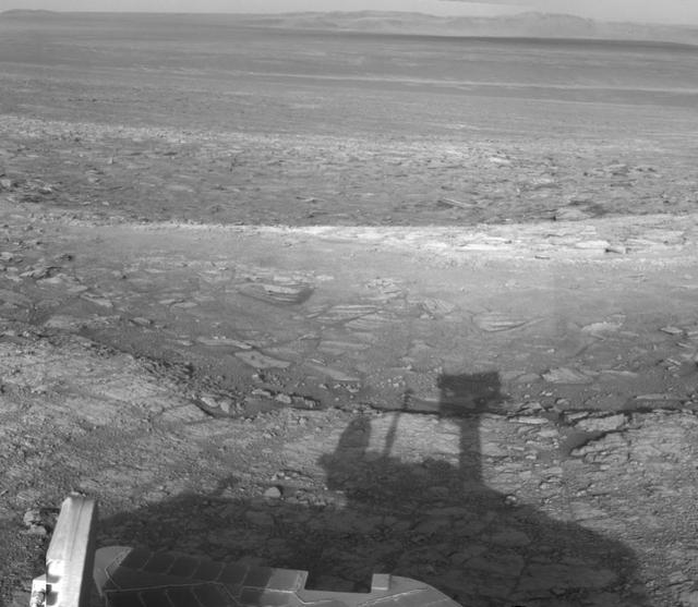
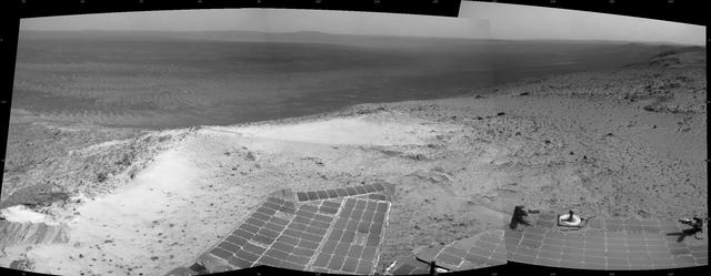
NASA Mars Rover Opportunity catches its own late-afternoon shadow in this dramatically lit view eastward across Endeavour Crater on Mars.
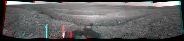
This 3-D view from the navigation camera on NASA Mars Exploration Rover Opportunity shows a vista across Endeavour Crater, with the rover own shadow in the foreground.
A portion of the west rim of Endeavour crater sweeps southward in this color view from NASA Mars Exploration Rover Opportunity. The rover first destination on the rim, called Spirit Point in tribute to Opportunity now-inactive twin, Spirit.
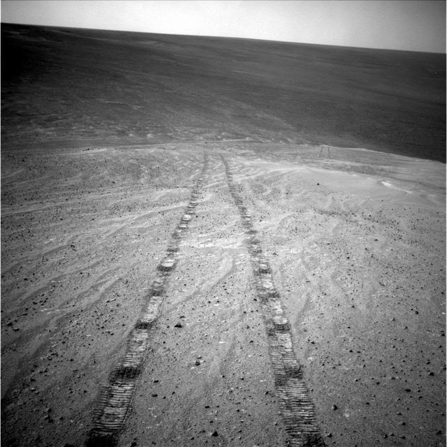
This image from the navigation camera on NASA Mars Exploration Rover Opportunity shows the view ahead on the day before the rover reached the rim of Endeavour crater. It was taken during the 2,680th Martian day, or sol, of the rover work on Mars.
A ridge called "Rocheport" on the western rim of Mars' Endeavour Crater spans this mosaic of images from the panoramic camera (Pancam) on NASA's Mars Exploration Rover Opportunity. In this version of the scene the landscape is presented in enhanced color to make differences in surface materials more easily visible. The view extends from south-southeast on the left to north on the right. Rocheport is near the southern end of an Endeavour rim segment called "Cape Tribulation." The Pancam took the component images for this panorama on Feb. 25, 2017, during the 4,654th Martian day, or sol, of Opportunity's work on Mars. Opportunity began exploring the western rim of Endeavour Crater in 2011 and reached the north end of Cape Tribulation in 2014. This ridge bears some grooves on its side, such as between the two dark shoulders angling down near the left edge of the scene. For scale, those shoulders are about 10 to 16 feet (3 to 5 meters) long. The grooves might have been carved long ago by water or ice or wind. The Rocheport name comes from a riverbank town in Missouri along the route of Lewis and Clark's "Corps of Discovery" Expedition. The view merges exposures taken through three of the Pancam's color filters, centered on wavelengths of 753 nanometers (near-infrared), 535 nanometers (green) and 432 nanometers (violet). https://photojournal.jpl.nasa.gov/catalog/PIA21492
This mosaic scene combining five images from the navigation camera (Navcam) on NASA's Mars Exploration Rover Opportunity shows a view from inside the upper end of "Perseverance Valley" on the inner slope of Endeavour Crater's western rim. The valley is the main destination for the current two-year extension of the 13-year-old Opportunity mission on Mars. It was likely carved long ago by a fluid, such as water, water-lubricated debris or wind. The rover team is using Opportunity to learn more about the processes that shaped the valley. Plans call for driving the rover down the full length of the valley, about twice the length of a football field. Opportunity entered the top end of Perseverance Valley after studying the area just outside the crater rim above the valley during the spring and early summer of 2017. The images combined into this scene were taken on July 7, 2017, during the 4,782nd Martian day, or sol, of the rover's work on Mars. Opportunity had driven about 45 feet (13.8 meters) earlier that same sol. The portion of this scene to the left of the shadow of the rover's mast shows Perseverance Valley descending to the floor of Endeavour Crater. Foreground areas in the middle and right sections of the scene shows terrain details in the upper end of the valley. More distant in the center section, the rim of Endeavour Crater extends southeastward. The full scene spans from northeast at left to southwest at right. https://photojournal.jpl.nasa.gov/catalog/PIA21724
This false-color vista of the Endeavour Crater rim was acquired by NASA Mars Exploration Rover Opportunity panoramic camera on April 18, 2014, from Murray Ridge on the western rim of the crater.
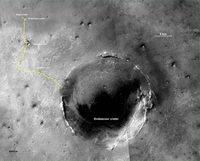
The yellow line on this map shows where NASA Mars Rover Opportunity has driven from the place where it landed in January 2004, inside Eagle crater, at the upper left end of the track, to a point approaching the rim of Endeavour crater.
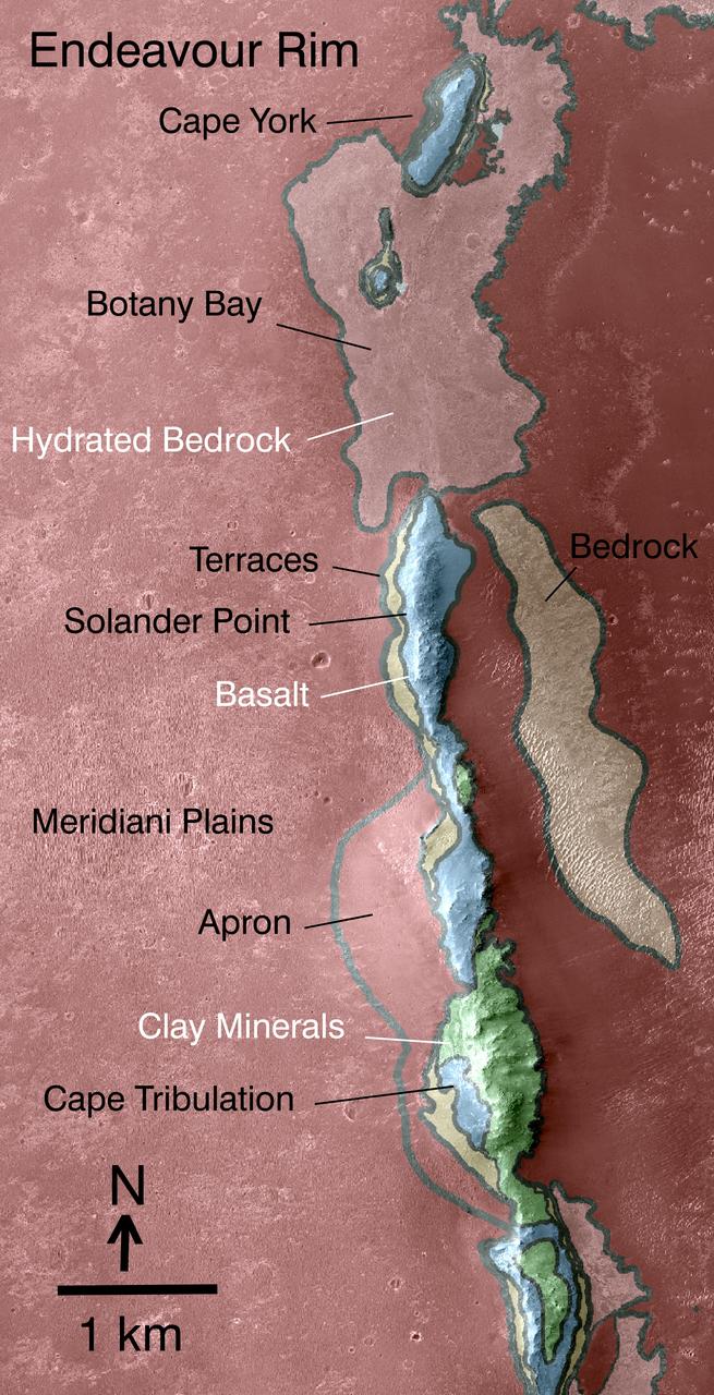
This map indicates some of the geological information gained from orbital observations of Endeavour Crater, which has been the long-term destination for NASA Mars Exploration Rover Opportunity since mid-2008.
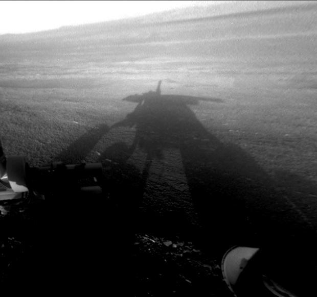
NASA Mars Exploration Rover Opportunity captured this view of its afternoon shadow stretching into Endeavour Crater during the 3,051st Martian day, or sol, of Opportunity work on Mars Aug. 23, 2012.
This stereo vista from the panoramic camera Pancam of NASA Mars Exploration Rover Opportunity catches Pillinger Point, on the western rim of Endeavour Crater, in the foreground. You need 3-D glasses to view this image.
This scene shows the Murray Ridge portion of the western rim of Endeavour Crater on Mars as seen by NASA rover Opportunity; this feature is called Murray Ridge in tribute to Bruce Murray 1931-2013, an influential advocate for planetary exploration.
NASA Mars Exploration Rover Opportunity used its navigation camera Navcam to record this image of the northern end of Solander Point, a raised section of the western rim of Endeavour Crater.
A portion of the west rim of Endeavour crater sweeps southward in this image from NASA Mars Exploration Rover Opportunity. The view is presented in false color to emphasize differences among materials in the rocks and the soils.
This false-color scene from the panoramic camera Pancam on NASA Mars Exploration Rover Opportunity catches Pillinger Point, on the western rim of Endeavour Crater, in the foreground.

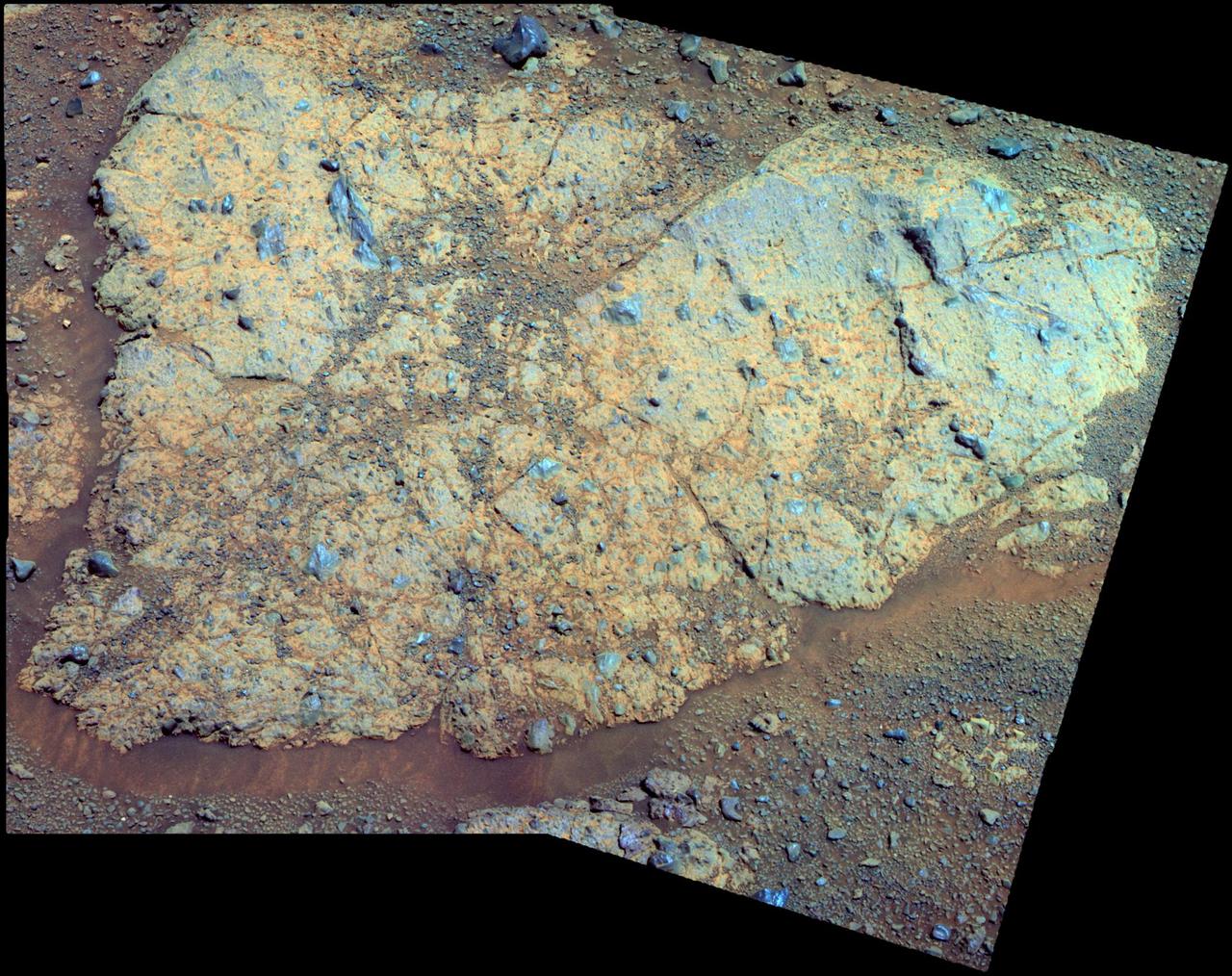
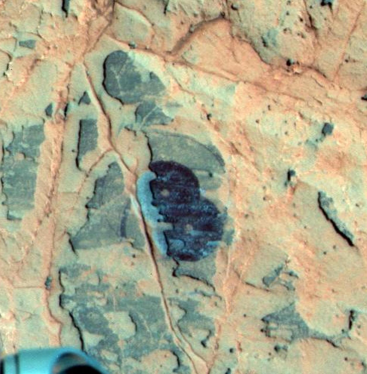
This relatively bright outcropping of rock, dubbed "Gasconade," was investigated by NASA's Mars Exploration Rover Opportunity while the rover was perched on "Spirit Mound" at the western edge of Mars' Endeavour Crater. This mosaic combines four frames taken by the microscopic imager on Opportunity's robotic arm on Oct. 2, 2016, during the 4,512st Martian day, or sol, of the rover's work on Mars. Enhanced color information from Opportunity's panoramic camera has been added to emphasize differences in the materials visible in the target. Figure A is a version with no color information added to the microscopic imager mosaic. The view covers an area about 2 inches (5 centimeters) wide. Opportunity's inspection found Gasconade to be a wind-etched outcrop with angular bits of darker rock within a lighter matrix, which may have been formed from fallout of the impact event that excavated the crater. This location of Spirit Mound, shown at PIA20854, is the deeper on the western rim of Endeavour Crater than any site visited previously by Opportunity. http://photojournal.jpl.nasa.gov/catalog/PIA21141
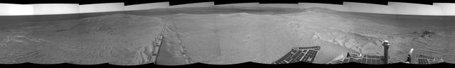
This full-circle, stereo panorama shows the terrain around the NASA Mars Exploration Rover Opportunity during the 3,105th Martian day, or sol, of the rover's work on Mars (Oct. 18, 2012). It was assembled from images taken by the rover's navigation camera. The view appears in three dimensions when viewed through red-blue glasses with the red lens on the left. South is at the center. North is on both ends. Opportunity had driven about 61 feet (18.5 meters) westward earlier on Sol 3105 to reach this location, which is on the northern portion of "Matijevic Hill" on the "Cape York" segment of the western rim of Endeavour Crater. The wheel tracks created by the drive are visible. For scale, the distance between the two parallel tracks is about 3.3 feet (1 meter). The basin of Endeavour Crater is in the left half of the image. Opportunity has been working on the western rim of Endeavour since mid-2011. The stereo panorama is presented as a cylindrical-perspective projection. http://photojournal.jpl.nasa.gov/catalog/PIA16559
An outcrop informally named Chester Lake is the second rock on the rim of Endeavour crater to be approached by NASA Mars Exploration Rover Opportunity for close inspection. Chester Lake is about 3 feet 1 meter across.
This scene shows the Murray Ridge portion of the western rim of Endeavour Crater on Mars, as seen by NASA Opportunity rover. It is presented in false color to make some differences between materials easier to see.
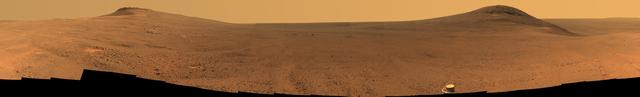
NASA Mars Exploration Rover Opportunity used its panoramic camera to record this eastward horizon view. A portion of Endeavour Crater eastern rim, in the distance, is visible over the Meridiani plain.
This stereo 3D scene from the Pancam on NASA Mars Exploration Rover Opportunity looks back toward part of the west rim of Endeavour Crater that the rover drove along, heading southward, during the summer of 2014.

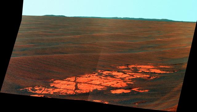
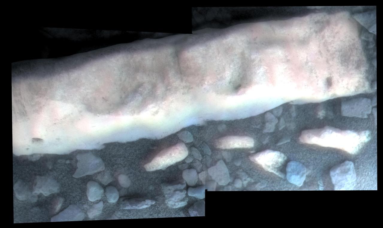
Bright veins cutting across outcrop in a section of Endeavour crater rim called Botany Bay are visible in the foreground and middle distance of this view from NASA Mars Exploration Rover Opportunity on sol 2,681 Aug. 9, 2011.
This scene from NASA's Mars Exploration Rover Opportunity shows "Wharton Ridge," which forms part of the southern wall of "Marathon Valley" on the western rim of Endeavour Crater. The full extent of Wharton Ridge is visible, with the floor of Endeavour Crater beyond it and the far wall of the crater in the distant background. Near the right edge of the scene is "Lewis and Clark Gap," through which Opportunity crossed from Marathon Valley to "Bitterroot Valley" in September 2016. Before the rover departed Marathon Valley, its panoramic camera (Pancam) acquired the component images for this scene on Aug. 30, 2016, during the 4,480th Martian day, or sol, of Opportunity's work on Mars. Opportunity's science team chose the ridge's name to honor the memory of Robert A. Wharton (1951-2012), an astrobiologist who was a pioneer in the use of terrestrial analog environments, particularly in Antarctica, to study scientific problems connected to the habitability of Mars. Over the course of his career, he was a visiting senior scientist at NASA Headquarters, vice president for research at the Desert Research Institute, provost at Idaho State University, and president of the South Dakota School of Mines and Technology. The view spans from east-northeast at left to southeast at right. It merges exposures taken through three of the Pancam's color filters, centered on wavelengths of 753 nanometers (near-infrared), 535 nanometers (green) and 432 nanometers (violet). It is presented in approximately true color. http://photojournal.jpl.nasa.gov/catalog/PIA20849
This scene from NASA's Mars Exploration Rover Opportunity shows "Wharton Ridge," which forms part of the southern wall of "Marathon Valley" on the western rim of Endeavour Crater. In this version of the scene the landscape is presented in enhanced color to make differences in surface materials more easily visible The full extent of Wharton Ridge is visible, with the floor of Endeavour Crater beyond it and the far wall of the crater in the distant background. Near the right edge of the scene is "Lewis and Clark Gap," through which Opportunity crossed from Marathon Valley to "Bitterroot Valley" in September 2016. Before the rover departed Marathon Valley, its panoramic camera (Pancam) acquired the component images for this scene on Aug. 30, 2016, during the 4,480th Martian day, or sol, of Opportunity's work on Mars. Opportunity's science team chose the ridge's name to honor the memory of Robert A. Wharton (1951-2012), an astrobiologist who was a pioneer in the use of terrestrial analog environments, particularly in Antarctica, to study scientific problems connected to the habitability of Mars. Over the course of his career, he was a visiting senior scientist at NASA Headquarters, vice president for research at the Desert Research Institute, provost at Idaho State University, and president of the South Dakota School of Mines and Technology. The view spans from east-northeast at left to southeast at right. Color in the scene comes from component images taken through three of the Pancam's color filters, centered on wavelengths of 753 nanometers (near-infrared), 535 nanometers (green) and 432 nanometers (violet). http://photojournal.jpl.nasa.gov/catalog/PIA20850
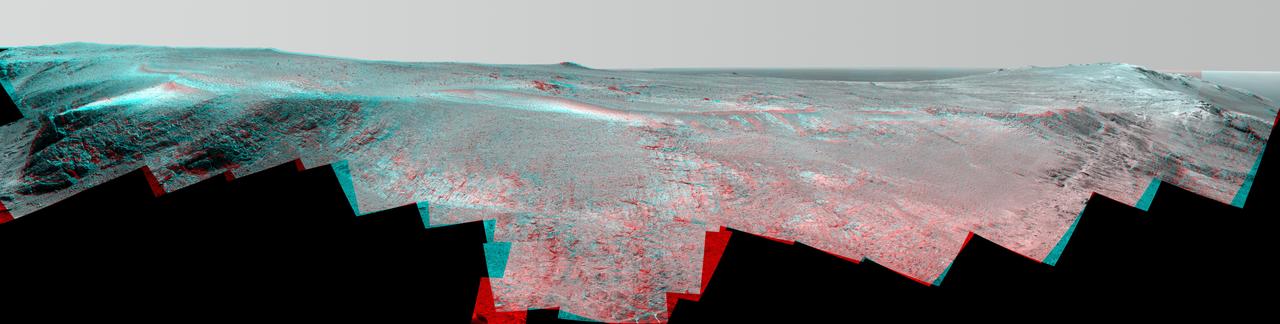
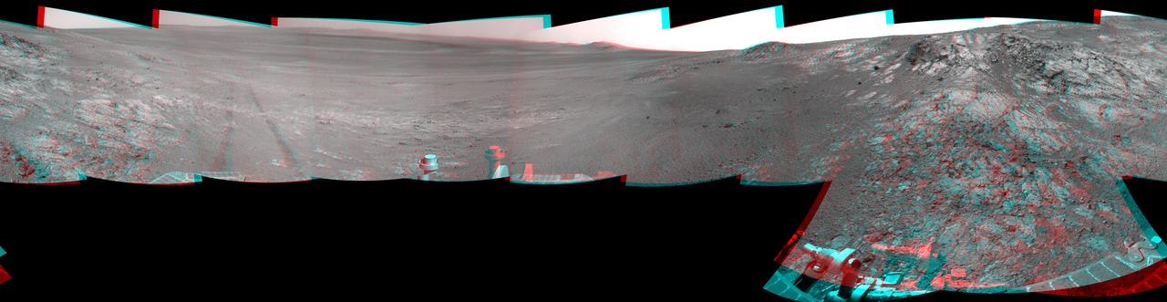
This June 2017 stereo scene from NASA's Mars Exploration Rover Opportunity rover shows the area just above "Perseverance Valley" on the rim of Endeavour Crater. The view combines images from the left eye and right eye of the rover's panoramic camera (Pancam) to appear three-dimensional when seen through blue-red glasses with the red lens on the left. Toward the right side of the scene is a broad notch in the crest of the crater's rim. Opportunity left wheel tracks in that area as it observed Perseverance Valley from above in the spring of 2017. The valley is a major destination for the rover's extended mission. It descends out of sight on the inner slope of the rim, extending down and eastward from that notch. Opportunity's Pancam took the component images for this view from a position outside the crater during the span of June 7 to June 19, 2017, sols 4753 to 4765 of the rover's work on Mars. This scene includes features that might have been ancient channels from water, ice or wind moving toward the notch in the rim, which might have been a spillway. Perseverance Valley, just on the other side, was likely carved by action of some fluid, such as water, water-lubricated debris, or wind. The mission is investigating to learn more about that process from evidence in place. The panorama spans about three-fourths of a full-circle view, from southeastward on the left, through westward in the middle, to northeastward on the right. High points visible on the rim of Endeavour Crater include "Winnemucca" on the left and "Cape Tribulation" on the right. Winnemucca is part of the "Cape Byron" portion of the crater rim. The horizon at far right extends across the floor of Endeavour Crater, which is about 14 miles (22 kilometers) in diameter. Opportunity has been investigating sites on and near the western rim of Endeavour since 2011, following seven years of exploring smaller craters after its 2004 landing The rover team calls this the "Sprained Ankle" panorama because the images were collected during a driving moratorium while engineers diagnosed a temporary steering stall with one front wheel pointed outward more than 30 degrees. The team was able to straighten the wheel to point straight ahead, and then resumed driving. The location from which this scene was recorded is labeled as "Sol 4752" on a later traverse map. Opportunity subsequently entered the upper end of Perseverance Valley and returned views looking down the valley and back up toward the rim crest from the location it reached on July 7 (Sol 4782). You need 3D glasses to view this image. https://photojournal.jpl.nasa.gov/catalog/PIA21721
This map show a portion of Endeavour Crater's western rim that includes the "Marathon Valley" area investigated intensively by NASA's Mars Exploration Rover Opportunity in 2015 and 2016, and a fluid-carved gully that is a destination to the south for the mission. The width of the area covered in the map is about half a mile (about 800 meters). North is up. Opportunity entered the northern end of the mapped area in January 2015 and entered Marathon Valley in July 2015. A gold line on the map, which may not be visible without zooming into the image, shows the rover's route. Curiosity departed Marathon Valley in September 2016 by driving southward through "Lewis and Clark Gap" into "Bitterroot Valley." The gully near the south end of the map was incised into Endeavour's rim long ago by a fluid, possibly a water-lubricated debris flow or a flow with mostly water. Driving into this gully to learn more about that flow is one of the goals for a two-year mission extension taking Opportunity through September 2018. A map showing wider context of Opportunity's route from its January 2004 landing in Eagle Crater to Endeavour Crater and Marathon Valley is at PIA19154. The rover's traverse shown here has been mapped by Tim Parker of NASA's Jet Propulsion Laboratory, Pasadena, California, onto an image from the High Resolution Imaging Science Experiment (HiRISE) camera on NASA's Mars Reconnaissance Orbiter. http://photojournal.jpl.nasa.gov/catalog/PIA20854
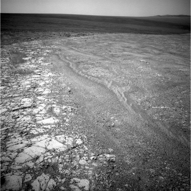
This image from the navigation camera (Navcam) on the mast of NASA's Mars Exploration Rover Opportunity provides a look back to the crest of Endeavour Crater's rim after the rover began descending "Perseverance Valley" on the rim's inner slope. The Navcam took this image on July 18, 2017, during the 4,793rd Martian day, or sol, of Opportunity's work on Mars. Wheel tracks from the top of the rim to the rover are visible above the rear solar panel of the vehicle. For scale, the distance between tracks from right-side wheels and tracks from left-side wheels is about 3.3 feet (1 meter). The knob-topped cylinder mounted at the edge of the solar panel is the calibration target for Opportunity's panoramic camera (Pancam). Opportunity's location on Sol 4793 was a site within the upper end of Perseverance Valley that the rover reached with a drive of about 45 feet (13.8 meters) on July 7 (Sol 4782). The rover team chose this location for Opportunity to spend about three weeks during a driving moratorium for the Mars solar conjunction period. Mars solar conjunction occurs once about every 26 months when Mars passes nearly behind the sun, from Earth's perspective. The relative positions of the three bodies makes radio transmission of commands from Earth to Mars unreliable. One advantage of this chosen location for Opportunity is a slight northward tilt for the solar panels, which adds to their power output during these weeks of southern-hemisphere autumn when daily sunshine is diminishing. https://photojournal.jpl.nasa.gov/catalog/PIA21725

This stereo view from NASA Opportunity rover shows Lunokhod 2 Crater, which lies south of Solander Point on the west rim of Endeavour Crater. Lunokhod 2 Crater is approximately 20 feet 6 meters in diameter.
This scene from NASA Opportunity rover shows Lunokhod 2 Crater, which lies south of Solander Point on the west rim of Endeavour Crater. Lunokhod 2 Crater is approximately 20 feet 6 meters in diameter.
This scene from NASA Opportunity rover shows Lunokhod 2 Crater, which lies south of Solander Point on the west rim of Endeavour Crater. Lunokhod 2 Crater is approximately 20 feet 6 meters in diameter.

The gold line on this image shows NASA Mars Exploration Rover Opportunity route as it investigating on the western rim of Endeavour Crater.
This panorama is the view NASA Mars Exploration Rover Opportunity gained from the top of the Cape Tribulation segment of the rim of Endeavour Crater.
This image from NASA rover Opportunity shows mostly a portion of Endeavour western rim left; a paler-looking terrain on the horizon beyond Endeavour right is part of a thick deposit of material ejected by the impact that excavated Iazu Crater.
During a long drive on Labor Day, NASA Mars Exploration Rover Opportunity reached the estimated halfway point of its journey from Victoria Crater to Endeavour Crater.
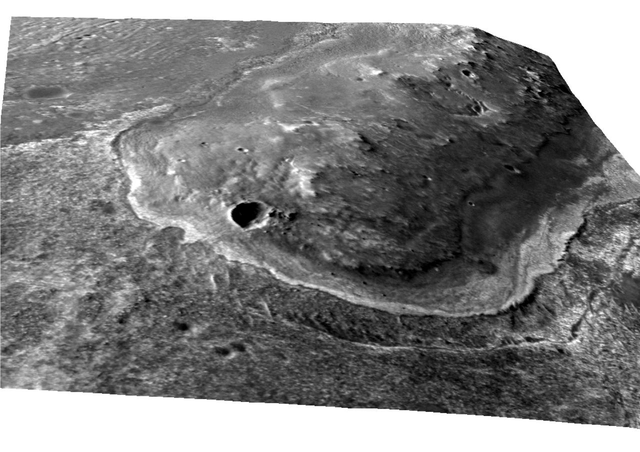
This crater, seen NASA Mars Reconnaissance Orbiter, is located in Meridiani Planum, about 20-kilometers northwest of where NASA Opportunity rover landed in 2004 and about 42-kilometers northwest of Endeavour Crater rim.
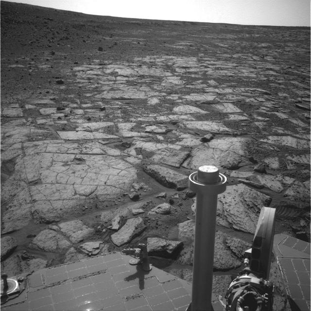
NASA Mars Exploration Rover Opportunity observed this outcrop on the Murray Ridge portion of the rim of Endeavour Crater as the rover approached the 10th anniversary of its landing on Mars.
This map of a portion of the western rim of Endeavour Crater on Mars shows the area where NASA Mars Exploration Rover Opportunity worked for 20 months.

This mosaic of images of the region around NASA Mars Exploration Rover Opportunity shows the relative locations of several craters, including Endeavour, in the Meridiani Planum region of Mars.
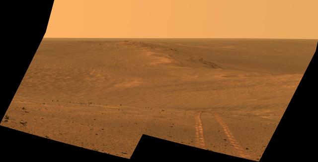
NASA Mars Exploration Rover Opportunity recorded this view of the summit of Cape Tribulation, on the western rim of Endeavour Crater on the day before the rover drove to the top.
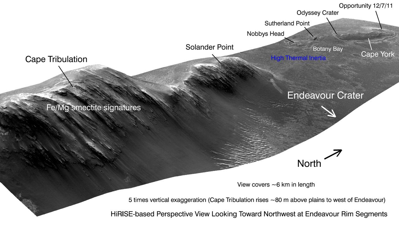
This view from NASA Mars Reconnaissance Orbiter shows portions of the western rim of Endeavour Crater on Mars from a perspective looking toward the northwest.
NASA Mars Exploration Rover Opportunity recorded this view of the summit of Cape Tribulation, on the western rim of Endeavour Crater on the day before the rover drove to the top.
This scene captured by NASA Mars Exploration Rover Opportunity shows the Spirit Point area of the rim, including a small crater, Odyssey on the rim, and the interior of Endeavour beyond.
NASA Mars Exploration Rover Opportunity captured this 3-D view after beginning to ascend the northwestern slope of Solander Point on the western rim of Endeavour Crater.
This image taken from orbit shows the path driven by NASA Mars Exploration Rover Opportunity in the weeks around the rover arrival at the rim of Endeavour crater.
NASA Mars Exploration Rover Opportunity captured this southward uphill view after beginning to ascend the northwestern slope of Solander Point on the western rim of Endeavour Crater.
NASA Mars Exploration Rover Opportunity captured this image as the rover ascended Murray Ridge above Solander Point on the western rim of Endeavour Crater.

The yellow line on this map shows where NASA Mars Rover Opportunity has driven from the place where it landed in January 2004, inside Eagle crater, upper left end of track, to a point about 2.2 miles away from reaching the rim of Endeavour crater.
This map shows the route driven by NASA Opportunity rover from the site of its landing, inside Eagle crater, to its location more than 112 months later, in late May 2013, departing the Cape York section of the rim of Endeavour crater.
This map shows route driven by NASA Mars Exploration Rover Opportunity from the site of its landing, inside Eagle crater at the upper left, to its location more than 91 months later, on the Cape York section of the rim of Endeavour crater.
This 3D scene shows the view from where NASA Mars Exploration Rover Opportunity first arrived on the rim of Endeavour crater, an impact crater about 14 miles 22 kilometers in diameter. You will need 3D glasses to view this image.

NASA Mars Exploration Rover Opportunity obtained this view from the top of the Cape Tribulation segment of the rim of Endeavour Crater. The rover reached this point three weeks before the 11th anniversary of its January 2004 landing on Mars.

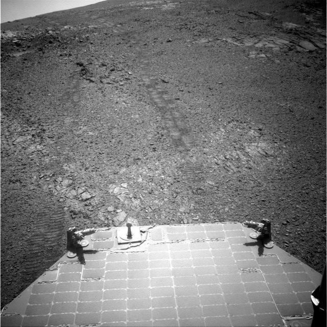
A shadow and wheel tracks of NASA Mars Exploration Rover Opportunity appear in this image taken by a rear hazard avoidance camera hazcam just after a drive on a slope above Endeavour Crater on March 22, 2016.
NASA Mars Exploration Rover Opportunity recorded this 3D view of a rise called Nobbys Head during a stop on a multi-week southward drive between two raised segments of the west rim of Endeavour Crater.
This scene from the Pancam on NASA Mars Exploration Rover Opportunity looks back toward part of the west rim of Endeavour Crater that the rover drove along, heading southward, during the summer of 2014.
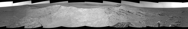
NASA Mars Exploration Rover capturde this 360-degree view near the ridgeline of Endeavour Crater western rim. The center is southeastward. Rocks on the slope to the right of center are in an outcrop area targeted for the rover to study.
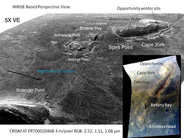
This graphic combines a perspective view from NASA Mars Reconnaissance Orbiter of the Botany Bay and Cape York areas of the rim of Endeavour Crater on Mars, and an inset with mapping-spectrometer data.
NASA Mars Exploration Rover Opportunity used its panoramic camera Pancam to capture this false-color view of the rim of Endeavour crater, the rover destination in a multi-year traverse along the sandy Martian landscape.
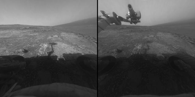
This image from NASA Mars Exploration Rover Opportunity shows the rover arm extended for examination of a target called Onaping at the base of an outcrop called Copper Cliff in the Matijevic Hill area of the west rim of Endeavour Crater.
Researchers used NASA Mars Exploration Rover Opportunity to find a water-related mineral on the ground that had been detected from orbit, and found it in the dark veneer of rocks on the rim of Endeavour Crater.
NASA Mars Exploration Rover Opportunity captured this view of a portion of Endeavour crater rim after a drive on Aug. 4, 2011 to reach Spirit Point, the chosen arrival site.
NASA Mars Exploration Rover Opportunity recorded this view of the western edge of Cape York, a segment of the rim of Endeavour Crater. A bright vein, informally named Homestake, is visible on the right side of the image.
NASA Mars Exploration Rover Opportunity inspected this mineral vein, called Homestake, in November 2011 at the northern end of the Cape York section of Endeavour Crater western rim.
Rising highest above the horizon in the right half of the image, captured by NASA Mars Exporation Rover, is a portion of the western rim of Endeavour Crater including a ridge informally named Cape Tribulation.
The component images for this 360-degree panorama were taken by NASA Mars Exploration Rover Opportunity after the rover drove about 97 feet southeastward on April 22, 2014. The location is on the western rim of Endeavour Crater.
The gold line on this image shows NASA Opportunity route from the landing site, in upper left, to the area it is investigating on the western rim of Endeavour Crater as of the rover 10th anniversary on Mars, in Earth years.
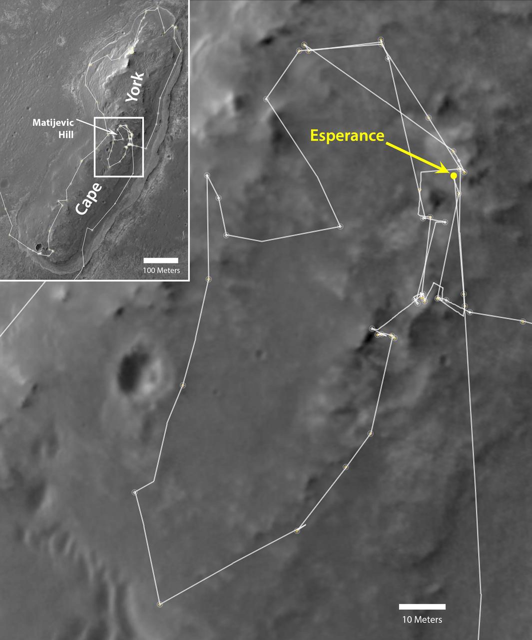
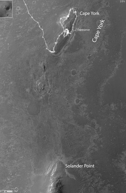
NASA Mars Exploration Rover Opportunity drove onto the Cape York segment of the rim of Endeavour Crater in August 2011 and departed Cape York in May 2013. The location of a rock target called Esperance is indicated in the main map.
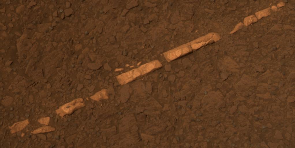
This color view from NASA Mars Exploration Rover Opportunity of a mineral vein called Homestake and is found to be rich in calcium and sulfur. Homestake is near the edge of the Cape York segment of the western rim of Endeavour Crater.
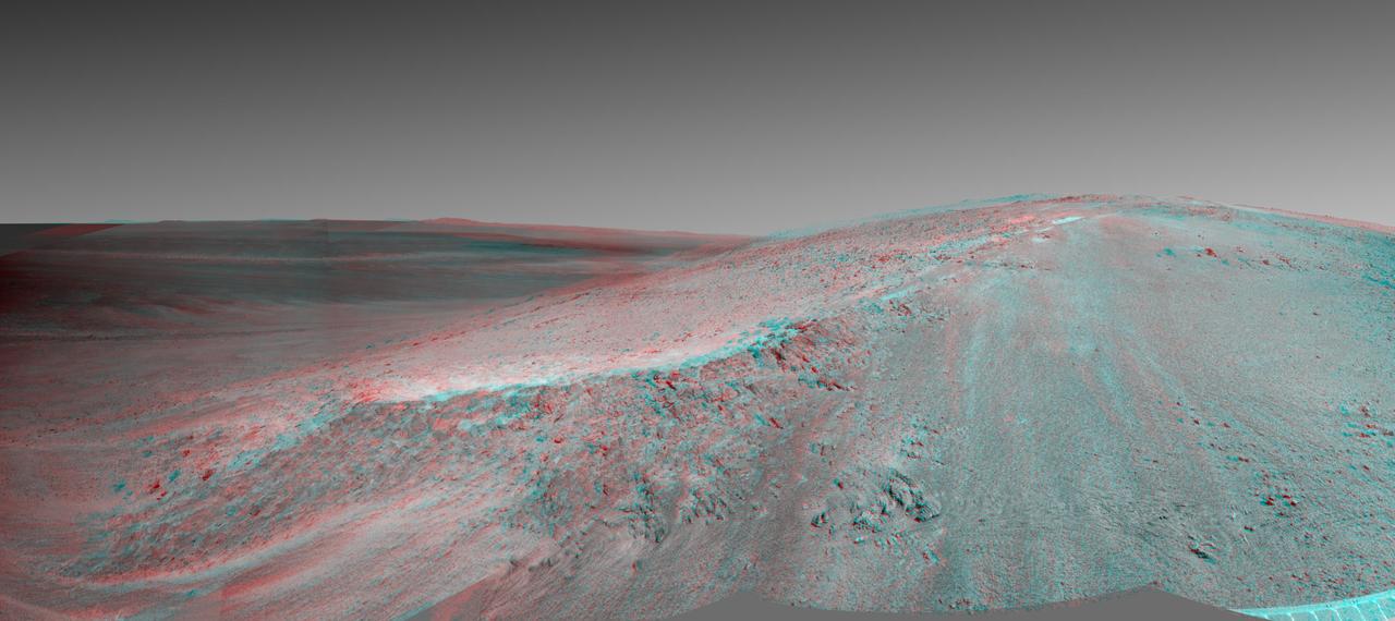
This stereo view shows the Murray Ridge portion of the western rim of Endeavour Crater on Mars. You need 3D glasses to view this image from NASA Mars Exploration Rover Opportunity.
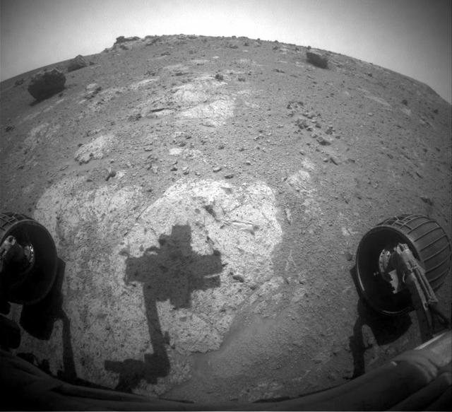
The robotic arm of NASA Mars Exploration Rover Opportunity casts a shadow on a rock outcrop called Chester Lake. The rock is on a low ridge called Cape York, which is a segment of the western rim of Endeavour crater.
These two images, taken five Martian days sols apart by the front hazard-avoidance camera on NASA Mars Exploration Rover Opportunity, document the Martian sky above the rover Endeavour Crater location becoming dustier.
This full-circle, 3-D panorama shows the terrain around the NASA Mars Exploration Rover Opportunity on part of a relatively flat, light-toned outcrop called Whitewater Lake. The basin of Endeavour Crater is in the left half of the image.
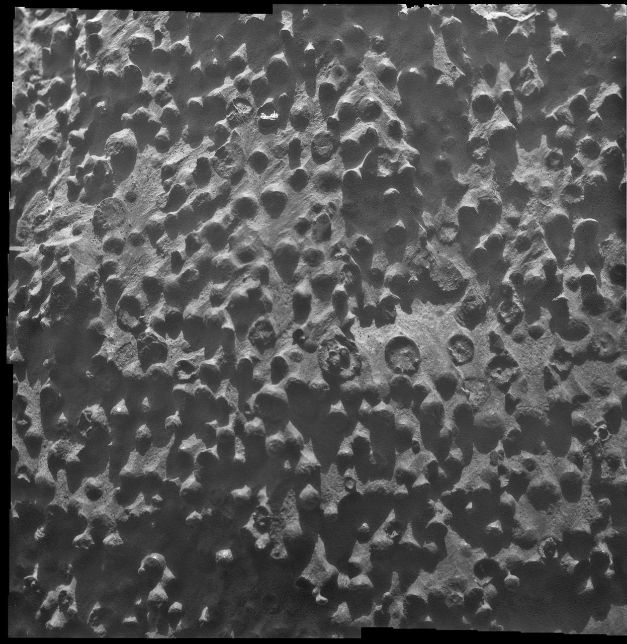
Small spherical objects fill the field in this mosaic combining four images from the Microscopic Imager on NASA Mars Exploration Rover Opportunity at an outcrop called Kirkwood in the Cape York segment of the western rim of Endeavour Crater.
This map of a portion of the western rim of Endeavour Crater on Mars shows the path of NASA Mars Exploration Rover Opportunity as the rover is driving from the Cape York segment of the rim to its next destination, the Solander Point segment.
NASA Mars Exploration Rover captured this stereo, 360-degree view near the ridgeline of Endeavour Crater western rim. The center is southeastward. You need 3D glasses to view this image.
This 3D 360-degree panorama assembled from images taken by the navigation camera on NASA Mars Exporation Rover Opportunity. The Sol 3000 site is near the northern tip of the Cape York segment of the western rim of Endeavour Crater.
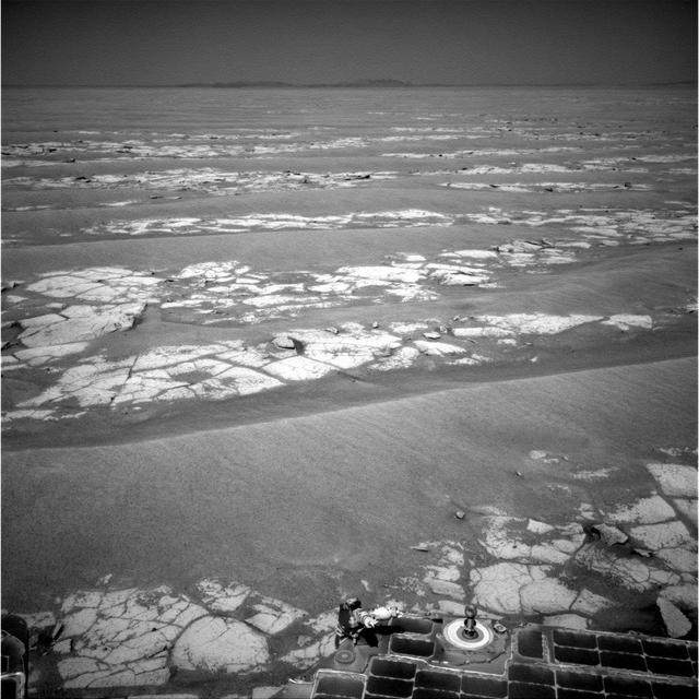
This mosaic of images from NASA Mars Exploration Rover Opportunity shows terrain that includes light-toned bedrock and darker ripples of wind-blown sand. Portions of Endeavour Crater rim are visible in the horizon of this scene.
The feature informally named Shoemaker Ridge in the Cape York segment of the western rim of Endeavour Crater includes outcrops that are likely impact breccias as seen by NASA rover Opportunity.