
The U.S. National Weather Service called it a “a crippling and historic winter blizzard.” In late January 2015, transportation systems from Trenton to Portland were shut down, and more than 35 million people hunkered down for extreme snowfall and biting winds. For those in New England, it turned out to be a monstrous storm. For the Mid-Atlantic region, not so much. Vast swaths of Massachusetts, Connecticut, Rhode Island, New Hampshire, Maine, and Long Island (NY) were blanketed with 15 to 25 inches (40 to 60 centimeters) of snow as of midday on January 27, 2015, and snow was expected to continue into January 28. Sustained winds reached gale force, with hurricane-force gusts along the coastlines. Storm surges sent ice and water into the streets of Scituate and Nantucket, Massachusetts. Many New England towns, including the city of Boston, were expected to approach all-time snowfall records. The Visible Infrared Imaging Radiometer Suite on the Suomi NPP satellite acquired these nighttime images at 1:45 am US eastern standard time (06:45 Universal Time) on January 27, 2015. The top image, lit by moonlight and city lights, shows a nor'easter off the coast of the East Coast of the United States. City lights are blurred somewhat by the cloud cover. The second image shows the same scene in longwave infrared radiation, with brighter shades representing the colder temperatures of snow-producing clouds. NASA Earth Observatory image by Jesse Allen, using VIIRS data from the Suomi National Polar-orbiting Partnership. Read more: <a href="http://earthobservatory.nasa.gov/IOTD/view.php?id=85166&eocn=home&eoci=iotd_title" rel="nofollow">earthobservatory.nasa.gov/IOTD/view.php?id=85166&eocn...</a> Via: <b><a href="http://www.earthobservatory.nasa.gov/" rel="nofollow"> NASA Earth Observatory</a></b> <b><a href="http://www.nasa.gov/audience/formedia/features/MP_Photo_Guidelines.html" rel="nofollow">NASA image use policy.</a></b> <b><a href="http://www.nasa.gov/centers/goddard/home/index.html" rel="nofollow">NASA Goddard Space Flight Center</a></b> enables NASA’s mission through four scientific endeavors: Earth Science, Heliophysics, Solar System Exploration, and Astrophysics. Goddard plays a leading role in NASA’s accomplishments by contributing compelling scientific knowledge to advance the Agency’s mission. <b>Follow us on <a href="http://twitter.com/NASAGoddardPix" rel="nofollow">Twitter</a></b> <b>Like us on <a href="http://www.facebook.com/pages/Greenbelt-MD/NASA-Goddard/395013845897?ref=tsd" rel="nofollow">Facebook</a></b> <b>Find us on <a href="http://instagram.com/nasagoddard?vm=grid" rel="nofollow">Instagram</a></b>

The U.S. National Weather Service called it a “a crippling and historic winter blizzard.” In late January 2015, transportation systems from Trenton to Portland were shut down, and more than 35 million people hunkered down for extreme snowfall and biting winds. For those in New England, it turned out to be a monstrous storm. For the Mid-Atlantic region, not so much. Vast swaths of Massachusetts, Connecticut, Rhode Island, New Hampshire, Maine, and Long Island (NY) were blanketed with 15 to 25 inches (40 to 60 centimeters) of snow as of midday on January 27, 2015, and snow was expected to continue into January 28. Sustained winds reached gale force, with hurricane-force gusts along the coastlines. Storm surges sent ice and water into the streets of Scituate and Nantucket, Massachusetts. Many New England towns, including the city of Boston, were expected to approach all-time snowfall records. The Visible Infrared Imaging Radiometer Suite on the Suomi NPP satellite acquired these nighttime images at 1:45 am US eastern standard time (06:45 Universal Time) on January 27, 2015. The top image, lit by moonlight and city lights, shows a nor'easter off the coast of the East Coast of the United States. City lights are blurred somewhat by the cloud cover. The second image shows the same scene in longwave infrared radiation, with brighter shades representing the colder temperatures of snow-producing clouds. NASA Earth Observatory image by Jesse Allen, using VIIRS data from the Suomi National Polar-orbiting Partnership. Read more: <a href="http://earthobservatory.nasa.gov/IOTD/view.php?id=85166&eocn=home&eoci=iotd_title" rel="nofollow">earthobservatory.nasa.gov/IOTD/view.php?id=85166&eocn...</a> Via: <b><a href="http://www.earthobservatory.nasa.gov/" rel="nofollow"> NASA Earth Observatory</a></b> <b><a href="http://www.nasa.gov/audience/formedia/features/MP_Photo_Guidelines.html" rel="nofollow">NASA image use policy.</a></b> <b><a href="http://www.nasa.gov/centers/goddard/home/index.html" rel="nofollow">NASA Goddard Space Flight Center</a></b> enables NASA’s mission through four scientific endeavors: Earth Science, Heliophysics, Solar System Exploration, and Astrophysics. Goddard plays a leading role in NASA’s accomplishments by contributing compelling scientific knowledge to advance the Agency’s mission. <b>Follow us on <a href="http://twitter.com/NASAGoddardPix" rel="nofollow">Twitter</a></b> <b>Like us on <a href="http://www.facebook.com/pages/Greenbelt-MD/NASA-Goddard/395013845897?ref=tsd" rel="nofollow">Facebook</a></b> <b>Find us on <a href="http://instagram.com/nasagoddard?vm=grid" rel="nofollow">Instagram</a></b>
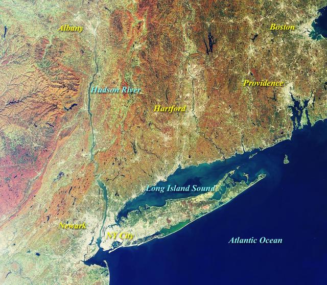
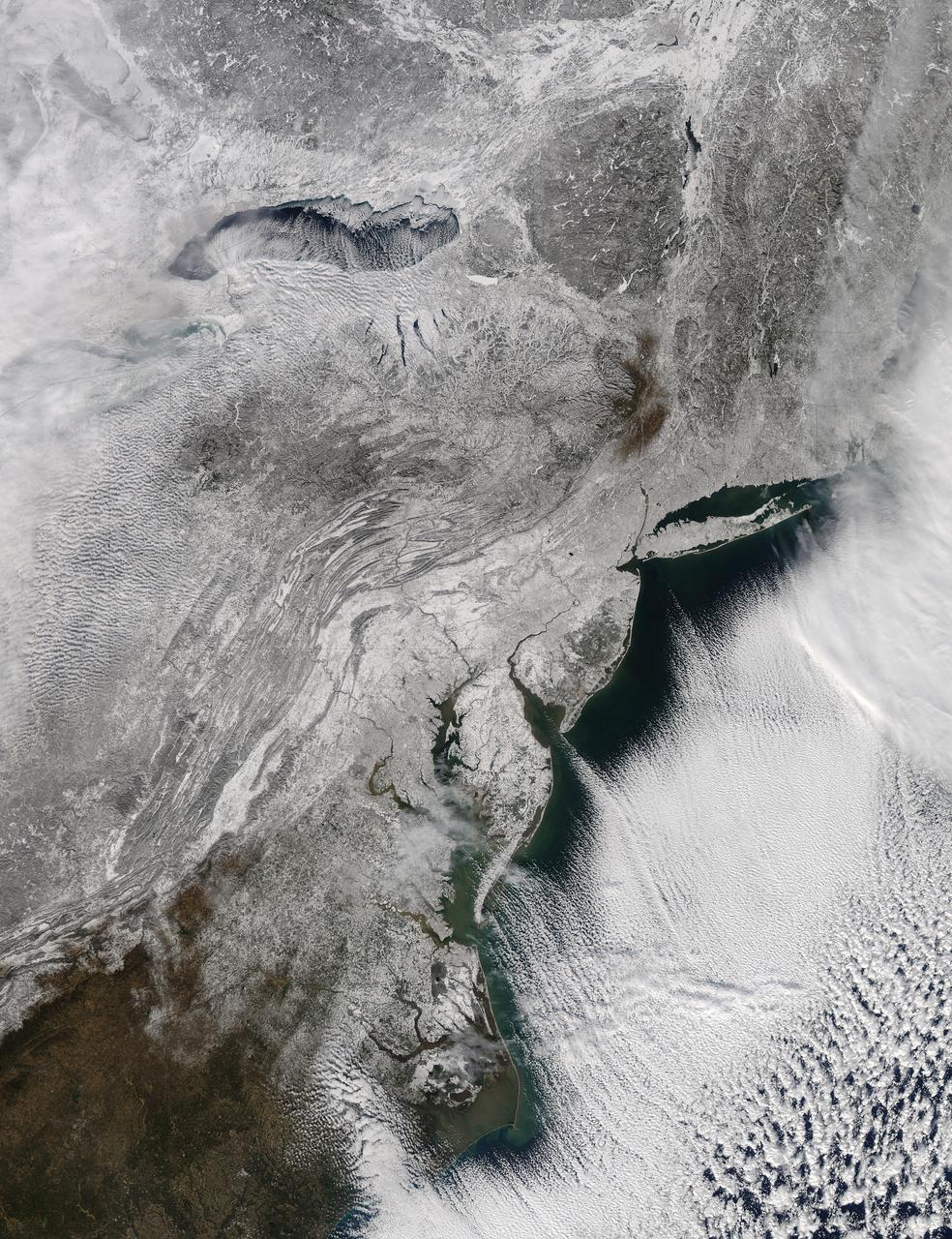
This image from NASA Terra satellite on October 20, 2000, shows New York and Southern New England.

iss074e0300243 (Feb. 2, 2026) --- The wintry landscape of the southern New England region of the United States is seen from the International Space Station as it orbited 262 miles above North America. Temperatures in Boston, Massachusetts, ranged from a low of about 23 degrees Fahrenheit to a high of around 35 degrees when this photograph was taken.
The strong coastal storm currently off the coast of New England will continue to bring strong winds and heavy snow to coastal portions of the Northeast on Wednesday. The storm will move into the Canadian Maritimes by Thursday. This image was taken by GOES East at 17:31 UTC on March 26, 2014. <b><a href="http://goes.gsfc.nasa.gov/" rel="nofollow">Credit: NOAA/NASA GOES Project</a></b> <b><a href="http://www.nasa.gov/audience/formedia/features/MP_Photo_Guidelines.html" rel="nofollow">NASA image use policy.</a></b> <b><a href="http://www.nasa.gov/centers/goddard/home/index.html" rel="nofollow">NASA Goddard Space Flight Center</a></b> enables NASA’s mission through four scientific endeavors: Earth Science, Heliophysics, Solar System Exploration, and Astrophysics. Goddard plays a leading role in NASA’s accomplishments by contributing compelling scientific knowledge to advance the Agency’s mission. <b>Follow us on <a href="http://twitter.com/NASAGoddardPix" rel="nofollow">Twitter</a></b> <b>Like us on <a href="http://www.facebook.com/pages/Greenbelt-MD/NASA-Goddard/395013845897?ref=tsd" rel="nofollow">Facebook</a></b> <b>Find us on <a href="http://instagram.com/nasagoddard?vm=grid" rel="nofollow">Instagram</a></b>
A short drive from Windsor, England, west of London, near the Thames, lies Runnymede meadow. Following John Kennedy's 1963 assassination, the British government commemorated his life by gifting 1.6 ha to the US federal government, making it the only piece of American soil in Britain. The image was acquired June 6, 2016, covers an area of 7.5 by 8 km, and is located at 51.4 degrees north, 0.6 degrees west. https://photojournal.jpl.nasa.gov/catalog/PIA26508

S82-38430 (21 Oct 1982) --- Astronaut Anthony W. England.
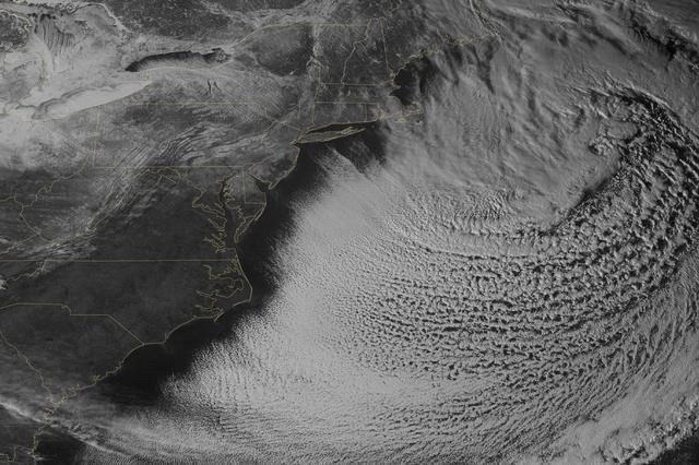
Yet another potent winter storm battered the northeastern United States on February 14-15, 2015. The nor'easter brought 12 to 20 inches (30 to 50 centimeters) of snow across much of eastern New England, along with tropical storm force winds over 60 miles (100 kilometers) per hour. The latest snowfall pushed Boston to its highest monthly total on record—58 inches and counting—and its third highest yearly snow total. This image was acquired by the GOES-East weather satellite at 3:45 p.m. Eastern Standard Time (20:45 Universal Time) on February 15, 2015, as the storm was mostly out to sea. Note the comma-like shape of the nor'easter, which spawned blizzard conditions at coastal locations. The official meteorological definition of a blizzard is three consecutive hours of falling or blowing snow with winds gusting above 35 miles (56 kilometers) per hour and visibility below one-fourth of a mile (0.4 kilometers). As of February 17, the snow depth near Boston was greater than in all but two reported locations in Alaska. It was significantly higher than the notoriously snowy states of Michigan, Wisconsin, and Minnesota. Only Buffalo, New York, had a higher snow pack. On February 16-17, more snow and ice fell across the eastern United States from northern Mississippi all the way to Maine. Read more: <a href="http://1.usa.gov/19wR4LI" rel="nofollow">1.usa.gov/19wR4LI</a> Via: <b><a href="http://www.earthobservatory.nasa.gov/" rel="nofollow"> NASA Earth Observatory</a></b> GOES image courtesy of the NASA/NOAA GOES Project Science team. Terra MODIS image by Jeff Schmaltz, LANCE/EOSDIS Rapid Response at NASA Goddard Space Flight Center. Caption by Mike Carlowicz. <b><a href="http://www.nasa.gov/audience/formedia/features/MP_Photo_Guidelines.html" rel="nofollow">NASA image use policy.</a></b> <b><a href="http://www.nasa.gov/centers/goddard/home/index.html" rel="nofollow">NASA Goddard Space Flight Center</a></b> enables NASA’s mission through four scientific endeavors: Earth Science, Heliophysics, Solar System Exploration, and Astrophysics. Goddard plays a leading role in NASA’s accomplishments by contributing compelling scientific knowledge to advance the Agency’s mission. <b>Follow us on <a href="http://twitter.com/NASAGoddardPix" rel="nofollow">Twitter</a></b> <b>Like us on <a href="http://www.facebook.com/pages/Greenbelt-MD/NASA-Goddard/395013845897?ref=tsd" rel="nofollow">Facebook</a></b> <b>Find us on <a href="http://instagram.com/nasagoddard?vm=grid" rel="nofollow">Instagram</a></b>
The Drakelands Mine (previously known as the Hemerdon Mine) is a historic tungsten and tin mine located northeast of Plymouth, England. Tin and tungsten deposits were discovered in 1867, and the mine operated until 1944. Last year work started to re-open the mine, as it hosts the fourth-largest tungsten and tin deposits in the world. Tungsten has innumerable uses due to its incredible density and high melting temperature. Yet more than 80% of world supply is controlled by China, who has imposed restriction on export of the metal. The image covers an area of 17 by 18.9 km, was acquired June 5, 2013, and is located at 50.4 degrees north, 4 degrees west. http://photojournal.jpl.nasa.gov/catalog/PIA19757
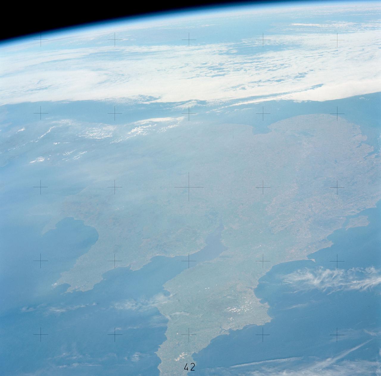
STS060-94-007 (3-11 Feb 1994) --- The Isle of Wight, over 380 square kilometers, is a diamond-shaped island located off the south coast of England. Separated from the mainland by The Solent, a narrow channel of water, the island is a popular resort area due to its scenery and mild climate. Sediment from English Lowland drainage systems, most notably the River Test, is visible entering The Solent and spilling into the English Channel. At the tip of the linear, northwestward inlet is the mouth of the Test and the city of Southampton, discernible as a small patch of lighter gray. Further east is a series of protected bays which are, from west to east: Portsmouth Harbour, Langstone Harbour, and Chichester Harbour. The city of Portsmouth is the location of Great Britain's chief naval station and arsenal. Portsmouth houses numerous ships of past and present glory. Two of the most notable vessels in Portsmouth are the 104-gun Victory, and the remains of the Mary Rose. The renowned HMS Victory, still carried on active duty rolls of the Royal Navy, and the acting Post Ship of the Royal Navy Base Commander, was built in 1765. The HMS Victory was severely damaged and dismasted in battle. A careful inspection of the original film will show the 175-foot long HMS Victory in this frame. According to NASA geologists it is extremely unusual for Portsmouth to be this cloud-free. It has been a site of some interest for many Space Shuttle missions during the past 10 years.
iss072e394484 (Dec. 18, 2024) --- The gleaming New England coast from Massachusetts to Maine is pictured from the International Space Station as it orbited 262 miles above Quebec, Canada.
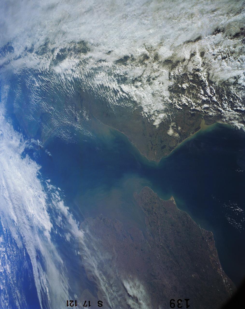
SL2-103-967 (22 June 1973) --- This view of lower New England, (41.5N, 72.0W) shows a rare cloud-free area stretching from northern Long Island across the states of Connecticut, Rhode Island and Massachusetts. The total area covered by this photo is more than 25,000 square miles and includes all of Rhode Island, most of Massachusetts and Connecticut, part of New York and the coastal waters of the Atlantic Ocean. Cape Cod, Boston and the offshore islands are distinctive features. Photo credit: NASA
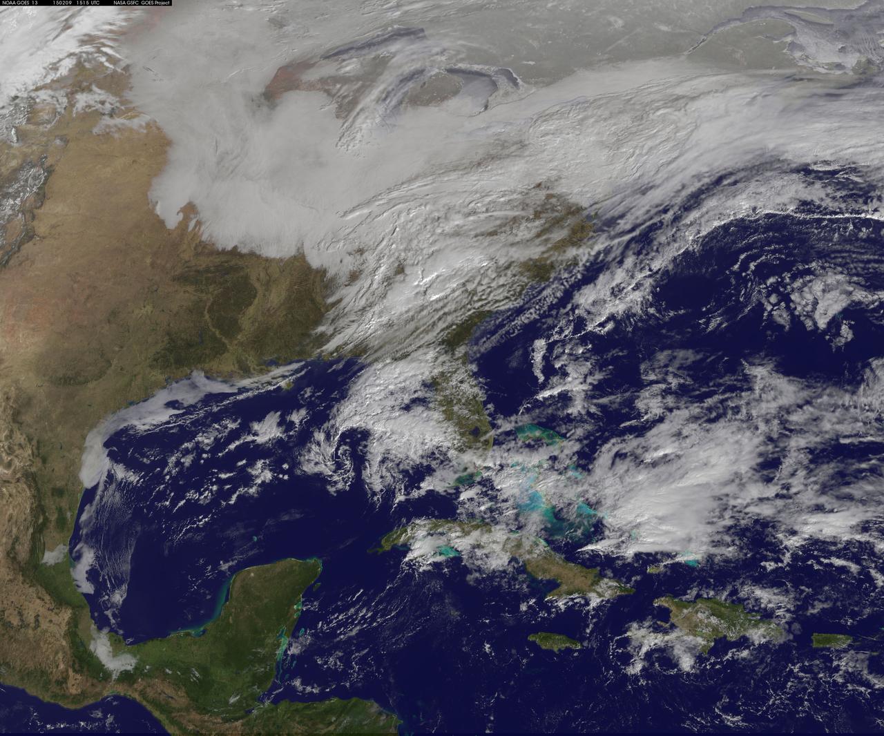
Another large snowstorm affecting New England was dropping more snow on the region and breaking records on February 9, as NOAA's GOES-East satellite captured an image of the clouds associated with the storm system. On Feb. 9, NOAA's National Weather Service in Boston, Massachusetts noted that "The 30-day snowfall total at Boston ending 7 a.m. this morning is 61.6 inches. This exceeds the previous maximum 30 day snowfall total on record at Boston, which was 58.8 inches ending Feb 7 1978." The GOES-East image was created by NASA/NOAA's GOES Project at NASA's Goddard Space Flight Center in Greenbelt, Maryland. It showed a blanket of clouds over the U.S. northeast that stretched down to the Mid-Atlantic where there was no snow on the ground in Washington, D.C. NOAA's National Weather Service Weather Prediction Center provided a look at the extent of the storm system and noted "Heavy snow will impact portions of New York State and New England as the new week begins. Freezing rain will spread from western Pennsylvania to Long Island, with rain for the mid-Atlantic states." The low pressure area bringing the snow to the northeast was located in central Pennsylvania. A cold front extended southward from the low across the Tennessee Valley while a stationary boundary extended eastward from the low across the central mid-Atlantic. To create the image, NASA/NOAA's GOES Project takes the cloud data from NOAA's GOES-East satellite and overlays it on a true-color image of land and ocean created by data from the Moderate Resolution Imaging Spectroradiometer, or MODIS, instrument that flies aboard NASA's Aqua and Terra satellites. Together, those data created the entire picture of the storm. NOAA's GOES satellites provide the kind of continuous monitoring necessary for intensive data analysis. Geostationary describes an orbit in which a satellite is always in the same position with respect to the rotating Earth. This allows GOES to hover continuously over one position on Earth's surface, appearing stationary. As a result, GOES provide a constant vigil for the atmospheric triggers for severe weather conditions such as tornadoes, flash floods, hail storms and hurricanes. For updated information about the storm system, visit NOAA's NWS website: <a href="http://www.weather.gov" rel="nofollow">www.weather.gov</a> For more information about GOES satellites, visit: <a href="http://www.goes.noaa.gov/" rel="nofollow">www.goes.noaa.gov/</a> or goes.gsfc.nasa.gov/ Rob Gutro NASA's Goddard Space Flight Center <b><a href="http://goes.gsfc.nasa.gov/" rel="nofollow">Credit: NOAA/NASA GOES Project</a></b> <b><a href="http://www.nasa.gov/audience/formedia/features/MP_Photo_Guidelines.html" rel="nofollow">NASA image use policy.</a></b> <b><a href="http://www.nasa.gov/centers/goddard/home/index.html" rel="nofollow">NASA Goddard Space Flight Center</a></b> enables NASA’s mission through four scientific endeavors: Earth Science, Heliophysics, Solar System Exploration, and Astrophysics. Goddard plays a leading role in NASA’s accomplishments by contributing compelling scientific knowledge to advance the Agency’s mission. <b>Follow us on <a href="http://twitter.com/NASAGoddardPix" rel="nofollow">Twitter</a></b> <b>Like us on <a href="http://www.facebook.com/pages/Greenbelt-MD/NASA-Goddard/395013845897?ref=tsd" rel="nofollow">Facebook</a></b> <b>Find us on <a href="http://instagram.com/nasagoddard?vm=grid" rel="nofollow">Instagram</a></b>
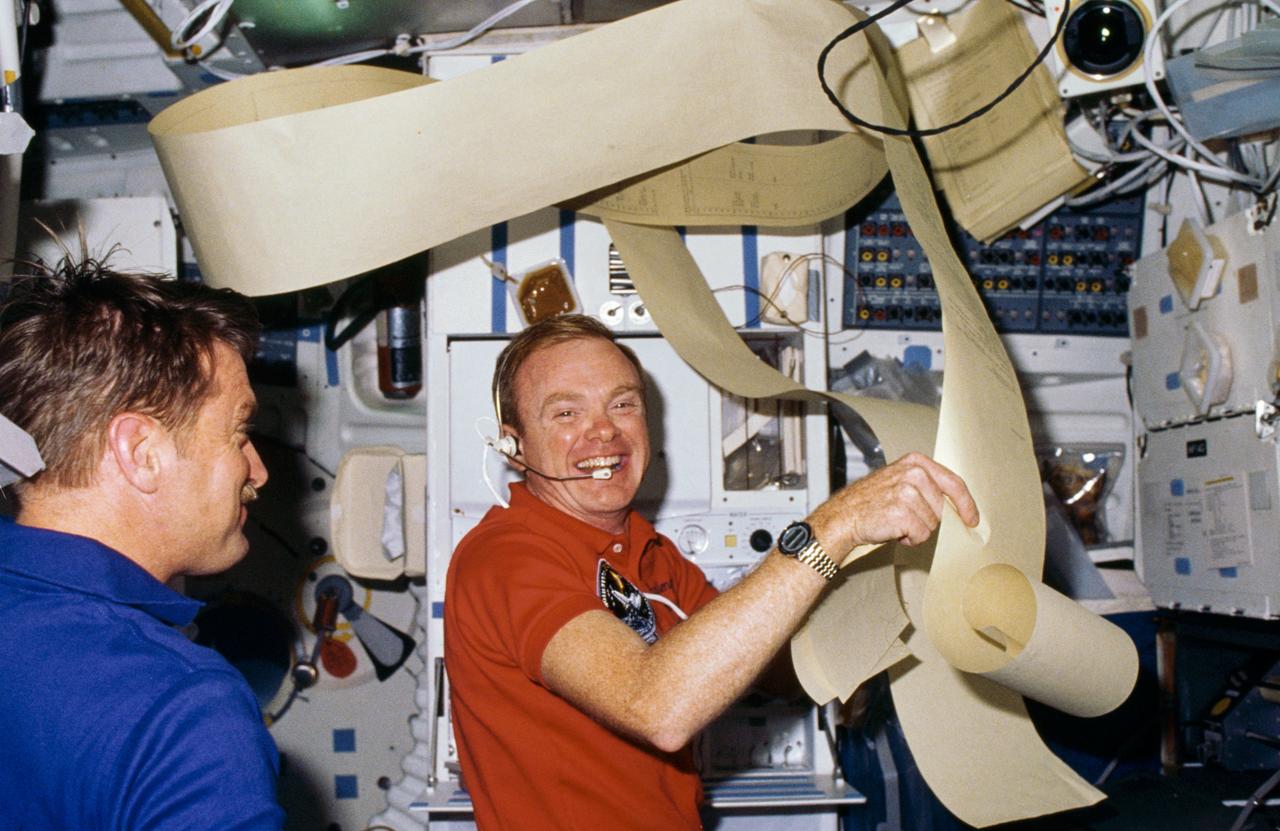
51F-03-024 (29 July-6 Aug 1985) --- Astronauts Anthony W. England, left, and Roy D. Bridges are surrounded by some of the prolific teleprinter copy transmitted from ground controllers to the Earth-orbiting Challenger. Eventually the equivalent of several football fields' length of paper was filled with data from flight controllers.

iss074e0381351 (March 13, 2026) --- London, England, with a metropolitan population of nearly 10 million, is split by the River Thames in this nighttime photograph taken from the International Space Station as it orbited 266 miles above Europe. London’s Heathrow Airport is visible at the bottom left. Credit: NASA/Chris Williams
SL2-05-381 (22 June 1973) --- Boston, MA and the New England Coastline (43.5N, 84.0W) can be seen in this view. The typical rugged rocky coast of Maine is the result of heavy glacial action producing the rocky cliffs, jagged spurs of land and islands that characterize Main's Atlantic Coast. During the last Ice Age, extensive sediments were laid down producing a landscape of rolling hills with rocky outcrops. Photo credit: NASA
![The monster winter storm that brought icing to the U.S. southeast moved northward along the Eastern Seaboard and brought snow, sleet and rain from the Mid-Atlantic to New England on February 13. A new image from NOAA's GOES satellite showed clouds associated with the massive winter storm stretch from the U.S. southeast to the northeast. Data from NOAA's GOES-East satellite taken on Feb. 13 at 1455 UTC/9:45 a.m. EST were made into an image by NASA/NOAA's GOES Project at NASA's Goddard Space Flight Center in Greenbelt, Md. The clouds and fallen snow data from NOAA's GOES-East satellite were overlaid on a true-color image of land and ocean created by data from the Moderate Resolution Imaging Spectroradiometer or MODIS instrument that flies aboard NASA's Aqua and Terra satellites.The image showed that the clouds associated with the storm were blanketing much of the U.S. East Coast. At 3:11 a.m. EST, a surface map issued by the National Weather Service or NWS showed the storm's low pressure area was centered over eastern North Carolina. Since then, the low has continued to track north along the eastern seaboard. By 11 a.m. EST, precipitation from the storm was falling from South Carolina to Maine, according to National Weather Service radar. By 11 a.m. EST, the Washington, D.C. region snow and sleet totals ranged from 3" in far eastern Maryland to over 18" in the northern and western suburbs in Maryland and Virginia. NWS reported that snow, sleet and rain were still falling and more snow is expected as the back side of the low moves into the region. The New York City region remained under an NWS Winter Storm Warning until 6 a.m. on Friday, February 14 and the National Weather Service expects minor coastal impacts Thursday into Friday afternoon. New England was also being battered by the storm. At 10:56 a.m. EST, Barnstable, Mass. on Cape Cod was experiencing rain and winds gusting to 28 mph. An NWS wind advisory is in effect for Cape Cod until 7 p.m. EST. Further north, Portland, Maine was experiencing heavy snow with winds from the northeast at 6 mph. The National Weather Service in Gray, Maine noted "Significant snowfall is likely for much of western Maine and New Hampshire as this storm passes by. There will be a mix or changeover to sleet and freezing rain over southern and coastal sections tonight...before all areas end as a period of snow Friday (Feb. 14) morning." On February 13 at 10 a.m. EST, NOAA's National Weather Service noted "An abundance of Atlantic moisture getting wrapped into the storm will continue to fuel widespread precipitation...which should lift through the Mid-Atlantic States and Northeast Thursday into Friday. A wide swath of heavy snow accumulations are expected with this storm...but air [moving] off the warmer ocean water should change snow over to rain along the coastal areas. Also...a narrow axis of sleet and freezing rain will be possible within the transition zone...which is expected to set up near the I-95 corridor." For updates on local forecasts, watches and warnings, visit NOAA's <a href="http://www.weather.gov" rel="nofollow">www.weather.gov</a> webpage. GOES satellites provide the kind of continuous monitoring necessary for intensive data analysis. Geostationary describes an orbit in which a satellite is always in the same position with respect to the rotating Earth. This allows GOES to hover continuously over one position on Earth's surface, appearing stationary. As a result, GOES provide a constant vigil for the atmospheric "triggers" for severe weather conditions such as tornadoes, flash floods, hail storms and hurricanes. For updated information about the storm system, visit NOAA's WPC website: <a href="http://www.hpc.ncep.noaa.gov/" rel="nofollow">www.hpc.ncep.noaa.gov/</a> For more information about GOES satellites, visit: <a href="http://www.goes.noaa.gov/" rel="nofollow">www.goes.noaa.gov/</a> or <a href="http://goes.gsfc.nasa.gov/" rel="nofollow">goes.gsfc.nasa.gov/</a> Credit: NASA/GSFC/Jeff Schmaltz/MODIS Land Rapid Response Team <b><a href="http://www.nasa.gov/audience/formedia/features/MP_Photo_Guidelines.html" rel="nofollow">NASA image use policy.</a></b> <b><a href="http://www.nasa.gov/centers/goddard/home/index.html" rel="nofollow">NASA Goddard Space Flight Center</a></b> enables NASA’s mission through four scientific endeavors: Earth Science, Heliophysics, Solar System Exploration, and Astrophysics. Goddard plays a leading role in NASA’s accomplishments by contributing compelling scientific knowledge to advance the Agency’s mission. <b>Follow us on <a href="http://twitter.com/NASAGoddardPix" rel="nofollow">Twitter</a></b> <b>Like us on <a href="http://www.facebook.com/pages/Greenbelt-MD/NASA-Goddard/395013845897?ref=tsd" rel="nofollow">Facebook</a></b> <b>Find us on <a href="http://instagram.com/nasagoddard?vm=grid" rel="nofollow">Instagram</a></b>](https://images-assets.nasa.gov/image/GSFC_20171208_Archive_e001229/GSFC_20171208_Archive_e001229~medium.jpg)
The monster winter storm that brought icing to the U.S. southeast moved northward along the Eastern Seaboard and brought snow, sleet and rain from the Mid-Atlantic to New England on February 13. A new image from NOAA's GOES satellite showed clouds associated with the massive winter storm stretch from the U.S. southeast to the northeast. Data from NOAA's GOES-East satellite taken on Feb. 13 at 1455 UTC/9:45 a.m. EST were made into an image by NASA/NOAA's GOES Project at NASA's Goddard Space Flight Center in Greenbelt, Md. The clouds and fallen snow data from NOAA's GOES-East satellite were overlaid on a true-color image of land and ocean created by data from the Moderate Resolution Imaging Spectroradiometer or MODIS instrument that flies aboard NASA's Aqua and Terra satellites.The image showed that the clouds associated with the storm were blanketing much of the U.S. East Coast. At 3:11 a.m. EST, a surface map issued by the National Weather Service or NWS showed the storm's low pressure area was centered over eastern North Carolina. Since then, the low has continued to track north along the eastern seaboard. By 11 a.m. EST, precipitation from the storm was falling from South Carolina to Maine, according to National Weather Service radar. By 11 a.m. EST, the Washington, D.C. region snow and sleet totals ranged from 3" in far eastern Maryland to over 18" in the northern and western suburbs in Maryland and Virginia. NWS reported that snow, sleet and rain were still falling and more snow is expected as the back side of the low moves into the region. The New York City region remained under an NWS Winter Storm Warning until 6 a.m. on Friday, February 14 and the National Weather Service expects minor coastal impacts Thursday into Friday afternoon. New England was also being battered by the storm. At 10:56 a.m. EST, Barnstable, Mass. on Cape Cod was experiencing rain and winds gusting to 28 mph. An NWS wind advisory is in effect for Cape Cod until 7 p.m. EST. Further north, Portland, Maine was experiencing heavy snow with winds from the northeast at 6 mph. The National Weather Service in Gray, Maine noted "Significant snowfall is likely for much of western Maine and New Hampshire as this storm passes by. There will be a mix or changeover to sleet and freezing rain over southern and coastal sections tonight...before all areas end as a period of snow Friday (Feb. 14) morning." On February 13 at 10 a.m. EST, NOAA's National Weather Service noted "An abundance of Atlantic moisture getting wrapped into the storm will continue to fuel widespread precipitation...which should lift through the Mid-Atlantic States and Northeast Thursday into Friday. A wide swath of heavy snow accumulations are expected with this storm...but air [moving] off the warmer ocean water should change snow over to rain along the coastal areas. Also...a narrow axis of sleet and freezing rain will be possible within the transition zone...which is expected to set up near the I-95 corridor." For updates on local forecasts, watches and warnings, visit NOAA's <a href="http://www.weather.gov" rel="nofollow">www.weather.gov</a> webpage. GOES satellites provide the kind of continuous monitoring necessary for intensive data analysis. Geostationary describes an orbit in which a satellite is always in the same position with respect to the rotating Earth. This allows GOES to hover continuously over one position on Earth's surface, appearing stationary. As a result, GOES provide a constant vigil for the atmospheric "triggers" for severe weather conditions such as tornadoes, flash floods, hail storms and hurricanes. For updated information about the storm system, visit NOAA's WPC website: <a href="http://www.hpc.ncep.noaa.gov/" rel="nofollow">www.hpc.ncep.noaa.gov/</a> For more information about GOES satellites, visit: <a href="http://www.goes.noaa.gov/" rel="nofollow">www.goes.noaa.gov/</a> or <a href="http://goes.gsfc.nasa.gov/" rel="nofollow">goes.gsfc.nasa.gov/</a> Credit: NASA/GSFC/Jeff Schmaltz/MODIS Land Rapid Response Team <b><a href="http://www.nasa.gov/audience/formedia/features/MP_Photo_Guidelines.html" rel="nofollow">NASA image use policy.</a></b> <b><a href="http://www.nasa.gov/centers/goddard/home/index.html" rel="nofollow">NASA Goddard Space Flight Center</a></b> enables NASA’s mission through four scientific endeavors: Earth Science, Heliophysics, Solar System Exploration, and Astrophysics. Goddard plays a leading role in NASA’s accomplishments by contributing compelling scientific knowledge to advance the Agency’s mission. <b>Follow us on <a href="http://twitter.com/NASAGoddardPix" rel="nofollow">Twitter</a></b> <b>Like us on <a href="http://www.facebook.com/pages/Greenbelt-MD/NASA-Goddard/395013845897?ref=tsd" rel="nofollow">Facebook</a></b> <b>Find us on <a href="http://instagram.com/nasagoddard?vm=grid" rel="nofollow">Instagram</a></b>
![The monster winter storm that brought icing to the U.S. southeast moved northward along the Eastern Seaboard and brought snow, sleet and rain from the Mid-Atlantic to New England on February 13. A new image from NOAA's GOES satellite showed clouds associated with the massive winter storm stretch from the U.S. southeast to the northeast. Data from NOAA's GOES-East satellite taken on Feb. 13 at 1455 UTC/9:45 a.m. EST were made into an image by NASA/NOAA's GOES Project at NASA's Goddard Space Flight Center in Greenbelt, Md. The clouds and fallen snow data from NOAA's GOES-East satellite were overlaid on a true-color image of land and ocean created by data from the Moderate Resolution Imaging Spectroradiometer or MODIS instrument that flies aboard NASA's Aqua and Terra satellites.The image showed that the clouds associated with the storm were blanketing much of the U.S. East Coast. At 3:11 a.m. EST, a surface map issued by the National Weather Service or NWS showed the storm's low pressure area was centered over eastern North Carolina. Since then, the low has continued to track north along the eastern seaboard. By 11 a.m. EST, precipitation from the storm was falling from South Carolina to Maine, according to National Weather Service radar. By 11 a.m. EST, the Washington, D.C. region snow and sleet totals ranged from 3" in far eastern Maryland to over 18" in the northern and western suburbs in Maryland and Virginia. NWS reported that snow, sleet and rain were still falling and more snow is expected as the back side of the low moves into the region. The New York City region remained under an NWS Winter Storm Warning until 6 a.m. on Friday, February 14 and the National Weather Service expects minor coastal impacts Thursday into Friday afternoon. New England was also being battered by the storm. At 10:56 a.m. EST, Barnstable, Mass. on Cape Cod was experiencing rain and winds gusting to 28 mph. An NWS wind advisory is in effect for Cape Cod until 7 p.m. EST. Further north, Portland, Maine was experiencing heavy snow with winds from the northeast at 6 mph. The National Weather Service in Gray, Maine noted "Significant snowfall is likely for much of western Maine and New Hampshire as this storm passes by. There will be a mix or changeover to sleet and freezing rain over southern and coastal sections tonight...before all areas end as a period of snow Friday (Feb. 14) morning." On February 13 at 10 a.m. EST, NOAA's National Weather Service noted "An abundance of Atlantic moisture getting wrapped into the storm will continue to fuel widespread precipitation...which should lift through the Mid-Atlantic States and Northeast Thursday into Friday. A wide swath of heavy snow accumulations are expected with this storm...but air [moving] off the warmer ocean water should change snow over to rain along the coastal areas. Also...a narrow axis of sleet and freezing rain will be possible within the transition zone...which is expected to set up near the I-95 corridor." For updates on local forecasts, watches and warnings, visit NOAA's <a href="http://www.weather.gov" rel="nofollow">www.weather.gov</a> webpage. GOES satellites provide the kind of continuous monitoring necessary for intensive data analysis. Geostationary describes an orbit in which a satellite is always in the same position with respect to the rotating Earth. This allows GOES to hover continuously over one position on Earth's surface, appearing stationary. As a result, GOES provide a constant vigil for the atmospheric "triggers" for severe weather conditions such as tornadoes, flash floods, hail storms and hurricanes. For updated information about the storm system, visit NOAA's WPC website: <a href="http://www.hpc.ncep.noaa.gov/" rel="nofollow">www.hpc.ncep.noaa.gov/</a> For more information about GOES satellites, visit: <a href="http://www.goes.noaa.gov/" rel="nofollow">www.goes.noaa.gov/</a> or <a href="http://goes.gsfc.nasa.gov/" rel="nofollow">goes.gsfc.nasa.gov/</a> Credit: NASA/GSFC/Jeff Schmaltz/MODIS Land Rapid Response Team <b><a href="http://www.nasa.gov/audience/formedia/features/MP_Photo_Guidelines.html" rel="nofollow">NASA image use policy.</a></b> <b><a href="http://www.nasa.gov/centers/goddard/home/index.html" rel="nofollow">NASA Goddard Space Flight Center</a></b> enables NASA’s mission through four scientific endeavors: Earth Science, Heliophysics, Solar System Exploration, and Astrophysics. Goddard plays a leading role in NASA’s accomplishments by contributing compelling scientific knowledge to advance the Agency’s mission. <b>Follow us on <a href="http://twitter.com/NASAGoddardPix" rel="nofollow">Twitter</a></b> <b>Like us on <a href="http://www.facebook.com/pages/Greenbelt-MD/NASA-Goddard/395013845897?ref=tsd" rel="nofollow">Facebook</a></b> <b>Find us on <a href="http://instagram.com/nasagoddard?vm=grid" rel="nofollow">Instagram</a></b>](https://images-assets.nasa.gov/image/GSFC_20171208_Archive_e001228/GSFC_20171208_Archive_e001228~medium.jpg)
The monster winter storm that brought icing to the U.S. southeast moved northward along the Eastern Seaboard and brought snow, sleet and rain from the Mid-Atlantic to New England on February 13. A new image from NOAA's GOES satellite showed clouds associated with the massive winter storm stretch from the U.S. southeast to the northeast. Data from NOAA's GOES-East satellite taken on Feb. 13 at 1455 UTC/9:45 a.m. EST were made into an image by NASA/NOAA's GOES Project at NASA's Goddard Space Flight Center in Greenbelt, Md. The clouds and fallen snow data from NOAA's GOES-East satellite were overlaid on a true-color image of land and ocean created by data from the Moderate Resolution Imaging Spectroradiometer or MODIS instrument that flies aboard NASA's Aqua and Terra satellites.The image showed that the clouds associated with the storm were blanketing much of the U.S. East Coast. At 3:11 a.m. EST, a surface map issued by the National Weather Service or NWS showed the storm's low pressure area was centered over eastern North Carolina. Since then, the low has continued to track north along the eastern seaboard. By 11 a.m. EST, precipitation from the storm was falling from South Carolina to Maine, according to National Weather Service radar. By 11 a.m. EST, the Washington, D.C. region snow and sleet totals ranged from 3" in far eastern Maryland to over 18" in the northern and western suburbs in Maryland and Virginia. NWS reported that snow, sleet and rain were still falling and more snow is expected as the back side of the low moves into the region. The New York City region remained under an NWS Winter Storm Warning until 6 a.m. on Friday, February 14 and the National Weather Service expects minor coastal impacts Thursday into Friday afternoon. New England was also being battered by the storm. At 10:56 a.m. EST, Barnstable, Mass. on Cape Cod was experiencing rain and winds gusting to 28 mph. An NWS wind advisory is in effect for Cape Cod until 7 p.m. EST. Further north, Portland, Maine was experiencing heavy snow with winds from the northeast at 6 mph. The National Weather Service in Gray, Maine noted "Significant snowfall is likely for much of western Maine and New Hampshire as this storm passes by. There will be a mix or changeover to sleet and freezing rain over southern and coastal sections tonight...before all areas end as a period of snow Friday (Feb. 14) morning." On February 13 at 10 a.m. EST, NOAA's National Weather Service noted "An abundance of Atlantic moisture getting wrapped into the storm will continue to fuel widespread precipitation...which should lift through the Mid-Atlantic States and Northeast Thursday into Friday. A wide swath of heavy snow accumulations are expected with this storm...but air [moving] off the warmer ocean water should change snow over to rain along the coastal areas. Also...a narrow axis of sleet and freezing rain will be possible within the transition zone...which is expected to set up near the I-95 corridor." For updates on local forecasts, watches and warnings, visit NOAA's <a href="http://www.weather.gov" rel="nofollow">www.weather.gov</a> webpage. GOES satellites provide the kind of continuous monitoring necessary for intensive data analysis. Geostationary describes an orbit in which a satellite is always in the same position with respect to the rotating Earth. This allows GOES to hover continuously over one position on Earth's surface, appearing stationary. As a result, GOES provide a constant vigil for the atmospheric "triggers" for severe weather conditions such as tornadoes, flash floods, hail storms and hurricanes. For updated information about the storm system, visit NOAA's WPC website: <a href="http://www.hpc.ncep.noaa.gov/" rel="nofollow">www.hpc.ncep.noaa.gov/</a> For more information about GOES satellites, visit: <a href="http://www.goes.noaa.gov/" rel="nofollow">www.goes.noaa.gov/</a> or <a href="http://goes.gsfc.nasa.gov/" rel="nofollow">goes.gsfc.nasa.gov/</a> Credit: NASA/GSFC/Jeff Schmaltz/MODIS Land Rapid Response Team <b><a href="http://www.nasa.gov/audience/formedia/features/MP_Photo_Guidelines.html" rel="nofollow">NASA image use policy.</a></b> <b><a href="http://www.nasa.gov/centers/goddard/home/index.html" rel="nofollow">NASA Goddard Space Flight Center</a></b> enables NASA’s mission through four scientific endeavors: Earth Science, Heliophysics, Solar System Exploration, and Astrophysics. Goddard plays a leading role in NASA’s accomplishments by contributing compelling scientific knowledge to advance the Agency’s mission. <b>Follow us on <a href="http://twitter.com/NASAGoddardPix" rel="nofollow">Twitter</a></b> <b>Like us on <a href="http://www.facebook.com/pages/Greenbelt-MD/NASA-Goddard/395013845897?ref=tsd" rel="nofollow">Facebook</a></b> <b>Find us on <a href="http://instagram.com/nasagoddard?vm=grid" rel="nofollow">Instagram</a></b>

iss074e0405029 (March 19, 2026) --- London, England, with a metropolitan population of nearly 10 million, is split by the River Thames in this nighttime photograph taken from the International Space Station as it orbited 265 miles above Europe. London’s two main airports feature prominently, with Heathrow Airport at the bottom and London Gatwick Airport at the far right. Credit: NASA/Jessica Meir
iss072e186812 (Nov. 14, 2024) --- The city lights along the New England coast of the United States including New Haven, Connecticut; Providence, Rhode Island; and Boston, Massachusetts, are pictured from the United States as it orbited 254 miles above the Atlantic Ocean.
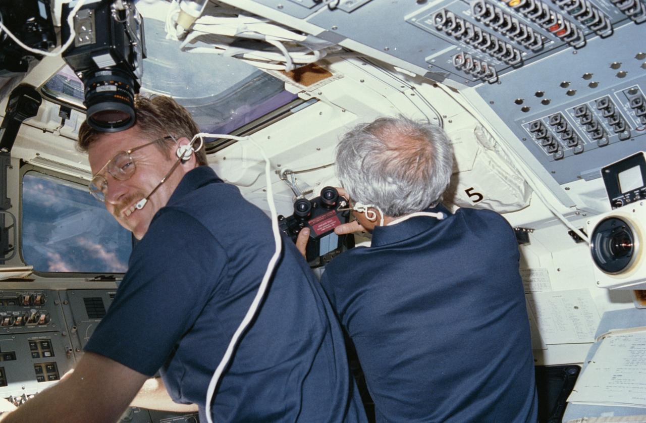
51F-05-003 (29 July-6 Aug 1985) --- Astronaut Anthony W. England, 51-F mission specialist, talks to ground controllers in Houston from the flight deck of the Earth-orbiting Challenger while Payload Specialist John-David Bartoe prepares to use binoculars through aft flight deck windows.
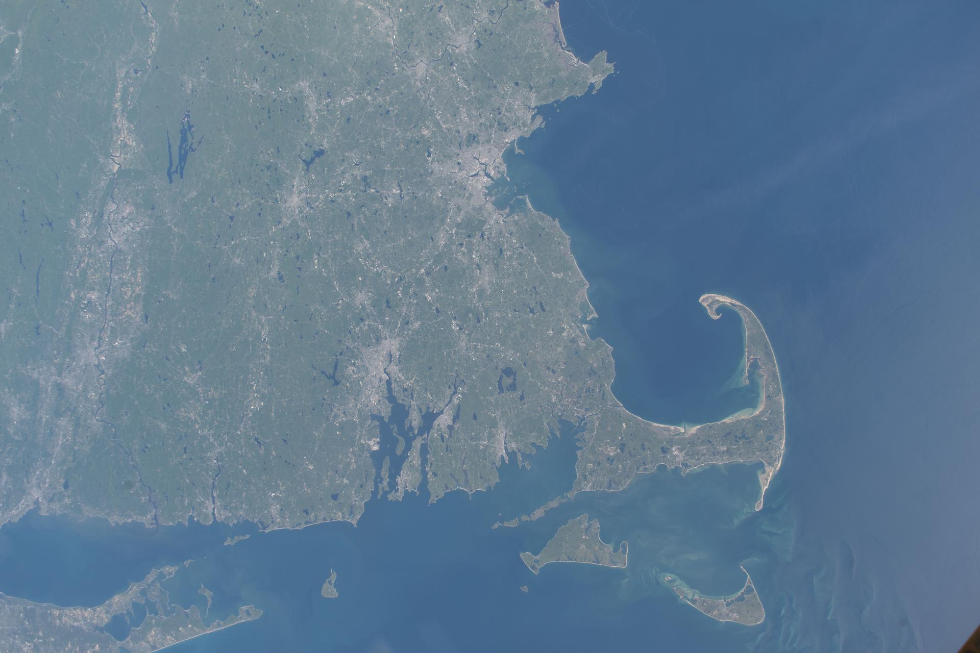
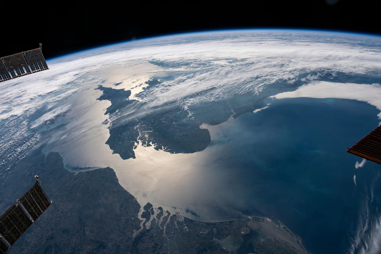
iss074e0671775 (June 4, 2026) --- Massachusetts’ Cape Cod peninsula and the southern New England coastline extending from Rhode Island to Connecticut are featured prominently in this photograph from the International Space Station as it orbited 261 miles above the Atlantic Ocean. Credit: NASA/Chris Williams
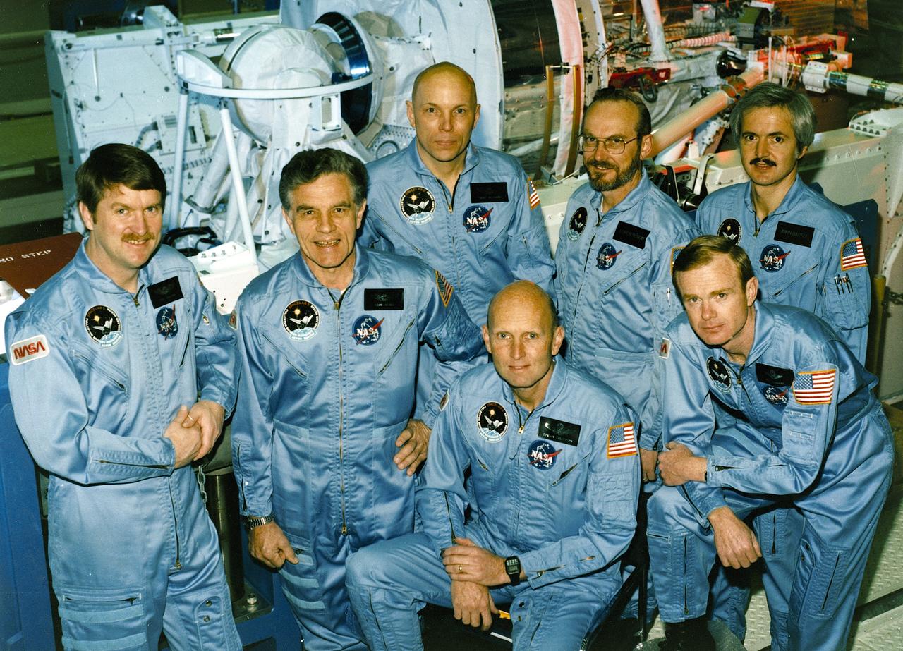
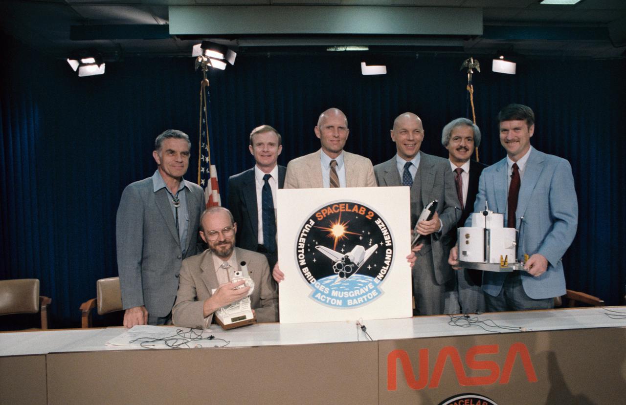
The crew assigned to the STS-51F mission included (kneeling left to right) Gordon Fullerton, commander; and Roy D. Bridges, pilot. Standing, left to right, are mission specialists Anthony W. England, Karl J. Henize, and F. Story Musgrave; and payload specialists Loren W. Acton, and John-David F. Bartoe. Launched aboard the Space Shuttle Challenger on July 29, 1985 at 5:00:00 pm (EDT), the STS-51F mission’s primary payload was the Spacelab-2.
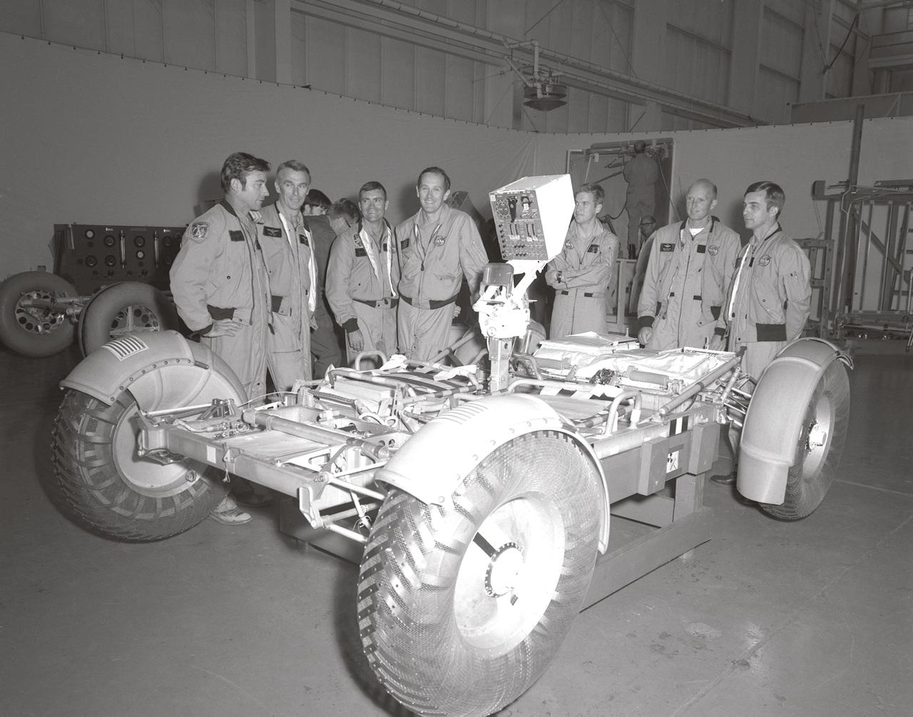
In this November 1971 photograph, (from left to right) Astronauts John Young, Eugene Cernan, Charles Duke, Fred Haise, Anthony England, Charles Fullerton, and Donald Peterson await deployment tests of the Lunar Roving Vehicle (LRV) qualification test unit in building 4649 at the Marshall Space Flight Center (MSFC). The LRV, developed under the direction of the MSFC, was designed to allow Apollo astronauts a greater range of mobility on the lunar surface during the last three lunar exploration missions; Apollo 15, Apollo 16, and Apollo 17.
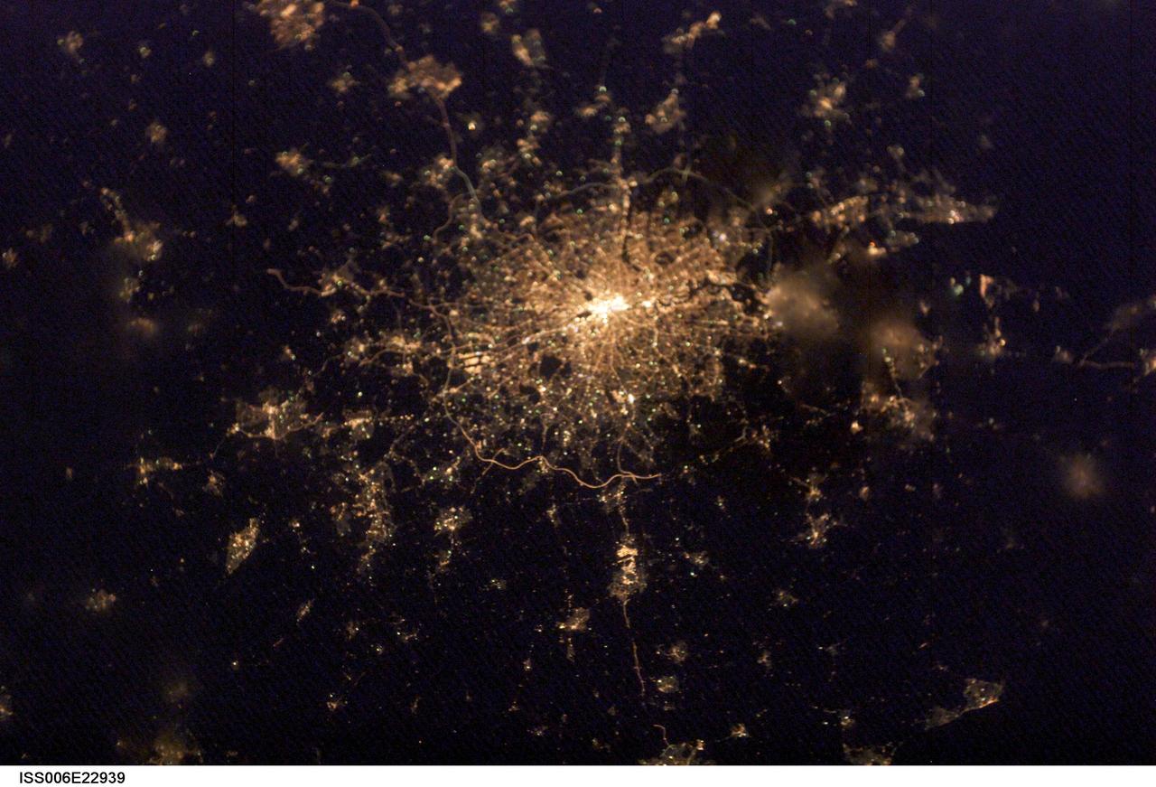
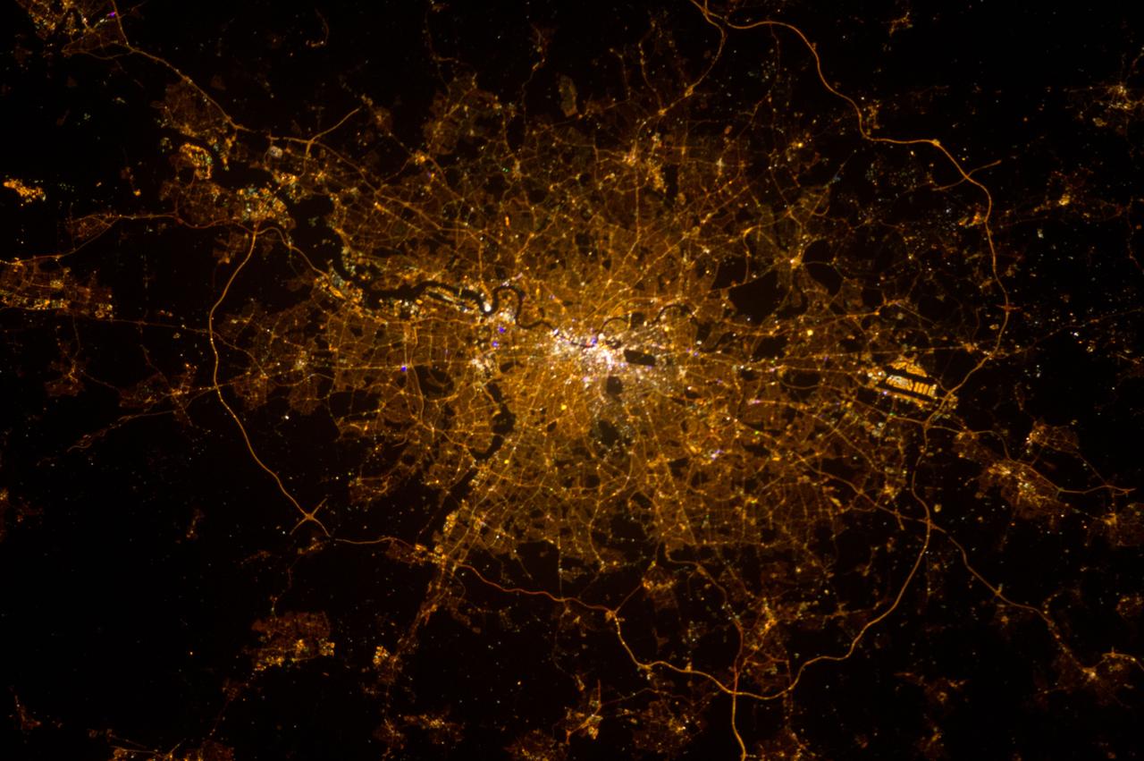
ISS006-E-22939 (4 February 2003) --- City lights of London, England were captured with a digital still camera by one of the Expedition Six crewmembers on the International Space Station (ISS). This nighttime view of the British capital shows the city;s urban density and infrastructure as highlighted by electrical lighting. Beyond lie isolated bright areas marking the numerous smaller cities and towns of the region and as far southeast as Hastings on the coast. London;s two major airports, Heathrow and Gatwick, are visible to the south of the city.
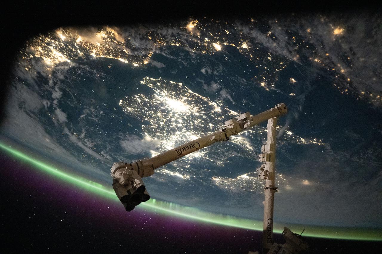
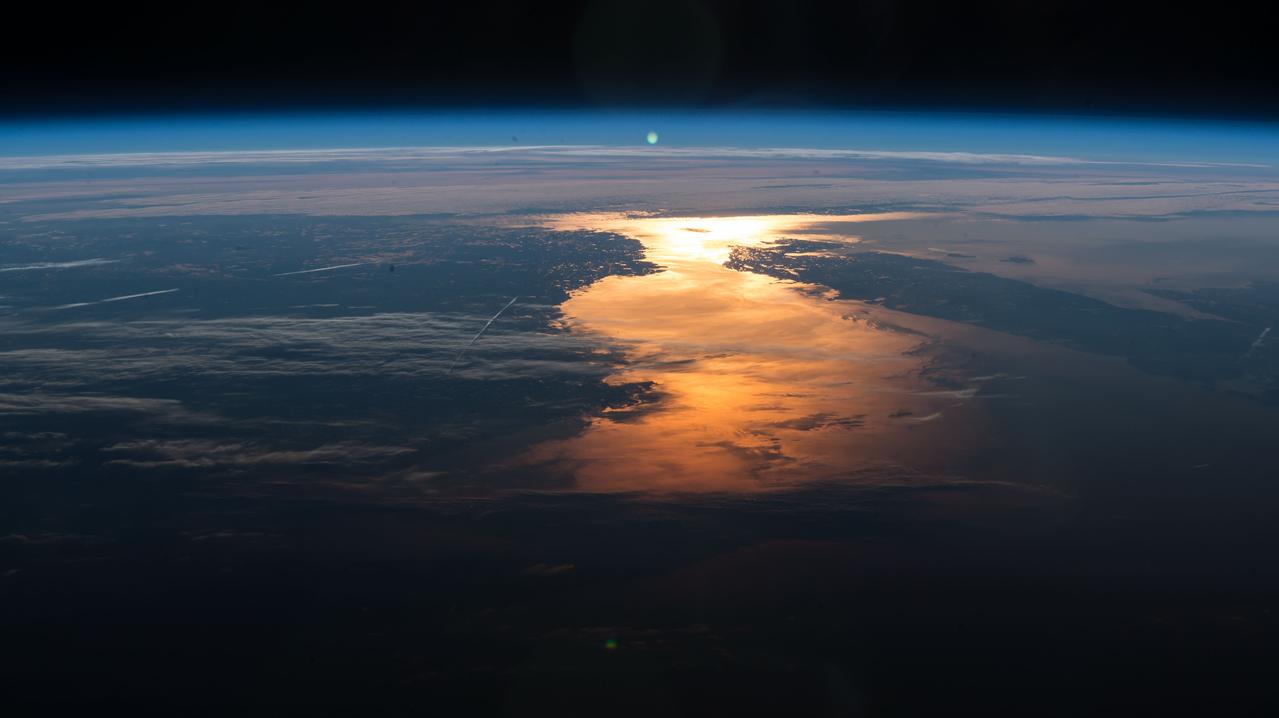
iss073e0698351 (Sept. 13, 2025) --- The English Channel separates the sparkling nighttime coasts of France and England highlighted by an aurora crowning Earth's atmosphere. The sprawling city lights of London are seen at center, while the coastal cities of northern Europe including Amsterdam can be seen at top left. In the foreground, is the Canadarm2 robotic arm. The International Space Station was orbiting 263 miles above France at approximately 11:38 p.m. local time when this photograph was taken.

NASA Administrator Charles Bolden speaks with young professionals about their project on New England water resources during the annual DEVELOP Earth Science Application Showcase at NASA headquarters Tuesday, August 5, 2014. The Earth Science Applications Showcase highlights the work of over 150 participants in the 10-week DEVELOP program that started in June. The DEVELOP Program bridges the gap between NASA Earth science and society, building capacity in both its participants and partner organizations, to better prepare them to handle the challenges that face our society and future generations. Photo Credit: (NASA/Aubrey Gemignani)
STS058-105-016 (18 Oct-1 Nov 1993) --- This photograph includes much of the heart of New England, stretching from Boston and Boston Harbor (lower left) across New Hampshire and Vermont to Lake Champlain (upper left), and up to southern Maine (Portland is just off the photo at right center). The colors in this photograph are less vivid than those in STS-58-81-038, because the color changes on the deciduous trees in central and northern New England were past their peak when this photograph was taken. North of Boston flows the Merrimack River (which forms part of the state boundary between Massachusetts and New Hampshire). It is delineated by the small industrial towns (Concord, Manchester, Nashua, Lowell) which grew up on its banks. The White Mountains of New Hampshire are seen near the center, and Mt. Washington (6,288 feet) is capped with snow.
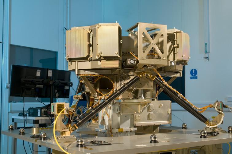
The Mid-Infrared Instrument, a component of NASA James Webb Space Telescope, underwent alignment testing at the Science and Technology Facilities Council Rutherford Appleton Laboratory Space in Oxfordshire, England.
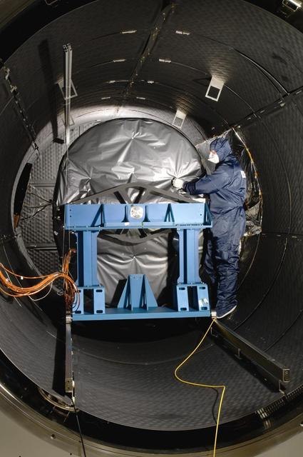
The Mid-Infrared Instrument, a component of NASA James Webb Space Telescope, underwent testing inside the thermal space test chamber at the Science and Technology Facilities Council Rutherford Appleton Laboratory Space in Oxfordshire, England.
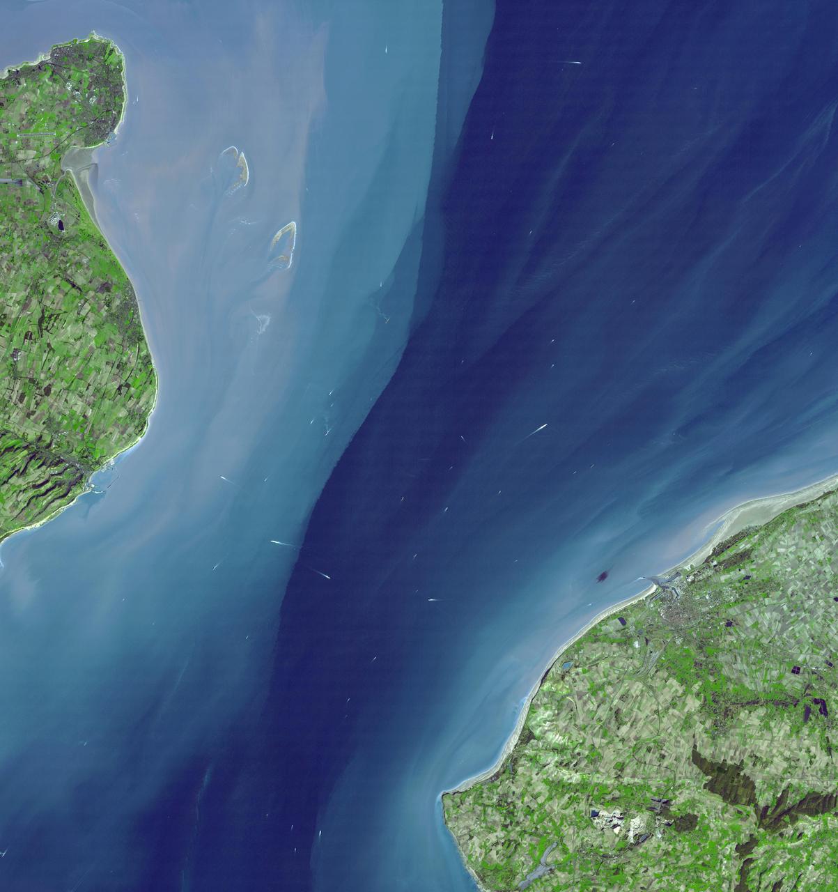
The Channel Tunnel is a 50.5 km-long rail tunnel beneath the English Channel at the Straits of Dover. It connects Dover, Kent in England with Calais, northern France. This image was acquired by NASA Terra spacecraft.
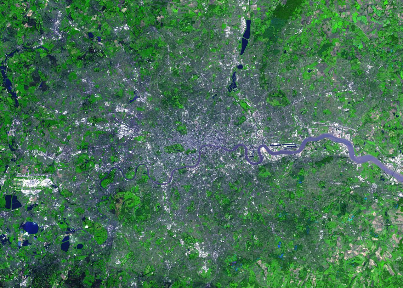
For almost 2,000 years, the River Thames has served as the life force of London, capital of the United Kingdom and one of the world's most famous cities. In AD 43 the Romans established the trading settlement of Londinium at a favorable crossing point on the river. The Romans remained until the 5th century, when the city came under Saxon control. The early 17th century saw enormous growth, but the deadly plague of 1664 and 1665 ravaged the population, and in the following year the Great Fire, which burned for four days, destroyed most of the city. A public transportation system and other city services in the early 19th century eased many of the increasing urban problems of the burgeoning capital of the wealthy British Empire. After coping with the devastating effects of bombing during World War II and the gradual dismantling of the empire, London today thrives as a vital modern metropolis. London is one of 100 cities being studied using ASTER data to map and monitor urban use patterns and growth. This image was acquired on October 12, 2001 by the Advanced Spaceborne Thermal Emission and Reflection Radiometer (ASTER) on NASA's Terra satellite. With its 14 spectral bands from the visible to the thermal infrared wavelength region, and its high spatial resolution of 15 to 90 meters (about 50 to 300 feet), ASTER images Earth to map and monitor the changing surface of our planet. http://photojournal.jpl.nasa.gov/catalog/PIA04301
Earth Observation taken during a day pass by the Expedition 40 crew aboard the International Space Station (ISS). Folder lists this as: England.
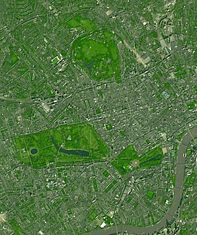
Three of London's many parks are found north of the Thames River. Regent's Park, at the top of the image, was originally a royal hunting ground; now it includes the London Zoo. Hyde Park, in the middle-left of the image, is the largest of the four royal parks, and was established by Henry VIII in 1536; it opened to the public in 1637. Buckingham Palace Garden, at the lower-right of the image, is the largest private garden in London. Today's garden was designed in 1825 under the reign of George IV. Summer garden parties see over 20,000 guests welcomed into the royal garden each summer. The image was acquired September 8, 2021. Covers an area of 5.8 by 6.9 km, and is located at 0.2 degrees west, 51.5 degrees north. https://photojournal.jpl.nasa.gov/catalog/PIA25706
STS068-234-044 (30 September-11 October 1994) --- From the wetlands in Maryland to the nation's capital and onto Baltimore, this 70mm photograph from the Space Shuttle Endeavour shows some details of the historic Chesapeake Bay and Potomac River area. With the rather low altitude of Endeavour at 115 nautical miles, features as small as Kennedy Memorial Stadium and Andrews Air Force Base are clearly seen.
iss071e485735 (Aug. 12, 2024) --- The First Quarter Moon is pictured above Earth's horizon from the International Space Station as it orbited 263 miles above the English Channel in between France and England.
iss063e002750 (April 23, 2020) --- The Rhine–Meuse–Scheldt delta, a river delta in the Netherlands, is pictured from the International Space Station as it orbited off the east coast of England.
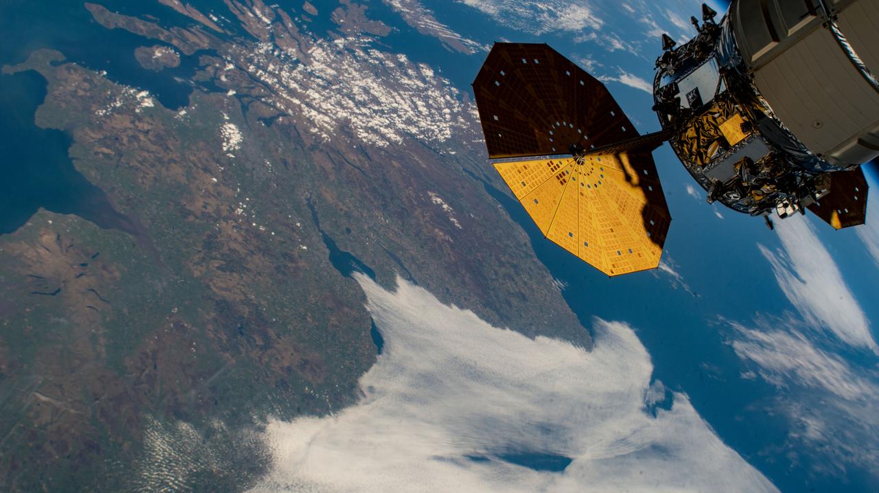
iss067e022350 (April 20, 2022) --- The International Space Station orbits 261 miles above England with Northrop Grumman's Cygnus space freighter pictured in the upper right foreground.
iss056e084656 (June 27, 2018) --- The Canary Wharf financial district, London City Airport and the River Thames in east London, England are pictured as the International Space Station was orbiting across the English Channel.

iss065e385457 (Sept. 15, 2021) --- The International Space Station was orbiting 265 miles above the north Atlantic Ocean when an Expedition 65 crew member captured this photograph of the city lights of England, The Netherlands, Belgium and France.
iss063e002730 (April 23, 2020) --- The Rhine–Meuse–Scheldt delta, a river delta in the Netherlands, is pictured from the International Space Station as it orbited off the east coast of England.
Earth Observation taken during a day pass by the Expedition 40 crew aboard the International Space Station (ISS). Folder lists this as: Heading towards England and sun glint.
iss056e077502 (July 5, 2018) --- The International Space Station orbited over New England and across Canada capturing the Sun's glint on the North Atlantic Ocean just off the North American coast..
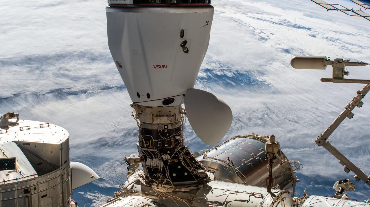
iss066e096807 (Dec. 24, 2021) --- The SpaceX Cargo Dragon vehicle is pictured docked to the Harmony module's space-facing port on the International Space Station as it orbited 265 miles above southern England.
iss065e083895 (June 1, 2021) --- The sun's glint beams across the English Channel and the North Sea in between southern England and the coasts of France, Belgium and The Netherlands, in this photograph from the International Space Station as it orbited 263 miles above.
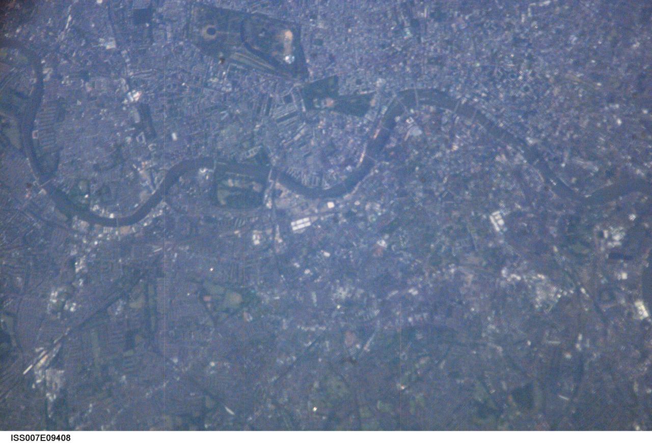
ISS007-E-09408 (5 July 2003) --- This nadir view of London, England, was downlinked from the International Space Station by one of the Expedition 7 crew members. A number of man-made landmarks are visible in the digital image, along with easily recognizable natural features, such as the River Thames, seen winding primarily in an East-West direction across the frame. The crew members could not help but be thinking of the Grand Slam Tournament being played at this time at the Wimbledon All England Tennis Club located in the south west of London. Wimbledon is just out of frame below the southwards bulge of the Thames.
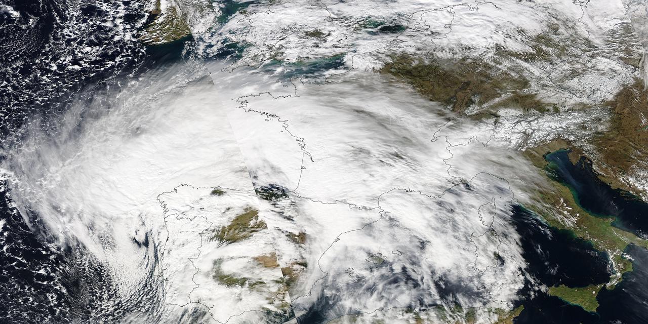
Image acquired February 27, 2010: An extratropical cyclone named Xynthia brought hurricane-force winds and high waves to Western Europe at the end of February 2010, CNN reported. Winds as fast as 200 kilometers (125 miles) per hour reached as far inland as Paris, and at the storm’s peak, hurricane-force winds extended from Portugal to the Netherlands. Hundreds of people had to take refuge from rising waters on their rooftops. By March 1, at least 58 people had died, some of them struck by falling trees. Most of the deaths occurred in France, but the storm also caused casualties in England, Germany, Belgium, Spain, and Portugal. The Moderate Resolution Imaging Spectroradiometer (MODIS) on NASA’s Aqua satellite captured this image of Western Europe, acquired in two separate overpasses on February 27, 2010. MODIS captured the eastern half of the image around 10:50 UTC, and the western half about 12:30 UTC. Forming a giant comma shape, clouds stretch from the Atlantic Ocean to northern Italy. NASA image courtesy MODIS Rapid Response Team at NASA Goddard Space Flight Center. Caption by Michon Scott. Instrument: Aqua - MODIS For more information related to this image go to: <a href="http://earthobservatory.nasa.gov/NaturalHazards/view.php?id=42881" rel="nofollow">earthobservatory.nasa.gov/NaturalHazards/view.php?id=42881</a>
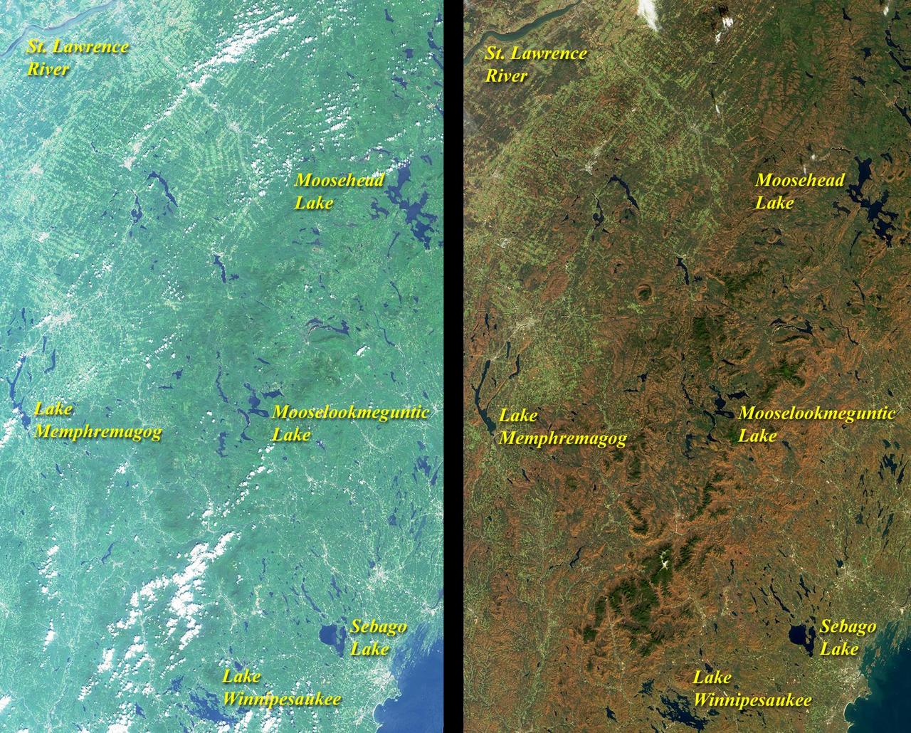
These images from NASA Terra satellite include eastern Vermont, New Hampshire, and western Maine, as well as the southeastern corner of Quebec province between August and October, 2000.
41G-121-138 (5-13 Oct 1984) --- A view of the Earth's horizon featuring France and England. The Strait of Dover and the English channel are visible behind the tail (vertical stabilizer) of Challenger. The remote manipulator system (RMS arm rests in its "stow" position at upper left corner.
ISS042E037846 (12/13/2015) --- European Space Agency (ESA) Astronaut Samantha Cristoforetti on the International Space Station took this Earth observation picture of England, the Baltic area, and the Persian Gulf with a golden aurora on Dec. 15, 2014. Samantha is a flight engineer with Expedition 42.
ISS042E037793 (12/13/2014) --- ESA (European Space Station) astronaut Samantha Cristoforetti on board the International Space Station Dec. 13th, 2014 took this night exposure of the Earth showing an Aurora with city lights over the Baltic countries of northern Europe and England.

51F-06-017 (29 July-6 Aug. 1985) --- Crew portrait with sunglasses. C. Gordon Fullerton's head is at center. Others (bottom, l.-r.) are Roy D. Bridges, F. Story Musgrave and John David Bartoe; and (top) Karl J. Henize, Loren W. Acton and Anthony W. England.

Ames Director William 'Bill' Ballhaus (center left) joins visitor Sir Jeffrey Pope from Royla Aircraft Industry, England (center right) at the NAS Facility Cray 2 computer with Ron Deiss, NAS Deputy Manager (L) and Vic Peterson, Ames Deputy Director (R).
iss068e017867 (Oct. 1, 2022) --- NASA astronaut and Expedition 68 Flight Engineer Frank Rubio is pictured inside the cupola, the International Space Station's "window to the world," as the orbiting lab flew 263 miles above southeastern England. Credit: NASA/Frank Rubio
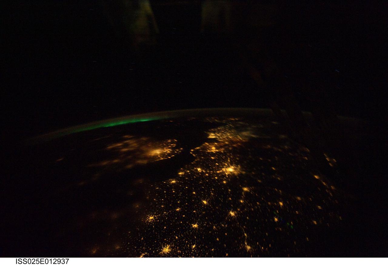
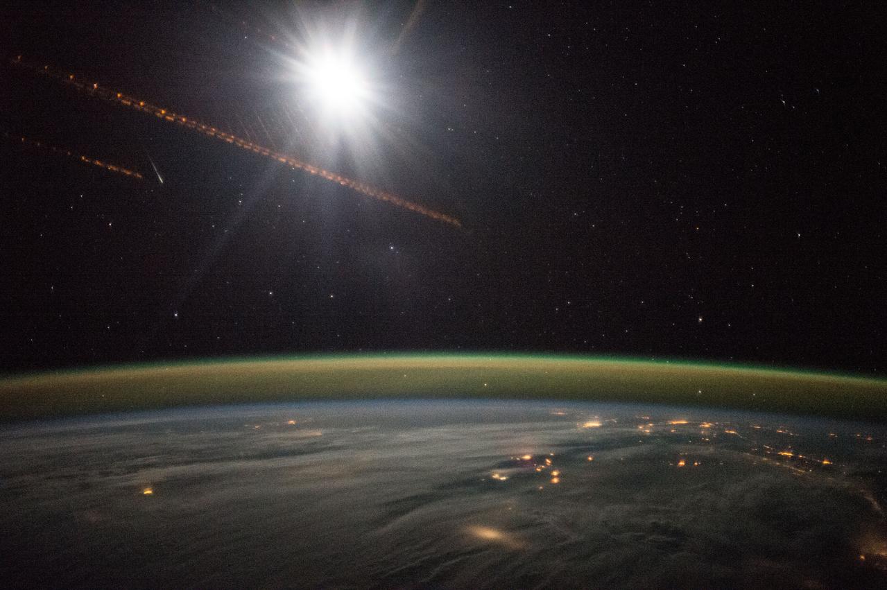
ISS025-E-012937 (7 Nov. 2010) --- Aurora Borealis sits on the horizon of this night view over much of Europe. The Strait of Dover is relatively clear as is Paris, the City of Lights. There is some fog over the western part of England and London.
STS 51-F crewmembers depart the Kennedy Space Center's operations and checkout building on their way to the launch pad for the launch of the Discovery. Leading the way are Gordon Fullerton, commander; Loren Acton, payload specialist, and Anthony England, mission specialist. The other crewmembers are not visible in this frame.
ISS042E037847 (12/15/2014) ---ESA (European Space Agency) astronaut Samantha Cristoforetti captured this image while on the International Space Station. It shows cloud cover over England, Baltic Sea and the Persian Gulf. It also displays a golden aurora with a splash of red through the stars during the night of Dec. 15, 2014.
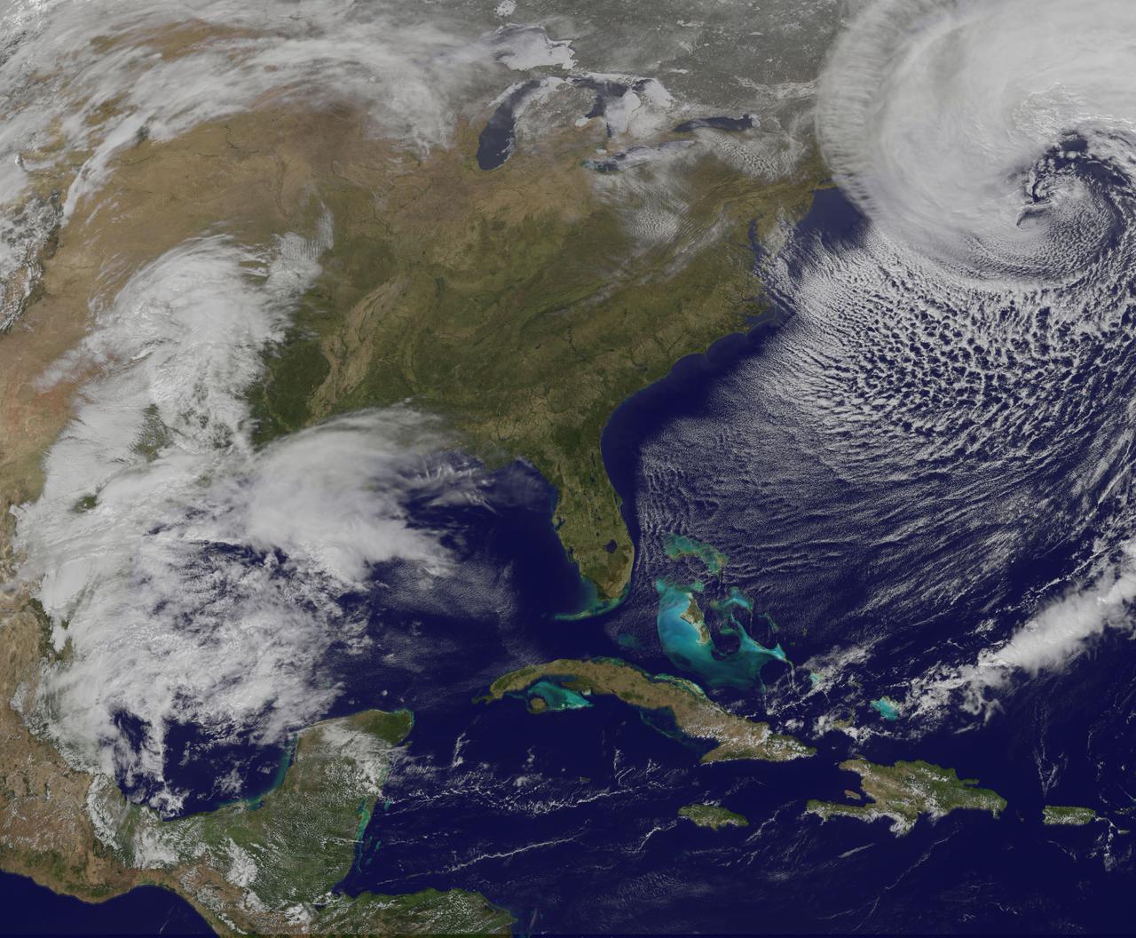
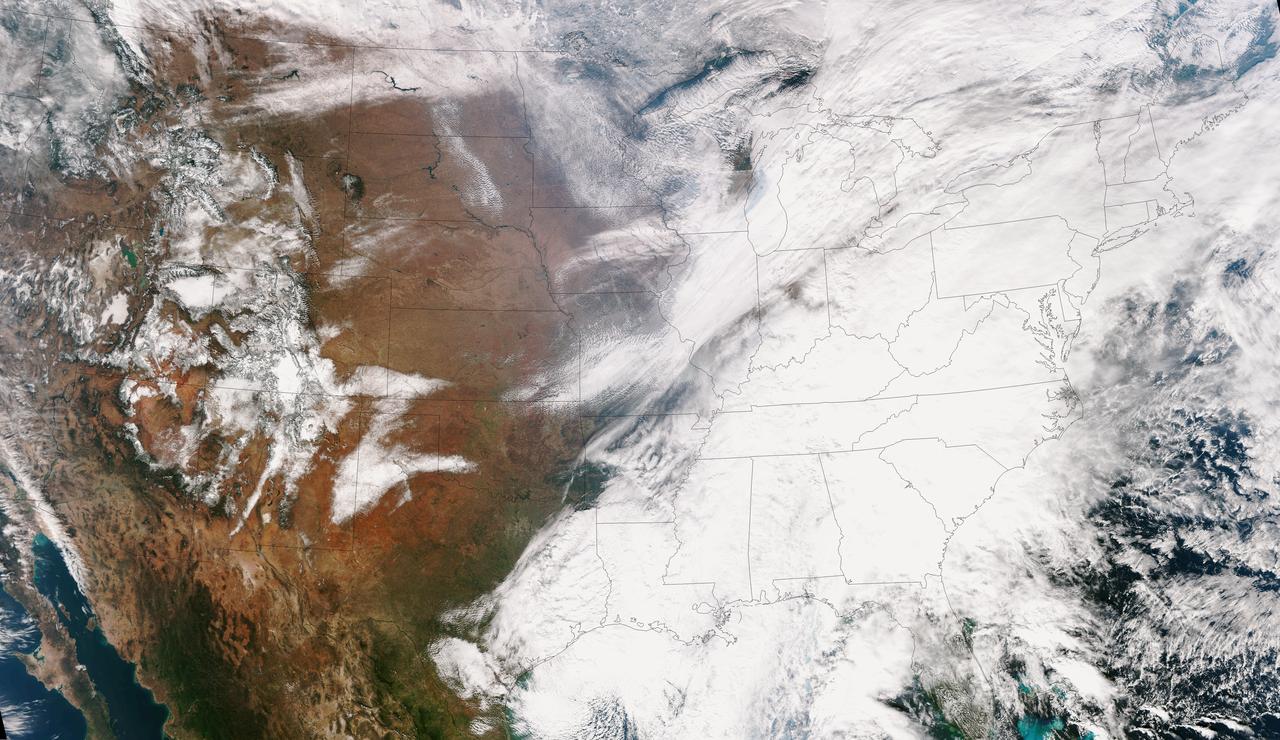
NASA and NOAA satellites are providing various views of the major winter storm marching toward the U.S. East coast on March 13. The storm is forecast to merge with another system and is expected to bring large snowfall totals from the Mid-Atlantic to New England. NASA's Aqua satellite gathered infrared data from the storm system and the area ahead of the storm for cloud and ground temperatures. NOAA's GOES-East satellite provided visible and infrared imagery that showed the extent and the movement of the system. Forecasters at the National Weather Service's Weather Prediction Center (WPC) noted that the low pressure system crossing the Midwest states and Ohio Valley is expected to merge with another low off the southeast U.S. coast. WPC stated "This will allow for a strong nor'easter to develop near the coast and cause a late-season snowstorm from the central Appalachians to New England, including many of the big cities in the Northeast U.S." Credits: NASA/NOAA GOES Project

Sebastian Mathea of the University of Oxford in England, speaks to members of social media in the Kennedy Space Center’s Press Site auditorium. Mathea is principal investigator for the Crystallization of LRRK2 Under Microgravity Conditions experiment. The briefing focused on research planned for launch to the International Space Station. The scientific materials and supplies will be aboard a Dragon spacecraft scheduled for launch from Kennedy’s Launch Complex 39A on Aug. 14 atop a SpaceX Falcon 9 rocket on the company's 12th Commercial Resupply Services mission to the space station.
S71-36874 (10 June 1971) --- University of Texas geologist/professor William R. Muelhberger (left) talks with astronaut John W. Young, Apollo 16 commander, during an Apollo 16 geology field trip to Mono Crater, Calif. Astronaut Charles Duke, lunar module pilot, is seen at frame center, talking to geologist David Wones (second left). Astronaut Anthony England, Apollo 16 spacecraft communicator (CAPCOM), is at right. Photo credit: NASA
61A-52-049 (30 Oct-6 Nov 1985) --- A 70mm image of the Strait of Dover area showing southeast England as photographed from the Earth-orbiting Space Shuttle Challenger by the astronaut crew members of the STS-61A mission. Center point coordinates in the handheld Hasselblad scene are 45.5 degrees north latitude and 0.5 degrees east longitude. Five NASA astronauts were joined by three European scientists for the week-long space flight, marking the largest roster on any Shuttle mission to date.

jsc2017e009671 (01/26/2017) --- Former NFL player Emanuel McNeil (New England Patriots and New York Jets) provides a photo opportunity for a Johnson Space Center(JSC) Staff Member in front of the NASA Mars Rover image. Emanuel is touring JSC as part of the Super Bowl tailgate event. The JSC Center Director invited former NFL players during the week leading up to the Super Bowl. NASA Photographer Lauren Harnett.
SL3-121-2445 (July-September 1973) --- An oblique view of a portion of Great Britain looking northeastward across England and Wales, as photographed by one of the Skylab 3 crewmen aboard the Skylab space station in Earth orbit. The picture was taken with a hand-held 70mm Hasselblad camera using a 100mm lens and SO-368 medium-speed Ektacrome film. The English Channel is at lower right. The Bristol Channel is at lower left. The North Sea with much cloud cover is in the background. Photo credit: NASA

jsc2017e009678 (01/26/2017) --- Former NFL player Mickey Washington (New England Patriots, Washington Redskins, Buffalo Bills, Jacksonville Jaguars, and New Orleans Saints) provides a picture opportunity for a Johnson Space Center staff member during the JSC Super Bowl Tailgate event. Many former NFL players attended the event that included a tour of Mission Control and other JSC areas. NASA Photographer Lauren Harnett.
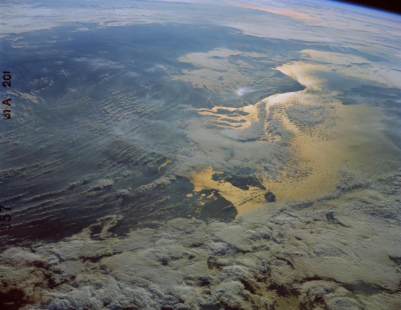
61A-201-057 (30 Oct-6 Nov 1985) --- The North Sea, looking southwest toward Brittany, visible in the upper right portion of the frame. The islands of the mouths of the Rhine River are in the foreground, and above them sunlight reflects off the long causeways and dikes of the Ijsselmeer in the Netherlands. To the right is the Strait of Dover (Pas de Calais) with the southeast corner of England just above the right center edge.
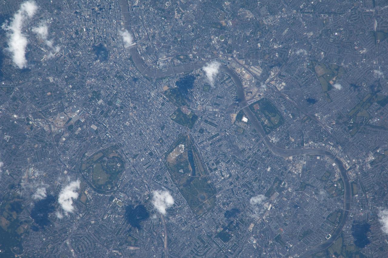
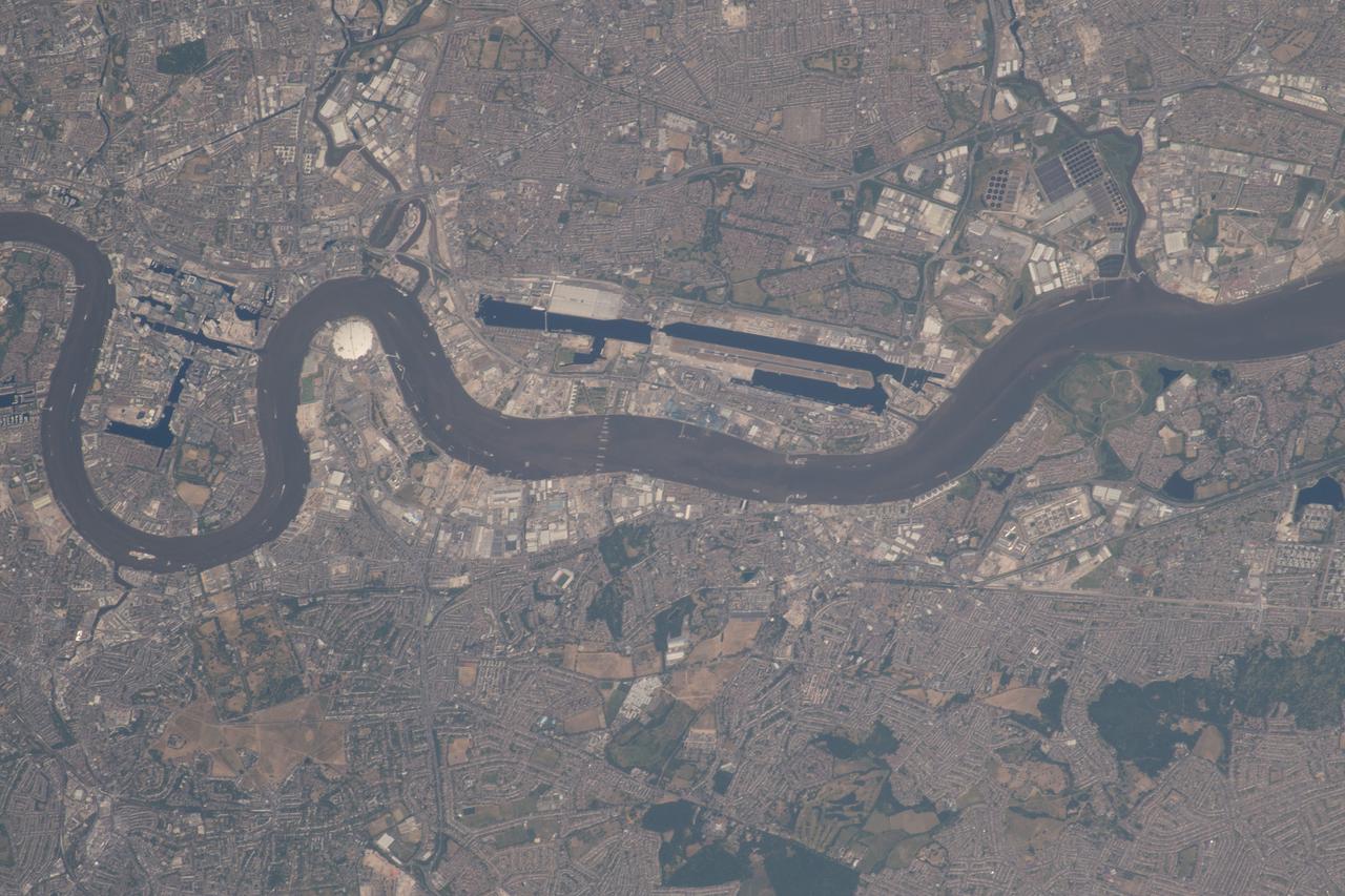
ISS040-E-033077 (4 July 2014) --- Because the Expedition 40 crew member on the International Space Station, flying at an altitude of 221 nautical miles, was using an 800mm focal length on his camera, great detail can be seen in this picture featuring a large portion of London, England. The Thames River is easily spotted snaking through the large city.

STS073-725-031 (24 October 1995) --- The contrasting colors of fall in New England are captured on this northward-looking photo of Martha's Vineyard, Nantucket Island, and the famous hook-shaped Cape Cod. Light-colored patches of urbanization are scattered throughout the scene, the most evident being the greater Boston area along the shores of Massachusetts Bay. The cape is composed of rock debris that, according to NASA scientists studying Columbia's photo collection, was deposited along the end of glacier some 20,000 years ago.
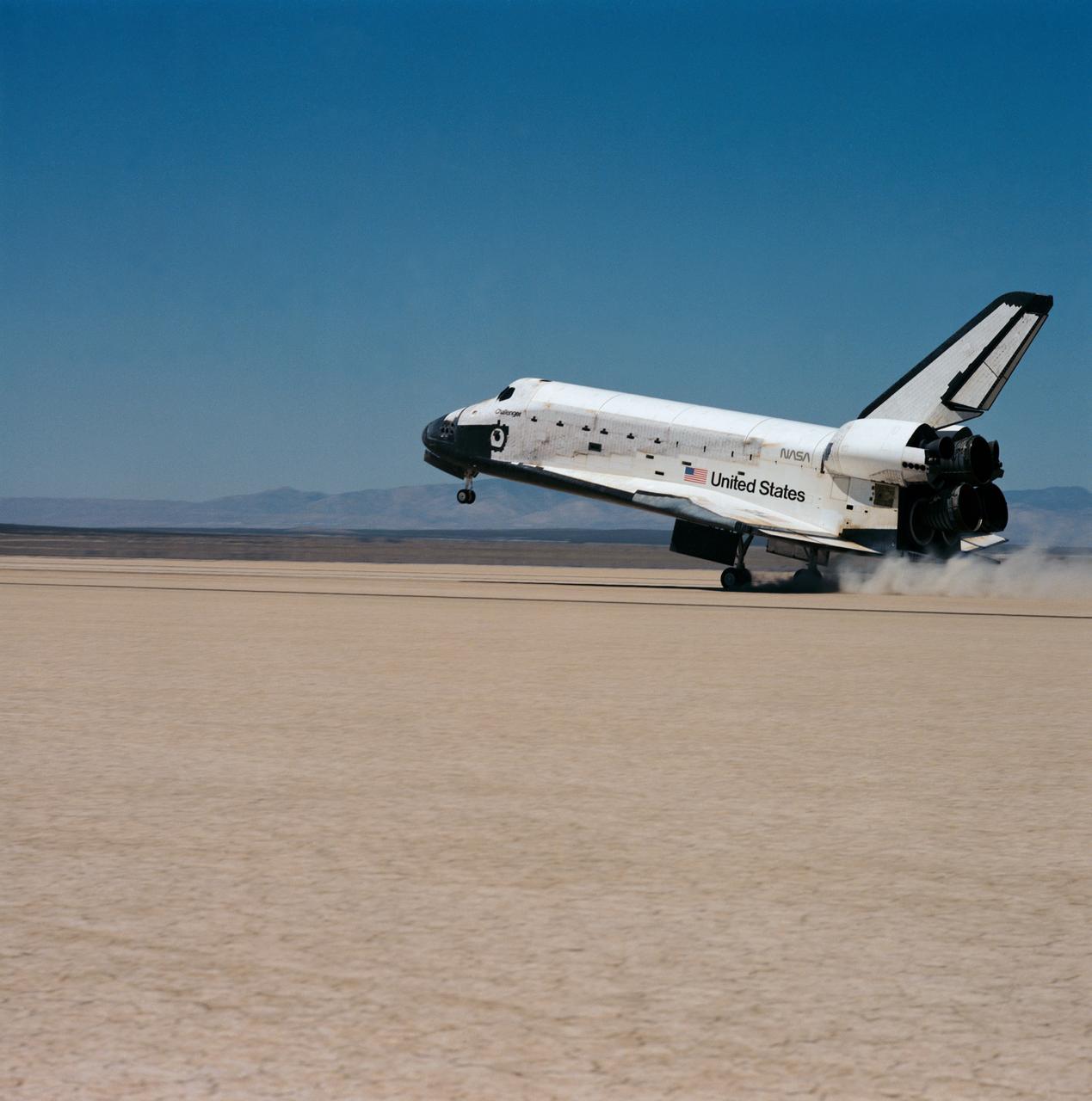
51F-S-161 (6 Aug 1985) --- The Space Shuttle Challenger, with its seven member crew and battery of scientific experiments aboard, eases its rear landing gear onto the dry lake bed at Edwards Air Force Base in California. Onboard for the eight-day mission were C. Gordon Fullerton, Roy D. Bridges Jr., F. Story Musgrave, Karl J. Henize, Anthony W. England, Loren W. Acton and John-David Bartoe.
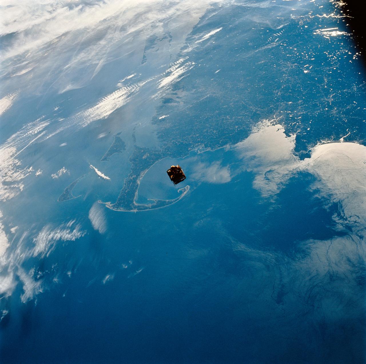
STS064-111-041 (12 Sept. 1994) ---- Backdropped against New England's coast, the Shuttle Pointed Autonomous Research Tool for Astronomy (SPARTAN-201) satellite begins its separation from the space shuttle Discovery. The free-flying spacecraft, 130 nautical miles above Cape Cod at frame center, remained some 40 miles away from Discovery until the crew retrieved it two days later. Photo credit: NASA or National Aeronautics and Space Administration
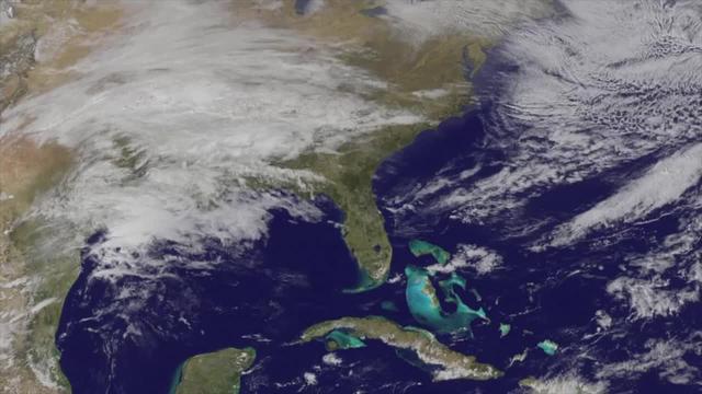
This true color image of the Continental United States was taken on Nov. 25, 2013 by the Suomi NPP satellite and shows the system as it moves through the South and Midwest. The National Weather Service noted that a complex and powerful storm system continues to generate widespread moderate to heavy rainfall and snows in various parts of the eastern United States as travelers make their way to destinations to celebrate Thanksgiving and Hanukkah on Nov. 28. There are two low-pressure areas working together. One was centered near New Jersey while the other was located over the Carolinas. From the Southeast to New England widespread moderate to heavy rainfall is expected. The rains will also affect the Mid-Atlantic and Southeastern United States, although those regions are not expected to get as much of a soaking. The Appalachians and interior New England are expected to receive snowfall. Areas of heavy snow are forecast for northwestern Indiana and northwestern Pennsylvania on Nov. 27. Snows will blanket the north central United States from the Dakotas to Minnesota, Iowa, Wisconsin, Michigan, the Ohio and Tennessee Valleys, upstate New York and parts of northern New England. The National Weather Service noted that cold air is moving in behind the storm and drop temperatures along the eastern U.S. making for a chilly Thanksgiving. Credit: NASA/NOAA <b><a href="http://www.nasa.gov/audience/formedia/features/MP_Photo_Guidelines.html" rel="nofollow">NASA image use policy.</a></b> <b><a href="http://www.nasa.gov/centers/goddard/home/index.html" rel="nofollow">NASA Goddard Space Flight Center</a></b> enables NASA’s mission through four scientific endeavors: Earth Science, Heliophysics, Solar System Exploration, and Astrophysics. Goddard plays a leading role in NASA’s accomplishments by contributing compelling scientific knowledge to advance the Agency’s mission. <b>Follow us on <a href="http://twitter.com/NASA_GoddardPix" rel="nofollow">Twitter</a></b> <b>Like us on <a href="http://www.facebook.com/pages/Greenbelt-MD/NASA-Goddard/395013845897?ref=tsd" rel="nofollow">Facebook</a></b> <b>Find us on <a href="http://instagram.com/nasagoddard?vm=grid" rel="nofollow">Instagram</a></b>
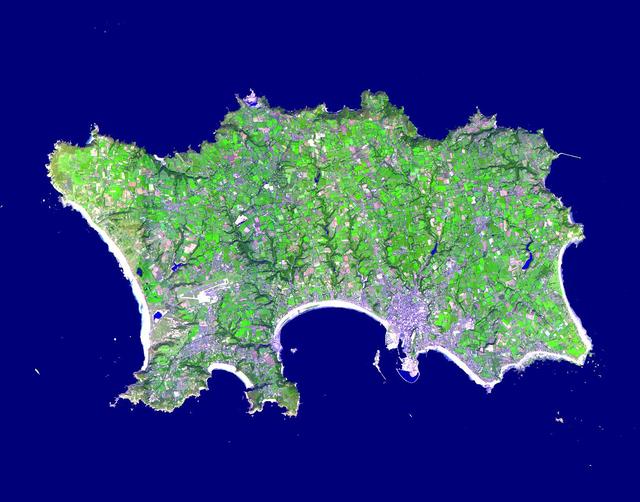
The Isle of Jersey (officially called the Bailiwick of Jersey) is the largest Channel Island, positioned in the Bay of Mont St Michel off the north-west coast of France. The island has a population of about 90,000, and covers about 90 square kilometers. The economy is based largely on international financial services, agriculture, and tourism. Called Caesaria in Roman times, Jersey becaame part of the Duchy of Normandy in 912. When William the Conqueror invaded and took the throne of England in 1066, the fortunes of Jersey then became linked to those in England, although the island manages its internal affairs through its own parliament, the States of Jersey. This image was acquired on September 23, 2000 by the Advanced Spaceborne Thermal Emission and Reflection Radiometer (ASTER) on NASA's Terra satellite. With its 14 spectral bands from the visible to the thermal infrared wavelength region, and its high spatial resolution of 15 to 90 meters (about 50 to 300 feet), ASTER images Earth to map and monitor the changing surface of our planet. http://photojournal.jpl.nasa.gov/catalog/PIA03879
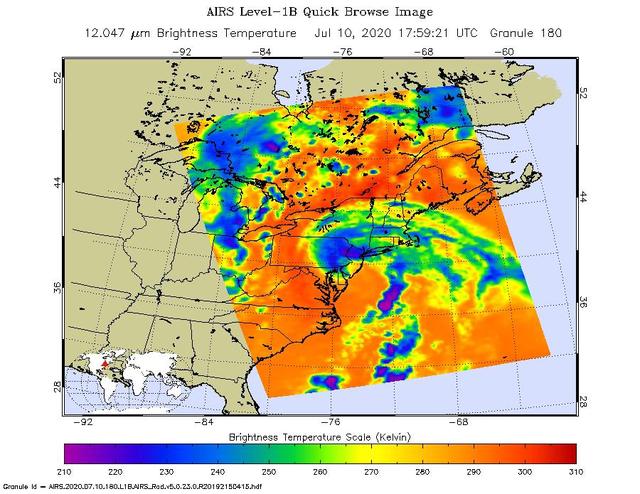
NASA's Atmospheric Infrared Sounder (AIRS) collected this image of Tropical Storm Fay over New England at around 2 p.m. local time on Friday, July 10. The center of the storm made landfall about 10 miles (15 kilometers) north-northeast of Atlantic City, New Jersey, at around 5 p.m. local time, when Fay had maximum sustained winds of around 50 mph (85 kph). In the infrared AIRS image, the purple regions indicate very cold clouds lofted high into the atmosphere by the storm. These clouds are generally linked to heavy rainfall. Warmer clouds closer to the ground show up as green and blue, while the orange areas denote mostly cloud-free parts of the sky. AIRS, together with the Advanced Microwave Sounding Unit (AMSU), measures the infrared and microwave radiation emitted from Earth to study the planet's weather and climate. Both instruments observe Earth from NASA's Aqua satellite, which launched in 2002. AIRS and AMSU work in tandem to make simultaneous observations down to Earth's surface, even in the presence of heavy clouds. With more than 2,000 channels sensing different regions of the atmosphere, the system creates a global, three-dimensional map of atmospheric temperature and humidity, cloud amounts and heights, greenhouse gas concentrations, and many other atmospheric phenomena. https://photojournal.jpl.nasa.gov/catalog/PIA23783
41G-121-139 (5-13 Oct. 1984) --- The Strait of Dover and London, seldom seen in space photography, can be delineated in this medium format camera's scene showing parts of England and France from onboard the Earth-orbiting space shuttle Challenger. Parts of the Thames River can also be traced in the frame. The 41-G crew consisted of astronauts Robert L. Crippen, commander; Jon A. McBride, pilot; and Mission Specialists Kathryn D. Sullivan, Sally K. Ride, and David D. Leestma; along with Canadian astronaut Marc Garneau; and Paul D. Scully-Power, both payload specialists. Photo credit: NASA
ISS034-E-039331 (2 Feb. 2013) --- This nocturnal photo of London, England was downlinked by the Expedition 34 crew from the International Space Station, flying approximately 240 miles above Earth, on Feb. 2, 2013. Expedition 34 Flight Engineer Chris Hadfield, astronaut with the Canadian Space Agency, added this footnote to his downlink: ?London, on the Thames, from the city to the encircling motorway. Heathrow very visible on the (west).? North is at the bottom making west on the right in this image. It?s the bright feature with dark parallel lines near the outer looping road.

CAPE CANAVERAL, Fla. – At the Aerospace and Defense Manufacturing Center in Cape Canaveral, Fla., Jim England of Craig Technologies Environmental, Health and Safety checks the performance of one of the 1,600 pieces of specialty equipment at the 161,000-square-foot facility. In June of last year, NASA signed a partnership agreement with Craig Technologies to maintain an inventory of unique processing and manufacturing equipment for future mission support at the agency's Kennedy Space Center. The Cape Canaveral, Fla., facility, formerly known as the NASA Shuttle Logistics Depot NSLD, is now the Aerospace and Defense Manufacturing Center ADMC. Photo credit: NASA_Kim Shiflett
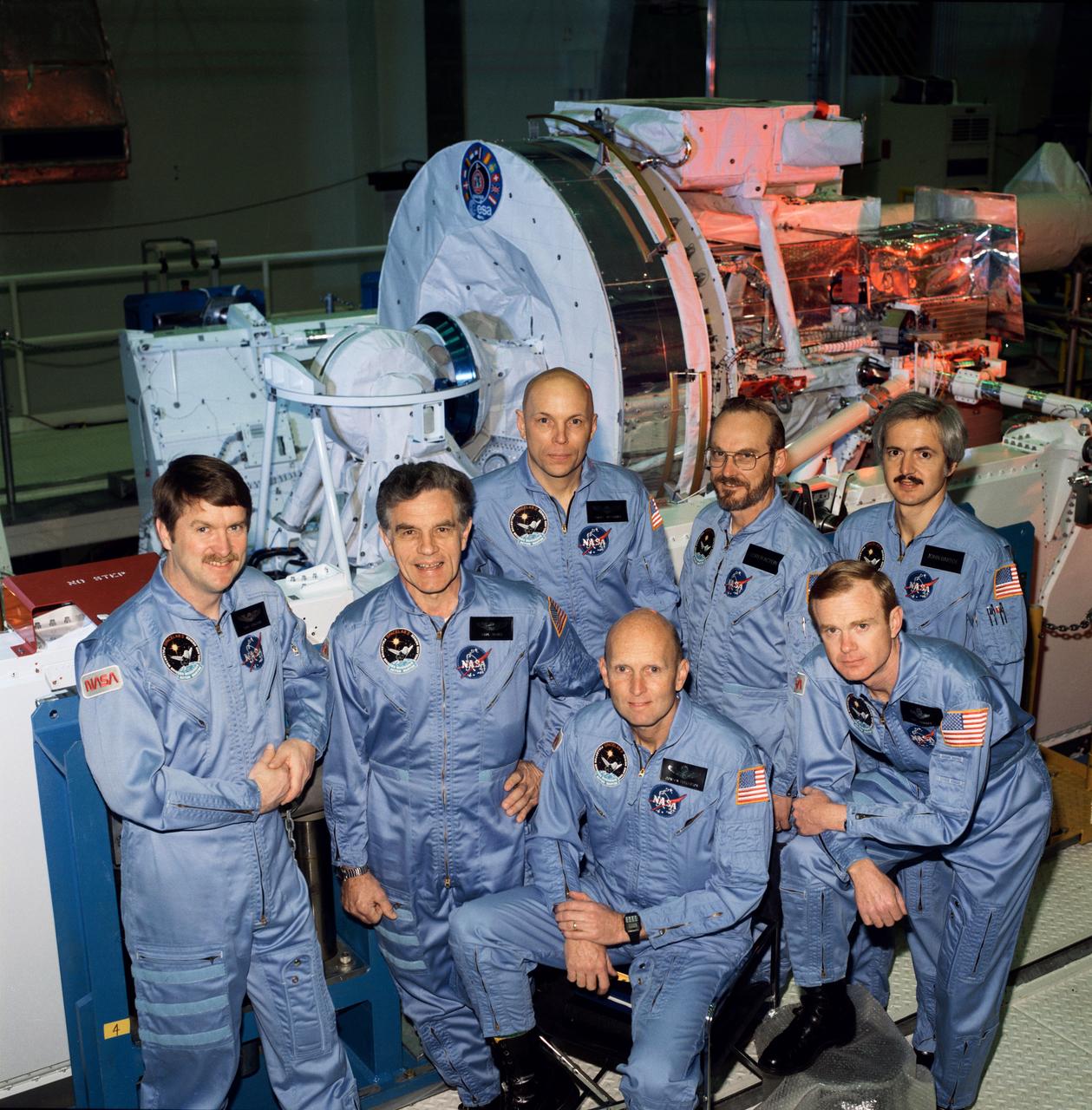
S85-29307 (May 1985) --- The seven crew members for the Space Shuttle STS-51F/Spacelab 2 mission take a pause from a KSC training session to pose for a pre-flight crew portrait. Astronauts C. Gordon Fullerton (kneeling center), mission commander; and Roy D. Bridges (kneeling right), pilot; are flanked by the payload specialists and mission specialists for the mission. Standing (left to right) are astronauts Anthony W. England, Karl J. Henize and Story Musgrave - all mission specialists; and payload specialist Loren Acton and John-David Bartoe.
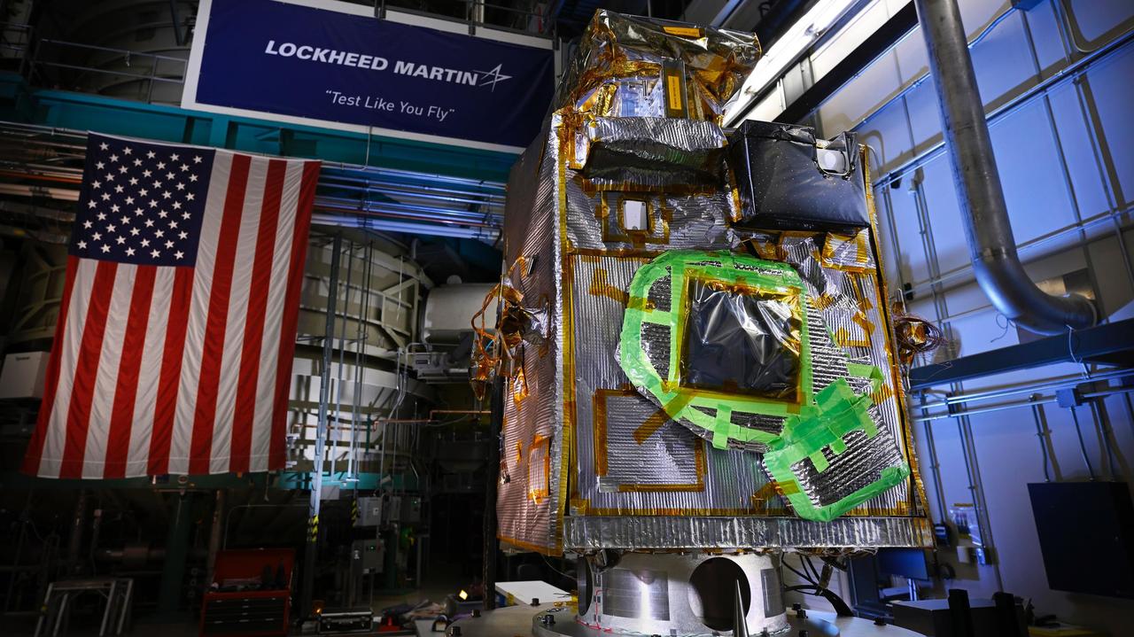
NASA's Lunar Trailblazer sits in a clean room at Lockheed Martin Space in Littleton, Colorado, shortly after being integrated with its second and final science instrument in June 2023. Called the Lunar Thermal Mapper (LTM), the instrument is visible as a black rectangular box in the upper right of the spacecraft's body. Green tape on the spacecraft will be removed before launch. Built by the University of Oxford in England and contributed by the UK Space Agency, LTM joins the High-resolution Volatiles and Minerals Moon Mapper (HVM³) that was integrated with the spacecraft late last year. Together, the instruments will enable scientists to determine the abundance, location, and form of the Moon's water. https://photojournal.jpl.nasa.gov/catalog/PIA25837
S85-36655 (24 June 1985) --- The seven crewmembers for STS 51-F/Spacelab 2 pose for photographers following their pre-flight press conference in the Johnson Space Center's public affairs facility. Standing, l.-r., are Karl J. Henize, mission specialist; Roy D. Bridges, pilot; C. Gordon Fullerton, mission commander; F. Story Musgrave, mission specialist; John-David Bartoe, payload specialist; and Anthony W. England, mission specialist. Loren W. Acton, payload specialist, is seated. Launch is scheduled for July of this year.

Artifacts retrieved from the ruins of Elliot Plantation on NASA’s Kennedy Space Center in Florida include Spanish majolica fragments, likely produced between the 1730s to the 1750s and imported to the plantation from England. Ceramic fragments of majolica, delftware, and other high-status domestic wares were retrieved from ruins determined to be the dwelling of the plantation overseer. The ruins of Elliot Plantation date from the 1760s and represent the largest, earliest, and southernmost British period sugar plantation in the U.S., as well as one of the most intact and best examples of a completely preserved enslaved landscape. In interagency cooperation between the National Park Service, the U.S. Fish and Wildlife Service, and NASA, and with the assistance of volunteers from the Indian River Anthropological Society, and historic preservation offices of Brevard and Volusia counties, approximately 200 shovel tests and 20 excavation units were completed in three areas of the plantation complex from 2008 to 2009.

KENNEDY SPACE CENTER, FLA. -- Cherie Blair (center), wife of Tony Blair, prime minister of Great Britain, is given a guided walkthrough of the Space Station Processing Facility during a tour of Kennedy Space Center. From left in front are Gale Booth (Mrs. Blair's mother), Mrs. Blair and Tom Pentrack, deputy director of ISS and Spacecraft Processing. Mrs. Blair is an attorney (barrister) in England. She was Chancellor of Liverpool John Moores University from 1999-2006, and in July 2006 was awarded the honorary title of Emeritus Chancellor. She is also Governor of the London School of Economics and the Open University. She is a founding member of Matrix Chambers in London, from which she continues to practice as a barrister, which specializes in human rights law. Photo credit: NASA/John Keckley
STS102-336-035 (8-21 March 2001) --- One of the STS-102 astronauts aimed a 35mm camera through windows on the aft flight deck of the Space Shuttle Discovery to capture this synoptic southeast view of several New England states. The moderating influence of the Atlantic Ocean is visible along the coastline. The southern limit of the snow-covered landscape can be traced from southeast Massachusetts (left center) westward along the northern shore of Long Island Sound and includes the northern end of New Jersey (right center). In addition to Long Island (center), other prominent features on this image include: Cape Cod, Martha's Vineyard, Nantucket, and Block Islands; as well as the Hudson River (bottom center). Several southerly-draining river systems are discernible in Connecticut and extensive wetlands are observed along New York and New Jersey coastal areas.
KENNEDY SPACE CENTER, FLA. -- Cherie Blair, wife of Tony Blair, prime minister of Great Britain, stops at Launch Pad 39B on a tour of Kennedy Space Center. At left is the KSC bus driver, Dale Meneau, and at right is Robert Dudiak, a personal friend of the Blairs. Mrs. Blair is an attorney (barrister) in England. She was Chancellor of Liverpool John Moores University from 1999-2006, and in July 2006 was awarded the honorary title of Emeritus Chancellor. She is also Governor of the London School of Economics and the Open University. She is a founding member of Matrix Chambers in London, from which she continues to practice as a barrister, which specializes in human rights law. Photo credit: NASA/John Keckley
STS026-038-056 (29 Sept. - 3 Oct. 1988) --- Tambora Caldera, Sumbawa Island, Indonesia as photographed with a 70mm handheld Hasselblad camera. Tambora is a 6-kilometer-wide and 650-meter-deep Caldera formed in 1815 as a result of a huge volcanic eruption. Gases from the eruption were ejected high into Earth's atmosphere and transported around the globe. The atmospheric gases trapped part of the incoming sunglint, resulting in extremely cold weather. In New England, snow fell in June, and freezes occurred throughout the summer of 1816, which became known as "the year without a summer." This photo was shown by the STS-26 astronaut crew during its Oct. 11, l988 post-flight press conference.
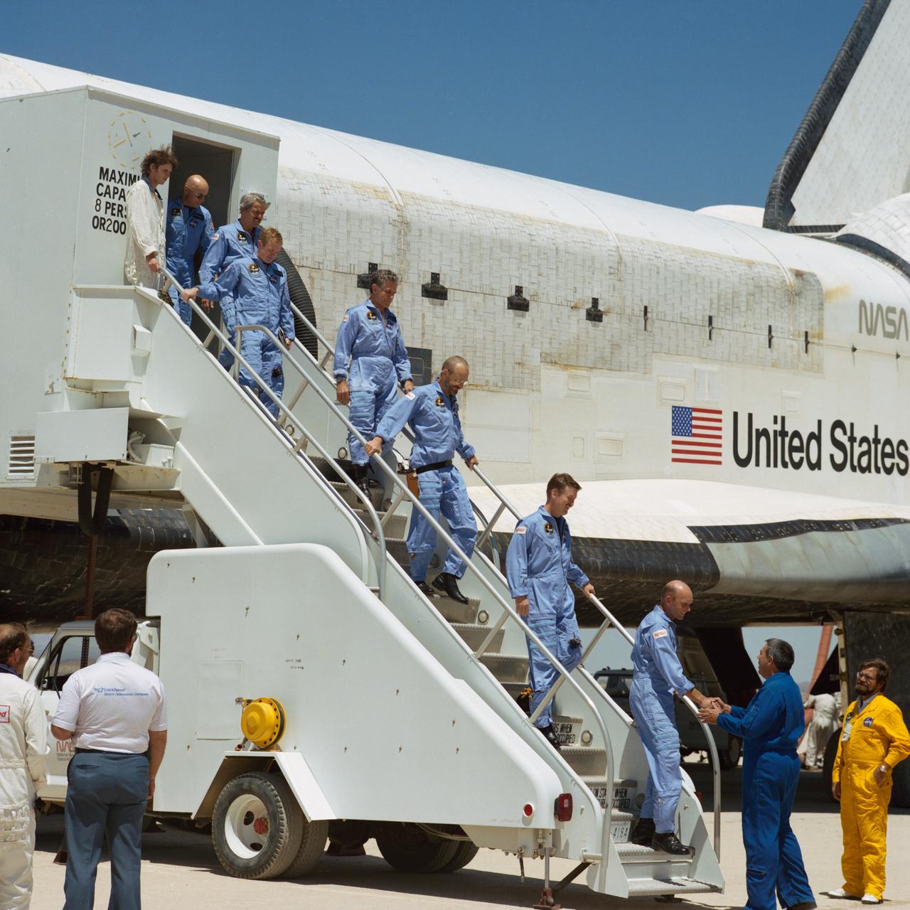
51F-S-162 (6 Aug 1985) ---Mission Operations Director George W.S. Abbey, right, shakes hands with Astronaut C. Gordon Fullerton, as the seven-member 51F crew descends from its "home" for eight days. Other Challenger crewmembers egressing the spacecraft are, left to right, F. Story Musgrave, mission specialist; John-David Bartoe, payload specialist; Roy D. Bridges, Jr., Karl J. Henize, mission specialist; Loren W. Acton, payload specialist; and Anthony W. England, mission specicalist. Fullerton, commander, earlier successfully landed Challenger on a Mojave desert dry lake bed. Three years ago, Fullerton was pilot of STS-3, on which the Columbia's scheduled Edwards landing was moved to New Mexico because of weather and runway conditions here.
The storm system that moved through the northeastern U.S. dropped large snowfall totals up to a foot in southern New England to a couple of inches in Virginia. On January 22, 2014, the day after the event, the Moderate Resolution Imaging Spectroradiometer instrument that flies aboard NASA's Aqua satellite captured this image of the snowfall at 18:10 UTC/1:10 p.m. EST. In the image, snowfall covers the ground in all six New England states, New York, Pennsylvania, New Jersey, Delaware, Maryland, West Virginia, Ohio, Virginia, Washington, D.C. and North Carolina. Image Credit: NASA Goddard MODIS Rapid Response Team Text: Rob Gutro, NASA Goddard Space Flight Center <b><a href="http://www.nasa.gov/audience/formedia/features/MP_Photo_Guidelines.html" rel="nofollow">NASA image use policy.</a></b> <b><a href="http://www.nasa.gov/centers/goddard/home/index.html" rel="nofollow">NASA Goddard Space Flight Center</a></b> enables NASA’s mission through four scientific endeavors: Earth Science, Heliophysics, Solar System Exploration, and Astrophysics. Goddard plays a leading role in NASA’s accomplishments by contributing compelling scientific knowledge to advance the Agency’s mission. <b>Follow us on <a href="http://twitter.com/NASAGoddardPix" rel="nofollow">Twitter</a></b> <b>Like us on <a href="http://www.facebook.com/pages/Greenbelt-MD/NASA-Goddard/395013845897?ref=tsd" rel="nofollow">Facebook</a></b> <b>Find us on <a href="http://instagram.com/nasagoddard?vm=grid" rel="nofollow">Instagram</a></b>
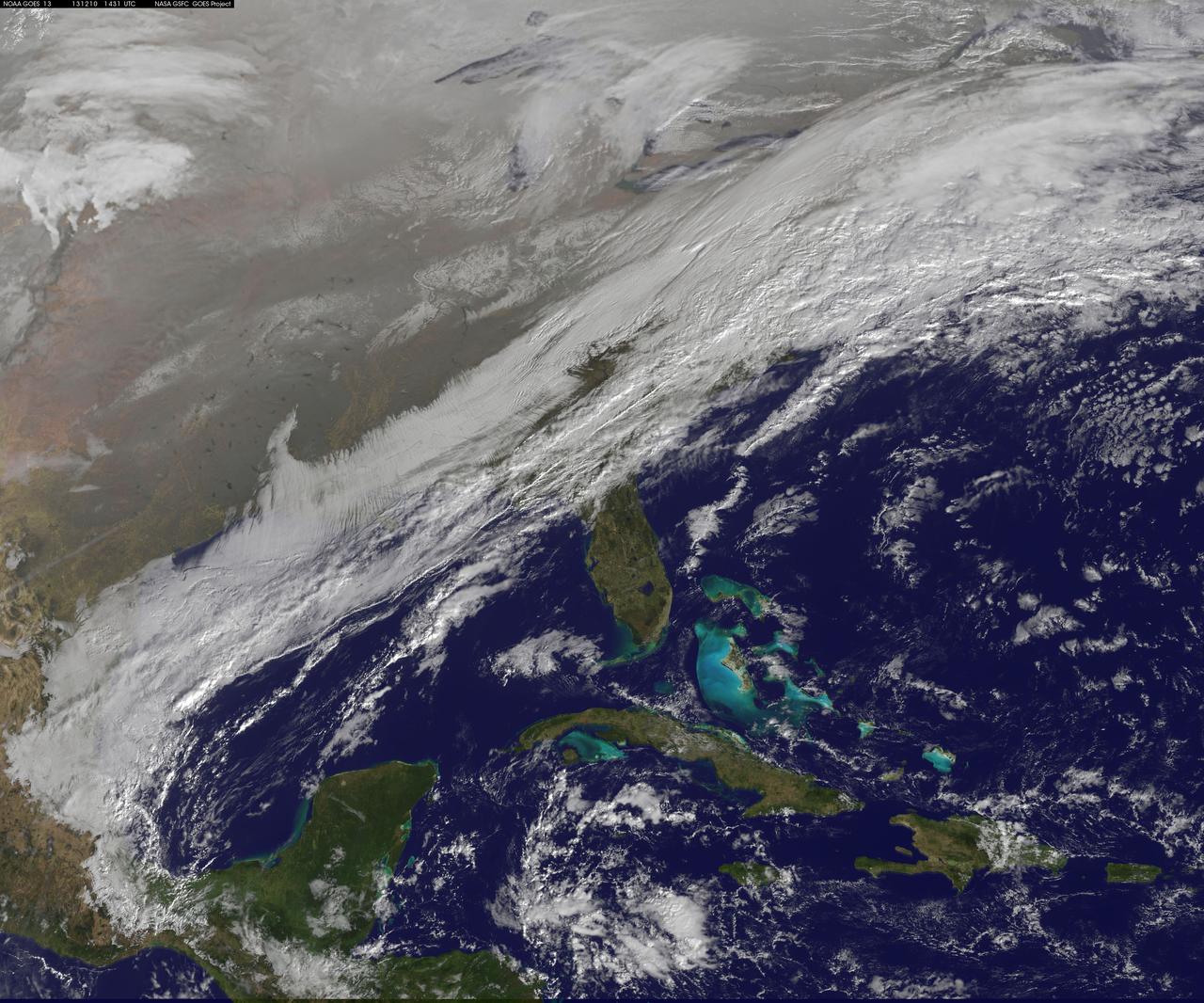
This image shows the strom system on Dec. 10, 2013 at 1445 UTC. According to the National Weather Service snow is falling from Tennessee Valley into the Mid-Atlantic and New England Tuesday . The fast moving system is creating swath of 2 to 7 inches of snow from southwest Virginia to the New England coast. Heavy Lake Effect snows will also impact the Lower Great Lakes into later this week, with up to two feet of accumulation. <b><a href="http://goes.gsfc.nasa.gov/" rel="nofollow">Credit: NOAA/NASA GOES Project</a></b> <b><a href="http://www.nasa.gov/audience/formedia/features/MP_Photo_Guidelines.html" rel="nofollow">NASA image use policy.</a></b> <b><a href="http://www.nasa.gov/centers/goddard/home/index.html" rel="nofollow">NASA Goddard Space Flight Center</a></b> enables NASA’s mission through four scientific endeavors: Earth Science, Heliophysics, Solar System Exploration, and Astrophysics. Goddard plays a leading role in NASA’s accomplishments by contributing compelling scientific knowledge to advance the Agency’s mission. <b>Follow us on <a href="http://twitter.com/NASA_GoddardPix" rel="nofollow">Twitter</a></b> <b>Like us on <a href="http://www.facebook.com/pages/Greenbelt-MD/NASA-Goddard/395013845897?ref=tsd" rel="nofollow">Facebook</a></b> <b>Find us on <a href="http://instagrid.me/nasagoddard/?vm=grid" rel="nofollow">Instagram</a></b>
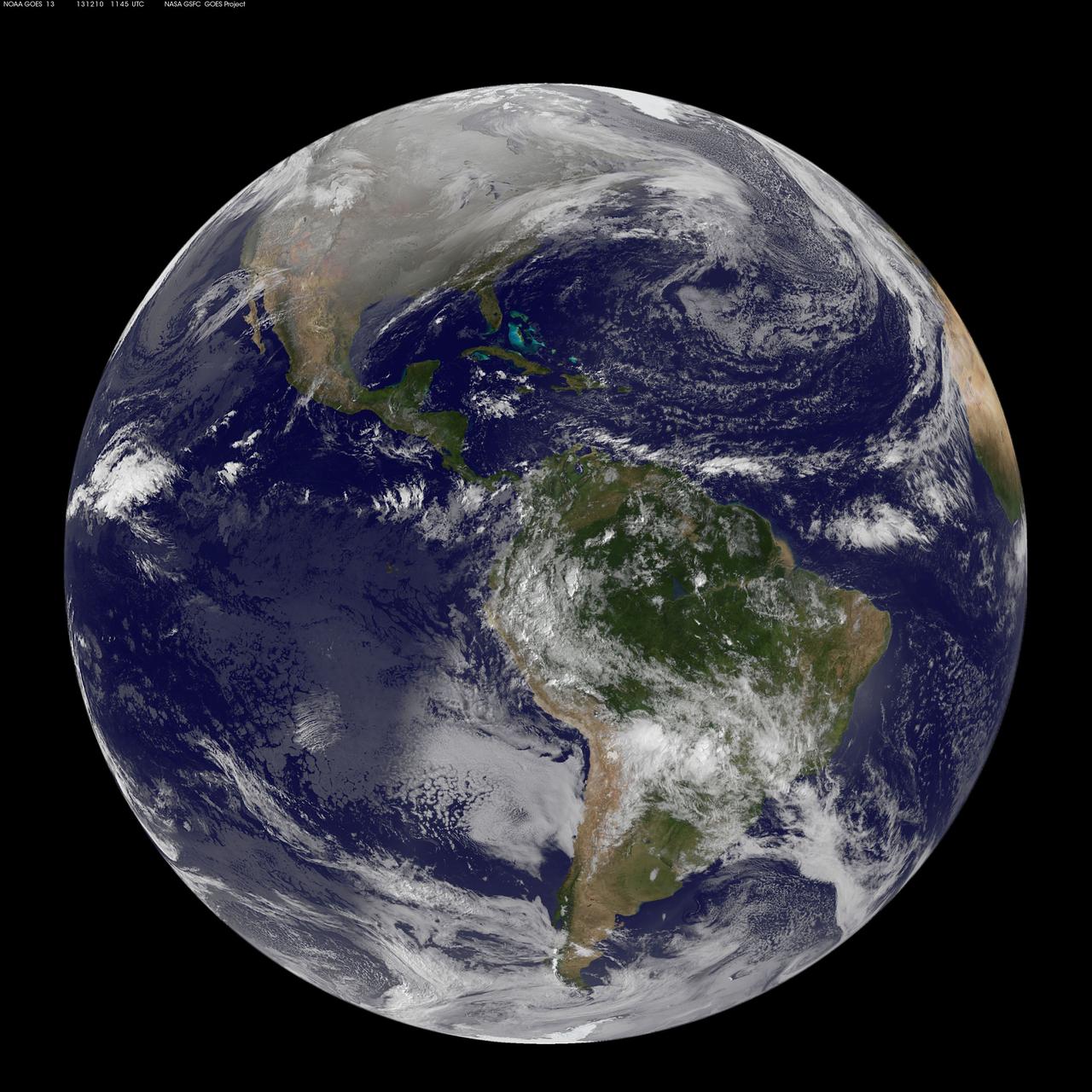
This full disc image of earth shows the strom system on Dec. 10, 2013 at 1445 UTC. According to the National Weather Service snow is falling from Tennessee Valley into the Mid-Atlantic and New England Tuesday . The fast moving system is creating swath of 2 to 7 inches of snow from southwest Virginia to the New England coast. Heavy Lake Effect snows will also impact the Lower Great Lakes into later this week, with up to two feet of accumulation. <b><a href="http://goes.gsfc.nasa.gov/" rel="nofollow">Credit: NOAA/NASA GOES Project</a></b> <b><a href="http://www.nasa.gov/audience/formedia/features/MP_Photo_Guidelines.html" rel="nofollow">NASA image use policy.</a></b> <b><a href="http://www.nasa.gov/centers/goddard/home/index.html" rel="nofollow">NASA Goddard Space Flight Center</a></b> enables NASA’s mission through four scientific endeavors: Earth Science, Heliophysics, Solar System Exploration, and Astrophysics. Goddard plays a leading role in NASA’s accomplishments by contributing compelling scientific knowledge to advance the Agency’s mission. <b>Follow us on <a href="http://twitter.com/NASA_GoddardPix" rel="nofollow">Twitter</a></b> <b>Like us on <a href="http://www.facebook.com/pages/Greenbelt-MD/NASA-Goddard/395013845897?ref=tsd" rel="nofollow">Facebook</a></b> <b>Find us on <a href="http://instagrid.me/nasagoddard/?vm=grid" rel="nofollow">Instagram</a></b>
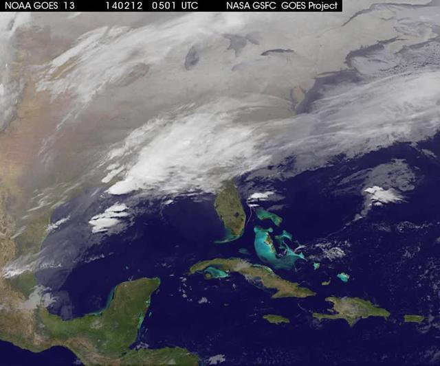
A new NASA video of NOAA's GOES satellite imagery shows three days of movement of the massive winter storm that stretches from the southern U.S. to the northeast. Visible and infrared imagery from NOAA's GOES-East or GOES-13 satellite from Feb. 10 at 1815 UTC/1:15 p.m. EST to Feb. 12 to 1845 UTC/1:45 p.m. EST were compiled into a video made by NASA/NOAA's GOES Project at NASA's Goddard Space Flight Center in Greenbelt, Md. In the video, viewers can see the development and movement of the clouds associated with the progression of the frontal system and related low pressure areas that make up the massive storm. The video also shows the snow covered ground over the Great Lakes region and Ohio Valley that stretches to northern New England. The clouds and fallen snow data from NOAA's GOES-East satellite were overlaid on a true-color image of land and ocean created by data from the Moderate Resolution Imaging Spectroradiometer or MODIS instrument that flies aboard NASA's Aqua and Terra satellites. On February 12 at 10 a.m. EST, NOAA's National Weather Service or NWS continued to issue watches and warnings from Texas to New England. Specifically, NWS cited Winter Storm Warnings and Winter Weather Advisories were in effect from eastern Texas eastward across the interior section of southeastern U.S. states and across much of the eastern seaboard including the Appalachians. Winter storm watches are in effect for portions of northern New England as well as along the western slopes of northern and central Appalachians. For updates on local forecasts, watches and warnings, visit NOAA's <a href="http://www.weather.gov" rel="nofollow">www.weather.gov</a> webpage. NOAA's Weather Prediction Center or WPC noted the storm is expected to bring "freezing rain spreading into the Carolinas, significant snow accumulations are expected in the interior Mid-Atlantic states tonight into Thursday and ice storm warnings and freezing rain advisories are in effect across much of central Georgia. GOES satellites provide the kind of continuous monitoring necessary for intensive data analysis. Geostationary describes an orbit in which a satellite is always in the same position with respect to the rotating Earth. This allows GOES to hover continuously over one position on Earth's surface, appearing stationary. As a result, GOES provide a constant vigil for the atmospheric "triggers" for severe weather conditions such as tornadoes, flash floods, hail storms and hurricanes. For updated information about the storm system, visit NOAA's WPC website; <a href="http://www.hpc.ncep.noaa.gov/" rel="nofollow">www.hpc.ncep.noaa.gov/</a> For more information about GOES satellites, visit: <a href="http://www.goes.noaa.gov/" rel="nofollow">www.goes.noaa.gov/</a> or <a href="http://goes.gsfc.nasa.gov/" rel="nofollow">goes.gsfc.nasa.gov/</a> Rob Gutro NASA's Goddard Space Flight Center <b><a href="http://goes.gsfc.nasa.gov/" rel="nofollow">Credit: NOAA/NASA GOES Project</a></b> <b><a href="http://www.nasa.gov/audience/formedia/features/MP_Photo_Guidelines.html" rel="nofollow">NASA image use policy.</a></b> <b><a href="http://www.nasa.gov/centers/goddard/home/index.html" rel="nofollow">NASA Goddard Space Flight Center</a></b> enables NASA’s mission through four scientific endeavors: Earth Science, Heliophysics, Solar System Exploration, and Astrophysics. Goddard plays a leading role in NASA’s accomplishments by contributing compelling scientific knowledge to advance the Agency’s mission. <b>Follow us on <a href="http://twitter.com/NASAGoddardPix" rel="nofollow">Twitter</a></b> <b>Like us on <a href="http://www.facebook.com/pages/Greenbelt-MD/NASA-Goddard/395013845897?ref=tsd" rel="nofollow">Facebook</a></b> <b>Find us on <a href="http://instagrid.me/nasagoddard/?vm=grid" rel="nofollow">Instagram</a></b>

NOAA's GOES-East satellite provided a look at the frigid eastern two-thirds of the U.S. on Jan. 7, 2015, that shows a blanket of northern snow, lake-effect snow from the Great Lakes and clouds behind the Arctic cold front. A visible picture captured at 1600 UTC (11 a.m. EST) showed the effects of the latest Arctic outbreak. The cold front that brought the Arctic air has moved as far south as Florida, and stretches back over the Gulf of Mexico and just west of Texas today. The image shows clouds behind the frontal boundary stretching from the Carolinas west over the Heartland. Farther north, a wide band of fallen snow covers the ground from New England west to Montana, with rivers appearing like veins. The GOES-East satellite image also shows wind-whipped lake-effect snows off the Great Lakes, blowing to the southeast. Meanwhile, Florida, the nation's warm spot appeared almost cloud-free. To create the image, NASA/NOAA's GOES Project used cloud data from NOAA's GOES-East satellite and overlaid it on a true-color image of land and ocean created by data from the Moderate Resolution Imaging Spectroradiometer, or MODIS, instrument that flies aboard NASA's Aqua and Terra satellites. Together, those data created the entire picture of the Arctic outbreak. The forecast from NOAA's National Weather Service Weather Prediction Center (WPC) calls for more snow along the Appalachian Mountains from Tennessee north to upstate New York. Snow is also expected to fall from New England west to Montana, and in eastern New Mexico and the Colorado Rockies. The WPC summary for Jan. 7 noted: Bitter cold will be felt from the western High Plains to the Mid-Atlantic and Northeast U.S. for the next few days. Widespread subzero overnight lows are forecast for the Dakotas, Upper Midwest, Great Lakes, and interior New England. Wind Chill Advisories and Warnings are in effect for many of these areas. GOES-East provides visible and infrared images over the eastern U.S. and the Atlantic Ocean from its fixed orbit in space. NOAA's GOES satellites provide the kind of continuous monitoring necessary for intensive data analysis. Geostationary describes an orbit in which a satellite is always in the same position with respect to the rotating Earth. This allows GOES to hover continuously over one position on Earth's surface, appearing stationary. As a result, GOES provide a constant vigil for the atmospheric triggers for severe weather conditions such as tornadoes, flash floods, hail storms and hurricanes. For updated information about the storm system, visit NOAA's NWS website: <a href="http://www.weather.gov" rel="nofollow">www.weather.gov</a> For more information about GOES satellites, visit: <a href="http://www.goes.noaa.gov/" rel="nofollow">www.goes.noaa.gov/</a> or goes.gsfc.nasa.gov/ Rob Gutro NASA's Goddard Space Flight Center, Greenbelt, Md. <b><a href="http://www.nasa.gov/audience/formedia/features/MP_Photo_Guidelines.html" rel="nofollow">NASA image use policy.</a></b> <b><a href="http://www.nasa.gov/centers/goddard/home/index.html" rel="nofollow">NASA Goddard Space Flight Center</a></b> enables NASA’s mission through four scientific endeavors: Earth Science, Heliophysics, Solar System Exploration, and Astrophysics. Goddard plays a leading role in NASA’s accomplishments by contributing compelling scientific knowledge to advance the Agency’s mission. <b>Follow us on <a href="http://twitter.com/NASAGoddardPix" rel="nofollow">Twitter</a></b> <b>Like us on <a href="http://www.facebook.com/pages/Greenbelt-MD/NASA-Goddard/395013845897?ref=tsd" rel="nofollow">Facebook</a></b> <b>Find us on <a href="http://instagram.com/nasagoddard?vm=grid" rel="nofollow">Instagram</a></b>
In late February, 2013 the Aqua satellite passed over Scotland as the clouds parted, allowing the Moderate Resolution Imaging Spectroradiometer (MODIS) flying aboard to capture a clear image of the late winter landscape. This image was captured at 1320 UTC (1:20 in the afternoon local time) on February 27. England makes up about the southern third of the image. The border between England and Scotland runs from the River Tweed on the east coast and the Solway Firth along the Cheviot Hills of the west coast. The Solway Firth is an estuary of the Irish Sea, and was filled with tan-colored sediment at the time of this image. Further north on the west coast of Scotland, the Firth of Clyde is hidden under a bank of low clouds (fog). Scotland’s Southern Uplands lie just north of the border and the Central Lowlands just north of that. The Grampian Mountains are found in the center of the country, and the high peaks wear a covering of snow and ice year-round. Finally the Northern Highlands can be seen peeking out from under a large bank of clouds. The Northern Highlands and the Grampian Mountains are separated by a striking feature - the Great Glen Fault. This is a 100 km-long strike-slip fault which runs from Moray Firth in the east to Fort William at the head of Loch Linnhe in the west. The Great Glen contains the United Kingdom’s deepest freshwater loch, the famous Loch Ness. Credit: NASA/GSFC/Jeff Schmaltz/MODIS Land Rapid Response Team <b><a href="http://www.nasa.gov/audience/formedia/features/MP_Photo_Guidelines.html" rel="nofollow">NASA image use policy.</a></b> <b><a href="http://www.nasa.gov/centers/goddard/home/index.html" rel="nofollow">NASA Goddard Space Flight Center</a></b> enables NASA’s mission through four scientific endeavors: Earth Science, Heliophysics, Solar System Exploration, and Astrophysics. Goddard plays a leading role in NASA’s accomplishments by contributing compelling scientific knowledge to advance the Agency’s mission. <b>Follow us on <a href="http://twitter.com/NASA_GoddardPix" rel="nofollow">Twitter</a></b> <b>Like us on <a href="http://www.facebook.com/pages/Greenbelt-MD/NASA-Goddard/395013845897?ref=tsd" rel="nofollow">Facebook</a></b> <b>Find us on <a href="http://instagram.com/nasagoddard?vm=grid" rel="nofollow">Instagram</a></b>
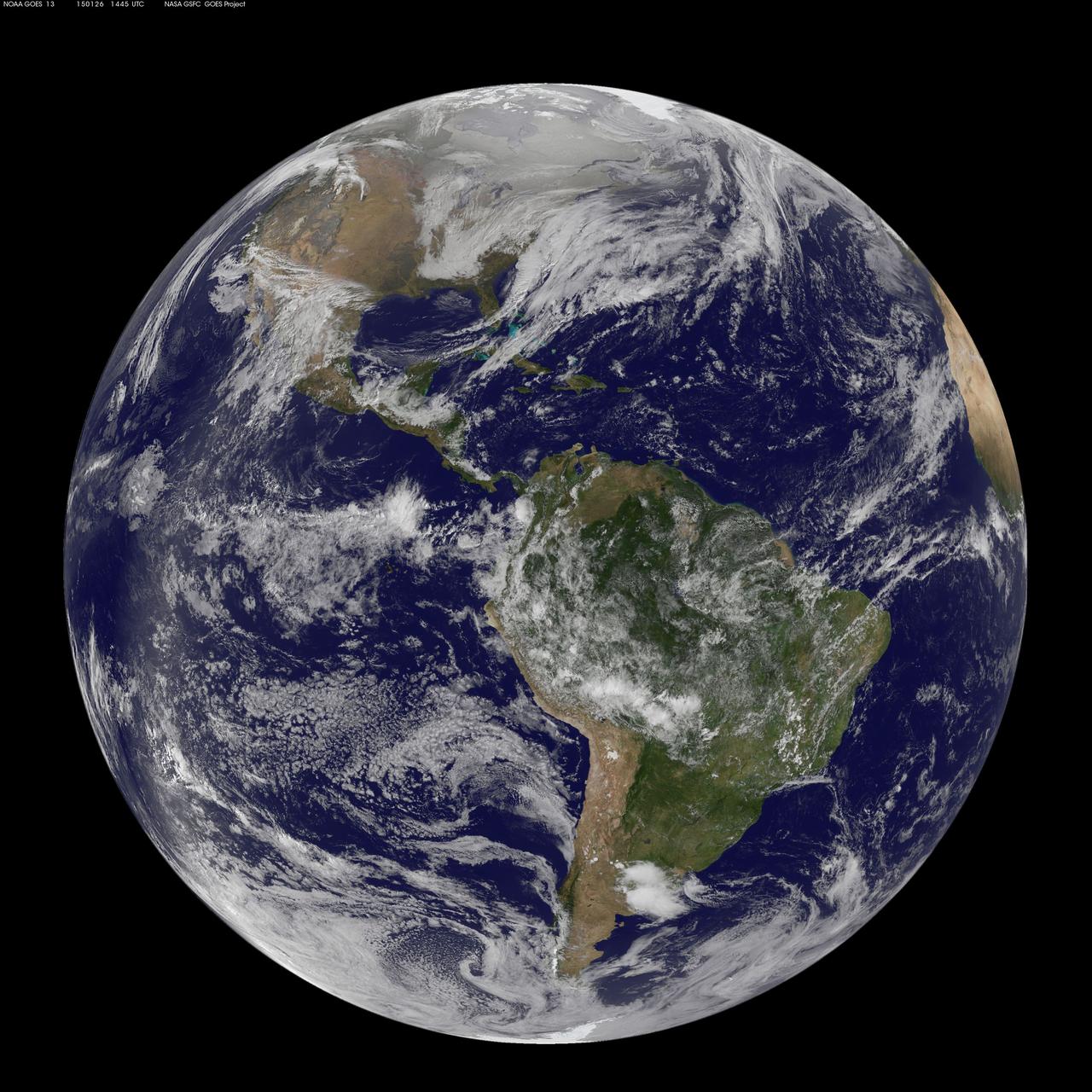
National Weather Service forecasters have been tracking a low pressure area that moved from the Midwest into the Atlantic Ocean today, and is expected to become a strong nor'easter that will bring blizzard conditions to the northeastern U.S. The path of the system was captured in a NASA movie of NOAA's GOES-East satellite imagery. (This GOES 13 image was captured on January 26, 2015 at 1445 UTC.) On Monday, January 26, 2015, the National Weather Service noted: A storm system off the East Coast will continue to strengthen as it develops into a major nor'easter on Monday. As the storm moves up the coast, it is expected to bring snowfall of 1-3 feet or more to many parts of the Northeast through Tuesday evening, including New York City and Boston. Strong, gusty winds will combine with the snow to create blizzard conditions along and near the coast. Winter storm warnings are in effect for the panhandles of West Virginia and Maryland, much of interior New England down to the northern Mid-Atlantic as well as for Nantucket Island, Massachusetts. Winter weather advisories are in effect for portions of the Ohio Valley, Mid-Atlantic and the southern Appalachians as well as a narrow area across interior New England. To create the video and imagery, NASA/NOAA's GOES Project located at NASA's Goddard Space Flight Center in Greenbelt, Maryland overlays the cloud data from NOAA's GOES-East satellite on a true-color image of land and ocean created by data from the Moderate Resolution Imaging Spectroradiometer, or MODIS, instrument that flies aboard NASA's Aqua and Terra satellites. Together, these data create the entire animation of the storm and show its movement. GOES satellites provide the kind of continuous monitoring necessary for intensive data analysis. Geostationary describes an orbit in which a satellite is always in the same position with respect to the rotating Earth. This allows GOES to hover continuously over one position on Earth's surface, appearing stationary. As a result, GOES provide a constant vigil for the atmospheric "triggers" for severe weather conditions such as tornadoes, flash floods, hail storms and hurricanes. For updated information about the storm system, visit NOAA's NWS website: <a href="http://www.weather.gov" rel="nofollow">www.weather.gov</a> For more information about GOES satellites, visit: <a href="http://www.goes.noaa.gov/" rel="nofollow">www.goes.noaa.gov/</a> or goes.gsfc.nasa.gov/ Rob Gutro NASA's Goddard Space Flight Center
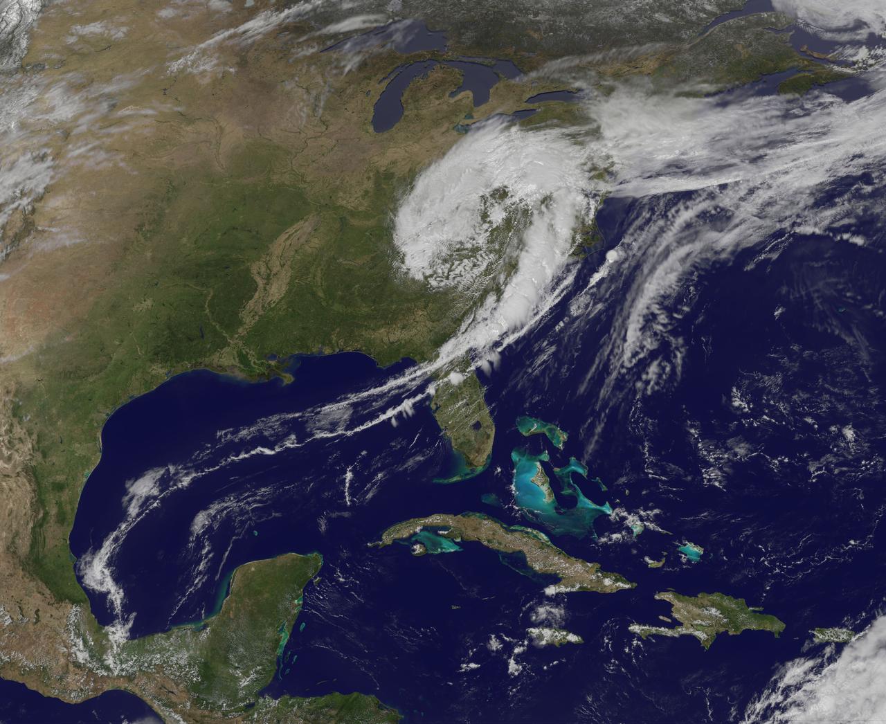
NASA image captured April 12, 2011 at 1731 UTC (1:31 p.m. EDT) A giant swirl of clouds that form an apostrophe-like shape over the eastern U.S. was spotted in visible imagery from the Geostationary Operational Environmental Satellite, GOES-13 on April 12, 2011 at 1731 UTC (1:31 p.m. EDT). The GOES-13 satellite monitors weather over the eastern continental U.S. and Atlantic Ocean, while GOES-11 monitors the western U.S. and the Eastern Pacific Ocean. GOES-13 captured this image of the clouds associated with a strong upper level low pressure area that is moving though the Tennessee River Valley and bringing moderate to heavy rainfall as it moves eastward. The low is forecast by the National Weather Service to bring unsettled conditions to the Mid-Atlantic and then to New England late Tuesday and Wednesday as it tracks northeast. Severe thunderstorms are possible today in extreme eastern Virginia and North Carolina as the cold front associated with the low pushes through that region. Meanwhile, rainfall from the low stretches from Massachusetts south to Florida today. It seems that New Englanders are having a tough time getting warm spring weather and this low won't help as it moves north. The low pressure area may even bring some light to moderate snowfall on the northern fringe of the storm. The GOES series of satellites keep an eye on the weather happening over the continental U.S. and eastern Pacific and Atlantic Oceans. NASA's GOES Project, located at NASA's Goddard Space Flight Center in Greenbelt, Md., procures and manages the development and launch of the GOES series of satellites for NOAA and creates images and animations. The GOES satellites are operated by NOAA. Rob Gutro NASA's Goddard Space Flight Center <b><a href="http://goes.gsfc.nasa.gov/" rel="nofollow">Credit: NOAA/NASA GOES Project</a></b> <b><a href="http://www.nasa.gov/centers/goddard/home/index.html" rel="nofollow">NASA Goddard Space Flight Center</a></b> enables NASA’s mission through four scientific endeavors: Earth Science, Heliophysics, Solar System Exploration, and Astrophysics. Goddard plays a leading role in NASA’s accomplishments by contributing compelling scientific knowledge to advance the Agency’s mission. <b>Follow us on <a href="http://twitter.com/NASA_GoddardPix" rel="nofollow">Twitter</a></b> <b>Join us on <a href="http://www.facebook.com/pages/Greenbelt-MD/NASA-Goddard/395013845897?ref=tsd" rel="nofollow">Facebook</a></b>
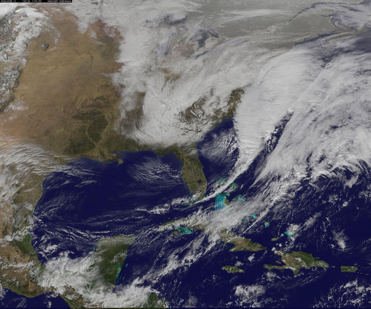
National Weather Service forecasters have been tracking a low pressure area that moved from the Midwest into the Atlantic Ocean today, and is expected to become a strong nor'easter that will bring blizzard conditions to the northeastern U.S. The path of the system was captured in a NASA movie of NOAA's GOES-East satellite imagery. On Monday, January 26, 2015, the National Weather Service noted: A storm system off the East Coast will continue to strengthen as it develops into a major nor'easter on Monday. As the storm moves up the coast, it is expected to bring snowfall of 1-3 feet or more to many parts of the Northeast through Tuesday evening, including New York City and Boston. Strong, gusty winds will combine with the snow to create blizzard conditions along and near the coast. Winter storm warnings are in effect for the panhandles of West Virginia and Maryland, much of interior New England down to the northern Mid-Atlantic as well as for Nantucket Island, Massachusetts. Winter weather advisories are in effect for portions of the Ohio Valley, Mid-Atlantic and the southern Appalachians as well as a narrow area across interior New England. To create the video and imagery, NASA/NOAA's GOES Project located at NASA's Goddard Space Flight Center in Greenbelt, Maryland overlays the cloud data from NOAA's GOES-East satellite on a true-color image of land and ocean created by data from the Moderate Resolution Imaging Spectroradiometer, or MODIS, instrument that flies aboard NASA's Aqua and Terra satellites. Together, these data create the entire animation of the storm and show its movement. GOES satellites provide the kind of continuous monitoring necessary for intensive data analysis. Geostationary describes an orbit in which a satellite is always in the same position with respect to the rotating Earth. This allows GOES to hover continuously over one position on Earth's surface, appearing stationary. As a result, GOES provide a constant vigil for the atmospheric "triggers" for severe weather conditions such as tornadoes, flash floods, hail storms and hurricanes. For updated information about the storm system, visit NOAA's NWS website: <a href="http://www.weather.gov" rel="nofollow">www.weather.gov</a> For more information about GOES satellites, visit: <a href="http://www.goes.noaa.gov/" rel="nofollow">www.goes.noaa.gov/</a> or goes.gsfc.nasa.gov/ Rob Gutro NASA's Goddard Space Flight Center
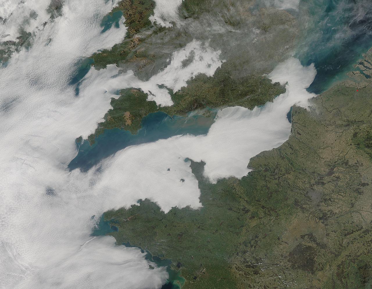
A thick blanket of low clouds covered the English Channel, Celtic Sea and Irish Sea on March 13, 2014. The fog also crept over major cities in the United Kingdom and Ireland. While citizens living in parts of Ireland, England, Wales, Scotland and Northern Ireland were posting ground-based photos of fog-shrouded landscape on social media, the internet and news outlets, the scene was also captured from space. The Moderate Resolution Imaging Spectroradiometer (MODIS) aboard NASA’s Aqua captured this true-color image of the cloudy day at 13:00 UTC (1:00 p.m. in London) on that same day. The dense fog (low clouds) affected air travel, causing the cancellation of hundreds of flights going through London City Airport, where visibility was reported at less than 100 meters (328 ft) – less than the length of an American football field. Flights were also cancelled at Heathrow, Gatwick and Manchester. A private helicopter flying to Northern Ireland went down in by the fog near the Norfolk-Suffolk border, with loss of four lives. Driving was little better in many areas, causing the Met Office to issue a yellow weather warning and to caution drivers of difficult conditions. The lowest visibility of the day was reported at Roches Point weather station. Located at the southeastern tip of Cork Harbor, Ireland, the station reported visibility of less than 50 meters (164 ft) – the length of an Olympic size swimming pool. In this image, the fog-covered Celtic Sea is located in the southwest. Ireland lies under tendrils of low cloud in the northwest corner of the image. Banks of clouds part around England, near the center of the image, and southern Wales (top and center) completely under the foggy blanket. Fog also creeps over the coasts of France, Belgium and the Netherlands on the east side of the English Channel. Credit: NASA/GSFC/Jeff Schmaltz/MODIS Land Rapid Response Team <b><a href="http://www.nasa.gov/audience/formedia/features/MP_Photo_Guidelines.html" rel="nofollow">NASA image use policy.</a></b> <b><a href="http://www.nasa.gov/centers/goddard/home/index.html" rel="nofollow">NASA Goddard Space Flight Center</a></b> enables NASA’s mission through four scientific endeavors: Earth Science, Heliophysics, Solar System Exploration, and Astrophysics. Goddard plays a leading role in NASA’s accomplishments by contributing compelling scientific knowledge to advance the Agency’s mission. <b>Follow us on <a href="http://twitter.com/NASAGoddardPix" rel="nofollow">Twitter</a></b> <b>Like us on <a href="http://www.facebook.com/pages/Greenbelt-MD/NASA-Goddard/395013845897?ref=tsd" rel="nofollow">Facebook</a></b> <b>Find us on <a href="http://instagram.com/nasagoddard?vm=grid" rel="nofollow">Instagram</a></b>
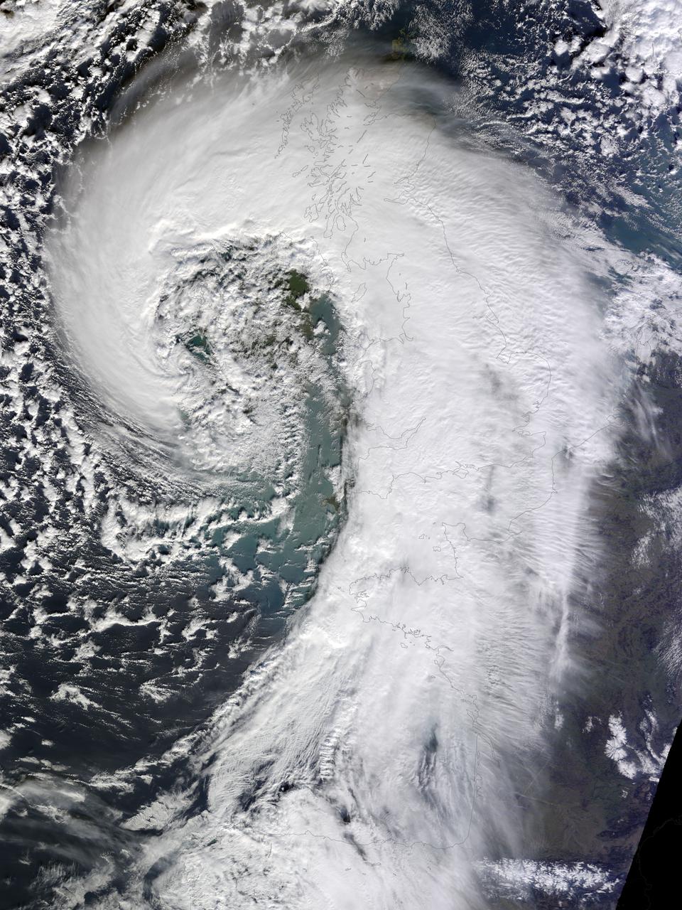
Soggy winters are not unusual in the United Kingdom, but this winter has been in a category of its own. UK Met Office meteorologists had just declared January 2014 the wettest month on record for parts of southern Britain when another series of storms swept across the area in early February. The Moderate Resolution Imaging Spectroradiometer (MODIS) on NASA’s Terra satellite captured this image of an extratropical cyclone bearing down on the United Kingdom on February 12, 2014. Mature extratropical cyclones often feature comma-shaped cloud patterns that are the product of “conveyor belt” circulation. While heavy precipitation is often present near the low-pressure head of the comma, a slot of dry air usually trails the west side of the tail. The storm brought the United Kingdom yet another round of heavy rain, as well as winds that exceeded 160 kilometers (100 miles) per hour. It snarled traffic, disrupted train service, and caused power outages for more than 700,000 people. The also exacerbated severe flooding in southern England. More than 5,800 homes have flooded since early December, according to media reports. Authorities have deployed thousands of soldiers to towns and cities in southern England to help with flood recovery. Meanwhile, the Met Office was forecasting more of the same. They warned that another system bearing heavy rain and winds was lining up to push into the United Kingdom from the southeast on Friday morning. NASA Earth Observatory image by Jesse Allen, using data from the Land Atmosphere Near real-time Capability for EOS (LANCE). Caption by Adam Voiland. More info: <a href="http://earthobservatory.nasa.gov/NaturalHazards/view.php?id=83127" rel="nofollow">earthobservatory.nasa.gov/NaturalHazards/view.php?id=83127</a> Instrument: Terra - MODIS Credit: <b><a href="http://www.earthobservatory.nasa.gov/" rel="nofollow"> NASA Earth Observatory</a></b> <b><a href="http://www.nasa.gov/audience/formedia/features/MP_Photo_Guidelines.html" rel="nofollow">NASA image use policy.</a></b> <b><a href="http://www.nasa.gov/centers/goddard/home/index.html" rel="nofollow">NASA Goddard Space Flight Center</a></b> enables NASA’s mission through four scientific endeavors: Earth Science, Heliophysics, Solar System Exploration, and Astrophysics. Goddard plays a leading role in NASA’s accomplishments by contributing compelling scientific knowledge to advance the Agency’s mission. <b>Follow us on <a href="http://twitter.com/NASAGoddardPix" rel="nofollow">Twitter</a></b> <b>Like us on <a href="http://www.facebook.com/pages/Greenbelt-MD/NASA-Goddard/395013845897?ref=tsd" rel="nofollow">Facebook</a></b> <b>Find us on <a href="http://instagrid.me/nasagoddard/?vm=grid" rel="nofollow">Instagram</a></b>
CAPE CANAVERAL, Fla. - At NASA's Kennedy Space Center in Florida, the support personnel for NASA's STS-132 Tweetup introduce themselves to the participants. NASA is hosting 150 people from around the world and providing them with a behind-the-scenes perspective to share with their followers via the social networking service Twitter. Attendees were randomly selected from more than 1,000 online registrations and include people from more than 30 states, the District of Columbia, Puerto Rico, the Netherlands, New Zealand and England. The Tweeters are being given the chance to meet with shuttle technicians, managers, engineers and astronauts, to take a tour of Kennedy, and to experience the exhilaration of the launch of space shuttle Atlantis' STS-132 mission. A tent was set up especially for the occasion near the countdown clock at Kennedy's Press Site. Atlantis' liftoff is set for 2:20 p.m. EDT on May 14. STS-132 is the 34th mission to the station and the last scheduled flight for Atlantis. For more information on the STS-132 mission objectives, payload and crew, visit http:__www.nasa.gov_mission_pages_shuttle_shuttlemissions_sts132_index.html. Photo Credit: NASA_Amanda Diller
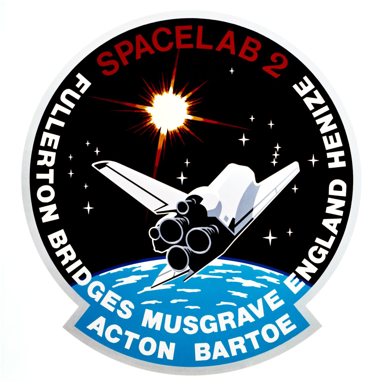
S85-29498 (June 1985) --- The crew members of space shuttle mission STS-51F have chosen as their insignia this design by Houston artist Skip Bradley. The space shuttle Challenger is depicted ascending toward the heavens in search of new knowledge in the field of solar and stellar astronomy, with its Spacelab 2 payload. The constellations Leo and Orion are in the positions they will be in, relative to the sun during the flight. The nineteen stars signify that this will be the 19th STS flight. Crew members for the mission are astronauts C. Gordon Fullerton, commander; Roy D. Bridges, pilot; F. Story Musgrave, Anthony W. England and Karl J. Henize, mission specialist; and payload specialists Loren W. Acton and John David Bartoe. The NASA insignia design for space shuttle flights is reserved for use by the astronauts and for other official use as the NASA Administrator may authorize. Public availability has been approved only in the forms of illustrations by the various news media. When and if there is any change in this policy, which is not anticipated, the change will be publicly announced. Photo credit: NASA

CAPE CANAVERAL, Fla. - At NASA's Kennedy Space Center in Florida, NASA's space shuttle Discovery Flow Director Stephanie Stilson has a rapt audience in the participants of NASA's STS-132 Tweetup. NASA is hosting 150 people from around the world and providing them with a behind-the-scenes perspective to share with their followers via the social networking service Twitter. Attendees were randomly selected from more than 1,000 online registrations and include people from more than 30 states, the District of Columbia, Puerto Rico, the Netherlands, New Zealand and England. The Tweeters are being given the chance to meet with shuttle technicians, managers, engineers and astronauts, to take a tour of Kennedy, and to experience the exhilaration of the launch of space shuttle Atlantis' STS-132 mission. A tent was set up especially for the occasion near the countdown clock at Kennedy's Press Site. Atlantis' liftoff is set for 2:20 p.m. EDT on May 14. STS-132 is the 34th mission to the station and the last scheduled flight for Atlantis. For more information on the STS-132 mission objectives, payload and crew, visit http:__www.nasa.gov_mission_pages_shuttle_shuttlemissions_sts132_index.html. Photo Credit: NASA_Amanda Diller

CAPE CANAVERAL, Fla. - At NASA's Kennedy Space Center in Florida, NASA's Ron Woods, a flight crew equipment specialist, presents one of his space-themed paintings to the participants in NASA's STS-132 Tweetup. NASA is hosting 150 people from around the world and providing them with a behind-the-scenes perspective to share with their followers via the social networking service Twitter. Attendees were randomly selected from more than 1,000 online registrations and include people from more than 30 states, the District of Columbia, Puerto Rico, the Netherlands, New Zealand and England. The Tweeters are being given the chance to meet with shuttle technicians, managers, engineers and astronauts, to take a tour of Kennedy, and to experience the exhilaration of the launch of space shuttle Atlantis' STS-132 mission. A tent was set up especially for the occasion near the countdown clock at Kennedy's Press Site. Atlantis' liftoff is set for 2:20 p.m. EDT on May 14. STS-132 is the 34th mission to the station and the last scheduled flight for Atlantis. For more information on the STS-132 mission objectives, payload and crew, visit http:__www.nasa.gov_mission_pages_shuttle_shuttlemissions_sts132_index.html. Photo Credit: NASA_Amanda Diller

S70-34986 (14 April 1970) --- A group of six astronauts and two flight controllers monitor the console activity in the Mission Operations Control Room (MOCR) of the Mission Control Center (MCC) during the problem-plagued Apollo 13 lunar landing mission. Seated, left to right, are MOCR Guidance Officer Raymond F. Teague; astronaut Edgar D. Mitchell, Apollo 14 prime crew lunar module pilot; and astronaut Alan B. Shepard Jr., Apollo 14 prime crew commander. Standing, left to right, are scientist-astronaut Anthony W. England; astronaut Joe H. Engle, Apollo 14 backup crew lunar module pilot; astronaut Eugene A. Cernan, Apollo 14 backup crew commander; astronaut Ronald E. Evans, Apollo 14 backup crew command module pilot; and M.P. Frank, a flight controller. When this picture was made, the Apollo 13 moon landing had already been canceled, and the Apollo 13 crew men were in trans-Earth trajectory attempting to bring their damaged spacecraft back home.