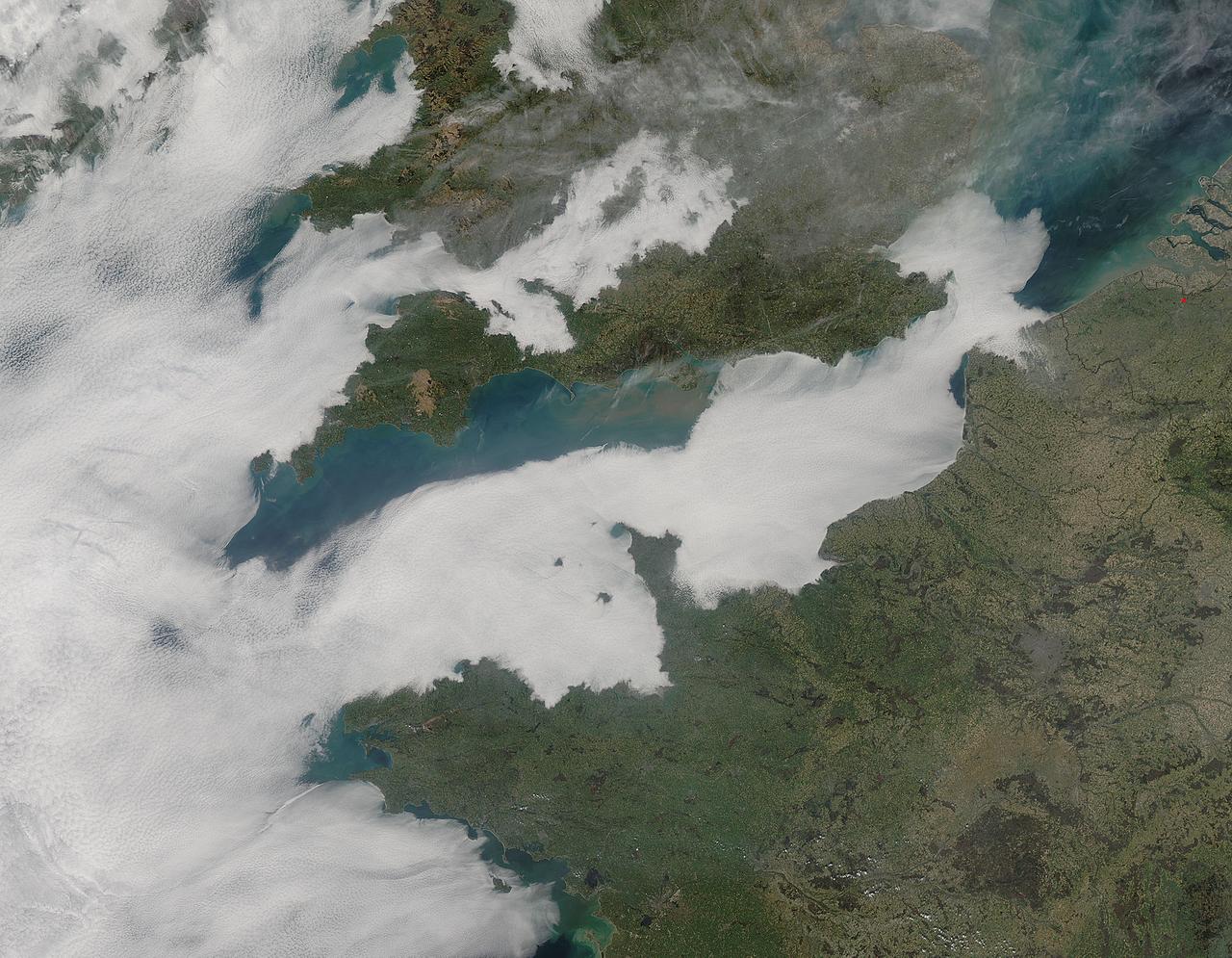
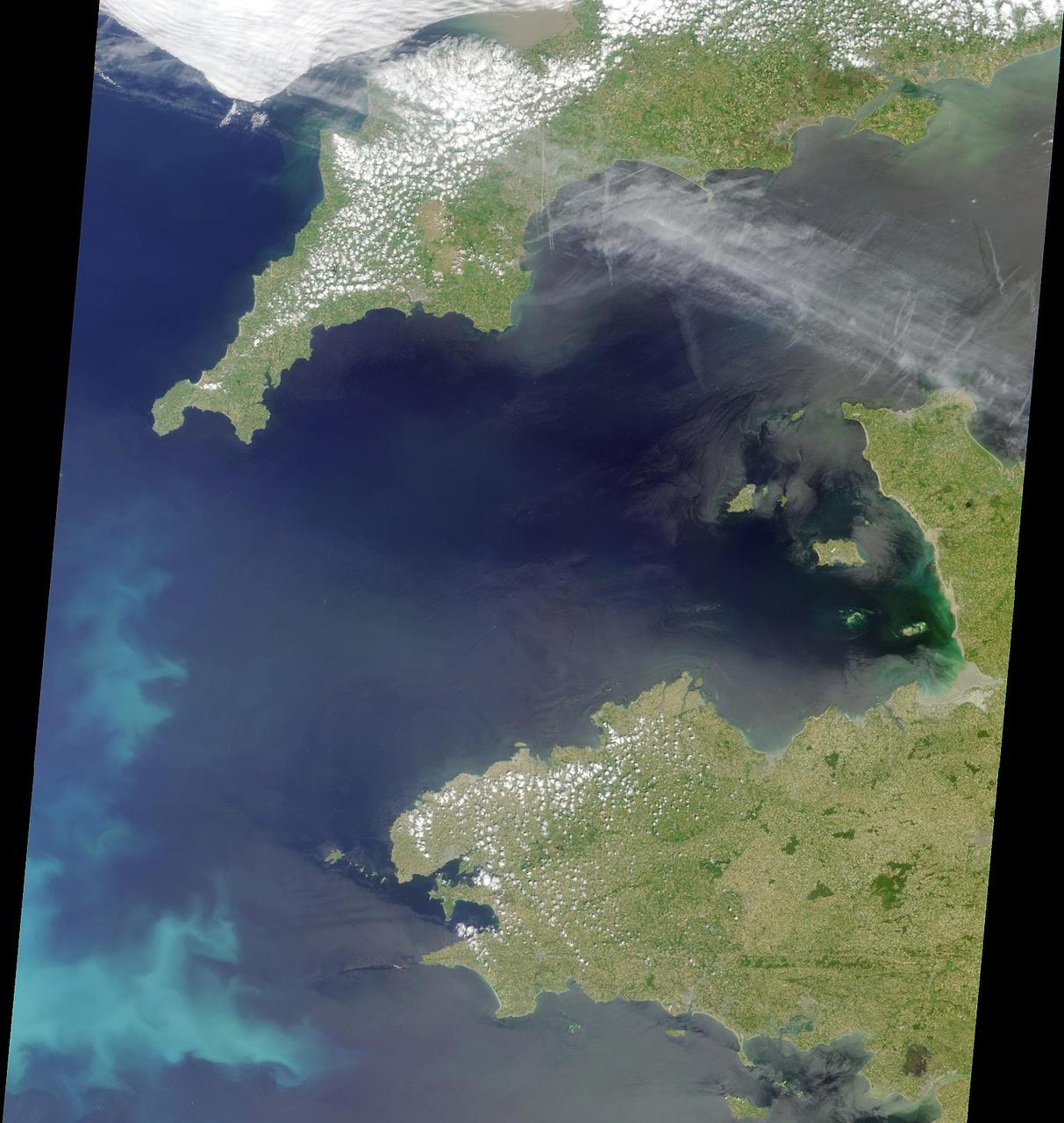
A thick blanket of low clouds covered the English Channel, Celtic Sea and Irish Sea on March 13, 2014. The fog also crept over major cities in the United Kingdom and Ireland. While citizens living in parts of Ireland, England, Wales, Scotland and Northern Ireland were posting ground-based photos of fog-shrouded landscape on social media, the internet and news outlets, the scene was also captured from space. The Moderate Resolution Imaging Spectroradiometer (MODIS) aboard NASA’s Aqua captured this true-color image of the cloudy day at 13:00 UTC (1:00 p.m. in London) on that same day. The dense fog (low clouds) affected air travel, causing the cancellation of hundreds of flights going through London City Airport, where visibility was reported at less than 100 meters (328 ft) – less than the length of an American football field. Flights were also cancelled at Heathrow, Gatwick and Manchester. A private helicopter flying to Northern Ireland went down in by the fog near the Norfolk-Suffolk border, with loss of four lives. Driving was little better in many areas, causing the Met Office to issue a yellow weather warning and to caution drivers of difficult conditions. The lowest visibility of the day was reported at Roches Point weather station. Located at the southeastern tip of Cork Harbor, Ireland, the station reported visibility of less than 50 meters (164 ft) – the length of an Olympic size swimming pool. In this image, the fog-covered Celtic Sea is located in the southwest. Ireland lies under tendrils of low cloud in the northwest corner of the image. Banks of clouds part around England, near the center of the image, and southern Wales (top and center) completely under the foggy blanket. Fog also creeps over the coasts of France, Belgium and the Netherlands on the east side of the English Channel. Credit: NASA/GSFC/Jeff Schmaltz/MODIS Land Rapid Response Team <b><a href="http://www.nasa.gov/audience/formedia/features/MP_Photo_Guidelines.html" rel="nofollow">NASA image use policy.</a></b> <b><a href="http://www.nasa.gov/centers/goddard/home/index.html" rel="nofollow">NASA Goddard Space Flight Center</a></b> enables NASA’s mission through four scientific endeavors: Earth Science, Heliophysics, Solar System Exploration, and Astrophysics. Goddard plays a leading role in NASA’s accomplishments by contributing compelling scientific knowledge to advance the Agency’s mission. <b>Follow us on <a href="http://twitter.com/NASAGoddardPix" rel="nofollow">Twitter</a></b> <b>Like us on <a href="http://www.facebook.com/pages/Greenbelt-MD/NASA-Goddard/395013845897?ref=tsd" rel="nofollow">Facebook</a></b> <b>Find us on <a href="http://instagram.com/nasagoddard?vm=grid" rel="nofollow">Instagram</a></b>
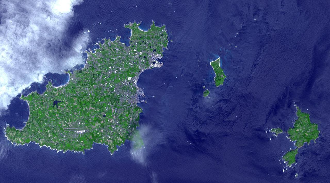
Sark (lower right) is part of the English Channel Islands off the coast of Normandy, France. It is a royal fief, part of the Bailiwick of Guernsey (left side), and has its own set of laws based on Norman law, its own parliament, and exchequer. Until 2008, it was the last feudal state in Europe with hereditary government. Sark is one of the few places in the world where cars are banned. The image was acquired June 16, 2017, covers an area of 14.1 by 25.3 km, and is located at 49.4 degrees north, 2.5 degrees west. With its 14 spectral bands from the visible to the thermal infrared wavelength region and its high spatial resolution of about 50 to 300 feet (15 to 90 meters), ASTER images Earth to map and monitor the changing surface of our planet. ASTER is one of five Earth-observing instruments launched Dec. 18, 1999, on Terra. The instrument was built by Japan's Ministry of Economy, Trade and Industry. A joint U.S./Japan science team is responsible for validation and calibration of the instrument and data products. The broad spectral coverage and high spectral resolution of ASTER provides scientists in numerous disciplines with critical information for surface mapping and monitoring of dynamic conditions and temporal change. Example applications are monitoring glacial advances and retreats; monitoring potentially active volcanoes; identifying crop stress; determining cloud morphology and physical properties; wetlands evaluation; thermal pollution monitoring; coral reef degradation; surface temperature mapping of soils and geology; and measuring surface heat balance. https://photojournal.jpl.nasa.gov/catalog/PIA25859
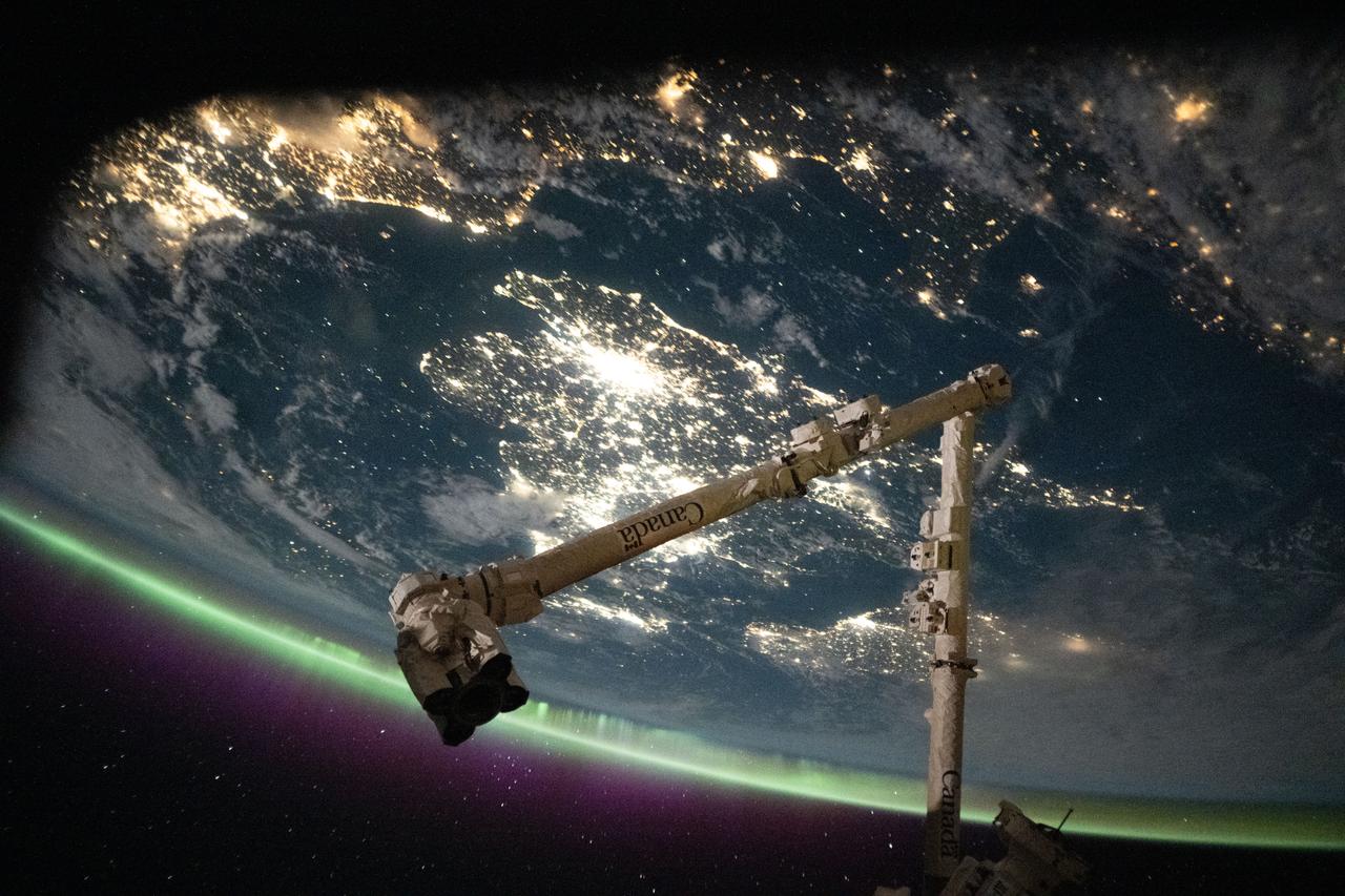
iss073e0698351 (Sept. 13, 2025) --- The English Channel separates the sparkling nighttime coasts of France and England highlighted by an aurora crowning Earth's atmosphere. The sprawling city lights of London are seen at center, while the coastal cities of northern Europe including Amsterdam can be seen at top left. In the foreground, is the Canadarm2 robotic arm. The International Space Station was orbiting 263 miles above France at approximately 11:38 p.m. local time when this photograph was taken.
The Channel Tunnel is a 50.5 km-long rail tunnel beneath the English Channel at the Straits of Dover. It connects Dover, Kent in England with Calais, northern France. This image was acquired by NASA Terra spacecraft.
This image is a natural-color view of the Celtic Sea and English Channel regions, and was acquired by NASA Terra satellite on June 4, 2001 during Terra orbit 7778.
41G-121-139 (5-13 Oct. 1984) --- The Strait of Dover and London, seldom seen in space photography, can be delineated in this medium format camera's scene showing parts of England and France from onboard the Earth-orbiting space shuttle Challenger. Parts of the Thames River can also be traced in the frame. The 41-G crew consisted of astronauts Robert L. Crippen, commander; Jon A. McBride, pilot; and Mission Specialists Kathryn D. Sullivan, Sally K. Ride, and David D. Leestma; along with Canadian astronaut Marc Garneau; and Paul D. Scully-Power, both payload specialists. Photo credit: NASA

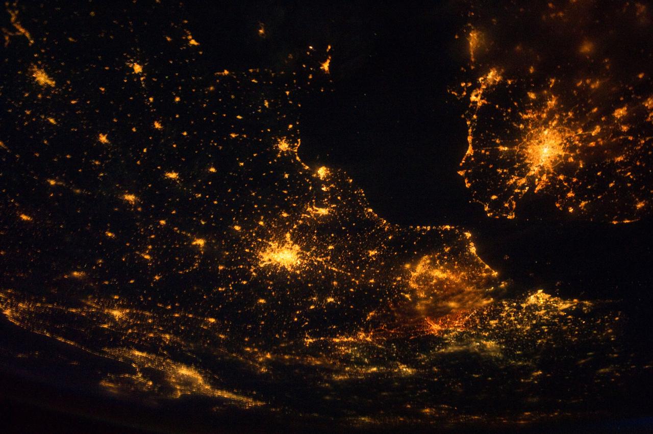
iss058e005276 (Jan. 19, 2019) --- This nighttime shot from the International Space Station taken 258 miles above the English Channel shows the lights of the northern European cities of (clockwise from top right) London, Amsterdam, The Hague, Rotterdam, Antwerp and Brussels and other surrounding cities.
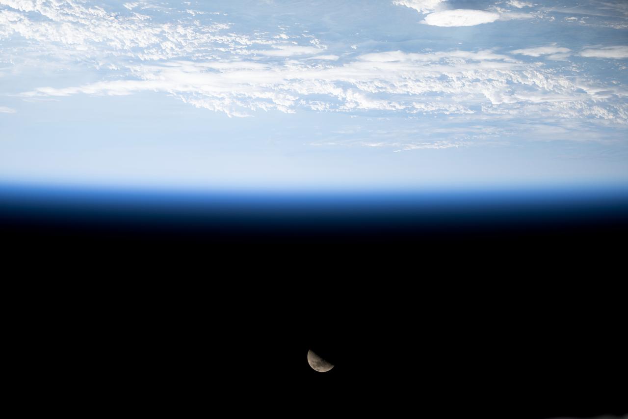
iss071e485735 (Aug. 12, 2024) --- The First Quarter Moon is pictured above Earth's horizon from the International Space Station as it orbited 263 miles above the English Channel in between France and England.
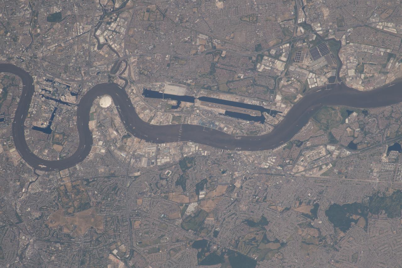
iss056e084656 (June 27, 2018) --- The Canary Wharf financial district, London City Airport and the River Thames in east London, England are pictured as the International Space Station was orbiting across the English Channel.
iss068e053846 (Feb. 12, 2023) --- The northwestern coastal regions of Brittany and Normandy in France meet here on the English Channel in this photograph from the International Space Station as it orbited 264 miles above.
iss065e083895 (June 1, 2021) --- The sun's glint beams across the English Channel and the North Sea in between southern England and the coasts of France, Belgium and The Netherlands, in this photograph from the International Space Station as it orbited 263 miles above.
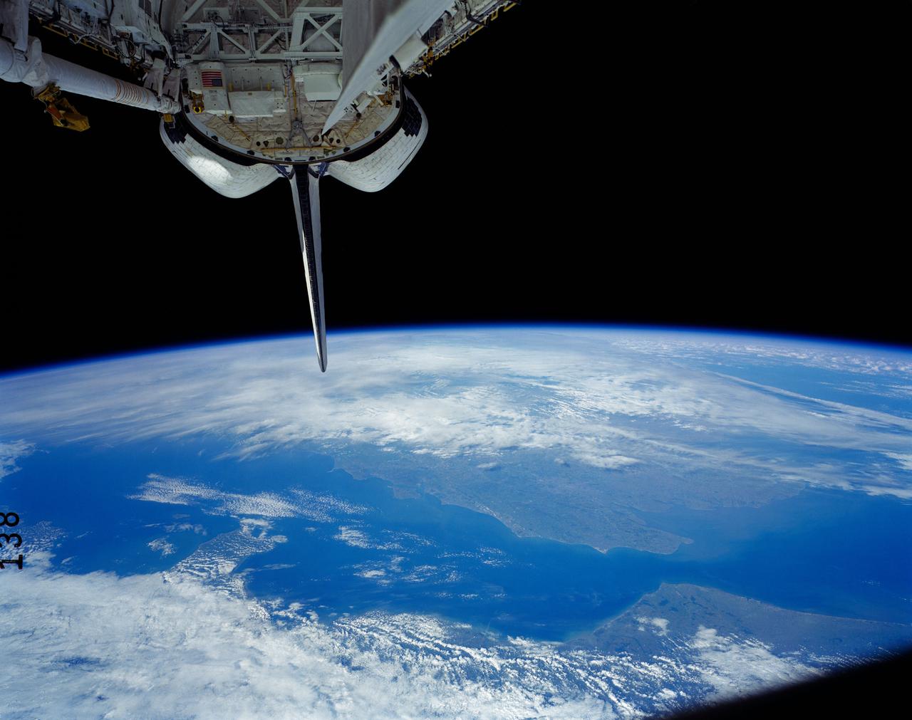
41G-121-138 (5-13 Oct 1984) --- A view of the Earth's horizon featuring France and England. The Strait of Dover and the English channel are visible behind the tail (vertical stabilizer) of Challenger. The remote manipulator system (RMS arm rests in its "stow" position at upper left corner.
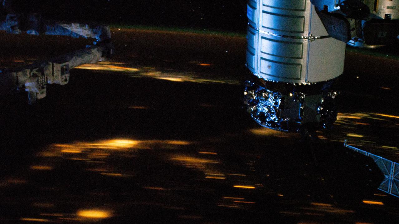
iss068e060810 (Feb. 28, 2023) --- At top right, is the Northrop Grumman Cygnus space freighter berthed to the International Space Station's Unity module. The orbital outpost was soaring 262 miles above the English Channel off the coast of France in this nighttime photograph from an external high-definition camera.
iss071e207619 (June 23, 2024) --- The French port city of Le Havre on the river Seine at the mouth of the English Channel is pictured from the International Space Station as it orbited 264 miles above. The cable-stayed bridge Pont de Normandie crosses the Seine and links Le Havre to the city of Honfleur in France's Normandy region.
iss056e127185 (Aug. 6, 2018) --- The International Space Station was orbiting above Germany when an Expedition 56 crew member photographed the English Channel and the North Sea, lit by the Sun's glint, separating the United Kingdom from the European countries of France, Belgium and the Netherlands.
iss057e045679 (Oct. 14, 2018) --- The International Space Station was orbiting 257 miles above the English Channel when this photograph was taken of the Northern European countries of Denmark, Germany, Sweden and Poland. Japan's H-II Transfer Vehicle-7, or HTV-7 resupply ship, is pictured at right attached the Harmony module.
SL3-121-2445 (July-September 1973) --- An oblique view of a portion of Great Britain looking northeastward across England and Wales, as photographed by one of the Skylab 3 crewmen aboard the Skylab space station in Earth orbit. The picture was taken with a hand-held 70mm Hasselblad camera using a 100mm lens and SO-368 medium-speed Ektacrome film. The English Channel is at lower right. The Bristol Channel is at lower left. The North Sea with much cloud cover is in the background. Photo credit: NASA

Assembling the Gossamer Albatross II in hangar
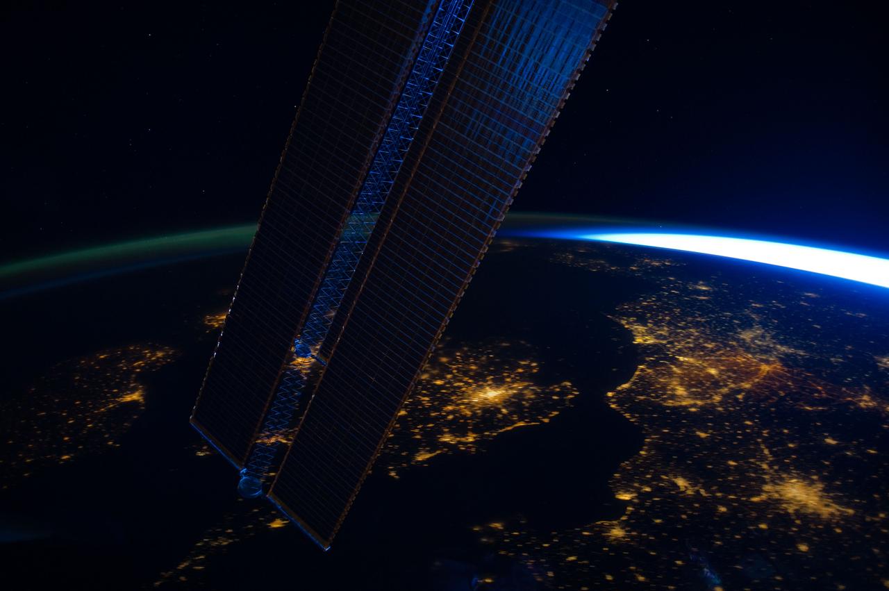
ISS030-E-064161 (2 Feb. 2012) --- Parts of a number of European nations appear in this nighttime image photographed from the International Space Station. The scene, captured by one of the Expedition 30 crew members, shows the British Isles (left, partially obstructed by one of the space station's solar array panels) with London just right of bottom center; the English Channel, which is dark; Paris (lower right corner); and the Netherlands (right side). The greenish airglow is fairly uniform and minor until it transitions to daybreak on the right.
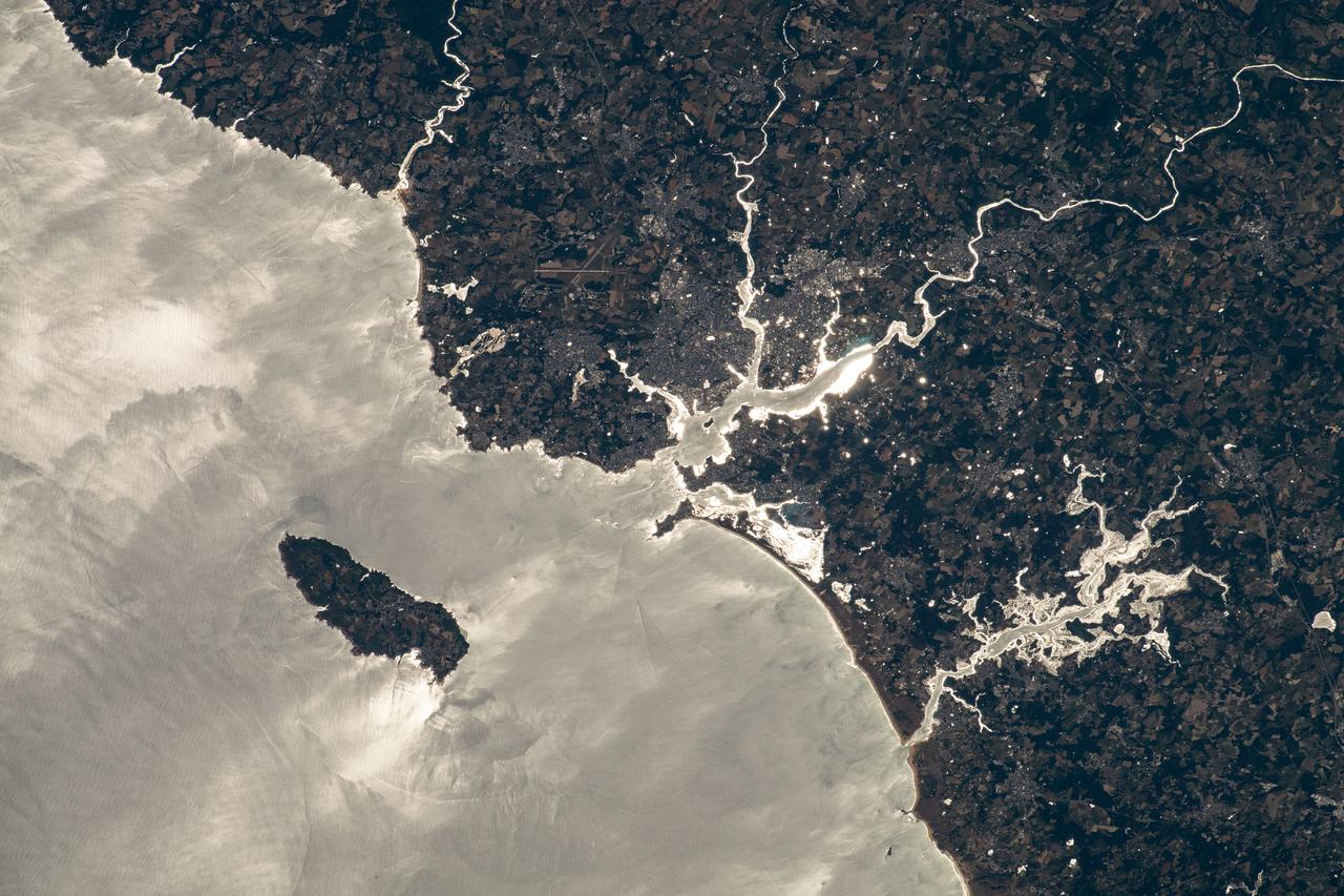
iss067e128929 (June 13, 2022) --- The island of Groix is pictured off the northwestern coast of France with the Atlantic Ocean beaming from the sun's glint in this photograph from the International Space Station as it orbited 264 miles above the English Channel. The rivers (from top left to bottom right) La Laïta, Blavet, and Scorf, including the rivière d'Étel, are seen emptying into the Atlantic.
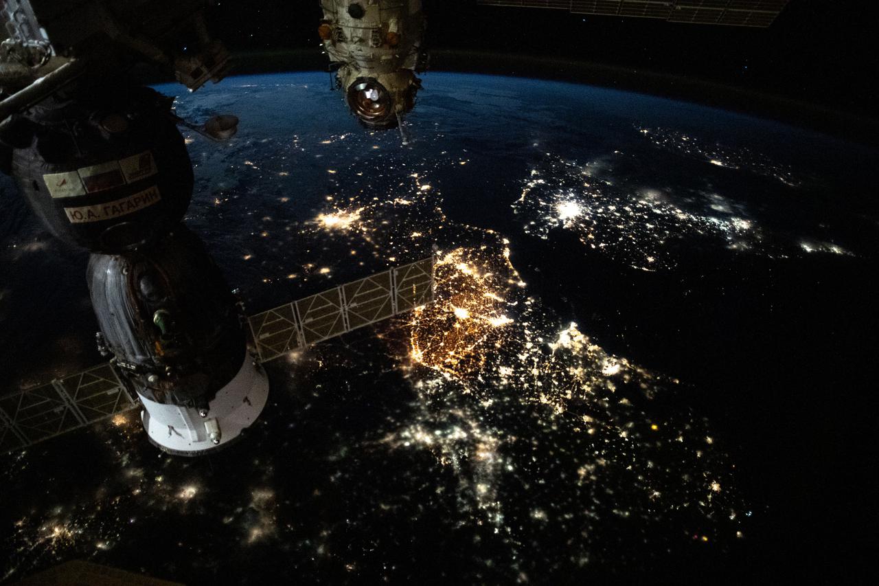
iss065e385473 (Sept. 15, 2021) --- The prominent city lights of Europe from Amsterdam to Paris and London across the English Channel are pictured as the International Space Station orbited 265 miles above the continent. The Soyuz MS-18 crew ship (left) and a portion of the Nauka multipurpose laboratory module (right) are pictured docked to the station's Russian segment
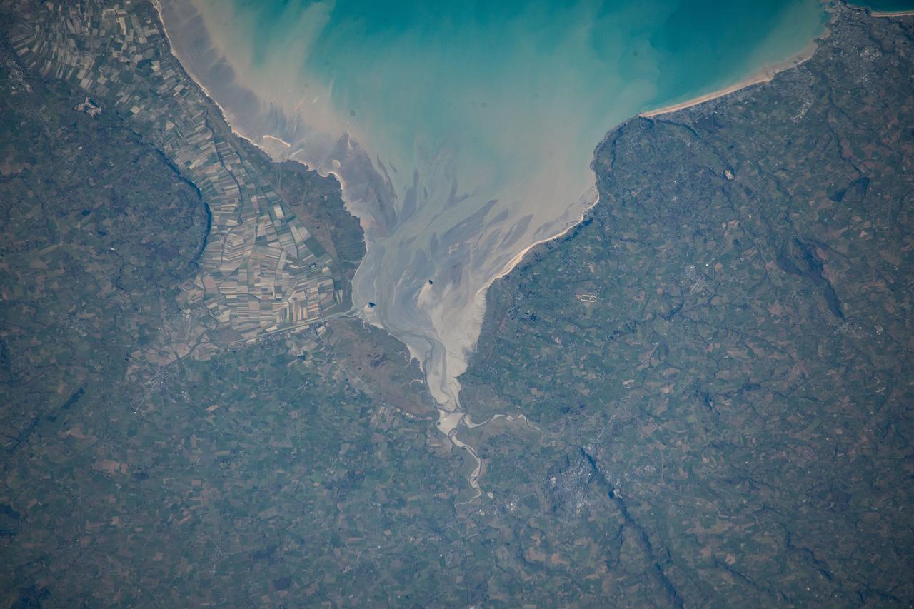
STS060-94-007 (3-11 Feb 1994) --- The Isle of Wight, over 380 square kilometers, is a diamond-shaped island located off the south coast of England. Separated from the mainland by The Solent, a narrow channel of water, the island is a popular resort area due to its scenery and mild climate. Sediment from English Lowland drainage systems, most notably the River Test, is visible entering The Solent and spilling into the English Channel. At the tip of the linear, northwestward inlet is the mouth of the Test and the city of Southampton, discernible as a small patch of lighter gray. Further east is a series of protected bays which are, from west to east: Portsmouth Harbour, Langstone Harbour, and Chichester Harbour. The city of Portsmouth is the location of Great Britain's chief naval station and arsenal. Portsmouth houses numerous ships of past and present glory. Two of the most notable vessels in Portsmouth are the 104-gun Victory, and the remains of the Mary Rose. The renowned HMS Victory, still carried on active duty rolls of the Royal Navy, and the acting Post Ship of the Royal Navy Base Commander, was built in 1765. The HMS Victory was severely damaged and dismasted in battle. A careful inspection of the original film will show the 175-foot long HMS Victory in this frame. According to NASA geologists it is extremely unusual for Portsmouth to be this cloud-free. It has been a site of some interest for many Space Shuttle missions during the past 10 years.
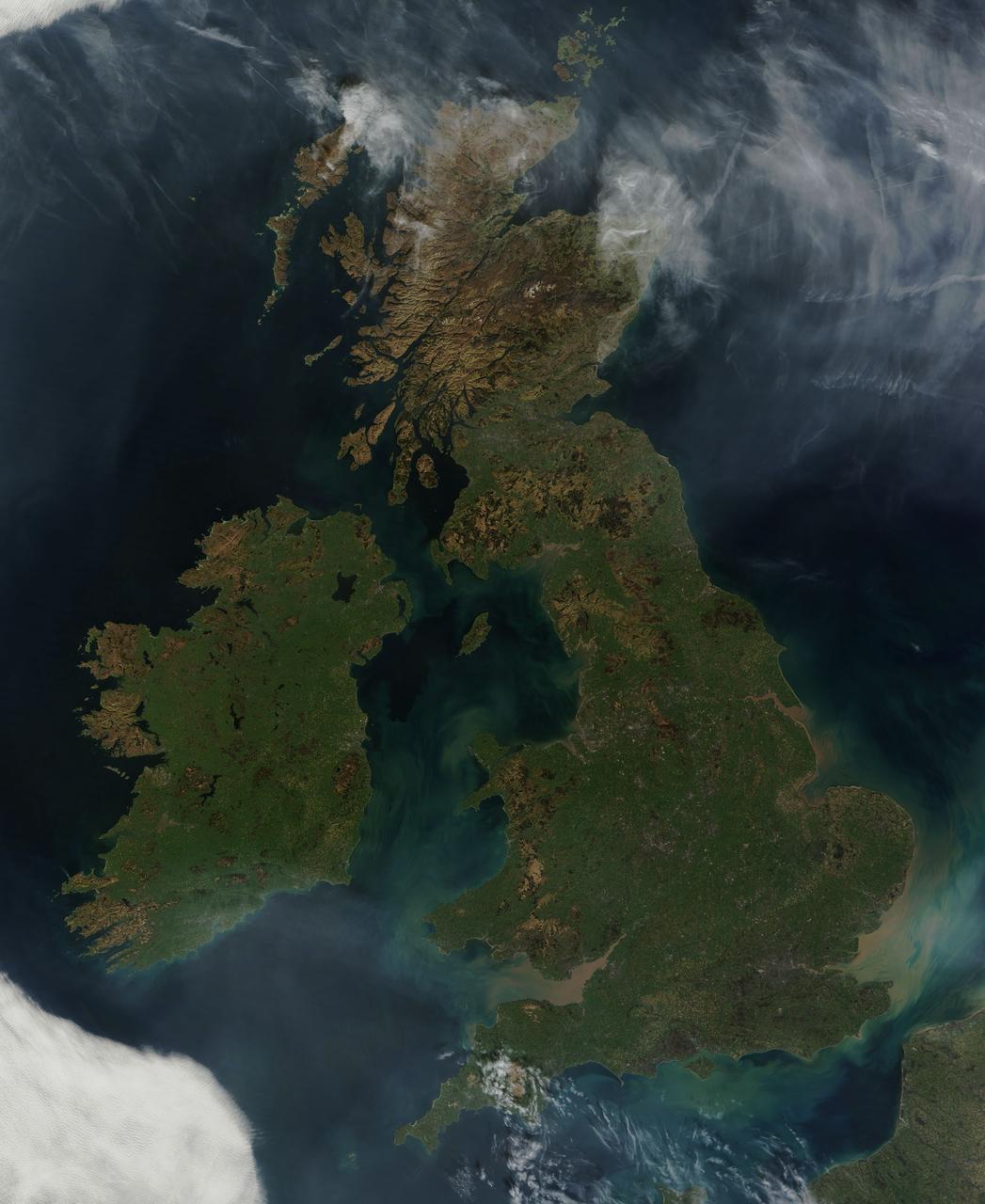
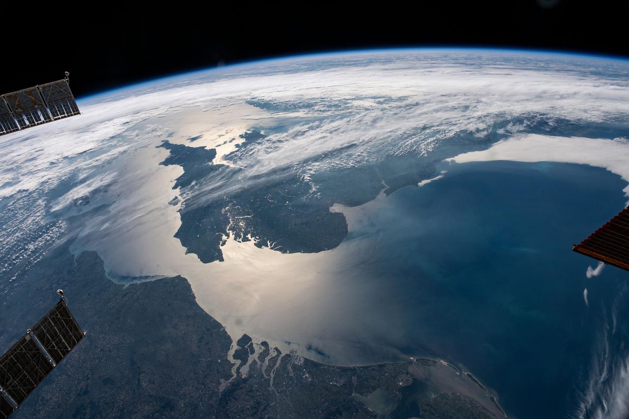
NASA image acquired March 26, 2012 This nearly cloud-free view of Great Britain and Ireland was acquired by the Moderate Resolution Imaging Spectroradiometer (MODIS) aboard NASA’s Terra satellite on March 26, 2012. Just a few days into spring, most of the land appears green, although not quite as brilliant as the summertime hues that give Ireland the nickname “the Emerald Island”. The islands of Ireland (west) and Great Britain (east) are separated by the Irish Sea, which is filled with the turquoise, green and tan swirls typical of sediment, although blooming algae could also contribute some color to the waters. To the southeast, the English Channel separates the island of Great Britain from France (south) and Belgium (north). London can be seen as a gray circle situated inland on the tan-colored River Thames. The sediment from the Thames flows into the English Channel due east of London. The United Kingdom is made up of Wales, Scotland and England, all located primarily on the island of Great Britain, and of Northern Ireland, which comprises the northern section of the island of Ireland. Dublin, in the Republic of Ireland, can be seen as a gray smudge on the eastern coast of the island. Almost due west Galway can be seen as a linear gray streak on the northern coast of Galway Bay, with the blue waters of Loch Corrib to the north. Most of the United Kingdom and Ireland are part of the Celtic broadleaf forest ecoregion, where acid-loving oak and mixed oak forests abound, along with fen and swamp forests and ombrotrophic mires. A portion of the Scottish Highlands, in the north of Great Britain, are covered by the Caledon conifer forest ecoregion. The Caledonia conifers once covered a large area of Scotland, but now only about 1% of the original forest survives, mostly high in the cooler areas of the Highlands. NASA/GSFC/Jeff Schmaltz/MODIS Land Rapid Response Team <b><a href="http://www.nasa.gov/audience/formedia/features/MP_Photo_Guidelines.html" rel="nofollow">NASA image use policy.</a></b> <b><a href="http://www.nasa.gov/centers/goddard/home/index.html" rel="nofollow">NASA Goddard Space Flight Center</a></b> enables NASA’s mission through four scientific endeavors: Earth Science, Heliophysics, Solar System Exploration, and Astrophysics. Goddard plays a leading role in NASA’s accomplishments by contributing compelling scientific knowledge to advance the Agency’s mission. <b>Follow us on <a href="http://twitter.com/NASA_GoddardPix" rel="nofollow">Twitter</a></b> <b>Like us on <a href="http://www.facebook.com/pages/Greenbelt-MD/NASA-Goddard/395013845897?ref=tsd" rel="nofollow">Facebook</a></b> <b>Find us on <a href="http://instagrid.me/nasagoddard/?vm=grid" rel="nofollow">Instagram</a></b>
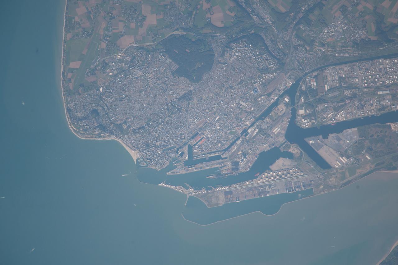
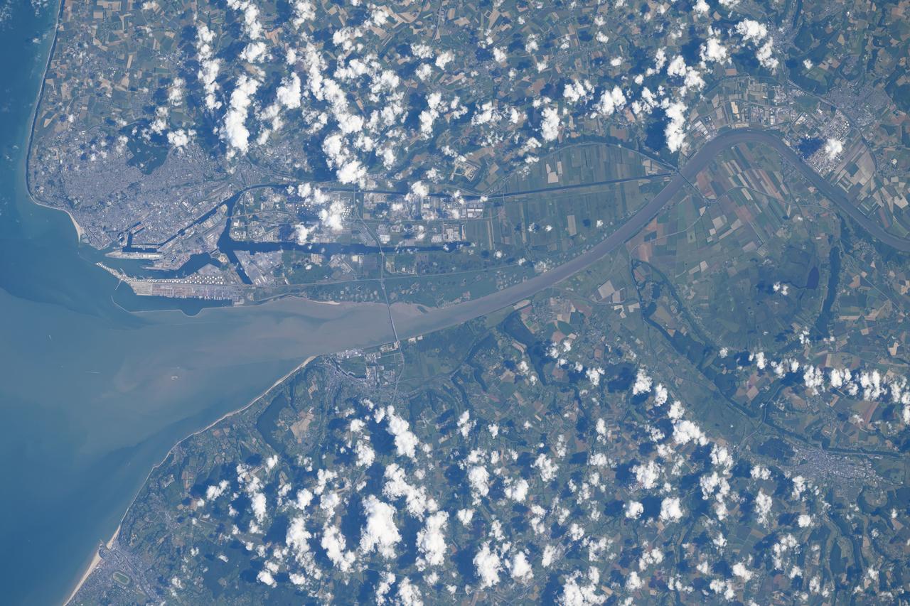
ISS037-E-021618 (26 Oct. 2013) --- Le Havre, France is featured in this image photographed by an Expedition 37 crew member on the International Space Station. The port city of Le Havre, France is located at the confluence of the Seine River and the English Channel along the northern coastline of the country (Upper Normandy region). Le Havre is the largest container port in France, and the second largest in terms of total traffic after Marseille. The extensive port facilities, visible at center, include numerous docks (large cargo ships are clearly visible in this detailed photograph), storage tanks for petro- and other chemicals, and large industrial and warehouse facilities with white rooftops. The port also serves seagoing pleasure cruise vessels. The southern edge of the port facility along the Seine includes a seawall-enclosed ship turning area (lower center). The Montgeon Forest, visible as a large green region at upper center, includes 200 hectares of woodland and 30 hectares of meadows and lawns. The urban area of Le Havre, to the north of the port facilities, was largely destroyed during World War II. After the war, the city was rebuilt following the vision of architect Auguste Perret. Perret favored the use of reinforced and precast concrete in building structures, and much of the city built between 1945 and 1964 follows his plan in both form and materials ? leading to the designation of Le Havre as a UNESCO World Heritage Site.
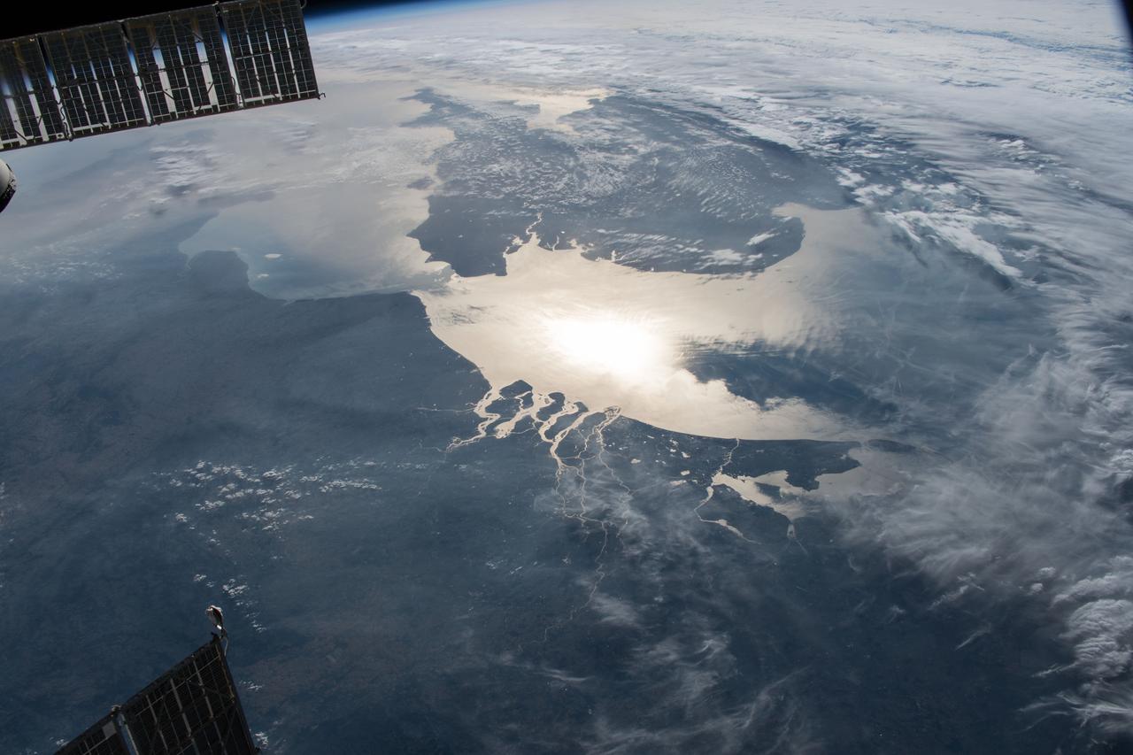
ISS028-E-020276 (2 Aug. 2011) --- This photograph of polar mesospheric clouds was acquired at an altitude of just over 202 nautical miles (about 322 kilometers) in the evening hours (03:19:54 Greenwich Mean Time) on Aug. 2, 2011, as the International Space Station was passing over the English Channel. The nadir coordinates of the station were 49.1 degrees north latitude and 5.5 degrees west longitude. Polar mesospheric clouds (also known as noctilucent, or ?night-shining? clouds) are transient, upper atmospheric phenomena that are usually observed in the summer months at high latitudes (greater than 50 degrees) of both the Northern and Southern Hemispheres. They appear bright and cloudlike while in deep twilight. They are illuminated by sunlight when the lower layers of the atmosphere are in the darkness of Earth?s shadow. The horizon of Earth appears at the bottom of the image, with some layers of the lower atmosphere already illuminated by the rising sun. The higher, bluish-colored clouds look much like wispy cirrus clouds, which can be found as high as 60,000 feet (18 kilometers) in the atmosphere. However noctilucent clouds, as seen here, are observed in the mesosphere at altitudes of 250,000 to 280,000 feet (about 76 to 85 kilometers). Astronaut observations of polar mesospheric clouds over northern Europe in the summer are not uncommon.
ISS028-E-024360 (10 Aug. 2011) --- This night time view of northwestern Europe is featured in this image photographed by an Expedition 28 crew member on the International Space Station. Several of the oldest cities of northwestern Europe are highlighted in this photograph taken at 00:25:26 Greenwich Mean Time (GMT). While the landscape is dotted with numerous clusters of lights from individual urban areas, the metropolitan areas of London (United Kingdom), Paris (France), Brussels (Belgium) and Amsterdam (Netherlands) stand out due to their large light ?footprints?. The metropolitan area of Milan, Italy is also visible at lower left. This photograph was taken with a short camera lens, providing the large field of view recorded in the image. To give a sense of scale, the centers of the London and Paris metropolitan areas are approximately 340 kilometers distant from each other. The image is also oblique, or taken while looking outward at an angle from the station; this tends to foreshorten the image, making the distance between Paris and Milan (approximately 640 kilometers) appear less than that of Paris to London. In contrast to the land surface defined by the city lights, the English Channel at right presents a uniform dark appearance. Similarly, the Alps (bottom center) to the north of Milan are also largely devoid of lights. While much of the atmosphere was clear at the time the image was taken, the lights of the Brussels metropolitan area are dimmed by thin cloud cover.
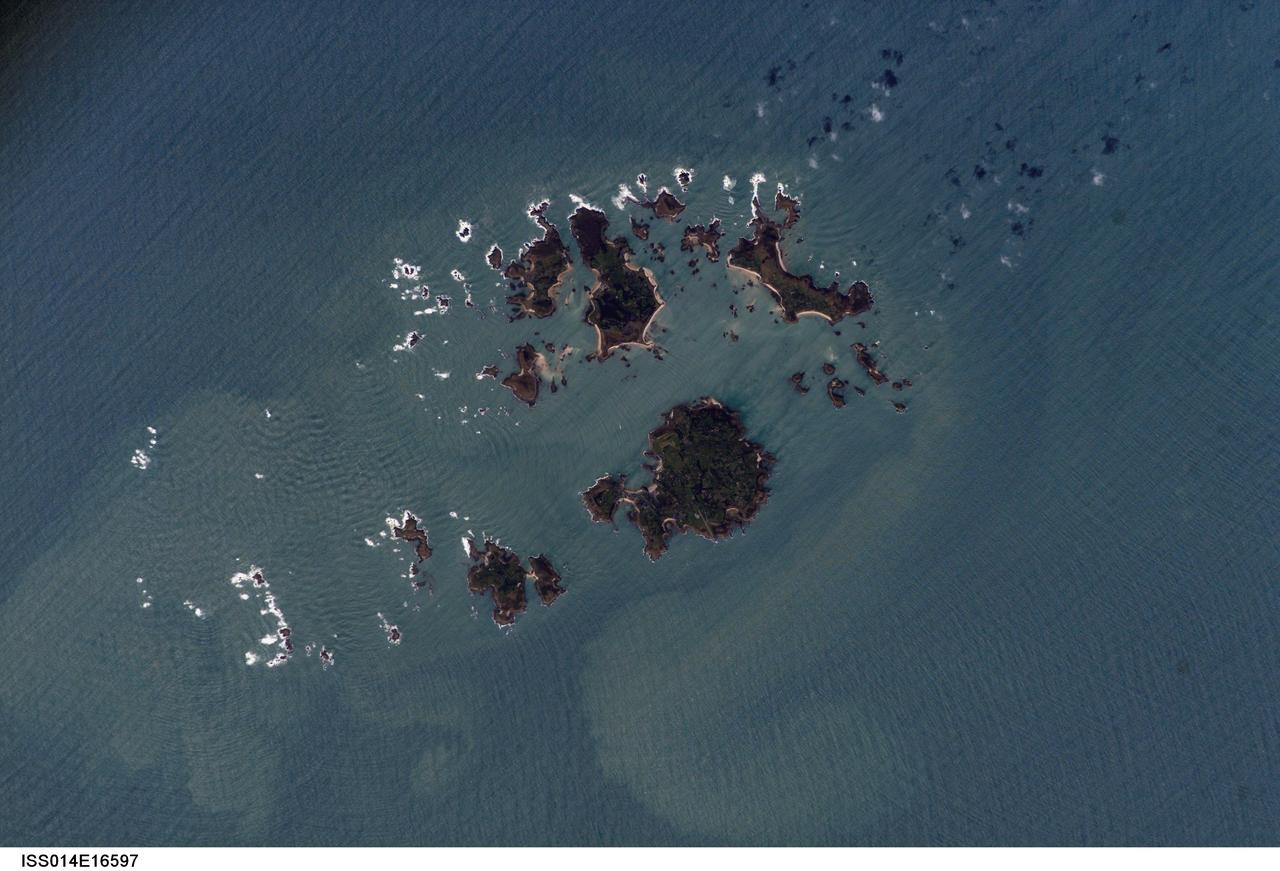
ISS014-E-16597 (10 March 2007) --- Isles of Scilly, United Kingdom is featured in this image photographed by an Expedition 14 crewmember on the International Space Station. The Isles of Scilly, an archipelago of approximately 150 islands, is located some 44 kilometers southwest of the westernmost point of England (Land's End). According to scientists, the islands are an erosional remnant of an ancient granite intrusion, and are notable because they have been inhabited for over 4000 years. Historical and geological evidence cited by NASA scientists on the Isles indicates that many of the islands were larger and/or connected in the recent past--this could be due to local subsidence, rising sea levels, or a combination of both factors. Even today, it is possible to walk between certain islands during low tides. The Isles have been designated a United Kingdom Area of Outstanding Natural Beauty due to their unique landscape, ecology, and historical significance. The potential effect of rising sea level on the Isles is a primary concern for both long-term ecosystem health and human habitability. This image illustrates the geographic configuration of the archipelago, and its effect on ocean wave patterns. Long linear swells oriented northeast-southwest and moving to the southeast (from upper left to lower right) are diffracted (bent) as they approach the coastlines and small shoals of the Isles. The wave diffraction forms complex interacting surface patterns--this is most clearly visible southwest of St. Mary's island (left). The dominant ocean wave pattern resumes to the southeast of St. Mary's, but with an additional northwest-southeast oriented pattern superimposed, possibly due to winds originating in the English channel to the east (not shown). Suspended, tan-colored sediments visible within and around the archipelago are locally derived from continuing wave erosion of the granite forming the islands and remobilization of beach sands. Bright white areas in the photograph are waves breaking on shoals.
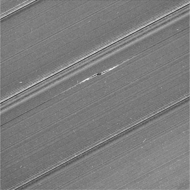
This view from NASA's Cassini spacecraft shows Cassini's best image of the propeller feature known informally as Bleriot. The propeller is named after Louis Bleriot, the French engineer and aviator who in 1909 was the first person to fly across the English Channel. This is the third and final propeller to be targeted for a close flyby observation during Cassini's ring-grazing orbits (the period from Nov. 2016 to April 2017 when Cassini's orbit passed just outside the main rings). Because propellers are seen in the outermost parts of the main rings, the ring-grazing orbits provided Cassini's best opportunity to see them up close. Many small, bright specks and linear, scratch-like artifacts are visible in the image. These artifacts are due to cosmic rays and particles of radiation near the planet striking the camera detector during the exposure. Bleriot is the largest of the propellers in Saturn's rings. The wavy features embedded in the propeller structure indicate that its central moonlet is some 60 percent wider than that of Santos-Dumont, which means the Bleriot moonlet is about four times more massive. Cassini scientists have been tracking the orbit of this object for the past decade, tracing the effect that the ring has upon it. Because it is the biggest propeller, it is more easily seen in lower-resolution images than other propellers, and thus it can be spotted in the most images by far. Here, as Cassini moved in close to the rings as part of its ring-grazing orbits, it was able to obtain this extreme close-up view of the propeller, which enables researchers to examine its effects on the ring as never before. These views, and others like them, will inform models and studies in new ways going forward. This image was taken on the unilluminated side of the rings, where sunlight filters through the backlit ring. Like a frosted window, Saturn's rings look different depending on whether they are seen fully sunlit or backlit. On the lit side, the rings look darker where there is less material to reflect sunlight. On the unlit side, some regions look darker because there is less material, but other regions look dark because there is so much material that the ring becomes opaque. Most dramatically in this image, a dark band cuts deeply through the middle of Bleriot's propeller. It is much more prominent than the similar dark band in the unlit-side image of the Santos-Dumont propeller, indicating that Bleriot stirs up the ring particles to much higher densities than does Santos-Dumont. The dark bands are regions where the density is so high that the ring becomes opaque to the sunlight filtering through the rings. As in Cassini's other propeller close-up images, the central moonlet itself seems to be obscured by the stirred-up ring material around it, so that it cannot be directly seen. It would be about three pixels across, and lies at the center of the propeller structure. The image was taken using the Cassini spacecraft's narrow-angle camera on April 12. Image scale in this view is 0.3 mile (500 meters) per pixel. The sun-ring-spacecraft angle, or phase angle, is 83 degrees. https://photojournal.jpl.nasa.gov/catalog/PIA21447