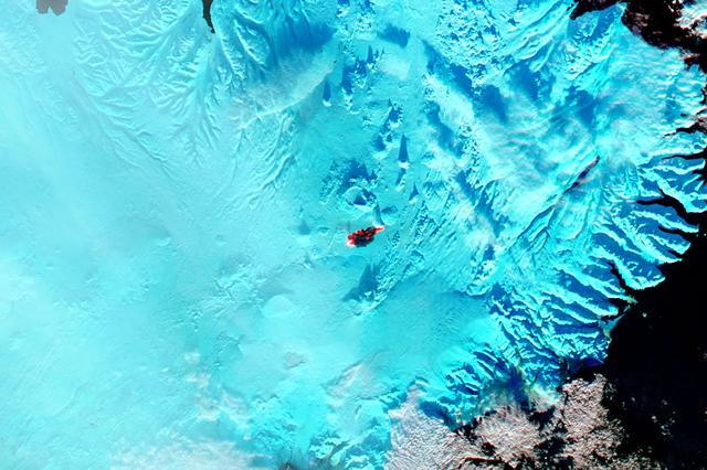
The main caldera of Bardarbunga volcano is tucked beneath Iceland’s largest glacier, Vatnajökull. Beginning in August, 2014, red-hot basaltic lava originating from Bardarbunga has been pouring from fissures just north of Vatnajökull, creating the massive Holuhraun lava field. As of January 6, 2015, the Holuhraun lava field had spread across more than 84 square kilometers (32 square miles), making it larger than the island of Manhattan. Holuhraun is Iceland’s largest basaltic lava flow since the Laki eruption in 1783–84, an event that killed 20 percent of the island’s population. Scientists from the University of Iceland’s Institute of Earth Sciences have estimated the thickness of the lava field based on data from surveillance flights. On average, the eastern part was about 10 meters (33 feet) thick, the center was 12 meters, and the western part was 14 meters. Their preliminary analysis put the volume of lava at 1.1 cubic kilometers, enough for the eruption to be considered a flood basalt. While Holuhraun continues to spew copious amounts of lava and sulfur dioxide, some observations suggest the eruption may be slowing down. As Edinburgh University volcanologist John Stevenson noted on his blog, Icelandic scientists have shown that the sinking (subsidence) of the caldera has declined from 80 centimeters (31 inches) to 25 centimeters per day—a sign that less magma is moving toward the surface. In addition, magnitude 5 or higher earthquakes that used to occur daily are now happening about once a week. Meanwhile, satellite observations of heat flux show a decline from more than 20 gigawatts in early September to fewer than 5 gigawatts by the end of November. As reported by Volcano Discovery, one bold scientist has even suggested that it is reasonable to forecast that the eruption may be over by March, 2015. The Moderate Resolution Imaging Spectrometer (MODIS) aboard NASA’s Aqua satellite flew over Iceland on January 18, 2015 and captured a false-color image of the lava field. In this image, clouds are bright white, cold snow is electric blue, and the North Atlantic Ocean is inky blue-black. Fresh lava appears bright red, while newly formed basaltic rock in the lava field, cooler than the fresh lava, appears black. Credit: NASA/GSFC/Jeff Schmaltz/MODIS Land Rapid Response Team <b><a href="http://www.nasa.gov/audience/formedia/features/MP_Photo_Guidelines.html" rel="nofollow">NASA image use policy.</a></b> <b><a href="http://www.nasa.gov/centers/goddard/home/index.html" rel="nofollow">NASA Goddard Space Flight Center</a></b> enables NASA’s mission through four scientific endeavors: Earth Science, Heliophysics, Solar System Exploration, and Astrophysics. Goddard plays a leading role in NASA’s accomplishments by contributing compelling scientific knowledge to advance the Agency’s mission. <b>Follow us on <a href="http://twitter.com/NASAGoddardPix" rel="nofollow">Twitter</a></b> <b>Like us on <a href="http://www.facebook.com/pages/Greenbelt-MD/NASA-Goddard/395013845897?ref=tsd" rel="nofollow">Facebook</a></b> <b>Find us on <a href="http://instagram.com/nasagoddard?vm=grid" rel="nofollow">Instagram</a></b>
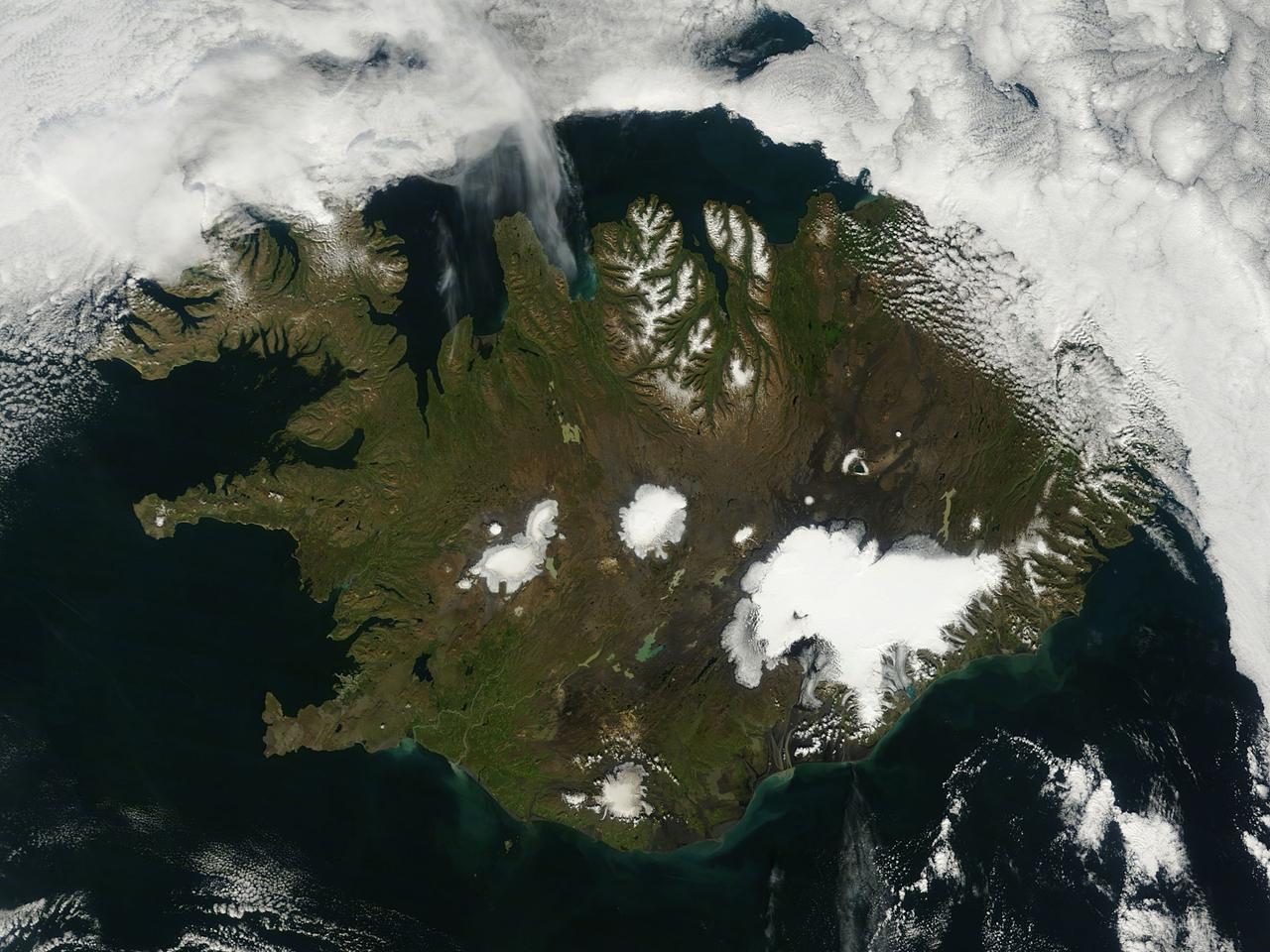
On August 22, 2014 the Moderate Resolution Imaging Spectroradiometer (MODIS) aboard NASA’s Terra satellite captured a true-color image of a sunny summer day in Iceland. While most of the winter snow has melted to reveal green vegetation, the rugged northern peaks retain a snow cap. Further south bright white marks the location of glaciers. Situated in the southeast is Vatnajökull – the largest glacier in Europe and the site of Iceland’s highest mountain, Hvannadalshnjúkur. On August 20, scientists from the Icelandic Met Office closed all roads into the north of Vatnajökull Glacier due to increase seismic activity from the Bardarbunga volcano which lies under the ice cap in this area. On August 23, a small eruption was detected in Bardarbunga and the airspace near the activity was closed as a precautionary measure. Further study of the data suggested that no eruption had in fact occurred and airspace was opened under a code orange alert. Seismic activity remained high. On August 29, an eruption occurred north of Vatnajökull Glacier when a fissure, close to 1 km in length, opened up, and emitted lava at a slow pace. The eruption was short-lived, but on August 31 an eruption was confirmed in the same remote, uninhabited area. The Icelandic Meteorological Office reported that as of September 11 that eruption continued unabated. There has been no significant explosive activity, but lava flow has been the primary feature. High concentrations of sulfuric gases from the volcanic activity accompany the eruption, and are the primary health concern. Credit: NASA/GSFC/Jeff Schmaltz/MODIS Land Rapid Response Team <b><a href="http://www.nasa.gov/audience/formedia/features/MP_Photo_Guidelines.html" rel="nofollow">NASA image use policy.</a></b> <b><a href="http://www.nasa.gov/centers/goddard/home/index.html" rel="nofollow">NASA Goddard Space Flight Center</a></b> enables NASA’s mission through four scientific endeavors: Earth Science, Heliophysics, Solar System Exploration, and Astrophysics. Goddard plays a leading role in NASA’s accomplishments by contributing compelling scientific knowledge to advance the Agency’s mission. <b>Follow us on <a href="http://twitter.com/NASAGoddardPix" rel="nofollow">Twitter</a></b> <b>Like us on <a href="http://www.facebook.com/pages/Greenbelt-MD/NASA-Goddard/395013845897?ref=tsd" rel="nofollow">Facebook</a></b> <b>Find us on <a href="http://instagram.com/nasagoddard?vm=grid" rel="nofollow">Instagram</a></b>
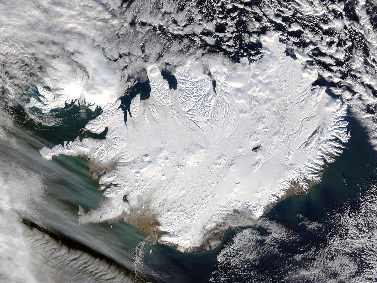
Iceland, dressed in winter white, peaked through a hole in a complex system of clouds in late February, 2015. The Moderate Resolution Imaging Spectroradiometer (MODIS) aboard NASA’s Terra satellite captured this true-color image on February 21 as it passed over the region. Ice and snow covers Iceland almost entirely, except for coastal regions in the southwest and southeast. The extensive, roughly H-shaped area in the southeast section of the island is Vatnajökull, Iceland’s largest glacier. Hidden underneath the ice lies Bardarbunga, a large subglacial stratovolcano. On August 31, 2014 the volcano began an eruption at two fissures to the north of the glacier and deposited a lava field that measured about 131 feet (40 meters) at its thickest points, and covered an area about 33 sq. mi (85 sq. km) by the time the eruption ended on February 27, 2015. The massive lava flow left its mark on Iceland – the cooled lava can be seen as the roughly oval black area to the north of the Vatnajökull glacier. Credit: NASA/GSFC/Jeff Schmaltz/MODIS Land Rapid Response Team <b><a href="http://www.nasa.gov/audience/formedia/features/MP_Photo_Guidelines.html" rel="nofollow">NASA image use policy.</a></b> <b><a href="http://www.nasa.gov/centers/goddard/home/index.html" rel="nofollow">NASA Goddard Space Flight Center</a></b> enables NASA’s mission through four scientific endeavors: Earth Science, Heliophysics, Solar System Exploration, and Astrophysics. Goddard plays a leading role in NASA’s accomplishments by contributing compelling scientific knowledge to advance the Agency’s mission. <b>Follow us on <a href="http://twitter.com/NASAGoddardPix" rel="nofollow">Twitter</a></b> <b>Like us on <a href="http://www.facebook.com/pages/Greenbelt-MD/NASA-Goddard/395013845897?ref=tsd" rel="nofollow">Facebook</a></b> <b>Find us on <a href="http://instagram.com/nasagoddard?vm=grid" rel="nofollow">Instagram</a></b>