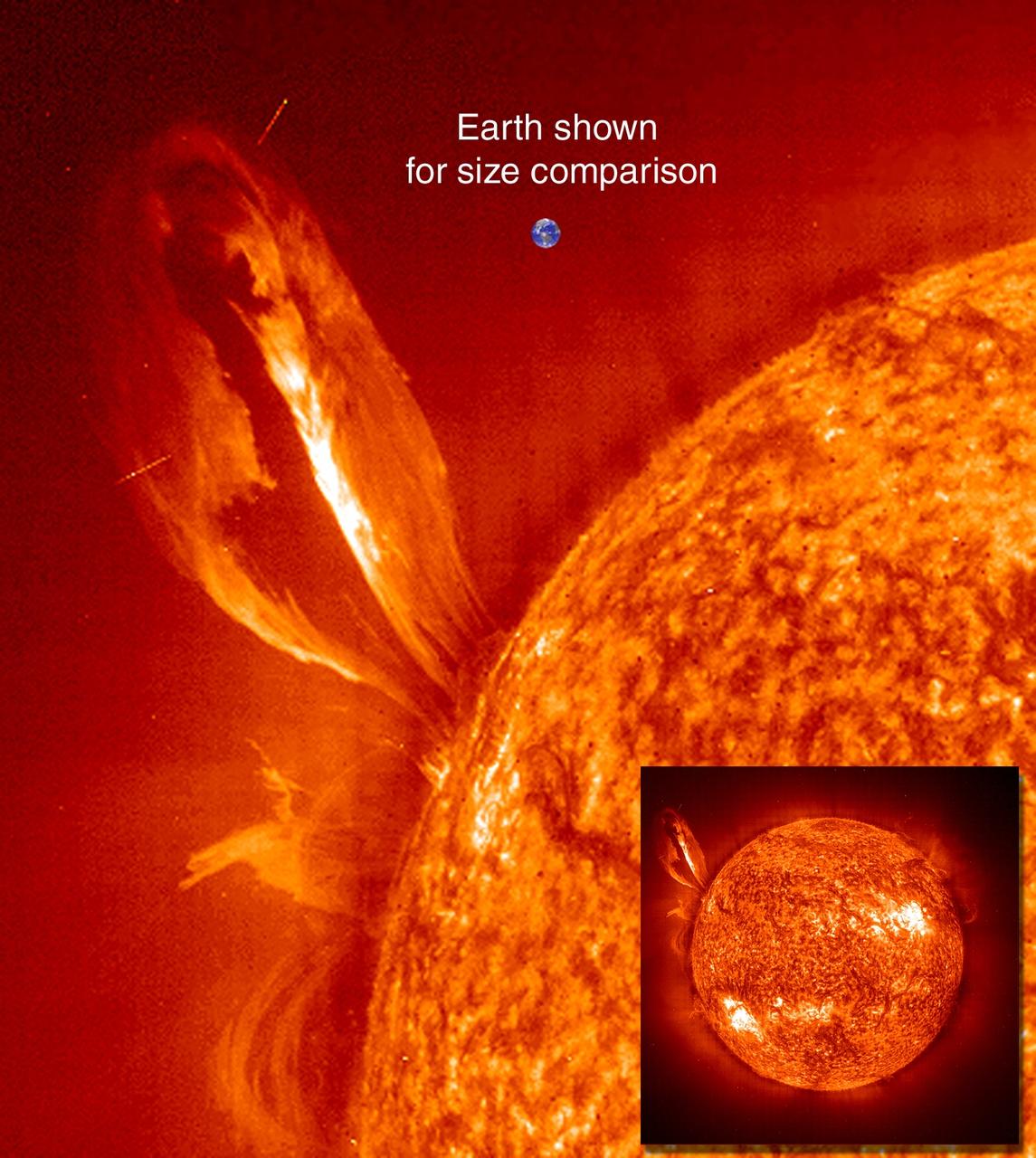
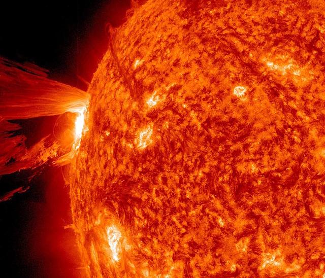
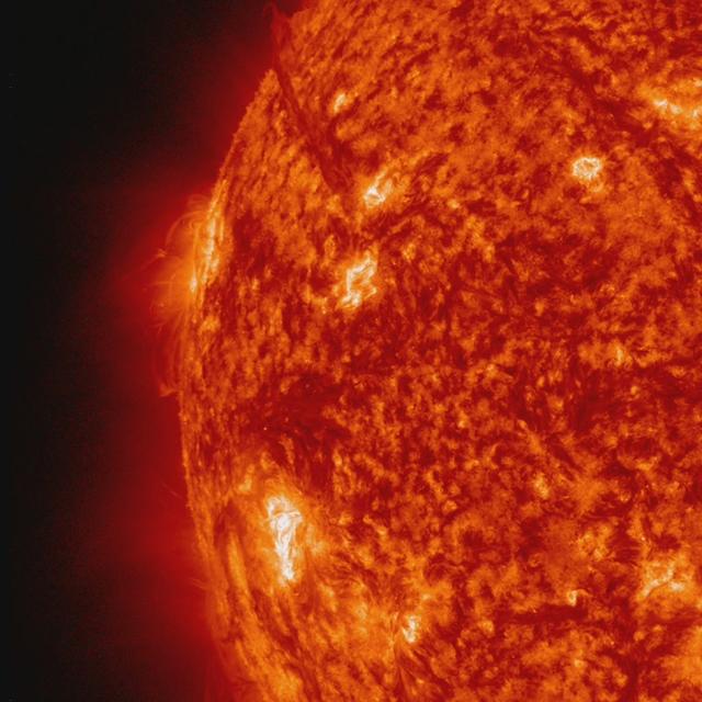
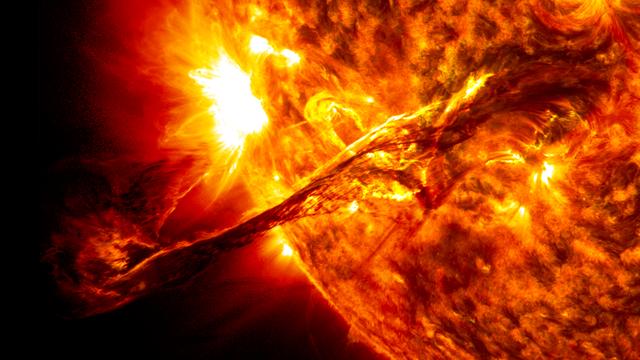
Large, eruptive prominence in He II at 304Å, with an image of the Earth added for size comparison. This prominence from 24 July 1999 is particularly large and looping, extending over 35 Earths out from the Sun. Erupting prominences (when Earthward directed) can affect communications, navigation systems, even power grids, while also producing auroras visible in the night skies. Credit: NASA/GSFC/SOHO/ESA To learn more go to the SOHO website: <a href="http://sohowww.nascom.nasa.gov/home.html" rel="nofollow">sohowww.nascom.nasa.gov/home.html</a> To learn more about NASA's Sun Earth Day go here: <a href="http://sunearthday.nasa.gov/2010/index.php" rel="nofollow">sunearthday.nasa.gov/2010/index.php</a>
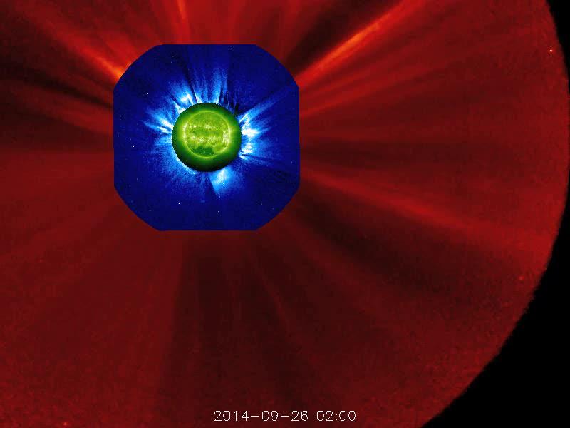
The STEREO (Behind) spacecraft captured this large prominence and corona mass ejection as they erupted into space (Sept. 26, 2014). By combining images from three instruments, scientists can see the eruption itself (in extreme UV light) as well as follow its progression over the period of about 13 hours with its two coronagraphs. Credit: NASA/Goddard/STEREO The STEREO (Behind) spacecraft captured this large prominence and corona mass ejection as they erupted into space (Sept. 26, 2014). By combining images from three instruments, scientists can see the eruption itself (in extreme UV light) as well as follow its progression over the period of about 13 hours with its two coronagraphs.
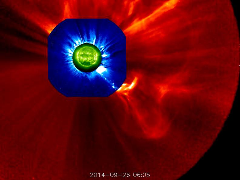
The STEREO (Behind) spacecraft captured this large prominence and corona mass ejection as they erupted into space (Sept. 26, 2014). By combining images from three instruments, scientists can see the eruption itself (in extreme UV light) as well as follow its progression over the period of about 13 hours with its two coronagraphs. Credit: NASA/Goddard/STEREO The STEREO (Behind) spacecraft captured this large prominence and corona mass ejection as they erupted into space (Sept. 26, 2014). By combining images from three instruments, scientists can see the eruption itself (in extreme UV light) as well as follow its progression over the period of about 13 hours with its two coronagraphs.
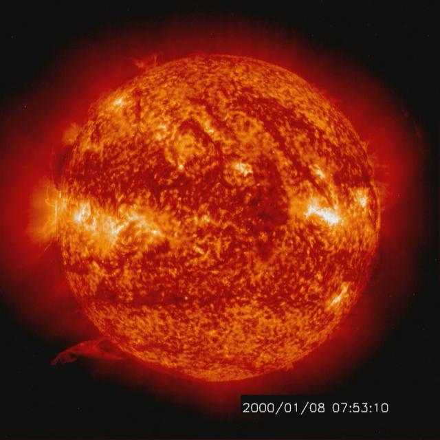
Solar activity and erupting prominences. EIT 304A (Jan. 8-10, 2000) Credit: NASA/GSFC/SOHO/ESA To learn more go to the SOHO website: <a href="http://sohowww.nascom.nasa.gov/home.html" rel="nofollow">sohowww.nascom.nasa.gov/home.html</a> To learn more about NASA's Sun Earth Day go here: <a href="http://sunearthday.nasa.gov/2010/index.php" rel="nofollow">sunearthday.nasa.gov/2010/index.php</a>
An erupting prominence observed by SDO on March 30, 2010. Credit: NASA/GSFC/SDO To read more about this image go to: <a href="http://www.nasa.gov/mission_pages/sdo/news/first-light.html" rel="nofollow">www.nasa.gov/mission_pages/sdo/news/first-light.html</a> <b><a href="http://www.nasa.gov/centers/goddard/home/index.html" rel="nofollow">NASA Goddard Space Flight Center</a></b> is home to the nation's largest organization of combined scientists, engineers and technologists that build spacecraft, instruments and new technology to study the Earth, the sun, our solar system, and the universe.
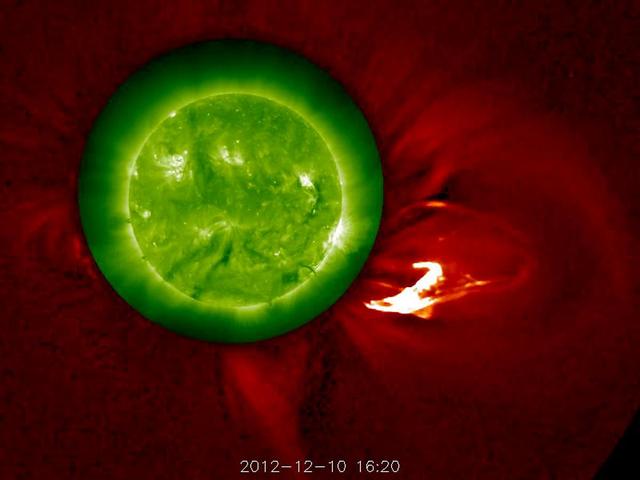
The Sun blows a robust prominence out into space (Dec. 10, 2102). The outer image, from the STEREO-A's COR1 coronagraph, has been changed from green to red to complement the green Sun image, taken in extreme UV light. The movie covers six hours of activity. Kind of Christmassy looking, isn't it? Some of the prominence falls back towards the sun, although the disturbance as a whole continues out into the solar system. Credit: NASA/GSFC/STEREO <b><a href="http://www.nasa.gov/audience/formedia/features/MP_Photo_Guidelines.html" rel="nofollow">NASA image use policy.</a></b> <b><a href="http://www.nasa.gov/centers/goddard/home/index.html" rel="nofollow">NASA Goddard Space Flight Center</a></b> enables NASA’s mission through four scientific endeavors: Earth Science, Heliophysics, Solar System Exploration, and Astrophysics. Goddard plays a leading role in NASA’s accomplishments by contributing compelling scientific knowledge to advance the Agency’s mission. <b>Follow us on <a href="http://twitter.com/NASA_GoddardPix" rel="nofollow">Twitter</a></b> <b>Like us on <a href="http://www.facebook.com/pages/Greenbelt-MD/NASA-Goddard/395013845897?ref=tsd" rel="nofollow">Facebook</a></b> <b>Find us on <a href="http://instagram.com/nasagoddard?vm=grid" rel="nofollow">Instagram</a></b>
NASA's Solar Dynamics Observatory captured this image of the moon crossing in front of its view of the sun on Jan. 30, 2014, at 10:30 a.m. EST in 171 and 304 angstrom light. The two wavelengths are blended together. Credit: NASA/SDO <b><a href="http://www.nasa.gov/audience/formedia/features/MP_Photo_Guidelines.html" rel="nofollow">NASA image use policy.</a></b> <b><a href="http://www.nasa.gov/centers/goddard/home/index.html" rel="nofollow">NASA Goddard Space Flight Center</a></b> enables NASA’s mission through four scientific endeavors: Earth Science, Heliophysics, Solar System Exploration, and Astrophysics. Goddard plays a leading role in NASA’s accomplishments by contributing compelling scientific knowledge to advance the Agency’s mission. <b>Follow us on <a href="http://twitter.com/NASAGoddardPix" rel="nofollow">Twitter</a></b> <b>Like us on <a href="http://www.facebook.com/pages/Greenbelt-MD/NASA-Goddard/395013845897?ref=tsd" rel="nofollow">Facebook</a></b> <b>Find us on <a href="http://instagram.com/nasagoddard?vm=grid" rel="nofollow">Instagram</a></b>

On Oct. 24-25, 2018 a solar prominence rose up above the Sun's surface, twisted and spun around, then became elongated and broke away. Prominences are unstable clouds of cooler plasma suspended above the Sun by strong magnetic forces. They often fall apart after a few days. Although tiny on the scale of the Sun, this prominence stretched out about ten times the diameter of Earth (see inset). Images were taken in a wavelength of extreme ultraviolet light. Animations are available at https://photojournal.jpl.nasa.gov/catalog/PIA18140
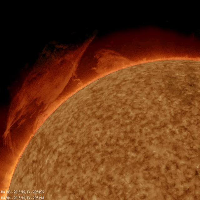
A mass of plasma gathered itself into a twisting mass, spun around for a bit, then rose up and broke apart over a 10-hour period Oct. 13, 2015 as observed by NASA Solar Dynamics Observatory. The image and video were produced with a combination of two wavelengths of extreme ultraviolet light. Prominences are unstable clouds of gas tethered above the surface of the Sun by magnetic forces. Much of the jittering and odd jumping motions above the surface were artifacts caused by brightening and contrast changes used to bring out the detail and structure of the prominence. http://photojournal.jpl.nasa.gov/catalog/PIA20008

Some of the prominences that float like lazy clouds above the solar surface suddenly erupt and break away from the Sun in cataclysmic action. The trigger of this coronal transient, like many others seen by Skylab's coronagraph, was an eruptive prominence that surged outward from the limb of the Sun, ejecting matter that disturbed the outer corona. This image is of the surge in action in ultraviolet light of ionized helium. Simultaneous observations like this made possible an almost immediate understanding of the new-found cosmic phenomenon. The elbow prominence was accidentally photographed by Astronaut Garriott (Skylab-3) while observing a small flare near the limb of the Sun beneath the mighty arch on August 9, 1973.

This spectacular view is a color-enhanced ultraviolet exposure of a colossal eruption, photographed during the Skylab-4 mission by the Apollo Telescope Mount facility on December 19, 1973. This giant prominence, one of the mightiest in 25 years, sparned a third of a million miles into space, roughly the distance between Earth and the Moon.
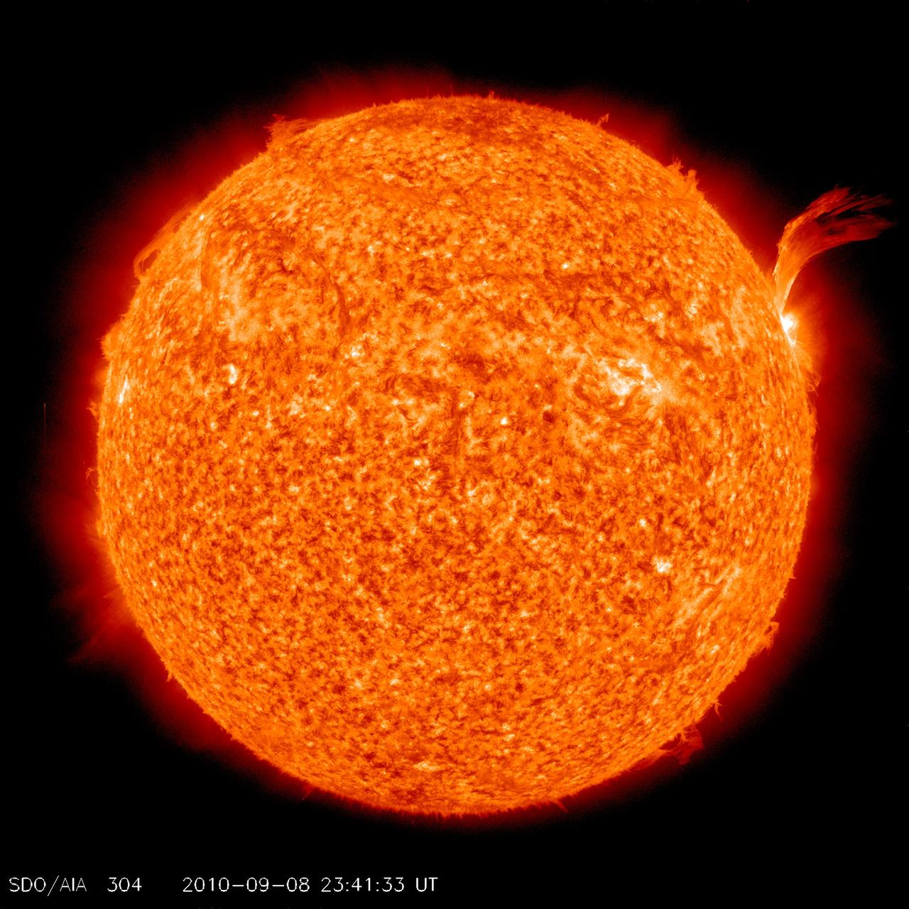
NASA image release Sept 9, 2010 Just as sunspot 1105 was turning away from Earth on Sept. 8, the active region erupted, producing a solar flare and a fantastic prominence. The eruption also hurled a bright coronal mass ejection into space. The eruption was not directed toward any planets. To see a detail go here: <a href="http://www.flickr.com/photos/gsfc/4974263471/">www.flickr.com/photos/gsfc/4974263471/</a> View the video here: <a href="http://www.flickr.com/photos/gsfc/4974878090">www.flickr.com/photos/gsfc/4974878090</a> This is a snapshot of the prominence. Credit: NASA/SDO <b><a href="http://www.nasa.gov/centers/goddard/home/index.html" rel="nofollow">NASA Goddard Space Flight Center</a></b> is home to the nation's largest organization of combined scientists, engineers and technologists that build spacecraft, instruments and new technology to study the Earth, the sun, our solar system, and the universe. <b>Follow us on <a href="http://twitter.com/NASA_GoddardPix" rel="nofollow">Twitter</a></b> <b>Join us on <a href="http://www.facebook.com/pages/Greenbelt-MD/NASA-Goddard/395013845897?ref=tsd" rel="nofollow">Facebook</a></b>
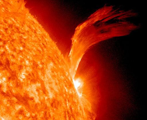
NASA image release Sept 9, 2010 Just as sunspot 1105 was turning away from Earth on Sept. 8, the active region erupted, producing a solar flare and a fantastic prominence. The eruption also hurled a bright coronal mass ejection into space. The eruption was not directed toward any planets. View the video here: <a href="http://www.flickr.com/photos/gsfc/4974878090">www.flickr.com/photos/gsfc/4974878090</a> To see a full disk view go here: <a href="http://www.flickr.com/photos/gsfc/4975115754/">www.flickr.com/photos/gsfc/4975115754/</a> This is a snapshot of the prominence. Credit: NASA/SDO <b><a href="http://www.nasa.gov/centers/goddard/home/index.html" rel="nofollow">NASA Goddard Space Flight Center</a></b> is home to the nation's largest organization of combined scientists, engineers and technologists that build spacecraft, instruments and new technology to study the Earth, the sun, our solar system, and the universe. <b>Follow us on <a href="http://twitter.com/NASA_GoddardPix" rel="nofollow">Twitter</a></b> <b>Join us on <a href="http://www.facebook.com/pages/Greenbelt-MD/NASA-Goddard/395013845897?ref=tsd" rel="nofollow">Facebook</a></b>
art002e012129 (April 6, 2026) - The lower half of the Moon hangs suspended in time in this photograph from the Artemis II crew during the lunar flyby observation period. In the upper center of the photo, the Orientale basin is the prominent feature, with a black patch of ancient lava in the center that punched through the Moon’s crust in an eruption billions of years ago. Credit: NASA
NASA image acquired May 30, 2011 On May 30, 2011, the STEREO Behind spacecraft caught a prominence in the process of leaping from one part of the Sun to another. In this movie: <a href="http://www.flickr.com/photos/gsfc/5804079351">www.flickr.com/photos/gsfc/5804079351</a> combining images from the EUVI and COR1 telescopes, the prominence is first seen erupting by EUVI in images taken in the Helium II emission line at 304 Angstroms. At higher elevations, it is seen in white light by the COR1 telescope. In the COR1 images, the prominence pauses. Some of the prominence material drains back down, but most of it is deflected to the north, and ends up raining down on a completely different part of the Sun, far from where it started. This is very unusual behavior for an erupting prominence, and this event is sure to be carefully studied by scientists. Some out-of-focus dust particles just in front of the COR1 telescope are briefly visible toward the end of the movie. Credit: NASA/GSFC/STEREO <b><a href="http://www.nasa.gov/centers/goddard/home/index.html" rel="nofollow">NASA Goddard Space Flight Center</a></b> enables NASA’s mission through four scientific endeavors: Earth Science, Heliophysics, Solar System Exploration, and Astrophysics. Goddard plays a leading role in NASA’s accomplishments by contributing compelling scientific knowledge to advance the Agency’s mission. <b>Follow us on <a href="http://twitter.com/NASA_GoddardPix" rel="nofollow">Twitter</a></b> <b>Join us on <a href="http://www.facebook.com/pages/Greenbelt-MD/NASA-Goddard/395013845897?ref=tsd" rel="nofollow">Facebook</a></b> <b>Find us on <a href="http://instagr.am/p/E_05l/" rel="nofollow">Instagram</a></b>
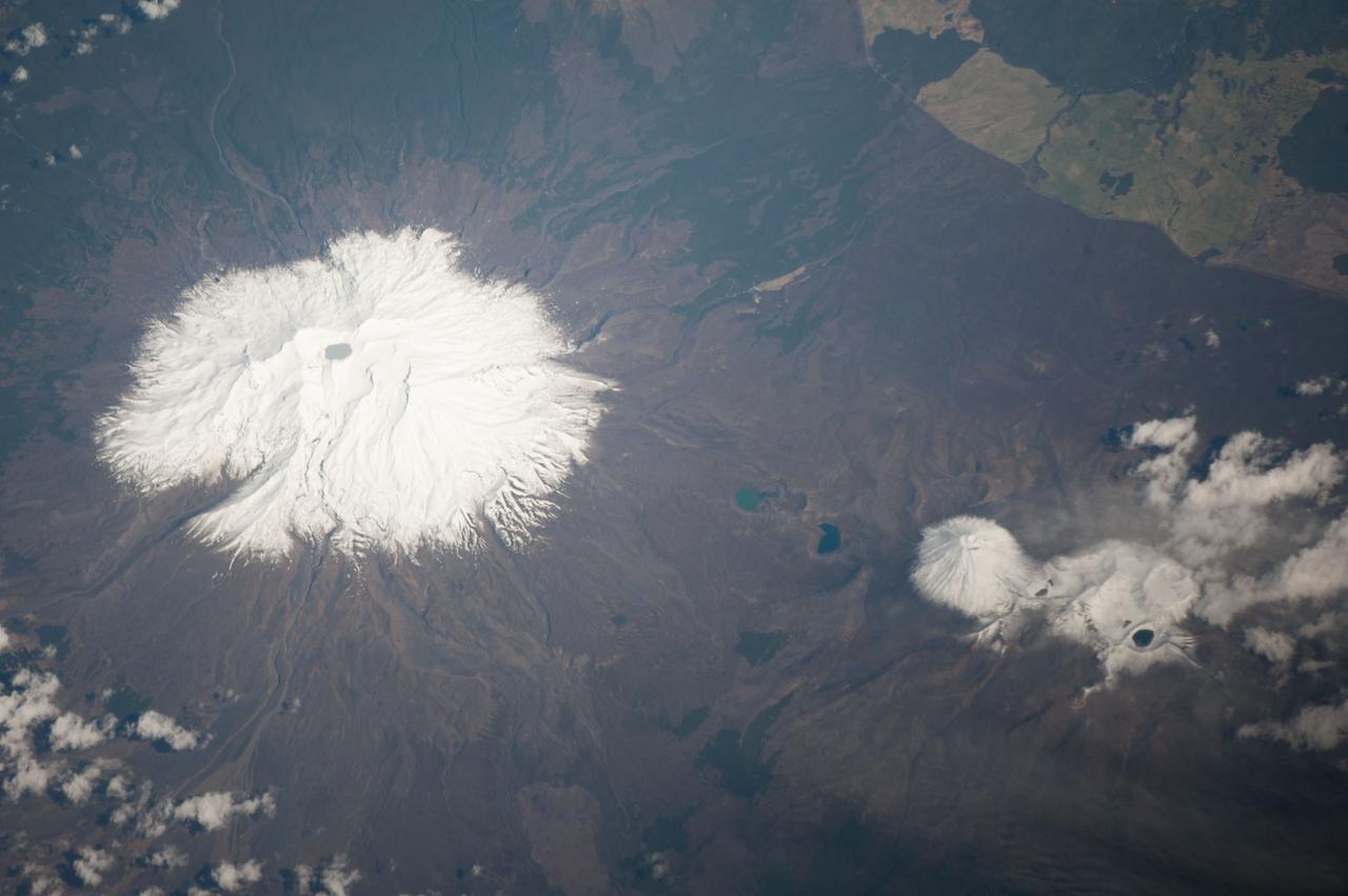
ISS037-E-005089 (30 Sept. 2013) --- Ruapehu volcano and Tongariro volcanic complex in New Zealand are featured in this image photographed by an Expedition 37 crew member on the International Space Station. Mount Ruapehu is one of several volcanic centers on the North Island of New Zealand, but is the largest and historically most active. The 2,797-meter elevation volcano is also the highest mountain on North Island and is covered with snow on its upper slopes. Scientists believe while there are three summit craters that have been active during the last 10,000 years, South Crater is the only historically active one. This vent is currently filled with a lake (Crater Lake), visible at left; eruptions from the vent, mixed with water from the lake can lead to the formation of lahars – destructive gravity flows of mixed fluid and volcanic debris that form a hazard to ski areas on the upper slopes and lower river valleys. The most recent significant eruption of Ruapehu took place in 2007 and formed both an eruption plume and lahars. The volcano is surrounded by a 100-cubic-kilometer ring plain of volcaniclastic debris that appears dark grey in the image, whereas vegetated areas appear light to dark green. Located to the northeast of the Ruapehu volcanic structure, the Tongariro volcanic complex (lower right) is currently in an active eruptive phase – the previous eruptive phase ended in 1897. Explosive eruptions occurred in 2012, which have been followed by steam and gas plumes observed almost daily. According to scientists, the volcanic complex contains multiple cones constructed over the past 275,000 years. The most prominent of these, Mount Ngauruhoe, last erupted in 1975. Like Ruapehu, the upper slopes of both Ngauruhoe and the upper peaks of Tongariro are snow-covered. Scattered cloud cover is also visible near Tongariro at lower right.
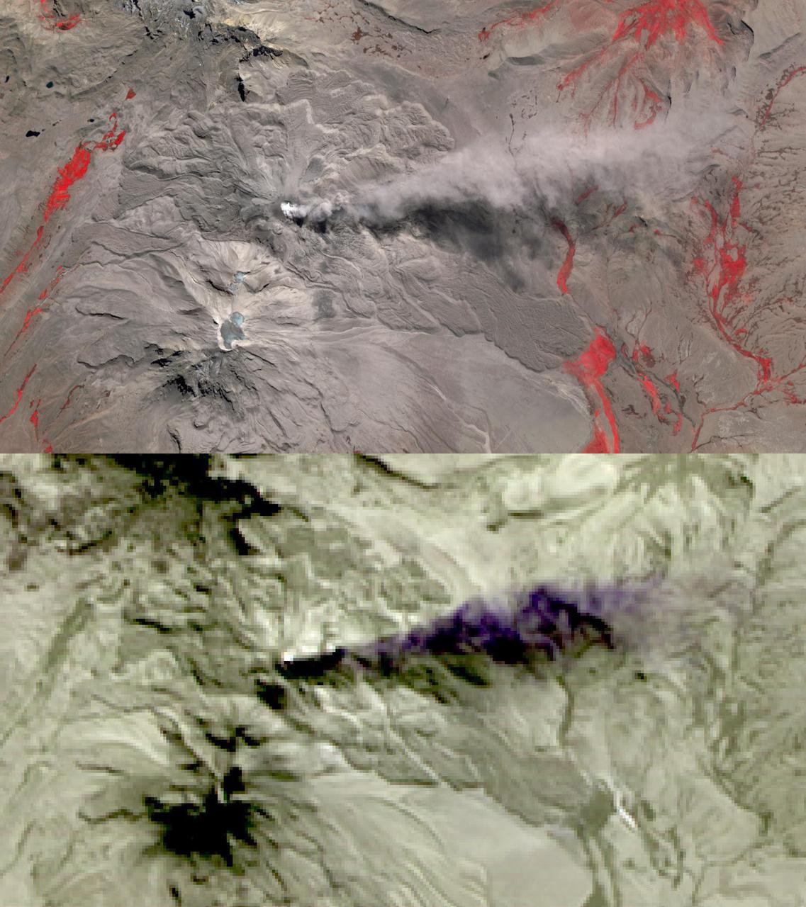
In this image of Peru's Sabancaya stratovolcano, acquired May 13, 2020, the years-long eruption continues. In the top image, Sabancaya has a bright white cloud in its caldera. The greyish cloud to the east is an ash plume. The Ampato volcano, with its prominent summit caldera, is to the south. The red areas are vegetation. The lower thermal infrared composite image shows the plume in purple, indicating that it is dominantly composed of ash and water vapor. A bright hotspot can be seen in the summit caldera of Sabancaya. The images cover an area of 13.5 by 24 kilometers, and are located at 15.8 degrees south, 71.9 degrees west. https://photojournal.jpl.nasa.gov/catalog/PIA24866
Italy's Mount Etna and the Aeolian Islands are the focus of this perspective view made from an Advanced Spaceborne Thermal and Emission Radiometer (ASTER) image from NASA's Terra spacecraft overlaid on Shuttle Radar Topography Mission (SRTM) topography. The image is looking south with the islands of Lipari and Vulcano in the foreground and Etna with its dark lava flows on the skyline. Vulcano also hosts an active volcano, the cone of which is prominent. In late October 2002, Etna erupted again, sending lava flows down the north and south sides of the volcano. The north flows are near the center of this view, but the ASTER image is from before the eruption. In addition to the terrestrial applications of these data for understanding active volcanoes and hazards associated with them such as lava flows and explosive eruptions, geologists studying Mars find these data useful as an analog to martian landforms and geologic processes. In late September 2002, a field conference with the theme of Terrestrial Analogs to Mars focused on Mount Etna allowing Mars geologists to see in person the types of features they can only sample remotely. http://photojournal.jpl.nasa.gov/catalog/PIA03370
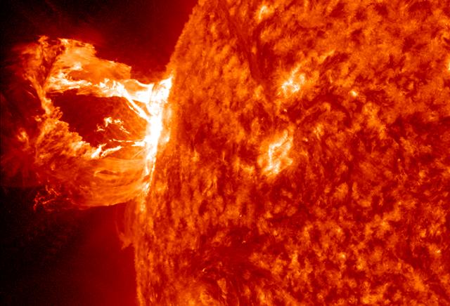
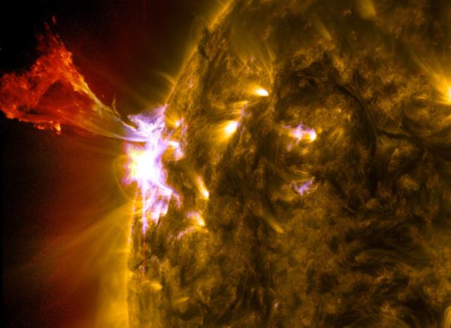
A beautiful prominence eruption shot off the east limb (left side) of the sun on Monday, April 16, 2012. Such eruptions are often associated with solar flares, and in this case an M1 class (medium-sized) flare did occur at the same time, though it was not aimed toward Earth. This event, which is still in progress, was seen by NASA’s SDO satellite. Credit: NASA/GSFC/SDO <b><a href="http://www.nasa.gov/audience/formedia/features/MP_Photo_Guidelines.html" rel="nofollow">NASA image use policy.</a></b> <b><a href="http://www.nasa.gov/centers/goddard/home/index.html" rel="nofollow">NASA Goddard Space Flight Center</a></b> enables NASA’s mission through four scientific endeavors: Earth Science, Heliophysics, Solar System Exploration, and Astrophysics. Goddard plays a leading role in NASA’s accomplishments by contributing compelling scientific knowledge to advance the Agency’s mission. <b>Follow us on <a href="http://twitter.com/NASA_GoddardPix" rel="nofollow">Twitter</a></b> <b>Like us on <a href="http://www.facebook.com/pages/Greenbelt-MD/NASA-Goddard/395013845897?ref=tsd" rel="nofollow">Facebook</a></b> <b>Find us on <a href="http://instagrid.me/nasagoddard/?vm=grid" rel="nofollow">Instagram</a></b>
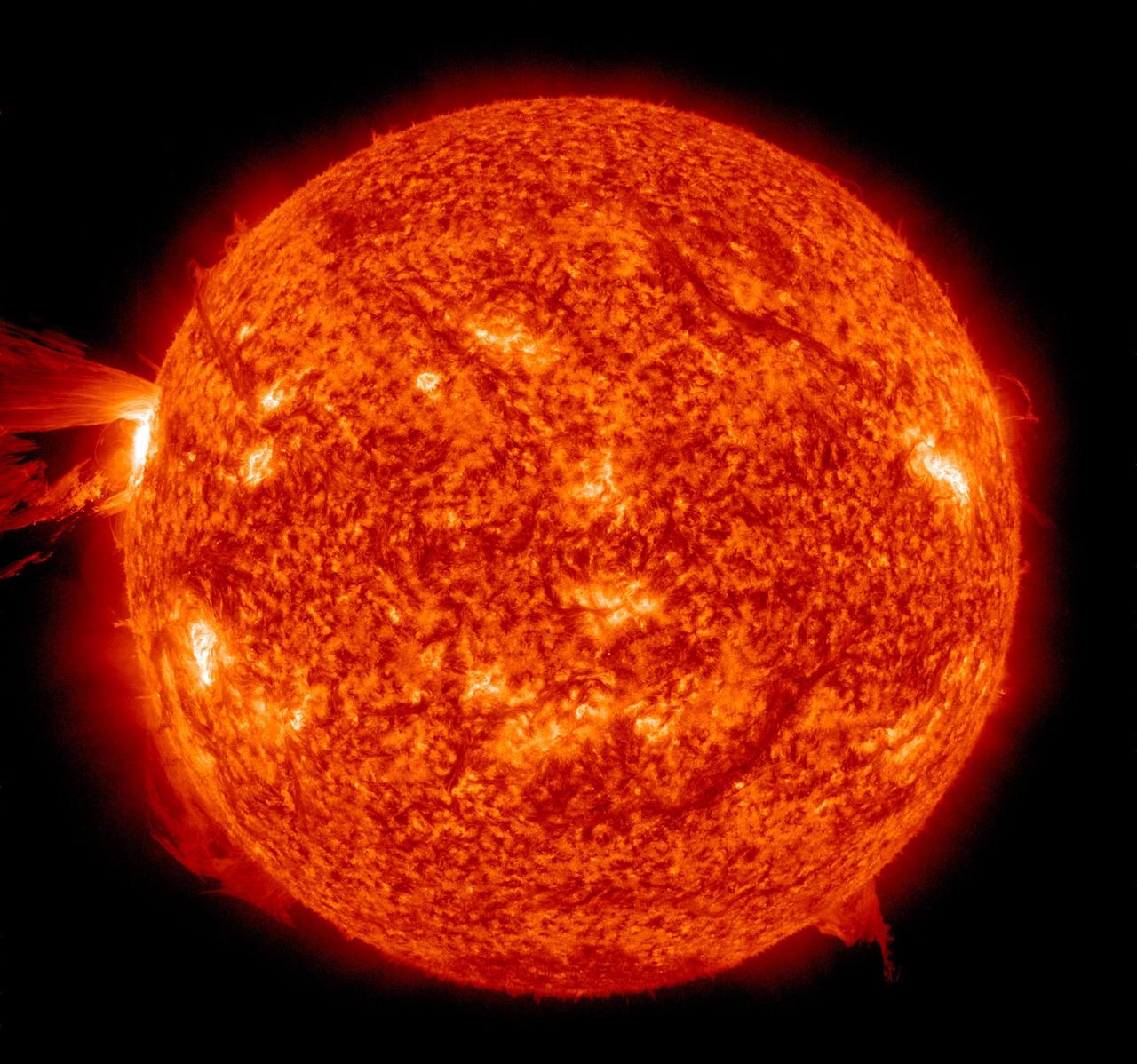
A beautiful prominence eruption shot off the east limb (left side) of the sun on Monday, April 16, 2012. Such eruptions are often associated with solar flares, and in this case an M1 class (medium-sized) flare did occur at the same time, though it was not aimed toward Earth. This event, which is still in progress, was seen by NASA’s SDO satellite. Credit: NASA/GSFC/SDO <b><a href="http://www.nasa.gov/audience/formedia/features/MP_Photo_Guidelines.html" rel="nofollow">NASA image use policy.</a></b> <b><a href="http://www.nasa.gov/centers/goddard/home/index.html" rel="nofollow">NASA Goddard Space Flight Center</a></b> enables NASA’s mission through four scientific endeavors: Earth Science, Heliophysics, Solar System Exploration, and Astrophysics. Goddard plays a leading role in NASA’s accomplishments by contributing compelling scientific knowledge to advance the Agency’s mission. <b>Follow us on <a href="http://twitter.com/NASA_GoddardPix" rel="nofollow">Twitter</a></b> <b>Like us on <a href="http://www.facebook.com/pages/Greenbelt-MD/NASA-Goddard/395013845897?ref=tsd" rel="nofollow">Facebook</a></b> <b>Find us on <a href="http://instagrid.me/nasagoddard/?vm=grid" rel="nofollow">Instagram</a></b>
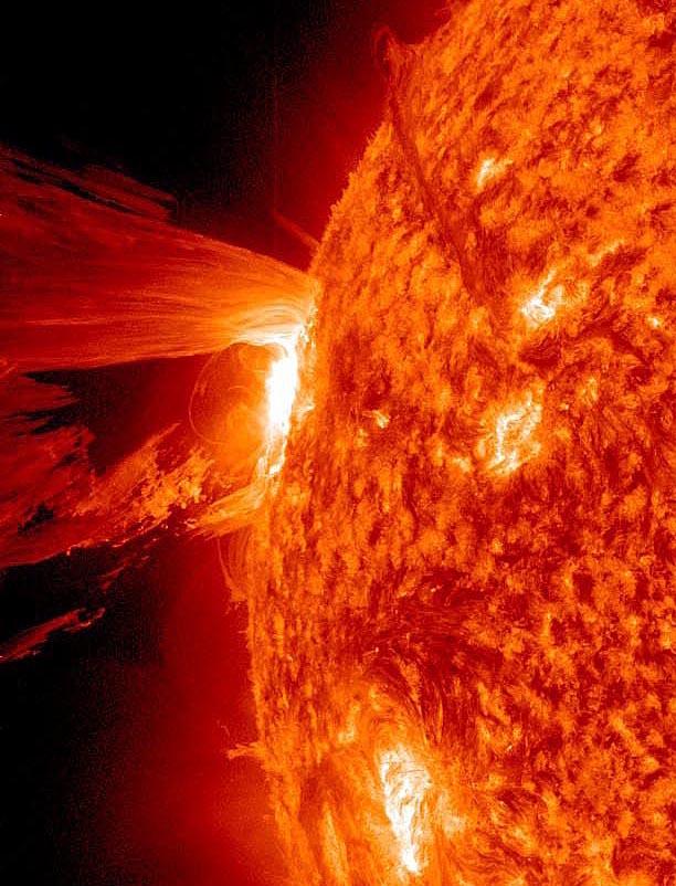
A beautiful prominence eruption shot off the east limb (left side) of the sun on Monday, April 16, 2012. Such eruptions are often associated with solar flares, and in this case an M1 class (medium-sized) flare did occur at the same time, though it was not aimed toward Earth. This event, which is still in progress, was seen by NASA’s SDO satellite. <b>View a video of this event here: <a href="http://www.flickr.com/photos/gsfc/7084820027">www.flickr.com/photos/gsfc/7084820027</a></b> Credit: NASA/GSFC/SDO <b><a href="http://www.nasa.gov/audience/formedia/features/MP_Photo_Guidelines.html" rel="nofollow">NASA image use policy.</a></b> <b><a href="http://www.nasa.gov/centers/goddard/home/index.html" rel="nofollow">NASA Goddard Space Flight Center</a></b> enables NASA’s mission through four scientific endeavors: Earth Science, Heliophysics, Solar System Exploration, and Astrophysics. Goddard plays a leading role in NASA’s accomplishments by contributing compelling scientific knowledge to advance the Agency’s mission. <b>Follow us on <a href="http://twitter.com/NASA_GoddardPix" rel="nofollow">Twitter</a></b> <b>Like us on <a href="http://www.facebook.com/pages/Greenbelt-MD/NASA-Goddard/395013845897?ref=tsd" rel="nofollow">Facebook</a></b> <b>Find us on <a href="http://instagrid.me/nasagoddard/?vm=grid" rel="nofollow">Instagram</a></b>
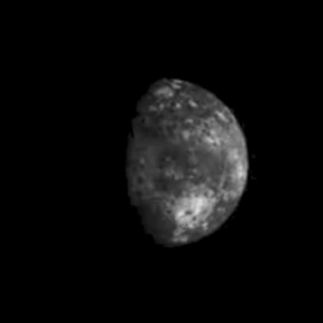
Range : 40,000 km (24,8000 mi.) This picture of Triton is a mosaic of the highest resolution images taken by Voyager 2. The mosaic is superimposed on the lower-resolution mapping images taken about 2 hours earlier in order to fill in gaps between high-resolution images. The smallest features that can be seen on the images are about 0.8 km (0.5 mi.) across. The terminator (line separation day and night) is at the top of the picture and is centered at about 30 degrees north latitude and 330 degrees longitude. These highest-resolution images were targeted for the terminator region to show details of the topography by the shadows it casts. Near the center of the picture is a depression filled with smooth plains that are probably ices which were once erupted in a fluid state. The depth of the depression is about 300 meters (900 feet) and the prominent fresh impact crater on its floor is about 20 km (12 mi.) in diameter and about 1 km (0.6 mi.) deep. On the right is a elongate crater with adjacent dark deposits about it. This feature may be an explosive eruption vent formed by gaps within the ice. The linear structure on the lest is probably a fracture along which fresh ice has been extruded.
A beautiful prominence eruption shot off the east limb (left side) of the sun on Monday, April 16, 2012. Such eruptions are often associated with solar flares, and in this case an M1 class (medium-sized) flare did occur at the same time, though it was not aimed toward Earth. This event, which is still in progress, was seen by NASA’s SDO satellite. <b>View a video of this event here: <a href="http://www.flickr.com/photos/gsfc/7084820027">www.flickr.com/photos/gsfc/7084820027</a></b> Credit: NASA/GSFC/SDO <b><a href="http://www.nasa.gov/audience/formedia/features/MP_Photo_Guidelines.html" rel="nofollow">NASA image use policy.</a></b> <b><a href="http://www.nasa.gov/centers/goddard/home/index.html" rel="nofollow">NASA Goddard Space Flight Center</a></b> enables NASA’s mission through four scientific endeavors: Earth Science, Heliophysics, Solar System Exploration, and Astrophysics. Goddard plays a leading role in NASA’s accomplishments by contributing compelling scientific knowledge to advance the Agency’s mission. <b>Follow us on <a href="http://twitter.com/NASA_GoddardPix" rel="nofollow">Twitter</a></b> <b>Like us on <a href="http://www.facebook.com/pages/Greenbelt-MD/NASA-Goddard/395013845897?ref=tsd" rel="nofollow">Facebook</a></b> <b>Find us on <a href="http://instagrid.me/nasagoddard/?vm=grid" rel="nofollow">Instagram</a></b>
A beautiful prominence eruption shot off the east limb (left side) of the sun on Monday, April 16, 2012. Such eruptions are often associated with solar flares, and in this case an M1 class (medium-sized) flare did occur at the same time, though it was not aimed toward Earth. This event, which is still in progress, was seen by NASA’s SDO satellite. Credit: NASA/GSFC/SDO <b><a href="http://www.nasa.gov/audience/formedia/features/MP_Photo_Guidelines.html" rel="nofollow">NASA image use policy.</a></b> <b><a href="http://www.nasa.gov/centers/goddard/home/index.html" rel="nofollow">NASA Goddard Space Flight Center</a></b> enables NASA’s mission through four scientific endeavors: Earth Science, Heliophysics, Solar System Exploration, and Astrophysics. Goddard plays a leading role in NASA’s accomplishments by contributing compelling scientific knowledge to advance the Agency’s mission. <b>Follow us on <a href="http://twitter.com/NASA_GoddardPix" rel="nofollow">Twitter</a></b> <b>Like us on <a href="http://www.facebook.com/pages/Greenbelt-MD/NASA-Goddard/395013845897?ref=tsd" rel="nofollow">Facebook</a></b> <b>Find us on <a href="http://instagrid.me/nasagoddard/?vm=grid" rel="nofollow">Instagram</a></b>
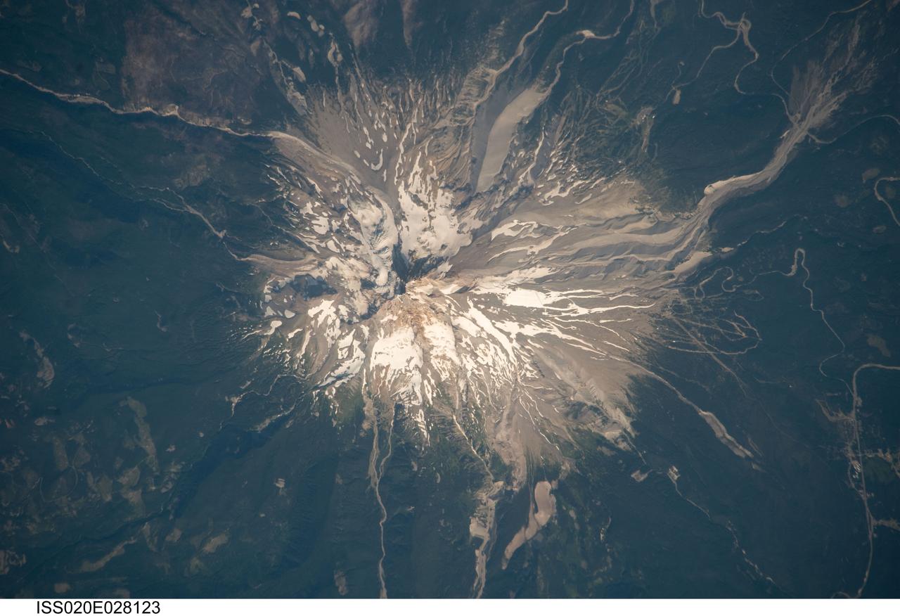
ISS020-E-028123 (5 Aug. 2009) --- Mount Hood, Oregon is featured in this image photographed by an Expedition 20 crew member on the International Space Station. Mount Hood is located within the Cascade Range of the western United States, and is the highest peak (3,426 m) in Oregon. The Cascade Range is characterized by a line of volcanoes associated with a slab of oceanic crust that is subducting, or descending underneath, the westward moving continental crust of North America. Magma generated by the subduction process rises upward through the crust and feeds a line of active volcanoes that extends from northern California in the United States to southern British Columbia in Canada. While hot springs and steam vents are still active on Mount Hood, the last eruption from the volcano occurred in 1866. The volcano is considered dormant, but still actively monitored. Separate phases of eruptive activity produced pyroclastic flows and lahars ? mudflows ? that carried erupted materials down all of the major rivers draining the volcano. Gray volcanic deposits extend southwards along the banks of the White River (upper right), and form several prominent ridges along the southeast to southwest flanks of the volcano. The deposits contrast sharply with the green vegetated lower flanks of the volcano. The Mount Hood stratovolcano ? a typically cone-shaped volcanic structure formed by interlayered lava flows and explosive eruption deposits ? hosts twelve mapped glaciers along its upper flanks (center). Like other glaciers in the Pacific Northwest, the Hood glaciers have been receding due to global warming, and have lost an estimated 61 percent of their volume over the past century. The predicted loss of glacial meltwater under future warming scenarios will have significant effects on regional hydrology and water supplies.

STS084-707-013 (15-24 May 1997) --- As photographed from the Earth-orbiting Space Shuttle Atlantis, this 70mm scene provides a modern view from space of a region rich in ancient history. The Minoan civilization thrived on Crete (western end of the island is visible on the left side of the image) from 3000 BC to about 1100 BC. It is believed by some historians that the eruption of the volcanic island of Thera (the "C" shaped island facing Crete) and possible tsunami helped to bring about the end of the Minoan civilization. The next great civilization to emerge was that of the Greeks. One of the most prominent city-states was Athens which can be seen as a light colored area on an elongated piece of land at center of view (near the clouds). The Aegean Sea separates Greece from Asia Minor (Turkey) in the foreground.
S74-23458 (19 Dec. 1973) --- This photograph of the sun, taken on Dec. 19, 1973, during the third and final manned Skylab mission (Skylab 4), shows one of the most spectacular solar flares ever recorded, spanning more than 588,000 kilometers (365,000 miles) across the solar surface. The last picture, taken some 17 hours earlier, showed this feature as a large quiescent prominence on the eastern side of the sun. The flare gives the distinct impression of a twisted sheet of gas in the process of unwinding itself. Skylab photographs such quiescent features erupt from the sun. In this photograph the solar poles are distinguished by a relative absence of supergranulation network, and a much darker tone than the central portions of the disk. Several active regions are seen on the eastern side of the disk. The photograph was taken in the light of ionized helium by the extreme ultraviolet spectroheliograph instrument of the United States Naval Research Laboratory. Photo credit: NASA
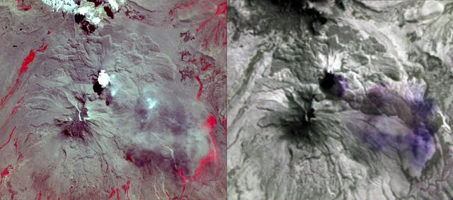
NASA's Advanced Spaceborne Thermal Emission and Reflection Radiometer (ASTER) acquired this image of Peru's Sabancaya stratovolcano on April 10, 2019. Sabancaya has been erupting regularly for several months, sending ash plumes high into the air. At the time this image was taken, the plume reached an altitude of 9100 meters (9950 yards) and was moving southeastward. In the left image, Sabancaya is under the bright round white cloud. The greyish clouds to the southeast are ash plumes. The Ampato volcano, with its prominent summit caldera, is to the south. The red areas are vegetation. The right thermal image shows the plume in purple, indicating that it is dominantly composed of sulfur dioxide gas. A bright hotspot can be seen directly north of the black (cold) cloud over Sabancaya. The image covers an area of 19.5 by 17.2 kilometers (12 miles by 11 miles), and is located at 15.8 degrees south, 71.9 degrees west. https://photojournal.jpl.nasa.gov/catalog/PIA23143
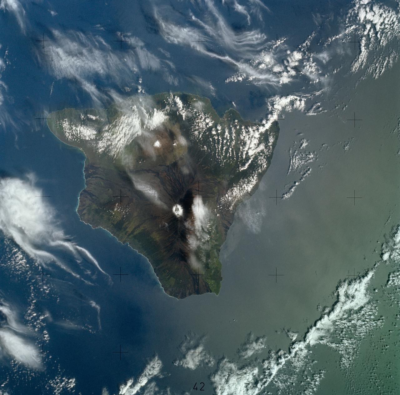
SL4-139-3997 (8 Jan. 1974) --- A vertical view of the Island of Hawaii, State of Hawaii, as photographed from the Skylab space station in Earth orbit by a Skylab 4 crewman. The camera used was a hand-held Hasselblad camera, with SO-368 medium-speed Ektachrome film. This photograph, taken on Jan. 8, 1974, is very useful in studies of volcanic areas. Prominent volcanic features such as the summit caldera on Mauna Loa, the extinct volcano Mauna Kea, the Kilauea caldera, and the pit crater at Halo mau mau within the caldera are easily identified. (Kilauea was undergoing frequent eruption during the mission). Detailed features such as the extent and delineation of historic lava flows on Mauna Loa can be determined and are important parameters in volcanic studies. Photo credit: NASA
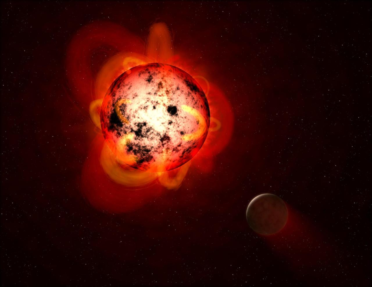
This illustration shows a red dwarf star orbited by a hypothetical exoplanet. Red dwarfs tend to be magnetically active, displaying gigantic arcing prominences and a wealth of dark sunspots. Red dwarfs also erupt with intense flares that could strip a nearby planet's atmosphere over time, or make the surface inhospitable to life as we know it. By mining data from the Galaxy Evolution Explorer (GALEX) spacecraft, a team of astronomers identified dozens of flares at a range of durations and strengths. The team measured events with less total energy than many previously detected flares from red dwarfs. This is important because, although individually less energetic and therefore less hostile to life, smaller flares might be much more frequent and add up over time to produce a cumulative effect on an orbiting planet. https://photojournal.jpl.nasa.gov/catalog/PIA21473
On Aug. 31, 2012, a giant prominence on the sun erupted, sending out particles and a shock wave that traveled near Earth. This event may have been one of the causes of a third radiation belt that appeared around Earth a few days later, a phenomenon that was observed for the very first time by the newly-launched Van Allen Probes. This image of the prominence before it erupted was captured by NASA's Solar Dynamics Observatory (SDO). Credit: NASA/SDO/AIA/Goddard Space Flight Center To read more go to: <a href="http://www.nasa.gov/mission_pages/rbsp/news/third-belt.html" rel="nofollow">www.nasa.gov/mission_pages/rbsp/news/third-belt.html</a> <b><a href="http://www.nasa.gov/audience/formedia/features/MP_Photo_Guidelines.html" rel="nofollow">NASA image use policy.</a></b> <b><a href="http://www.nasa.gov/centers/goddard/home/index.html" rel="nofollow">NASA Goddard Space Flight Center</a></b> enables NASA’s mission through four scientific endeavors: Earth Science, Heliophysics, Solar System Exploration, and Astrophysics. Goddard plays a leading role in NASA’s accomplishments by contributing compelling scientific knowledge to advance the Agency’s mission. <b>Follow us on <a href="http://twitter.com/NASA_GoddardPix" rel="nofollow">Twitter</a></b> <b>Like us on <a href="http://www.facebook.com/pages/Greenbelt-MD/NASA-Goddard/395013845897?ref=tsd" rel="nofollow">Facebook</a></b> <b>Find us on <a href="http://instagram.com/nasagoddard?vm=grid" rel="nofollow">Instagram</a></b>
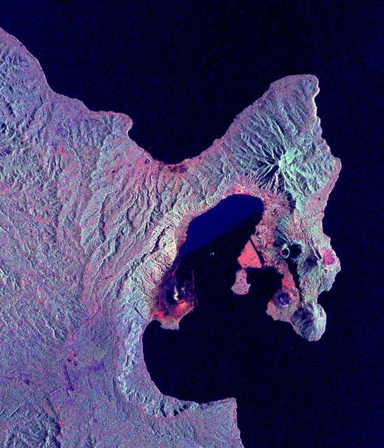
This is a radar image of the Rabaul volcano on the island of New Britain, Papua, New Guinea taken almost a month after its September 19, 1994, eruption that killed five people and covered the town of Rabaul and nearby villages with up to 75 centimeters (30 inches) of ash. More than 53,000 people have been displaced by the eruption. The image was acquired by the Spaceborne Imaging Radar-C/X-band Synthetic Aperture Radar (SIR-C/X-SAR) aboard the space shuttle Endeavour on its 173rd orbit on October 11, 1994. This image is centered at 4.2 degrees south latitude and 152.2 degrees east longitude in the southwest Pacific Ocean. The area shown is approximately 21 kilometers by 25 kilometers (13 miles by 15.5 miles). North is toward the upper right. The colors in this image were obtained using the following radar channels: red represents the L-band (horizontally transmitted and received); green represents the L-band (horizontally transmitted and vertically received); blue represents the C-band (horizontally transmitted and vertically received). Most of the Rabaul volcano is underwater and the caldera (crater) creates Blanche Bay, the semi-circular body of water that occupies most of the center of the image. Volcanic vents within the caldera are visible in the image and include Vulcan, on a peninsula on the west side of the bay, and Rabalanakaia and Tavurvur (the circular purple feature near the mouth of the bay) on the east side. Both Vulcan and Tavurvur were active during the 1994 eruption. Ash deposits appear red-orange on the image, and are most prominent on the south flanks of Vulcan and north and northwest of Tavurvur. A faint blue patch in the water in the center of the image is a large raft of floating pumice fragments that were ejected from Vulcan during the eruption and clog the inner bay. Visible on the east side of the bay are the grid-like patterns of the streets of Rabaul and an airstrip, which appears as a dark northwest-trending band at the right-center of the image. Ashfall and subsequent rains caused the collapse of most buildings in the town of Rabaul. Mudflows and flooding continue to pose serious threats to the town and surrounding villages. Volcanologists and local authorities expect to use data such as this radar image to assist them in identifying the mechanisms of the eruption and future hazardous conditions that may be associated with the vigorously active volcano. http://photojournal.jpl.nasa.gov/catalog/PIA01767

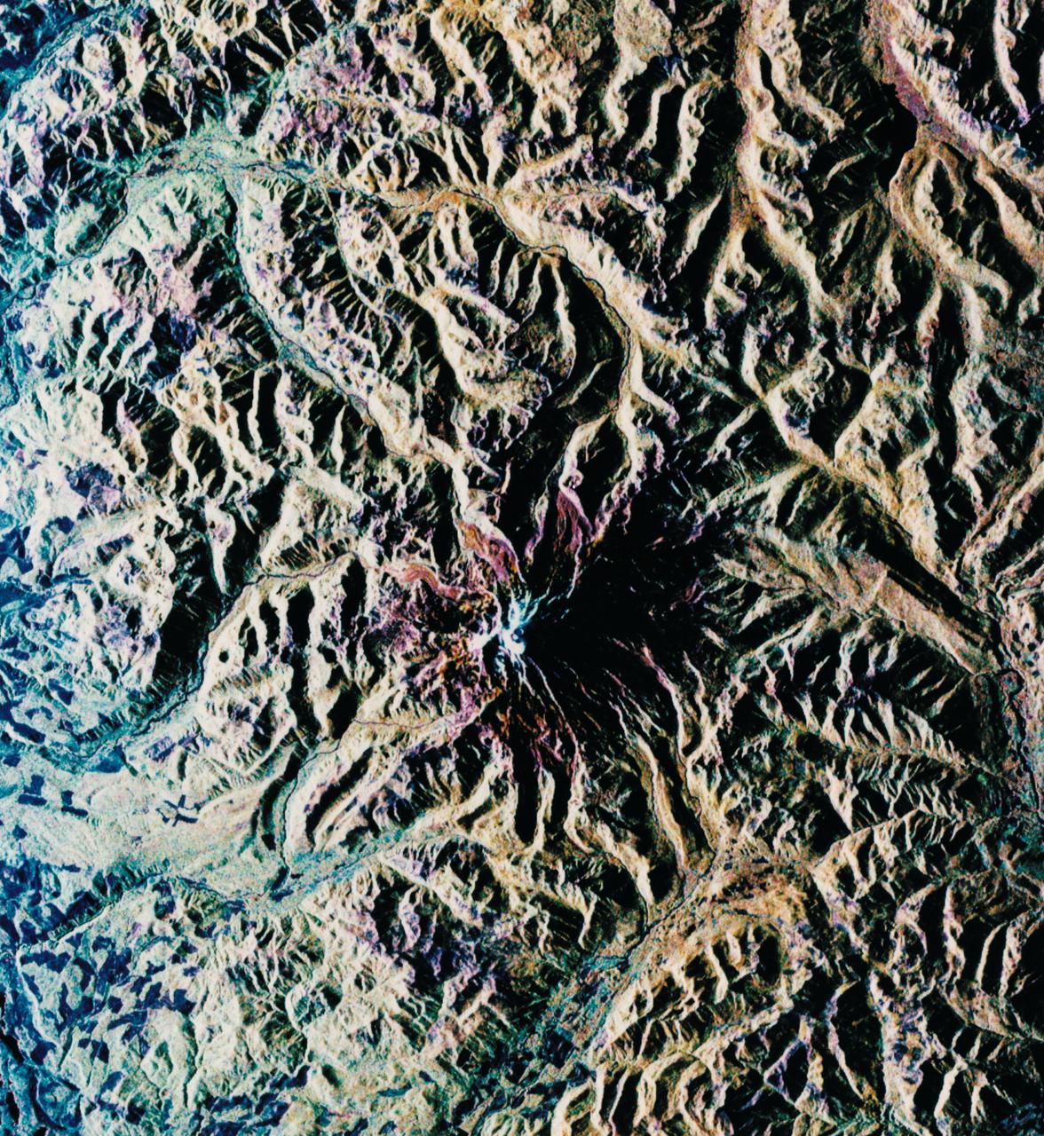
ISS033-E-022852 (18 Nov. 2012) --- This view, photographed by an Expedition 33 crew member on the International Space Station, highlights the 24-kilometer wide Aso caldera on the Japanese Island of Kyushu, formed during four explosive eruptions that took place from 300,000 to 90,000 years ago, according to scientists. These major eruptions produced pyroclastic flows and airfall tephra that covered much of Kyushu. As the eruptions emptied the magma chambers beneath the ancient volcanoes, they collapsed ? forming the caldera. Shadows highlight the caldera rim at left, while green vegetation covers slopes between the rim and caldera floor at right. Volcanic activity continued in the caldera following its formation, represented by 17 younger volcanoes including Naka-dake at center. Naka-dake is one of Japan?s most active volcanoes, with ash plumes produced from the summit crater as recently as June 2011. Another prominent crater, Kusasenri, is visible to the west of Naka-dake. This crater is the site of the Aso Volcano Museum as well as pasture for cows and horses. The Aso caldera floor is largely occupied by urban and agricultural land uses that present a gray to white speckled appearance in the image. Fields and cities surround the younger volcanic structures in the caldera center to the north, west, and south. Tan to yellow-brown regions along the crater rim, and along the lower slopes of the younger volcanic highlands in the central caldera, are lacking the dense tree cover indicated by greener areas in the image.

NASA image captured December 6, 2010 To view a video of this event go here: <a href="http://www.flickr.com/photos/gsfc/5258354738">www.flickr.com/photos/gsfc/5258354738</a> A very long solar filament that had been snaking around the Sun erupted (Dec. 6, 2010) with a flourish. STEREO (Behind) caught the action in dramatic detail in extreme ultraviolet light of Helium. It had been almost a million km long (about half a solar radius) and a prominent feature on the Sun visible over two weeks earlier before it rotated out of view. Filaments, elongated clouds of cooler gases suspended above the Sun by magnetic forces, are rather unstable and often break away from the Sun. Credit: NASA/GSFC/SOHO <b><a href="http://www.nasa.gov/centers/goddard/home/index.html" rel="nofollow">NASA Goddard Space Flight Center</a></b> enables NASA’s mission through four scientific endeavors: Earth Science, Heliophysics, Solar System Exploration, and Astrophysics. Goddard plays a leading role in NASA’s accomplishments by contributing compelling scientific knowledge to advance the Agency’s mission. <b>Follow us on <a href="http://twitter.com/NASA_GoddardPix" rel="nofollow">Twitter</a></b> <b>Join us on <a href="http://www.facebook.com/pages/Greenbelt-MD/NASA-Goddard/395013845897?ref=tsd" rel="nofollow">Facebook</a></b>
A sequence of full disk Io images was taken prior to Galileo's second encounter with Ganymede. The purpose of these observations was to view all longitudes of Io and search for active volcanic plumes. The images were taken at intervals of approximately one hour corresponding to Io longitude increments of about ten degrees. Because both the spacecraft and Io were traveling around Jupiter the lighting conditions on Io (e.g. the phase of Io) changed dramatically during the sequence. These images were registered at a common scale and processed to produce a time-lapse "movie" of Io. This movie combines all of the plume monitoring frames obtained by the Solid State Imaging system aboard NASA's Galileo spacecraft. The most prominent volcanic plume seen in this movie is Prometheus (latitude 1.6 south, longitude 153 west). The plume becomes visible as it moves into daylight, crosses the center of the disk, and is seen in profile against the dark of space at the edge of Io. This plume was first seen by the Voyager 1 spacecraft in 1979 and is believed to be a geyser-like eruption of sulfur dioxide snow and gas. Although details of the region around Prometheus have changed in the seventeen years since Voyager's visit, the shape and height of the plume have not changed significantly. It is possible that this geyser has been erupting nearly continuously over this time. Galileo's primary 24 month mission includes eleven orbits around Jupiter and will provide observations of Jupiter, its moons and its magnetosphere. North is to the top of all frames. The smallest features which can be discerned range from 13 to 31 kilometers across. The images were obtained between the 2nd and the 6th of September, 1996. The animation can be viewed at http://photojournal.jpl.nasa.gov/catalog/PIA01073
Caption: This image from June 20, 2013, at 11:15 p.m. EDT shows the bright light of a solar flare on the left side of the sun and an eruption of solar material shooting through the sun’s atmosphere, called a prominence eruption. Shortly thereafter, this same region of the sun sent a coronal mass ejection out into space. --- On June 20, 2013, at 11:24 p.m., the sun erupted with an Earth-directed coronal mass ejection or CME, a solar phenomenon that can send billions of tons of particles into space that can reach Earth one to three days later. These particles cannot travel through the atmosphere to harm humans on Earth, but they can affect electronic systems in satellites and on the ground. Experimental NASA research models, based on observations from NASA’s Solar Terrestrial Relations Observatory and ESA/NASA’s Solar and Heliospheric Observatory show that the CME left the sun at speeds of around 1350 miles per second, which is a fast speed for CMEs. Earth-directed CMEs can cause a space weather phenomenon called a geomagnetic storm, which occurs when they funnel energy into Earth's magnetic envelope, the magnetosphere, for an extended period of time. The CME’s magnetic fields peel back the outermost layers of Earth's fields changing their very shape. Magnetic storms can degrade communication signals and cause unexpected electrical surges in power grids. They also can cause aurora. Storms are rare during solar minimum, but as the sun’s activity ramps up every 11 years toward solar maximum – currently expected in late 2013 -- large storms occur several times per year. In the past, geomagnetic storms caused by CMEs of this strength and direction have usually been mild. Credit: NASA/Goddard/SDO <b><a href="http://www.nasa.gov/audience/formedia/features/MP_Photo_Guidelines.html" rel="nofollow">NASA image use policy.</a></b> <b><a href="http://www.nasa.gov/centers/goddard/home/index.html" rel="nofollow">NASA Goddard Space Flight Center</a></b> enables NASA’s mission through four scientific endeavors: Earth Science, Heliophysics, Solar System Exploration, and Astrophysics. Goddard plays a leading role in NASA’s accomplishments by contributing compelling scientific knowledge to advance the Agency’s mission. <b>Follow us on <a href="http://twitter.com/NASA_GoddardPix" rel="nofollow">Twitter</a></b> <b>Like us on <a href="http://www.facebook.com/pages/Greenbelt-MD/NASA-Goddard/395013845897?ref=tsd" rel="nofollow">Facebook</a></b> <b>Find us on <a href="http://instagram.com/nasagoddard?vm=grid" rel="nofollow">Instagram</a></b>

Caption: This image from June 20, 2013, at 11:15 p.m. EDT shows the bright light of a solar flare on the left side of the sun and an eruption of solar material shooting through the sun’s atmosphere, called a prominence eruption. Shortly thereafter, this same region of the sun sent a coronal mass ejection out into space. --- On June 20, 2013, at 11:24 p.m., the sun erupted with an Earth-directed coronal mass ejection or CME, a solar phenomenon that can send billions of tons of particles into space that can reach Earth one to three days later. These particles cannot travel through the atmosphere to harm humans on Earth, but they can affect electronic systems in satellites and on the ground. Experimental NASA research models, based on observations from NASA’s Solar Terrestrial Relations Observatory and ESA/NASA’s Solar and Heliospheric Observatory show that the CME left the sun at speeds of around 1350 miles per second, which is a fast speed for CMEs. Earth-directed CMEs can cause a space weather phenomenon called a geomagnetic storm, which occurs when they funnel energy into Earth's magnetic envelope, the magnetosphere, for an extended period of time. The CME’s magnetic fields peel back the outermost layers of Earth's fields changing their very shape. Magnetic storms can degrade communication signals and cause unexpected electrical surges in power grids. They also can cause aurora. Storms are rare during solar minimum, but as the sun’s activity ramps up every 11 years toward solar maximum – currently expected in late 2013 -- large storms occur several times per year. In the past, geomagnetic storms caused by CMEs of this strength and direction have usually been mild. Read more: <a href="http://1.usa.gov/14OxuEe" rel="nofollow">1.usa.gov/14OxuEe</a> Credit: NASA/Goddard/SDO <b><a href="http://www.nasa.gov/audience/formedia/features/MP_Photo_Guidelines.html" rel="nofollow">NASA image use policy.</a></b> <b><a href="http://www.nasa.gov/centers/goddard/home/index.html" rel="nofollow">NASA Goddard Space Flight Center</a></b> enables NASA’s mission through four scientific endeavors: Earth Science, Heliophysics, Solar System Exploration, and Astrophysics. Goddard plays a leading role in NASA’s accomplishments by contributing compelling scientific knowledge to advance the Agency’s mission. <b>Follow us on <a href="http://twitter.com/NASA_GoddardPix" rel="nofollow">Twitter</a></b> <b>Like us on <a href="http://www.facebook.com/pages/Greenbelt-MD/NASA-Goddard/395013845897?ref=tsd" rel="nofollow">Facebook</a></b> <b>Find us on <a href="http://instagram.com/nasagoddard?vm=grid" rel="nofollow">Instagram</a></b>

This Chandra X-Ray Observatory image of the mysterious superstar Eta Carinae reveals a surprising hot irner core, creating more questions than answers for astronomers. The image shows three distinct structures: An outer, horseshoe shaped ring about 2 light-years in diameter, a hot inner core about 3 light-months in diameter, and a hot central source less than a light-month in diameter which may contain the superstar. In 1 month, light travels a distance of approximately 489 billion miles (about 788 billion kilometers). All three structures are thought to represent shock waves produced by matter rushing away from the superstar at supersonic speeds. The temperature of the shock-heated gas ranges from 60 million degrees Kelvin in the central regions to 7 million degrees Kelvin on the outer structure. Eta Carinae is one of the most enigmatic and intriguing objects in our galaxy. Between 1837 and 1856, it increased dramatically in brightness to become the most prominent star in the sky except for Sirius, even through it is 7,500 light-years away, more than 80 times the distance to Sirius. This "Great Eruption," as it is called, had an energy comparable to a supernova, yet did not destroy the star, which faded to become a dim star, invisible to the naked eye. Since 1940, Eta Carinae has begun to brighten again, becoming visible to the naked eye. Photo credit: NASA/CXC/SAO
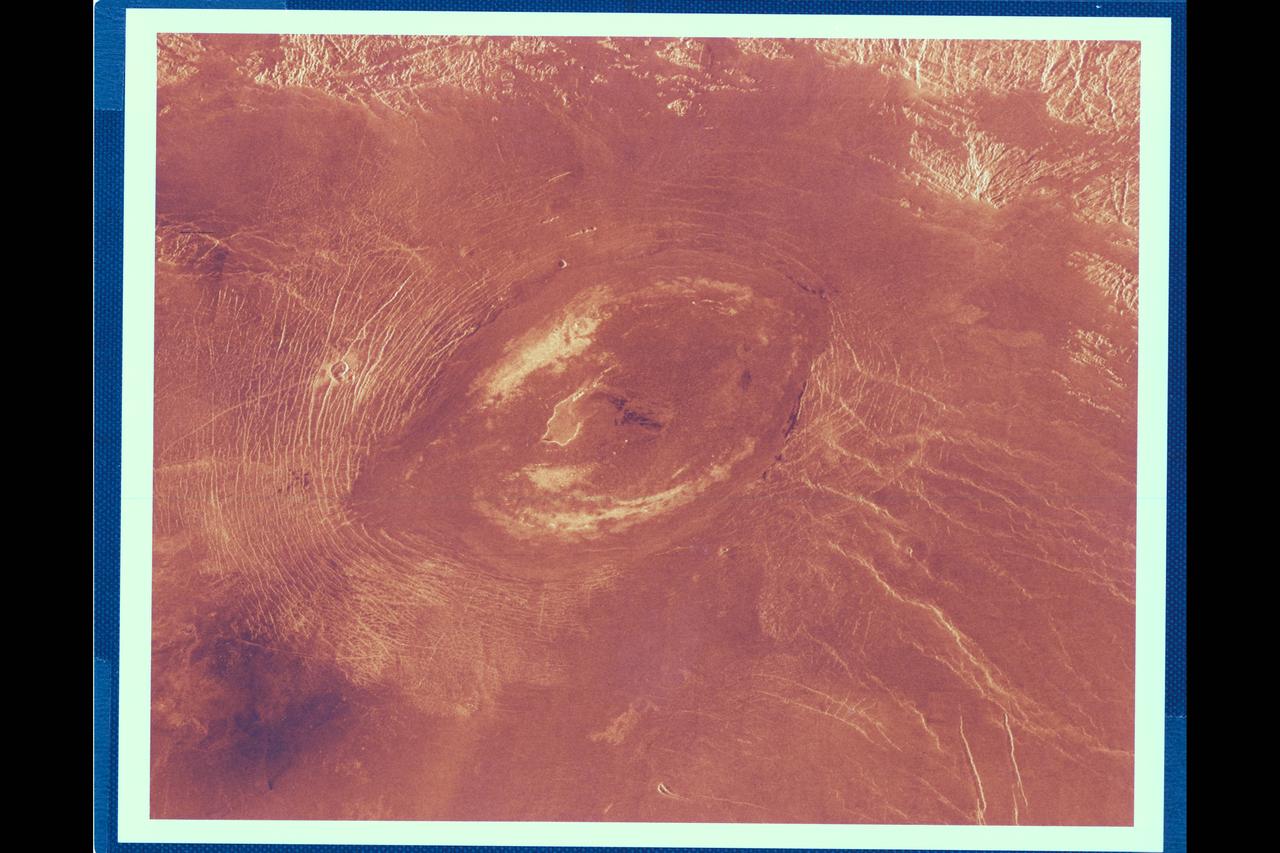
This Magellan image reveals Sacajawea Patera, a large, elongate caldera located in wester Ishtar Terra on the smooth plateau of Lakshmi Planum. The image is centered at 64.5 degrees north latitude adn 337 degrees east longitude. It is approx. 420 km (252 mi.) wide at the base Sacajawea is a depression approx. 1-2 km (0.6-1.2 mi.) deep and 120 by 215 km (74 by 133 mi.) in diameter; it is elongate in a sousthwest-northeast direction. The depression is interpreted to be graben adn fault scarps. These structures are space 0.5 to 4 km (0.3 to 2.5 mi.) apart, are 0.6 to 4 km (0.4 to 2.5 mi.) in width and up to 100 km (62 mi.) in length. Extending up to 140 km (87 mi.) in length from the southeast of the patera is a system of linear structures thought to represent a flanking rift zone along which the lateral injection and eruption of magma may have occurred. A shield edifice 12 km (7 mi.) in diameter with a prominent central pit lies along the trend of one of these features. The impact crater zlata, approx. 6 km (4 mi.) in diameter is located within the zone of graben to the northwest of the patera. Few flow features are observed in association with sacajawea, possibly due to age and state of degradation of the flows. Mottled bright deposits 4 to 20 km (2.5 to 12 mi.) in width are located near the periphery and in the center of the patera floor within local topographic lows. Diffuse patches of dark material approx. 40 km (25 mi.) in width are observed southwest of the patera, superimposed on portions of the surrounding graben. The formation of sacajawea is thought to be related to the drainage and collapse of a large magma chamber. Gravitational relaxation may have caused the resultant caldera to sag, producing the numerous complex, highly deformed tessera-like terrain are located north and east of the patera and are seen in the upper portion of the image. Color has been added to this image to simulate the appearance of the Venus surface.
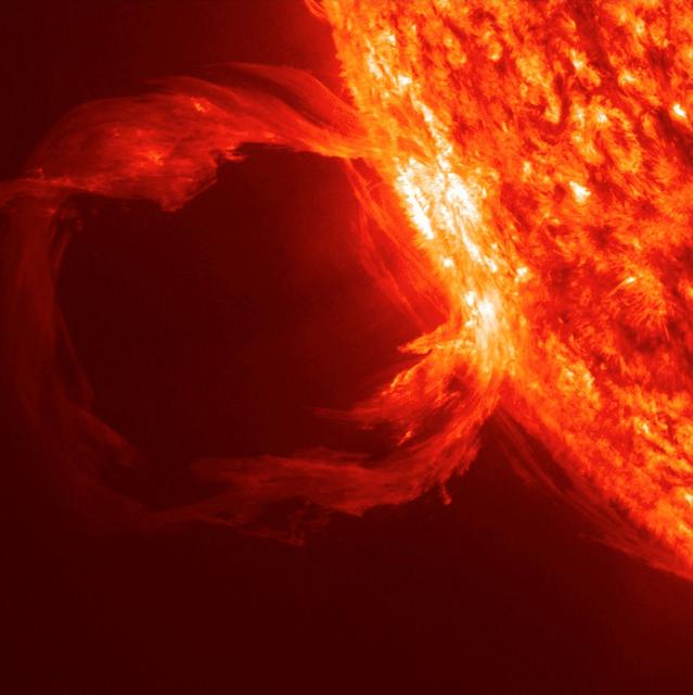
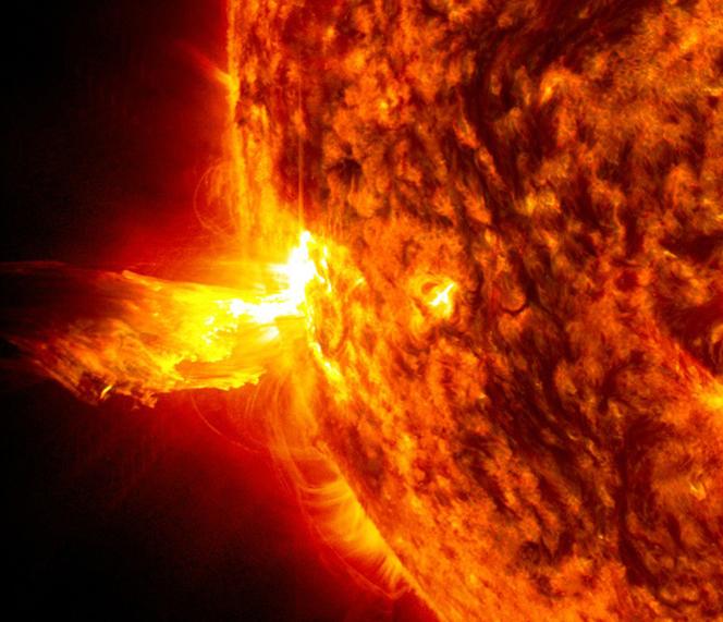
NASA image captured Feb. 24, 2011 To see an image showing the size of the prominence in comparison to the <b><a href="http://www.flickr.com/photos/gsfc/5492781335/">size of earth click here.</a></b> To view a video of this event go to: <a href="http://www.flickr.com/photos/gsfc/5483193591">www.flickr.com/photos/gsfc/5483193591</a> When a rather large-sized (M 3.6 class) flare occurred near the edge of the Sun, it blew out a gorgeous, waving mass of erupting plasma that swirled and twisted over a 90-minute period (Feb. 24, 2011). This event was captured in extreme ultraviolet light by NASA's Solar Dynamics Observatory spacecraft . Some of the material blew out into space and other portions fell back to the surface. Because SDO images are super-HD, we can zoom in on the action and still see exquisite details. And using a cadence of a frame taken every 24 seconds, the sense of motion is, by all appearances, seamless. Sit back and enjoy the jaw-dropping solar show. Credit: NASA/GSFC/SDO <b><a href="http://www.nasa.gov/centers/goddard/home/index.html" rel="nofollow">NASA Goddard Space Flight Center</a></b> enables NASA’s mission through four scientific endeavors: Earth Science, Heliophysics, Solar System Exploration, and Astrophysics. Goddard plays a leading role in NASA’s accomplishments by contributing compelling scientific knowledge to advance the Agency’s mission. <b>Follow us on <a href="http://twitter.com/NASA_GoddardPix" rel="nofollow">Twitter</a></b> <b>Join us on <a href="http://www.facebook.com/pages/Greenbelt-MD/NASA-Goddard/395013845897?ref=tsd" rel="nofollow">Facebook</a></b>
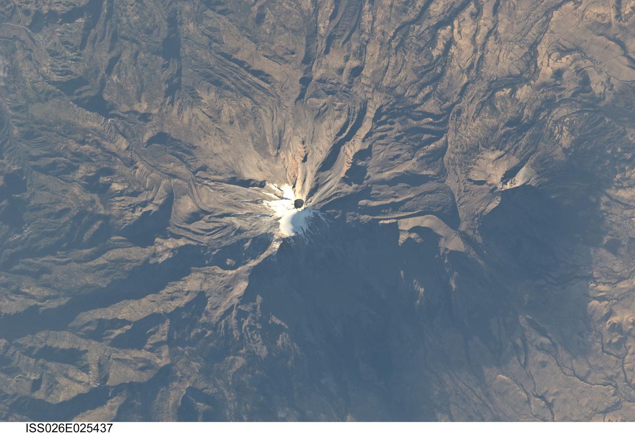
ISS026-E-025437 (10 Feb. 2011) --- Pico de Orizaba, Mexico is featured in this image photographed by an Expedition 26 crew member on the International Space Station. The snow and ice-clad peak of Pico de Orizaba (also known as Citlaltepetl) boasts a summit elevation of 5,675 meters (18,619 feet) above sea level, making it the highest peak in Mexico and North America’s highest volcano. It is also one of three volcanic peaks in Mexico—together with Popocatepetl and Iztaccihuatl—that retain summit glaciers. Pico de Orizaba is part of the Trans-Mexican Volcanic Belt that extends roughly east-west across Mexico. The last recorded eruption took place in 1846; while the volcano is considered dormant at present, geologists continue to investigate the potential hazards associated with a renewal of activity. Shadows accentuate several features of the Pico de Orizaba stratovolcano visible in this photograph from the space station. The 300-meter-deep summit crater is clearly visible against surrounding ice and snow cover at center. Several lava flows extend down the flanks of the volcano, made readily visible by prominent cooling ridges along their sides known as flow levees—one of the most clearly visible examples is located on the southwest flank of the cone. The extinct Sierra Negra volcano to the southwest has a summit elevation of 4,640 meters (15,223 feet) above sea level; while not as lofty as Pico de Orizaba, it is also one of Mexico’s highest peaks.
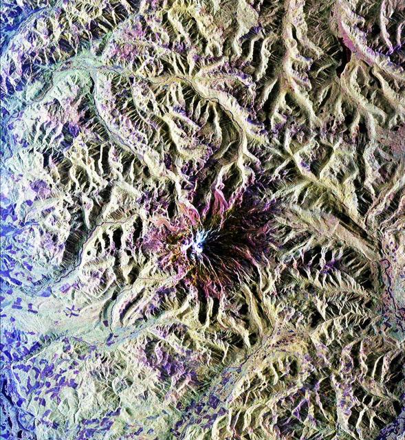
Situated in the southern Andes Mountains, the Payún volcanic field of Argentina is a complex landscape that formed over hundreds of thousands of years. Sprawling over 5,200 square kilometers (2,000 square miles), Payún is a massive shield volcano—a broad formation resembling an ancient warrior shield. This false-color image is a composite of observations acquired on February 7 and March 20, 2001 by the Enhanced Thematic Mapper Plus on the Landsat 7 satellite. It was made from a combination of visible and infrared light, where green indicates vegetation, black indicates lava flows, and orange is bare rock rich in iron oxides. Part of the back-arc volcanism of the Andes, Payún lies about 530 kilometers (330 miles) east from where the Nazca plate subducts below the South America plate. Not surprisingly, a volcanic zone extends over some 1,000 kilometers (600 miles) north-to-south in this region. According to a study published in 2010, the regional geology and chemical composition of the rocks indicate that the volcanic field likely formed within the past 300,000 years. The dominant feature of the volcanic field is Payún Matru, an elliptical caldera measuring roughly 9 by 7 kilometers (6 by 4 miles). Geologists surmise that the caldera formed after the old magma chamber emptied and the summit collapsed. Southwest of the caldera is a stratovolcano composed of alternating layers of compacted ash, hardened lava, and rocks ejected during previous eruptions. This stratovolcano, Payún, rises to 3,680 meters (12,073 feet) above sea level. (The entire volcanic field sits at 2,000 meters, or 6,600 feet.) The stratovolcano may be the most prominent feature in the volcanic field but it is by no means the only one. More than 300 eruptive features litter the shield volcano, most of them occupying an east-west line. West of Payún Matru is an area known as Los Volcanes, a mass of strombolian cones and basaltic lava flows. Image courtesy Michael P. Taylor, Landsat Data Continuity Mission Project Office, NASA Goddard Space Flight Center. Caption by Michon Scott with information from Michael Abrams, NASA Jet Propulsion Laboratory. Instrument: Landsat 7 - ETM+ To read more go to: <a href="http://1.usa.gov/UO8CbF" rel="nofollow">1.usa.gov/UO8CbF</a> Credit: <b><a href="http://www.earthobservatory.nasa.gov/" rel="nofollow"> NASA Earth Observatory</a></b> <b><a href="http://www.nasa.gov/audience/formedia/features/MP_Photo_Guidelines.html" rel="nofollow">NASA image use policy.</a></b> <b><a href="http://www.nasa.gov/centers/goddard/home/index.html" rel="nofollow">NASA Goddard Space Flight Center</a></b> enables NASA’s mission through four scientific endeavors: Earth Science, Heliophysics, Solar System Exploration, and Astrophysics. Goddard plays a leading role in NASA’s accomplishments by contributing compelling scientific knowledge to advance the Agency’s mission. <b>Follow us on <a href="http://twitter.com/NASA_GoddardPix" rel="nofollow">Twitter</a></b> <b>Like us on <a href="http://www.facebook.com/pages/Greenbelt-MD/NASA-Goddard/395013845897?ref=tsd" rel="nofollow">Facebook</a></b> <b>Find us on <a href="http://instagram.com/nasagoddard?vm=grid" rel="nofollow">Instagram</a></b>
ISS030-E-035487 (14 Jan. 2012) --- The East African Rift Valley in Kenya is featured in this image photographed by an Expedition 30 crew member on the International Space Station. This photograph highlights classical geological structures associated with a tectonic rift valley, in this case the Eastern Branch of the East African Rift near Kenya’s southern border with Tanzania and just south of the Equator. The East African Rift is one of the great tectonic features of Africa, caused by fracturing of Earth’s crust. The Nubian (or African) plate includes the older continental crust of Africa to the west, while the Somalian plate that is moving away includes the Horn of Africa to the northeast; the tectonic boundary stretches from the southern Red Sea to central Mozambique. Landscapes in the rift valley can appear confusing. The most striking features in this view are the numerous, nearly parallel, linear fault lines that occupy the floor of the valley (most of the image). Shadows cast by the late afternoon sun make the fault scarps (steps in the landscape caused by slip motion along individual faults) more prominent. The faults are aligned with the north-south axis of the valley (lower left to top right). A secondary trend of less linear faults cuts the main fault trend at an acute angle, the fault steps throwing large shadows. The Eastern Branch of the East African Rift is arid (compared with the Western Branch which lies on the border of the Congolese rainforest). Evidence of this can be seen in the red, salt-loving algae of the shallow and salty Lake Magadi (center). A neighboring small lake to the north has deeper water and appears dark in the image. The white salt deposits of the dry part of the Lake Magadi floor (center) host a few small commercial salt pans. The lakes appear to be located where the main and secondary fault trends intersect. The East African rift system is marked by substantial volcanic activity, including lavas erupted from fissures along the rift in the region. Much of the faulting observed in this image cuts through such lavas. Elsewhere along the rift system individual volcanoes form. Some of those volcanoes are very large, including Mt. Kilimanjaro and Mt. Kenya. In this image, rising 400 meters above the valley floor, a volcano appears to be superimposed on the faults—indicating that the volcano is younger than the faults it covers. Deeply eroded slopes also suggest that the volcano has not been active for a long time. The largest vegetated area (lower left)—in an desert zone with no vegetation visible to the naked eye from space—is the green floor of a valley which drains an area large enough for water to exist near the surface so that plants can thrive. For a sense of scale, the vegetated valley floor is 17 kilometers long (10.5 miles).
This is a radar image of Mount Rainier in Washington state. The volcano last erupted about 150 years ago and numerous large floods and debris flows have originated on its slopes during the last century. Today the volcano is heavily mantled with glaciers and snowfields. More than 100,000 people live on young volcanic mudflows less than 10,000 years old and, consequently, are within the range of future, devastating mudslides. This image was acquired by the Spaceborne Imaging Radar-C and X-band Synthetic Aperture Radar (SIR-C/X-SAR) aboard the space shuttle Endeavour on its 20th orbit on October 1, 1994. The area shown in the image is approximately 59 kilometers by 60 kilometers (36.5 miles by 37 miles). North is toward the top left of the image, which was composed by assigning red and green colors to the L-band, horizontally transmitted and vertically, and the L-band, horizontally transmitted and vertically received. Blue indicates the C-band, horizontally transmitted and vertically received. In addition to highlighting topographic slopes facing the space shuttle, SIR-C records rugged areas as brighter and smooth areas as darker. The scene was illuminated by the shuttle's radar from the northwest so that northwest-facing slopes are brighter and southeast-facing slopes are dark. Forested regions are pale green in color; clear cuts and bare ground are bluish or purple; ice is dark green and white. The round cone at the center of the image is the 14,435-foot (4,399-meter) active volcano, Mount Rainier. On the lower slopes is a zone of rock ridges and rubble (purple to reddish) above coniferous forests (in yellow/green). The western boundary of Mount Rainier National Park is seen as a transition from protected, old-growth forest to heavily logged private land, a mosaic of recent clear cuts (bright purple/blue) and partially regrown timber plantations (pale blue). The prominent river seen curving away from the mountain at the top of the image (to the northwest) is the White River, and the river leaving the mountain at the bottom right of the image (south) is the Nisqually River, which flows out of the Nisqually glacier on the mountain. The river leaving to the left of the mountain is the Carbon River, leading west and north toward heavily populated regions near Tacoma. The dark patch at the top right of the image is Bumping Lake. Other dark areas seen to the right of ridges throughout the image are radar shadow zones. Radar images can be used to study the volcanic structure and the surrounding regions with linear rock boundaries and faults. In addition, the recovery of forested lands from natural disasters and the success of reforestation programs can also be monitored. Ultimately this data may be used to study the advance and retreat of glaciers and other forces of global change. http://photojournal.jpl.nasa.gov/catalog/PIA01727

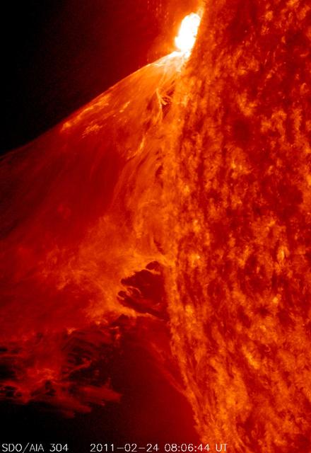
Caption: A burst of solar material leaps off the left side of the sun in what’s known as a prominence eruption. This image combines three images from NASA’s Solar Dynamics Observatory captured on May 3, 2013, at 1:45 pm EDT, just as an M-class solar flare from the same region was subsiding. The images include light from the 131, 171 and 304 Angstrom wavelengths. Credit: NASA/Goddard/SDO --- The sun emitted a mid-level solar flare, peaking at 1:32 pm EDT on May 3, 2013. Solar flares are powerful bursts of radiation. Harmful radiation from a flare cannot pass through Earth's atmosphere to physically affect humans on the ground, however -- when intense enough -- they can disturb the atmosphere in the layer where GPS and communications signals travel. This disrupts the radio signals for as long as the flare is ongoing, and the radio blackout for this flare has already subsided. This flare is classified as an M5.7 class flare. M-class flares are the weakest flares that can still cause some space weather effects near Earth. Increased numbers of flares are quite common at the moment, since the sun's normal 11-year activity cycle is ramping up toward solar maximum, which is expected in late 2013. Updates will be provided as they are available on the flare and whether there was an associated coronal mass ejection (CME), another solar phenomenon that can send solar particles into space and affect electronic systems in satellites and on Earth. <b><a href="http://www.nasa.gov/audience/formedia/features/MP_Photo_Guidelines.html" rel="nofollow">NASA image use policy.</a></b> <b><a href="http://www.nasa.gov/centers/goddard/home/index.html" rel="nofollow">NASA Goddard Space Flight Center</a></b> enables NASA’s mission through four scientific endeavors: Earth Science, Heliophysics, Solar System Exploration, and Astrophysics. Goddard plays a leading role in NASA’s accomplishments by contributing compelling scientific knowledge to advance the Agency’s mission. <b>Follow us on <a href="http://twitter.com/NASA_GoddardPix" rel="nofollow">Twitter</a></b> <b>Like us on <a href="http://www.facebook.com/pages/Greenbelt-MD/NASA-Goddard/395013845897?ref=tsd" rel="nofollow">Facebook</a></b> <b>Find us on <a href="http://instagram.com/nasagoddard?vm=grid" rel="nofollow">Instagram</a></b>

What looks much like craggy mountains on a moonlit evening is actually the edge of a nearby, young, star-forming region NGC 3324 in the Carina Nebula. Captured in infrared light by the Near-Infrared Camera (NIRCam) on NASA’s James Webb Space Telescope, this image reveals previously obscured areas of star birth. Called the Cosmic Cliffs, the region is actually the edge of a gigantic, gaseous cavity within NGC 3324, roughly 7,600 light-years away. The cavernous area has been carved from the nebula by the intense ultraviolet radiation and stellar winds from extremely massive, hot, young stars located in the center of the bubble, above the area shown in this image. The high-energy radiation from these stars is sculpting the nebula’s wall by slowly eroding it away. NIRCam – with its crisp resolution and unparalleled sensitivity – unveils hundreds of previously hidden stars, and even numerous background galaxies. Several prominent features in this image are described below. • The “steam” that appears to rise from the celestial “mountains” is actually hot, ionized gas and hot dust streaming away from the nebula due to intense, ultraviolet radiation. • Dramatic pillars rise above the glowing wall of gas, resisting the blistering ultraviolet radiation from the young stars. • Bubbles and cavities are being blown by the intense radiation and stellar winds of newborn stars. • Protostellar jets and outflows, which appear in gold, shoot from dust-enshrouded, nascent stars. • A “blow-out” erupts at the top-center of the ridge, spewing gas and dust into the interstellar medium. • An unusual “arch” appears, looking like a bent-over cylinder. This period of very early star formation is difficult to capture because, for an individual star, it lasts only about 50,000 to 100,000 years – but Webb’s extreme sensitivity and exquisite spatial resolution have chronicled this rare event. Located roughly 7,600 light-years away, NGC 3324 was first catalogued by James Dunlop in 1826. Visible from the Southern Hemisphere, it is located at the northwest corner of the Carina Nebula (NGC 3372), which resides in the constellation Carina. The Carina Nebula is home to the Keyhole Nebula and the active, unstable supergiant star called Eta Carinae. NIRCam was built by a team at the University of Arizona and Lockheed Martin’s Advanced Technology Center.
Caption: A burst of solar material leaps off the left side of the sun in what’s known as a prominence eruption. This image combines three images from NASA’s Solar Dynamics Observatory captured on May 3, 2013, at 1:45 pm EDT, just as an M-class solar flare from the same region was subsiding. The images include light from the 131, 171 and 304 Angstrom wavelengths. Credit: NASA/Goddard/SDO --- The sun emitted a mid-level solar flare, peaking at 1:32 pm EDT on May 3, 2013. Solar flares are powerful bursts of radiation. Harmful radiation from a flare cannot pass through Earth's atmosphere to physically affect humans on the ground, however -- when intense enough -- they can disturb the atmosphere in the layer where GPS and communications signals travel. This disrupts the radio signals for as long as the flare is ongoing, and the radio blackout for this flare has already subsided. This flare is classified as an M5.7 class flare. M-class flares are the weakest flares that can still cause some space weather effects near Earth. Increased numbers of flares are quite common at the moment, since the sun's normal 11-year activity cycle is ramping up toward solar maximum, which is expected in late 2013. Updates will be provided as they are available on the flare and whether there was an associated coronal mass ejection (CME), another solar phenomenon that can send solar particles into space and affect electronic systems in satellites and on Earth. <b><a href="http://www.nasa.gov/audience/formedia/features/MP_Photo_Guidelines.html" rel="nofollow">NASA image use policy.</a></b> <b><a href="http://www.nasa.gov/centers/goddard/home/index.html" rel="nofollow">NASA Goddard Space Flight Center</a></b> enables NASA’s mission through four scientific endeavors: Earth Science, Heliophysics, Solar System Exploration, and Astrophysics. Goddard plays a leading role in NASA’s accomplishments by contributing compelling scientific knowledge to advance the Agency’s mission. <b>Follow us on <a href="http://twitter.com/NASA_GoddardPix" rel="nofollow">Twitter</a></b> <b>Like us on <a href="http://www.facebook.com/pages/Greenbelt-MD/NASA-Goddard/395013845897?ref=tsd" rel="nofollow">Facebook</a></b> <b>Find us on <a href="http://instagram.com/nasagoddard?vm=grid" rel="nofollow">Instagram</a></b>
STS068-S-052 (3 October 1994) --- This is a radar image of Mount Rainier in Washington state. The volcano last erupted about 150 years ago and numerous large floods and debris flows have originated on its slopes during the last century. Today the volcano is heavily mantled with glaciers and snow fields. More than 100,000 people live on young volcanic mud flows less than 10,000 years old and, are within the range of future, devastating mud slides. This image was acquired by the Spaceborne Imaging Radar-C/X-Band Synthetic Aperture Radar (SIR-C/X-SAR) aboard the Space Shuttle Endeavour on its 20th orbit on October 1, 1994. The area shown in the image is approximately 59 by 60 kilometers (36.5 by 37 miles). North is toward the top left of the image, which was composed by assigning red and green colors to the L-Band, horizontally transmitted and vertically, and the L-Band, horizontally transmitted and vertically received. Blue indicates the C-Band, horizontally transmitted and vertically received. In addition to highlighting topographic slopes facing the Space Shuttle, SIR-C records rugged areas as brighter and smooth areas as darker. The scene was illuminated by the Shuttle's radar from the northwest so that northwest-facing slopes are brighter and southeast-facing slopes are dark. Forested regions are pale green in color, clear cuts and bare ground are bluish or purple; ice is dark green and white. The round cone at the center of the image is the 14,435 feet (4,399 meters) active volcano, Mount Rainier. On the lower slopes is a zone of rock ridges and rubble (purple to reddish) above coniferous forests (in yellow/green). The western boundary of Mount Rainier National Park is seen as a transition from protected, old-growth forest to heavily logged private land, a mosaic of recent clear cuts (bright purple/blue) and partially re-grown timber plantations (pale blue). The prominent river seen curving away from the mountain at the top of the image (to the northwest) is the White River, and the river leaving the mountain at the bottom right of the image (south) is the Nisqually River, which flows out of the Nisqually glacier on the mountain. The river leaving to the left of the mountain is the Carbon River, leading west and north toward heavily populated regions near Tacoma. The dark patch at the top right of the image is Bumping Lake. Other dark areas seen to the right of ridges throughout the image are radar shadow zones. Radar images can be used to study the volcanic structure and the surrounding regions with linear rock boundaries and faults. In addition, the recovery of forested lands from natural disasters and the success of re-forestation programs can also be monitored. Ultimately this data may be used to study the advance and retreat of glaciers and other forces of global change. Spaceborne Imaging Radar-C/X-Band Synthetic Aperture Radar (SIR-C/X-SAR) is part of NASA's Mission to Planet Earth. (P-44703)

NASA image release March 11, 2011 Caption: The lunar farside as never seen before! LROC WAC orthographic projection centered at 180° longitude, 0° latitude. Credit: NASA/Goddard/Arizona State University. Because the moon is tidally locked (meaning the same side always faces Earth), it was not until 1959 that the farside was first imaged by the Soviet Luna 3 spacecraft (hence the Russian names for prominent farside features, such as Mare Moscoviense). And what a surprise - unlike the widespread maria on the nearside, basaltic volcanism was restricted to a relatively few, smaller regions on the farside, and the battered highlands crust dominated. A different world from what we saw from Earth. Of course, the cause of the farside/nearside asymmetry is an interesting scientific question. Past studies have shown that the crust on the farside is thicker, likely making it more difficult for magmas to erupt on the surface, limiting the amount of farside mare basalts. Why is the farside crust thicker? That is still up for debate, and in fact several presentations at this week's Lunar and Planetary Science Conference attempt to answer this question. The Clementine mission obtained beautiful mosaics with the sun high in the sky (low phase angles), but did not have the opportunity to observe the farside at sun angles favorable for seeing surface topography. This WAC mosaic provides the most complete look at the morphology of the farside to date, and will provide a valuable resource for the scientific community. And it's simply a spectacular sight! The Lunar Reconnaissance Orbiter Camera (LROC) Wide Angle Camera (WAC) is a push-frame camera that captures seven color bands (321, 360, 415, 566, 604, 643, and 689 nm) with a 57-km swath (105-km swath in monochrome mode) from a 50 km orbit. One of the primary objectives of LROC is to provide a global 100 m/pixel monochrome (643 nm) base map with incidence angles between 55°-70° at the equator, lighting that is favorable for morphological interpretations. Each month, the WAC provides nearly complete coverage of the Moon under unique lighting. As an added bonus, the orbit-to-orbit image overlap provides stereo coverage. Reducing all these stereo images into a global topographic map is a big job, and is being led by LROC Team Members from the German Aerospace Center (Deutsches Zentrum für Luft- und Raumfahrt; DLR). Several preliminary WAC topographic products have appeared in LROC featured images over the past year (Orientale basin, Sinus Iridum). For a sneak preview of the WAC global DEM with the WAC global mosaic, view a rotating composite moon (70 MB video from ASU's LROC website). The WAC topographic dataset will be completed and released later this year. The global mosaic released today is comprised of over 15,000 WAC images acquired between November 2009 and February 2011. The non-polar images were map projected onto the GLD100 shape model (WAC derived 100 m/pixel DTM), while polar images were map projected on the LOLA shape model. In addition, the LOLA derived crossover corrected ephemeris, and an improved camera pointing, provide accurate positioning (better than 100 m) of each WAC image. As part of the March 2011 PDS release, the LROC team posted the global map in ten regional tiles. Eight of the tiles are equirectangular projections that encompass 60° latitude by 90° longitude. In addition, two polar stereographic projections are available for each pole from ±60° to the pole. These reduced data records (RDR) products will be available for download on March 15, 2011. As the mission progresses, and our knowledge of the lunar photometric function increases, improved and new mosaics will be released! Work your way around the moon with these six orthographic projections constructed from WAC mosaics. The nearside view linked below is different from that released on 21 February. To read more con't here: <a href="http://www.nasa.gov/mission_pages/LRO/news/lro-farside.html" rel="nofollow">www.nasa.gov/mission_pages/LRO/news/lro-farside.html</a> <b><a href="http://www.nasa.gov/centers/goddard/home/index.html" rel="nofollow">NASA Goddard Space Flight Center</a></b> enables NASA’s mission through four scientific endeavors: Earth Science, Heliophysics, Solar System Exploration, and Astrophysics. Goddard plays a leading role in NASA’s accomplishments by contributing compelling scientific knowledge to advance the Agency’s mission. <b>Follow us on <a href="http://twitter.com/NASA_GoddardPix" rel="nofollow">Twitter</a></b> <b>Join us on <a href="http://www.facebook.com/pages/Greenbelt-MD/NASA-Goddard/395013845897?ref=tsd" rel="nofollow">Facebook</a></b>