
The F-15 ACTIVE touches down on the Edwards runway following its April 14, 1998 flight. The nose is high while the canards have their rear edge raised. the aircraft's speed brake, located on the top of the aircraft behind the canopy, is also raised.

The F-15 ACTIVE in flight above the Mojave desert on April 14, 1998. The overhead shot shows the aircraft's striking red and while paint scheme/ The large forward canards are actually the tail surfaces from an F-18.

S104-E-5064 (15 July 2001) --- Michael L. Gernhardt (front), mission specialist and EV1, and James F. Reilly, mission specialist and EV2, work in the payload bay of the Space Shuttle Atlantis during the first extravehicular activity (EVA) of the STS-104 mission. This image was taken by a STS-104 crewmember in Atlantis with a digital still camera.
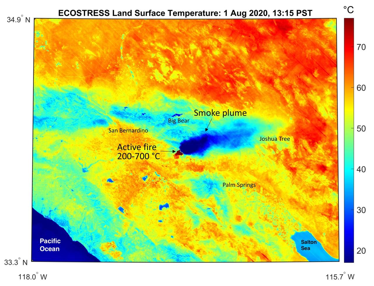
This temperature map shows the stressed and dry vegetation surrounding the Apple fire in Southern California on Aug. 1, 2020. The observation was made possible by NASA's Ecosystem Spaceborne Thermal Radiometer Experiment on Space Station (ECOSTRESS) that measured the temperature of the burn area and tracked the dark smoke plume drifting east from California to Arizona. ECOSTRESS collected this data when the space station passed over the region at about 1:15 p.m. PST on Saturday, Aug. 1, 2020, when the burn area was approximately 4,000 acres in size. Black smoke can be seen drifting east and over Joshua Tree National Park in the Mojave Desert. With a resolution of about 77 by 77 yards (70 by 70 meters), the image enables surface-temperature conditions down to the size of a football field to be studied. In the active burn area, temperatures of between 390-1290 F (200-700 C) were recorded, and in one pixel in the ECOSTRESS image of the burn zone, a peak temperature of 1387 F (753 C) was detected. Tasked with detecting plant water use and stress, ECOSTRESS measures the temperature of plants as they heat up when they run out of water. But it can also measure and track heat-related phenomena like fires, heat waves, and volcanoes. https://photojournal.jpl.nasa.gov/catalog/PIA23798
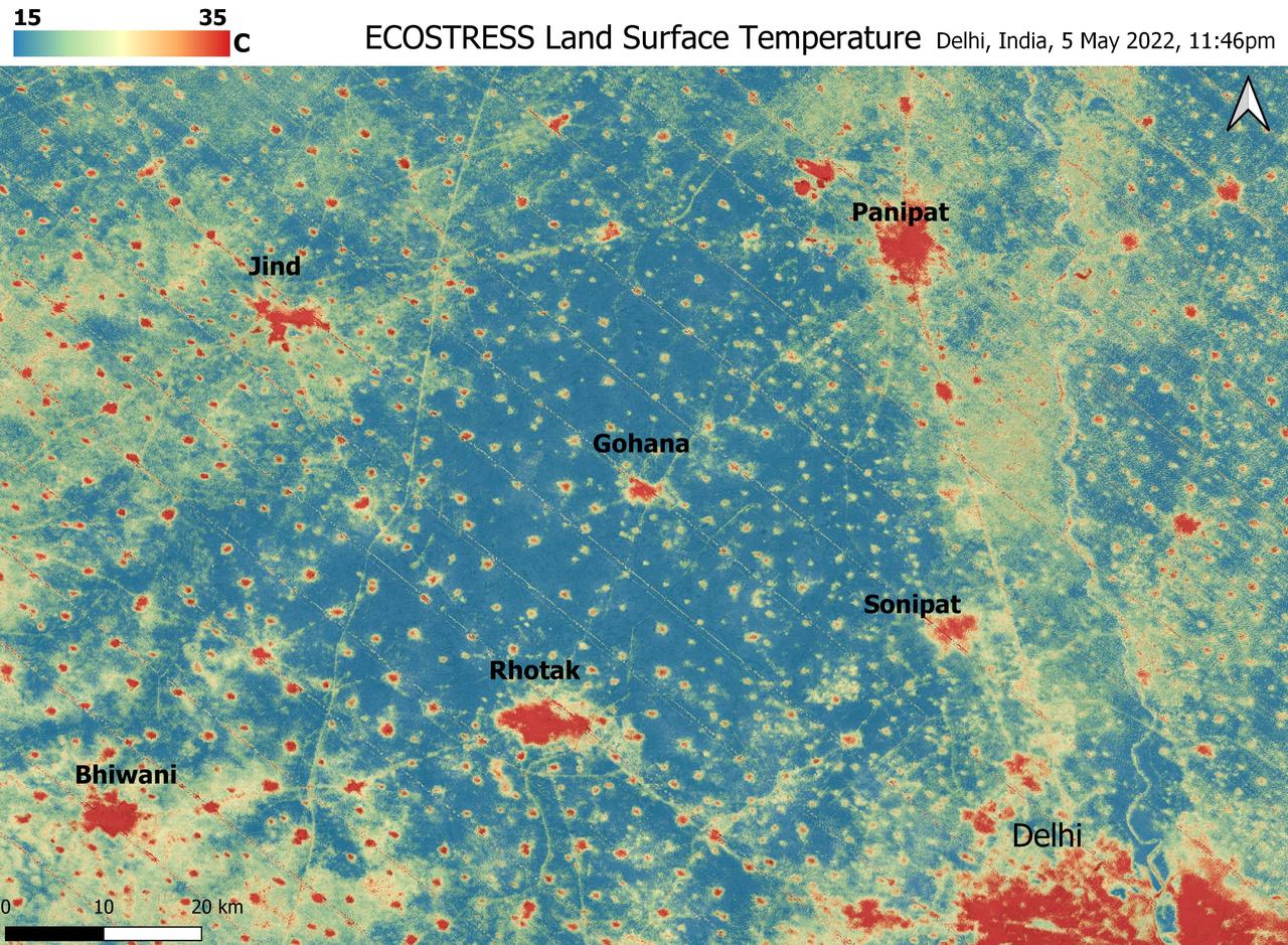
A relentless heat wave has blanketed India and Pakistan since mid-March 2022, causing dozens of deaths, fires, increased air pollution, and reduced crop yields. NASA's Ecosystem Spaceborne Thermal Radiometer Experiment on Space Station instrument (ECOSTRESS) has been measuring these temperatures from space, at the highest spatial resolution of any satellite instrument. This image, taken shortly before local midnight on May 5, shows urban areas and agricultural lands northwest of Delhi that are home to about 28 million people. The image covers about 4,800 square miles (12,350 square kilometers). Cities are usually markedly warmer than the surrounding countryside due to human activities and the materials used in the built environment. The image clearly delineates these urban "heat islands." Nighttime temperatures in Delhi and several smaller villages were above 95 degrees Fahrenheit (35 degrees Celsius), peaking at about 102 degrees F (39 degrees C), while the rural fields nearby had cooled to around 60 degrees F (15 degrees C). This data suggests that city dwellers are experiencing considerably higher temperatures than the average temperatures reported for their regions. ECOSTRESS measures the temperature of the ground itself, which is very similar to air temperature at night (though the ground may be warmer than the air in daylight hours). The instrument launched to the space station in 2018. Its primary mission is to identify plants' thresholds for water use and water stress, giving insight into their ability to adapt to a warming climate. However, ECOSTRESS also records other heat-related phenomena like this heat wave. Its high-resolution images, with a pixel size of about 225 feet (70 meters) by 125 feet (38 meters), are a powerful tool for understanding aspects of the weather event that might be overlooked by traditional observation networks. https://photojournal.jpl.nasa.gov/catalog/PIA24987
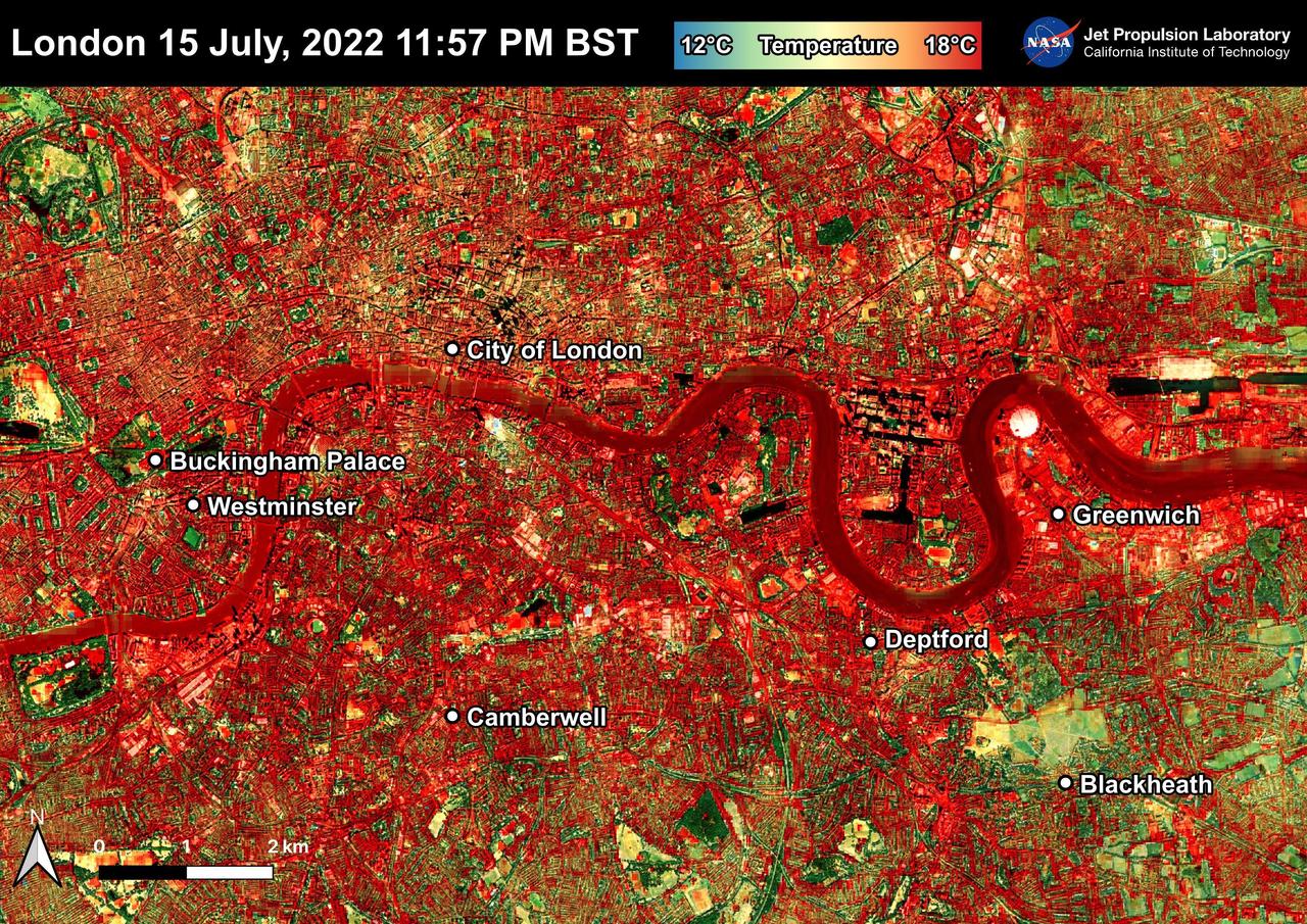
NASA's Ecosystem Spaceborne Thermal Radiometer Experiment on Space Station (ECOSTRESS) instrument recorded this image of ground surface temperatures in London and surrounding areas on July 15, 2022, just before midnight local time. It shows surface temperatures exceeding 68 degrees Fahrenheit (20 degrees Celsius) at 11:57 p.m. British Summer Time. Parts of Europe in mid-July experienced a record-breaking heat wave. The United Kingdom reaching its highest air temperature on record on July 19, 104.5 F (40.3 C) in Coningsby, about 110 miles (177 kilometers) north of London, which itself saw a high of 104.3 F (40.2 C) the same day. That evening, the overnight low was also a record-breaker: 78.4 F (25.8 C) at Kenley Airfield in Greater London. In this image, the red areas indicate hotter temperatures commonly associated with developed areas. These surfaces – roofs, paved streets, and other built structures – remain warm long after the sun sets. Blue and green areas indicate cooler areas commonly associated with parks and other natural land surfaces. Because this image was acquired at night, it shows bodies of water being warmer than the land surface. This is because water tends to change temperature more slowly, so its temperature stays elevated long after land surfaces have cooled down. Cities are usually warmer than open land with natural surfaces because of human activities as well as the materials used in building and construction. Streets are often the hottest part of the built environment due to asphalt paving. Dark-colored surfaces absorb more heat from the Sun than lighter-colored ones; asphalt absorbs up to 95% of solar radiation and retains the heat for hours into nighttime. This image overlays ECOSTRESS surface temperature data on a Google satellite map for context. ECOSTRESS measures the temperature of the ground, which is hotter than the air temperature during the daytime. The instrument launched to the space station in 2018. Its primary mission is to identify plants' thresholds for water use and water stress, giving insight into their ability to adapt to a warming climate. However, ECOSTRESS is also useful for documenting other heat-related phenomena, like patterns of heat absorption and retention. Its high-resolution images, with a pixel size of about 225 feet (70 meters) by 125 feet (38 meters), are a powerful tool for understanding our environment. https://photojournal.jpl.nasa.gov/catalog/PIA25423

This image depicts a vast canyon of dust and gas in the Orion Nebula from a 3-D computer model based on observations by NASA's Hubble Space Telescope and created by science visualization specialists at the Space Telescope Science Institute (STScI) in Baltimore, Md. A 3-D visualization of this model takes viewers on an amazing four-minute voyage through the 15-light-year-wide canyon. Credit: NASA, G. Bacon, L. Frattare, Z. Levay, and F. Summers (STScI/AURA) Go here to learn more about Hubble 3D: <a href="http://www.nasa.gov/topics/universe/features/hubble_imax_premiere.html" rel="nofollow">www.nasa.gov/topics/universe/features/hubble_imax_premier...</a> or <a href="http://www.imax.com/hubble/" rel="nofollow">www.imax.com/hubble/</a> Take an exhilarating ride through the Orion Nebula, a vast star-making factory 1,500 light-years away. Swoop through Orion's giant canyon of gas and dust. Fly past behemoth stars whose brilliant light illuminates and energizes the entire cloudy region. Zoom by dusty tadpole-shaped objects that are fledgling solar systems. This virtual space journey isn't the latest video game but one of several groundbreaking astronomy visualizations created by specialists at the Space Telescope Science Institute (STScI) in Baltimore, the science operations center for NASA's Hubble Space Telescope. The cinematic space odysseys are part of the new Imax film "Hubble 3D," which opens today at select Imax theaters worldwide. The 43-minute movie chronicles the 20-year life of Hubble and includes highlights from the May 2009 servicing mission to the Earth-orbiting observatory, with footage taken by the astronauts. The giant-screen film showcases some of Hubble's breathtaking iconic pictures, such as the Eagle Nebula's "Pillars of Creation," as well as stunning views taken by the newly installed Wide Field Camera 3. While Hubble pictures of celestial objects are awe-inspiring, they are flat 2-D photographs. For this film, those 2-D images have been converted into 3-D environments, giving the audience the impression they are space travelers taking a tour of Hubble's most popular targets. "A large-format movie is a truly immersive experience," says Frank Summers, an STScI astronomer and science visualization specialist who led the team that developed the movie visualizations. The team labored for nine months, working on four visualization sequences that comprise about 12 minutes of the movie. "Seeing these Hubble images in 3-D, you feel like you are flying through space and not just looking at picture postcards," Summers continued. "The spacescapes are all based on Hubble images and data, though some artistic license is necessary to produce the full depth of field needed for 3-D." The most ambitious sequence is a four-minute voyage through the Orion Nebula's gas-and-dust canyon, about 15 light-years across. During the ride, viewers will see bright and dark, gaseous clouds; thousands of stars, including a grouping of bright, hefty stars called the Trapezium; and embryonic planetary systems. The tour ends with a detailed look at a young circumstellar disk, which is much like the structure from which our solar system formed 4.5 billion years ago. Based on a Hubble image of Orion released in 2006, the visualization was a collaborative effort between science visualization specialists at STScI, including Greg Bacon, who sculpted the Orion Nebula digital model, with input from STScI astronomer Massimo Roberto; the National Center for Supercomputing Applications at the University of Illinois at Urbana-Champaign; and the Spitzer Science Center at the California Institute of Technology in Pasadena. For some of the sequences, STScI imaging specialists developed new techniques for transforming the 2-D Hubble images into 3-D. STScI image processing specialists Lisa Frattare and Zolt Levay, for example, created methods of splitting a giant gaseous pillar in the Carina Nebula into multiple layers to produce a 3-D effect, giving the structure depth. The Carina Nebula is a nursery for baby stars. Frattare painstakingly removed the thousands of stars in the image so that Levay could separate the gaseous layers on the isolated Carina pillar. Frattare then replaced the stars into both foreground and background layers to complete the 3-D model. For added effect, the same separation was done for both visible and infrared Hubble images, allowing the film to cross-fade between wavelength views in 3-D. In another sequence viewers fly into a field of 170,000 stars in the giant star cluster Omega Centauri. STScI astronomer Jay Anderson used his stellar database to create a synthetic star field in 3-D that matches recent razor-sharp Hubble photos. The film's final four-minute sequence takes viewers on a voyage from our Milky Way Galaxy past many of Hubble's best galaxy shots and deep into space. Some 15,000 galaxies from Hubble's deepest surveys stretch billions of light-years across the universe in a 3-D sequence created by STScI astronomers and visualizers. The view dissolves into a cobweb that traces the universe's large-scale structure, the backbone from which galaxies were born. In addition to creating visualizations, STScI's education group also provided guidance on the "Hubble 3D" Educator Guide, which includes standards-based lesson plans and activities about Hubble and its mission. Students will use the guide before or after seeing the movie. "The guide will enhance the movie experience for students and extend the movie into classrooms," says Bonnie Eisenhamer, STScI's Hubble Formal Education manager. The Hubble Space Telescope is a project of international cooperation between NASA and the European Space Agency (ESA) and is managed by NASA’s Goddard Space Flight Center (GSFC) in Greenbelt, Md. The Space Telescope Science Institute (STScI) conducts Hubble science operations. The institute is operated for NASA by the Association of Universities for Research in Astronomy, Inc., Washington, D.C.