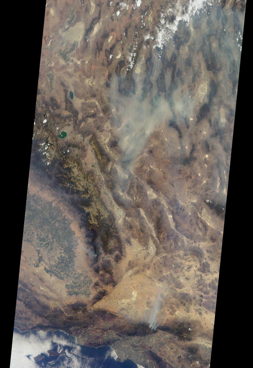
A look at smoke from the Chisholm forest fire, which ignited on May 23, 2001 about 160 kilometers north of Edmonton in Alberta, Canada, as seen by NASA Terra spacecraft.

Ignited by lightning strikes during a record-breaking heat wave, the Biscuit Fire became Oregon largest wildfire of the past century. NASA Terra spacecraft acquired these image between mid July and early September 2002.
jsc2024e053517 (8/8/2024) --- A plexiglass rod burns in microgravity for the Solid Fuel Ignition and Extinction - Material Ignition and Suppression Test (SoFIE-MIST) investigation. Once each rod is ignited, the flame spreads upstream from the ignition end of the rod. As tests progress, the flame spreads along the rod, consuming oxygen. Once the oxygen concentration drops low enough, the flame extinguishes due to natural oxygen depletion. Data to measure the oxygen concentration, flow rate, and heat loss is obtained at the three test pressures. SoFIE-MIST aims to improve understanding of early fire growth behavior and validate models for material flammability, helping to inform the selection of safer materials for future space facilities and determine the best methods for extinguishing fires in space. .
jsc2024e053516 (8/8/2024) --- A plexiglass rod burns in microgravity for the Solid Fuel Ignition and Extinction - Material Ignition and Suppression Test (SoFIE-MIST) investigation. Once each rod is ignited, the flame spreads upstream from the ignition end of the rod. As tests progress, the flame spreads along the rod, consuming oxygen. Once the oxygen concentration drops low enough, the flame extinguishes due to natural oxygen depletion. Data to measure the oxygen concentration, flow rate, and heat loss is obtained at the three test pressures. SoFIE-MIST aims to improve understanding of early fire growth behavior and validate models for material flammability, helping to inform the selection of safer materials for future space facilities and determine the best methods for extinguishing fires in space.
iss067e367893 (Sept. 15, 2022) --- ESA (European Space Agency) astronaut and Expedition 67 Flight Engineer Samantha Cristoforetti works inside the International Space Station's Unity module reconfiguring components for the Solid Fuel Ignition and Extinction investigation that explores fire growth and fire safety techniques in space.
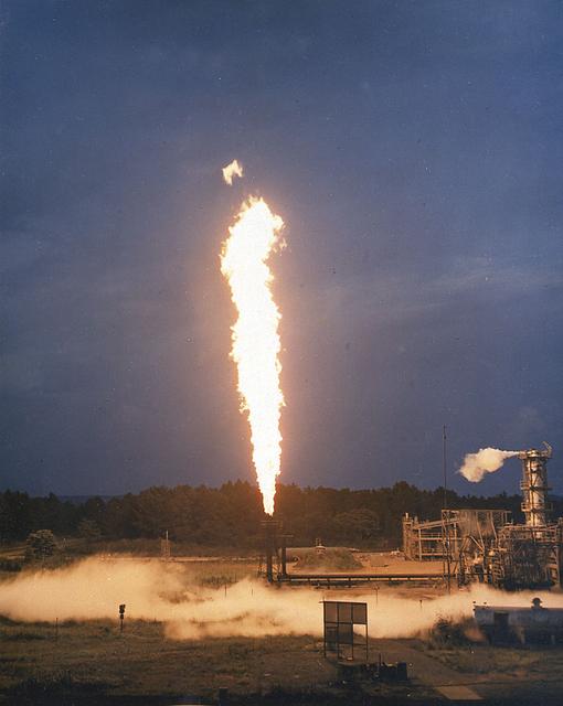
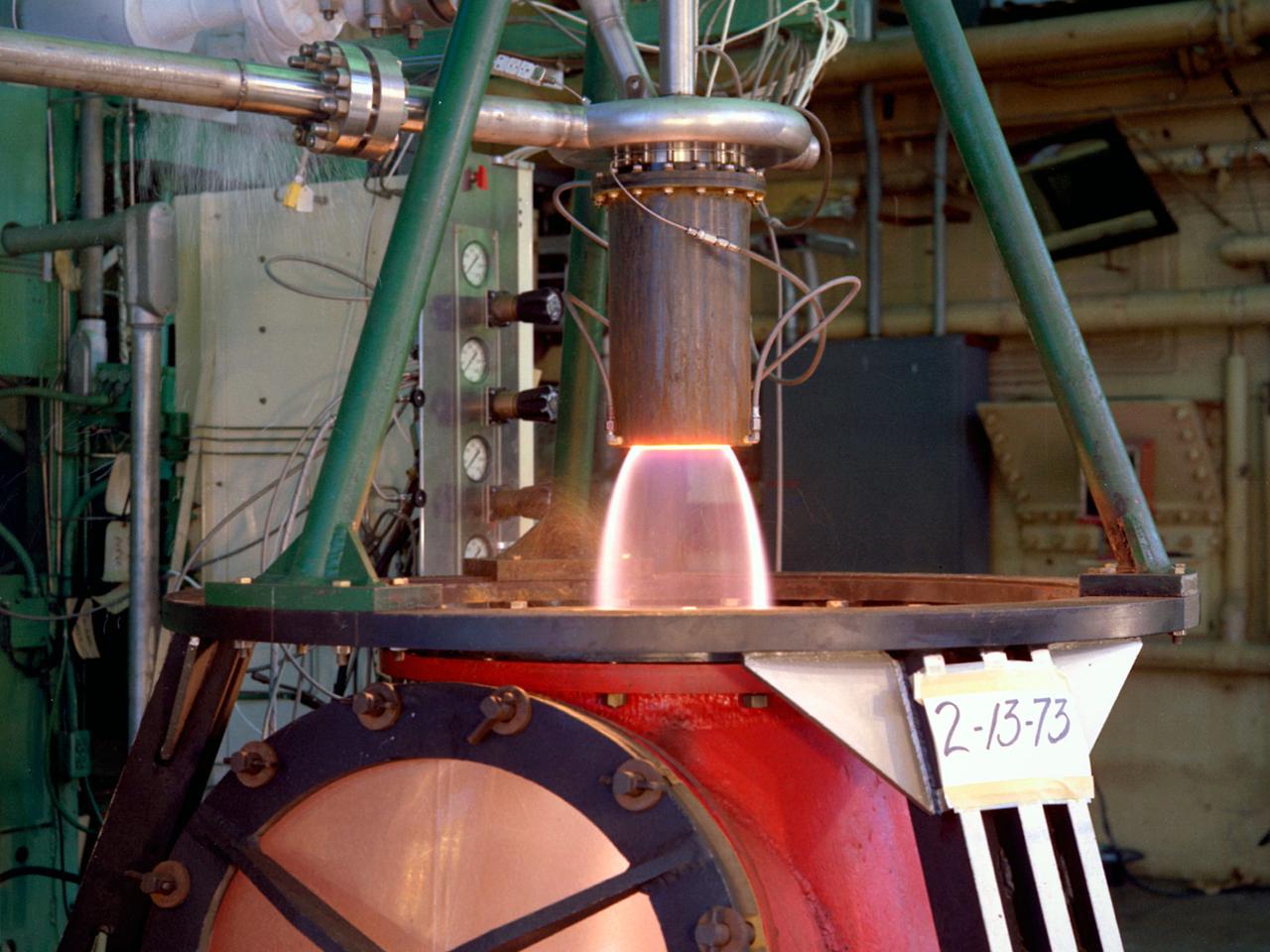
Marshall Space Flight Center's rocket development has always included component testing. Pictured here is a Cell 114-B burn stack. The C114-B is part of the gas generators used to test heat exchanges for the F-1 engine. On the initial firing of the C114-B the spark ignition would not light. The rocket propellant mixed with the liquid oxygen gelled creating a bomb. After several attempts at ignition, the spark ignited and blew up the stand. Subsequent testings were completed on newly constructed stands and no further mishaps were reported.
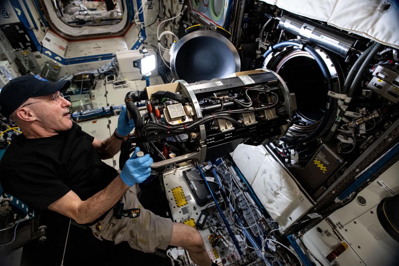
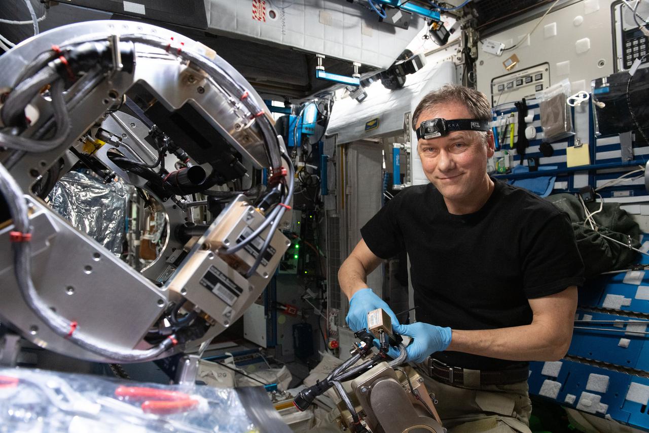
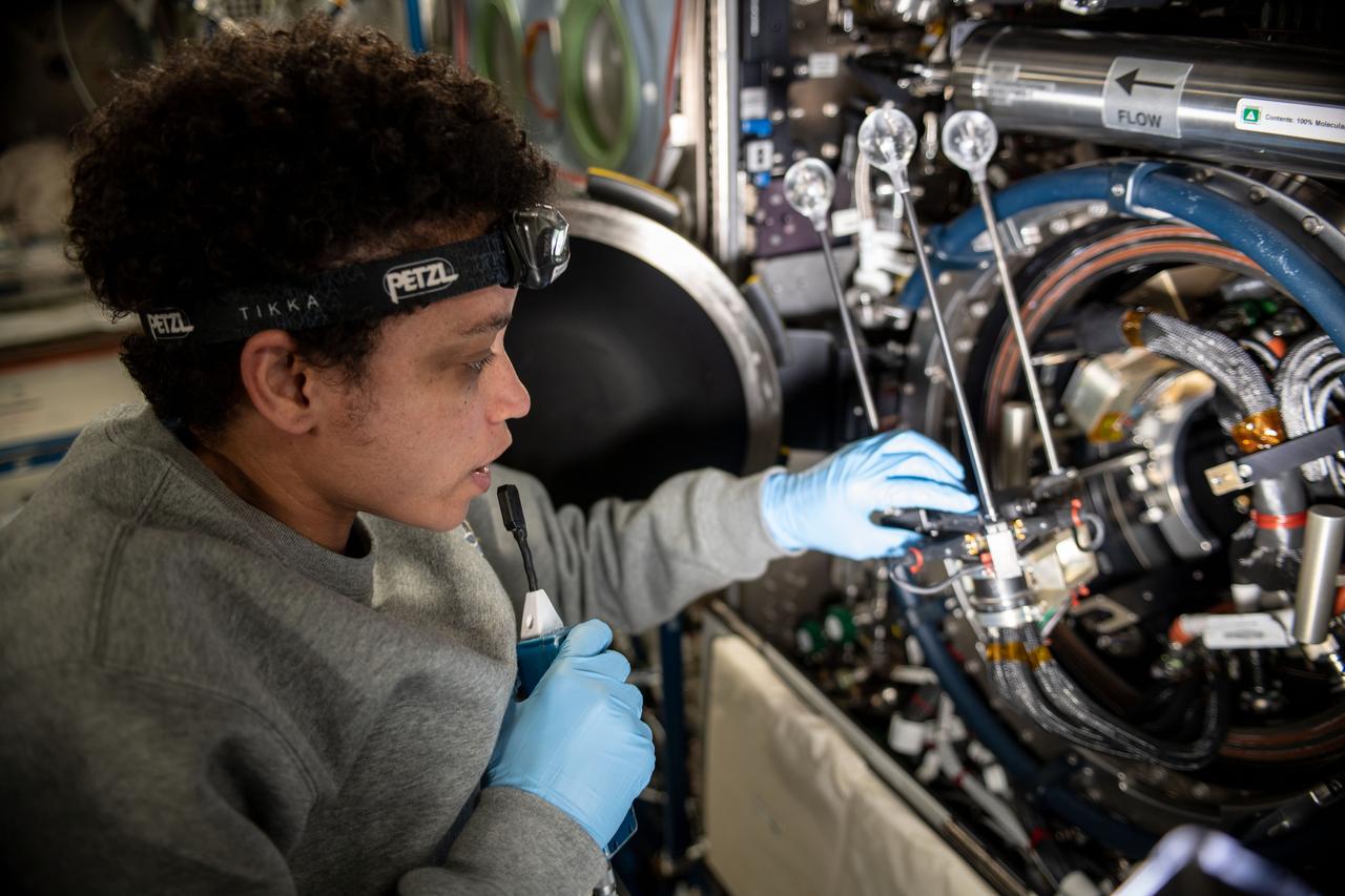
iss072e747154 (March 18, 2025) --- NASA astronaut and Expedition 72 Flight Engineer Don Pettit inserts research hardware into the Combustion Integrated Rack located inside the International Space Station's Destiny laboratory module. Pettit was configuring the SoFIE-MIST, or the Solid Fuel Ignition and Extinction - Material Ignition and Suppression Test, investigation that is exploring the flammability of materials in microgravity to improve spacecraft fire safety.
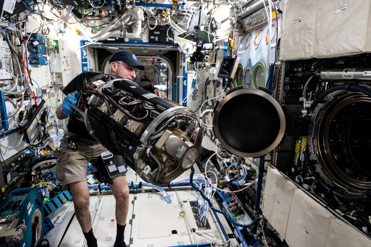
iss072e747148 (March 18, 2025) --- NASA astronaut and Expedition 72 Flight Engineer Don Pettit inserts research hardware into the Combustion Integrated Rack located inside the International Space Station's Destiny laboratory module. Pettit was configuring the SoFIE-MIST, or the Solid Fuel Ignition and Extinction - Material Ignition and Suppression Test, investigation that is exploring the flammability of materials in microgravity to improve spacecraft fire safety.
On Aug. 16, 2016, at around 10:30 a.m., a brush fire ignited in the Cajon Pass east of Los Angeles, just to the west of Interstate 15. Within a matter of hours, extreme temperatures, high winds and low humidity allowed the fire to spread rapidly, burning through brush left tinder-dry by years of drought. Firefighters quickly responded, ordering the evacuation of about 83,000 people in and around the Cajon Pass, Wrightwood, Lytle Creek, Oak Hills and surrounding areas. An as-yet uncounted number of homes and structures have burned, and Interstate 15 remains closed to downed power lines and barrier damage. By Aug. 17, the fire had expanded to more than 30,000 acres and remains zero percent contained as some 1,300 firefighters continue to battle to save homes and evacuate residents. The Multi-angle Imaging SpectroRadiometer (MISR) instrument aboard NASA's Terra satellite passed over the region on Aug. 17 around 11:50 a.m. PDT and captured this natural-color image from MISR's 70-degree forward-viewing camera, which covers an areas about 257 miles (414 kilometers) wide. The oblique view angle makes the smoke more apparent than it would be in a more conventional vertical view. The Los Angeles metropolitan area is the large gray area on the coast in the center of the image. Three plumes from the Blue Cut Fire are clearly visible in the mountains to the north. This oblique view also shows an enormous cloud of smoke spreading northeastward over a significant portion of eastern California and Nevada. This smoke probably originated from the fire as it consumed almost 20,000 acres on the evening of the 16th and traveled north overnight. Also visible from this oblique view is considerable haziness filling California's Central Valley, to the northwest of the Blue Cut Fire. This haziness is most likely due to smoke from several other fires burning in California, including the Soberanes Fire near Monterey, the Clayton Fire that has destroyed 175 structures north of San Francisco, the Chimney Fire and the Cedar Fire, which is visible in the image in the southern Sierra Nevada. The total number of acres burned in California this year has tripled in just the past week. The 3D stereo anaglyph is made by combining data from MISR's 60-degree and 70-degree forward-viewing cameras. You will need red-blue glasses to view the 3D effect (ensure the red lens is over your left eye). In order to enable stereo viewing, the image has been rotated so north is to the left. These data were acquired during Terra orbit 88648. http://photojournal.jpl.nasa.gov/catalog/PIA20888
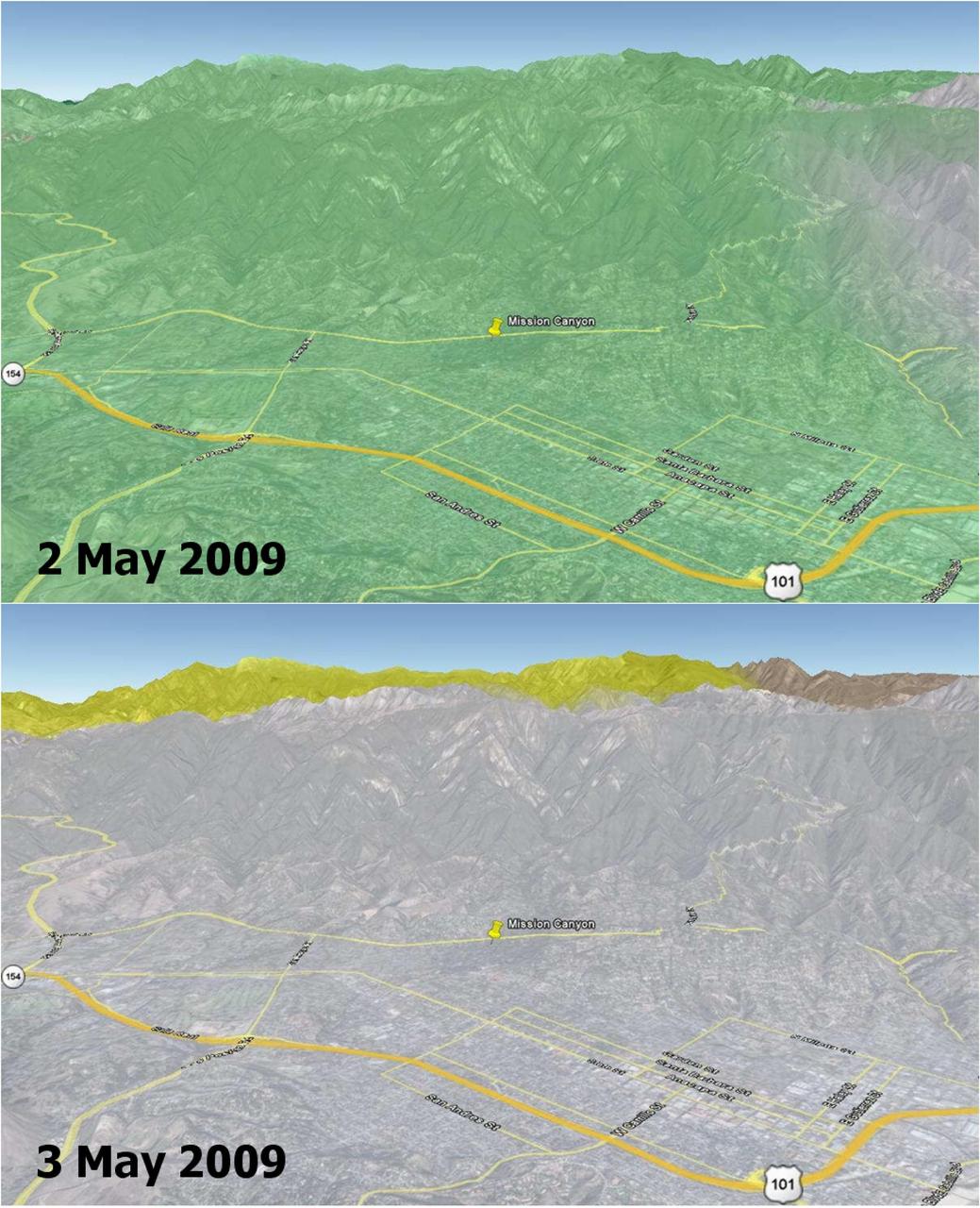
Wildfires are a recurring natural hazard faced by Californians. In Santa Barbara County, a wildfire, called the Jesusita fire, ignited on May 5, 2009 in the Cathedral Peak area northwest of Mission Canyon. As of midday May 8, the fire, which was 10-percent contained, had scorched 3,500 acres, damaged or destroyed 75 structures, and had forced the evacuation of tens of thousands of residents. This image shows soil moisture change in the top soil layer (2-inches deep) on 2 and 3 May 2009, as measured by the NASA QuikSCAT satellite scatterometer (radar). Rainwater increased the amount of moisture in the soil by a moderate 4 percent (represented by the green color) on May 2, which rapidly dried up on the next day (0 percent, as depicted by the grey color on May 3). Son Nghiem of JPL is leading a science team to develop wildfire applications using QuikScat data. “Information critical to assessing the conditions leading to wildfires can be obtained from NASA’s SeaWinds scatterometer, a stable and accurate radar aboard the QuikScat satellite,” says Dr. Son Nghiem, a JPL scientist in remote sensing. This is accomplished by using QuikScat data to map moisture changes in the topsoil. As such, QuikScat can detect rainwater that actually reaches the land surface and accumulates on it, rather than raindrops in the air. While rain radars may detect a significant rain rate, rainwater may evaporate in part before reaching the surface. For example, in the case of dry thunderstorm (known as virga), raindrops disappear on the way down, leaving the land dry, while the associated lightning ignites fires. For the case of the current fire in Santa Barbara, QuikScat detected a moderate increase of 4 percent in soil moisture on May 2, while rain radar data seemed to indicate a significant and extensive rain. The next day, QuikScat revealed that whatever rainwater that had accumulated earlier quickly dried up over the whole area. The maximum temperature in Santa Barbara approached 90 degrees Fahrenheit and broke the record set in 1984. An important characteristic of QuikScat measurements is that they represent the average conditions over the whole area, rather than some disparate data collected at a few localized points. The rapid dry-up in Santa Barbara together with high temperatures and high winds led to the devastating Jesusita fire. http://photojournal.jpl.nasa.gov/catalog/PIA12006

CAPE CANAVERAL, Fla. – Fire Rescue personnel douse a brush fire near Headquarters Building in the Industrial Area of NASA’s Kennedy Space Center in Florida. The fire was ignited by a lightning strike. The space center is nestled on the Merritt Island National Wildlife Refuge, which is managed by the U.S. Fish and Wildlife Service. Chenega Security & Support Solutions is responsible for Kennedy's Fire Rescue Department. For information on the refuge, visit http://www.fws.gov/merrittisland/Index.html. For more on Kennedy Space Center, visit http://www.nasa.gov/kennedy. Photo credit: NASA/Ben Smegelsky
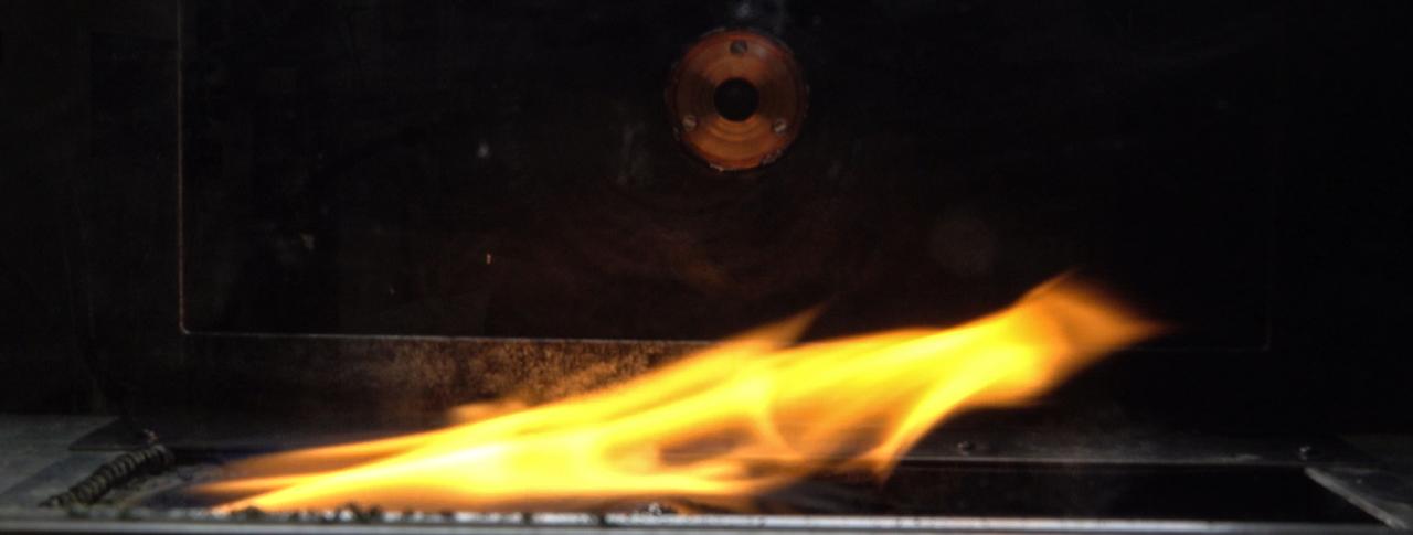
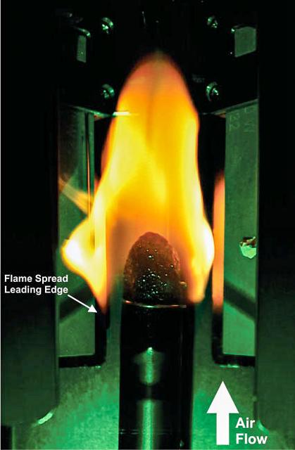
jsc2024e044215 (7/10/2024) --- Side view of spread flame in ground-based test for the Solid Fuel Ignition and Extinction - Oscillatory Flow on Flame Spread (SoFIE-OFFS) investigation. SoFIE-OFFS examines how intermittent or non-steady flame behavior impacts fire spread on Earth. Image courtesy of Worcester Polytechnic Institute.
iss067e003895 (April 6, 2022) --- NASA astronaut and Expedition 67 Commander Thomas Marshburn configures the Combustion Integrated Rack's combustion chamber for the Solid Fuel Ignition and Extinction study to investigate material flammability and ways to improve fire safety in space.
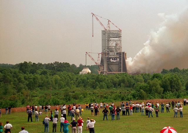
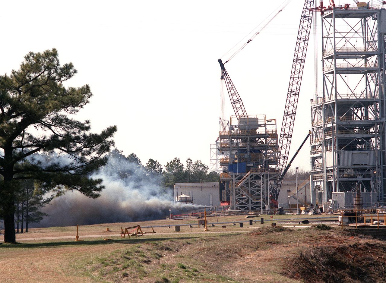
On the 25th Anniversary of the Apollo-11 space launch, Marshall celebrated with a test firing of the Space Shuttle Main Engine at the Technology Test Bed (SSME-TTB). This drew a large crowd who stood in the fields around the test site and watched as plumes of white smoke verified ignition.
iss067e170237 (June 24, 2022) --- Expedition 67 Flight Engineer and NASA astronaut Jessica Watkins services components that support the Solid Fuel Ignition and Extinction (SOFIE) fire safety experiment inside the International Space Station's Combustion Integrated Rack.
iss067e003872 (April 6, 2022) --- NASA astronaut and Expedition 67 Commander Thomas Marshburn configures the Combustion Integrated Rack's combustion chamber for the Solid Fuel Ignition and Extinction study to investigate material flammability and ways to improve fire safety in space.
iss066e139638 (Feb. 10, 2022) --- NASA astronaut and Expedition 66 Flight Engineer Mark Vande Hei configures the Combustion Integrated Rack in the U.S. Destiny laboratory module to support a pair of fire safety experiments known as SoFIE, or Solid Fuel Ignition and Extinction.
iss066e137090 (Feb. 8, 2022) --- NASA astronaut and Expedition 66 Flight Engineer Thomas Marshburn configures the Combustion Integrated Rack to begin operations for a pair of studies exploring fire growth in microgravity. The two SoFIE, or Solid Fuel Ignition and Extinction, studies explore safer, less flammable spacecraft materials as well as fire extinguishing and suppresion techniques in microgravity.
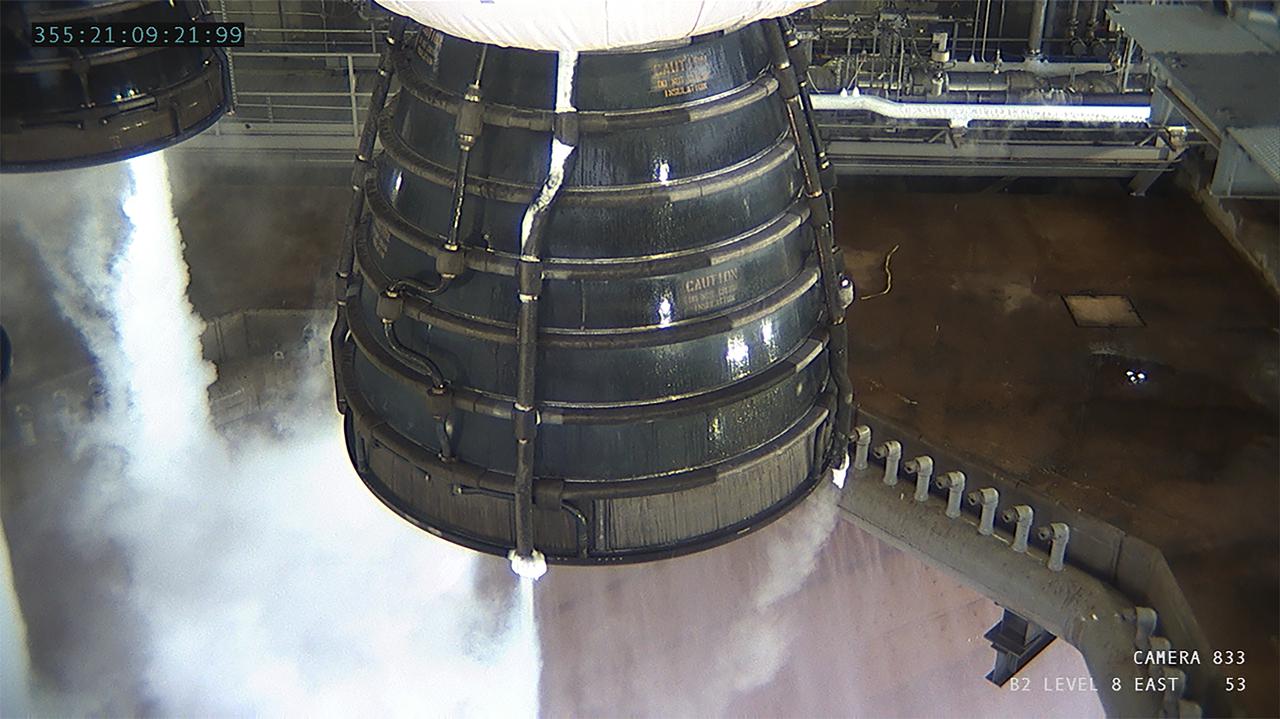
Operators at the B-2 Test Stand at Stennis Space Center near Bay St. Louis, Mississippi, conducted a wet dress rehearsal for the hot fire test of the core stage of NASA’s Space Launch System on Dec. 21, 2020. In this image, liquid oxygen vents from the four RS-25 engines that will ignite during the final hot fire test of the core stage. The hot fire will conclude a series of eight Green Run tests of all core stage systems before it is transported to Kennedy Space Center for launch on the Artemis I mission.
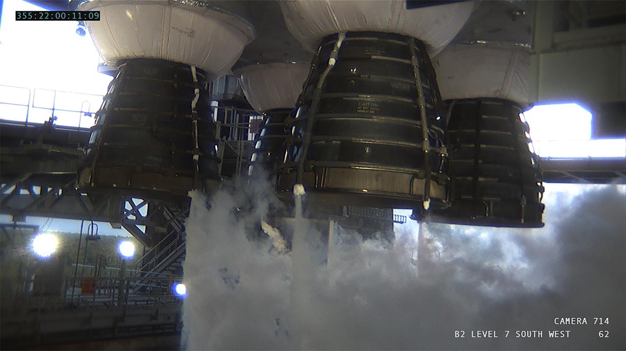
Operators at the B-2 Test Stand at Stennis Space Center near Bay St. Louis, Mississippi, conducted a wet dress rehearsal for the hot fire test of the core stage of NASA’s Space Launch System on Dec. 21, 2020. In this image, liquid oxygen vents from the four RS-25 engines that will ignite during the final hot fire test of the core stage. The hot fire will conclude a series of eight Green Run tests of all core stage systems before it is transported to Kennedy Space Center for launch on the Artemis I mission.
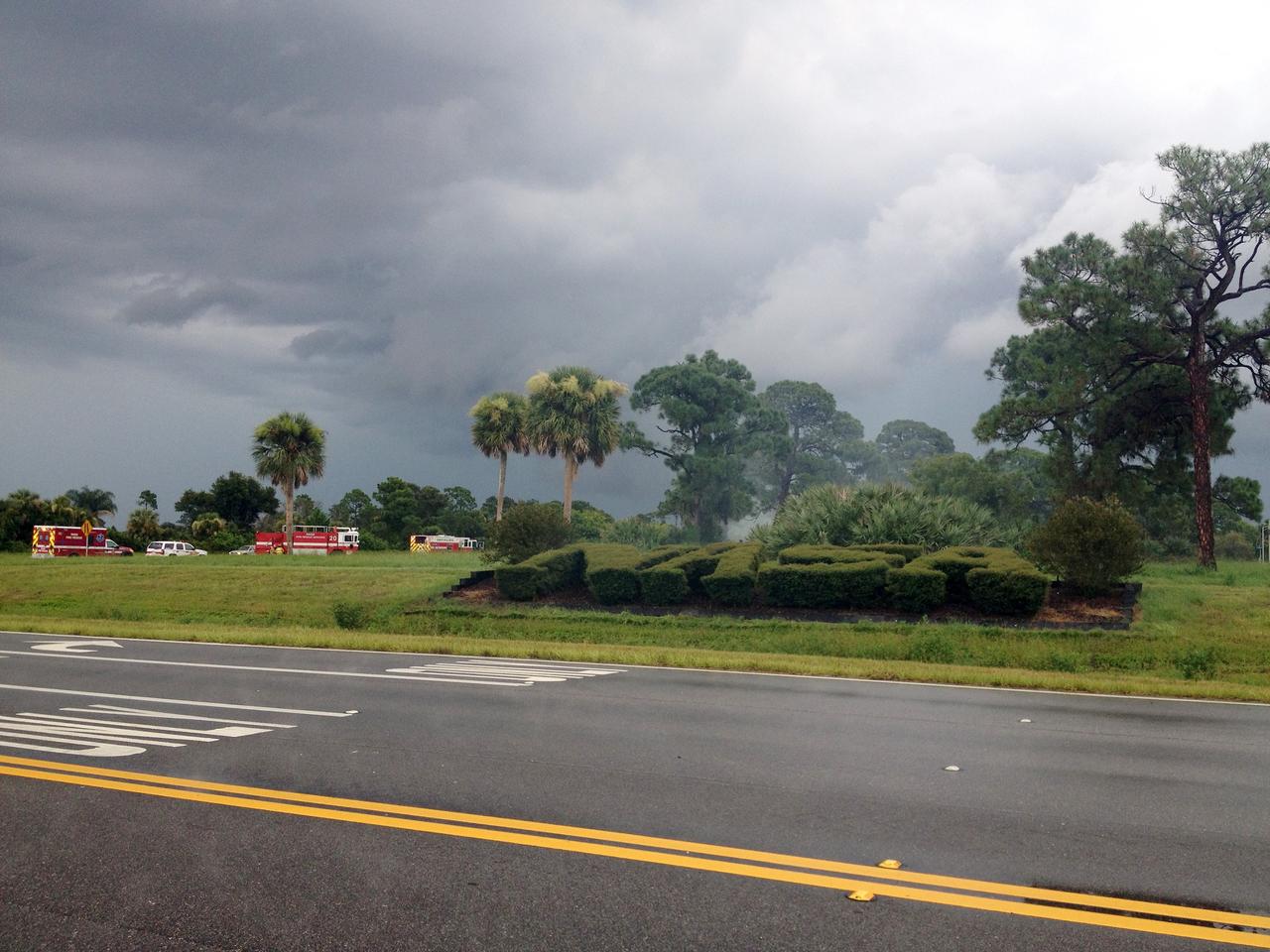
CAPE CANAVERAL, Fla. – Emergency responders are called to the scene of a brush fire near Headquarters Building in the Industrial Area of NASA’s Kennedy Space Center in Florida. The fire was ignited by a lightning strike. The space center is nestled on the Merritt Island National Wildlife Refuge, which is managed by the U.S. Fish and Wildlife Service. Chenega Security & Support Solutions is responsible for Kennedy's Fire Rescue Department. For information on the refuge, visit http://www.fws.gov/merrittisland/Index.html. For more on Kennedy Space Center, visit http://www.nasa.gov/kennedy. Photo credit: NASA/Ben Smegelsky
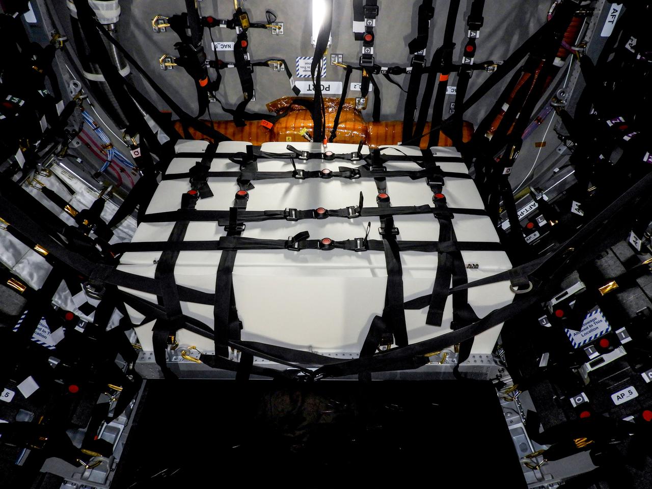
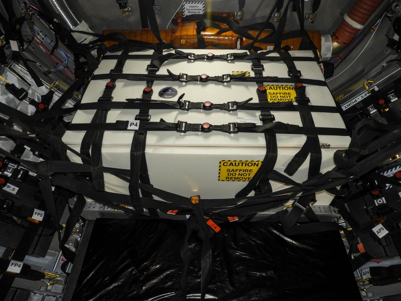
jsc2023e046377 (12/14/2019) --- A view of the Spacecraft Fire Safety Experiments (Saffire) VI experiment hardware, loaded inside the Northrop Grumman (NG) Cygnus cargo vehicle for the 19th NG resupply mission to the International Space Station. Saffire is a series of experiments to investigate how fire spreads on a variety of combustible materials in the microgravity environment. The experiments are ignited in the Cygnus cargo spacecraft after it departs the space station and before it reenters the Earth's atmosphere. Saffire-VI builds on prior results to test flammability at different oxygen levels and aims to further knowledge of realistic flame spread to aid the development of fire safety equipment and strategies for future spacecraft.
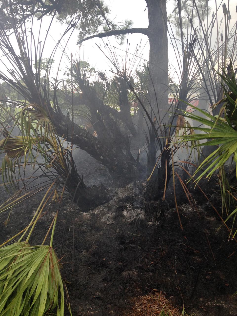
CAPE CANAVERAL, Fla. – A charred palmetto palm remains after a brush fire is extinguished near Headquarters Building in the Industrial Area of NASA’s Kennedy Space Center in Florida. The fire was ignited by a lightning strike. The space center is nestled on the Merritt Island National Wildlife Refuge, which is managed by the U.S. Fish and Wildlife Service. Chenega Security & Support Solutions is responsible for Kennedy's Fire Rescue Department. For information on the refuge, visit http://www.fws.gov/merrittisland/Index.html. For more on Kennedy Space Center, visit http://www.nasa.gov/kennedy. Photo credit: NASA/Ben Smegelsky
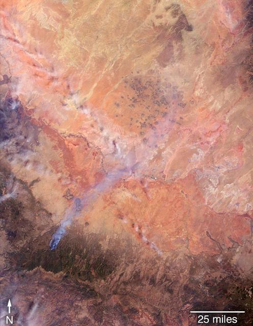
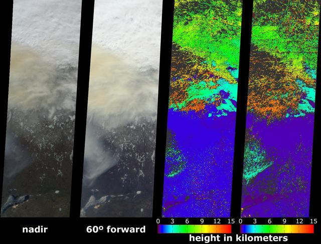
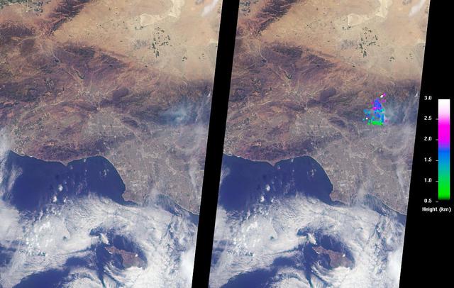
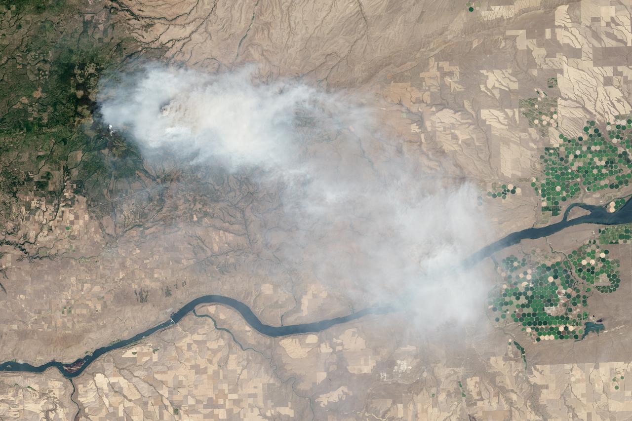
On April 27, 2018, the Tinder Fire ignited in eastern Arizona near the Blue Ridge Reservoir, about 50 miles (80 kilometers) southeast of Flagstaff and 20 miles (32 kilometers) northeast of Payson. During the first 24 hours it remained relatively small at 500 acres (202 hectares), but on April 29, during red flag wind conditions, it exploded to 8,600 acres (3,480 hectares). Residents of rural communities in the area were forced to evacuate and an unknown number of structures were burned. As of April 30, the Tinder Fire had burned a total of 11,400 acres (4,613 hectares). On April 30 at 11:15 a.m. local time, the Multi-angle Imaging SpectroRadiometer (MISR) captured imagery of the Tinder Fire as it passed overhead on NASA's Terra satellite. The MISR instrument has nine cameras that view Earth at different angles. This image shows the view from MISR's nadir (downward-pointing) camera. The angular information from MISR's images is used to calculate the height of the smoke plume, results of which are superimposed on the right-hand image. This shows that the plume top near the active fire was at approximately 13,000 feet altitude (4,000 meters). In general, higher-altitude plumes transport smoke greater distances from the source, impacting communities downwind. A stereo anaglyph providing a three-dimensional view of the plume is also shown. Red-blue glasses with the red lens placed over your left eye are required to observe the 3D effect. These data were acquired during Terra orbit 97691. An annotated figure and anaglyph are available at https://photojournal.jpl.nasa.gov/catalog/PIA00698
STS063-312-020 (3-11 Feb. 1995) --- Astronaut Eileen M. Collins, pilot, at the pilot's station during "hotfiring" procedure to clear leaking thruster prior to rendezvous with Russia's Mir Space Station. Others onboard the Space Shuttle Discovery were astronauts James D. Wetherbee, mission commander; Bernard A. Harris, Jr., payload commander; mission specialists C. Michael Foale and Janice E. Voss, and cosmonaut Vladimir G. Titov. This is one of 16 still photographs released by the NASA Johnson Space Center (JSC) Public Affairs Office (PAO) on February 14, 1995.
jsc2020e043815 (Sept. 10, 2020) --- A view of the Spacecraft Fire Safety Experiments (Saffire) V experiment hardware, loaded inside the Northrop Grumman(NG) Cygnus cargo vehicle for the 14th NG resupply mission to the International Space Station. Saffire is a series of experiments to investigate how fire spreads on a variety of combustible materials in the microgravity environment. The experiments are ignited in Cygnus cargo spacecraft after it departs the space station and before it reenters the Earth's atmosphere. Studying the development and growth of fire in a re-supply cargo vehicle eliminates the risk of exposure to humans in an occupied spacecraft. Understanding how fire behaves in microgravity, and how different materials propagate flames in space is immensely important for the development of future crew spacecraft.
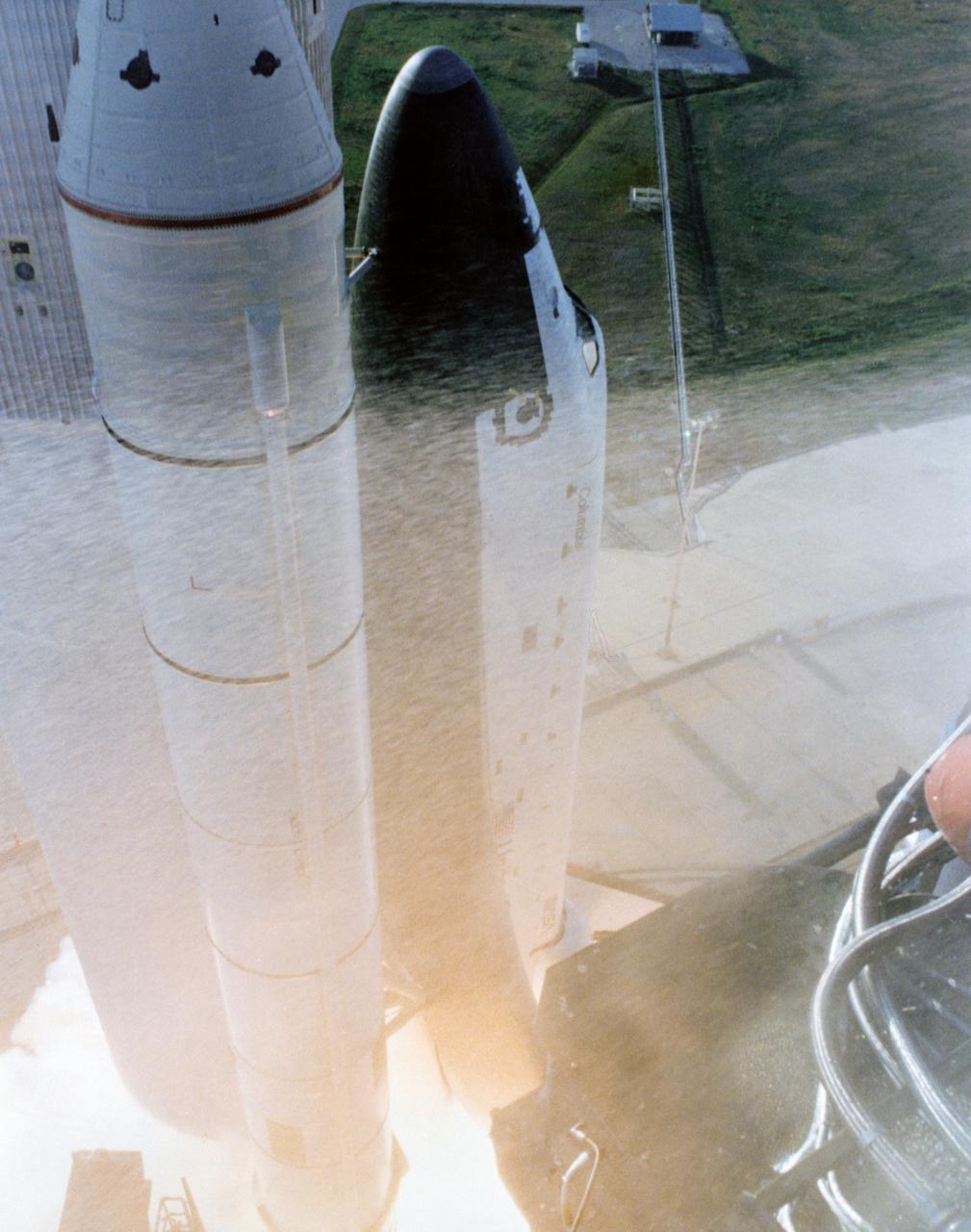
S81-30501 (12 April 1981) --- Nose pointed skyward, space shuttle Columbia begins its climb toward orbit moments after solid rocket booster ignition in this first view of a dramatic liftoff sequence photographed from the 275-feet level of the Fixed Service Structure on Pad 39A. The seven frame sequence documenting the space shuttle’s historic launch on its maiden voyage was taken with a Nikon camera equipped with a 28mm lens with a 250 exposure back. The camera was protected in a fire box. Photo credit: NASA
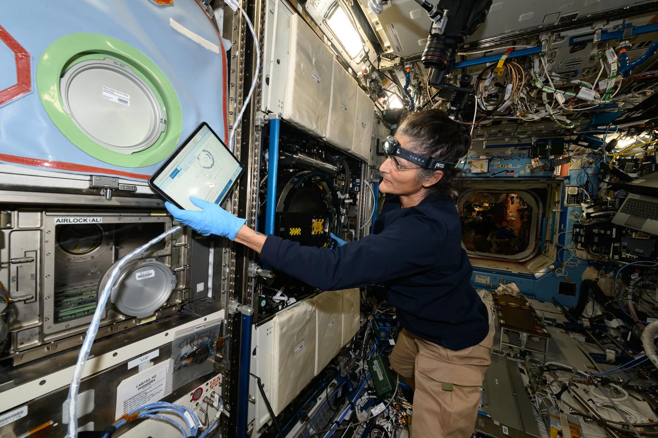
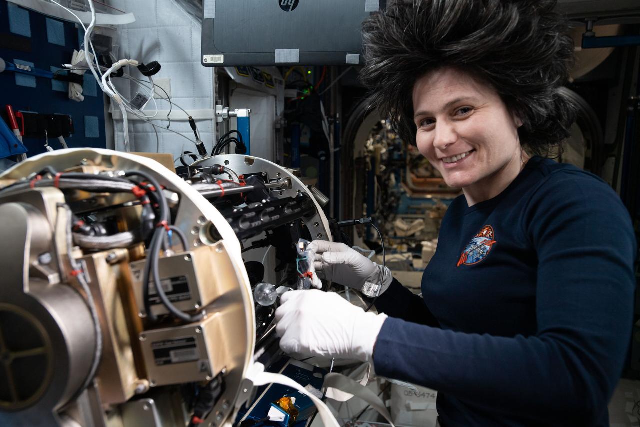
iss072e014350 (Oct. 4, 2024) --- NASA astronaut and Expedition 72 Commander Suni Williams checks procedures on a computer tablet while installing experiment samples inside the International Space Station's Combustion Integrated Rack. Williams was conducting research operations for the Solid Fuel Ignition and Extinction experiment that explores how a variety of materials burn in weightlessness to improve fire safety on spacecraft.
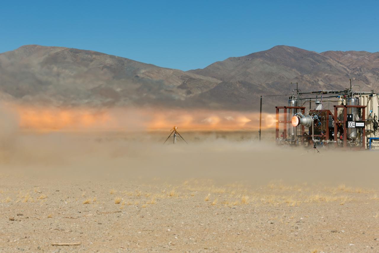
A launch abort engine built by Aerojet Rocketdyne is hot-fired during tests in the Mojave Desert in California. The engine produces up to 40,000 pounds of thrust and burns hypergolic propellants. The engines have been designed and built for use on Boeing’s CST-100 Starliner spacecraft in sets of four. In an emergency at the pad or during ascent, the engines would ignite to push the Starliner and its crew out of danger.
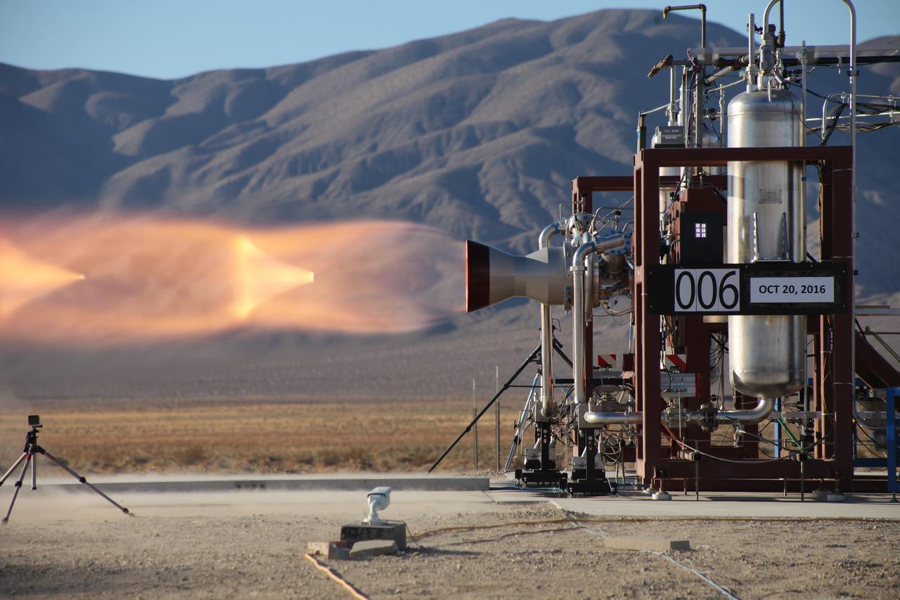
A launch abort engine built by Aerojet Rocketdyne is hot-fired during tests in the Mojave Desert in California. The engine produces up to 40,000 pounds of thrust and burns hypergolic propellants. The engines have been designed and built for use on Boeing’s CST-100 Starliner spacecraft in sets of four. In an emergency at the pad or during ascent, the engines would ignite to push the Starliner and its crew out of danger.
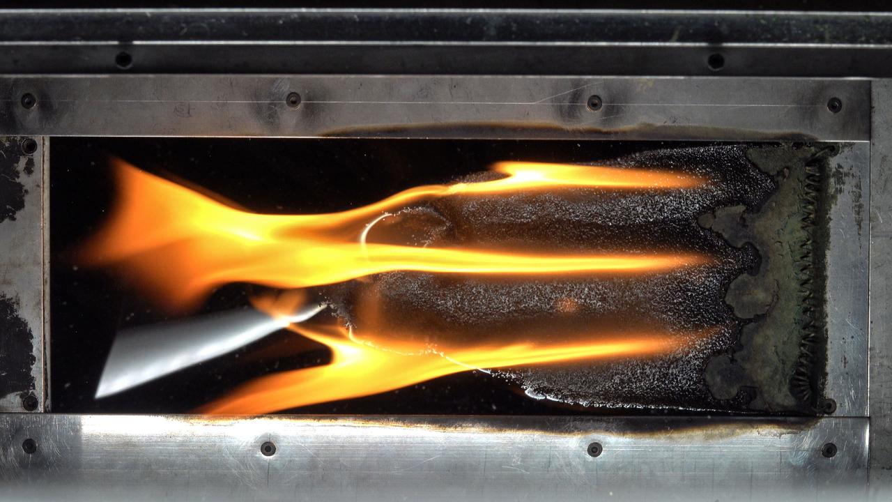
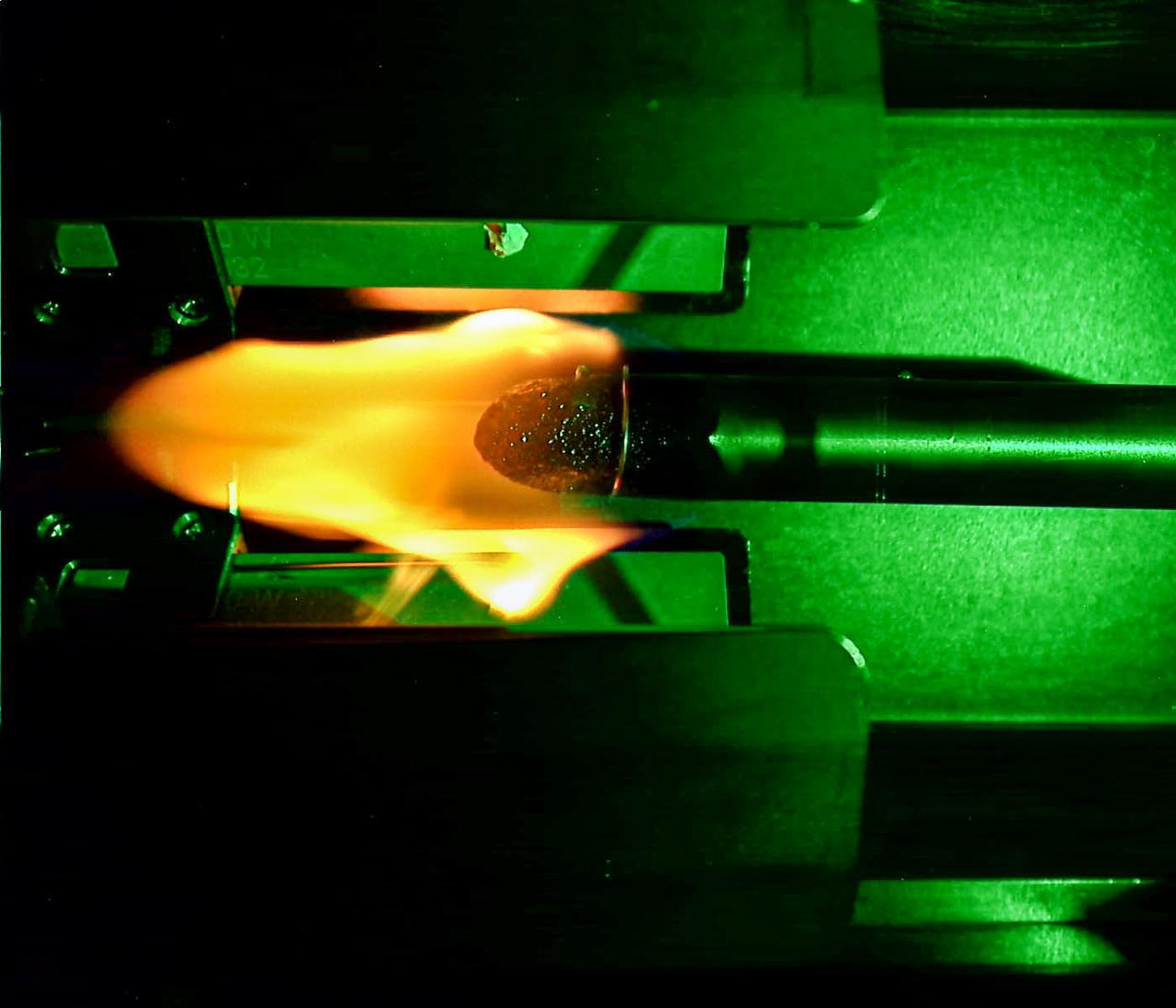
jsc2024e044216 (7/10/2024) --- Top view of spreading flame in ground-based test for the Solid Fuel Ignition and Extinction - Oscillatory Flow on Flame Spread (SoFIE-OFFS) investigation. SoFIE-OFFS examines how intermittent or non-steady flame s behavior impacts fire spread on Earth. Image courtesy of Worcester Polytechnic Institute.
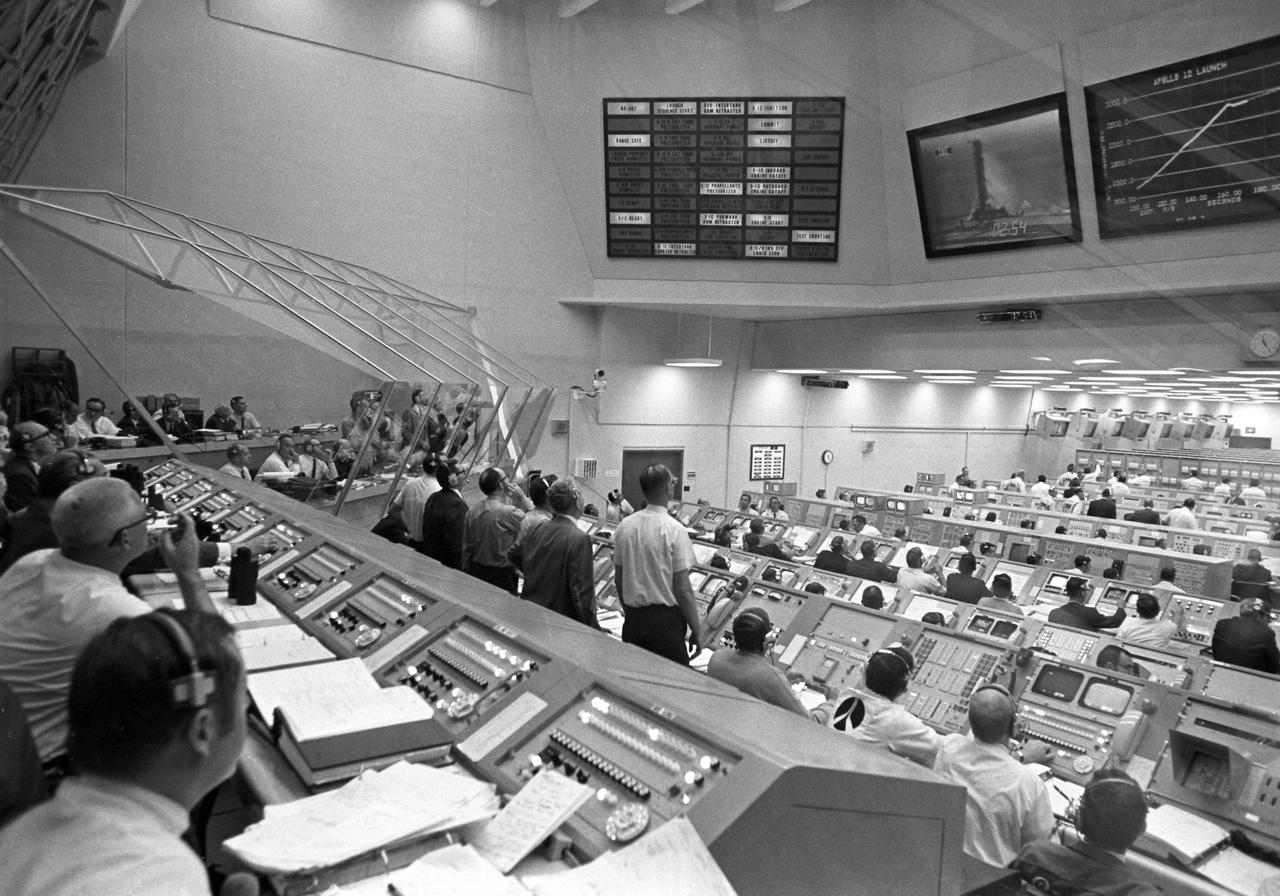
CAPE CANAVERAL, Fla. -- Personnel within Firing Room 2 of the LCC follow the early moments of the Apollo 12 launch on their overhead data display boards. When this view was taken, the vehicle’s second stage engines had ignited, carrying the Apollo 12 spacecraft to an altitude of more than 229,000 feet and more that 50 miles downrange. Photo credit: NASA
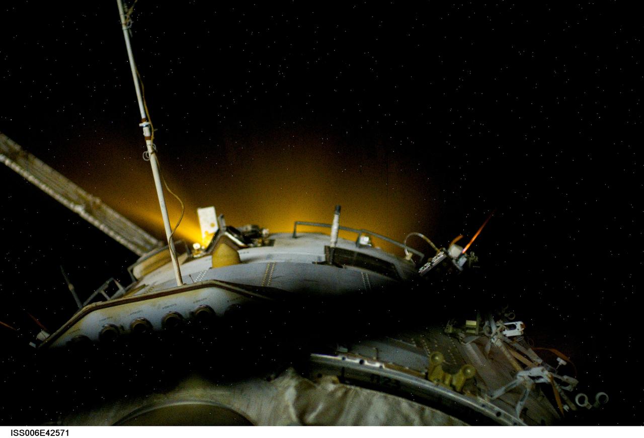
ISS006-E-42571 (4 April 2003) --- This view features a reboost of the International Space Station (ISS) in action. Ground controllers at Mission Control Moscow ignited the thrusters of a Progress rocket docked to the station’s Zvezda Service Module. The 14-minute firing raised the average altitude of the station by about 3 km. One of the Expedition 6 crewmembers captured this picture of the yellow-glowing thrusters from a window in the Service Module.
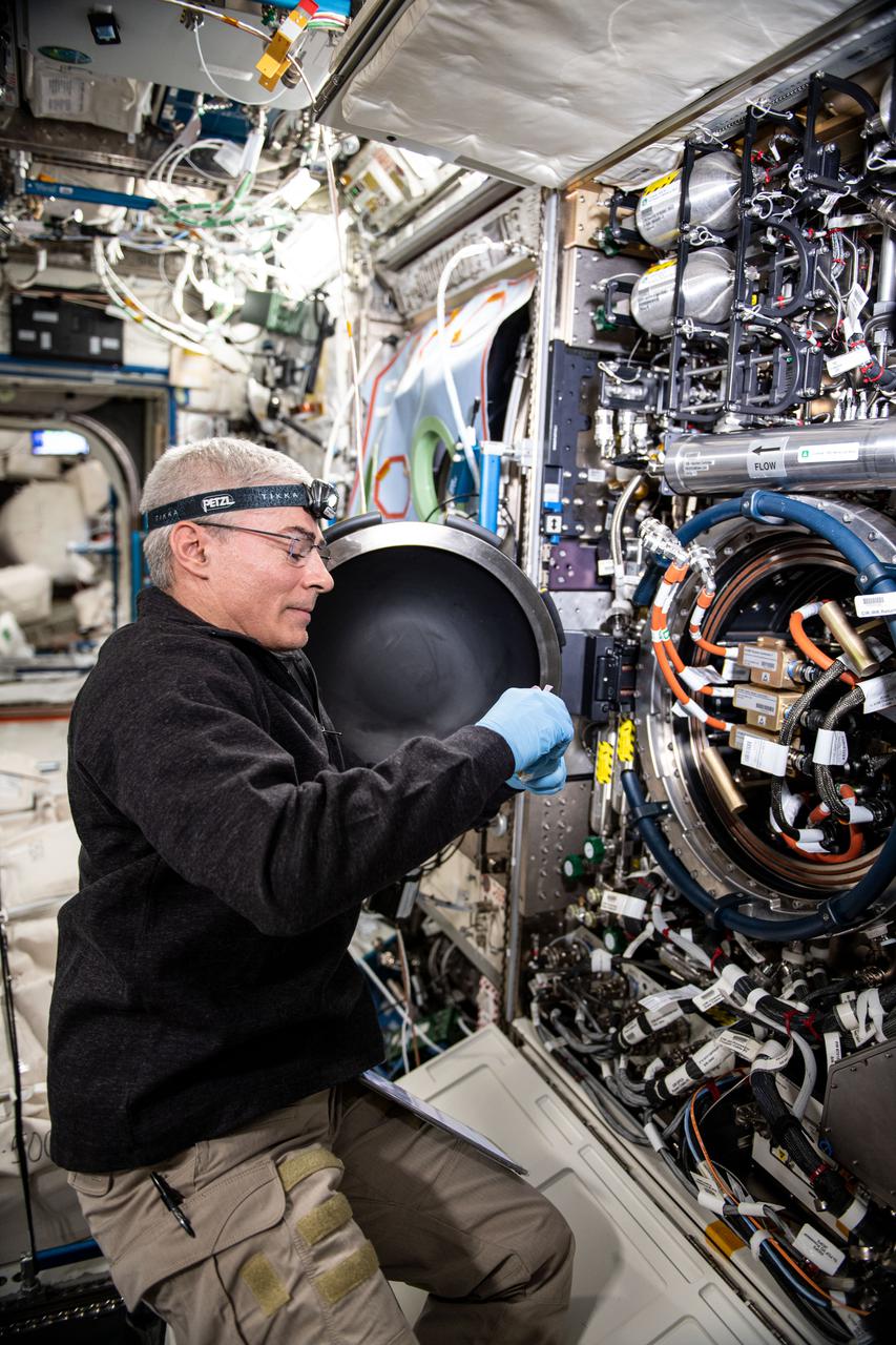
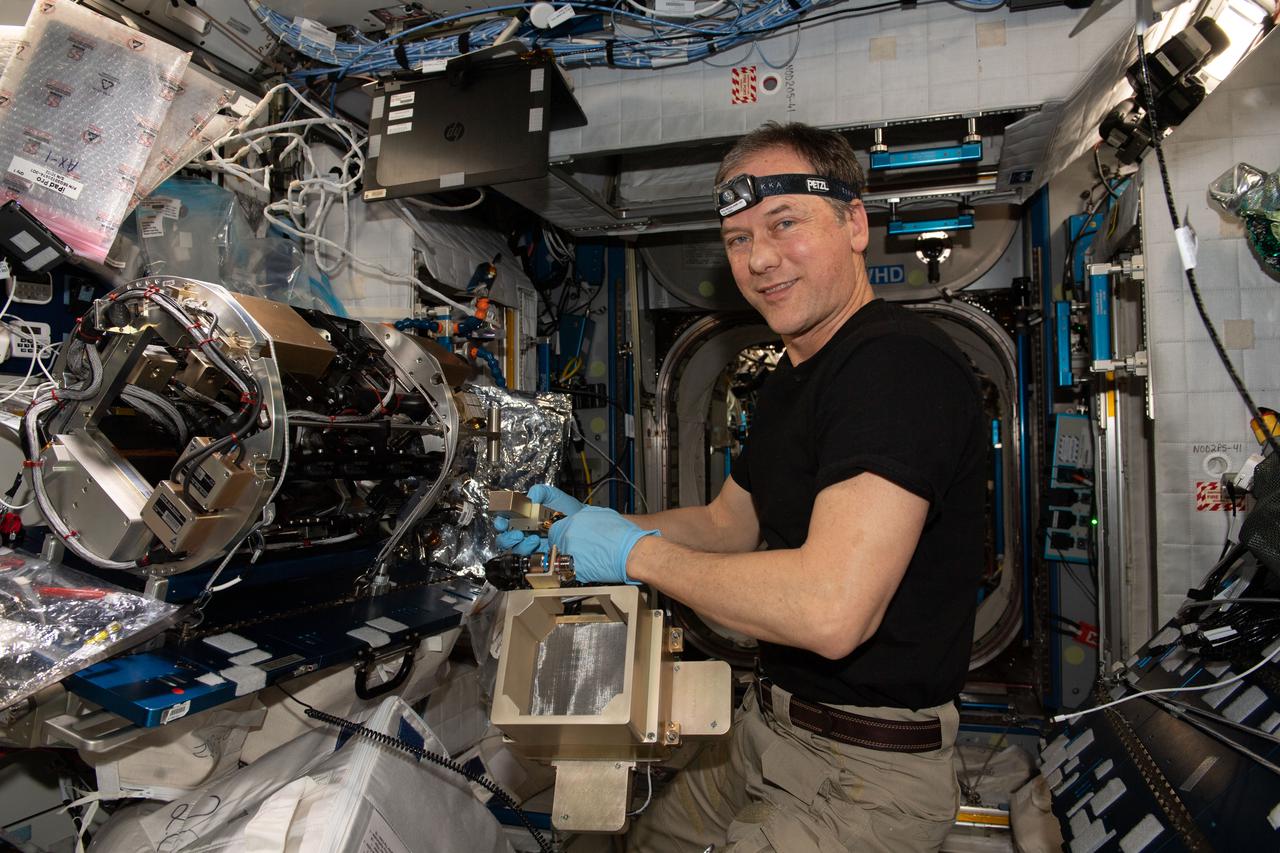
iss065e369687 (Sept. 8, 2021) ----NASA astronaut and Expedition 65 Flight Engineer Mark Vande Hei replaces an igniter inside the U.S. Destiny laboratory module's Combustion Integrated Rack for the ACME series of space combustion studies. ACME, or the Advanced Combustion via Microgravity Experiments, is a set of six independent studies of gaseous flames that seeks to improve fuel efficiency and reduce pollutants on Earth, and improve spacecraft fire prevention by focusing on decreasing the flammability of materials.
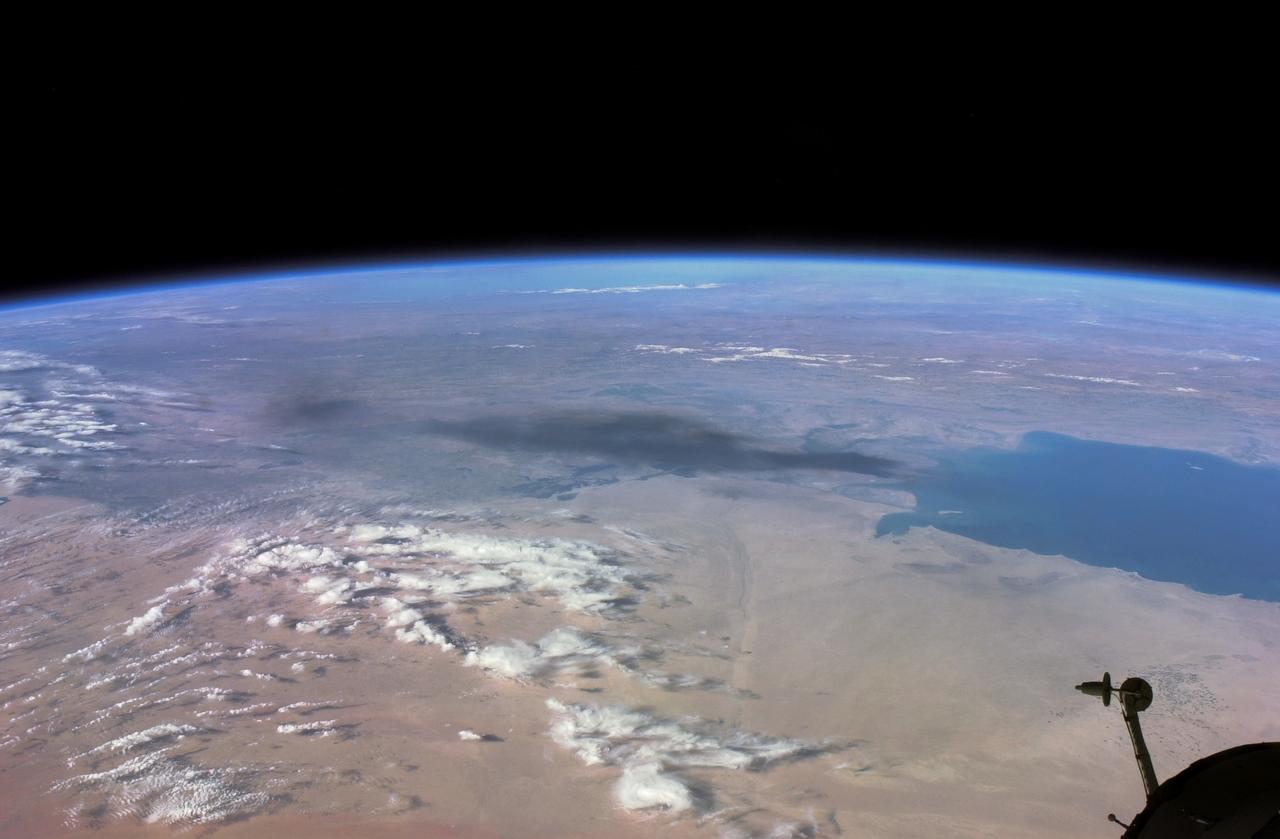
ISS008-E-18935 (24 March 2004) --- This photo of a large black smoke plume from an oil fire was taken by an Expedition 8 crewmember on the International Space Station as the Station orbited northeastward across Saudi Arabia. According to a front-page story in the New York Times, an oil pipeline near the channel of Shatt al Arab in southeastern Iraq on the Persian Gulf ruptured the day before. The resulting oil spill ignited and its smoke can here be seen to extend over 100 miles northwestward into southern Iraq.

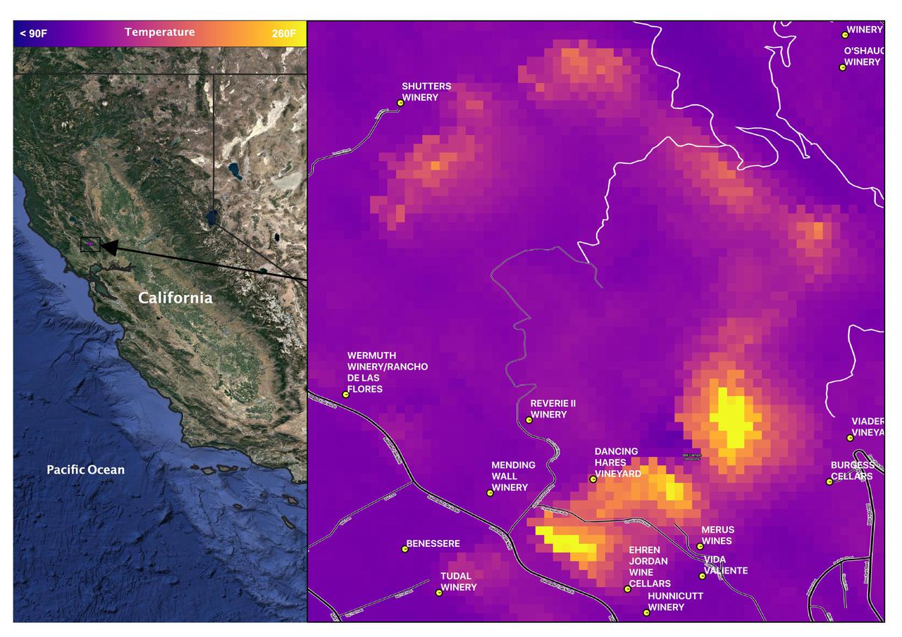
Data from NASA's ECOSTRESS (Ecosystem Spaceborne Thermal Radiometer Experiment on Space Station) instrument aboard the International Space Station shows three wildfires burning in the mountains east and southeast of the Los Angeles area on Sept. 10, 2024. The Bridge Fire started Sept. 8 in the Angeles National Forest during an intense heat wave that blanketed the area for about a week. As of Sept. 13, the fire was only 3% contained. The Line Fire started Sept. 5 in Highland, within San Bernardino County, and spread toward the mountain communities of Running Springs and Big Bear. After more than a week of battling the blaze, firefighters had the conflagration 21% contained. The Airport Fire ignited Sept. 9 in the foothills of the Santa Ana Mountains east of the Orange County city of Irvine and spread into Riverside County. As of Sept. 13, it was 8% contained. The ECOSTRESS instrument measures the temperature of the land rather than air temperatures that most people are familiar with in weather forecasts. Bright white spots in the active fire areas in the visual above indicate a land surface temperature of over 300 degrees Fahrenheit (149 degrees Celsius). Dark red represents areas closer to 100 F (38 C). https://photojournal.jpl.nasa.gov/catalog/PIA26187
STS064-08-032 (10 Sept. 1994) --- At the commander's station on the space shuttle Discovery's forward flight deck, astronaut Richard N. Richards, STS-64 mission commander, initiates a thruster firing of the spacecraft during operations with the Shuttle Plume Impingement Flight Experiment (SPIFEX). Photo credit: NASA or National Aeronautics and Space Administration
STS035-35-007 (2-10 Dec 1990) --- During the STS-35 mission, the Astronomy Laboratory 1 (ASTRO-1) payload, in its on-orbit operating configuration in the payload bay (PLB), is silhouetted against the firing of a reaction control system (RCS) jet. In the center of the frame, three ultraviolet telescopes are mounted and precisely co-aligned on a common structure, called the cruciform, that is attached to the instrument pointing system (IPS). Visible on the cruciform are Integrated Radiator System (IRS) (silver box on left), the Optical Sensor Package (OSP) (above IRS), the Ultraviolet Imaging Telescope (UIT), and the star tracker (S TRK) (far right). A right RCS jet is fired during this maneuver of Columbia, Orbiter Vehicle (OV) 102.
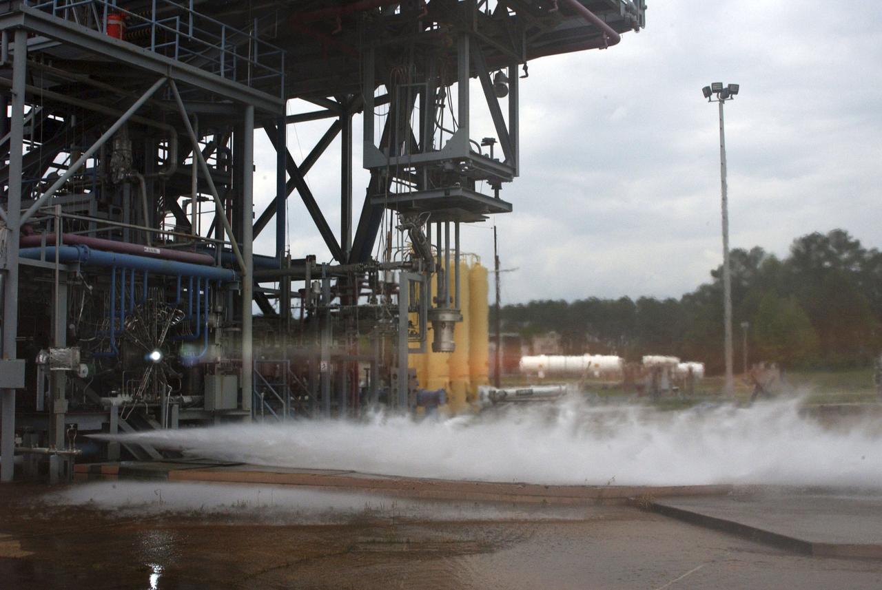
The first hot-fire test of the J-2X power pack 1A gas generator was performed Jan. 31 on the A-1 Test Stand at Stennis Space Center. Initial indications are that all test objectives were met. The test was designed as a 3.42-second helium spin start with gas generator ignition and it went the full scheduled duration. Test conductors reported a smooth start with normal shutdown and described the event as a 'good test.' The test was part of the early component testing for the new J-2X engine being built by NASA to power the Ares I and Ares V rockets that will carry humans back to the moon and on to Mars. It was performed as one in a series of 12 scheduled tests. Those tests began last November at Stennis, but the January 31 event represented the first hot-fire test. The Stennis tests are a critical step in the successful development of the J-2X engine.
Chosen to power the upper stages of the new Ares I Crew Launch Vehicle (CLV) and the Ares V cargo segment, the J-2X engine is a stepped up version of the hydrogen/oxygen-fuelled Apollo-era J-2 engine. It was developed for NASA by Pratt & Whitney Rocketdyne (PWR), a business unit of United Technologies Corporation of Canoga Park, California. As seen in this photograph, the engine underwent a series of hot fire tests, performed on sub scale main injector hardware in the Test Stand 116 at Marshall Space Flight Center (MSFC). The injector is a major component of the engine that injects and mixes propellants in the combustion chamber, where they are ignited and burned to produce thrust.
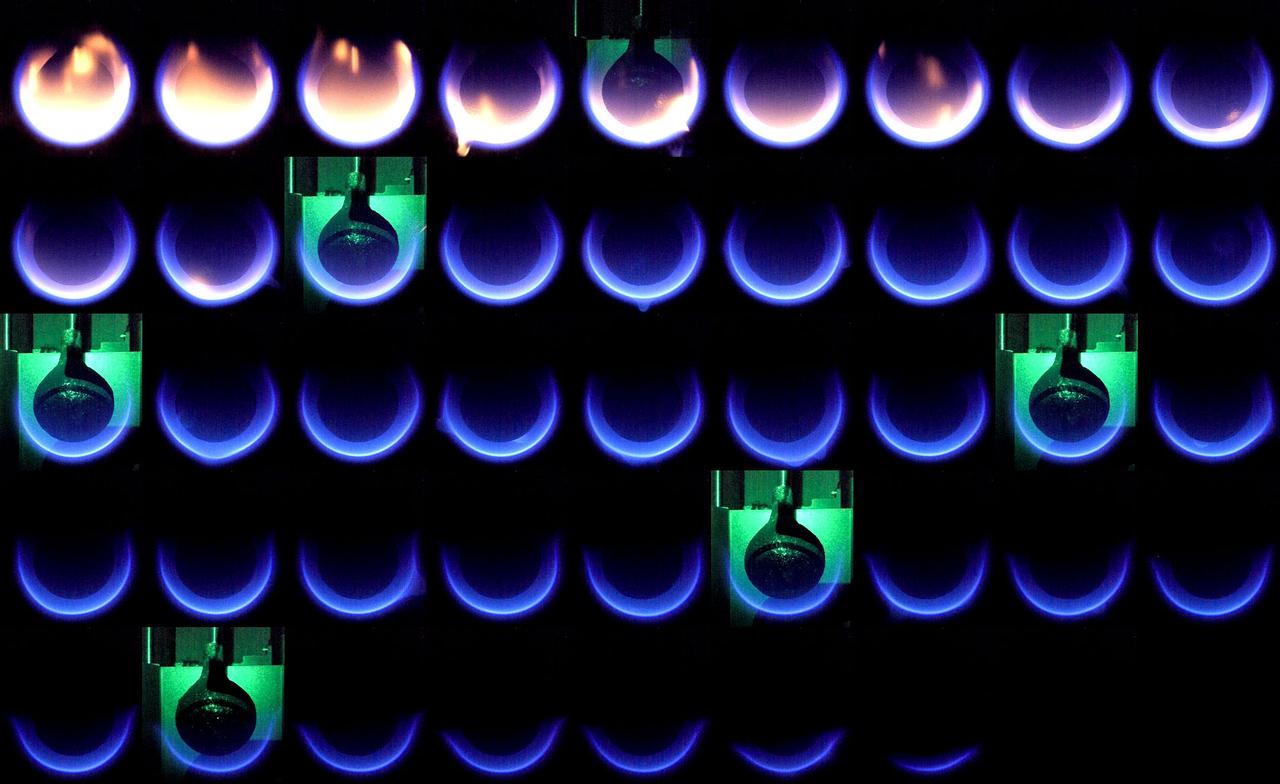
jsc2023e013681 (3/9/2023) --- The Solid Fuel Ignition and Extinction (SoFIE) Growth and Extinction Limits (GEL) experiment aboard the International Space Station (ISS) studies flame growth and extinction in an effort to improve fire safety in space. This image shows a sequence of snapshots taken about 3 seconds apart. During this test point, the ambient oxygen concentration starts relatively high (28%). Initially, the flame is seen as yellow and sooty. As the ambient pressure is reduced, the flame becomes bluer and continues to shrink until fully extinguished. This gives researchers pressure limit data points for flame extinction that could help improve crew and spacecraft safety for future exploration missions.
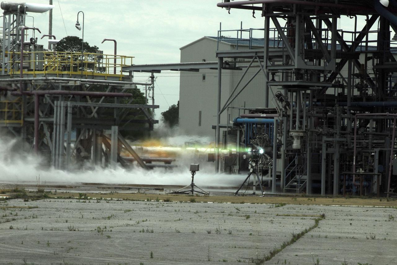
Chosen to power the upper stages of the new Ares I Crew Launch Vehicle (CLV) and the Ares V cargo segment, the J-2X engine is a stepped up version of the hydrogen/oxygen-fuelled Apollo-era J-2 engine. It was developed for NASA by Pratt & Whitney Rocketdyne (PWR), a business unit of United Technologies Corporation of Canoga Park, California. As seen in this photograph, the engine underwent a series of hot fire tests, performed on sub scale main injector hardware in the Test Stand 116 at Marshall Space Flight Center (MSFC). The injector is a major component of the engine that injects and mixes propellants in the combustion chamber, where they are ignited and burned to produce thrust.
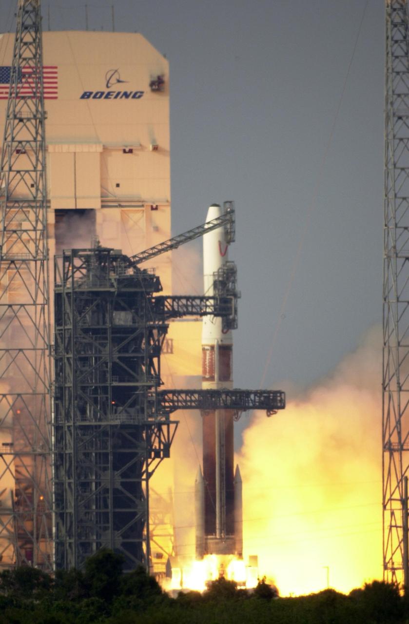
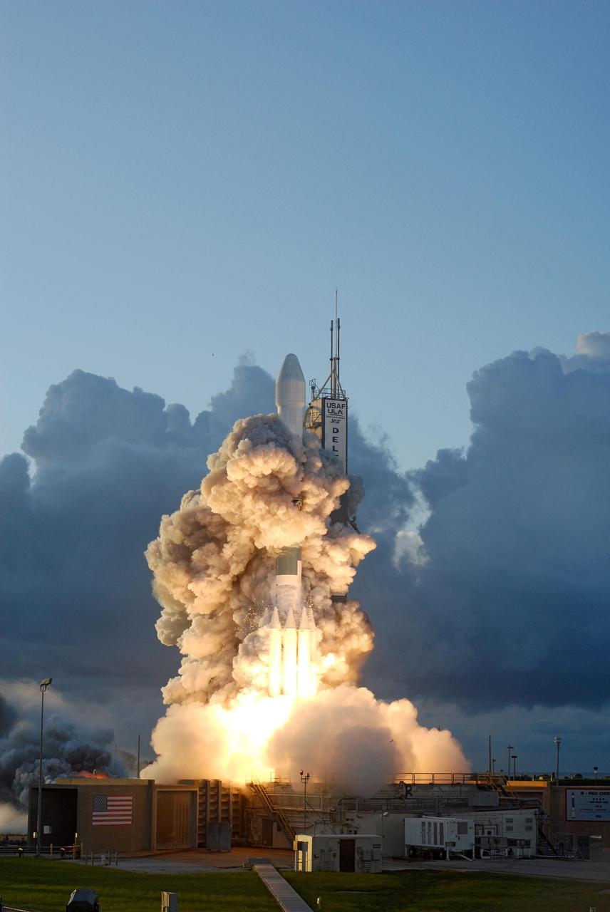
KENNEDY SPACE CENTER, FLA. - Amid fire and smoke, the Boeing Delta IV rocket roars into life after ignition to lift the GOES-N satellite on top into space. Liftoff from Launch Complex 37 at Cape Canaveral Air Force Station was on time at 6:11 p.m. EDT. GOES-N is the latest in the Earth-monitoring series of Geostationary Operational Environmental Satellites developed by NASA and the National Oceanic and Atmospheric Administration. By maintaining a stationary orbit, hovering over one position on the Earth's surface, GOES will be able to provide a constant vigil for the atmospheric "triggers" for severe weather conditions such as tornadoes, flash floods, hail storms and hurricanes. Photo credit: NASA/Ken Thornsley
Late in the evening on September 27, 2020 the Glass Fire ignited in the foothills of Napa Valley, California. The cause of the fire is still unknown. Within 24 hours it exploded to over 11,000 acres fueled by dehydrated soil and the drought-stricken landscape. Within hours of the start of the fire, ECOSTRESS captured several hotspots near the fire's origin (represented by the brightest yellow spots on the map). Not only is it important to monitor the progress of the fire as it to help protect people and property, dense wildfire smoke can also damage crops. For this reason, it is important to track both the movement of the fire and local weather patterns to predict crop damage from smoke exposure. Wildfires are common in this region of California, however this unseasonable fire ripped through the region with unusual speed and intensity. As wildfire behavior continues to adapt with Climate Change, images like this help scientists and farmers understand the impacts that the new fire season has on crops. This information is helpful in developing plans to increase agricultural resilience to climate change. Tasked with detecting plant water use and stress, ECOSTRESS's primary mission is to measure the temperature of plants heating up as they run out of water. But it can also measure and track heat-related phenomena like wildfires, heat waves, and volcanoes. ECOSTRESS observations have a spatial resolution of about 77 by 77 yards (70 by 70 meters), which enables researchers to study surface-temperature conditions down to the size of a football field. Due to the space station's unique orbit, the mission can acquire images of the same regions at different times of the day, as opposed to crossing over each area at the same time of day like satellites in other orbits do. This is advantageous when monitoring plant stress in the same area throughout the day, for example. https://photojournal.jpl.nasa.gov/catalog/PIA24209

California has been hit hard the past few weeks with storms. Storms bring lightning and lightning strikes cause wildfires. Currently there are at least five fire complexes in the area including River, Fork, South, Route and Mad River. The Mad River complex is a series of seven lightning fires that started on July 30th, 2015 after a lightning storm moved through Northern California. After initial firefighters responded, 25 fires were reported and most of the fires were contained. Some additional fires might be detected from the original lightning storms in the upcoming days and will be attacked once they are found. Damage assessment is ongoing and crews will determine the extent of structures and equipment damaged or destroyed. The River Complex is managing a total of 5 fires due to fires merging together on the Shasta-Trinity and the Six Rivers National Forests. Winds from the west are expected to lift the inversion today resulting in active fire behavior. The Fork Complex consists of over 40 fires, all of which were ignited by lightning between July 29 and 31, 2015. These fires are still being identified, assessed, and prioritized. Updated acreage and information about specific fires will be published as it is known. Fire activity moderated throughout last night (8/4) with the smoke inversion layer remaining in place today. Hopefully this will create favorable conditions for fire crews to take direct fire attack on the fires edge, construct dozer line and scout for best firefighting locations on all fires in the complex. The South Complex consists of approximately nine known fires, five of which are currently over 100 acres. The fires are active and defense of structures and point protection are in progress. The weather is trapping smoke in the valley causing very poor air quality. As the smoke lifts the fire activity increases. Firefighters will continue to provide point protection on structures and to look for opportunities to build direct and indirect containment lines. The Route Complex currently stands at 12,164 acres from seven separate fires and is at 2% containment. The overall acreage has been reduced because the South Fire on the nearby South Complex is merging with the Johnson Fire in the Route Complex resulting in decreased and revised fire perimeter acreage. This natural-color satellite image collected by the Moderate Resolution Imaging Spectroradiometer (MODIS) aboard the Terra satellite shows smoke rising and drifting northwest from the various fire complexes. It was captured on August 04, 2015. Actively burning areas, detected by MODIS’s thermal bands, are outlined in red. NASA image courtesy Jeff Schmaltz, MODIS Rapid Response Team. <b><a href="http://www.nasa.gov/audience/formedia/features/MP_Photo_Guidelines.html" rel="nofollow">NASA image use policy.</a></b> <b><a href="http://www.nasa.gov/centers/goddard/home/index.html" rel="nofollow">NASA Goddard Space Flight Center</a></b> enables NASA’s mission through four scientific endeavors: Earth Science, Heliophysics, Solar System Exploration, and Astrophysics. Goddard plays a leading role in NASA’s accomplishments by contributing compelling scientific knowledge to advance the Agency’s mission. <b>Follow us on <a href="http://twitter.com/NASAGoddardPix" rel="nofollow">Twitter</a></b> <b>Like us on <a href="http://www.facebook.com/pages/Greenbelt-MD/NASA-Goddard/395013845897?ref=tsd" rel="nofollow">Facebook</a></b> <b>Find us on <a href="http://instagrid.me/nasagoddard/?vm=grid" rel="nofollow">Instagram</a></b>
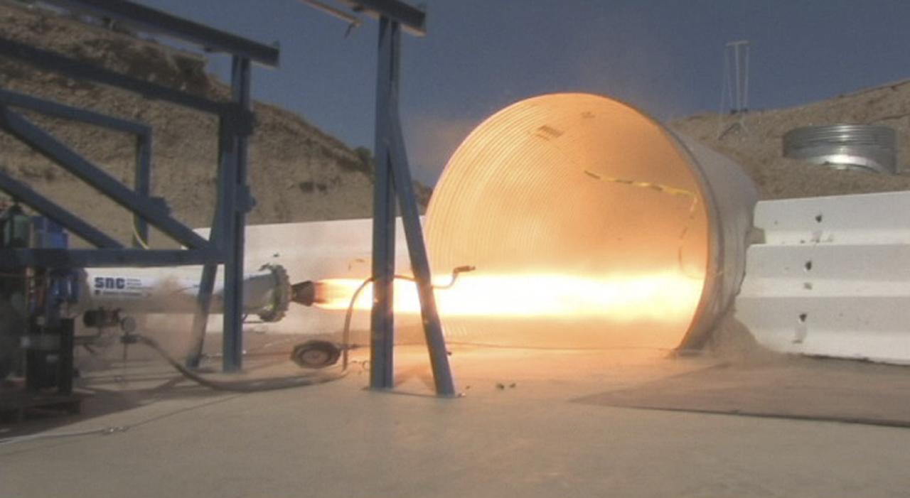
POWAY, Calif. – During NASA's Commercial Crew Development Round 1 CCDev1 activities, the rocket motor under development by Sierra Nevada Corp. for its Dream Chaser spacecraft successfully fires at the company's rocket test facility located near San Diego. NASA team members reviewed the motor's system and then watched it fire three times in one day, including one firing under vacuum ignition conditions. The tests, which simulated a complete nominal mission profile, demonstrated the multiple restart capability of Sierra Nevada's hybrid rocket. Two of the company's designed and developed hybrid rocket motors will be used as the main propulsion system on the Dream Chaser after launching aboard an Atlas V rocket. Dream Chaser is one of five systems NASA invested in during CCDev1 in order to aid in the innovation and development of American-led commercial capabilities for crew transportation and rescue services to and from the International Space Station and other low Earth orbit destinations. In 2011, NASA's Commercial Crew Program CCP entered into another funded Space Act Agreement with Sierra Nevada for the second round of commercial crew development CCDev2) so the company could further develop its Dream Chaser spacecraft for NASA transportation services. For information about CCP, visit www.nasa.gov/commercialcrew. Photo credit: Sierra Nevada Corp.
The single fire that ignited and split into nine separate fires still blazes in Southern California today. Firefighters are hoping for a break today (Thursday, May 15, 2014) but it doesn't look like luck may be on their side. Conditions continue to be bone dry with unseasonal heat (98-106 degrees) and the Santa Ana winds are kicking up and allowing these fires to easy jump fire lines. This particular fire started on Wednesday as a single fire and within a day is now nine separate fires which have burned close to 10,000 acres. These fires are threatening more than just landscape in San Diego county, they are also threatening homes, universities, a military base and a nuclear power plant. Day Two of the fires have seen them already destroying dozens of homes and forcing tens of thousands to evacuate. Camp Pendleton has also been partially evacuated due to the blazes as has the popular amusement park, Legoland. The Governor of California has declared a state of emergency. Thousands of firefighters are battling the flames both on the ground and in the air. Seven tankers and 20 military aircraft are also assisting the firefighters with their mission. Temperatures soaring over 100 degrees coupled with 30 mph wind gusts have severely hampered the efforts, however, and fire tornadoes have broken out. Fire tornadoes are caused by crosswinds that create a vortex and produce winds that twist and swirl just like a tornado but with flames that coil upwards in the center of the twister creating a terrifying specter. Although there is no chance of rain in the area for the next several days, the temperatures will start to subside on Friday and into the weekend. Winds are also expected to start to subside, giving firefighters that break that they so desperately need. This natural-color satellite image was collected by the Moderate Resolution Imaging Spectroradiometer (MODIS) aboard the Aqua satellite on May 14, 2014. Actively burning areas, detected by MODIS’s thermal bands, are outlined in red. Credit: NASA/GSFC/Jeff Schmaltz/MODIS Land Rapid Response Team <b><a href="http://www.nasa.gov/audience/formedia/features/MP_Photo_Guidelines.html" rel="nofollow">NASA image use policy.</a></b> <b><a href="http://www.nasa.gov/centers/goddard/home/index.html" rel="nofollow">NASA Goddard Space Flight Center</a></b> enables NASA’s mission through four scientific endeavors: Earth Science, Heliophysics, Solar System Exploration, and Astrophysics. Goddard plays a leading role in NASA’s accomplishments by contributing compelling scientific knowledge to advance the Agency’s mission. <b>Follow us on <a href="http://twitter.com/NASAGoddardPix" rel="nofollow">Twitter</a></b> <b>Like us on <a href="http://www.facebook.com/pages/Greenbelt-MD/NASA-Goddard/395013845897?ref=tsd" rel="nofollow">Facebook</a></b> <b>Find us on <a href="http://instagram.com/nasagoddard?vm=grid" rel="nofollow">Instagram</a></b>
This satellite image shows smoke from several fires in Oregon and California on Aug. 2, 2015. The Moderate Resolution Imaging Spectroradiometer (MODIS) instrument that flies aboard NASA's Aqua satellite captured an image of smoke from these fires Aug. 2 at 21:05 UTC (5:05 p.m. EDT). The multiple red pixels are heat signatures detected by MODIS. The smoke appears to be a light brown color. InciWeb is an interagency all-risk incident information management system that coordinates with federal, state and local agencies to manage wildfires. In Oregon smoke from the Cable Crossing Fire, the Stouts Fire and the Potter Mountain Complex Fire commingle. The Cable Crossing Fire was reported burning on forestlands protected by the Douglas Forest Protective Association (DFPA) at approximately 3:25 p.m. on Tuesday, July 28, 2015, near Oregon Highway 138 East, near Mile Post 23, east of Glide. South of the Cable Crossing Fire is the Stouts Fire also in forestlands of the DFPA. This fire was reported on Thursday, July 30, 2015, burning approximately 11 miles east of Canyonville near the community of Milo. East of the other fires is the Potter Mountain Complex Fire. These fires are located in the Deschutes Forest consists of eight fires. According to Inciweb they were started by dry lightning on Saturday, Aug. 2, at approximately 5:30 p.m. about five miles north of Toketee Lake. In northern California, smoke from the River Complex Fire, the Fork Complex Fire and the Shf July Lightning Fire was visible in the MODIS image. The River Complex currently consists of seven reported and observed fires on the Six Rivers and Shasta Trinity National Forests. Originally identified as 18 fires, some have burned together. Inciweb noted that in the Six Rivers National Forest there are fires in the Trinity Alps Wilderness. Those fires include the Groves Fire and the Elk Fire. In the Shasta-Trinity National Forest the fires include the Happy Fire at 2,256 acres, Daily Fire at 16 acres, the Look Fire at 7 acres, Onion Fire at 136 acres and Smokey Fire at 1 acre. In the same forest, south of the River Complex is the Fork Complex fire. Inciweb reported that the Fork Complex consists of (at current count) over 40 fires, all of which were ignited by lightning between July 29 and 31, 2015. To the southwest of this complex is the Mad River Complex. This is a series of seven lightning fires that started on July 30, 2015 after a lightning storm moved through Northern California. To the east of this and the other fires, burns another near Redding, California, called the Shf July Lightning Fire. This is also under the Shasta-Trinity National Forest management. At 8 p.m. PDT on Aug. 2, Inciweb reported that approximately 15 lightning strikes occurred within 24 hours throughout the Shasta Trinity National Forest and resulted in two new fires. The Caves fire, east of Mt. Shasta, is approximately one-tenth of an acre. The Bluejay fire, east of Shasta Lake, is approximately four acres. Image credit: NASA Goddard's MODIS Rapid Response Team, Jeff Schmaltz <b><a href="http://www.nasa.gov/audience/formedia/features/MP_Photo_Guidelines.html" rel="nofollow">NASA image use policy.</a></b> <b><a href="http://www.nasa.gov/centers/goddard/home/index.html" rel="nofollow">NASA Goddard Space Flight Center</a></b> enables NASA’s mission through four scientific endeavors: Earth Science, Heliophysics, Solar System Exploration, and Astrophysics. Goddard plays a leading role in NASA’s accomplishments by contributing compelling scientific knowledge to advance the Agency’s mission. <b>Follow us on <a href="http://twitter.com/NASAGoddardPix" rel="nofollow">Twitter</a></b> <b>Like us on <a href="http://www.facebook.com/pages/Greenbelt-MD/NASA-Goddard/395013845897?ref=tsd" rel="nofollow">Facebook</a></b> <b>Find us on <a href="http://instagrid.me/nasagoddard/?vm=grid" rel="nofollow">Instagram</a></b>
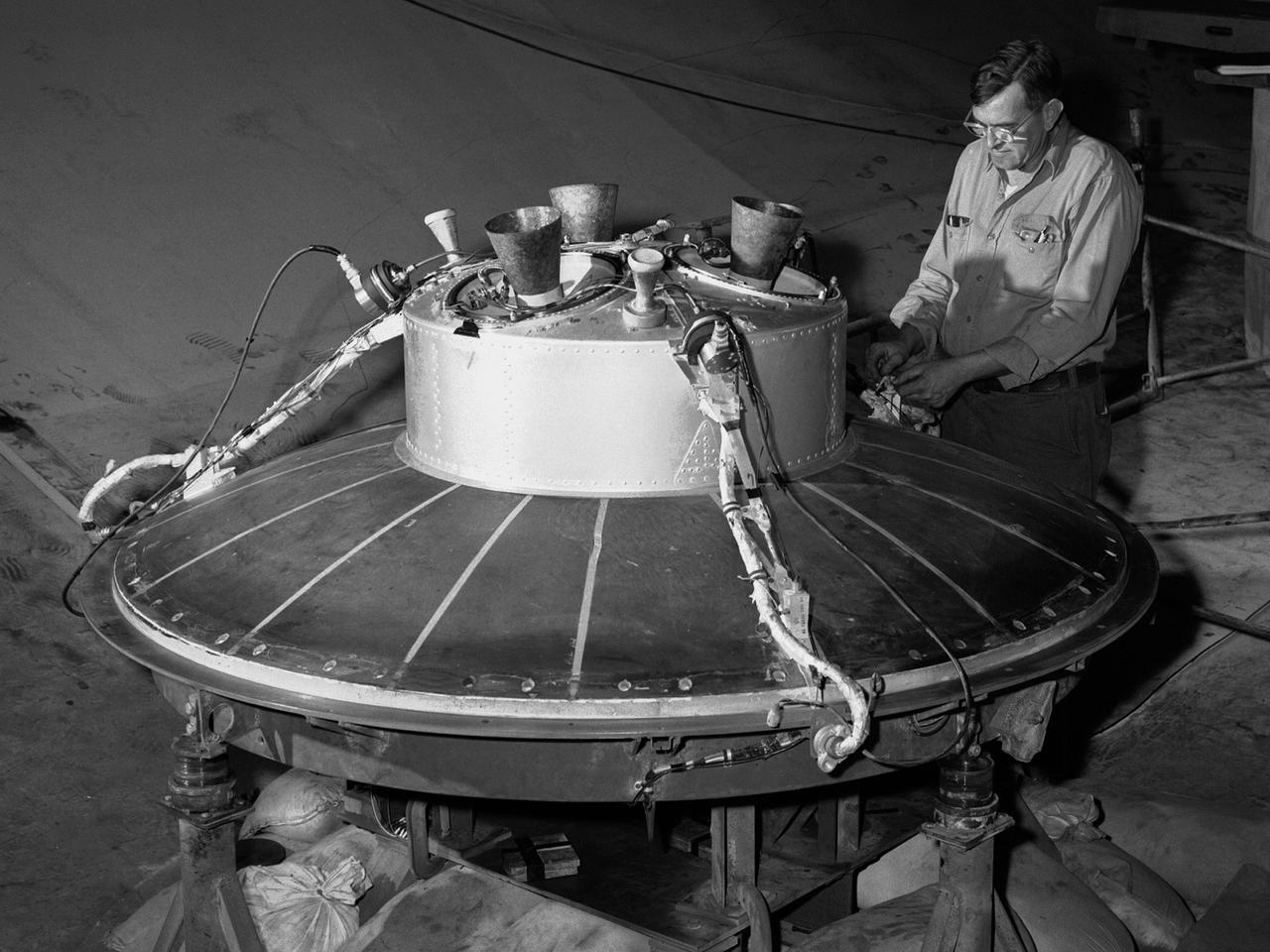
A mechanic at the National Aeronautics and Space Administration (NASA) Lewis Research Center prepares the inverted base of a Mercury capsule for a test of its posigrade retrorockets inside the Altitude Wind Tunnel. In October 1959 NASA’s Space Task Group allocated several Project Mercury assignments to Lewis. The Altitude Wind Tunnel was modified to test the Atlas separation system, study the escape tower rocket plume, train astronauts to bring a spinning capsule under control, and calibrate the capsule’s retrorockets. The turning vanes, makeup air pipes, and cooling coils were removed from the wide western end of the tunnel to create a 51-foot diameter test chamber. The Mercury capsule had a six-rocket retro-package affixed to the bottom of the capsule. Three of these were posigrade rockets used to separate the capsule from the booster and three were retrograde rockets used to slow the capsule for reentry into the earth’s atmosphere. Performance of the retrorockets was vital since there was no backup system. Qualification tests of the retrorockets began in April 1960 on a retrograde thrust stand inside the southwest corner of the Altitude Wind Tunnel. These studies showed that a previous issue concerning the delayed ignition of the propellant had been resolved. Follow-up test runs verified reliability of the igniter’s attachment to the propellant. In addition, the capsule’s retrorockets were calibrated so they would not alter the capsule’s attitude when fired.
The Los Angeles area is currently suffering the effects of three major wildfires that are blanketing the area with smoke. Over the past few days, Southern California has experienced record-breaking temperatures, topping 110 degrees Fahrenheit in some cities. The heat, in combination with offshore winds, helped to stoke the Sherpa Fire west of Santa Barbara, which has been burning since June 15, 2016. Over the weekend of June 18-19, this fire rapidly expanded in size, forcing freeway closures and evacuations of campgrounds and state beaches. On Monday, June 20, two new fires ignited in the San Gabriel Mountains north of Azusa and Duarte, together dubbed the San Gabriel Complex Fire. They have burned more than 4,900 acres since June 20, sending up plumes of smoke visible to many in the Los Angeles basin and triggering air quality warnings. More than 1,400 personnel have been battling the blazes in the scorching heat, and evacuations were ordered for neighborhoods in the foothills. On June 21, the Multi-angle Imaging SpectroRadiometer (MISR) instrument aboard NASA's Terra satellite captured this view of the San Gabriel Mountains and Los Angeles Basin from its 46-degree forward-viewing camera, which enhances the visibility of the smoke compared to the more conventional nadir (vertical) view. The width of this image is about 75 miles (120 kilometers) across. Smoke from the San Gabriel Complex Fire is visible at the very right of the image. Stereoscopic analysis of MISR's multiple camera angles is used to compute the height of the smoke plume from the San Gabriel Complex Fire. In the right-hand image, these heights are superimposed on the underlying image. The color scale shows that the plume is not much higher than the surrounding mountains. As a result, much of the smoke is confined to the local area. http://photojournal.jpl.nasa.gov/catalog/PIA20718
A forward segment is being lowered into the Transient Pressure Test Article (TPTA) test stand at thw Marshall Space Flight Center (MSFC) east test area. The TPTA test stand, 14-feet wide, 27-feet long, and 33-feet high, was built in 1987 to provide data to verify the sealing capability of the redesign solid rocket motor (SRM) field and nozzle joints. The test facility applies pressure, temperature, and external loads to a short stack of solid rocket motor hardware. The simulated SRM ignition pressure and temperature transients are achieved by firing a small amount of specially configured solid propellant. The pressure transient is synchronized with external programmable dynamic loads that simulate lift off loads at the external tank attach points. Approximately one million pounds of dead weight on top of the test article simulates the weight of the other Shuttle elements.
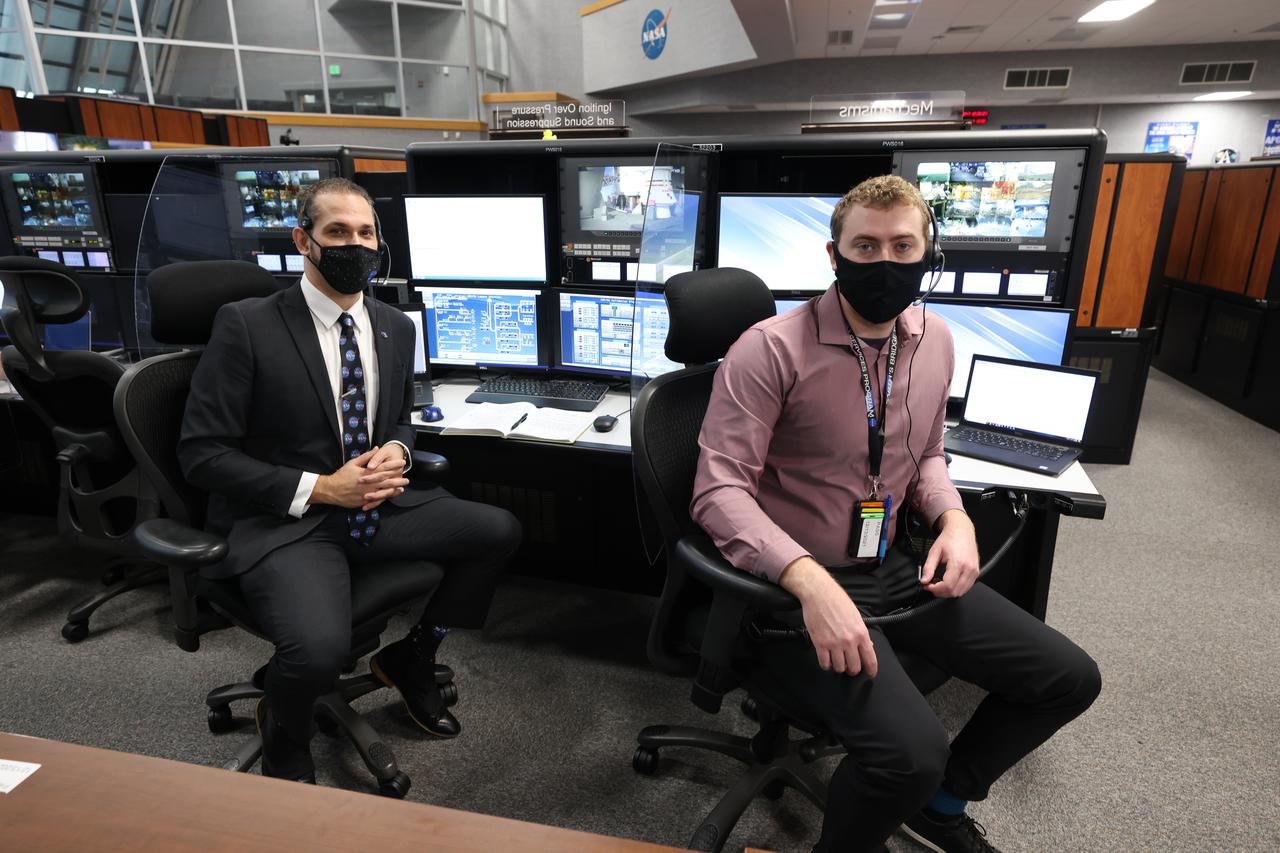
Launch team members are seated at the Mechanisms and Ignition Over Pressure and Sound Suppression System consoles inside Firing Room 1 of the Launch Control Center at NASA’s Kennedy Space Center in Florida on Dec. 13, 2021. They are participating in a joint integrated simulation for the Artemis I launch that covered both cryogenic loading and terminal countdown portions of prelaunch activities. Members of NASA’s mission management team and launch team conducted the simulation together. The Kennedy team was certified for the Artemis I launch. During Artemis I, the agency’s Orion spacecraft will lift off from Kennedy aboard NASA’s most powerful rocket – the Space Launch System – to fly farther than any spacecraft built for humans has ever flown. Through NASA’s Artemis missions, the agency, along with commercial and international partners, will establish a sustainable human presence on the Moon to prepare for missions to Mars.
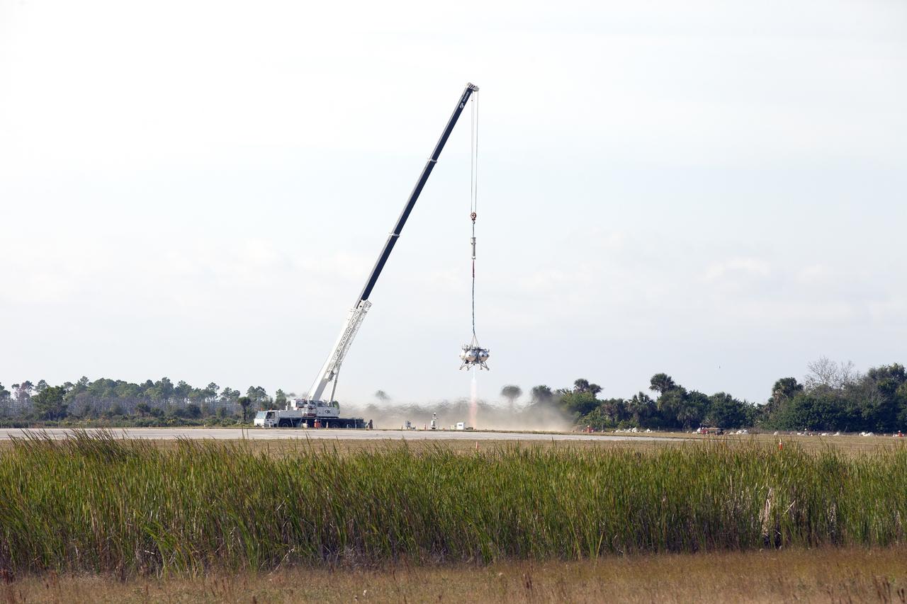
CAPE CANAVERAL, Fla. –NASA's Project Morpheus prototype lander's engine fires briefly in a tethered-flight test at the north end of the Shuttle Landing Facility at NASA’s Kennedy Space Center in Florida. However, the test was stopped following detection of an anomaly immediately after engine ignition. The tether test was cut short due to Morpheus exceeding onboard abort rate limits. The vehicle was taken back to the hangar and data from the test is being studied. After review, managers will determine when a new test date will be set. The landing facility provides the lander with the kind of field necessary for realistic testing, complete with rocks, craters and hazards to avoid. Morpheus’ ALHAT payload allows it to navigate to clear landing sites amidst rocks, craters and other hazards during its descent. For more information on Project Morpheus, visit http://morpheuslander.jsc.nasa.gov/. Photo credit: NASA/Kim Shiflett
The Marshall Space Flight Center (MSFC) successfully test fired the third in a series of Transient Pressure Test Articles (TPTA) in its east test area. The test article was a short-stack solid rocket motor 52-feet long and 12-feet in diameter. The TPTA tests were designed to evaluate the effects of temperature, pressure and external loads encountered by the SRM, primarily during ignition transients. Instrumentation on the motor recorded approximately 1,000 charnels of data to verify the structural performance, thermal response, sealing capability of the redesign field, and case-to-nozzle joints. The TPTA test stand, 14-feet wide by 26-feet long by 33-feet high, was built in 1987. The TPTA series was a joint effort among Morton Thiokol, Inc., United Space Boosters, Inc., Wyle Laboratories, and MSFC. Wyle Laboratories conducted the tests for the MSFC, which manages the redesigned SRM program for NASA.
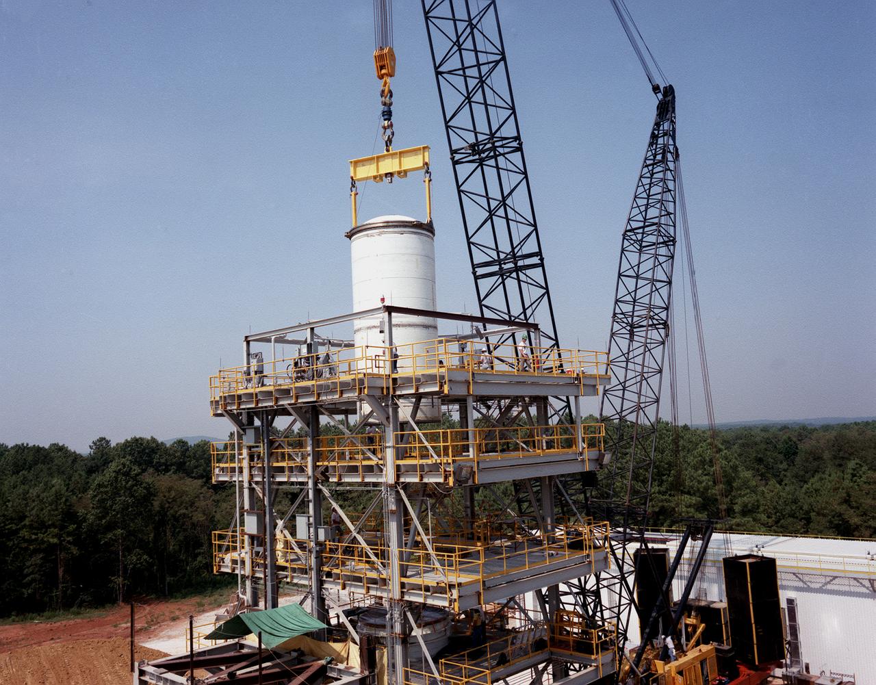
A forward segment is being lowered into the Transient Pressure Test Article (TPTA) test stand at the Marshall Space Flight Center (MSFC) east test area. The TPTA test stand, 14-feet wide, 27-feet long, and 33-feet high, was built in 1987 to provide data to verify the sealing capability of the redesign solid rocket motor (SRM) field and nozzle joints. The test facility applies pressure, temperature, and external loads to a short stack of solid rocket motor hardware. The simulated SRM ignition pressure and temperature transients are achieved by firing a small amount of specially configured solid propellant. The pressure transient is synchronized with external programmable dynamic loads that simulate lift off loads at the external tank attach points. Approximately one million pounds of dead weight on top of the test article simulates the weight of the other Shuttle elements.
CAPE CANAVERAL, Fla. -- On twin columns of fire, space shuttle Discovery's solid rocket boosters ignite for liftoff on Launch Pad 39A at NASA's Kennedy Space Center in Florida. Discovery's final launch, the STS-133 mission, to the International Space was at 4:53 p.m. EST. Discovery and its six-member crew will deliver the Permanent Multipurpose Module, packed with supplies and critical spare parts, as well as Robonaut 2, the dexterous humanoid astronaut helper, to the orbiting outpost. Discovery is flying on its 39th mission and is scheduled to be retired following STS-133. This is the 133rd Space Shuttle Program mission and the 35th shuttle voyage to the space station. For more information on the STS-133 mission, visit www.nasa.gov/mission_pages/shuttle/shuttlemissions/sts133/. Photo credit: NASA/Rusty Backer and Michael Gayle
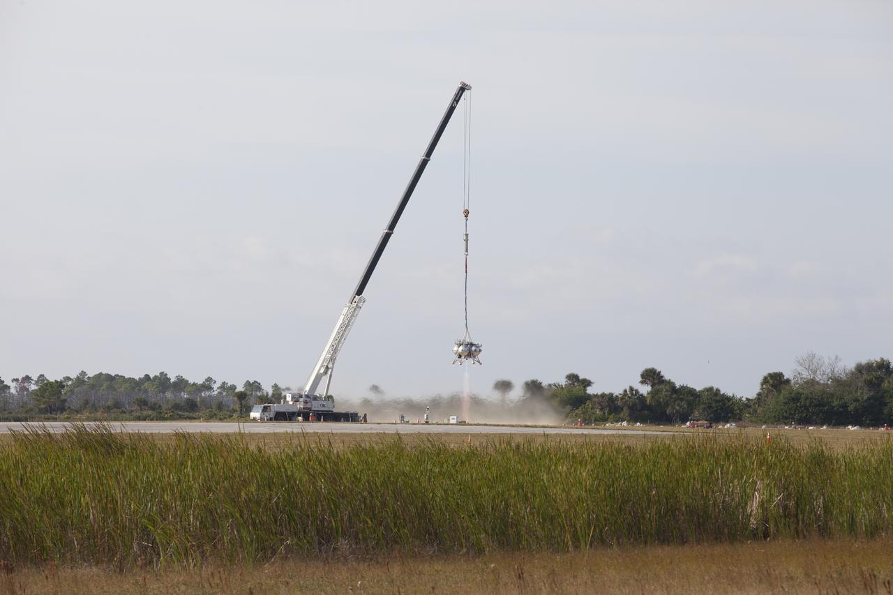
NASA's Project Morpheus prototype lander's engine fires briefly in a tethered-flight test at the north end of the Shuttle Landing Facility at NASA’s Kennedy Space Center in Florida. However, the test was stopped following detection of an anomaly immediately after engine ignition. The tether test was cut short due to Morpheus exceeding onboard abort rate limits. The vehicle was taken back to the hangar and data from the test is being studied. After review, managers will determine when a new test date will be set. The landing facility provides the lander with the kind of field necessary for realistic testing, complete with rocks, craters and hazards to avoid. Morpheus’ ALHAT payload allows it to navigate to clear landing sites amidst rocks, craters and other hazards during its descent.

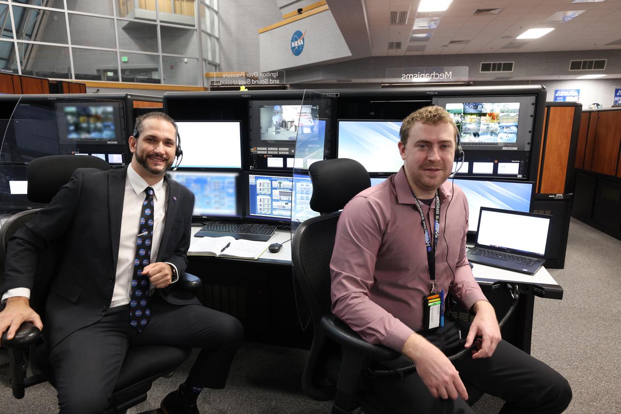
Bill Chardavoyne, left, and David Valletta, ignition overpressure/sound suppression engineers at NASA’s Kennedy Space Center in Florida, participate in an Artemis I launch countdown training simulation on Feb. 3, 2020. Under the leadership of Launch Director Charlie Blackwell-Thompson, a team of nearly 100 engineers from Orion, Space Launch System (SLS) and NASA’s Exploration Ground Systems came together in the Launch Control Center’s Firing Room 1 to work through a series of simulated challenges, as well as a final countdown procedure. During these exercises, different issues were introduced to familiarize the team with launch day operations, while providing them with an opportunity to practice how they would handle those issues in real-time. Artemis I will be the first integrated test flight of the Orion spacecraft and SLS rocket – the system that will ultimately land the first woman and the next man on the Moon.
KENNEDY SPACE CENTER, FLA. -- Sparks appear just prior to Space Shuttle Discovery's main engines firing approximately T-7 seconds before liftoff. Once the engines are running normally, the solid rocket boosters are ignited and the shuttle lifts off. Discovery lifted off on mission STS-116 at 8:47 p.m. EST. This was the second launch attempt for mission STS-116. The first launch attempt on Dec. 7 was postponed due a low cloud ceiling over Kennedy Space Center. This is Discovery's 33rd mission and the first night launch since 2002. The 20th shuttle mission to the International Space Station, STS-116 carries another truss segment, P5. It will serve as a spacer, mated to the P4 truss that was attached in September. After installing the P5, the crew will reconfigure and redistribute the power generated by two pairs of U.S. solar arrays. Landing is expected Dec. 21 at KSC. Photo courtesy of Nikon/Scott Andrews
Launch team members are seated at the Mechanisms and Ignition Over Pressure and Sound Suppression System consoles inside Firing Room 1 of the Launch Control Center at NASA’s Kennedy Space Center in Florida on Dec. 13, 2021. They are participating in a joint integrated simulation for the Artemis I launch that covered both cryogenic loading and terminal countdown portions of prelaunch activities. Members of NASA’s mission management team and launch team conducted the simulation together. The Kennedy team was certified for the Artemis I launch. During Artemis I, the agency’s Orion spacecraft will lift off from Kennedy aboard NASA’s most powerful rocket – the Space Launch System – to fly farther than any spacecraft built for humans has ever flown. Through NASA’s Artemis missions, the agency, along with commercial and international partners, will establish a sustainable human presence on the Moon to prepare for missions to Mars.
KENNEDY SPACE CENTER, FLA. -- Nearly enveloped by the smoke after ignition, the Delta II rocket carrying NASA's Dawn spacecraft rises from the smoke and fire on the launch pad to begin its 1.7-billion-mile journey through the inner solar system to study a pair of asteroids. Liftoff was at 7:34 a.m. EDT from Pad 17-B at Cape Canaveral Air Force Station. Dawn is the ninth mission in NASA's Discovery Program. The spacecraft will be the first to orbit two planetary bodies, asteroid Vesta and dwarf planet Ceres, during a single mission. Vesta and Ceres lie in the asteroid belt between Mars and Jupiter. It is also NASA's first purely scientific mission powered by three solar electric ion propulsion engines. Photo credit: NASA/Sandra Joseph & Rafael Hernandez
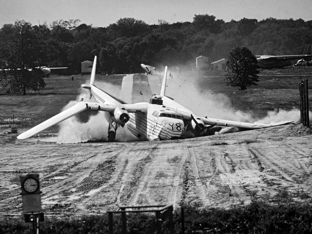
A Fairchild C-82 Packet is purposely destroyed by researchers at the National Advisory Committee for Aeronautics (NACA) Lewis Flight Propulsion Laboratory. In response to an escalating number of transport aircraft crashes in the mid-1940s, the NACA researchers undertook a decade-long investigation into a number of issues surrounding low-altitude aircraft crashes. The tests were conducted at the Ravenna Arsenal, approximately 60 miles south of the Lewis laboratory in Cleveland, Ohio. The aircraft were excess military transports from World War II. The aircraft was guided down the runway at speeds of 80 to 105 miles per hour. It came into contact with poles which tore open the 1500-gallon fuel tanks in the wings before reaching the barriers at the end of the runway. Fuel poured from the tanks and supply lines, resulting in the spread of both liquid fuel and a large cloud of spray. Solomon Weiss developed a method of dying the fuel red to improve its visibility during the crashes. This red fuel cloud trailed slightly behind the skidding aircraft, then rushed forward when the aircraft stopped. The nine-crash initial phase of testing used Lockheed C-56 Lodestar and C-82 transport aircraft to identify potential ignition sources and analyze the spread of flammable materials. The researchers were able to identify different classes of ignition sources, fuel disbursement patterns, the time when a particular ignition source might appear, rate of the fire spread, cabin survival times, and deceleration rates.
VAN HORN, Texas – Blue Origin’s test stand, back right, is framed by a wind mill at the company’s West Texas facility. The company used this test stand to fire its powerful new hydrogen- and oxygen-fueled American rocket engine, the BE-3. The engine fired at full power for more than two minutes to simulate a launch, then paused for about four minutes, mimicking a coast through space before it re-ignited for a brief final burn. The last phase of the test covered the work the engine could perform in landing the booster back softly on Earth. Blue Origin, a partner of NASA’s Commercial Crew Program, or CCP, is developing its Orbital Launch Vehicle, which could eventually be used to launch the company's Space Vehicle into orbit to transport crew and cargo to low-Earth orbit. CCP is aiding in the innovation and development of American-led commercial capabilities for crew transportation and rescue services to and from the station and other low-Earth orbit destinations by the end of 2017. For information about CCP, visit www.nasa.gov/commercialcrew. Photo credit: NASA/Lauren Harnett
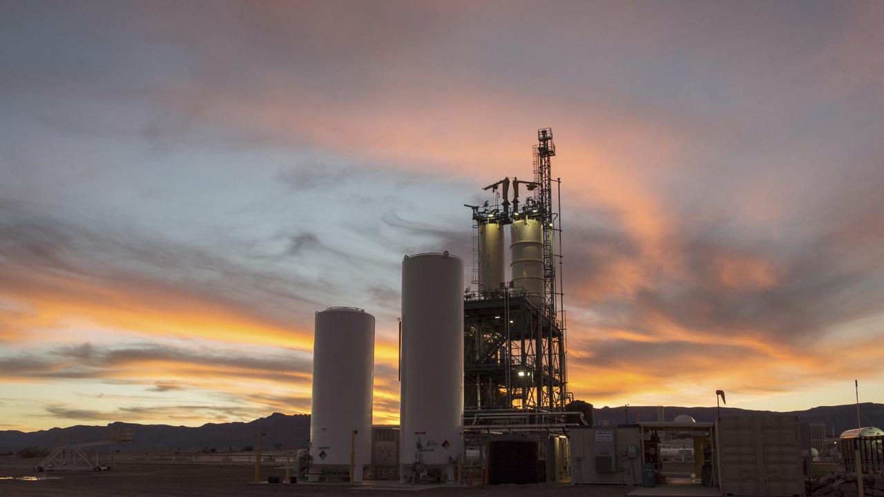
VAN HORN, Texas – The sun sets over a test stand at Blue Origin’s West Texas facility. The company used this test stand to fire its powerful new hydrogen- and oxygen-fueled American rocket engine, the BE-3, on Nov. 20. The BE-3 fired at full power for more than two minutes to simulate a launch, then paused for about four minutes, mimicking a coast through space before it re-ignited for a brief final burn. The last phase of the test covered the work the engine could perform in landing the booster back softly on Earth. Blue Origin, a partner of NASA’s Commercial Crew Program, or CCP, is developing its Orbital Launch Vehicle, which could eventually be used to launch the company's Space Vehicle into orbit to transport crew and cargo to low-Earth orbit. CCP is aiding in the innovation and development of American-led commercial capabilities for crew transportation and rescue services to and from the station and other low-Earth orbit destinations by the end of 2017. For information about CCP, visit www.nasa.gov/commercialcrew. Photo credit: NASA/Lauren Harnett
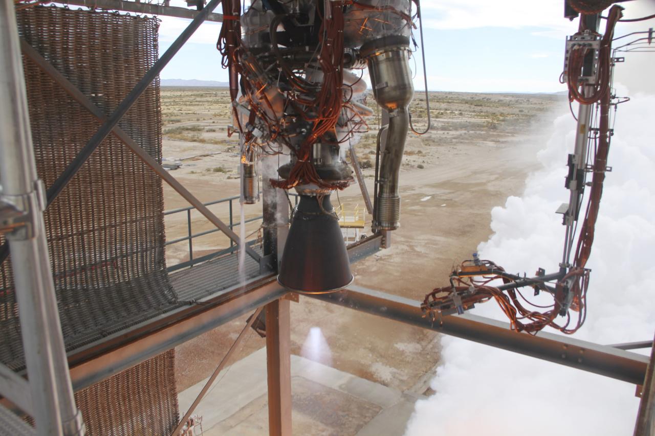
VAN HORN, Texas – Blue Origin test fires a powerful new hydrogen- and oxygen-fueled American rocket engine at the company's West Texas facility. During the test, the BE-3 engine fired at full power for more than two minutes to simulate a launch, then paused for about four minutes, mimicking a coast through space before it re-ignited for a brief final burn. The last phase of the test covered the work the engine could perform in landing the booster back softly on Earth. Blue Origin, a partner of NASA’s Commercial Crew Program, or CCP, is developing its Orbital Launch Vehicle, which could eventually be used to launch the company's Space Vehicle into orbit to transport crew and cargo to low-Earth orbit. CCP is aiding in the innovation and development of American-led commercial capabilities for crew transportation and rescue services to and from the station and other low-Earth orbit destinations by the end of 2017. For information about CCP, visit www.nasa.gov/commercialcrew. Photo credit: Blue Origin
STS070-386-027 (13-22 JULY 1995) --- High-speed film provided this close-up view of the Space Shuttle Discovery’s aft, featuring the ignition of one of the primary thrusters. Note the impact of the firing on the starboard side of the vertical stabilizer. Crew members told a August 11, 1995, gathering of Johnson Space Center (JSC) employees that the Window Experiment (WINDEX) paid close attention to surface glow, jet plumes, water dumps, aurora and airglow. The data collection is part of an effort to avoid misinterpretation of measurements of Earth, the solar system and starts taken from satellites in low Earth-orbits and prevent damage to sensitive systems and solar arrays during rendezvous and docking. Such firings of the thrusters increase local densities of gases in the atmosphere dramatically and introduce non-natural elements that react with the atmosphere dramatically and spacecraft systems enveloped by the thruster plume. WINDEX recorded phenomena associated with thruster start-up and shut-down transients and observed the effect of the transients on Shuttle glow phenomenon.
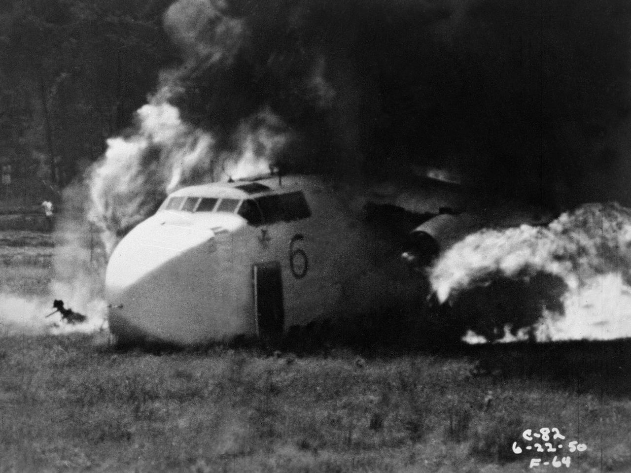
Researchers at the National Advisory Committee for Aeronautics (NACA) Lewis Flight Propulsion Laboratory purposely crash a Fairchild C-82 Packet aircraft to study flame propagation. A rash of passenger aircraft crashes in 1946 and 1947 spurred a White House call for an investigatory board staffed by members of the Civil Aeronautics Board, military, and the NACA. The group addressed fire segregation, extinguishment, and prevention. The NACA established a Subcommittee on Aircraft Fire Prevention in February 1948 to coordinate its efforts. The Lewis team simulated situations in which an aircraft failed to become airborne during takeoff resulting in crashes into embankments and other objects. The Lewis researchers initially used surplus C-46 and C-82 military transport planes. In these situations, the aircraft generally suffered damage to its fuel system and other components, but was structurally survivable. The aircraft were mounted to a rail that ran down a 1700-foot long test runway. The aircraft was secured at the starting point with an anchor pier so it could get its engines up to takeoff speed before launching down the track. Barriers at the end of the runway were designed to simulate a variety of different types of crashes. Telemetry and high-speed cameras were crucial elements in these studies. The preliminary testing phase identified potential ignition sources and analyzed the spread of flammable materials.
VAN HORN, Texas – Blue Origin test fires a powerful new hydrogen- and oxygen-fueled American rocket engine at the company's West Texas facility. During the test, the BE-3 engine fired at full power for more than two minutes to simulate a launch, then paused for about four minutes, mimicking a coast through space before it re-ignited for a brief final burn. The last phase of the test covered the work the engine could perform in landing the booster back softly on Earth. Blue Origin, a partner of NASA’s Commercial Crew Program, or CCP, is developing its Orbital Launch Vehicle, which could eventually be used to launch the company's Space Vehicle into orbit to transport crew and cargo to low-Earth orbit. CCP is aiding in the innovation and development of American-led commercial capabilities for crew transportation and rescue services to and from the station and other low-Earth orbit destinations by the end of 2017. For information about CCP, visit www.nasa.gov/commercialcrew. Photo credit: NASA/Lauren Harnett
STS035-28-006 (2-10 Dec 1990) --- STS-35 Astronomy Laboratory 1 (ASTRO-1) telescopes, in on-orbit operating position in the payload bay (PLB), are silhouetted against an reaction control system (RCS) right thruster firing. Three ultraviolet telescopes are mounted and precisely co-aligned on a common structure, called the cruciform, that is attached to the instrument pointing system (IPS). Here the IPS holds the telescopes in a position that is parallel to the Earth's limb below. Visible on the cruciform are the star tracker (S TRK) (silver cone at the top), the Ultraviolet Imaging Telescope (UIT) (behind S TRK), and the Hopkins Ultraviolet Telescope(HUT).
The thrust stand in the Rocket Engine Test Facility at the National Aeronautics and Space Administration (NASA) Lewis Research Center in Cleveland, Ohio. The Rocket Engine Test Facility was constructed in the mid-1950s to expand upon the smaller test cells built a decade before at the Rocket Laboratory. The $2.5-million Rocket Engine Test Facility could test larger hydrogen-fluorine and hydrogen-oxygen rocket thrust chambers with thrust levels up to 20,000 pounds. Test Stand A, seen in this photograph, was designed to fire vertically mounted rocket engines downward. The exhaust passed through an exhaust gas scrubber and muffler before being vented into the atmosphere. Lewis researchers in the early 1970s used the Rocket Engine Test Facility to perform basic research that could be utilized by designers of the Space Shuttle Main Engines. A new electronic ignition system and timer were installed at the facility for these tests. Lewis researchers demonstrated the benefits of ceramic thermal coatings for the engine’s thrust chamber and determined the optimal composite material for the coatings. They compared the thermal-coated thrust chamber to traditional unlined high-temperature thrust chambers. There were more than 17,000 different configurations tested on this stand between 1973 and 1976. The Rocket Engine Test Facility was later designated a National Historic Landmark for its role in the development of liquid hydrogen as a propellant.
Generally the old saying “where there is smoke, there is fire” rings true, but when thick, hot smoke rises high aloft into the atmosphere it may travel hundreds, sometimes thousands of kilometers away from the source. This was the case on July 6, 2013 when the Moderate Resolution Imaging Spectroradiometer (MODIS) instrument flying on NASA’s Terra satellite captured this true-color image of a thick river of smoke curling across the Atlantic Ocean. In the west of the image, the green land of Canada can be seen, most of which is covered by a thin gray haze. A thick veil of smoke obscures much of southern Canada, and this tan-gray veil blows to the east, then to the northeast. The color of the smoke appears both tan and gray, and is stretched into brush-stroke like curves across the ocean, which disappears from view under the smoke. The smoke filled plume is so high that it even hides the bright white clouds from view as it travels over them. Fires have been burning across Canada since early June, especially in Manitoba and Quebec. Rain in Quebec on July 5 helped diminish the fires in that location, although a severe fire was ignited when a freight train carrying oil derailed in the small, picturesque town of Lac-Megantic. This accident, which occurred on July 6, the same day this image was captured, killed at least 35 people and poured thick smoke into the skies. Credit: NASA/GSFC/Jeff Schmaltz/MODIS Land Rapid Response Team <b><a href="http://www.nasa.gov/audience/formedia/features/MP_Photo_Guidelines.html" rel="nofollow">NASA image use policy.</a></b> <b><a href="http://www.nasa.gov/centers/goddard/home/index.html" rel="nofollow">NASA Goddard Space Flight Center</a></b> enables NASA’s mission through four scientific endeavors: Earth Science, Heliophysics, Solar System Exploration, and Astrophysics. Goddard plays a leading role in NASA’s accomplishments by contributing compelling scientific knowledge to advance the Agency’s mission. <b>Follow us on <a href="http://twitter.com/NASA_GoddardPix" rel="nofollow">Twitter</a></b> <b>Like us on <a href="http://www.facebook.com/pages/Greenbelt-MD/NASA-Goddard/395013845897?ref=tsd" rel="nofollow">Facebook</a></b> <b>Find us on <a href="http://instagram.com/nasagoddard?vm=grid" rel="nofollow">Instagram</a></b>
Eight major wildfires burned through forests and grasslands in the Pacific Northwest in late-July 2013, threatening homes and forcing road closings and evacuations. Many parts of Washington and Oregon faced extreme fire threats, as strong thunderstorms lined up to hit parched forests and grasslands with lightning. On July 28, 2013, the Operational Land Imager (OLI) on Landsat 8 captured these images of the Mile Marker 28 fire in the Simcoe Mountains northeast of Goldendale, Washington. Smoke blew east toward Kennewick, Pasco, and Richland. The lower image shows a closer view of smoke billowing up from the most active part of the fire. Ignited on July 24, 2013, the fire charred more than 22,000 acres (8,900 hectares) by July 30, when more than 1,000 firefighters achieved 40 percent containment. The blaze forced the evacuation of dozens of homes and the closure of US Highway 97. Through July 25, 450 wildfires had burned 10,220 acres (4,136 hectares) in Washington, while Oregon saw 603 fires that burned 63,135 acres (25,549 hectares). In all, 2.3 million acres burned across the United States by late-July, below the national average. Over the past ten years, an average of 4.2 million acres had burned in the United States by the end of each July. While coastal and western Washington receive heavy rain throughout the year, the rain shadow caused by the Cascades leaves central Washington quite dry. The mountains force moist air from the Pacific to rise, causing it to cool and condense into rain or snow on the windward side of the Cascades. So little moisture is left by the time air passes over the Cascades, that the area around Mile Marker 28 typically receives just 8 inches (20 centimeters) of precipitation per year. NASA Earth Observatory image by Jesse Allen and Robert Simmon, using Landsat data from the U.S. Geological Survey. Caption by Adam Voiland Instrument: Landsat 8 - OLI More info: <a href="http://earthobservatory.nasa.gov/IOTD/view.php?id=81738" rel="nofollow">earthobservatory.nasa.gov/IOTD/view.php?id=81738</a> Credit: <b><a href="http://www.earthobservatory.nasa.gov/" rel="nofollow"> NASA Earth Observatory</a></b> <b><a href="http://www.nasa.gov/audience/formedia/features/MP_Photo_Guidelines.html" rel="nofollow">NASA image use policy.</a></b> <b><a href="http://www.nasa.gov/centers/goddard/home/index.html" rel="nofollow">NASA Goddard Space Flight Center</a></b> enables NASA’s mission through four scientific endeavors: Earth Science, Heliophysics, Solar System Exploration, and Astrophysics. Goddard plays a leading role in NASA’s accomplishments by contributing compelling scientific knowledge to advance the Agency’s mission. <b>Follow us on <a href="http://twitter.com/NASA_GoddardPix" rel="nofollow">Twitter</a></b> <b>Like us on <a href="http://www.facebook.com/pages/Greenbelt-MD/NASA-Goddard/395013845897?ref=tsd" rel="nofollow">Facebook</a></b> <b>Find us on <a href="http://instagram.com/nasagoddard?vm=grid" rel="nofollow">Instagram</a></b>
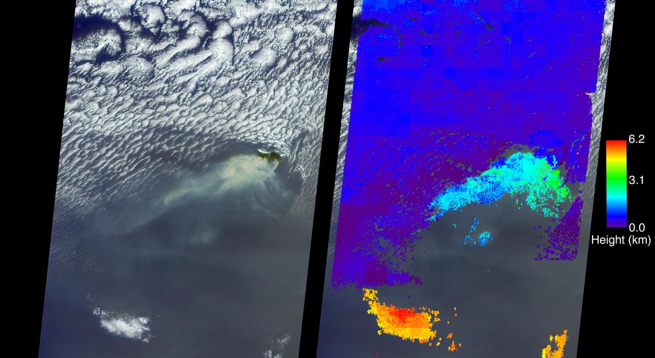
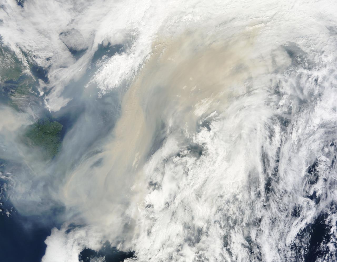
A wildfire spread to the capital city of Funchal on the island of Madeira, an autonomous region of Portugal, over the nighttime hours of Tuesday, Aug. 9, 2016, with three deaths reported and hundreds of others hospitalized. Several homes and a luxury hotel have burned, and a thousand people have been evacuated. The three fatalities are reported to be elderly people who were unable to escape when their homes caught fire. The fire ignited Monday, Aug. 8, after several weeks of scorching temperatures topping 95 degrees Fahrenheit and very dry weather. The entire island is only 30 miles (48 kilometers) from end to end, which naturally makes protecting the island's 270,000 residents and many tourists more difficult. The MISR (Multi-angle Imaging SpectroRadiometer) instrument aboard NASA's Terra satellite passed directly over the island of Madeira on Wednesday, Aug. 10, 2016. The left image is a true-color image taken by MISR's 60-degree forward-pointing camera. This oblique view gives a better view of the smoke than a downward-pointing view. The island of Madeira is the only land within the field of view, and the smoke from the wildfire is being blown to the southwest. The city of Funchal is located on the southeastern coast of the island. MISR's nine cameras, each viewing Earth at a different angle, can be used to determine the height of clouds and smoke above the surface in much the same way that our two eyes, pointing in slightly different directions, give us depth perception. The right-hand image shows MISR's publically available standard cloud top height product. These data show that the main body of clouds is indeed very low, less than 0.6 miles (1 kilometer) above sea level, while the smoke plume is about 1.9 miles (3 kilometers) high at the source, dropping lower as it is blown to the southwest. A stereo "anaglyph" of this scene is also available at PIA20886. As can be seen from both the MISR height product and the 3D anaglyph, the isolated clouds to the south are much higher than either the low clouds or the plume. Interestingly, the low clouds drop to almost sea level and then die out near where the smoke is present. These data were acquired during Terra orbit 88524. http://photojournal.jpl.nasa.gov/catalog/PIA20887
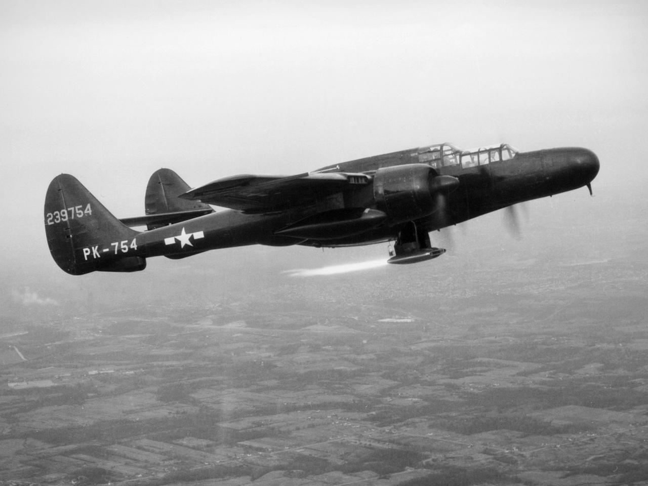
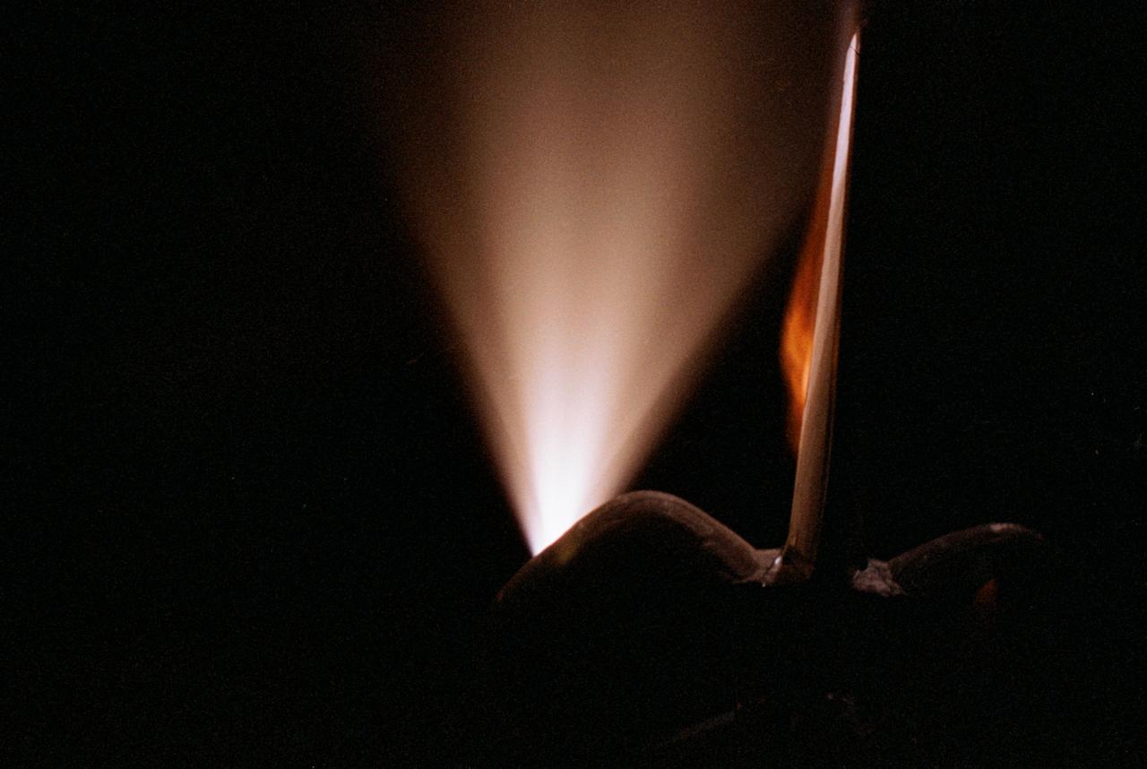
The National Advisory Committee for Aeronautics (NACA) Lewis Flight Propulsion Laboratory obtained a Northrop P-61 Black Widow in October 1945 and modified it to serve as a subsonic testbed for ramjet engines and swept-wing aircraft models. The P-61 was developed during World War II specifically for nighttime attacks. It was the largest and heaviest US fighter in the war. The P-61’s unique design included an abbreviated fuselage and twin booms that were joined by a single tail. To facilitate its nighttime missions, the P-61 was painted black and carried a radar system in its nose. It was designed so the crew could perform their flight and tracking tasks in complete darkness. NACA Lewis was in the midst of a massive research effort on ramjets when it acquired the Black Widow. Researchers used the aircraft to accelerate the ramjet until it reached a velocity at which it could be ignited. A ramjet can be seen being fired underneath the aircraft in this photograph. Sensors and instrumentation fed data from the ramjet to the pilot and researchers on the ground. The NACA researchers created a rectangular ramjet with a V-shaped gutter flameholder. The researchers installed the ramjet on the P-61 and flew it at subsonic speeds over a range of altitudes up to 29,000 feet. The ramjet had been previously tested at low speeds on a test stand on the hangar apron. The rectangular ramjet was also used to study different types of flameholders and nozzles used to spray fuel into the combustion chamber. The Black Widow was transferred from Lewis in October 1948.
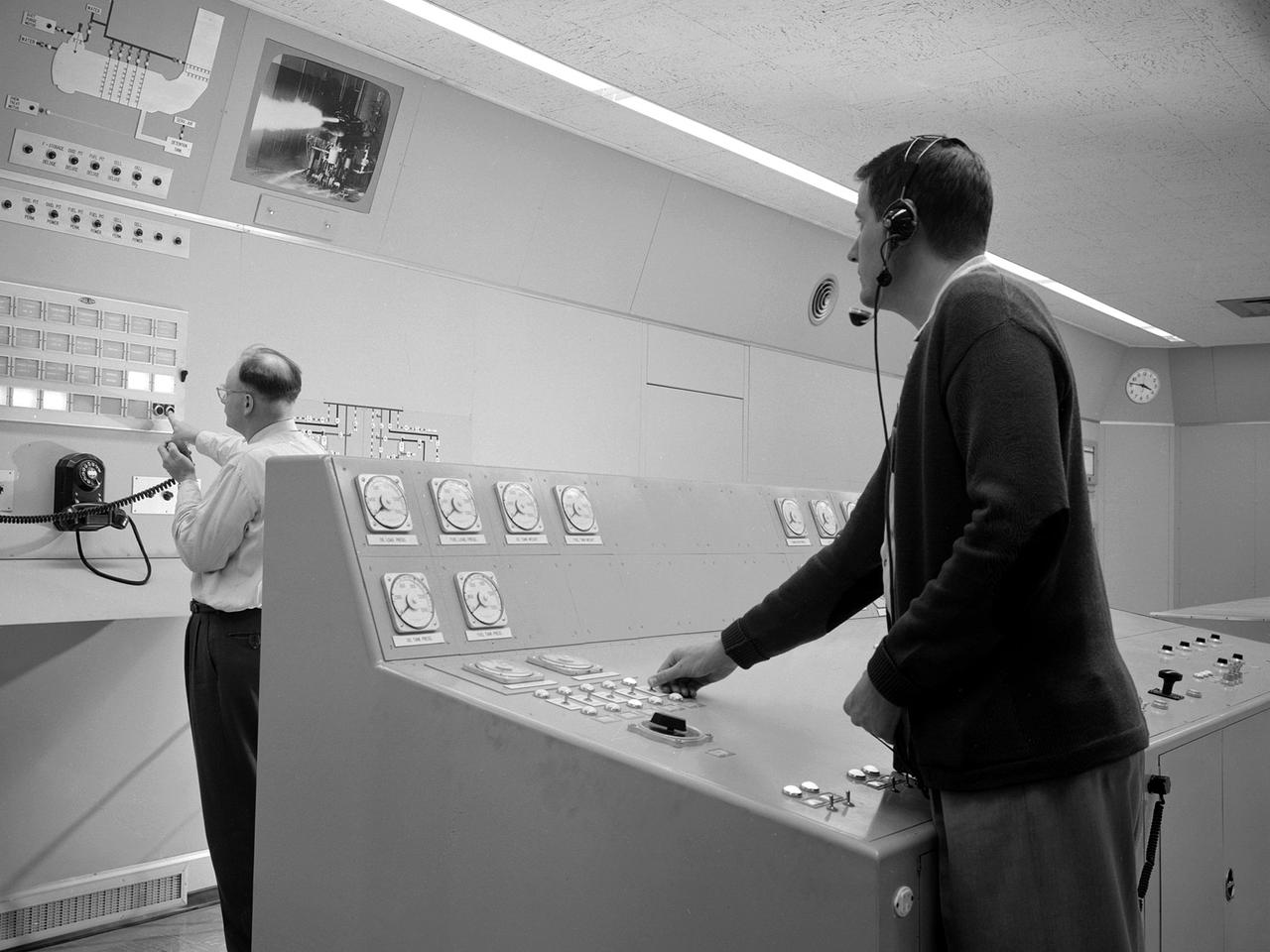
Test engineers monitor an engine firing from the control room of the Rocket Engine Test Facility at the National Advisory Committee for Aeronautics (NACA) Lewis Flight Propulsion Laboratory. The Rocket Engine Test Facility, built in the early 1950s, had a rocket stand designed to evaluate high-energy propellants and rocket engine designs. The facility was used to study numerous different types of rocket engines including the Pratt and Whitney RL-10 engine for the Centaur rocket and Rocketdyne’s F-1 and J-2 engines for the Saturn rockets. The Rocket Engine Test Facility was built in a ravine at the far end of the laboratory because of its use of the dangerous propellants such as liquid hydrogen and liquid fluorine. The control room was located in a building 1,600 feet north of the test stand to protect the engineers running the tests. The main control and instrument consoles were centrally located in the control room and surrounded by boards controlling and monitoring the major valves, pumps, motors, and actuators. A camera system at the test stand allowed the operators to view the tests, but the researchers were reliant on data recording equipment, sensors, and other devices to provide test data. The facility’s control room was upgraded several times over the years. Programmable logic controllers replaced the electro-mechanical control devices. The new controllers were programed to operate the valves and actuators controlling the fuel, oxidant, and ignition sequence according to a predetermined time schedule.
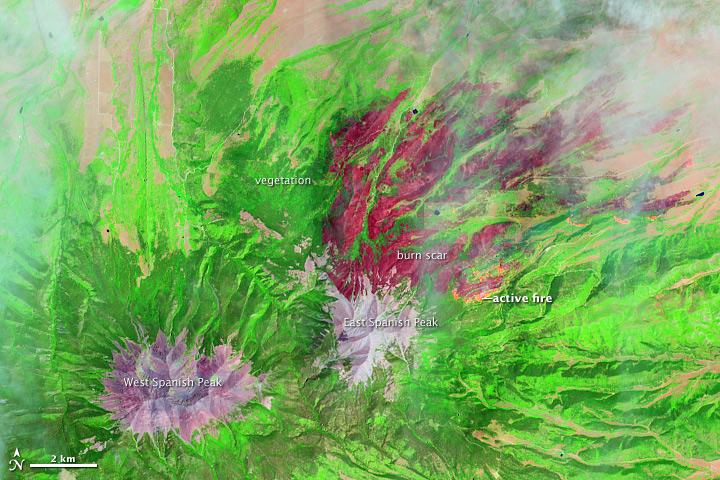
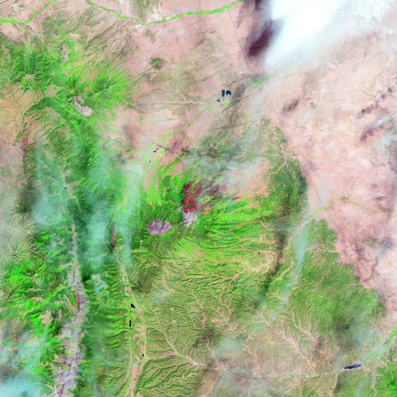
On June 22, 2013, the Operational Land Imager (OLI) on Landsat 8 captured this false-color image of the East Peak fire burning in southern Colorado near Trinidad. Burned areas appear dark red, while actively burning areas look orange. Dark green areas are forests; light green areas are grasslands. Lightning ignited the blaze on June 19, 2013. By June 25, it had burned nearly 13,500 acres (5,500 hectares). NASA Earth Observatory image by Jesse Allen and Robert Simmon, using Landsat data from the U.S. Geological Survey. Caption by Adam Voiland. Instrument: Landsat 8 - OLI More images from this event: <a href="http://1.usa.gov/14DesQC" rel="nofollow">1.usa.gov/14DesQC</a> Credit: <b><a href="http://www.earthobservatory.nasa.gov/" rel="nofollow"> NASA Earth Observatory</a></b> <b><a href="http://www.nasa.gov/audience/formedia/features/MP_Photo_Guidelines.html" rel="nofollow">NASA image use policy.</a></b> <b><a href="http://www.nasa.gov/centers/goddard/home/index.html" rel="nofollow">NASA Goddard Space Flight Center</a></b> enables NASA’s mission through four scientific endeavors: Earth Science, Heliophysics, Solar System Exploration, and Astrophysics. Goddard plays a leading role in NASA’s accomplishments by contributing compelling scientific knowledge to advance the Agency’s mission. <b>Follow us on <a href="http://twitter.com/NASA_GoddardPix" rel="nofollow">Twitter</a></b> <b>Like us on <a href="http://www.facebook.com/pages/Greenbelt-MD/NASA-Goddard/395013845897?ref=tsd" rel="nofollow">Facebook</a></b> <b>Find us on <a href="http://instagram.com/nasagoddard?vm=grid" rel="nofollow">Instagram</a></b>
On June 22, 2013, the Operational Land Imager (OLI) on Landsat 8 captured this false-color image of the East Peak fire burning in southern Colorado near Trinidad. Burned areas appear dark red, while actively burning areas look orange. Dark green areas are forests; light green areas are grasslands. Lightning ignited the blaze on June 19, 2013. By June 25, it had burned nearly 13,500 acres (5,500 hectares). NASA Earth Observatory image by Jesse Allen and Robert Simmon, using Landsat data from the U.S. Geological Survey. Caption by Adam Voiland. Instrument: Landsat 8 - OLI More images from this event: <a href="http://1.usa.gov/14DesQC" rel="nofollow">1.usa.gov/14DesQC</a> Credit: <b><a href="http://www.earthobservatory.nasa.gov/" rel="nofollow"> NASA Earth Observatory</a></b> <b><a href="http://www.nasa.gov/audience/formedia/features/MP_Photo_Guidelines.html" rel="nofollow">NASA image use policy.</a></b> <b><a href="http://www.nasa.gov/centers/goddard/home/index.html" rel="nofollow">NASA Goddard Space Flight Center</a></b> enables NASA’s mission through four scientific endeavors: Earth Science, Heliophysics, Solar System Exploration, and Astrophysics. Goddard plays a leading role in NASA’s accomplishments by contributing compelling scientific knowledge to advance the Agency’s mission. <b>Follow us on <a href="http://twitter.com/NASA_GoddardPix" rel="nofollow">Twitter</a></b> <b>Like us on <a href="http://www.facebook.com/pages/Greenbelt-MD/NASA-Goddard/395013845897?ref=tsd" rel="nofollow">Facebook</a></b> <b>Find us on <a href="http://instagram.com/nasagoddard?vm=grid" rel="nofollow">Instagram</a></b>
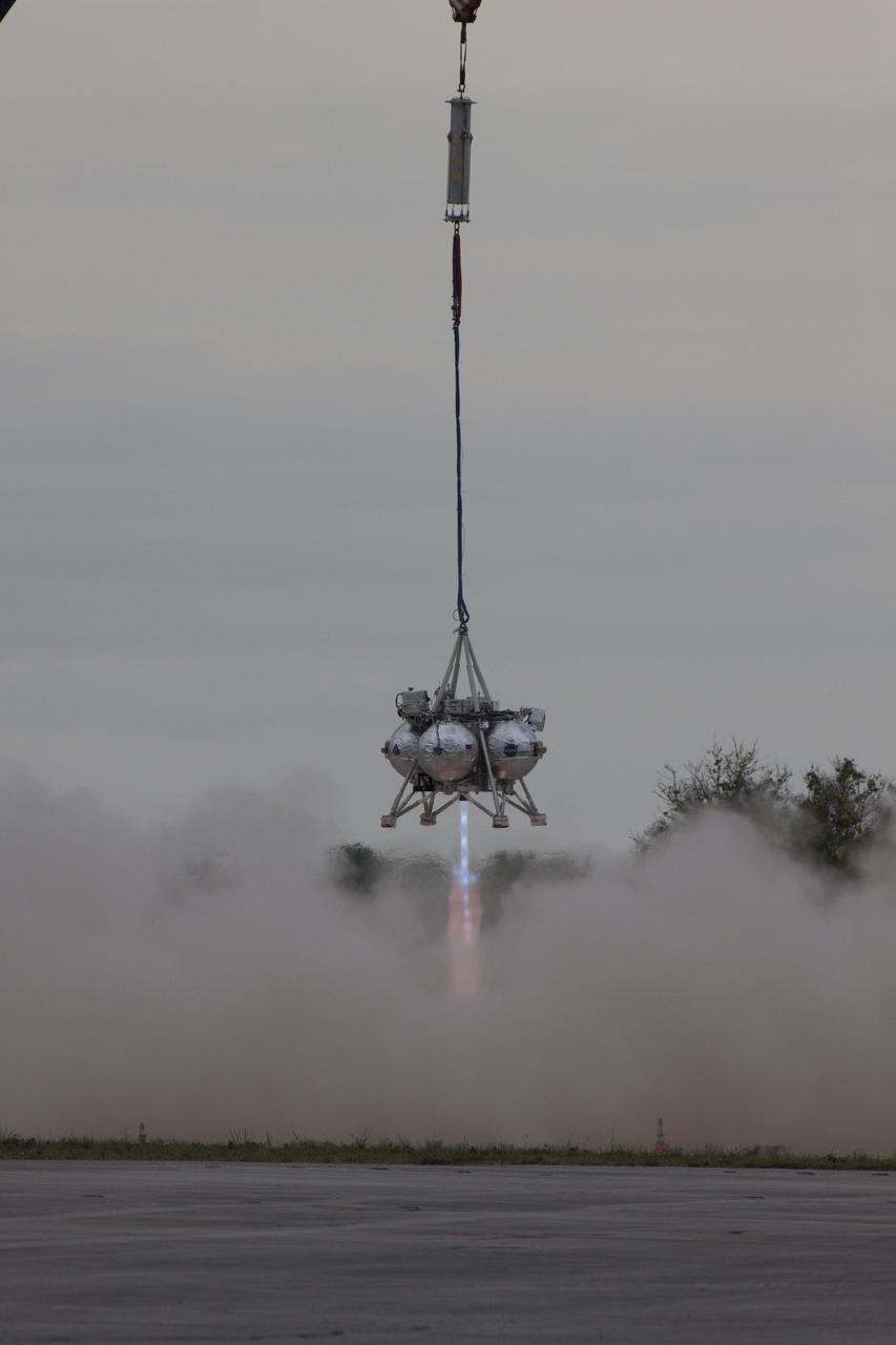
CAPE CANAVERAL, Fla. – NASA's Project Morpheus prototype lander is lifted by crane and its engine is ignited during a tethered test near a new launch site at the north end of the Shuttle Landing Facility at NASA's Kennedy Space Center in Florida. The launch pad was moved to a different location at the landing facility to support the next phase of flight testing. The test was performed to verify the lander's recently installed autonomous landing and hazard avoidance technology, or ALHAT, sensors and integration systems. During the test, Morpheus was lifted by crane to 20 feet for an engine firing of about 74 seconds and then lowered to the ground. With the successful completion of the test, the Morpheus project team will begin preparing for the first free flight test with ALHAT. Morpheus tests NASA’s ALHAT, and an engine that runs on liquid oxygen and methane, or green propellants, into a fully-operational lander that could deliver cargo to other planetary surfaces. The landing facility provides the lander with the kind of field necessary for realistic testing, complete with rocks, craters and hazards to avoid. Morpheus’ ALHAT payload allows it to navigate to clear landing sites amidst rocks, craters and other hazards during its descent. Project Morpheus is being managed under the Advanced Exploration Systems, or AES, Division in NASA’s Human Exploration and Operations Mission Directorate. The efforts in AES pioneer new approaches for rapidly developing prototype systems, demonstrating key capabilities and validating operational concepts for future human missions beyond Earth orbit. For more information on Project Morpheus, visit http://morpheuslander.jsc.nasa.gov/. Photo credit: NASA/Glenn Benson
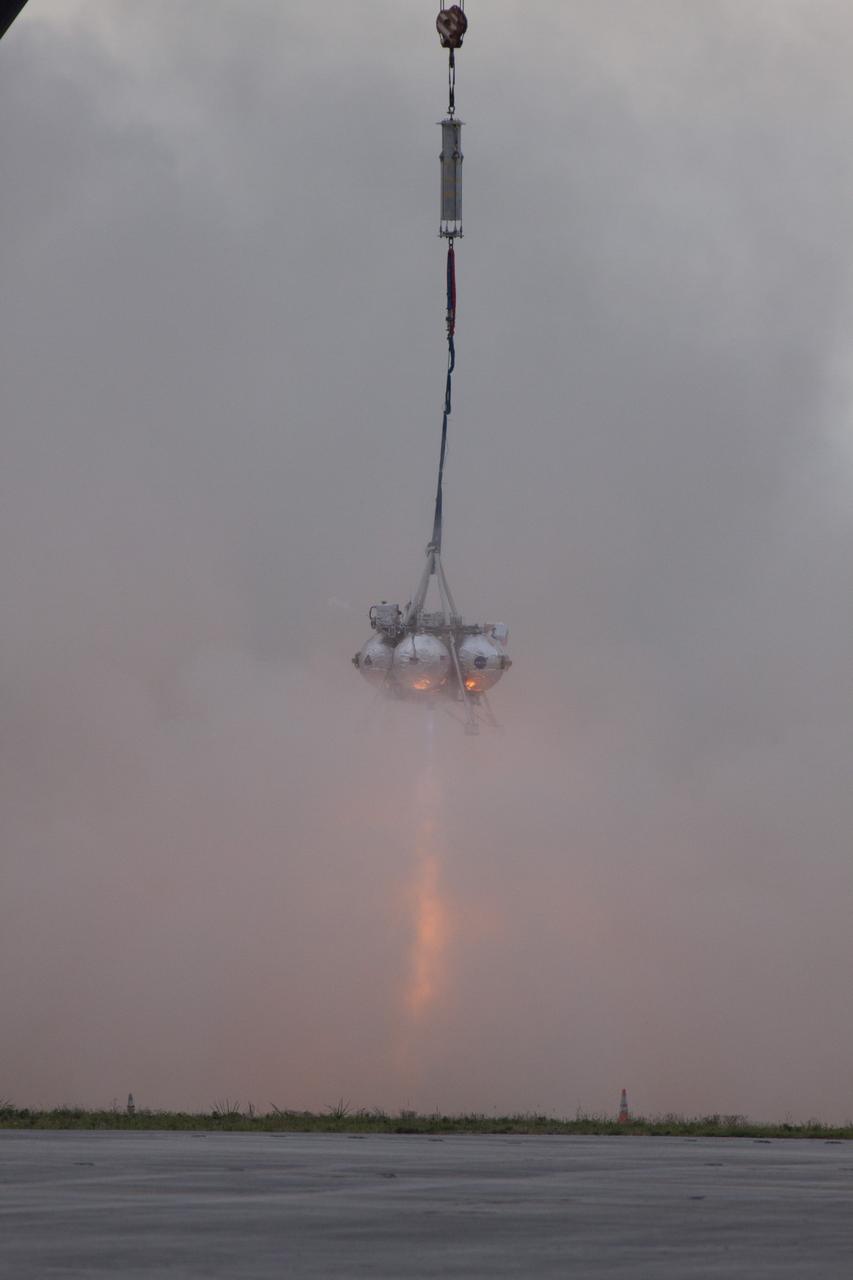
CAPE CANAVERAL, Fla. – NASA's Project Morpheus prototype lander is lifted by crane and its engine is ignited during a tethered test near a new launch site at the north end of the Shuttle Landing Facility at NASA's Kennedy Space Center in Florida. The launch pad was moved to a different location at the landing facility to support the next phase of flight testing. The test was performed to verify the lander's recently installed autonomous landing and hazard avoidance technology, or ALHAT, sensors and integration systems. During the test, Morpheus was lifted by crane to 20 feet for an engine firing of about 74 seconds and then lowered to the ground. With the successful completion of the test, the Morpheus project team will begin preparing for the first free flight test with ALHAT. Morpheus tests NASA’s ALHAT, and an engine that runs on liquid oxygen and methane, or green propellants, into a fully-operational lander that could deliver cargo to other planetary surfaces. The landing facility provides the lander with the kind of field necessary for realistic testing, complete with rocks, craters and hazards to avoid. Morpheus’ ALHAT payload allows it to navigate to clear landing sites amidst rocks, craters and other hazards during its descent. Project Morpheus is being managed under the Advanced Exploration Systems, or AES, Division in NASA’s Human Exploration and Operations Mission Directorate. The efforts in AES pioneer new approaches for rapidly developing prototype systems, demonstrating key capabilities and validating operational concepts for future human missions beyond Earth orbit. For more information on Project Morpheus, visit http://morpheuslander.jsc.nasa.gov/. Photo credit: NASA/Glenn Benson
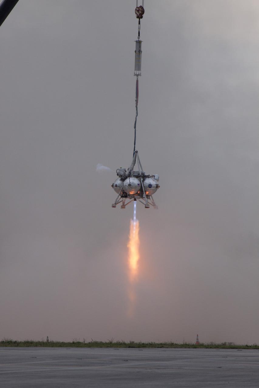
CAPE CANAVERAL, Fla. – NASA's Project Morpheus prototype lander is lifted by crane and its engine is ignited during a tethered test near a new launch site at the north end of the Shuttle Landing Facility at NASA's Kennedy Space Center in Florida. The launch pad was moved to a different location at the landing facility to support the next phase of flight testing. The test was performed to verify the lander's recently installed autonomous landing and hazard avoidance technology, or ALHAT, sensors and integration systems. During the test, Morpheus was lifted by crane to 20 feet for an engine firing of about 74 seconds and then lowered to the ground. With the successful completion of the test, the Morpheus project team will begin preparing for the first free flight test with ALHAT. Morpheus tests NASA’s ALHAT, and an engine that runs on liquid oxygen and methane, or green propellants, into a fully-operational lander that could deliver cargo to other planetary surfaces. The landing facility provides the lander with the kind of field necessary for realistic testing, complete with rocks, craters and hazards to avoid. Morpheus’ ALHAT payload allows it to navigate to clear landing sites amidst rocks, craters and other hazards during its descent. Project Morpheus is being managed under the Advanced Exploration Systems, or AES, Division in NASA’s Human Exploration and Operations Mission Directorate. The efforts in AES pioneer new approaches for rapidly developing prototype systems, demonstrating key capabilities and validating operational concepts for future human missions beyond Earth orbit. For more information on Project Morpheus, visit http://morpheuslander.jsc.nasa.gov/. Photo credit: NASA/Glenn Benson

CAPE CANAVERAL, Fla. – NASA's Project Morpheus prototype lander is lifted by crane and its engine is ignited during a tethered test near a new launch site at the north end of the Shuttle Landing Facility at NASA's Kennedy Space Center in Florida. The launch pad was moved to a different location at the landing facility to support the next phase of flight testing. The test was performed to verify the lander's recently installed autonomous landing and hazard avoidance technology, or ALHAT, sensors and integration systems. During the test, Morpheus was lifted by crane to 20 feet for an engine firing of about 74 seconds and then lowered to the ground. With the successful completion of the test, the Morpheus project team will begin preparing for the first free flight test with ALHAT. Morpheus tests NASA’s ALHAT, and an engine that runs on liquid oxygen and methane, or green propellants, into a fully-operational lander that could deliver cargo to other planetary surfaces. The landing facility provides the lander with the kind of field necessary for realistic testing, complete with rocks, craters and hazards to avoid. Morpheus’ ALHAT payload allows it to navigate to clear landing sites amidst rocks, craters and other hazards during its descent. Project Morpheus is being managed under the Advanced Exploration Systems, or AES, Division in NASA’s Human Exploration and Operations Mission Directorate. The efforts in AES pioneer new approaches for rapidly developing prototype systems, demonstrating key capabilities and validating operational concepts for future human missions beyond Earth orbit. For more information on Project Morpheus, visit http://morpheuslander.jsc.nasa.gov/. Photo credit: NASA/Glenn Benson