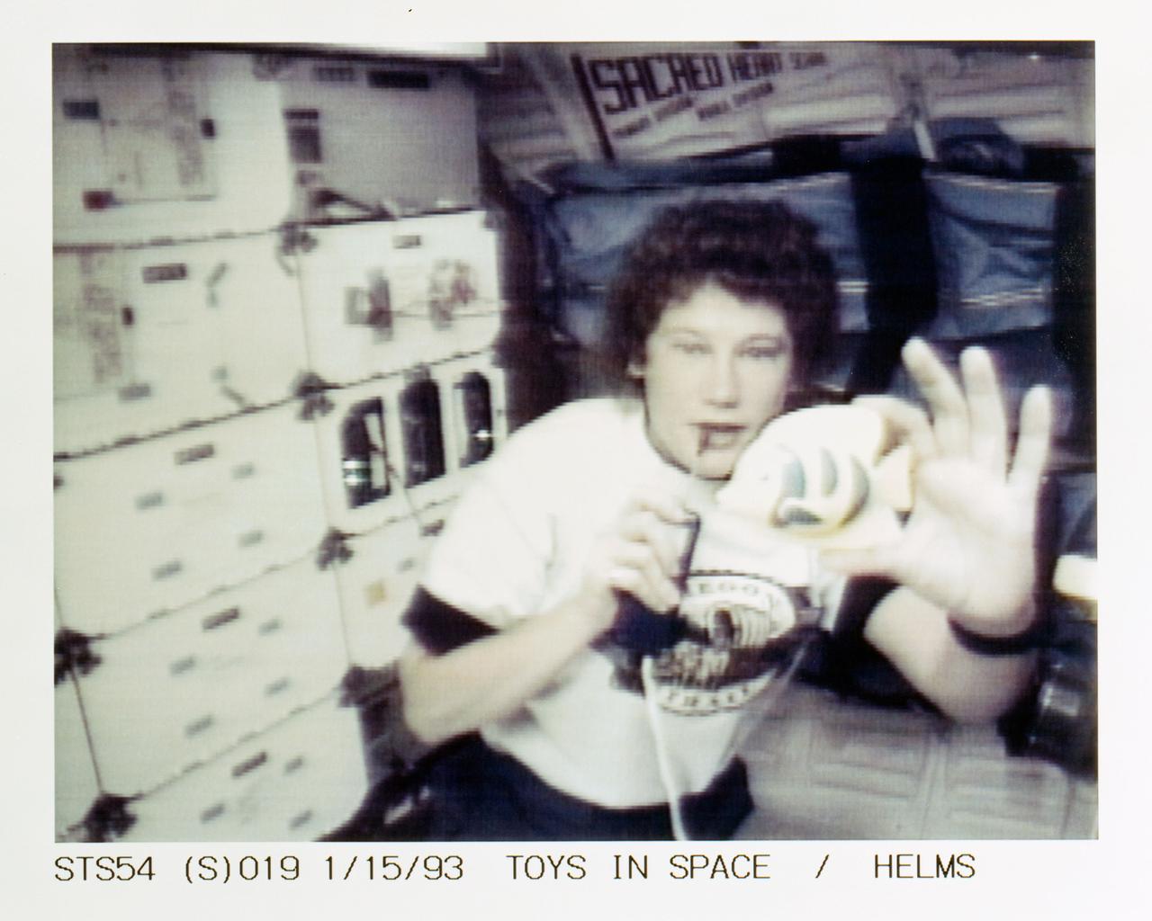
STS054-S-019 (15 Jan 1993) --- Helms with a fish toy on the middeck demonstrates some of the physics of toys to students watching on television. Four schools were chosen to ask questions of the astronauts during the lengthy program. Helms fielded questions from students at Shaver Elementary School in Portland, Oregon. The fish was used to demonstrate Newton's third law of motion and the conservation of angular momentum. The entire collection of toys will be videotaped for an educational program to be distributed to schools in the fall of this year. The scene was recorded at 17:50:08:27 GMT, Jan. 15, 1993.
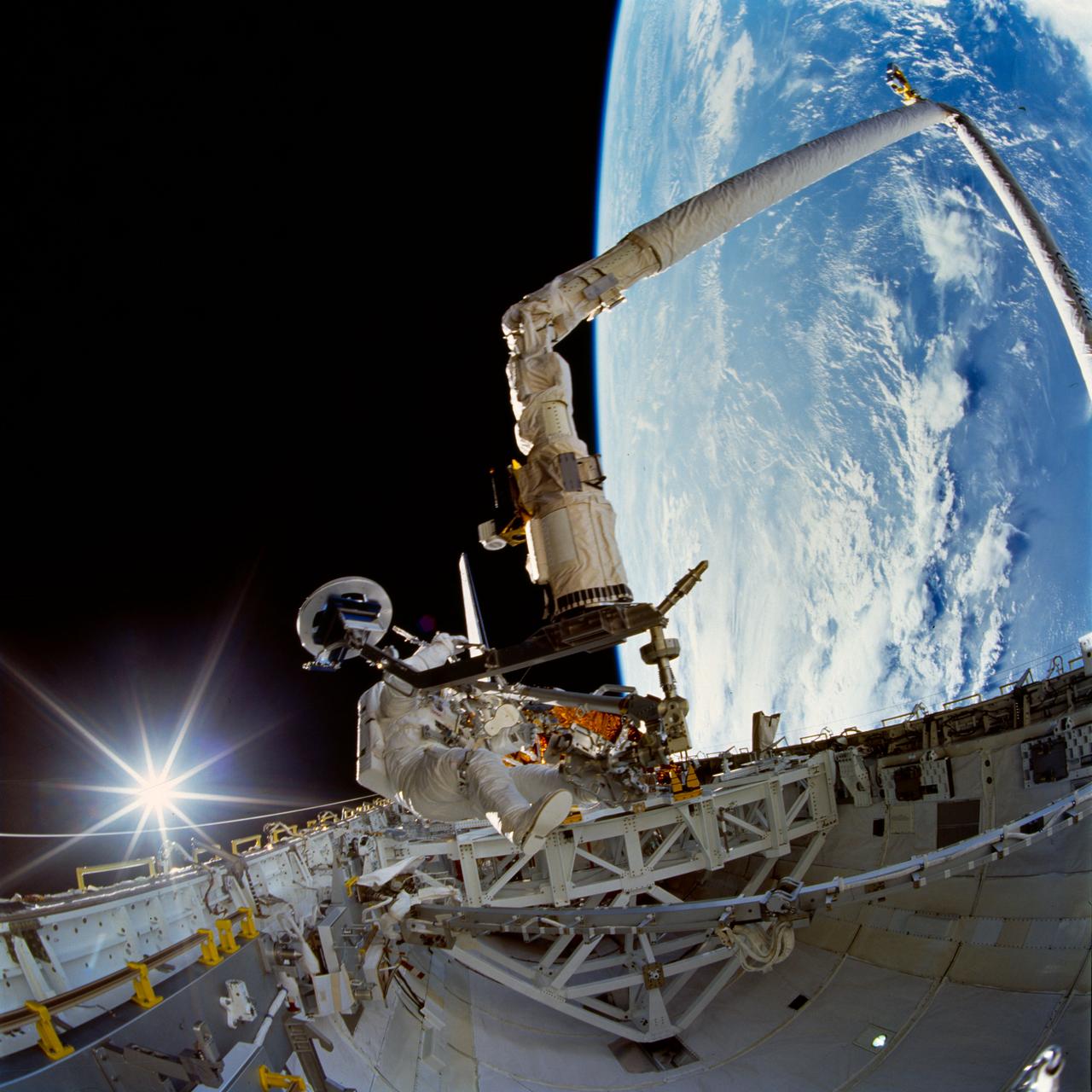
STS072-742-004 (15 Jan. 1996) --- Astronaut Daniel T. Barry, STS-72 mission specialist, tests a Temporary Equipment Restraint Aid (TERA) in the cargo bay of the Earth-orbiting space shuttle Endeavour. A reflection of the sun’s rays beam off Endeavour’s aft flight deck window in the “fish-eye” image. Barry was joined by astronaut Leroy Chiao for this first of two extravehicular activities (EVA) on the mission. A good part of the EVA was spent evaluating EVA hardware for future scheduled missions. Astronauts Chiao and Winston E. Scott participated in the second EVA two days later. Photo credit: NASA
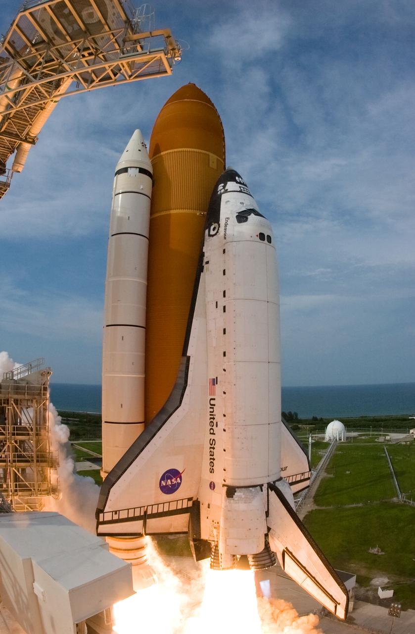
STS127-S-043 (15 July 2009) --- Captured by a remote camera equipped with a special "fish-eye" lens, Space Shuttle Endeavour and its seven-member STS-127 crew head toward Earth orbit and rendezvous with the International Space Station. Liftoff was on time at 6:03 p.m. (EDT) on July 15, 2009 from launch pad 39A at NASA?s Kennedy Space Center. Onboard are astronauts Mark Polansky, commander; Doug Hurley, pilot; Christopher Cassidy, Tom Marshburn, Dave Wolf, Tim Kopra and Canadian Space Agency?s Julie Payette, all mission specialists. Kopra will join Expedition 20 in progress to serve as a flight engineer aboard the ISS. Endeavour will deliver the Japanese Experiment Module's Exposed Facility and the Experiment Logistics Module-Exposed Section in the final of three flights dedicated to the assembly of the Japan Aerospace Exploration Agency's Kibo laboratory complex on the space station.
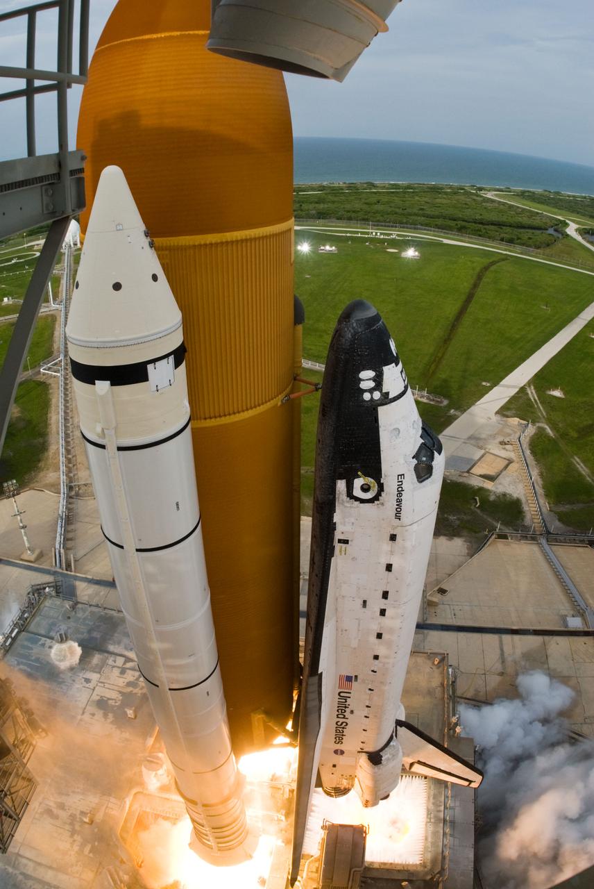
STS127-S-046 (15 July 2009) --- Captured by a remote camera equipped with a special "fish-eye" lens, Space Shuttle Endeavour and its seven-member STS-127 crew head toward Earth orbit and rendezvous with the International Space Station. Liftoff was on time at 6:03 p.m. (EDT) on July 15, 2009 from launch pad 39A at NASA?s Kennedy Space Center. Onboard are astronauts Mark Polansky, commander; Doug Hurley, pilot; Christopher Cassidy, Tom Marshburn, Dave Wolf, Tim Kopra and Canadian Space Agency?s Julie Payette, all mission specialists. Kopra will join Expedition 20 in progress to serve as a flight engineer aboard the ISS. Endeavour will deliver the Japanese Experiment Module's Exposed Facility and the Experiment Logistics Module-Exposed Section in the final of three flights dedicated to the assembly of the Japan Aerospace Exploration Agency's Kibo laboratory complex on the space station.
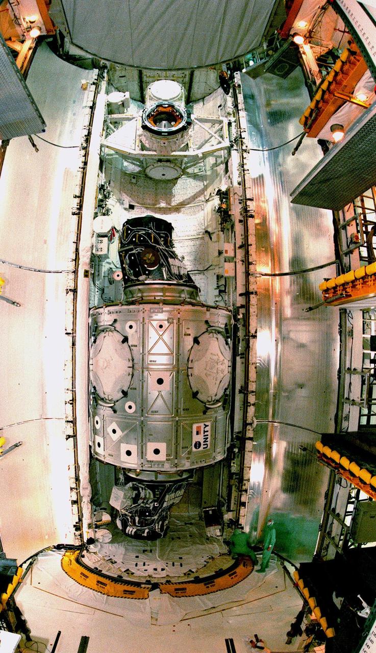
This fish-eye view of the Unity connecting module reveals its immense size relative to the workers (below right). Unity rests inside the open payload bay of the orbiter Endeavour on Launch Pad 39A. At the top of bay is the docking mechanism first used with launches to Mir, the Russian space station. Unity is the first U.S. element of the International Space Station (ISS) and is scheduled for launch Dec. 3, 1998, on Mission STS-88. The Unity is a connecting passageway to the living and working areas of ISS. While on orbit, the flight crew will deploy Unity from the payload bay and attach it to the Russian-built Zarya control module which will be in orbit at that time. The mission is expected to last nearly 12 days, landing back at the Kennedy Space Center on Dec. 14
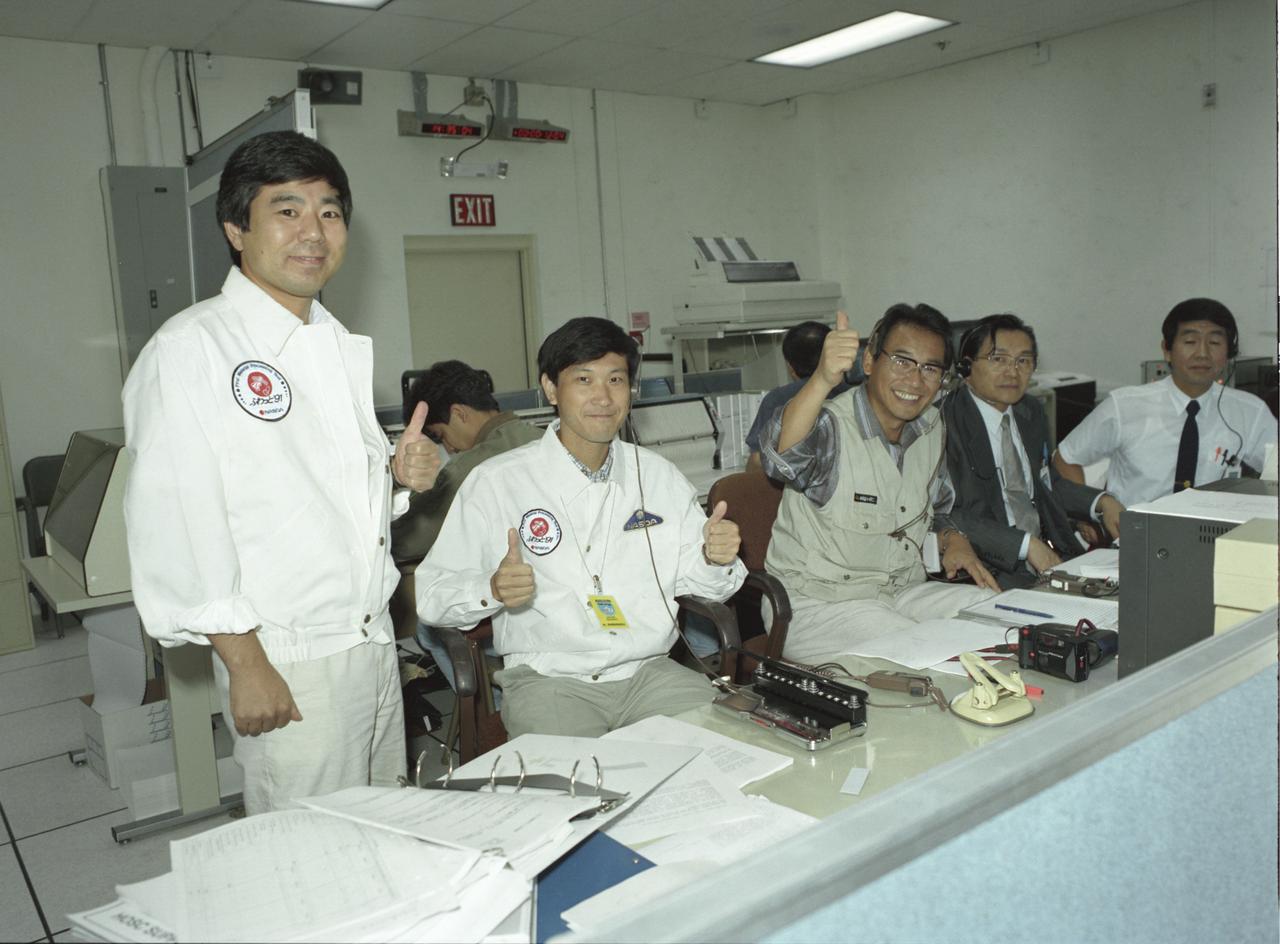
The group of Japanese researchers of the Spacelab-J (SL-J) were thumbs-up in the Payload Operations Control Center (POCC) at the Marshall Space Flight Center after the successful launch of Space Shuttle Orbiter Endeavour that carried their experiments. The SL-J was a joint mission of NASA and the National Space Development Agency of Japan (NASDA) utilizing a marned Spacelab module. The mission conducted microgravity investigations in materials and life sciences. Materials science investigations covered such fields as biotechnology, electronic materials, fluid dynamics and transport phenomena, glasses and ceramics, metals and alloys, and acceleration measurements. Life sciences included experiments on human health, cell separation and biology, developmental biology, animal and human physiology and behavior, space radiation, and biological rhythms. Test subjects included the crew, Japanese koi fish (carp), cultured animal and plant cells, chicken embryos, fruit flies, fungi and plant seeds, frogs, and frog eggs. The POCC was the air/ground communications channel between the astronauts and ground control teams during the Spacelab missions. The Spacelab science operations were a cooperative effort between the science astronaut crew in orbit and their colleagues in the POCC. Spacelab-J was launched aboard the Space Shuttle Orbiter Endeavour on September 12, 1992.
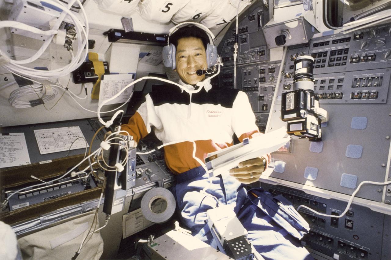
Japanese astronaut, Mamoru Mohri, talks to Japanese students from the aft flight deck of the Space Shuttle Orbiter Endeavour during the Spacelab-J (SL-J) mission. The SL-J mission was a joint venture between NASA and the National Space Development Agency of Japan (NASDA) utilizing a marned Spacelab module. The mission conducted 24 materials science and 20 life science experiments, of which 35 were sponsored by NASDA, 7 by NASA, and two collaborative efforts. Materials science investigations covered such fields as biotechnology, electronic materials, fluid dynamics and transport phenomena, glasses and ceramics, metals and alloys, and acceleration measurements. Life sciences included experiments on human health, cell separation and biology, developmental biology, animal and human physiology and behavior, space radiation, and biological rhythms. Test subjects included the crew, Japanese koi fish (carp), cultured animal and plant cells, chicken embryos, fruit flies, fungi and plant seeds, and frogs and frog eggs. Spacelab-J was launched aboard the Space Shuttle Orbiter Endeavour on September 12, 1992.
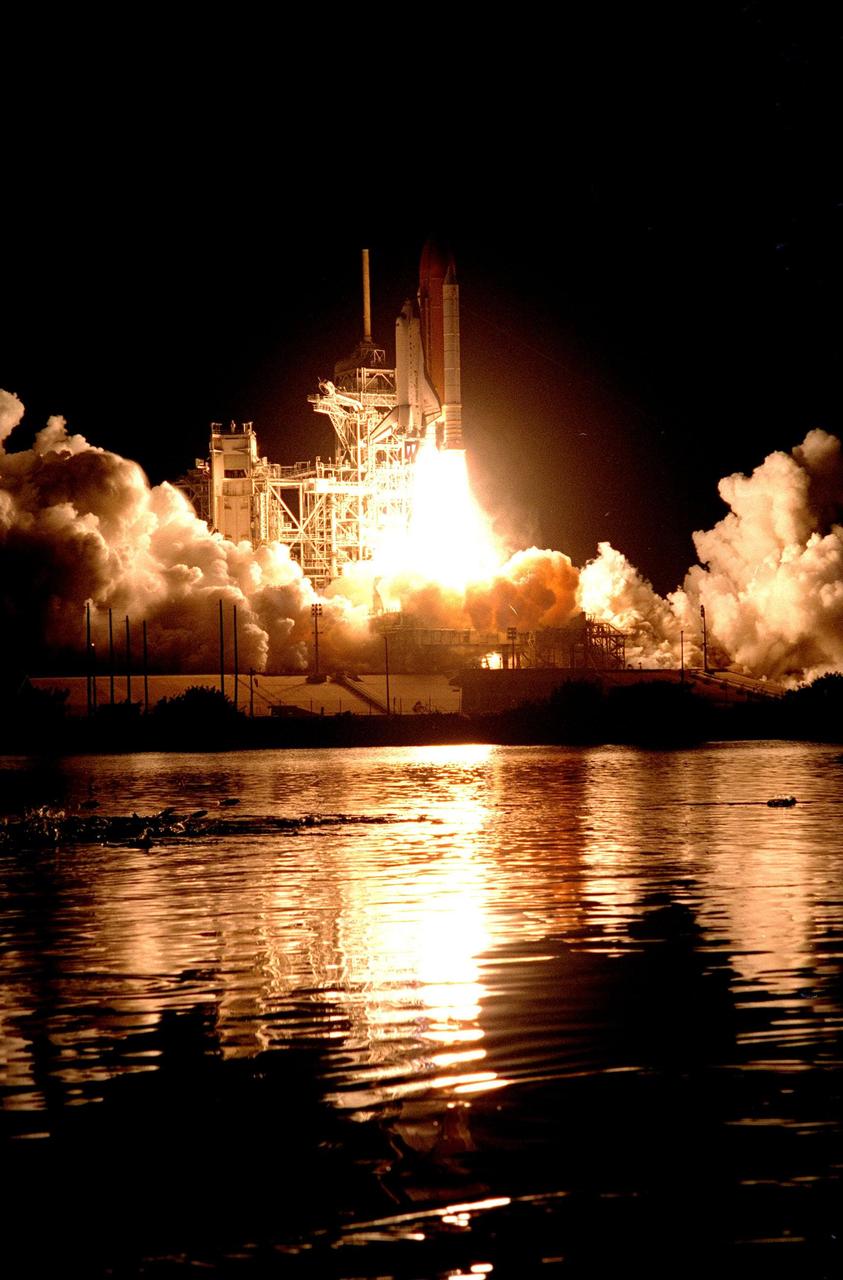
KENNEDY SPACE CENTER, Fla. -- As the Space Shuttle Endeavour lifts off from Launch Pad 39A on Mission STS-88, several fish believed to be mullet (at center left) "launch" themselves out of the water from one of the waterways around the pad. Liftoff of the first U.S. mission dedicated to the assembly of the International Space Station was at 3:35:34 a.m. EST on Dec. 4. During the nearly 12-day mission, the six-member crew will mate in space the first two elements of the International Space Station the already-orbiting Zarya control module with the Unity connecting module carried by Endeavour. Crew members are Commander Robert D. Cabana, Pilot Frederick W. "Rick" Sturckow, and Mission Specialists Nancy J. Currie, Jerry L. Ross, James H. Newman and Sergei Konstantinovich Krikalev, a Russian cosmonaut. This was the second launch attempt for STS-88. The first one on Dec. 3 was scrubbed when launch controllers, following an assessment of a suspect hydraulic system, were unable to resume the countdown clock in time to launch within the remaining launch window

STS059-S-039 (11 April 1994) --- This is a false-color composite of Prince Albert, Canada, centered at 53.91 north latitude and 104.69 west longitude. This image was acquired by the Spaceborne Imaging Radar-C and X-Band Synthetic Aperture Radar (SIR-C/X-SAR) aboard the Space Shuttle Endeavour on its 20th orbit. The area is located 40 kilometers (25 miles) north and 30 kilometers (20 miles) east of the town of Prince Albert in the Saskatchewan province of Canada. The image covers the area east of the Candle Lake, between gravel surface Highways 120 and 106 and west of 106. The area in the middle of the image covers the entire Nipawin (Narrow Hills) provincial park. The look angle of the radar is 30 degrees and the size of the image is approximately 20 kilometers by 50 kilometers (12 by 30 miles). The image was produced by using only the L-Band. The three polarization channels HH, HV and VV are illustrated by red, green and blue respectively. The changes in the intensity of each color are related to various surface conditions such as variations in forest stands, frozen or thawed condition of the surface, disturbances (fire and deforestation), and areas of re-growth. Most of the dark areas in the image are the ice-covered lakes in the region. The dark area on the top right corner of the image is the White Gull Lake north of the intersection of Highway 120 and 913. The right middle part of the image shows Lake Ispuchaw and Lower Fishing Lake. The deforested areas are also shown by dark areas in the image. Since most of the logging practice at the Prince Albert area is around the major highways, the deforested areas can be easily detected as small geometrically shaped dark regions along the roads. At the time of the SIR-C/X-SAR overpass, a major part of the forest is either frozen or undergoing the spring thaw. The L-Band HH shows a high return in the jack pine forest. The reddish areas in the image are old jack pine forest, 12-17 meters (40-55 feet) in height and 60-75 years old. The orange-greenish areas are young jack pine trees, 3-5 meters (10-16 feet) in height and 11-16 years old. The green areas are due to the relative high intensity of the HV channel which is strongly correlated with the amount of biomass. L-Band HV channel shows the biomass variations over the entire region. Most of the green areas, when compared to the forest cover maps are identified as black spruce trees. The dark blue and dark purple colors show recently harvested or re-growth areas respectively. SIR-C/X-SAR is part of NASA's Mission to Planet Earth (MTPE). SIR-C/X-SAR radars illuminate Earth with microwaves allowing detailed observations at any time, regardless of weather or sunlight conditions. SIR-C/X-SAR uses three microwave wavelengths: L-Band (24 cm), C-Band (6 cm), and X-Band (3 cm). The multi-frequency data will be used by the international scientific community to better understand the global environment and how it is changing. The SIR-C/X-SAR data, complemented by aircraft and ground studies, will give scientists clearer insights into those environmental changes which are caused by nature and those changes which are induced by human activity. SIR-C was developed by NASA's Jet Propulsion Laboratory (JPL). X-SAR was developed by the Dornire and Alenia Spazio Companies for the German Space Agency, Deutsche Agentur fuer Raumfahrtangelegenheiten (DARA), and the Italian Space Agency, Agenzia Spaziale Italiana (ASI). JPL Photo ID: P-43886
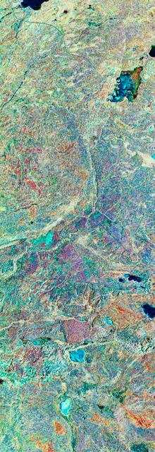
STS059-S-079 (18 April 1994) --- This is a false-color, three frequency image of Prince Albert, Canada, centered at 53.91 north latitude and 104.69 west longitude. It was produced using data from the X-Band, C-Band and L-Band radars that comprise the Spaceborne Imaging Radar-C and X-Band Synthetic Aperture Radar (SIR-C/X-SAR). SIR-C/X-SAR acquired this image on the 20th orbit of the Space Shuttle Endeavour. The area is located 40 kilometers north and 30 kilometers east of the town of Prince Albert in the Saskatchewan province of Canada. The image covers the area east of the Candle Lake, between gravel surface Highways 120 and 106 and west of 106. The area in the middle of the image covers the entire Nipawin (Narrow Hills) provincial park. The look angle of the radar is 30 degrees and the size of the image is approximately 20 by 50 kilometers. The red, green, and blue colors represent L-Band total power, C-Band total power, and XVV respectively. The changes in the intensity of each color are related to various surface conditions such as frozen or thawed forest, fire, deforestation and areas of regrowth. Most of the dark blue areas in the image are the ice covered lakes. The dark area on the top right corner of the image is the White Gull Lake north of the intersection of Highway 120 and 913. The right middle part of the image shows Lake Ispuchaw and Lower Fishing Lake. The deforested areas are shown by light blue in the image. Since most of the logging practice at the Prince Albert area is around the major highways, the deforested areas can be easily detected as small geometrically shaped dark regions along the roads. At the time these data were taken, a major part of the forest was either frozen or undergoing the spring thaw. In such conditions, due to low volume of water in the vegetation, a deeper layer of the canopy is imaged by the radar, revealing valuable information about the type of trees, the amount of vegetation biomass and the condition of the surface. As the frequency increases, the penetration depth in the canopy decreases. Over forest canopies, the X-Band radar contains information about the top of the canopy. Whereas, C-Band and L-Band radar returns show contributions from the crown and trunk areas respectively. The bright areas in the image are dense mixed aspen and old jackpine forests where the return from all three bands is high. The reddish area corresponds to more sparse old jack pine (12 to 17 meters in height and 60 to 75 years old) where the L-Band signal penetrates deeper in the canopy and dominates C-Band and X-Band returns. Comparison of the image with the forest cover map of the area indicates that the three band radar can be used to classify various stands. SIR-C/X-SAR is part of NASA's Mission to Planet Earth (MTPE). SIR-C/X-SAR radars illuminate Earth with microwaves allowing detailed observations at any time, regardless of weather or sunlight conditions. SIR-C/X-SAR uses three microwave wavelengths: L-Band (24 cm), C-Band (6 cm), and X-Band (3 cm). The multi-frequency data will be used by the international scientific community to better understand the global environment and how it is changing. The SIR-C/X-SAR data, complemented by aircraft and ground studies, will give scientists clearer insights into those environmental changes which are caused by nature and those changes which are induced by human activity. SIR-C was developed by NASA's Jet Propulsion Laboratory (JPL). X-SAR was developed by the Dornire and Alenia Spazio Companies for the German Space Agency, Deutsche Agentur fuer Raumfahrtangelegenheiten (DARA), and the Italian Space Agency, Agenzia Spaziale Italiana (ASI). JPL Photo ID: P-43929