
STS001-12-308 (12-14 April 1981) --- Space shuttle Columbia approached Edwards Air Force Base from the left to land at the dry lake at the center. The view is to the southwest. The edge of the light "vee" is the intersection of the San Andres and Garlock Faults at Fort Tejon. Los Angeles is at upper right. Owens Lake is at the lower center. Photo credit: NASA
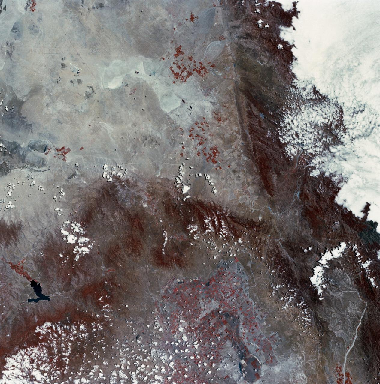
SL2-03-126 (June 1973) --- A color infrared photograph of the Los Angeles County and Kern County area, taken from the Skylab space station in Earth orbit during its first manned Skylab mission. The Mojave Desert occupies the northeast one-fourth of the photograph. Lake Isabella in the Sierra Nevada Mountains is the v-shaped body of water. The San Gabriel Mountains extend across the southern part of the picture. At lower center is the intersection of the San Andreas and Garlock faults. The San Joaquin Valley is in the center at the left edge. (The picture should be held with the heavy cloud cover at lower right corner so that north will be at top.) This picture was exposed by one of the six lenses of the Itek-furnished S190-A Multispectral Photographic Facility experiment in the Multiple Docking Adapter of the Skylab space station. Type 2443 film was used. Photo credit: NASA
STS054-151-015 (13-19 Jan 1993) --- The Makgadikgadi Salt Pan is one of the largest features in Botswana visible from space. Any water that spills out of the Okavango Swamplands flows down to the Makgadikgadi where it evaporates. An ancient beach line can be seen as a smooth line around the west (left) side of the Pan. Orapa diamond mine can be detected due south of the pan as a small rectangle. The large geological feature known as the Great Dike of Zimbabwe can be seen far right. This large panorama shows clouds in southern Angola, Zambia and Zimbabwe in the distance.
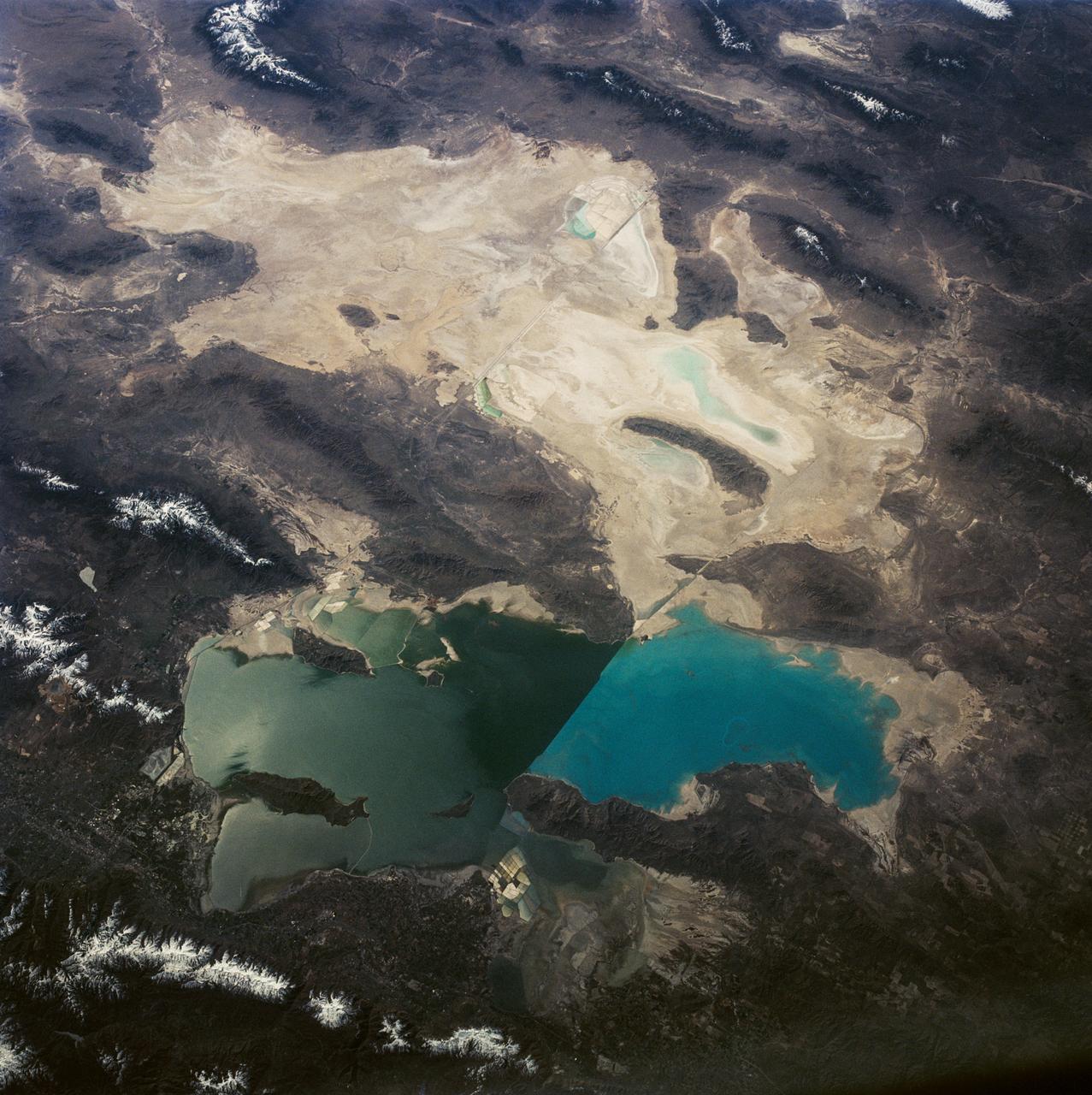
This is a view of the Great Salt Lake and nearby Bonneville Salt Flats, UT, (41.0N, 112.5W). A railroad causeway divides the lake with a stark straight line changing the water level and chemistry of the lake as a result. Fresh water runoff enters from the south adding to the depth and reducing the salinity. The north half receives little frsh water and is more saline and shallow. The Bonnieville Salt Flats is the lakebed of a onetime larger lake.
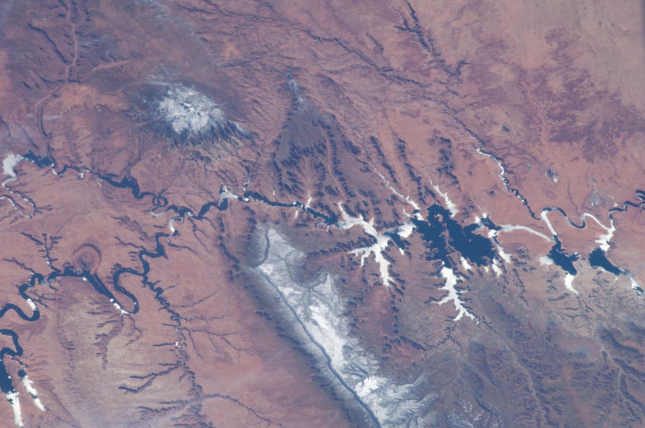
ISS034-E-066804 (12 March 2013) --- One of the Expedition 34 crew members aboard the Earth-orbiting International Space Station on March 12 , 2013 photographed this image of the Colorado Plateau, which spans northern Arizona, southern Utah, northwestern New Mexico and southwestern Colorado. This physiographic province is well known for its striking landscapes and broad vistas—an impression that is enhanced by the view from the orbital perspective of the space station. The image highlights part of the Utah-Arizona border region of the plateau and includes several prominent landforms. The Colorado River, dammed to form Lake Powell in 1963, crosses from east to west, (which is actually left to right in this image because the view looks toward the south, and north appears toward the bottom of the frame). The confluence of the Colorado and San Juan Rivers is also visible in the image. Sunglint, or sunlight reflected off a water surface back toward the observer, provides a silvery. Mirror-like sheen to some areas of the water surfaces. The geologic uplift of the Colorado Plateau led to rapid down cutting of rivers into the flat sedimentary bedrock, leaving spectacular erosional landforms. One such feature – the Rincon ---preserves evidence of a former meander bend of the Colorado River. Photo credit: NASA
This image shows the dissected interior of a crater in the Cydonia region of Mars. The flat-topped buttes and mesas in the northern portion of the image were once a continuous layer of material that filled the crater. Since deposition, the material has been disturbed and dissected. The process that causes such landforms is not well known, but likely involves frozen subsurface water that may have found its way to the surface. The surfaces on the mesas are not rough, suggesting that the whole scene is mantled with fine dust, masking the details that may give clues to whether surface water was involved at some point in the past. Small recent channels can be seen in the lower left. This is an indication of relatively recent small-scale surface activity, which has been could have been volcanic, fluvial, or some process involving subsurface volatiles (ice). http://photojournal.jpl.nasa.gov/catalog/PIA04030
This image is illuminated by sunlight from the upper left. Looking like pieces of sliced and broken swiss cheese, the upper layer of the martian south polar residual cap has been eroded, leaving flat-topped mesas into which are set circular depressions such as those shown here. The circular features are depressions, not hills. The largest mesas here stand about 4 meters (13 feet) high and may be composed of frozen carbon dioxide and/or water. Nothing like this has ever been seen anywhere on Mars except within the south polar cap, leading to some speculation that these landforms may have something to do with the carbon dioxide thought to be frozen in the south polar region. On Earth, we know frozen carbon dioxide as "dry ice." On Mars, as this picture might be suggesting, there may be entire landforms larger than a small town and taller than 2 to 3 men and women that consist, in part, of dry ice. No one knows for certain whether frozen carbon dioxide has played a role in the creation of the "swiss cheese" and other bizarre landforms seen in this picture. The picture covers an area 3 x 9 kilometers (1.9 x 5.6 miles) near 85.6°S, 74.4°W at a resolution of 7.3 meters (24 feet) per pixel. This picture was taken by the Mars Global Surveyor (MGS) Mars Orbiter Camera (MOC) during early southern spring on August 3, 1999. http://photojournal.jpl.nasa.gov/catalog/PIA02367
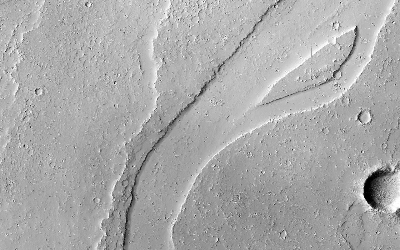
The Tharsis region of Mars is covered in vast lava flows, many with channels. Some channels, however, resemble features that may have been formed by water. In this image, we see a smooth, flat-bottomed channel within the roughly irregular edges of a possible lava flow. This long, winding channel runs for 115 kilometers (70 miles) from its source (shown in ESP_045091_2045), maintaining a nearly consistent width. There is also a streamlined island within the channel, which is 1.25 kilometers (about 3/4 mile) long. One possibility is that a lava flow formed, and later groundwater was released, preferentially flowing through and further eroding the pre-existing lava channel. Or, the original lava flow could have been a very low-viscosity lava. We look at the shape and profile of the channel, and the channel and lava flow edges, to understand the characteristics of the fluids at work. Although there are lava flows and rivers on Earth that we can observe to understand the processes at work, the interplay of the features on Mars may tell a more complicated story. We want to be able to understand the history of volcanic activity in Tharsis, as well as possible interaction with ground water release, to better understand some of the younger landforms on Mars. http://photojournal.jpl.nasa.gov/catalog/PIA21104
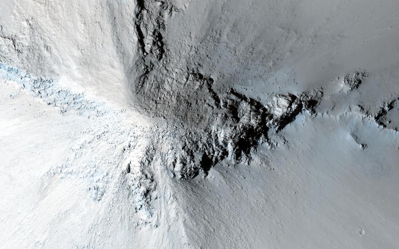
There are many hills and knobs on Mars that reveal aspects of the local geologic history. Typically, the hills in the relatively-smooth region surrounding this image are flat topped erosional remnants or mesas with irregular or even polyhedral margins. These landforms suggest wide spread erosion of the soft or weakly-cemented sedimentary layers. This hill stands out because of is circular inverted-cone shape and apparent dark streaks along its flanks visible in lower resolution images. Close inspection from HiRISE reveals that the fine soils sloping down from the peak are intersected with radiating lines of rock and eroding rubble. This formation is similar to lava intrusions that form in the core of a volcano. As lava is squeezed up into a central conduit, radiating fractures fill with lava forming rock units called dikes. As the lava cools inside the ground and in the fractures, it forms into a harder rock that is more resistant to erosion. Later, as the surrounding sediments and soils erode, the resistant volcanic rock remains standing to tell a story of what happened underground long ago. http://photojournal.jpl.nasa.gov/catalog/PIA20003
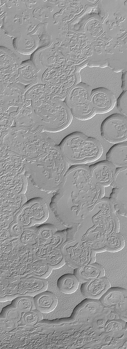
![Hellas is an ancient impact structure and is the deepest and broadest enclosed basin on Mars. It measures about 2,300 kilometers across and the floor of the basin, Hellas Planitia, contains the lowest elevations on Mars. The Hellas region can often be difficult to view from orbit due to seasonal frost, water-ice clouds and dust storms, yet this region is intriguing because of its diverse, and oftentimes bizarre, landforms. This image from eastern Hellas Planitia shows some of the unusual features on the basin floor. These relatively flat-lying "cells" appear to have concentric layers or bands, similar to a honeycomb. This "honeycomb" terrain exists elsewhere in Hellas, but the geologic process responsible for creating these features remains unresolved. The map is projected here at a scale of 50 centimeters (19.7 inches) per pixel. [The original image scale is 52.2 centimeters (20.6 inches) per pixel (with 2 x 2 binning); objects on the order of 157 centimeters (61.8 inches) across are resolved.] North is up. http://photojournal.jpl.nasa.gov/catalog/PIA21570](https://images-assets.nasa.gov/image/PIA21570/PIA21570~medium.jpg)
Hellas is an ancient impact structure and is the deepest and broadest enclosed basin on Mars. It measures about 2,300 kilometers across and the floor of the basin, Hellas Planitia, contains the lowest elevations on Mars. The Hellas region can often be difficult to view from orbit due to seasonal frost, water-ice clouds and dust storms, yet this region is intriguing because of its diverse, and oftentimes bizarre, landforms. This image from eastern Hellas Planitia shows some of the unusual features on the basin floor. These relatively flat-lying "cells" appear to have concentric layers or bands, similar to a honeycomb. This "honeycomb" terrain exists elsewhere in Hellas, but the geologic process responsible for creating these features remains unresolved. The map is projected here at a scale of 50 centimeters (19.7 inches) per pixel. [The original image scale is 52.2 centimeters (20.6 inches) per pixel (with 2 x 2 binning); objects on the order of 157 centimeters (61.8 inches) across are resolved.] North is up. http://photojournal.jpl.nasa.gov/catalog/PIA21570

This image shows a bright, rectangular-looking landform surrounded by a dark floor. How did this feature get here if it looks so different than its surroundings? The feature resembles a plateau. Dark streaks mark steep slopes on its sides while the top appears flat. The slope streaks are not all the same age, as we see a variation in colors from faint to dark. Craters in a variety of sizes and ages pepper the entire rectangle, but the dark, textured floor has very few noticeable craters. The evidence suggests that this rectangular feature is a high-standing "island" of older land surrounded by one or more younger lava flows. This landmass is located in Amazonis Planitia, a smooth plains area potentially formed by large-scale lava floods between the Tharsis and Elysium volcanic regions. As lava flowed into this area, the rectangular plateau was too high to cover completely, leaving a bright spot sticking out of the dark basalt floor for us to find. https://photojournal.jpl.nasa.gov/catalog/PIA22725
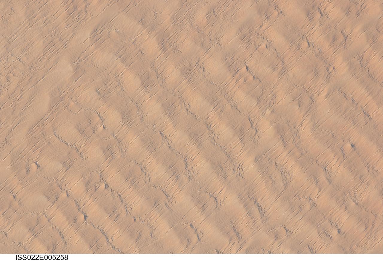
ISS022-E-005258 (1 Dec. 2009) --- This detailed hand-held digital camera?s image recorded from the International Space Station highlights sand dunes in the Fachi-Bilma erg, or sand sea, which is part of the central eastern Tenere Desert. The Tenere occupies much of southeastern Niger and is considered to be part of the larger Sahara Desert that stretches across northern Africa. Much of the Sahara is comprised of ergs ? with an area of approximately 150,000 square kilometers, the Fachi-Bilma is one of the larger sand seas. Two major types of dunes are visible in the image. Large, roughly north-south oriented transverse dunes fill the image frame. This type of dune tends to form at roughly right angles to the dominant northeasterly winds. The dune crests are marked in this image by darker, steeper sand accumulations that cast shadows. The lighter-toned zones between are lower interdune ?flats?. The large dunes appear to be highly symmetrical with regard to their crests. This suggests that the crest sediments are coarser, preventing the formation of a steeper slip face on the downwind side of the dune by wind-driven motion of similarly-sized sand grains. According to NASA scientists, this particular form of transverse dune is known as a zibar, and is thought to form by winnowing of smaller sand grains by the wind, leaving the coarser grains to form dune crests. A second set of thin linear dunes oriented at roughly right angles to the zibar dunes appears to be formed on the larger landforms and is therefore a younger landscape feature. These dunes appear to be forming from finer grains in the same wind field as the larger zibars. The image was taken with digital still camera fitted with a 400 mm lens, and is provided by the ISS Crew Earth Observations experiment and Image Science & Analysis Laboratory, Johnson Space Center.
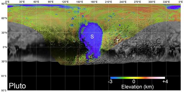
On July 14, 2015, NASA's New Horizons spacecraft made its historic flight through the Pluto system. This detailed, high-quality global mosaic of Pluto was assembled from nearly all of the highest-resolution images obtained by the Long-Range Reconnaissance Imager (LORRI) and the Multispectral Visible Imaging Camera (MVIC) on New Horizons. The mosaic is the most detailed and comprehensive global view yet of Pluto's surface using New Horizons data. It includes topography data of the hemisphere visible to New Horizons during the spacecraft's closest approach. The topography is derived from digital stereo-image mapping tools that measure the parallax -- or the difference in the apparent relative positions -- of features on the surface obtained at different viewing angles during the encounter. Scientists use these parallax displacements of high and low terrain to estimate landform heights. The global mosaic has been overlain with transparent, colorized topography data wherever on the surface stereo data is available. Terrain south of about 30°S was in darkness leading up to and during the flyby, so is shown in black. Examples of large-scale topographic features on Pluto include the vast expanse of very flat, low-elevation nitrogen ice plains of Sputnik Planitia ("P") -- note that all feature names in the Pluto system are informal -- and, on the eastern edge of the encounter hemisphere, the aligned, high-elevation ridges of Tartarus Dorsa ("T") that host the enigmatic bladed terrain, mountains, possible cryovolcanos, canyons, craters and more. https://photojournal.jpl.nasa.gov/catalog/PIA21861
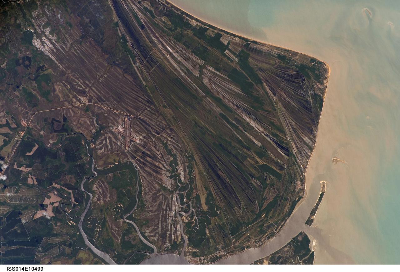
ISS014-E-10499 (23 Dec. 2006) --- Caravelas strandplain, Bahia Province, Brazil is featured in this image photographed by an Expedition 14 crewmember on the International Space Station. This view highlights a flat coastal landform known as a strandplain, or ancient shoreline. The image is dominated by numerous, fine parallel lines (trending diagonally from upper left to lower right), each of which is an ancient shoreline made up of sand transported from rivers to the north. The strandplain has been generated by these narrow shorelines accumulating against one another, line by line in their dozens or even hundreds, over thousands of years. The shorelines can be grouped into at least four packets depending on the crosscutting relationships - younger packets will cut into or stratigraphically overlay older packets. These relationships indicate that the youngest packet lies nearest the coast (furthest right) and the oldest packet lies north of the city of Caravelas (bottom). The Caravelas River flows into the Atlantic Ocean at the bottom of the view. Sediment from this river, and from the current shoreline, produces the light browns and dun colors visible offshore. On the day this image was taken the river water was relatively clear; clear water (gray) is visible flowing out of the main river mouth, and also off to one side to the south over a levee. The Caravelas airport appears near the middle of the view, and is built on one of the ancient shoreline packets. Caravelas itself, a fishing town of about 20,000 inhabitants, lies on an estuary and was once a flourishing whaling center--the prominent cape at top right is known as Ponta da Baleia (Whale Point).

ISS031-E-030783 (11 May 2012) --- Linear dunes in the Great Sand Sea in southwest Egypt are featured in this image photographed by an Expedition 31 crew member on the International Space Station. In southwestern Egypt, deep in the Sahara Desert, the action of wind dominates landscapes today much as it has done for the past several thousand years. Winds blowing from the north have fashioned sands into large dunes, aligned parallel with these winds. The so-called linear dunes?shown here in the Great Sand Sea?are easily seen from space and local maps show that they rise 20?30 meters above the surrounding flat plains. The distance between individual linear dunes is interestingly regular, at 1.5?2.5 kilometers, suggesting some equilibrium exists between the formative wind strength and the sand supply. It is possible that linear dunes may relate to earlier times when winds were stronger than they are today, or sand more plentiful. The dark patch of rock outcrop at upper right sticks up above the surface on which the dunes lie by as much as 150 meters. The north winds have been deflected around this high zone, and smaller secondary linear dunes can be seen along the right side of the image, aligned with local winds that become ever more northeasterly with nearness to the outcrops. A dune-free zone on the protected downwind (south-southeast) side of the outcrop gives a sense of the sand movement (generally from the bottom of the image towards the top). At first glance, the large linear dunes appear to be the major landform in the image; however a complex pattern of even smaller dunes can be seen perched on top of the largest dunes (inset). The sand that comprises many dune fields usually, according to scientists, derives from some larger river not very distant upwind, supplied from the dry river bed (exposed to the wind during dry seasons of low river flow, or regional change to a more arid climate). Inland dune fields thus lie downwind of the source river. A large, unnamed river once flowed to the Mediterranean Sea situated west of the dunes shown in this picture, dumping its sand load 300 kilometers northwest of the area shown. It is likely that this river, the evidence of which is now almost completely obliterated, was the source of the sand in the linear dunes, the scientists say.