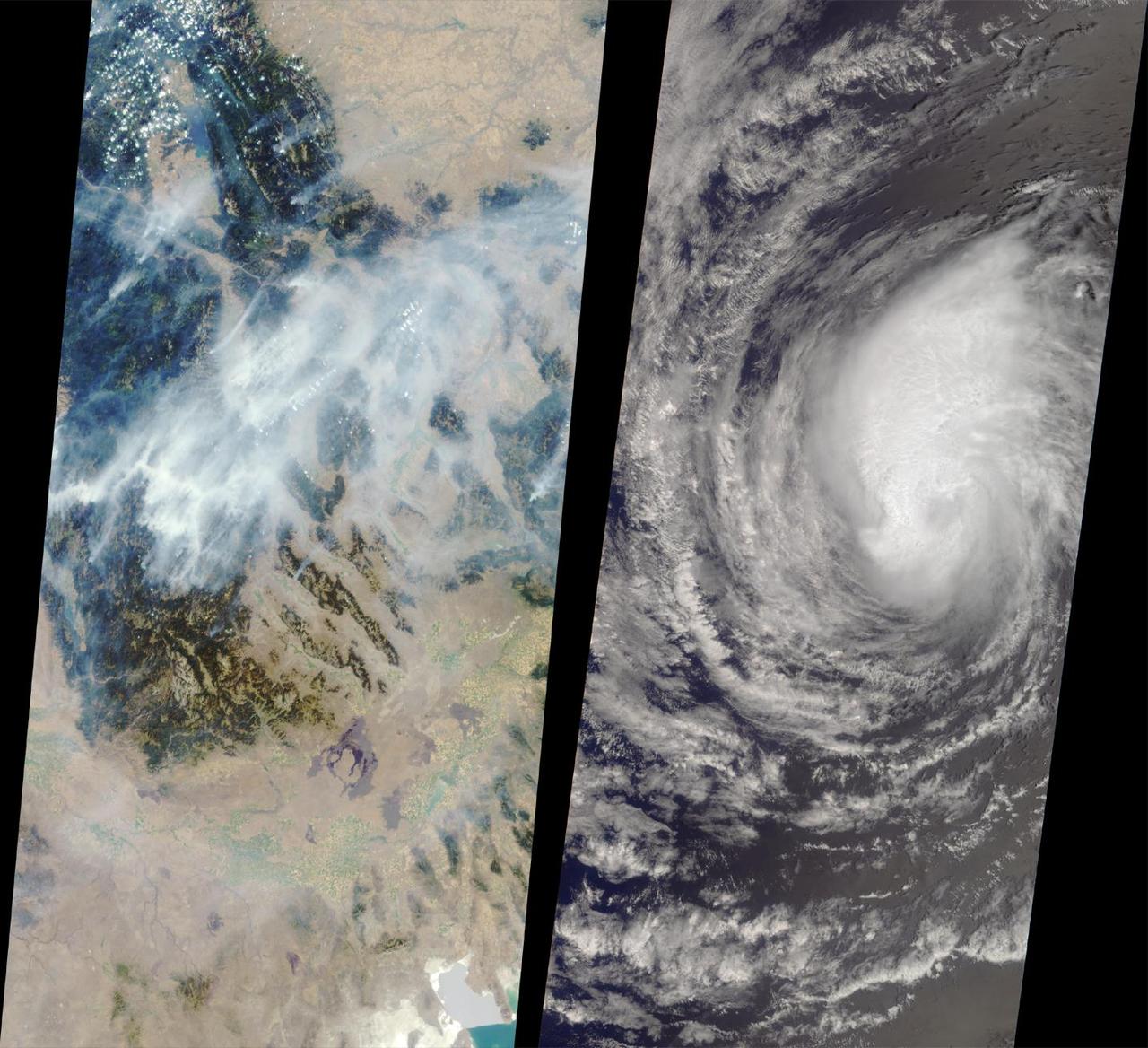
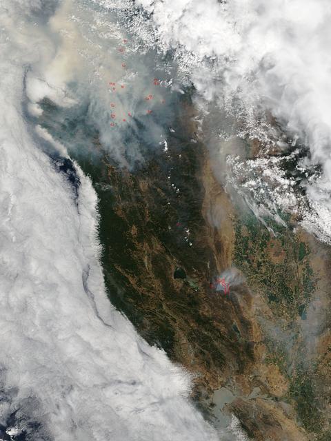
These images from NASA Terra satellite captured on August 14, 2000 show forest fires raging in Montana and Hurricane Hector swirling in the Pacific.
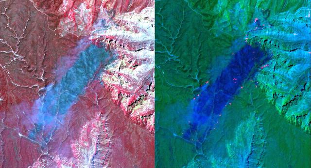
These ASTER images cover an area of 11 x 14 km on the north rim of the Grand Canyon, Arizona, and were acquired May 12, 2000. The left image displays bands 3,2,1 in RGB, displaying vegetation as red. The large dark area is burned forest, and small smoke plumes can be seen at the edges where active fires are burning. The right display substitutes SWIR band 8 for band 3. The bright red spots are the active fires, visible because the SWIR wavelength region has the capability to penetrate through the smoke. This image is located at 35.9 degrees north latitude and 113.4 degrees west longitude. http://photojournal.jpl.nasa.gov/catalog/PIA11092
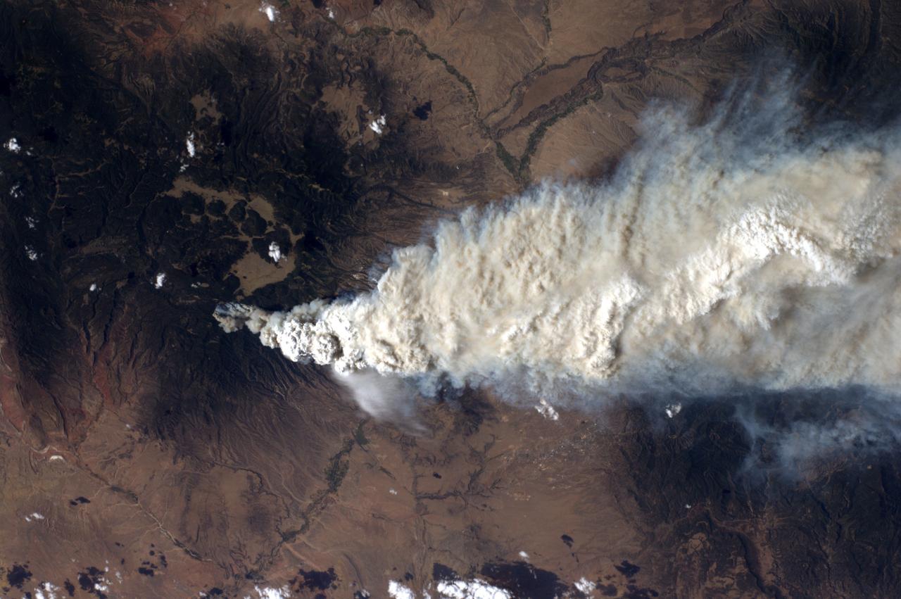
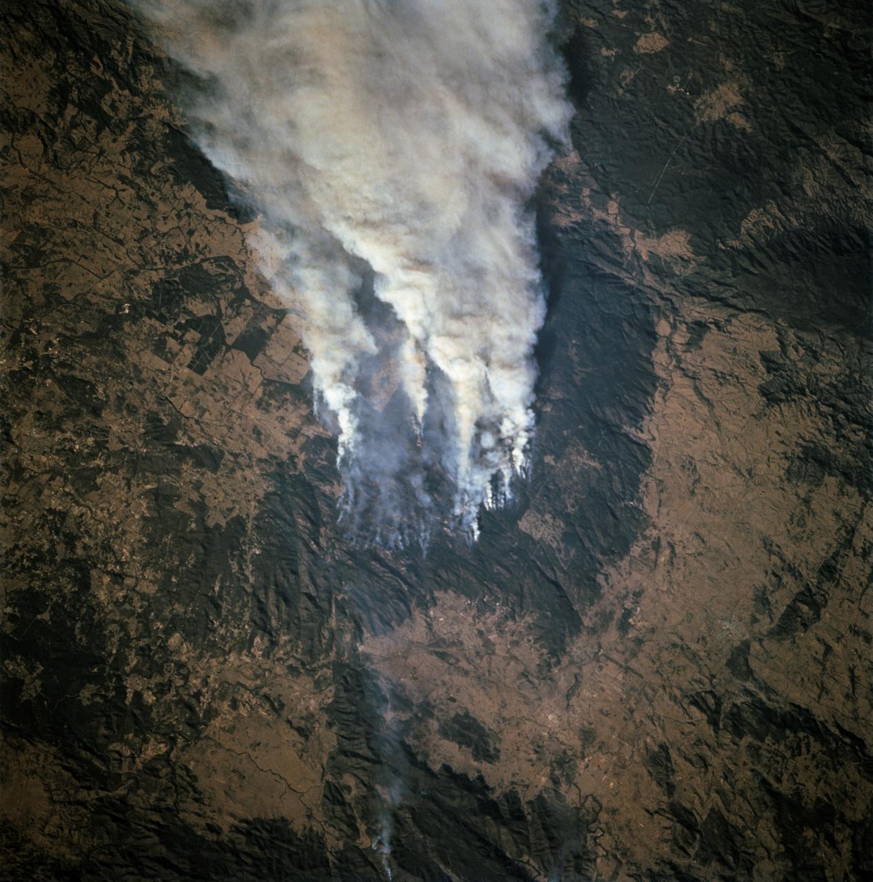
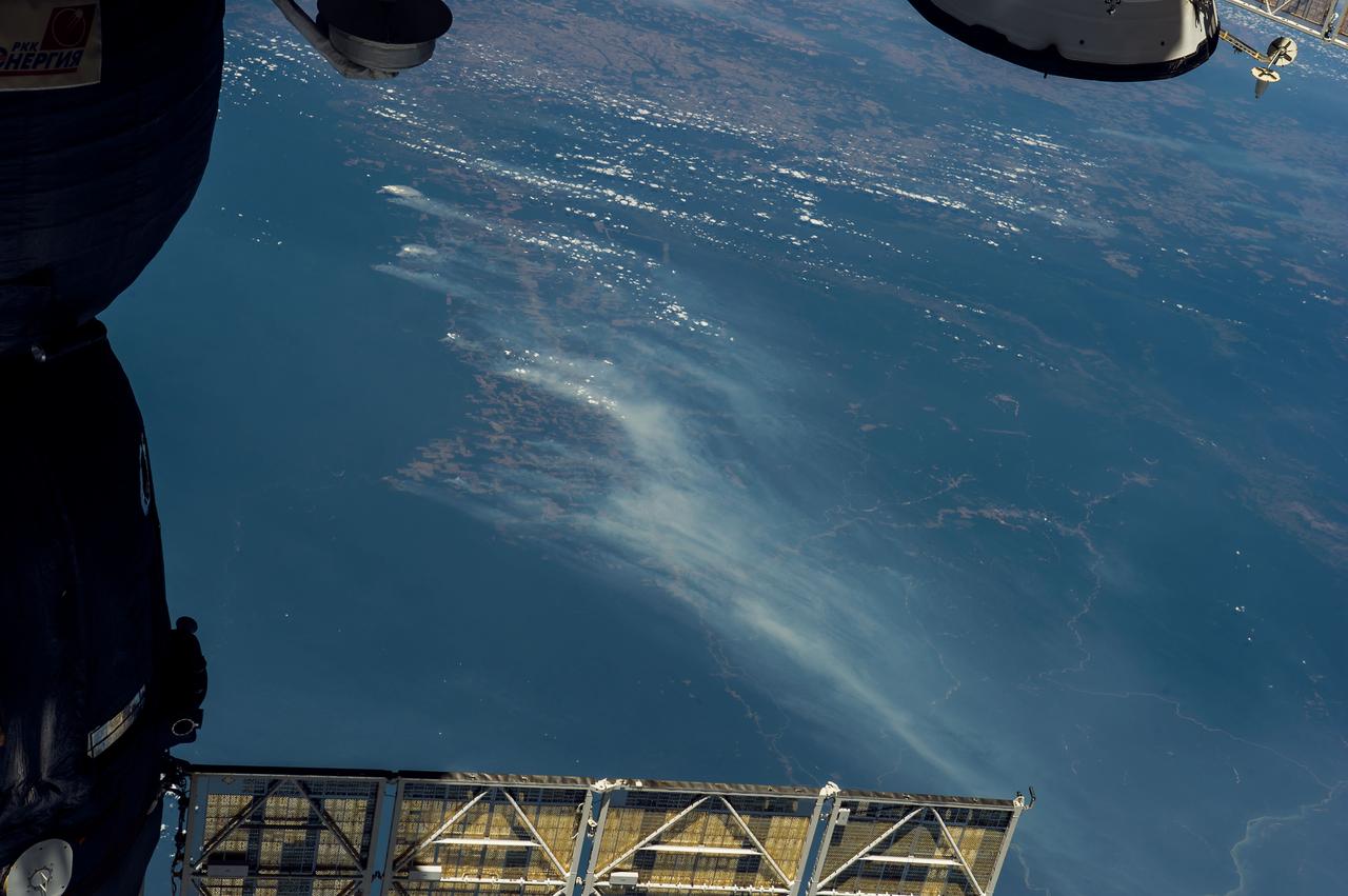
ISS028-E-010044 (27 June 2011) --- A crew member aboard the International Space Station, flying at an altitude of approximately 235 statute miles on June 27, 2011, exposed this still photograph of a major fire in the Jemez Mountains of the Santa Fe National Forest in north-central New Mexico. The fire is just southwest of Los Alamos National Laboratories.
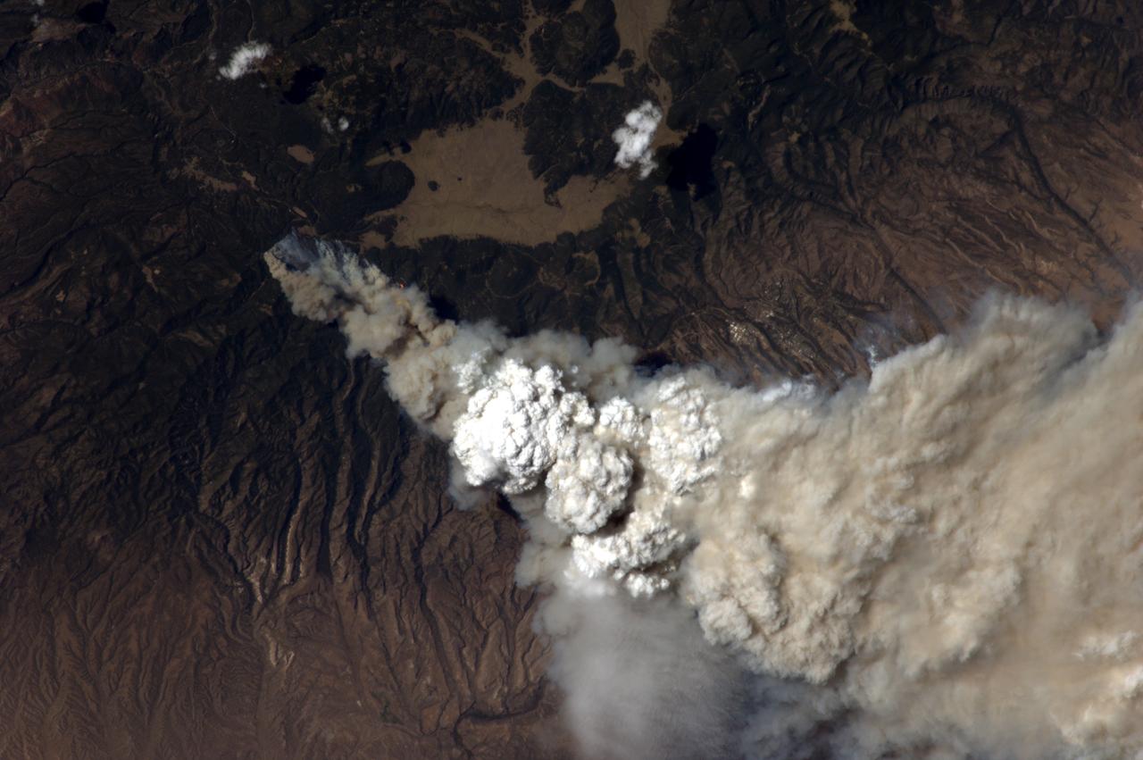
ISS028-E-010043 (27 June 2011) --- A crew member aboard the International Space Station, flying at an altitude of approximately 235 statute miles on June 27, 2011, exposed this still photograph of a major fire in the Jemez Mountains of the Santa Fe National Forest in north-central New Mexico. The fire is just southwest of Los Alamos National Laboratories, which can be seen just right of center.
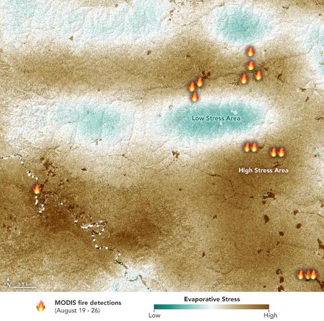
NASA's ECOsystem Spaceborne Thermal Radiometer Experiment on Space Station (ECOSTRESS) sensor measured the water-stress levels of plants when it passed over the Peruvian Amazon rainforest on Aug. 7, 2019, before the fires there began. The map shows areas of plants in distress (brown) and areas of less stress (blue). Water-stressed plants released measurably less water vapor into the air at the time of the summer fires. The fire icons represent fires imaged by NASA's Terra satellite between Aug. 19 and 26. The burn pattern reveals that the fires were concentrated in areas of highly water-stressed plants, pointing to how water-stressed plants can impact the spread of fires. The data may one day help NASA's Earth-observing missions predict the path of future forest or brush fires. https://photojournal.jpl.nasa.gov/catalog/PIA23432
The Hayman forest fire, started on June 8, is continuing to burn in the Pike National Forest, 57 km (35 miles) south-southwest of Denver. According to the U.S. Forest Service, the fire has consumed more than 90,000 acres and has become Colorado's worst fire ever. In this ASTER image, acquired Sunday, June 16, 2002 at 10:30 am MST, the dark blue area is burned vegetation and the green areas are healthy vegetation. Red areas are active fires, and the blue cloud at the top center is smoke. Meteorological clouds are white. The image covers an area of 32.2 x 35.2 km (20.0 x 21.8 miles), and displays ASTER bands 8-3-2 in red, green and blue. http://photojournal.jpl.nasa.gov/catalog/PIA03499
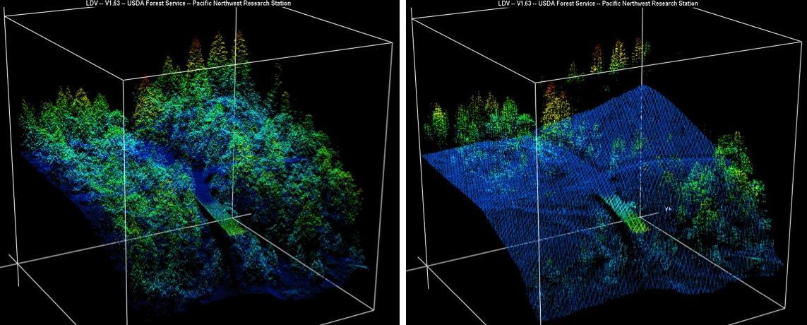
New maps of two recent California megafires that combine unique data sets from the U.S. Forest Service and NASA's Jet Propulsion Laboratory in Pasadena, California, are answering some of the urgent questions that follow a huge wildfire. These before-and-after USFS LIght Detection And Ranging (LIDAR) images from the 2014 King fire region in El Dorado National Forest, California are among new maps. They show a small section of the Rubicon River drainage basin, where fire damage was severe. Blue indicates ground level; lighter colors are higher. A road -- bordered by dense trees in the before image at left -- and part of a bridge are in the center, with the bridge appearing green. http://photojournal.jpl.nasa.gov/catalog/PIA19360
This image, acquired by NASA Terra spacecraft, is of the Pole Creek fire southwest of Sisters, Ore., which had grown to 24,000 acres as of Sept. 20, 2012. No structures have been destroyed, and the fire is mostly confined to the national forest.
During the 2003 fire season, blazes in the taiga forests of Eastern Siberia were part of a vast network of fires across Siberia and the Russian Far East, northeast China and northern Mongolia seen here by NASA Terra spacecraft.
On August 7, 2007, the Zaca fire continued to burn in the Los Padres National Forest near Santa Barbara, California. This image is from NASA Terra spacecraft.
A destructive forest fire broke out June 24, 2007 near South Lake Tahoe, Calif. This image was acquired by NASA Terra on June 27, 2007.
NASA Terra spacecraft captured this thermal infrared view of the spread of the forest fire in Valle Nuevo National Park near Costanza, Dominican Republic.
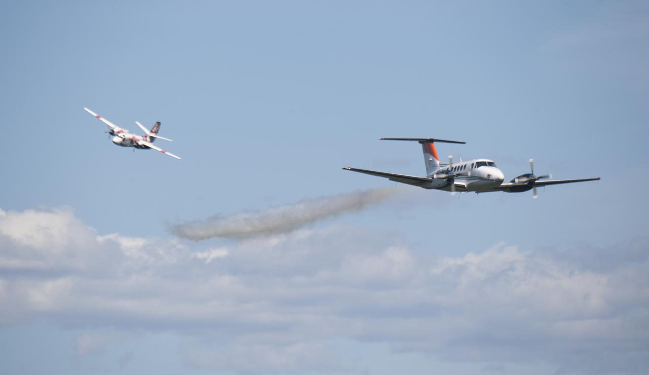
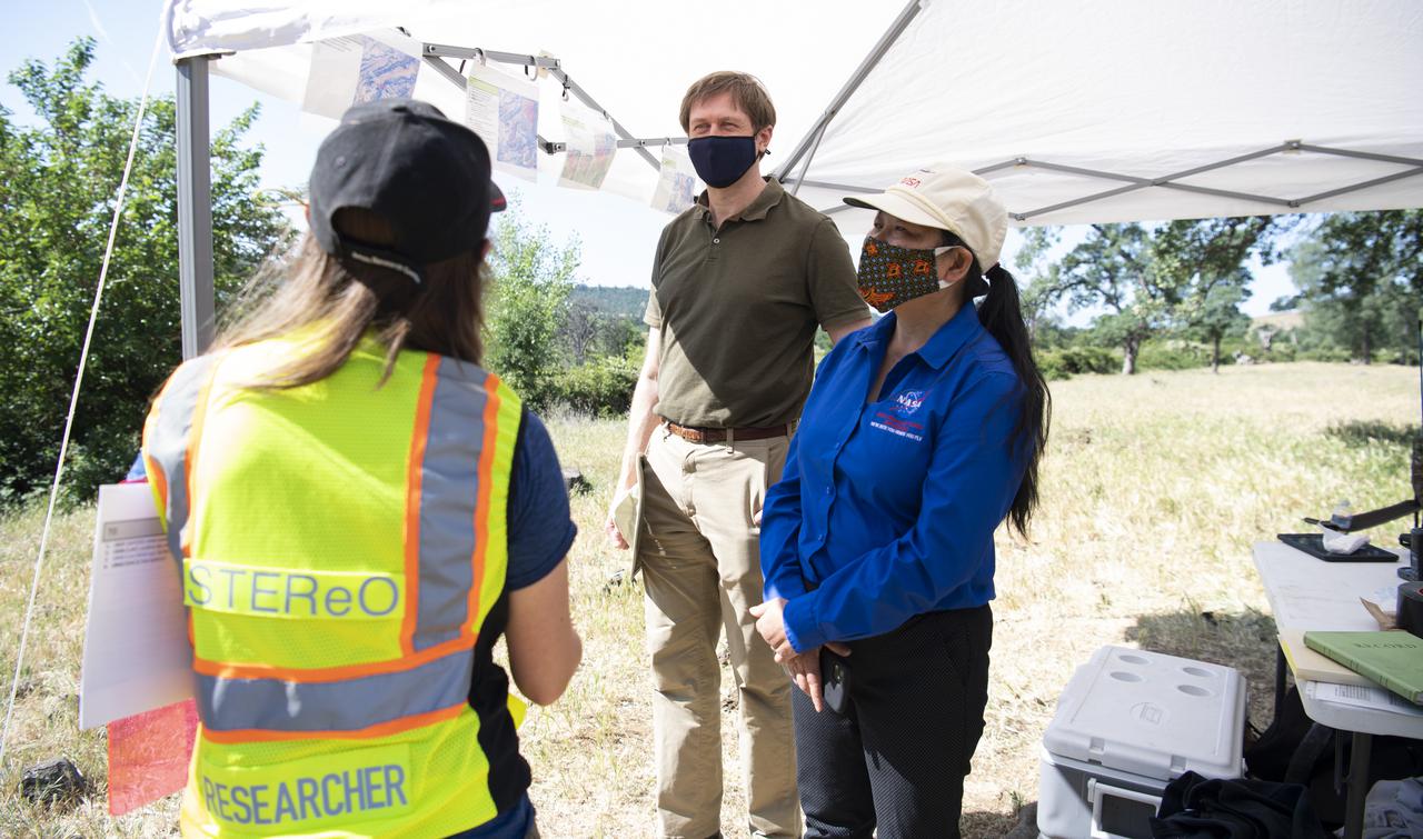
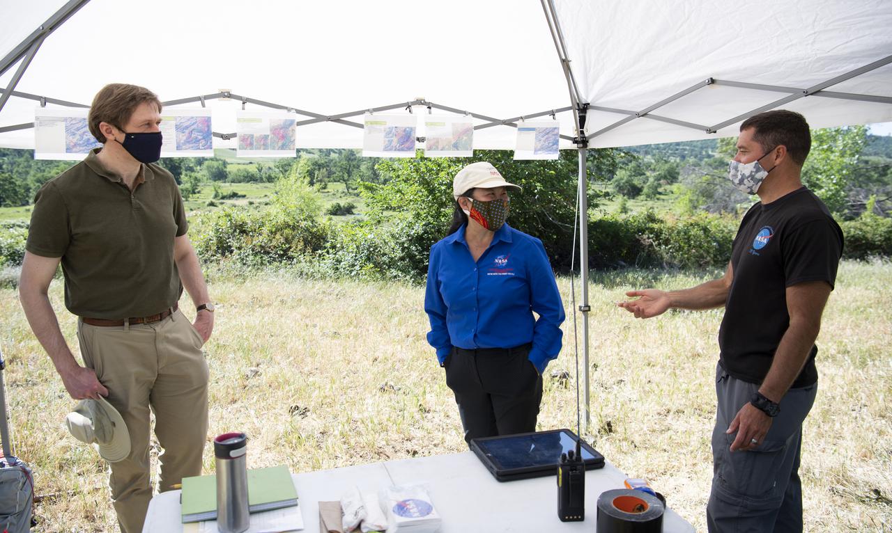
A Cal Fire S2-T airtanker follows a U.S. Forest Service King Air 200 during an aerial attack on a simulated wildfire, Tuesday, May 4, 2021 as Cal Fire conducts aerial fire fighting training exercises near Redding, California. STEReO, the Scalable Traffic Management for Emergency Response Operations project, led by NASA’s Ames Research Center, builds on NASA’s expertise in air traffic management, human factors research, and autonomous technology development to apply the agency’s work in Unmanned Aircraft Systems Traffic Management, or UTM, to public safety uses. Photo Credit: (NASA/Joel Kowsky)
NASA Terra spacecraft passed over the Silver Fire in western New Mexico on June 7, 2013. It has since consumed more than 137,000 acres of timber in a rugged area of the Gila National Forest that has not seen large fires for nearly a century.
More than 2 million acres were consumed by hundreds of fires between December 2002 and February 2003 in southeastern Australia national parks, forests, foothills and city suburbs as seen by NASA Terra spacecraft.
NASA Terra spacecraft acquired this image of the region north of Lake Baikal on Aug. 22, 2015. For weeks, forest fires have been raging in Siberia around Russia Lake Baikal.
A look at smoke from the Chisholm forest fire, which ignited on May 23, 2001 about 160 kilometers north of Edmonton in Alberta, Canada, as seen by NASA Terra spacecraft.
The worst forest fires in nearly two decades are burning out of control on Borneo, creating the thick blanket of smoke in this Oct. 14, 2015 image from NASA Terra spacecraft.
Earth observation taken during a day pass by the Expedition 36 crew. Per Twitter message: Forest fires in Portugal.
This image from NASA Terra spacecraft was acquired on Dec. 9, 2010 and shows Israel Carmel region near the city of Haifa where a deadly forest fire raged from Dec.3 to Dec.6, 2010; the burned areas appear in dark gray.
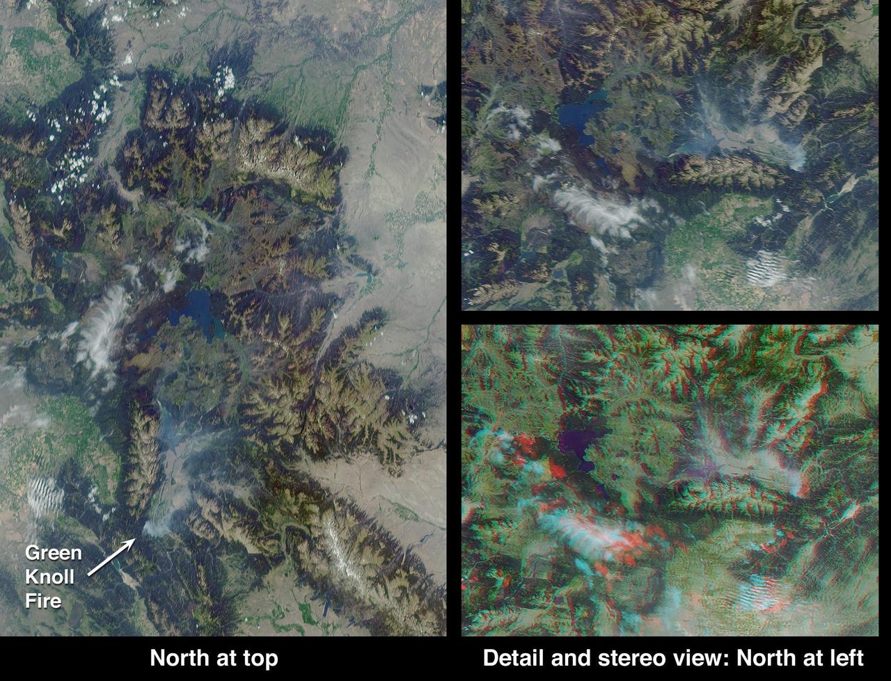
This anaglyph from the MISR instrument aboard NASA Terra spacecraft shows the area around Jackson Hole, Wyoming, where the Green Knoll forest fire raged for many days in July, 2001. 3D glasses are necessary to view this image.
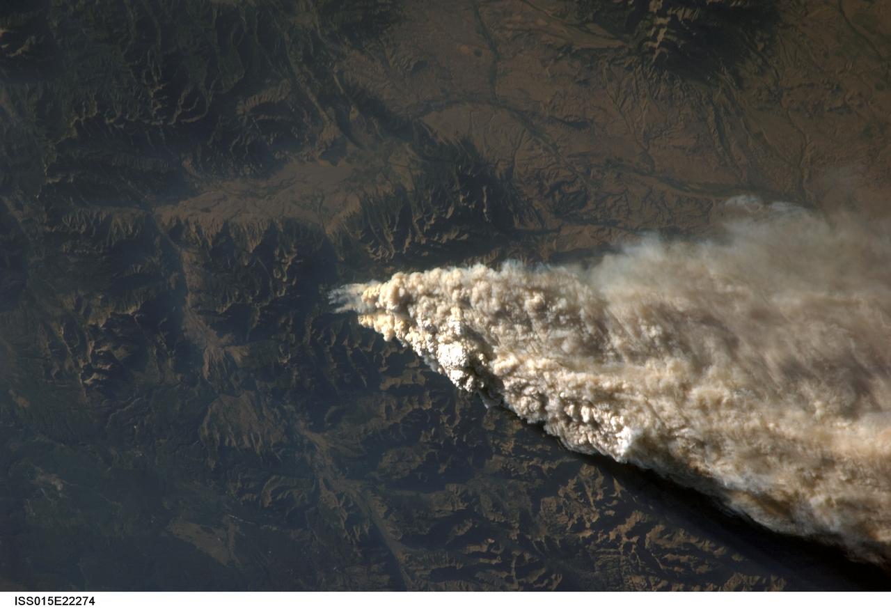
ISS015-E-22274 (13 Aug. 2007) --- Smoke plumes from a forest fire in the Gallatin National Forest, Montana is featured in this image photographed by an Expedition 15 crewmember on the International Space Station while Space Shuttle Endeavour (STS-118) was docked with the station.
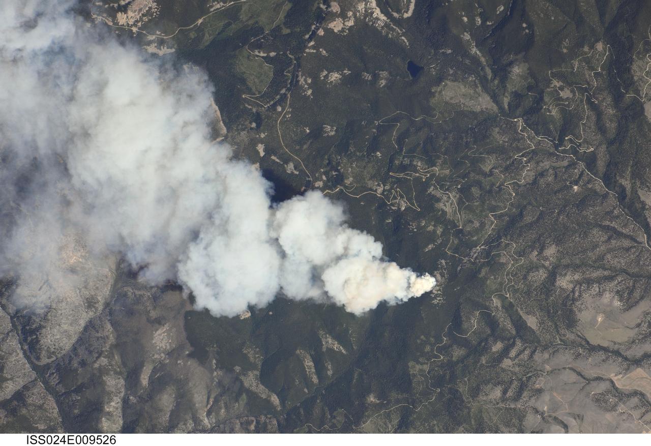
ISS024-E-009526 (25 July 2010) --- Dominic Point Fire in Montana is featured in this image photographed by an Expedition 24 crew member on the International Space Station. Lightning strikes in the forested mountains of the western United States, and human activities, can spark wild fires during the summer dry season. The Dominic Point Fire was first reported near 3:00 p.m. local time on July 25 2010. Approximately one hour later, the space station crew photographed the fire?s large smoke plume ? already extending at least eight kilometers to the east ? from orbit as they passed almost directly overhead. Forest Service fire crews, slurry bombers and helicopters were on the scene by that evening. The fire may have been started by a lightning strike, as there are no trails leading into the fire area located approximately 22 kilometers northeast of Hamilton, MT (according to local reports). As of July 26, 2010 the fire had burned approximately 283?405 hectares of the Bitterroot National Forest in western Montana. The fire is thought to have expanded quickly due to high temperatures, low humidity, and favorable winds with an abundance of deadfall ? dead trees and logs that provide readily combustible fuels ? in the area.
STS111-367-014 (5-19 June 2002) --- This view featuring Canadian forest fires was photographed by the STS-111 crewmembers aboard the Space Shuttle Endeavour. It represents an oblique view northward of one of the numerous fires observed and reported burning in the dry boreal forests of Saskatchewan and Manitoba during the month of June. The location of this one is roughly between Candle Lake, Saskatchewan and Lake Winnepegosis, Manitoba. The Gateway to Astronaut Photography of Earth (link to http://eol.jsc.nasa.gov/sseop/) provides searchable access to other photographs of Earth taken by astronauts.
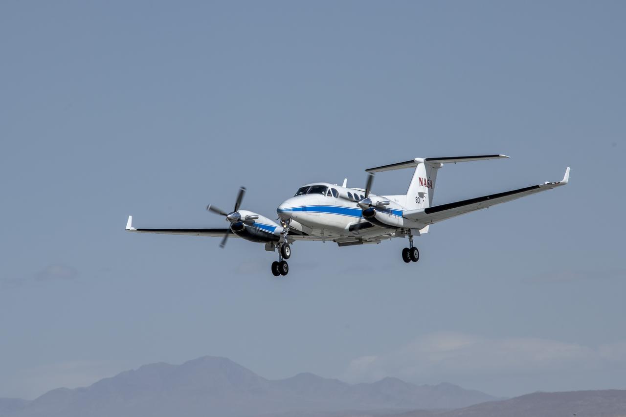
NASA’s B200 King Air aircraft – based at NASA’s Armstrong Flight Research Center in Edwards, California – ascends to support a prescribed burn in Geneva State Forest, about 100 miles south of Montgomery, Alabama, on March 17, 2025. The effort is part of NASA’s multi-year FireSense project, which aims to test technology that predicts fire and smoke behavior. This data could eventually benefit the U.S. Forest Service as well as local, state, and other federal wildland fire agencies.

NASA’s B200 King Air aircraft – based at NASA’s Armstrong Flight Research Center in Edwards, California – ascends to support a prescribed burn in Geneva State Forest, about 100 miles south of Montgomery, Alabama, on March 17, 2025. The effort is part of NASA’s multi-year FireSense project, which aims to test technology that predicts fire and smoke behavior. This data could eventually benefit the U.S. Forest Service as well as local, state, and other federal wildland fire agencies.
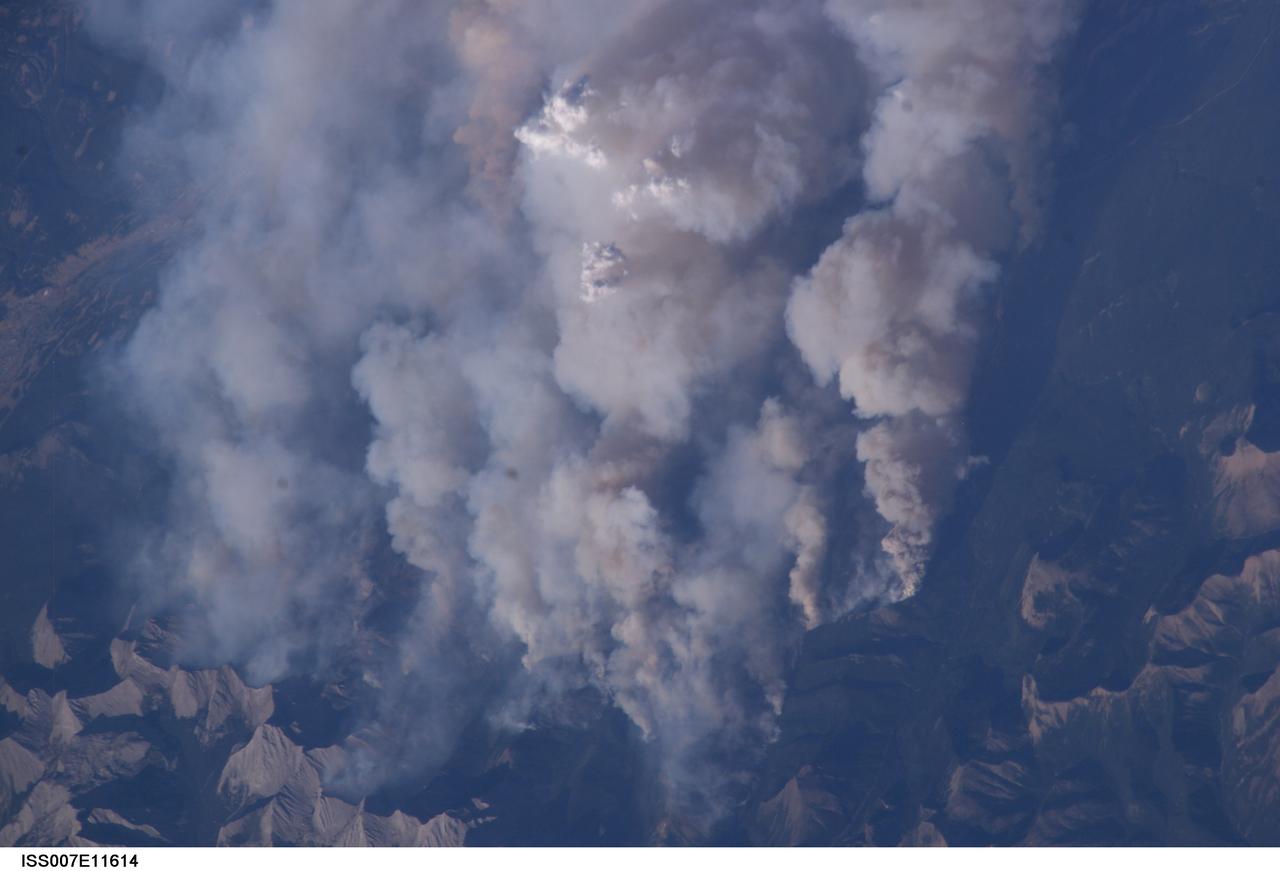
ISS007-E-11614 (2 August 2003) --- This digital still camera's view from the International Space Station features early August forest fires in the Lost Creek area on the border of Alberta and British Columbia, just to the southwest of Calgary. Across the international border, fires were raging in the Glacier National Park in Montana
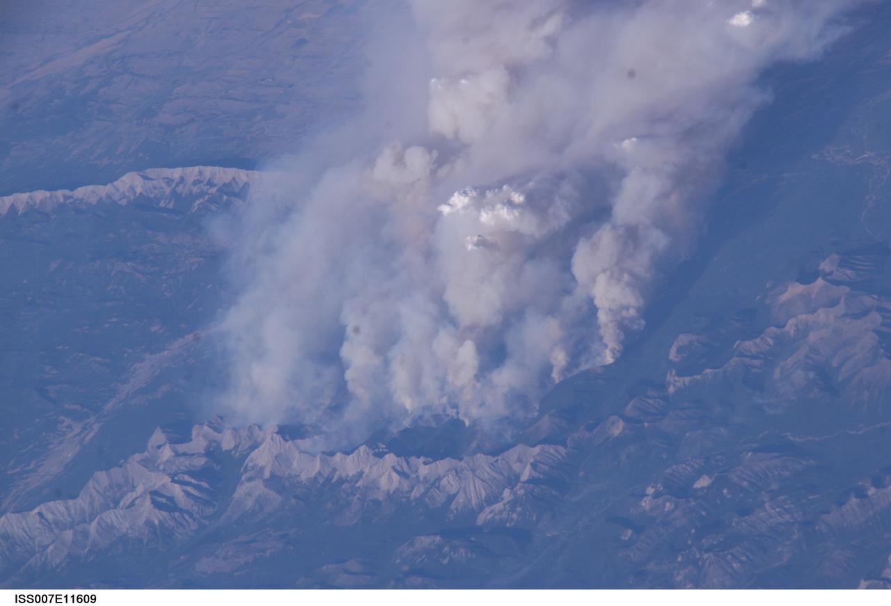
ISS007-E-11609 (2 August 2003) --- This digital still camera's view from the International Space Station features early August forest fires in the Lost Creek area on the border of Alberta and British Columbia, just to the southwest of Calgary. Across the international border, the fires were raging in the Glacier National Park in Montana
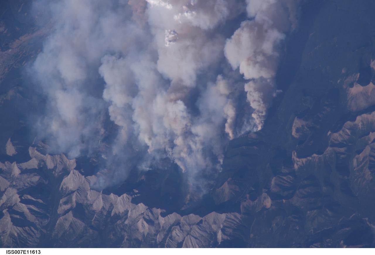
ISS007-E-11613 (2 August 2003) --- This digital still camera's view from the International Space Station features early August forest fires in the Lost Creek area on the border of Alberta and British Columbia, just to the southwest of Calgary. Across the international border, fires were raging in the Glacier National Park in Montana
This satellite image shows smoke from several fires in Oregon and California on Aug. 2, 2015. The Moderate Resolution Imaging Spectroradiometer (MODIS) instrument that flies aboard NASA's Aqua satellite captured an image of smoke from these fires Aug. 2 at 21:05 UTC (5:05 p.m. EDT). The multiple red pixels are heat signatures detected by MODIS. The smoke appears to be a light brown color. InciWeb is an interagency all-risk incident information management system that coordinates with federal, state and local agencies to manage wildfires. In Oregon smoke from the Cable Crossing Fire, the Stouts Fire and the Potter Mountain Complex Fire commingle. The Cable Crossing Fire was reported burning on forestlands protected by the Douglas Forest Protective Association (DFPA) at approximately 3:25 p.m. on Tuesday, July 28, 2015, near Oregon Highway 138 East, near Mile Post 23, east of Glide. South of the Cable Crossing Fire is the Stouts Fire also in forestlands of the DFPA. This fire was reported on Thursday, July 30, 2015, burning approximately 11 miles east of Canyonville near the community of Milo. East of the other fires is the Potter Mountain Complex Fire. These fires are located in the Deschutes Forest consists of eight fires. According to Inciweb they were started by dry lightning on Saturday, Aug. 2, at approximately 5:30 p.m. about five miles north of Toketee Lake. In northern California, smoke from the River Complex Fire, the Fork Complex Fire and the Shf July Lightning Fire was visible in the MODIS image. The River Complex currently consists of seven reported and observed fires on the Six Rivers and Shasta Trinity National Forests. Originally identified as 18 fires, some have burned together. Inciweb noted that in the Six Rivers National Forest there are fires in the Trinity Alps Wilderness. Those fires include the Groves Fire and the Elk Fire. In the Shasta-Trinity National Forest the fires include the Happy Fire at 2,256 acres, Daily Fire at 16 acres, the Look Fire at 7 acres, Onion Fire at 136 acres and Smokey Fire at 1 acre. In the same forest, south of the River Complex is the Fork Complex fire. Inciweb reported that the Fork Complex consists of (at current count) over 40 fires, all of which were ignited by lightning between July 29 and 31, 2015. To the southwest of this complex is the Mad River Complex. This is a series of seven lightning fires that started on July 30, 2015 after a lightning storm moved through Northern California. To the east of this and the other fires, burns another near Redding, California, called the Shf July Lightning Fire. This is also under the Shasta-Trinity National Forest management. At 8 p.m. PDT on Aug. 2, Inciweb reported that approximately 15 lightning strikes occurred within 24 hours throughout the Shasta Trinity National Forest and resulted in two new fires. The Caves fire, east of Mt. Shasta, is approximately one-tenth of an acre. The Bluejay fire, east of Shasta Lake, is approximately four acres. Image credit: NASA Goddard's MODIS Rapid Response Team, Jeff Schmaltz <b><a href="http://www.nasa.gov/audience/formedia/features/MP_Photo_Guidelines.html" rel="nofollow">NASA image use policy.</a></b> <b><a href="http://www.nasa.gov/centers/goddard/home/index.html" rel="nofollow">NASA Goddard Space Flight Center</a></b> enables NASA’s mission through four scientific endeavors: Earth Science, Heliophysics, Solar System Exploration, and Astrophysics. Goddard plays a leading role in NASA’s accomplishments by contributing compelling scientific knowledge to advance the Agency’s mission. <b>Follow us on <a href="http://twitter.com/NASAGoddardPix" rel="nofollow">Twitter</a></b> <b>Like us on <a href="http://www.facebook.com/pages/Greenbelt-MD/NASA-Goddard/395013845897?ref=tsd" rel="nofollow">Facebook</a></b> <b>Find us on <a href="http://instagrid.me/nasagoddard/?vm=grid" rel="nofollow">Instagram</a></b>

ISS007-E-12749 (14 August 2003) --- This view of forest fires in lower British Columbia, Canada was taken by one of the Expedition 7 crewmembers onboard the International Space Station (ISS).
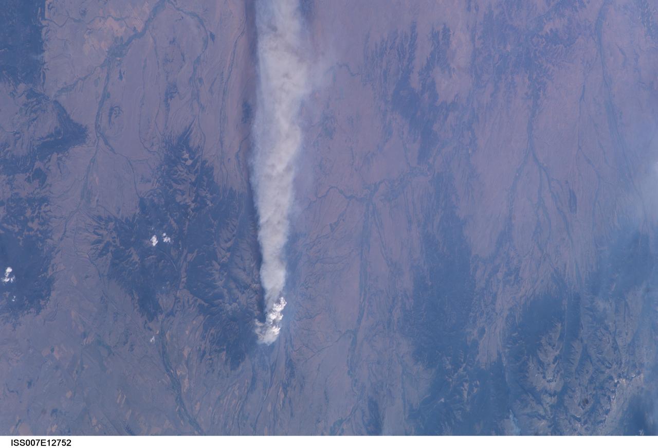
ISS007-E-12752 (14 August 2003) --- This view of forest fires in Glacier National Park in Montana was taken by one of the Expedition 7 crewmembers onboard the International Space Station (ISS).
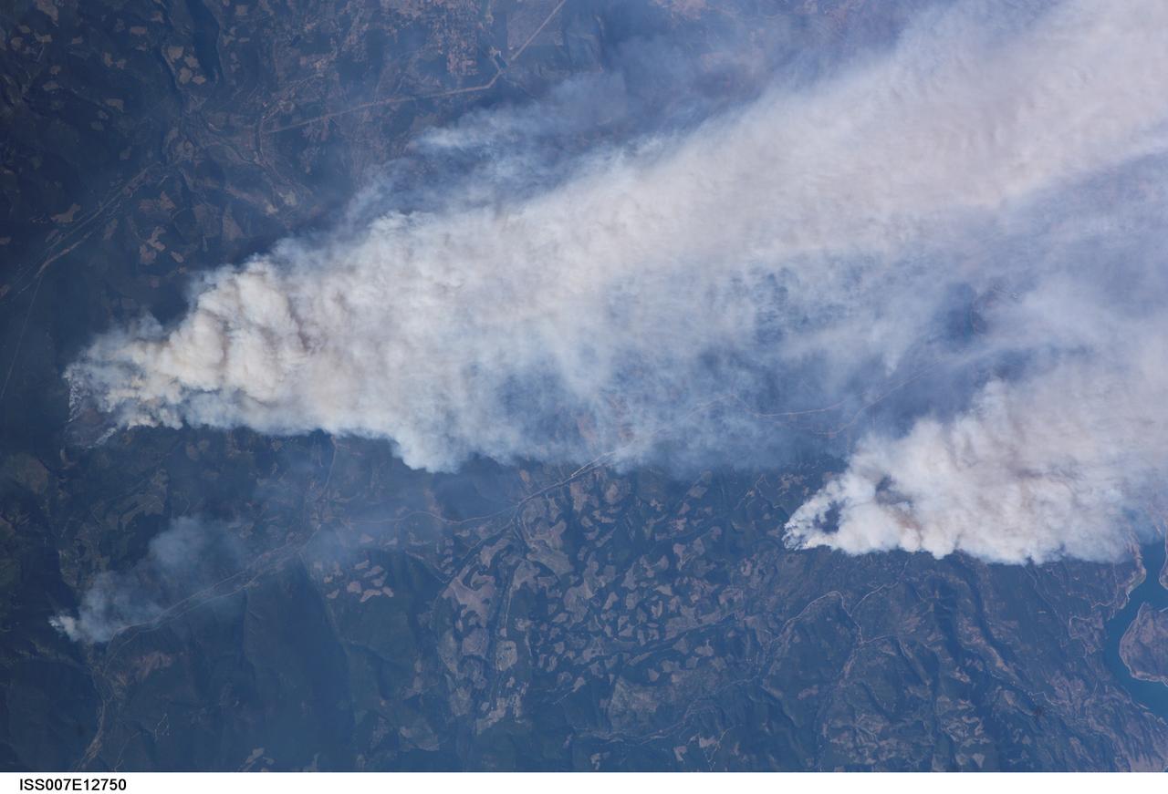
ISS007-E-12750 (14 August 2003) --- This view of forest fires in lower British Columbia, Canada was taken by one of the Expedition 7 crewmembers onboard the International Space Station (ISS).
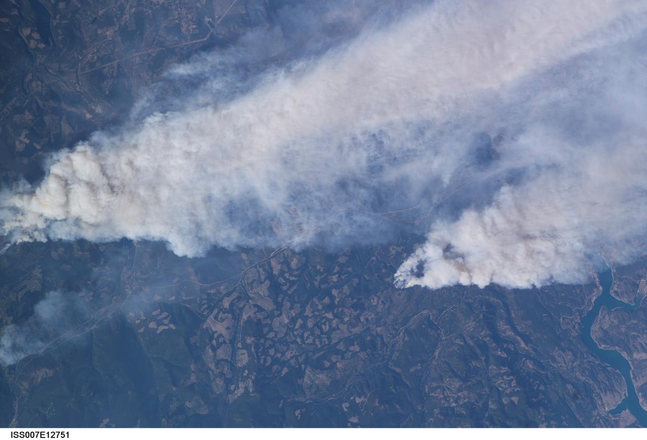
ISS007-E-12751 (14 August 2003) --- This view of forest fires in lower British Columbia, Canada was taken by one of the Expedition 7 crewmembers onboard the International Space Station (ISS).
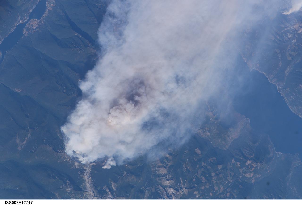
ISS007-E-12747 (14 August 2003) --- This view of forest fires in lower British Columbia, Canada was taken by one of the Expedition 7 crewmembers onboard the International Space Station (ISS).
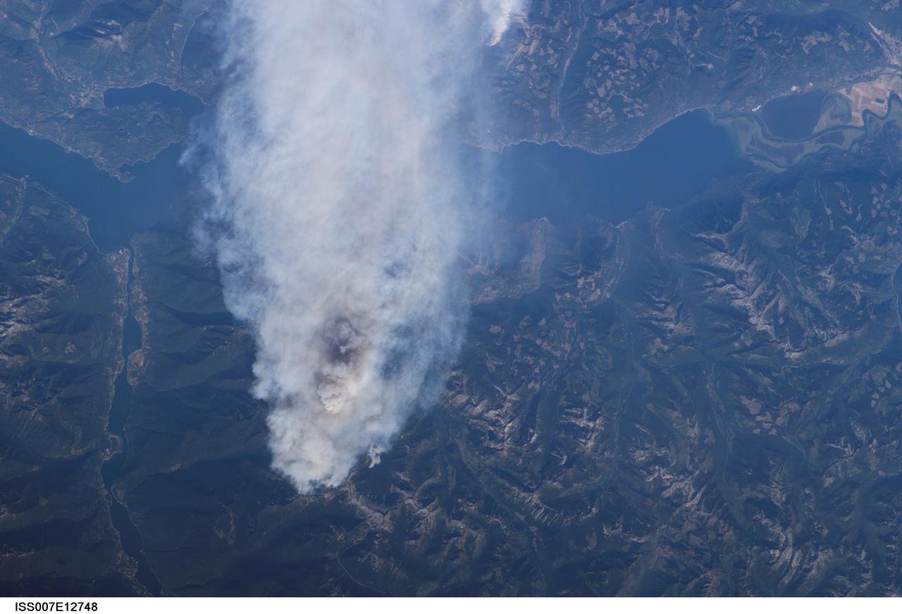
ISS007-E-12748 (14 August 2003) --- This view of forest fires in lower British Columbia, Canada was taken by one of the Expedition 7 crewmembers onboard the International Space Station (ISS).
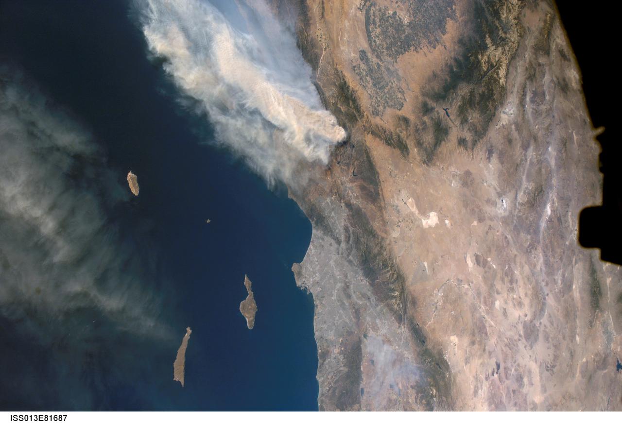
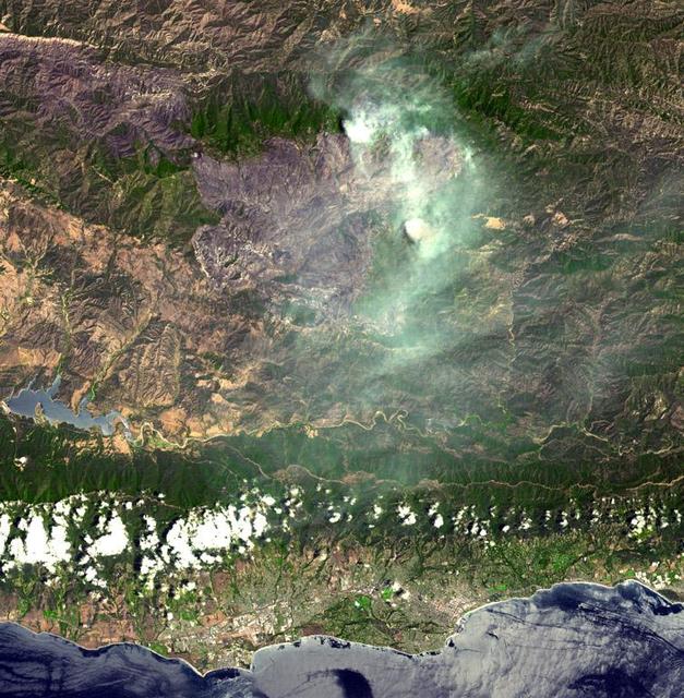
ISS013-E-81687 (17 Sept. 2006) --- A forest fire in southern California is featured in this image photographed by an Expedition 13 crewmember on the International Space Station. The day fire started in Los Padres National Forest north of Los Angeles on Sept. 4, 2006. Easterly winds on Sept. 17 blew the smoke west out to sea, and this wind shift was observed by station crewmembers. The forested mountains north of Los Angeles appear dark green, the smoke a dusky gray. Dense farmland at the south end of California's central valley is framed by the forested Sierra Nevada mountain range. White patches near the center of the view are dry lakes of the Mojave Desert, one of which acts as a landing site for the space shuttle. The dark irregular shape at image right is part of the space station. Death Valley and Las Vegas are visible at image right. The extent of the day fire smoke plume can be gauged from the gray urban region of greater Los Angeles (center) which stretches along 50 miles of coastline. The plume obscures the northern Channel Islands, but the southern Channel Islands are silhouetted against the ocean.
SL2-81-157 (22 June 1973) --- This view of the Black Hills Region, SD (44.0N, 104.0W) shows the scenic Black Hills where Mt. Rushmore and other monuments are located. Cities and towns in this view include: Rapid City, Deadwood, and Belle Fourche with the nearby Belle Fourche Reservoir. Notable in this scene are the recovering burn scars (seen as irregular shaped light toned patches) from a 1959 forest fire in the Black Hills National Forest near the edge of the photo. Photo credit: NASA
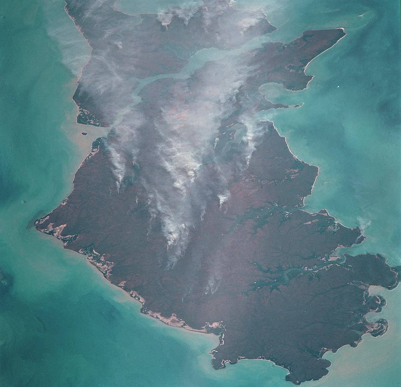
STS068-253-045 (30 September-11 October 1994) --- Forest fires in southeastern Queensland, Australia. The smoke is blowing to the east. This is the southeastern edge of the Darling Downs, a wheat-growing and sheep pasture region just west of the Great Dividing Range, southwest of Brisbane. An extensive summer drought made the forests of the range highly susceptible to wildfire.
ISS015-E-22269 (13 Aug. 2007) --- The crew aboard the International Space Station provided this image of the wide-spread forest fires in the Payette National Forest, Central Idaho within the Salmon River Mountains. North is toward the left of the image. The Salmon River is the feature in the bottom central part of the frame. Lake Cascade is seen at the lower right.
This satellite image, taken by NASA's Earth-observing Terra satellite on Aug. 18, 2019, shows the ECOSTRESS study area in the Amazon Basin and smoke from active fires in the rainforest. ECOSTRESS also captured an image of the Amazon rainforest, PIA23432, revealing water-stressed and non-stressed forest in the area. The water-stressed areas of the forest look as green and healthy as these cooler areas, making them invisible except to a radiometer that can measure thermal infrared energy from the surface. https://photojournal.jpl.nasa.gov/catalog/PIA23546
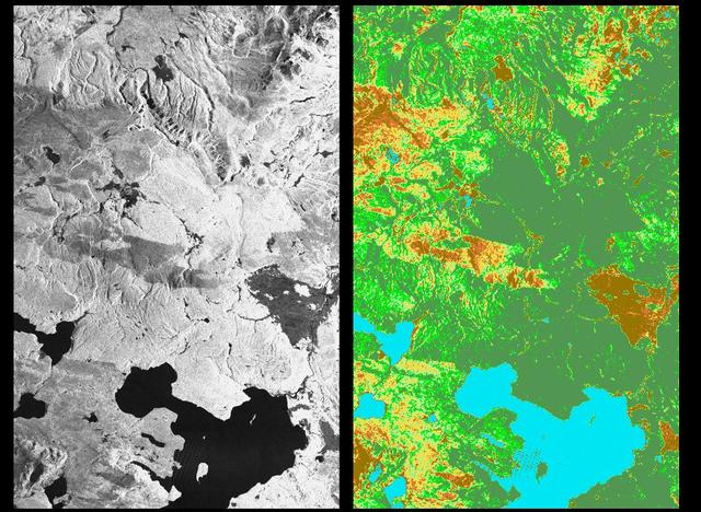
These two radar images show the majestic Yellowstone National Park, Wyoming, the oldest national park in the United States and home to the world's most spectacular geysers and hot springs. The region supports large populations of grizzly bears, elk and bison. In 1988, the park was burned by one of the most widespread fires to occur in the northern Rocky Mountains in the last 50 years. Surveys indicated that 793,880 acres of land burned. Of that, 41 percent was burned forest, with tree canopies totally consumed by the fire; 35 percent was a combination of unburned, scorched and blackened trees; 13 percent was surface burn under an unburned canopy; 6 percent was non-forest burn; and 5 percent was undifferentiated burn. Six years later, the burned areas are still clearly visible in these false-color radar images obtained by the Spaceborne Imaging Radar-C/X-band Synthetic Aperture Radar on board the space shuttle Endeavour. The image at the left was obtained using the L-band radar channel, horizontally received and vertically transmitted, on the shuttle's 39th orbit on October 2, 1994. The area shown is 45 kilometers by 71 kilometers (28 miles by 44 miles) in size and centered at 44.6 degrees north latitude, 110.7 degrees west longitude. North is toward the top of the image (to the right). Most trees in this area are lodge pole pines at different stages of fire succession. Yellowstone Lake appears as a large dark feature at the bottom of the scene. At right is a map of the forest crown, showing its biomass, or amount of vegetation, which includes foliage and branches. The map was created by inverting SIR-C data and using in situ estimates of crown biomass gathered by the Yellowstone National Biological Survey. The map is displayed on a color scale from blue (rivers and lakes with no biomass) to brown (non-forest areas with crown biomass of less than 4 tons per hectare) to light brown (areas of canopy burn with biomass of between 4 and 12 tons per hectare). Yellow indicates areas of canopy burn and mixed burn with a biomass of between 12 to 20 tons per hectare; light green is mixed burn and on-burn forest with a biomass of 20 to 35 tons per hectare; and green is non-burned forest with a biomass of greater than 35 tons per hectare. Forest recovery from the fire seems to depend on fire intensity and soil conditions. In areas of severe canopy burn and poor soil conditions, crown biomass was still low in 1994 (indicated by the brown areas at the center left), whereas in areas of mixed burn with nutrient-rich soils, seen west of Yellowstone Lake, crown biomass has increased significantly in six years (indicated by the yellow and light green areas). Imaging fire-affected regions with spaceborne radar illustrates SIR-C/X-SAR's keen abilities to monitor regrowth after a fire. Knowing the amount of carbon accumulated in the atmosphere by regenerating forest in the 20 to 50 years following a fire disturbance is also a significant factor in understanding the global carbon cycle. Measuring crown biomass is necessary to evaluate the effects of past and future fires in specific regions. http://photojournal.jpl.nasa.gov/catalog/PIA01741
ISS017-E-010310 (4 July 2008) --- The Piute fire in California is featured in this image photographed by an Expedition 17 crewmember on the International Space Station. The Piute fire, burning south of Lake Isabella in the Sequoia National Forest in the southern Sierra Nevada Mountains, is one of the more than 300 wildfires burning across the state of California. The fire started June 28 just north of Twin Oaks, California, and has burned nearly 14,000 acres so far. Current estimates by fire officials suggest the fire may not be brought under control for another two weeks.

STS039-83-059 (28 April-6 May 1991) --- This high oblique view taken from over southeastern Quebec, looking to the southwest down the estuary of the St. Lawrence River (Fleuve Saint-Laurent). The primary road on the north side of the river (right) runs from Quebec, at the end of the estuary behind Ile D'Orleans, northeast to its terminus at Sept-Iles (near nadir, and not visible in this scene). The St. Lawrence disappears underneath the cloud bank over western New York and Ontario just to the west of Montreal. The light snow cover enhances the area of forests (dark) and non-forest (white). In this view, most of the irregular areas of white on the right side of the St. Lawrence River are previously forested areas that were burned over during the extraordinary Canadian forest fires of 1989.
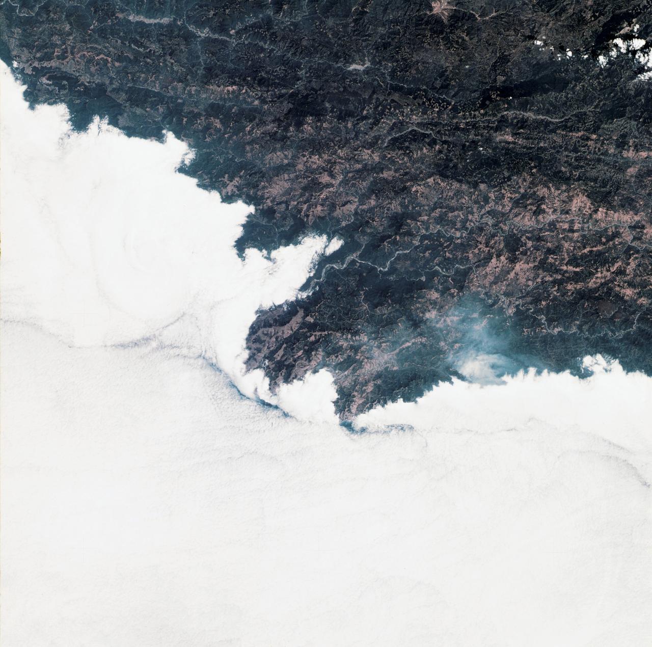
ISS029-E-008032 (17 Sept. 2011) --- Fires along the Rio Xingu, Brazil are featured in this image photographed by an Expedition 29 crew member on the International Space Station. The rain forest of South America, also known as ?Amazonia??the largest such forest on Earth?has been undergoing a continual and accelerated land use conversion process into farmlands (including pasture for livestock) since the early 1960s. This process has typically been achieved by clearing of the forest using fire ? ?slash and burn? ? followed by planting of crops. The generally infertile soils of the region make sustainable farming difficult; this drives more forest conversion into new farmland. The area of clearing can be considerable, and as the deforested regions are easily identifiable and measurable from space the rate of deforestation is likewise easy to track. This detailed photograph illustrates slash-and-burn forest clearing along the Xingu River (Rio) in the northeast of the state of Matto Grasso, Brazil. The perspective of this image allows for a striking visualization of both the horizontal position and extent of the fire lines next to the river, as well as providing a sense of the vertical structure of the smoke plumes due to the viewing angle and shadowing. Light colored areas within the river channel are sand bars, which show that the river is in its annual low-flow/ low water stage. For a sense of scale, the Xingu River channel within the view is approximately 63 kilometers long. Rivers in Amazonia are its natural highways, which may explain why the burning is occurring right next to the Xingu River, one of Amazonia?s largest. In recent years, preservation has gained traction in the region as a result of such considerations as new valuation of the ecosystem services provided by the forest, concerns about the impact of widespread burning on global climate change, and greater sensitivity to the ethnic and biological heritage of Amazonia.
SL3-34-336 (July-September 1973) --- A vertical view of a portion of northern California near the Pacific coast as photographed from Earth orbit by one of the six lenses of the Itek-furnished S190-A Multispectral Photographic Facility Experiment in the Multiple Docking Adapter of the Skylab space station. A cloud deck covers the Pacific Ocean. Most of Cape Mendocino is clear of clouds and extends into the Pacific as the westernmost part of California. The sinuous pattern of the Bel River (in center) flows northward into the ocean and is characteristic of the rivers that drain the coastal ranges. This area is immediately southeast of Eureka. During Skylab 3 extensive forest fires occurred near Briceland and the smoke rising from the fires is clearly visible next to the cloud bank. Redwood and fir forests are sources of lumber in this region; and a variety of clear cut (timbering) patterns appear as light against the dark forest. The patterns appear to be related to the topography. Analysis of this photograph will aid Dr. P.G. Langley, Earth Satellite Corporation, in developing methods for forest inventory using space photography. Federal agencies participating with NASA on the EREP project are the Departments of Agriculture, Commerce, Interior, the Environmental Protection Agency and the Corps of Engineers. All EREP photography is available to the public through the Department of Interior?s Earth Resources Observations Systems Data Center, Sioux Falls, South Dakota, 57198. Photo credit: NASA

ISS036-E-035677 (24 Aug. 2013) --- One of the Expedition 36 crew members aboard the International Space Station used a 50mm lens to record this high oblique view of the massive drought-aided Rim Fire in and around California's Yosemite National Park and the Stanislaus National Forest on Aug. 24. Editor's Note: The fire began on Aug. 17 and, as of Aug. 26, continues to burn. More than 224 square miles have been affected.
ISS036-E-037185 (26 Aug. 2013) --- One of the Expedition 36 crew members aboard the International Space Station used a 50mm lens to record this view of the massive drought-aided Rim Fire in and around California's Yosemite National Park and the Stanislaus National Forest on Aug. 26. The fire began on Aug. 17 and, at the time of this photo on Aug. 26, it still continues to burn, as some 3,700 firefighters battle it. More than 224 square miles have been affected.
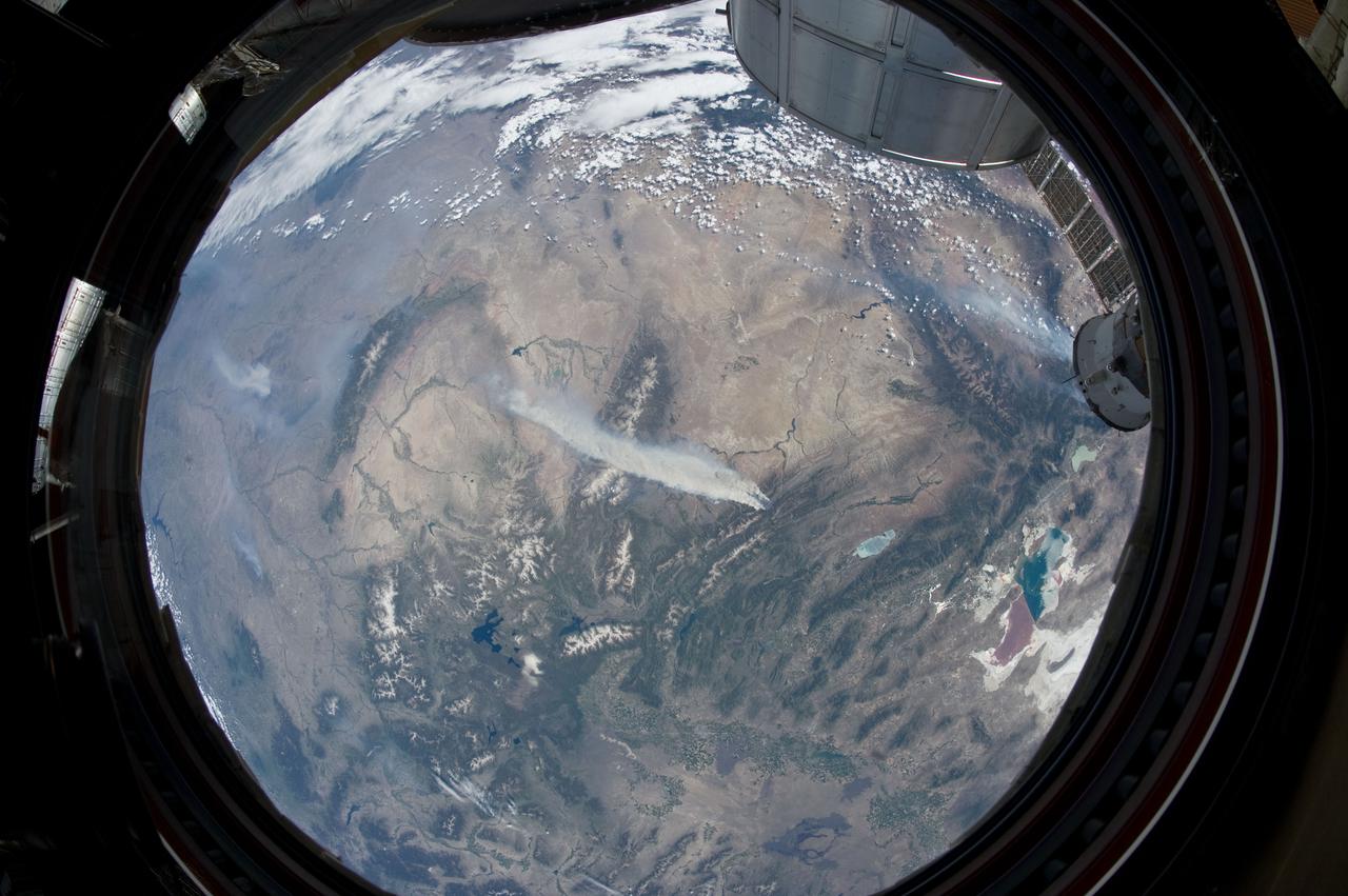
ISS031-E-146344 (27 June 2012) --- An Expedition 31 crew member aboard the International Space Station, flying approximately 240 miles above Earth, recorded a series of images of the current wild fires in the southwestern United States. For this particular image, taken from the station?s Cupola, he used a 16mm lens, which gives this view a ?fisheye? affect. The fires give rise to thick smoke plumes on the southernmost extremity of the Wyoming Range, which occupies the center of the image. Slopes of the central Salt River Range appear at left. Three helicopters and more than 100 personnel are fighting the fire, which is being managed by the Bridger?Teton National Forest.
In early August 2017, the Cinder Butte fire burned 9 miles (15 kilometers) outside of the town of Riley, Oregon, and consumed more than 82 square miles (53,000 acres) of forest and brushland. The fire threatened tribal archaeological sites with strong significance to the Burns Paiute and Klamath tribes. Firefighters were able to contain the fire before it could damage the historic sites. On the image, the burned area is gray-brown, and cloud shadows are dark gray-to-black. The image was acquired Aug. 23, 2017, covers an area of 20 by 25 miles (31.5 by 39.9 kilometers), and is located at 43.5 degrees north, 119.9 degrees west. https://photojournal.jpl.nasa.gov/catalog/PIA21879
STS062-106-042 (4-18 March 1994) --- This view of southern Australia about 100 miles northwest of Melbourne shows areas of protected reserves of natural forests in the midst of agricultural crop lands. The green patch seen here has been recently burned as indicated by the irregular large scar. The impact of winds on the scar is clearly visible. This nature preserve is reported to be the home to a large number of animals including the koala bears. Similar views were shot by the STS-60 crewmembers last month. These photographs will assist earth scientists in mapping the impact of forest fires and in moniotring the recovery of burned areas.
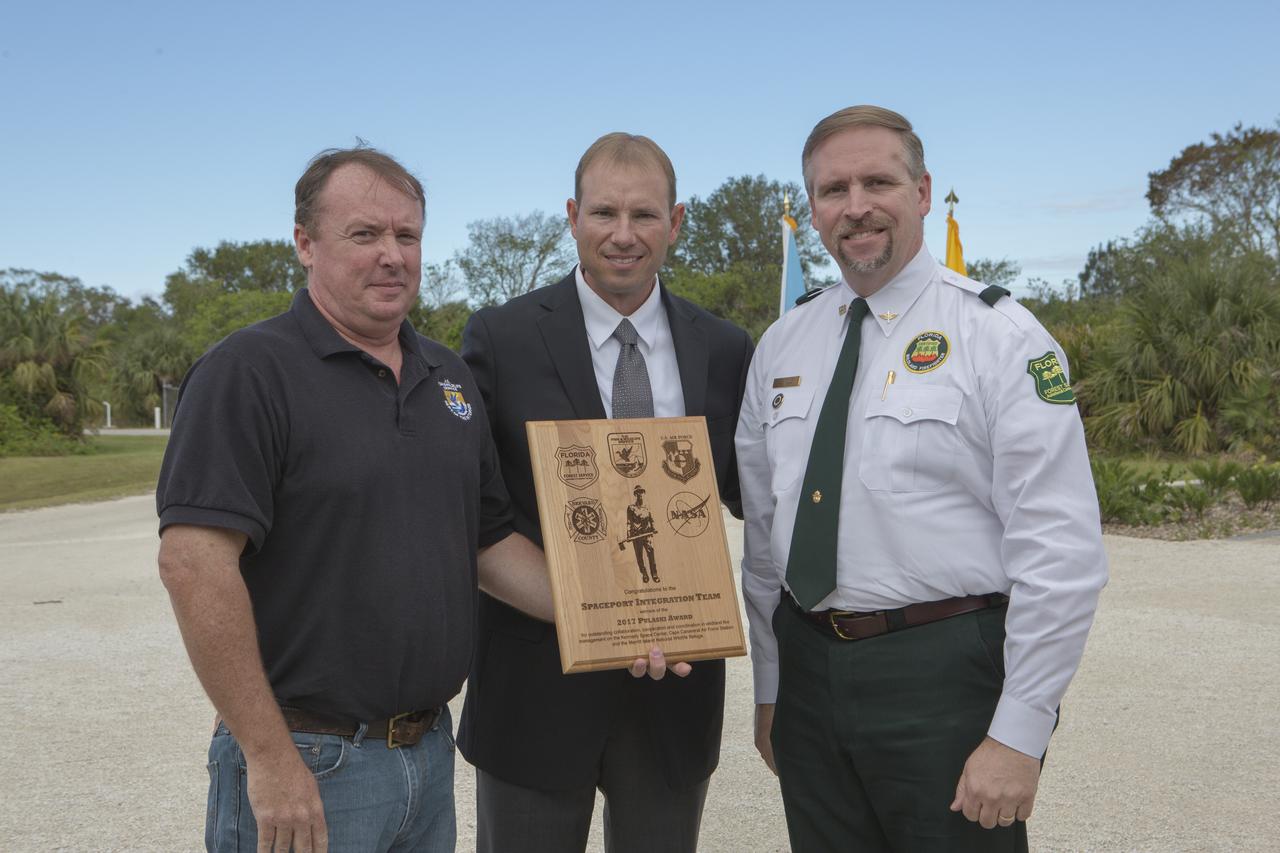
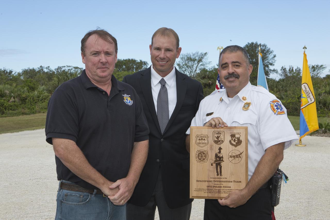
From left, Jon Wallace, deputy fire coordinator, U.S. Fish and Wildlife Service Southeast Region, Atlanta, Georgia; Chris Wilcox, U.S. Fish and Wildlife chief, Fire Management, National Interagency Fire Center, Boise, Idaho; and John Fish, chief, Florida Forest Service, pose for a portrait following a ceremony Nov. 1 on the Merritt Island National Wildlife Refuge in Florida. During the joint ceremony, the Spaceport Integration Team and its partners were presented with the prestigious 2017 Pulaski Award and a new memorial marker was dedicated. The multi-agency team includes representatives from NASA's Kennedy Space Center, Cape Canaveral Air Force Station's 45th Space Wing, the Merritt Island National Wildlife Refuge, as well as the Florida Forest Service and Brevard County Fire Rescue. The memorial marker honors two fallen firefighters, Scott Maness and Beau Sauselein, who died fighting a wildfire on space center property in 1981. Held outdoors, the ceremony was attended by 140 guests.
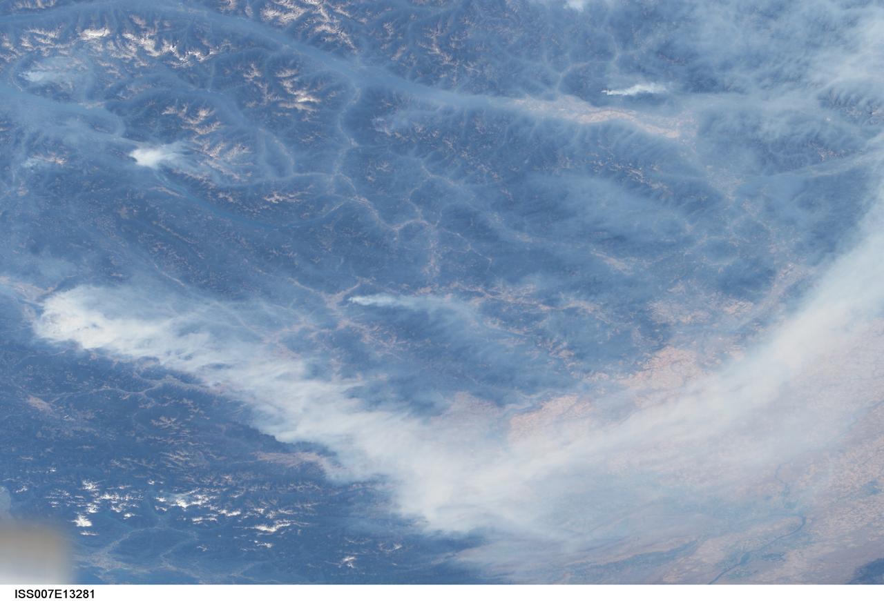
ISS007-E-13281 (20 August 2003) --- This view features forest fires in the Canadian province of British Columbia where some 620,000 acres of forest were consumed in almost 2,500 fires. Here the Rocky Mountains have both lofty, snow-capped peaks and long, narrow valleys that create special conditions and problems with air quality from these smoky fires. This image taken by one of the Expedition 7 crewmembers onboard the International Space Station (ISS) illustrates how smoke has become trapped in valleys where light winds and cold air drainage from the higher elevations have created temperature inversions. Note how the snowy peaks of the mountains are relatively smoke-free while the long, north-south valleys of Kootenay Lake and Columbia River are filled with trapped aerosols from the plumes of the large fires situated in the southwest. Meanwhile shifting winds have now swept the bulk of the plumes southeastward over the Columbia River Basin of Washington.
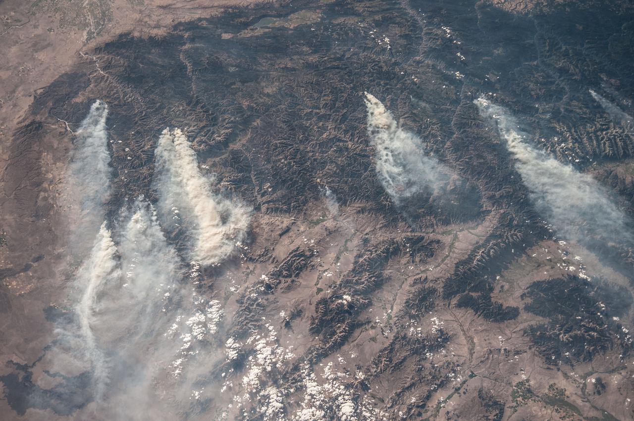
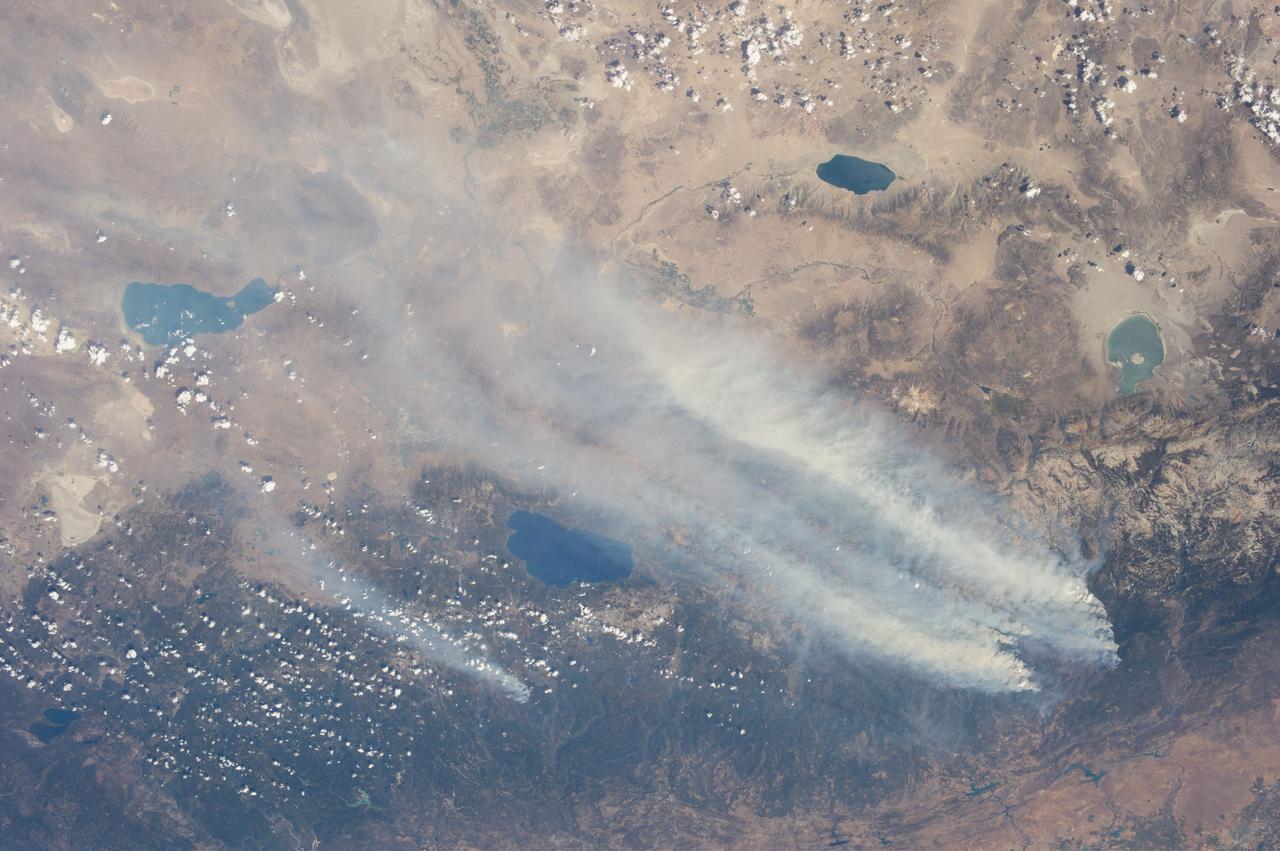
ISS036-E-032853 (18 Aug. 2013) --- Central Idaho wildfires are featured in this image photographed by an Expedition 36 crew member on the International Space Station. Taken with a short lens (50 mm), this west-looking image covers much of forested central Idaho?the dark areas are all wooded mountains. The image highlights part of the largest single wilderness area in the contiguous United States (the Frank Church-River of No Return Wilderness). Within this mountainous region, several fires can be seen producing extensive smoke plumes. Some fires had been named by Aug. 20, 2013, two days after the image was taken. The densest smoke on that day appears to be generated by a combination of the Little Queens and Leggit fires (left, within the Salmon River Mountains). The named fires were mostly set by lightning, and on Aug. 20 totaled 53,000 acres of burned forest south of the Salmon River, and many more if the unnamed fires are included. The Gold Pan fire north of the Salmon River had burned 27,000 acres. For a sense of scale in this oblique view, the Gold Pan fire lies about 125 miles north of the Little Queens fire. This image shows the common pattern of westerly winds transporting smoke in an easterly direction, as seen during the wildfire season of one year ago. Ten days before this image was taken, fires in central Idaho near Boise were aggravated by southerly winds. Some of the fires began to burn in July but were quelled and remain under observation for new flare-ups. Smoke from fires in the south partly obscures the black lava flows of the Craters of the Moon National Monument (lower left). The Beaverhead Mountains mark the eastern boundary of Idaho with Montana.
STS043-151-159 (2-11 August 1991) --- This photograph looks westward over the high plateau of the southern Peruvian Andes west and north of Lake Titicaca (not in field of view). Lima, Peru lies under the clouds just north of the clear coastal area. Because the high Andes have been uplifted 10,000 to 13,000 feet during the past 20 million years, the rivers which cut down to the Pacific Ocean have gorges almost that deep, such as the Rio Ocona at the bottom of the photograph. The eastern slopes of the Andes are heavily forested, forming the headwaters of the Amazon system. Smoke from burning in the Amazon basin fills river valleys on the right side of the photograph. A Linhof camera was used to take this view.
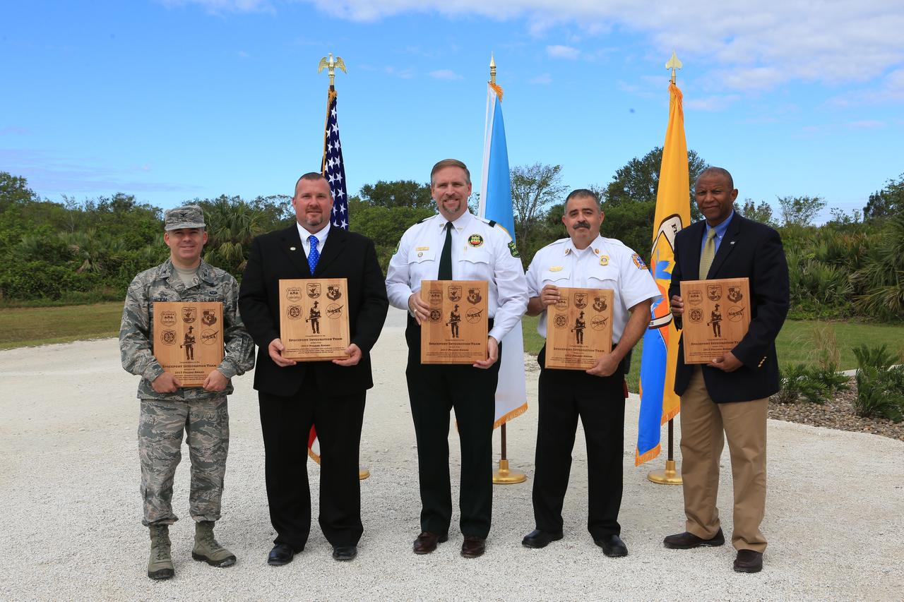
From left, Col. Z. Walter Jackim, vice commander, 45th Space Wing, Cape Canaveral Air Force Station; Michael Good, assistant fire management officer, Merritt Island National Wildlife Refuge; John Fish, chief, Florida Forest Service; Mark Schollmeyer, chief, Brevard County Fire Rescue; and Kelvin Manning, associate director, NASA's Kennedy Space Center, pose for a portrait following a ceremony Nov. 1 on the Merritt Island National Wildlife Refuge in Florida. During the joint ceremony, the Spaceport Integration Team and its partners were presented with the prestigious 2017 Pulaski Award and a new memorial marker was dedicated. The multi-agency team includes representatives from NASA's Kennedy Space Center, Cape Canaveral Air Force Station's 45th Space Wing, the Merritt Island National Wildlife Refuge, as well as the Florida Forest Service and Brevard County Fire Rescue. The memorial marker honors two fallen firefighters, Scott Maness and Beau Sauselein, who died fighting a wildfire on space center property in 1981. Held outdoors, the ceremony was attended by 140 guests.
On November 18, 2003, the Advanced Spaceborne Thermal Emission and Reflection Radiometer (ASTER) on NASA's Terra satellite acquired this image of the Old Fire/Grand Prix fire east of Los Angeles. The image is being processed by NASA's Wildfire Response Team and will be sent to the United States Department of Agriculture's Forest Service Remote Sensing Applications Center (RSAC) which provides interpretation services to Burned Area Emergency Response (BAER) teams to assist in mapping the severity of the burned areas. The image combines data from the visible and infrared wavelength regions to highlight the burned areas. http://photojournal.jpl.nasa.gov/catalog/PIA04879
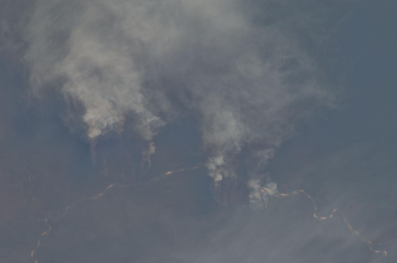
ISS012-E-13692 (2 Jan. 2006) --- A Forest Fire in Ouachita National Wildlife Refuge, Louisiana is featured in this image photographed by an Expedition 12 crew member on the International Space Station. Dry conditions and high winds have led to numerous recent fire outbreaks throughout much of the southwestern and south-central USA. This image captures the smoke plume from a fire in the Upper Ouachita National Wildlife Refuge in northeastern Louisiana. Drought conditions have persisted for much of the past year, leading to an increased fuel load comprised of dried grasses, shrubs, and trees. The combination of high amounts of dry fuel and frequent high winds has stoked small point fires into widespread brush fires. The fires generating this minimum 25-kilometer smoke plume started at approximately 13:00 hours local time. This image was acquired approximately 3.5 hours later as the station passed over the Texas/Louisiana border to the southwest. The extent of the plume reflects the strong westerly winds that drove the fire eastwards and damaged an estimated 200-300 acres of the wildlife refuge. The striking illumination of the plume is caused by a very low sun angle (angle between the horizon and the Sun directly below the space station), but this also results in generally low illumination of other scene features such as agricultural fields.
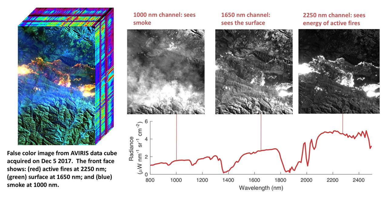
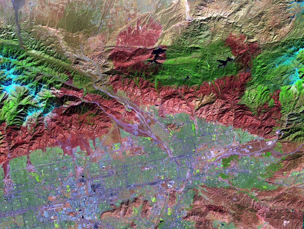
NASA's Airborne Visible Infrared Imaging Spectrometer instrument (AVIRIS), flying aboard a NASA Armstrong Flight Research Center high-altitude ER-2 aircraft, flew over the wildfires burning in Southern California on Dec. 5, 2017 and acquired this false-color image. Active fires are visible in red, ground surfaces are in green and smoke is in blue. AVIRIS is an imaging spectrometer that observes light in visible and infrared wavelengths, measuring the full spectrum of radiated energy. Unlike regular cameras with three colors, AVIRIS has 224 spectral channels from the visible through the shortwave infrared. This permits mapping of fire temperatures, fractional coverage, and surface properties, including how much fuel is available for a fire. Spectroscopy is also valuable for characterizing forest drought conditions and health to assess fire risk. AVIRIS has been observing fire-prone areas in Southern California for many years, forming a growing time series of before/after data cubes. These data are helping improve scientific understanding of fire risk and how ecosystems respond to drought and fire. https://photojournal.jpl.nasa.gov/catalog/PIA11243
ISS040-E-070424 (19 July 2014) --- One of the Expedition 40 crew members aboard the Earth-orbiting International Space Station recorded this July 19 image of wildfires which are plaguing the Northwest and causing widespread destruction. The orbital outpost was flying 223 nautical miles above Earth at the time of the photo. Lightning has been given as the cause of the Ochoco Complex fires in the Ochoco National Forest in central Oregon. The complex has gotten larger since this photo was taken.

Lit by sunlight filtered through the smoke of a distant forest fire, the Space Shuttle Atlantis receives post-flight servicing in the Mate-Demate Device (MDD), following its landing at NASA's Dryden Flight Research Center, Edwards, California. The gantry-like MDD structure is used for servicing the shuttle orbiters in preparation for their ferry flight back to the Kennedy Space Center in Florida, including mounting the shuttle atop NASA's modified Boeing 747 Shuttle Carrier Aircraft.
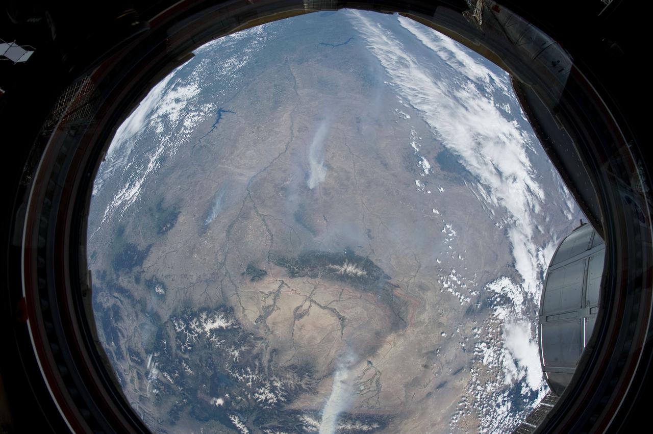
ISS031-E-146343 (27 June 2012) --- An Expedition 31 crew member aboard the International Space Station, flying approximately 240 miles above Earth, recorded a series of images of the current wild fires in the west and southwestern United States. For this particular image, taken from the station?s Cupola, he used a 16mm lens, which gives this view a ?fisheye? affect. The fires give rise to thick smoke plumes on the southernmost extremity of the Wyoming Range, which occupies the bottom left portion of the image. Three helicopters and more than 100 personnel are fighting the fire, which is being managed by the Bridger?Teton National Forest. Part of a docked Russian Soyuz spacecraft and the Multi-Purpose Logistics Module (MPLM) are at lower right.
Thirteen years after devastating forest fires burned over 1.6 million acres in Yellowstone National Park, the scars are still evident. In this simulated natural color ASTER image, burned areas appear gray, in contrast to the dark green of unburned forests. The image covers an area of 60 x 63 km. This image was acquired on July 2, 2001 by the Advanced Spaceborne Thermal Emission and Reflection Radiometer (ASTER) on NASA's Terra satellite. With its 14 spectral bands from the visible to the thermal infrared wavelength region, and its high spatial resolution of 15 to 90 meters (about 50 to 300 feet), ASTER images Earth to map and monitor the changing surface of our planet. http://photojournal.jpl.nasa.gov/catalog/PIA03875
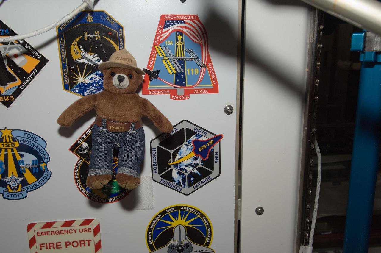
ISS032-E-011654 (3 Aug. 2012) --- Smokey Bear floats freely near crew insignias placed in the Unity node of the International Space Station. On May 15, 2012, Smokey traveled aboard the Soyuz spacecraft with NASA astronaut Joe Acaba and Russian cosmonauts Gennady Padalka and Sergei Revin to the space station. As a recognized symbol for wildland fire prevention, his presence on the orbiting complex also highlights the many areas of active space station research related to Earth observations, plant growth and combustion and materials sciences, as well as existing spinoff technologies in these areas. NASA, the U.S. Forest Service (USFS) and the Texas Forest Service are teaming up to celebrate Smokey's 68th birthday Aug. 9 at NASA's Johnson Space Center in Houston.

ISS032-E-011678 (3 Aug. 2012) --- Smokey Bear floats freely near a hatchway on the International Space Station. On May 15, 2012, Smokey traveled aboard the Soyuz spacecraft with NASA astronaut Joe Acaba and Russian cosmonauts Gennady Padalka and Sergei Revin to the space station. As a recognized symbol for wildland fire prevention, his presence on the orbiting complex also highlights the many areas of active space station research related to Earth observations, plant growth and combustion and materials sciences, as well as existing spinoff technologies in these areas. NASA, the U.S. Forest Service (USFS) and the Texas Forest Service are teaming up to celebrate Smokey's 68th birthday Aug. 9 at NASA's Johnson Space Center in Houston.

ISS032-E-011666 (3 Aug. 2012) --- Smokey Bear floats freely in the hatchway of the International Space Station’s Destiny laboratory. On May 15, 2012, Smokey traveled aboard the Soyuz spacecraft with NASA astronaut Joe Acaba and Russian cosmonauts Gennady Padalka and Sergei Revin to the space station. As a recognized symbol for wildland fire prevention, his presence on the orbiting complex also highlights the many areas of active space station research related to Earth observations, plant growth and combustion and materials sciences, as well as existing spinoff technologies in these areas. NASA, the U.S. Forest Service (USFS) and the Texas Forest Service are teaming up to celebrate Smokey's 68th birthday Aug. 9 at NASA's Johnson Space Center in Houston.

ISS032-E-011664 (3 Aug. 2012) --- Smokey Bear floats freely in the hatchway of the International Space Station’s Destiny laboratory. On May 15, 2012, Smokey traveled aboard the Soyuz spacecraft with NASA astronaut Joe Acaba and Russian cosmonauts Gennady Padalka and Sergei Revin to the space station. As a recognized symbol for wildland fire prevention, his presence on the orbiting complex also highlights the many areas of active space station research related to Earth observations, plant growth and combustion and materials sciences, as well as existing spinoff technologies in these areas. NASA, the U.S. Forest Service (USFS) and the Texas Forest Service are teaming up to celebrate Smokey's 68th birthday Aug. 9 at NASA's Johnson Space Center in Houston.

ISS032-E-011662 (3 Aug. 2012) --- Smokey Bear floats freely in the Unity node of the International Space Station. On May 15, 2012, Smokey traveled aboard the Soyuz spacecraft with NASA astronaut Joe Acaba and Russian cosmonauts Gennady Padalka and Sergei Revin to the space station. As a recognized symbol for wildland fire prevention, his presence on the orbiting complex also highlights the many areas of active space station research related to Earth observations, plant growth and combustion and materials sciences, as well as existing spinoff technologies in these areas. NASA, the U.S. Forest Service (USFS) and the Texas Forest Service are teaming up to celebrate Smokey's 68th birthday Aug. 9 at NASA's Johnson Space Center in Houston.
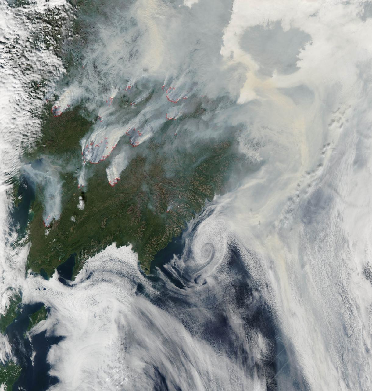
NASA image acquired August 1, 2010 Intense fires continued to burn in the boreal forests of eastern Siberia on August 1, 2010. The fires are outlined in red in this image, acquired by the Moderate Resolution Imaging Spectroradiometer (MODIS) on NASA’s Aqua satellite. The fires span the borders of Russia’s Chukotskiy, Magadan, and Koryakskiy provinces. Burning in coniferous (evergreen) forests, the fires blanketed northeastern Siberia with thick brown smoke. The smoke hugs the ground near the fires, filling valleys, and soars over clouds farther away from the flames. On August 1, the smoke flowed north from the fires and over the Arctic Ocean. A wide view of the Arctic shows the smoke crossing the Bering Strait and clouding skies over northern Alaska. This image is available in additional resolutions from the MODIS Rapid Response Team here: <a href="http://rapidfire.sci.gsfc.nasa.gov/gallery/?2010213-0801/Russia.A2010213.0045.2km.jpg" rel="nofollow">rapidfire.sci.gsfc.nasa.gov/gallery/?2010213-0801/Russia....</a> To view more images from this event go to: <a href="http://earthobservatory.nasa.gov/NaturalHazards/event.php?id=44561" rel="nofollow">earthobservatory.nasa.gov/NaturalHazards/event.php?id=44561</a> NASA image courtesy Jeff Schmaltz, MODIS Rapid Response Team at NASA GSFC. Caption by Holli Riebeek Instrument: Aqua - MODIS <b><a href="http://www.nasa.gov/centers/goddard/home/index.html" rel="nofollow">NASA Goddard Space Flight Center</a></b> is home to the nation's largest organization of combined scientists, engineers and technologists that build spacecraft, instruments and new technology to study the Earth, the sun, our solar system, and the universe. <b>Follow us on <a href="http://twitter.com/NASA_GoddardPix" rel="nofollow">Twitter</a></b> <b>Join us on <a href="http://www.facebook.com/pages/Greenbelt-MD/NASA-Goddard/395013845897?ref=tsd" rel="nofollow">Facebook</a><b></b></b>
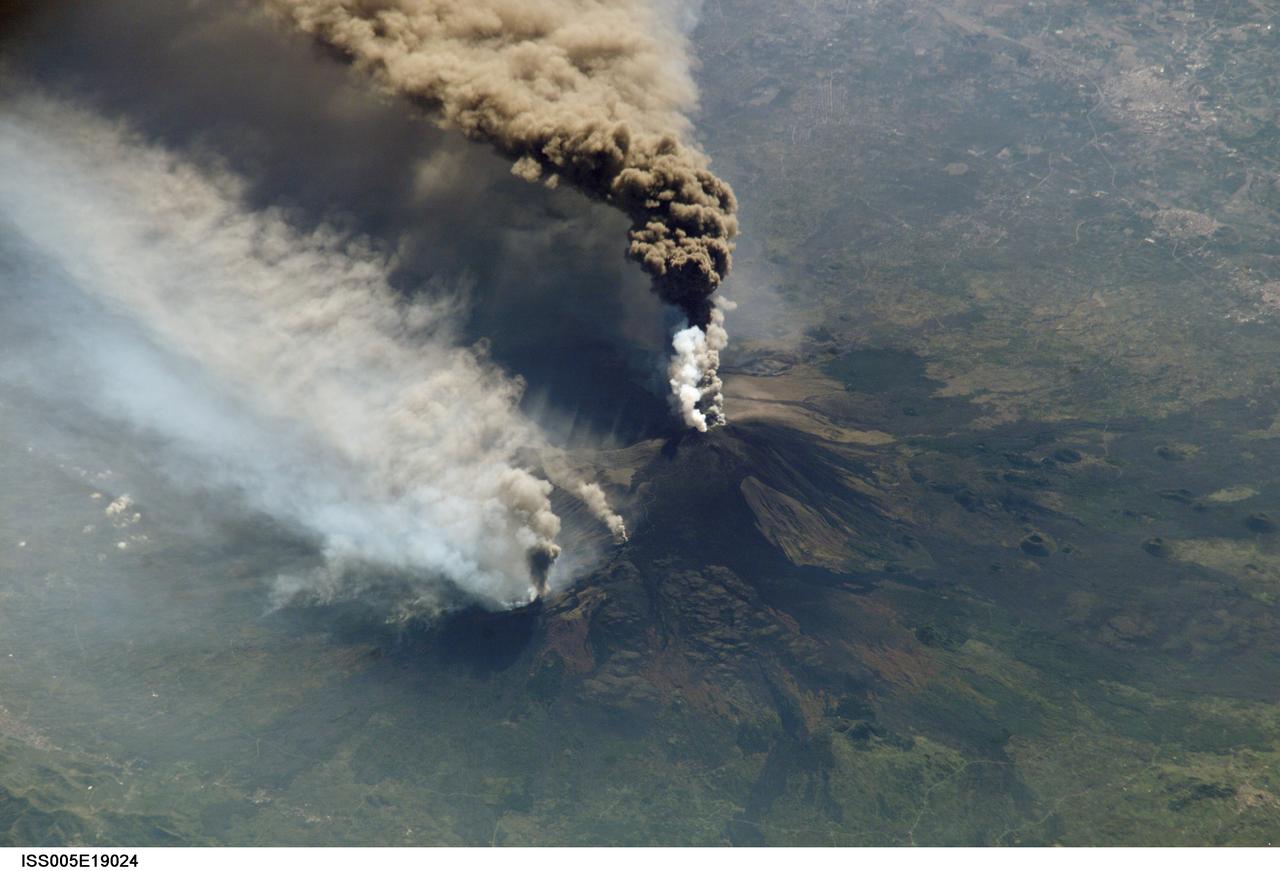
ISS005-E-19024 (30 October 2002) --- The three-member crew of the Expedition Five mission onboard the International Space Station was able to observe Mt. Etna’s spectacular eruption, and photograph the details of the eruption plume and smoke from fires triggered by the lava as it flowed down the 11,000 ft mountain. This image and a second image (ISS005-E-19016) are looking obliquely to the southeast over the island of Sicily. The wider view (ISS005-E-19024) shows the ash plume curving out toward the horizon, caught first by low-level winds blowing to the southeast, and to the south toward Africa at higher altitudes. Ashfall was reported in Libya, more than 350 miles away. The lighter-colored plumes downslope and north of the summit seen in this frame are produced by forest fires set by lava flowing into the pine forests on the slope of the mountain. This image provides a more three-dimensional profile of the eruption plume. This eruption was one of Etna’s most vigorous in years, volcanologists reported this week. The eruption was triggered by a series of earthquakes on October 27, 2002, they said. These images were taken on October 30. Although schools were closed and air traffic was diverted because of the ash, no towns or villages were reported to have been threatened by the lava flow.
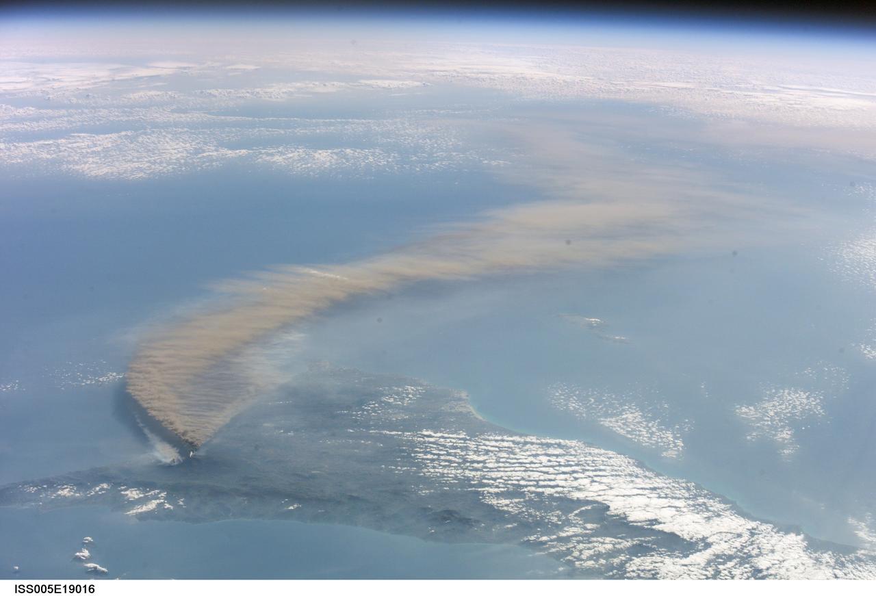
ISS005-E-19016 (30 October 2002) --- The three-member crew of the Expedition Five mission onboard the International Space Station was able to observe Mt. Etna’s spectacular eruption, and photograph the details of the eruption plume and smoke from fires triggered by the lava as it flowed down the 11,000 ft mountain. This image and a second image (ISS005-E-19024) are looking obliquely to the southeast over the island of Sicily. This wide view shows the ash plume curving out toward the horizon, caught first by low-level winds blowing to the southeast, and to the south toward Africa at higher altitudes. Ashfall was reported in Libya, more than 350 miles away. The lighter-colored plumes downslope and north of the summit (see detailed view taken the same day, ISS005-E-19024) are produced by forest fires set by lava flowing into the pine forests on the slope of the mountain. The detailed image provides a more three-dimensional profile of the eruption plume. This eruption was one of Etna’s most vigorous in years, volcanologists reported this week. The eruption was triggered by a series of earthquakes on October 27, 2002, they said. These images were taken on October 30. Although schools were closed and air traffic was diverted because of the ash, no towns or villages were reported to have been threatened by the lava flow.

Data from NASA's ECOSTRESS (Ecosystem Spaceborne Thermal Radiometer Experiment on Space Station) instrument aboard the International Space Station shows three wildfires burning in the mountains east and southeast of the Los Angeles area on Sept. 10, 2024. The Bridge Fire started Sept. 8 in the Angeles National Forest during an intense heat wave that blanketed the area for about a week. As of Sept. 13, the fire was only 3% contained. The Line Fire started Sept. 5 in Highland, within San Bernardino County, and spread toward the mountain communities of Running Springs and Big Bear. After more than a week of battling the blaze, firefighters had the conflagration 21% contained. The Airport Fire ignited Sept. 9 in the foothills of the Santa Ana Mountains east of the Orange County city of Irvine and spread into Riverside County. As of Sept. 13, it was 8% contained. The ECOSTRESS instrument measures the temperature of the land rather than air temperatures that most people are familiar with in weather forecasts. Bright white spots in the active fire areas in the visual above indicate a land surface temperature of over 300 degrees Fahrenheit (149 degrees Celsius). Dark red represents areas closer to 100 F (38 C). https://photojournal.jpl.nasa.gov/catalog/PIA26187
Very hot, dry and unstable conditions in California and across the Pacific Northwest add to the challenges facing firefighters as they battle blazes around the region. Cal Fire is urging Californians to be extremely cautious, especially for the next few days, as the current conditions increase the dangers authorities face. This image was taken by NASA-NOAA's Suomi NPP satellite's VIIRS instrument around 2145 UTC (5:45 p.m. EDT) on August 17, 2015. Northern California is seeing smoke from the River Complex, Route Complex, South Complex, Fork Complex and Mad River Complex fires combine over a large area of the Shasta-Trinity National Forest west of Redding, California, while the Rough Fire in Fresno County is spreading toward the Black Rock Reservoir, causing evacuations and road closures. Fires across the Pacific Northwest aren't limited to California. Please see the Suomi NPP VIIRS composites in NOAA View to see the growth and extent of fires over the past weeks. Credit: NASA/NOAA via <b><a href="www.nnvl.noaa.gov/" rel="nofollow"> NOAA Environmental Visualization Laboratory</a></b>
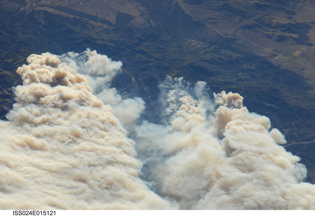
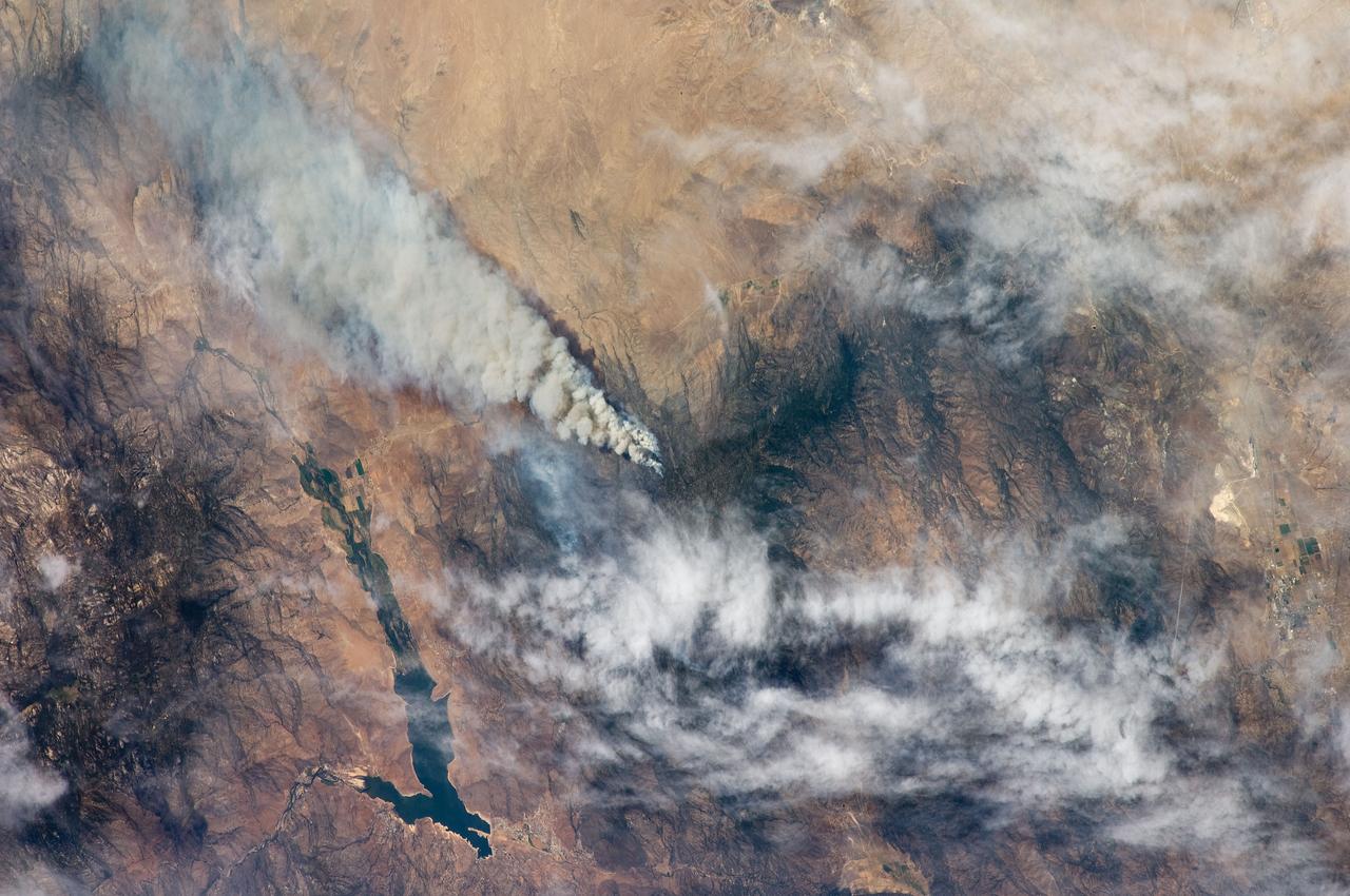
ISS024-E-015121 (20 Sept. 2010) --- Twitchell Canyon Fire in central Utah is featured in this image photographed by an Expedition 24 crew member on the International Space Station (ISS). The Twitchell Canyon Fire near central Utah?s Fishlake National Forest is reported to have an area of approximately 13,383 hectares (approximately 134 square kilometers, or 33,071 acres). This detailed image shows smoke plumes generated by several fire spots close to the southwestern edge of the burned area. The fire was started by a lightning strike on July 20, 2010. Whereas many of the space station images of Earth are looking straight down (nadir), this photograph was exposed at an angle. The space station was located over a point approximately 509 kilometers (316 miles) to the northeast, near the Colorado/Wyoming border, at the time the image was taken on Sept. 20. Southwesterly winds were continuing to extend smoke plumes from the fire to the northeast. While the Twitchell Canyon region is sparsely populated, Interstate Highway 15 is visible at upper left.
From left, Jon Wallace, deputy fire coordinator, U.S. Fish and Wildlife Service Southeast Region, Atlanta, Georgia; Chris Wilcox, U.S. Fish and Wildlife chief, Fire Management, National Interagency Fire Center, Boise, Idaho; and Mark Schollmeyer, chief, Brevard County Fire Rescue, pose for a portrait following a ceremony Nov. 1 on the Merritt Island National Wildlife Refuge in Florida. During the joint ceremony, the Spaceport Integration Team and its partners were presented with the prestigious 2017 Pulaski Award and a new memorial marker was dedicated. The multi-agency team includes representatives from NASA's Kennedy Space Center, Cape Canaveral Air Force Station's 45th Space Wing, the Merritt Island National Wildlife Refuge, as well as the Florida Forest Service and Brevard County Fire Rescue. The memorial marker honors two fallen firefighters, Scott Maness and Beau Sauselein, who died fighting a wildfire on space center property in 1981. Held outdoors, the ceremony was attended by 140 guests.
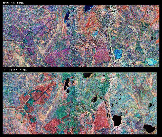
This is a comparison of images over Prince Albert, produced by NASA Spaceborne Imaging Radar-C and X-band Synthetic Aperture Radar aboard the space shuttle Endeavour on its 20th orbit on April 10, 1994. The area is centered at 53.91 degrees north latitude and 104.69 degrees west longitude and is located 40 kilometers (25 miles) north and 30 kilometers (18.5 miles) east of the town of Prince Albert in the Saskatchewan province of Canada. The image covers the area east of Candle Lake, between the gravel highway of 120 and west of highway 106. The area imaged is near the southern limit of the boreal forest. The boreal forest of North America is a continuous vegetation belt at high latitudes stretching across the continent from the Atlantic shoreline of central Labrador and then westward across Canada to the interior mountains and central coastal plains of Alaska. The forest is also part of a larger northern hemisphere circumpolar boreal forest belt. Coniferous trees dominate the entire forest but deciduous trees are also present. During the month of April, the forest experiences seasonal changes from a frozen condition to a thawed condition. The trees are completely frozen over the winter season and the forest floor is covered by snow. As the average temperature rises in the spring, the trees are thawed and the snow melts. This transition has an impact on the rate of moisture evaporation and release of carbon dioxide into the atmosphere. In late September and early October, the boreal forest experiences a relatively different seasonal change. At this time, the leaves on deciduous trees start changing color and dropping off. The soil and trees are quite often moist due to frequent rainfall and cloud cover. The evaporation of moisture and carbon dioxide into the atmosphere also diminishes at this time. SIR-C/X-SAR is sensitive to the moisture of soil and vegetation and can sense this freeze-thaw cycle and the summer-fall seasonal transition over forested areas in particular. Optical sensors, by contrast, are blind to these regions, which are perpetually obscured by thick cloud cover. These changes were detected by comparing the April and October color composite images of L-band data in red, C-band data in green and X-band (vertically received and transmitted) in blue. The changes in intensity of each color over lakes, various forest stands and clear cuts in the two images is striking. Lakes such as Lake Heiberg, Crabtree Lake and Williams Lake, in the right middle part of the image, are frozen in April (appearing in bright blue) and melted (appearing in black) in October. The higher intensity of blue over lakes in April is due to low penetration of the X-band (vertically received and transmitted) and the radar's high sensitivity to surface features. Forest stands also exhibit major changes between the two images. The red areas in the October image are old jack pine canopies that cause higher return at L-band because of their moist condition in late summer compared to their partially frozen condition in April (in purple). Similarly, in the areas near the middle of the image, where black spruce and mixed aspen and jack pine trees dominate, the contrast between blue in October and red and green in April is an indication that the top of the canopy (needles and branches) were frozen in April and moist in October. The changes due to deforestation by logging companies or natural fires can also be detected by comparing the images. For example, the small blue area near the intersection of Harding Road and Highway 120 is the result of logging which occurred after the April data was acquired. The surface area of clear cut is approximately 4 hectares, which is calculated from the high-resolution capability of the radar images and verified by scientists participating in field work during the mission. http://photojournal.jpl.nasa.gov/catalog/PIA01732
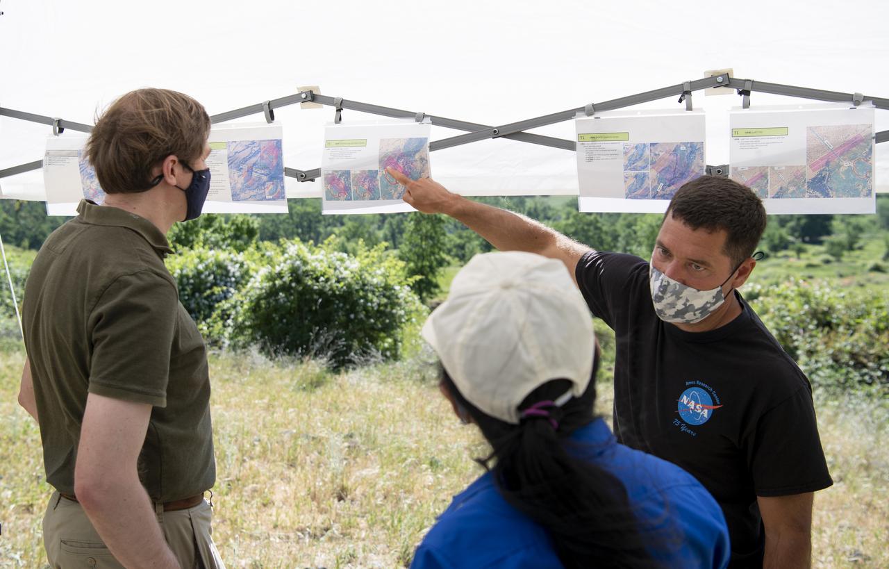
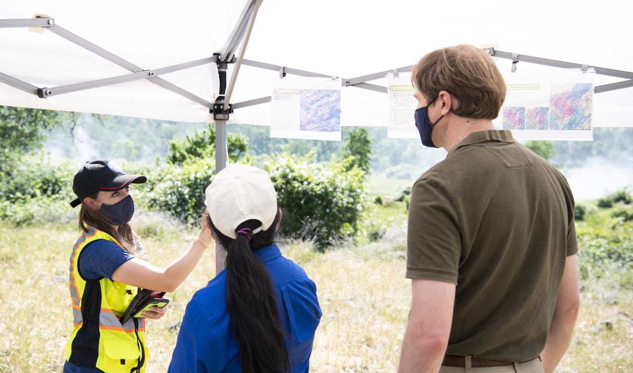
Joey Mercer, principle investigator for STEReO, the Scalable Traffic Management for Emergency Response Operations project, at NASA's Ames Research Center speaks with Richard Barhydt, station director of the U.S. Forest Service's Pacific Southwest Research Station and Huy Tran, director of aeronautics at NASA's Ames Research Center, during STEReO test activities, Tuesday, May 4, 2021 as Cal Fire conducts aerial fire fighting training exercises near Redding, California. STEReO, the Scalable Traffic Management for Emergency Response Operations project, led by NASA’s Ames Research Center, builds on NASA’s expertise in air traffic management, human factors research, and autonomous technology development to apply the agency’s work in Unmanned Aircraft Systems Traffic Management, or UTM, to public safety uses. Photo Credit: (NASA/Joel Kowsky)
STS093-709-046 (23-27 July 1999) --- The STS-93 astronauts aboard the Space Shuttle Columbia took this picture featuring the Northern Territory of Australia. Melville Island (bottom) and Bathurst Island are across Clarence Strait just north of the city of Darwin. According to scientists studying the STS-93 photo collection, seasonal fires are common in the region. Winter is the season for agricultural land clearing of the native monsoon forests. Smoke from the fires on the islands is being blown northwest by the prevailing winter winds. Data back information on the 70mm film that recorded this image lists time and date as 05:38:45 GMT, July 25, 1999. When the photo was taken, the shuttle was flying over a point located at 18.4 degrees south latitude and 118.7 east longitude.
Joey Mercer, principle investigator for STEReO, the Scalable Traffic Management for Emergency Response Operations project, at NASA's Ames Research Center, center, speaks with Richard Barhydt, station director of the U.S. Forest Service's Pacific Southwest Research Station, left, and Huy Tran, director of aeronautics at NASA's Ames Research Center, right, during STEReO test activities, Tuesday, May 4, 2021 as Cal Fire conducts aerial fire fighting training exercises near Redding, California. STEReO, the Scalable Traffic Management for Emergency Response Operations project, led by NASA’s Ames Research Center, builds on NASA’s expertise in air traffic management, human factors research, and autonomous technology development to apply the agency’s work in Unmanned Aircraft Systems Traffic Management, or UTM, to public safety uses. Photo Credit: (NASA/Joel Kowsky)
On June 26, NASA's Terra satellite acquired this image of the Aspen fire burning out of control north of Tucson, AZ. As of that date, the fire had consumed more than 27,000 acres and destroyed more than 300 homes, mostly in the resort community of Summerhaven, according to news reports. These data are being used by NASA's Wildfire Response Team and the US Forest Service to assess the intensity of the burn for future remediation efforts. This image was acquired on June 26, 2003 by the Advanced Spaceborne Thermal Emission and Reflection Radiometer (ASTER) on Terra. With its 14 spectral bands from the visible to the thermal infrared wavelength region, and its high spatial resolution of 15 to 90 meters (about 50 to 300 feet), ASTER images Earth to map and monitor the changing surface of our planet. http://photojournal.jpl.nasa.gov/catalog/PIA04602
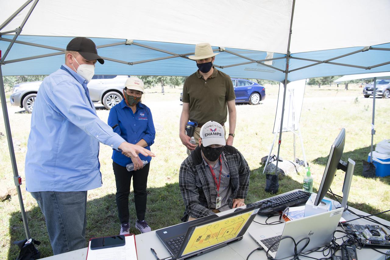
Joey Mercer, principle investigator for STEReO, the Scalable Traffic Management for Emergency Response Operations project, at NASA's Ames Research Center, left, Huy Tran, director of aeronautics at NASA's Ames Research Center, center, and Richard Barhydt, station director of the U.S. Forest Service's Pacific Southwest Research Station, standing right, speak with George Lawton, system architect for STEReO at NASA's Ames Research Center, seated right, during STEReO test activities, Tuesday, May 4, 2021 as Cal Fire conducts aerial fire fighting training exercises near Redding, California. STEReO, the Scalable Traffic Management for Emergency Response Operations project, led by NASA’s Ames Research Center, builds on NASA’s expertise in air traffic management, human factors research, and autonomous technology development to apply the agency’s work in Unmanned Aircraft Systems Traffic Management, or UTM, to public safety uses. Photo Credit: (NASA/Joel Kowsky)
Joey Mercer, principle investigator for STEReO, the Scalable Traffic Management for Emergency Response Operations project, at NASA's Ames Research Center, right, speaks with Richard Barhydt, station director of the U.S. Forest Service's Pacific Southwest Research Station, left, and Huy Tran, director of aeronautics at NASA's Ames Research Center, center, during STEReO test activities, Tuesday, May 4, 2021 as Cal Fire conducts aerial fire fighting training exercises near Redding, California. STEReO, the Scalable Traffic Management for Emergency Response Operations project, led by NASA’s Ames Research Center, builds on NASA’s expertise in air traffic management, human factors research, and autonomous technology development to apply the agency’s work in Unmanned Aircraft Systems Traffic Management, or UTM, to public safety uses. Photo Credit: (NASA/Joel Kowsky)
Joey Mercer, principle investigator for STEReO, the Scalable Traffic Management for Emergency Response Operations project, at NASA's Ames Research Center, right, speaks with Richard Barhydt, station director of the U.S. Forest Service's Pacific Southwest Research Station, left, and Huy Tran, director of aeronautics at NASA's Ames Research Center, center, during STEReO test activities, Tuesday, May 4, 2021 as Cal Fire conducts aerial fire fighting training exercises near Redding, California. STEReO, the Scalable Traffic Management for Emergency Response Operations project, led by NASA’s Ames Research Center, builds on NASA’s expertise in air traffic management, human factors research, and autonomous technology development to apply the agency’s work in Unmanned Aircraft Systems Traffic Management, or UTM, to public safety uses. Photo Credit: (NASA/Joel Kowsky)
Joey Mercer, principle investigator for STEReO, the Scalable Traffic Management for Emergency Response Operations project, at NASA's Ames Research Center , right, speaks with Richard Barhydt, station director of the U.S. Forest Service's Pacific Southwest Research Station, left, during STEReO test activities, Tuesday, May 4, 2021 as Cal Fire conducts aerial fire fighting training exercises near Redding, California. STEReO, the Scalable Traffic Management for Emergency Response Operations project, led by NASA’s Ames Research Center, builds on NASA’s expertise in air traffic management, human factors research, and autonomous technology development to apply the agency’s work in Unmanned Aircraft Systems Traffic Management, or UTM, to public safety uses. Photo Credit: (NASA/Joel Kowsky)
Lauren Claudatos, researcher for STEReO, the Scalable Traffic Management for Emergency Response Operations project, at NASA's Ames Research Center, right, speaks with Richard Barhydt, station director of the U.S. Forest Service's Pacific Southwest Research Station, left, and Huy Tran, director of aeronautics at NASA's Ames Research Center, center, during STEReO test activities, Tuesday, May 4, 2021 as Cal Fire conducts aerial fire fighting training exercises near Redding, California. STEReO, the Scalable Traffic Management for Emergency Response Operations project, led by NASA’s Ames Research Center, builds on NASA’s expertise in air traffic management, human factors research, and autonomous technology development to apply the agency’s work in Unmanned Aircraft Systems Traffic Management, or UTM, to public safety uses. Photo Credit: (NASA/Joel Kowsky)

Joey Mercer, principle investigator for STEReO, the Scalable Traffic Management for Emergency Response Operations project, at NASA's Ames Research Center speaks with Richard Barhydt, station director of the U.S. Forest Service's Pacific Southwest Research Station and Huy Tran, director of aeronautics at NASA's Ames Research Center, during STEReO test activities, Tuesday, May 4, 2021 as Cal Fire conducts aerial fire fighting training exercises near Redding, California. STEReO, the Scalable Traffic Management for Emergency Response Operations project, led by NASA’s Ames Research Center, builds on NASA’s expertise in air traffic management, human factors research, and autonomous technology development to apply the agency’s work in Unmanned Aircraft Systems Traffic Management, or UTM, to public safety uses. Photo Credit: (NASA/Joel Kowsky)
Robert McSwain, co-principle investigator and autonomy researcher for STEReO, the Scalable Traffic Management for Emergency Response Operations project, at NASA's Langley Research Center, left, speaks with Huy Tran, director of aeronautics at NASA's Ames Research Center, center, and Richard Barhydt, station director of the U.S. Forest Service's Pacific Southwest Research Station, right, during STEReO test activities, Tuesday, May 4, 2021 as Cal Fire conducts aerial fire fighting training exercises near Redding, California. STEReO, the Scalable Traffic Management for Emergency Response Operations project, led by NASA’s Ames Research Center, builds on NASA’s expertise in air traffic management, human factors research, and autonomous technology development to apply the agency’s work in Unmanned Aircraft Systems Traffic Management, or UTM, to public safety uses. Photo Credit: (NASA/Joel Kowsky)
Robert McSwain, co-principle investigator and autonomy researcher for STEReO, the Scalable Traffic Management for Emergency Response Operations project, at NASA's Langley Research Center, left, speaks with Huy Tran, director of aeronautics at NASA's Ames Research Center, center, and Richard Barhydt, station director of the U.S. Forest Service's Pacific Southwest Research Station, right, during STEReO test activities, Tuesday, May 4, 2021 as Cal Fire conducts aerial fire fighting training exercises near Redding, California. STEReO, the Scalable Traffic Management for Emergency Response Operations project, led by NASA’s Ames Research Center, builds on NASA’s expertise in air traffic management, human factors research, and autonomous technology development to apply the agency’s work in Unmanned Aircraft Systems Traffic Management, or UTM, to public safety uses. Photo Credit: (NASA/Joel Kowsky)
Lauren Claudatos, researcher for STEReO, the Scalable Traffic Management for Emergency Response Operations project, at NASA's Ames Research Center, right, speaks with Richard Barhydt, station director of the U.S. Forest Service's Pacific Southwest Research Station, left, and Huy Tran, director of aeronautics at NASA's Ames Research Center, center, during STEReO test activities, Tuesday, May 4, 2021 as Cal Fire conducts aerial fire fighting training exercises near Redding, California. STEReO, the Scalable Traffic Management for Emergency Response Operations project, led by NASA’s Ames Research Center, builds on NASA’s expertise in air traffic management, human factors research, and autonomous technology development to apply the agency’s work in Unmanned Aircraft Systems Traffic Management, or UTM, to public safety uses. Photo Credit: (NASA/Joel Kowsky)
Joey Mercer, principle investigator for STEReO, the Scalable Traffic Management for Emergency Response Operations project, at NASA's Ames Research Center, right, speaks with Richard Barhydt, station director of the U.S. Forest Service's Pacific Southwest Research Station, left, and Huy Tran, director of aeronautics at NASA's Ames Research Center, center, during STEReO test activities, Tuesday, May 4, 2021 as Cal Fire conducts aerial fire fighting training exercises near Redding, California. STEReO, the Scalable Traffic Management for Emergency Response Operations project, led by NASA’s Ames Research Center, builds on NASA’s expertise in air traffic management, human factors research, and autonomous technology development to apply the agency’s work in Unmanned Aircraft Systems Traffic Management, or UTM, to public safety uses. Photo Credit: (NASA/Joel Kowsky)
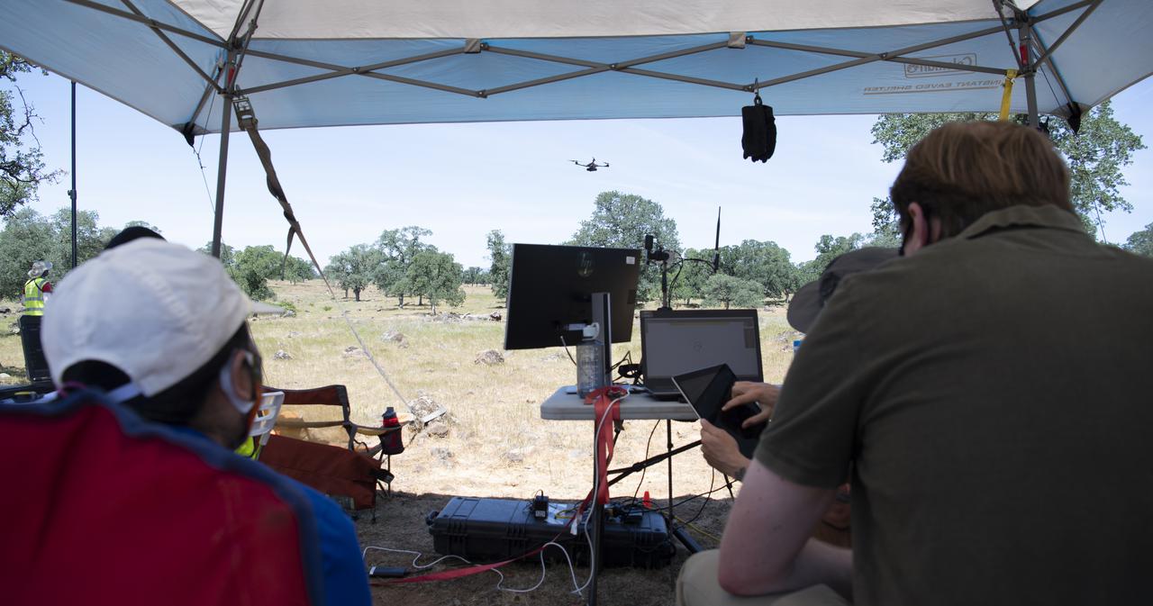
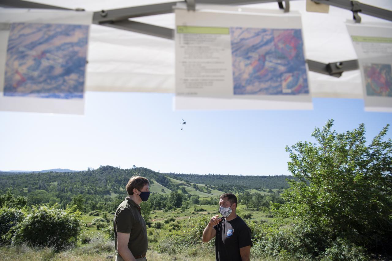
Huy Tran, director of aeronautics at NASA's Ames Research Center, left, and Richard Barhydt, station director of the U.S. Forest Service's Pacific Southwest Research Station, right, observe a flight by a FreeFly Systems Alta X drone as part of STEReO, the Scalable Traffic Management for Emergency Response Operations project, test activities, Tuesday, May 4, 2021 as Cal Fire conducts aerial fire fighting training exercises near Redding, California. STEReO, the Scalable Traffic Management for Emergency Response Operations project, led by NASA’s Ames Research Center, builds on NASA’s expertise in air traffic management, human factors research, and autonomous technology development to apply the agency’s work in Unmanned Aircraft Systems Traffic Management, or UTM, to public safety uses. Photo Credit: (NASA/Joel Kowsky)
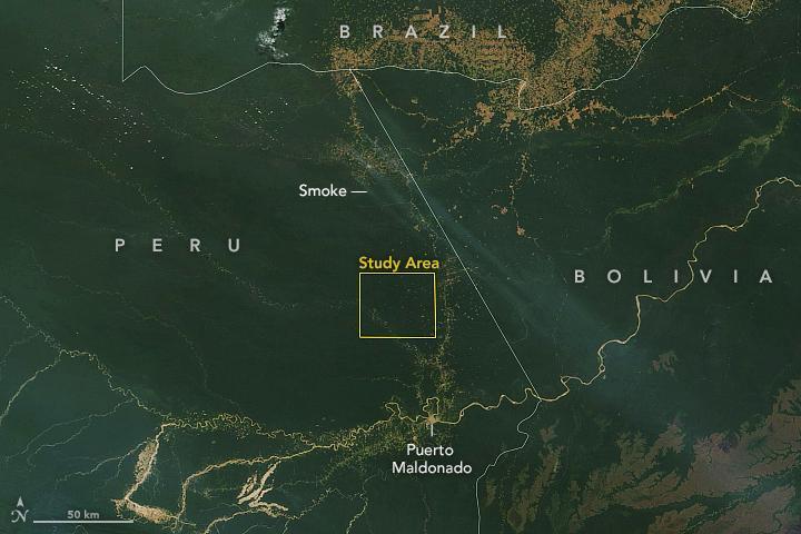
ISS040-E-103496 (19 Aug. 2014) --- On an unusually cloud-free day at the height of the dry season in Amazonia, several fires were burning, giving rise to a broad smoke pall easily seen from the International Space Station, photographed by an Expedition 40 crew member. Parts of the space station appear along the margins of the image. Against the backdrop of the dark green rainforest, several fires follow the major highway BR 163 (lower center of the image to the top left). Fires are set to clear patches of forest for agriculture, a process that reveals red-brown soils. A long line of new cleared patches snakes east from BR 163 towards the remote valley of the Rio Crepori. Extensive deforested areas in Brazil?s state of Mato Grosso appear as tan areas across the top of the image. Fires show the advance of deforestation into the state of Para, the area shown in most of this view. Para is now second after Mato Grosso in terms of deforestation acreage.
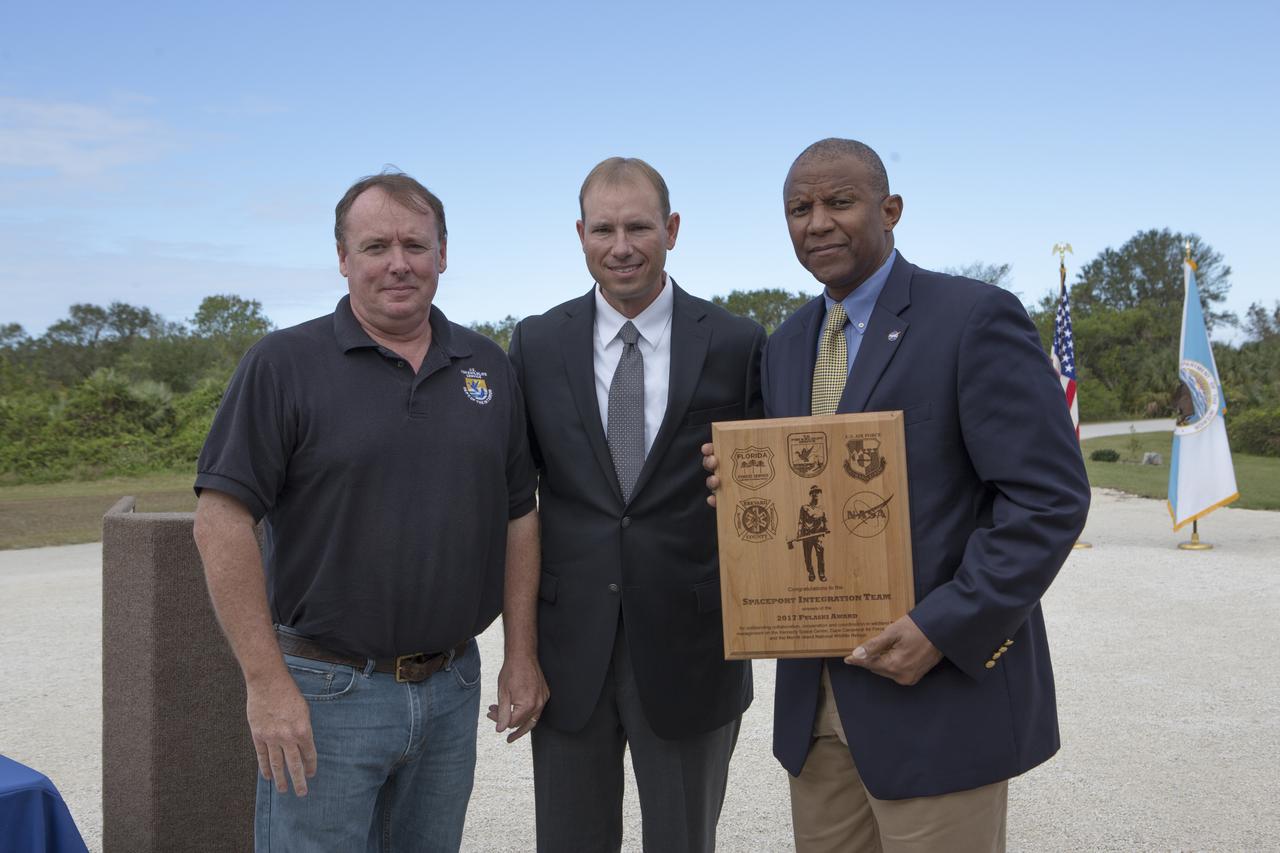
From left, Jon Wallace, deputy fire coordinator, U.S. Fish and Wildlife Service Southeast Region, Atlanta, Georgia; Chris Wilcox, U.S. Fish and Wildlife chief, Fire Management, National Interagency Fire Center, Boise, Idaho; and Kelvin Manning, associate director, NASA's Kennedy Space Center, pose for a portrait following a ceremony Nov. 1 on the Merritt Island National Wildlife Refuge in Florida. During the joint ceremony, the Spaceport Integration Team and its partners were presented with the prestigious 2017 Pulaski Award and a new memorial marker was dedicated. The multi-agency team includes representatives from NASA's Kennedy Space Center, Cape Canaveral Air Force Station's 45th Space Wing, the Merritt Island National Wildlife Refuge, as well as the Florida Forest Service and Brevard County Fire Rescue. The memorial marker honors two fallen firefighters, Scott Maness and Beau Sauselein, who died fighting a wildfire on space center property in 1981. Held outdoors, the ceremony was attended by 140 guests.
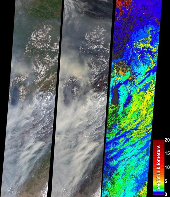
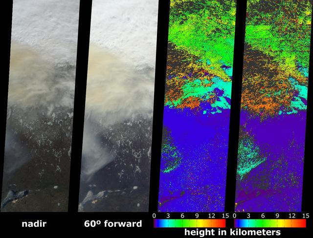
This full-frame ASTER image, acquired August 30, 2000, covers an area of 60 by 60 km in the Salmon River Mountains, Idaho. In this color infrared composite, vegetation is red, clouds are white, and smoke from forest fires is blue. An enlargement (Figure 1) covers an area of 12 x 15 km. A thermal infrared band is displayed in red, a short wave infrared band is displayed in green, and a visible band is displayed in blue. In this combination, fires larger than about 50 m appear yellow because they are bright in both infrared bands. Smaller fires appear green because they are too small to be seen by the 90 m thermal pixels, but large enough to be detected in the 30 m short wave infrared pixels. We are able to see through the smoke in the infrared bands, whereas in the visible bands, the smoke obscures detection of the active fires. This image is located at 44.8 degrees north latitude and 114.8 degrees west longitude. http://photojournal.jpl.nasa.gov/catalog/PIA11088
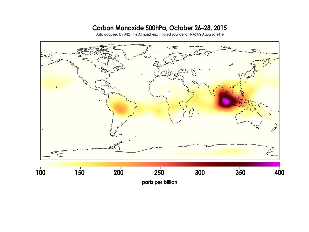
Widespread forest fires across Indonesia have burned tens of thousands of acres over three months, causing high levels of pollution, loss of life, and billions of dollars to the Indonesian government. It is estimated that more than 43 million people have been inhaling toxic fumes, and large parts of Indonesia have been placed in a state of emergency. Most of the fires are believed to have been set to clear farmland during the dry season, but a long term drought enhanced by El Niño conditions have contributed to the fires remaining unchecked due to lack of rain. These images made with data acquired by AIRS, the Atmospheric Infrared Sounder on NASA's Aqua Satellite, show the global concentration of carbon monoxide at the 500hPa pressure level, or approximately 18,000 feet (5,500 meters) altitude. The data are an average of measurements taken over three days, from October 14 through 16, and October 26 through 28, and the high concentration and large extent of the fires over Indonesia are quite apparent. While the scale for this image extends to 400 parts per billion, local values of carbon monoxide can be significantly higher. http://photojournal.jpl.nasa.gov/catalog/PIA20042
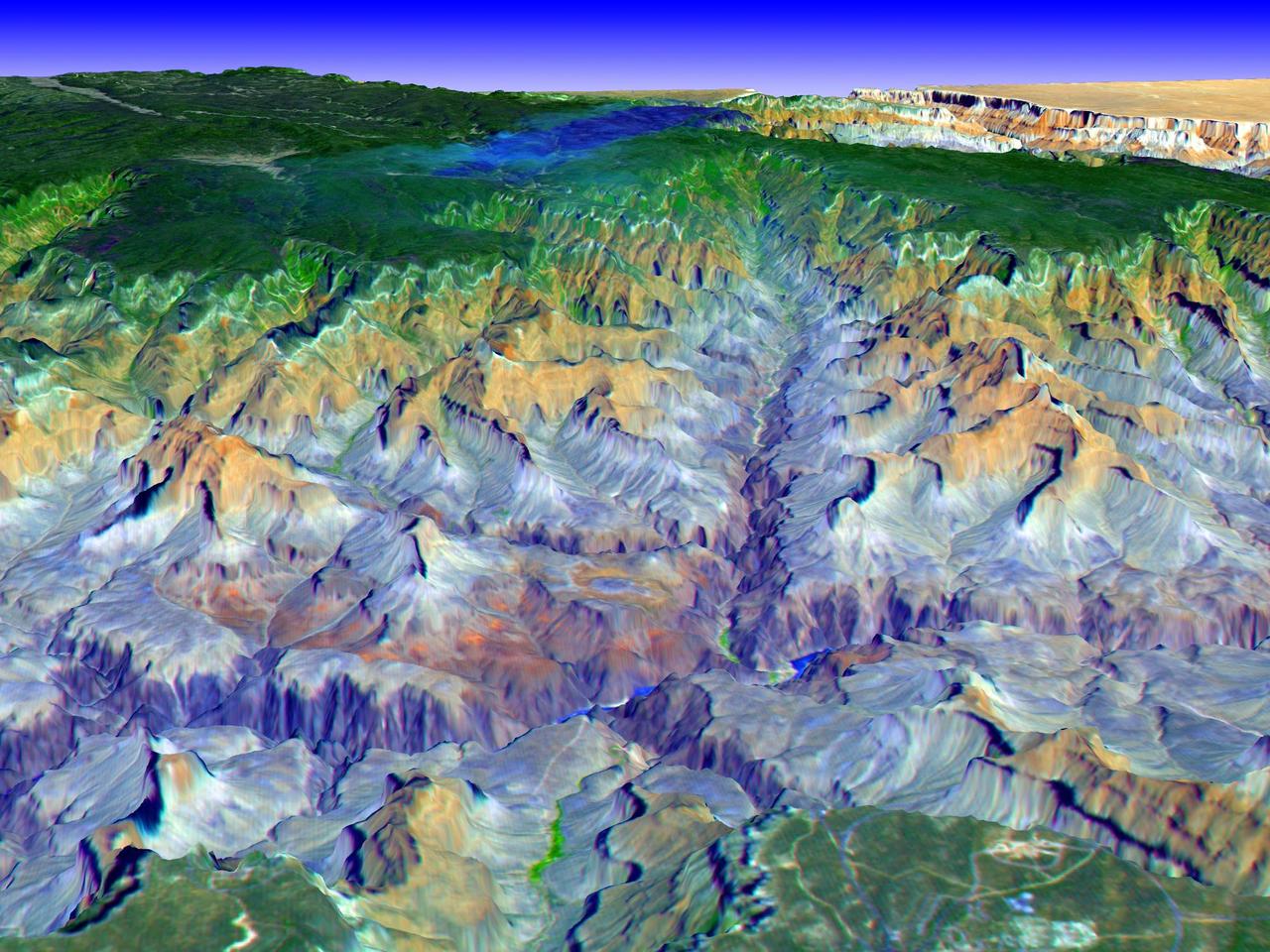
This simulated true color perspective view over the Grand Canyon was created from Advanced Spaceborne Thermal Emission and Reflection Radiometer (ASTER) data acquired on May 12, 2000. The Grand Canyon Village is in the lower foreground; the Bright Angel Trail crosses the Tonto Platform, before dropping down to the Colorado Village and then to the Phantom Ranch (green area across the river). Bright Angel Canyon and the North Rim dominate the view. At the top center of the image the dark blue area with light blue haze is an active forest fire. http://photojournal.jpl.nasa.gov/catalog/PIA01908
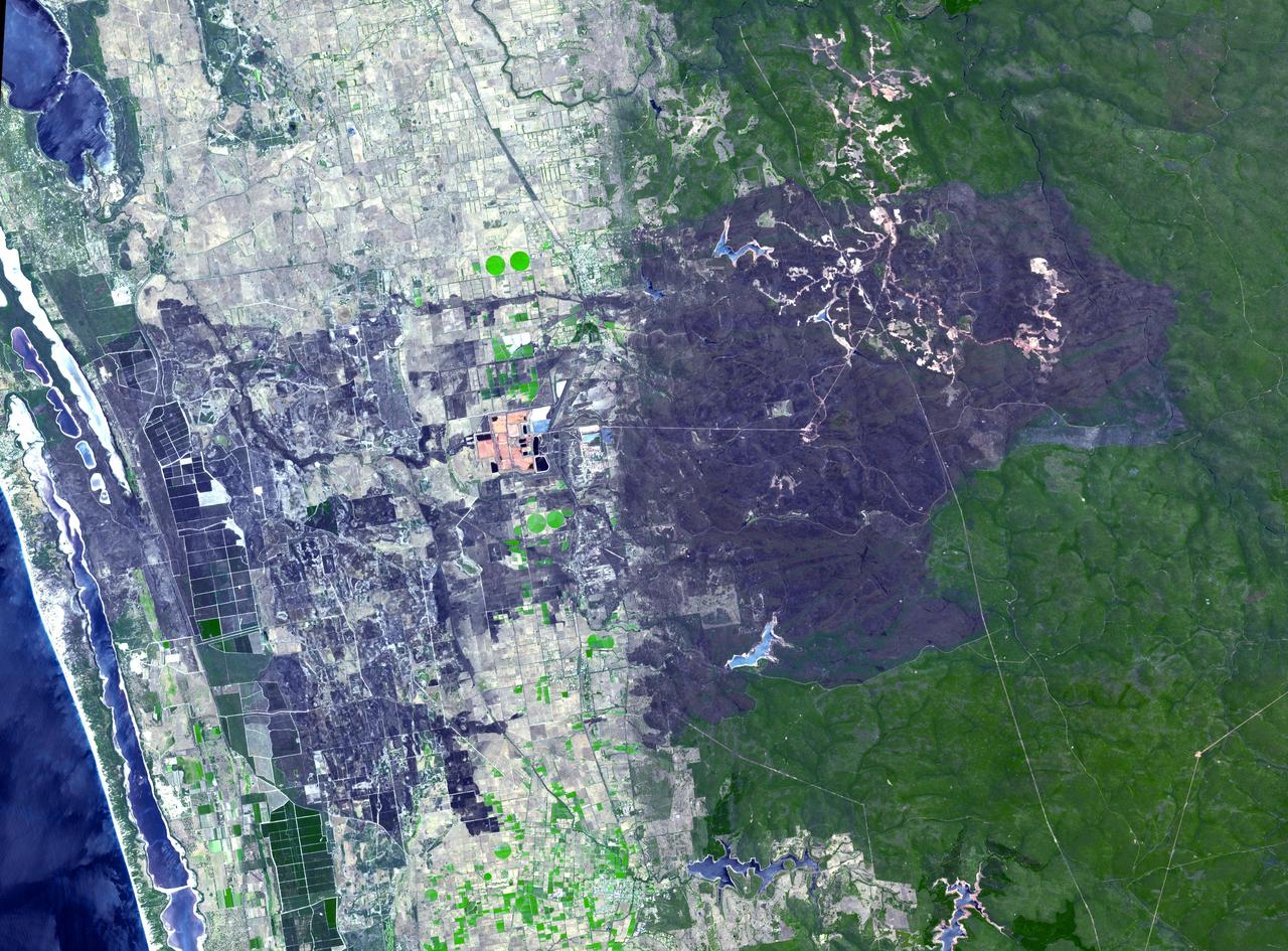
The summer, dry season in Australia is marked by small to massive bushfires. The remote town of Yarloop, about 75 miles (120 kilometers) south of the Western Australian capital of Perth, was destroyed as part of a 100,000-acre (405-square kilometer) blaze that started on January 7, 2016. The fire burned trees in the forested mountains, and extended down to the coast. This image, from the Advanced Spaceborne Thermal Emission and Reflection Radiometer (ASTER) instrument on NASA's Terra spacecraft, covers an area of 25 by 34 miles (40 by 54 kilometers). It was acquired Jan. 15, 2016, and is located at 32.9 degrees south, 115.9 degrees east. http://photojournal.jpl.nasa.gov/catalog/PIA20363

California has been hit hard the past few weeks with storms. Storms bring lightning and lightning strikes cause wildfires. Currently there are at least five fire complexes in the area including River, Fork, South, Route and Mad River. The Mad River complex is a series of seven lightning fires that started on July 30th, 2015 after a lightning storm moved through Northern California. After initial firefighters responded, 25 fires were reported and most of the fires were contained. Some additional fires might be detected from the original lightning storms in the upcoming days and will be attacked once they are found. Damage assessment is ongoing and crews will determine the extent of structures and equipment damaged or destroyed. The River Complex is managing a total of 5 fires due to fires merging together on the Shasta-Trinity and the Six Rivers National Forests. Winds from the west are expected to lift the inversion today resulting in active fire behavior. The Fork Complex consists of over 40 fires, all of which were ignited by lightning between July 29 and 31, 2015. These fires are still being identified, assessed, and prioritized. Updated acreage and information about specific fires will be published as it is known. Fire activity moderated throughout last night (8/4) with the smoke inversion layer remaining in place today. Hopefully this will create favorable conditions for fire crews to take direct fire attack on the fires edge, construct dozer line and scout for best firefighting locations on all fires in the complex. The South Complex consists of approximately nine known fires, five of which are currently over 100 acres. The fires are active and defense of structures and point protection are in progress. The weather is trapping smoke in the valley causing very poor air quality. As the smoke lifts the fire activity increases. Firefighters will continue to provide point protection on structures and to look for opportunities to build direct and indirect containment lines. The Route Complex currently stands at 12,164 acres from seven separate fires and is at 2% containment. The overall acreage has been reduced because the South Fire on the nearby South Complex is merging with the Johnson Fire in the Route Complex resulting in decreased and revised fire perimeter acreage. This natural-color satellite image collected by the Moderate Resolution Imaging Spectroradiometer (MODIS) aboard the Terra satellite shows smoke rising and drifting northwest from the various fire complexes. It was captured on August 04, 2015. Actively burning areas, detected by MODIS’s thermal bands, are outlined in red. NASA image courtesy Jeff Schmaltz, MODIS Rapid Response Team. <b><a href="http://www.nasa.gov/audience/formedia/features/MP_Photo_Guidelines.html" rel="nofollow">NASA image use policy.</a></b> <b><a href="http://www.nasa.gov/centers/goddard/home/index.html" rel="nofollow">NASA Goddard Space Flight Center</a></b> enables NASA’s mission through four scientific endeavors: Earth Science, Heliophysics, Solar System Exploration, and Astrophysics. Goddard plays a leading role in NASA’s accomplishments by contributing compelling scientific knowledge to advance the Agency’s mission. <b>Follow us on <a href="http://twitter.com/NASAGoddardPix" rel="nofollow">Twitter</a></b> <b>Like us on <a href="http://www.facebook.com/pages/Greenbelt-MD/NASA-Goddard/395013845897?ref=tsd" rel="nofollow">Facebook</a></b> <b>Find us on <a href="http://instagrid.me/nasagoddard/?vm=grid" rel="nofollow">Instagram</a></b>
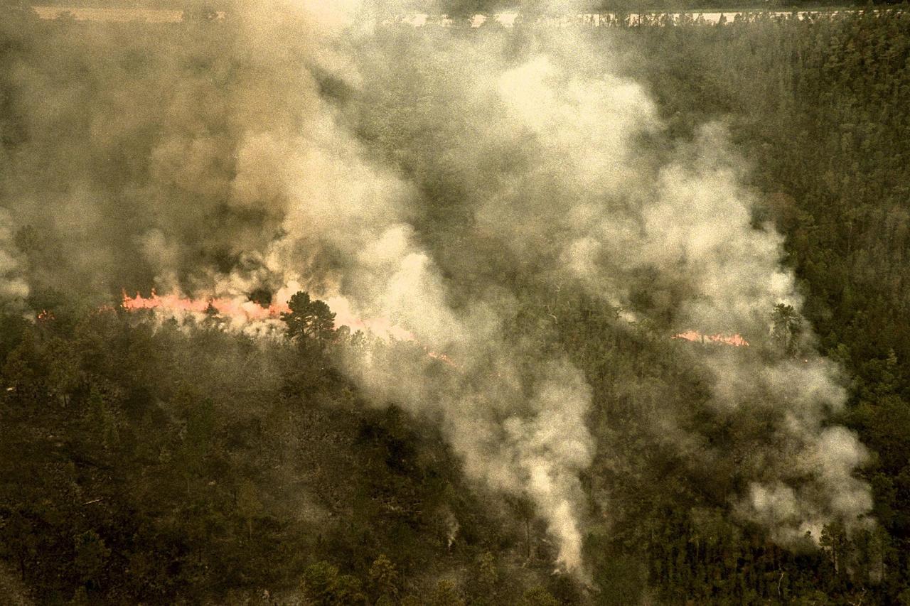
KENNEDY SPACE CENTER, FLA. -- A forest fire burning in Volusia County, Florida, is clearly visible from NASA's Huey UH-1 helicopter. The helicopter has been outfitted with a Forward Looking Infrared Radar (FLIR) and a portable global positioning satellite (GPS) system to support Florida's Division of Forestry as they fight the brush fires which have been plaguing the state as a result of extremely dry conditions and lightning storms. The FLIR includes a beach ball-sized infrared camera that is mounted on the helicopter's right siderail and a real-time television monitor and recorder installed inside. While the FLIR collects temperature data and images, the GPS system provides the exact coordinates of the fires being observed and transmits the data to the firefighters on the ground. The Kennedy Space Center (KSC) security team routinely uses the FLIR equipment prior to Shuttle launch and landing activities to ensure that the area surrounding the launch pad and runway are clear of unauthorized personnel. KSC's Base Operations Contractor, EG&G Florida, operates the NASA-owned helicopter
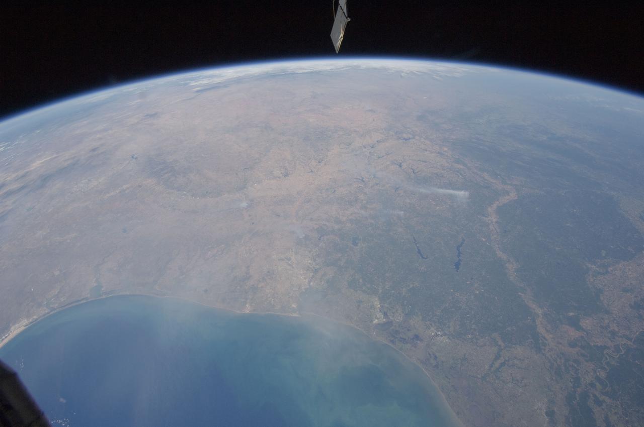
ISS028-E-037978 (6 Sept. 2011) --- Wildfire smoke plumes in Texas are featured in this image photographed by an Expedition 28 crew member on the International Space Station. This panoramic view of east-central Texas highlights numerous smoke plumes caused by wildfires burning across the state. The image was taken using a short focal length lens (12-mm), which captures a wide field of view at the cost of fine feature resolution. Smoke plumes are clearly visible in the image to the east of Austin; to the north of Houston; to the northwest of Lake Sam Rayburn and Toledo Bend Reservoir; and to the west of Shreveport, LA. More diffuse smoke moving offshore into the Gulf of Mexico is visible at bottom. Part of an ISS photovoltaic radiator panel is visible at top center. Record-setting drought conditions have affected much of Texas since early 2011 and have dried out both forest and grassland, providing ample fuel for wildfires. Relatively high winds and low humidity levels have also contributed to the rapid spread and expansion of fires. According to a Texas Forest Service (TXFS) Incident Management Situation Report dated Sept. 7, 2011, TXFS had responded to 172 fires affecting an area of 546.53 square kilometers (135,051 acres) over the preceding seven days. Fires near Bastrop, TX to the east of Austin had destroyed 785 homes as of Sept. 7, 2011.