An artist’s concept of the transonic truss-braced wing aircraft configuration in flight over a forest of trees.
An artist’s concept of the transonic truss-braced wing aircraft configuration in flight over a forest of trees.
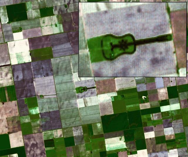
Located in the fertile agricultural region of Argentina Pampas is a guitar-shaped forest made up of cypress and eucalyptus trees as seen by NASA Terra spacecraft.
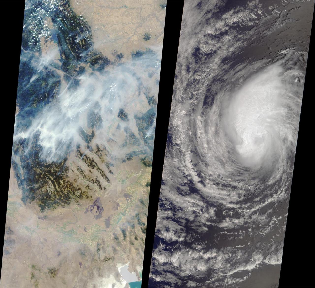
These images from NASA Terra satellite captured on August 14, 2000 show forest fires raging in Montana and Hurricane Hector swirling in the Pacific.
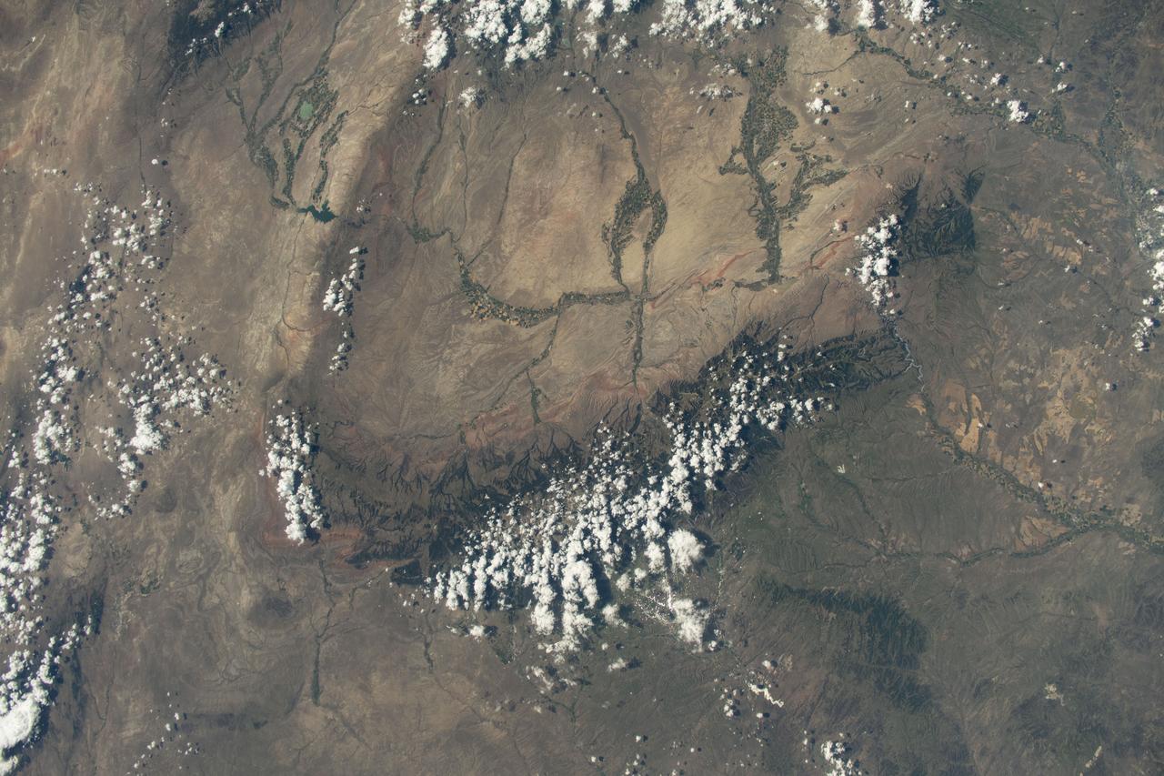
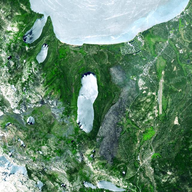
iss073e0420598 (Aug. 3, 2025) --- Bighorn National Forest in Wyoming and Custer National Forest in Montana, located in the Rocky Mountains region of the United States, are pictured from the International Space Station as it orbited 261 miles above.
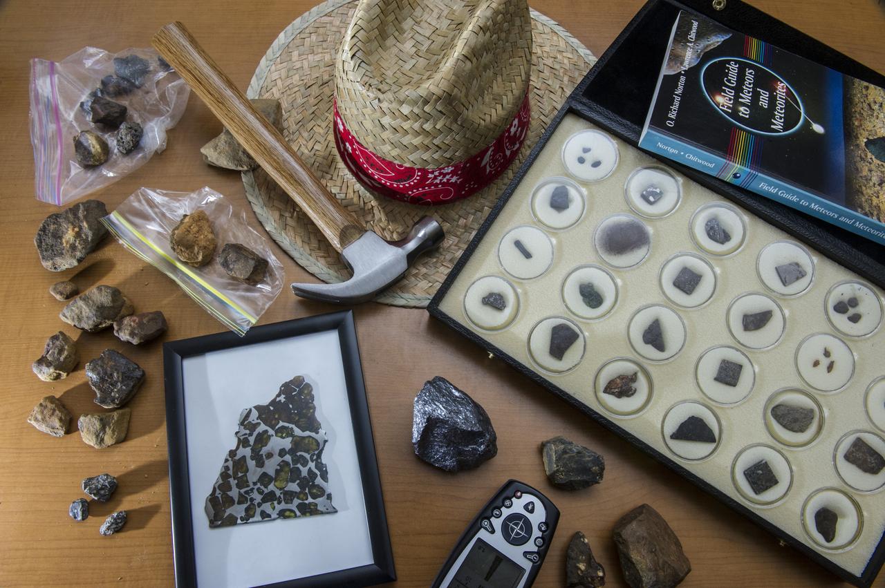
POSSIBLE METEORITE SAMPLES COLLECTED ON RECENT FIELD TRIP TO BANKHEAD NATIONAL FOREST, ALABAMA
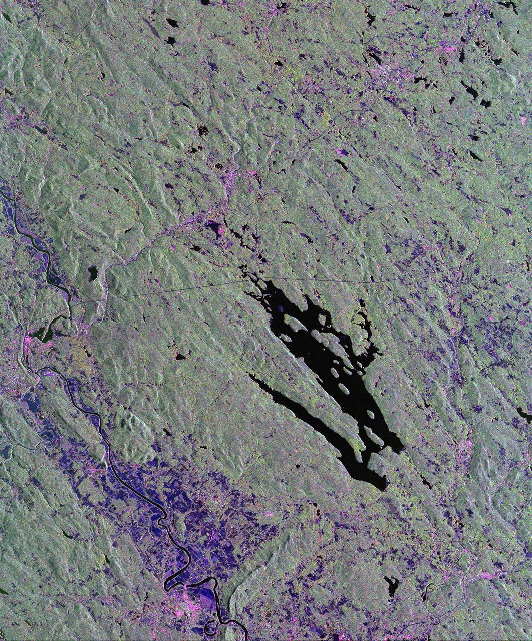
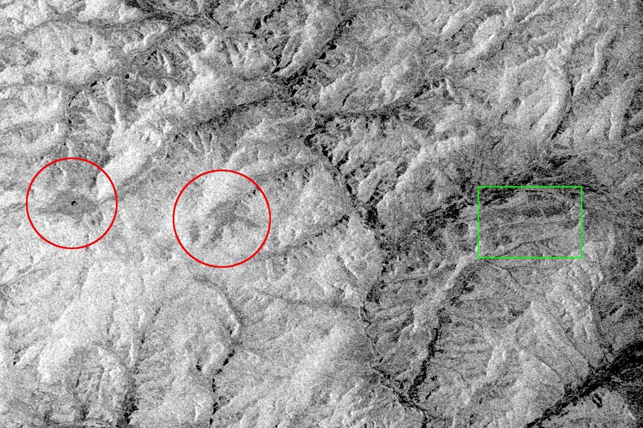
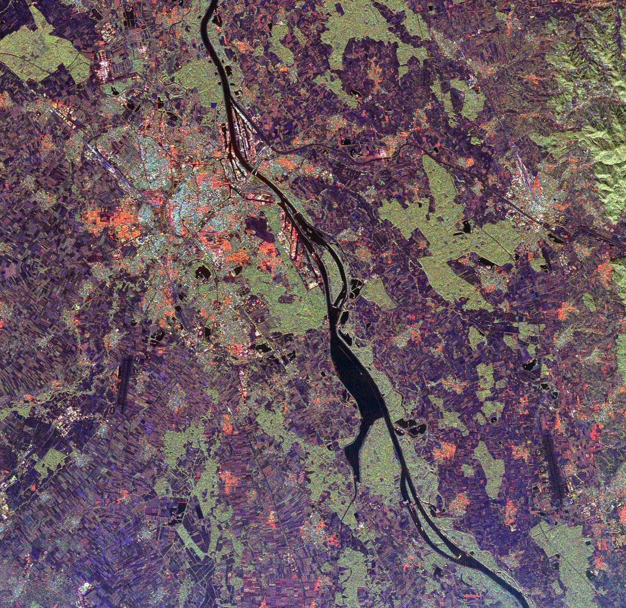
This is a radar image of the area surrounding the Harvard Forest in north-central Massachusetts that has been operated as a ecological research facility by Harvard University since 1907. At the center of the image is the Quabbin Reservoir, and the Connecticut River is at the lower left of the image. The Harvard Forest itself is just above the reservoir. Researchers are comparing the naturally occurring physical disturbances in the forest and the recent and projected chemical disturbances and their effects on the forest ecosystem. Agricultural land appears dark blue/purple, along with low shrub vegetation and some wetlands. Urban development is bright pink; the yellow to green tints are conifer-dominated vegetation with the pitch pine sand plain at the middle left edge of the image appearing very distinctive. The green tint may indicate pure pine plantation stands, and deciduous broadleaf trees appear gray/pink with perhaps wetter sites being pinker. This image was acquired by the Spaceborne Imaging Radar-C/X-Band Synthetic Aperture Radar (SIR-C/X-SAR) aboard the space shuttle Endeavour. SIR-C/X-SAR, a joint mission of the German, Italian and the United States space agencies, is part of NASA's Mission to Planet Earth. The image is centered at 42.50 degrees North latitude and 72.33 degrees West longitude and covers an area of 53 kilometers 63 by kilometers (33 miles by 39 miles). The colors in the image are assigned to different frequencies and polarizations of the radar as follows: red is L-band horizontally transmitted and horizontally received; green is L-band horizontally transmitted and vertically received; and blue is C-band horizontally transmitted and horizontally received. http://photojournal.jpl.nasa.gov/catalog/PIA01788
The Niepolmice Forest in Poland consists of six nature reserves, providing sanctuary for such threatened animals as lynx, wild cats and European Bison. Because of its proximity to Krakow, the old capital of Poland (left side of image), the forest (right side of image, dark red area) was a hunting ground for Polish Royalty beginning in the 13th century. The image was acquired May 25, 2003, covers an area of 29.5 by 48.5 km, and is located at 50 degrees north, 20.4 degrees east. With its 14 spectral bands from the visible to the thermal infrared wavelength region and its high spatial resolution of about 50 to 300 feet (15 to 90 meters), ASTER images Earth to map and monitor the changing surface of our planet. ASTER is one of five Earth-observing instruments launched Dec. 18, 1999, on Terra. The instrument was built by Japan's Ministry of Economy, Trade and Industry. A joint U.S./Japan science team is responsible for validation and calibration of the instrument and data products. The broad spectral coverage and high spectral resolution of ASTER provides scientists in numerous disciplines with critical information for surface mapping and monitoring of dynamic conditions and temporal change. Example applications are monitoring glacial advances and retreats; monitoring potentially active volcanoes; identifying crop stress; determining cloud morphology and physical properties; wetlands evaluation; thermal pollution monitoring; coral reef degradation; surface temperature mapping of soils and geology; and measuring surface heat balance. https://photojournal.jpl.nasa.gov/catalog/PIA23678
This 39 by 47 km ASTER sub-scene was acquired on May 20, 2000 and shows an area along the west side of the Cascade Range in west central Oregon. Bands 4, 3, and 2 were combined as red, green, and blue. In this composite, snow appears blue, forests are green, and clear-cut areas are orange-pink. The magnitude of logging operations is quite obvious, appearing as a checker board pattern. The image is centered at 44.6 degrees north latitude, 122.2 degrees west longitude. http://photojournal.jpl.nasa.gov/catalog/PIA11165
These ASTER images cover an area of 11 x 14 km on the north rim of the Grand Canyon, Arizona, and were acquired May 12, 2000. The left image displays bands 3,2,1 in RGB, displaying vegetation as red. The large dark area is burned forest, and small smoke plumes can be seen at the edges where active fires are burning. The right display substitutes SWIR band 8 for band 3. The bright red spots are the active fires, visible because the SWIR wavelength region has the capability to penetrate through the smoke. This image is located at 35.9 degrees north latitude and 113.4 degrees west longitude. http://photojournal.jpl.nasa.gov/catalog/PIA11092
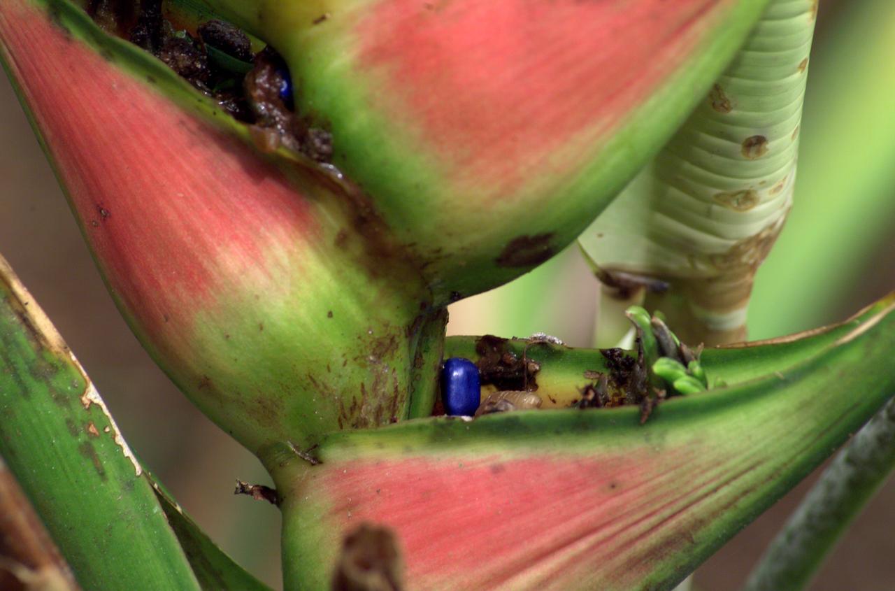
A plant photographed in the La Selva region of the Costa Rican rain forest as part of NASA's AirSAR 2004 Mesoamerica campaign. AirSAR 2004 Mesoamerica is a three-week expedition by an international team of scientists that will use an all-weather imaging tool, called the Airborne Synthetic Aperture Radar (AirSAR) which is located onboard NASA's DC-8 airborne laboratory. Scientists from many parts of the world including NASA's Jet Propulsion Laboratory are combining ground research done in several areas in Central America with NASA's AirSAR technology to improve and expand on the quality of research they are able to do. NASA's AIRSAR technolgy provides two essential elements to the ground-based scientists. First, it tests and provides accurate measurements of the forest structure. Secondly, AirSAR can study a larger area of the forest versus the smaller area that can be tested and plotted by the ground scientists. It also provides a unique one-of-a-kind system of measurement that obtains important information for the scientists, such as where forests are located and what exactly is in them.

A butterfly photographed in the La Selva region of the Costa Rican rain forest as part of NASA's AirSAR 2004 Mesoamerica campaign. AirSAR 2004 Mesoamerica is a three-week expedition by an international team of scientists that will use an all-weather imaging tool, called the Airborne Synthetic Aperture Radar (AirSAR) which is located onboard NASA's DC-8 airborne laboratory. Scientists from many parts of the world including NASA's Jet Propulsion Laboratory are combining ground research done in several areas in Central America with NASA's AirSAR technology to improve and expand on the quality of research they are able to do. NASA's AIRSAR technolgy provides two essential elements to the ground-based scientists. First, it tests and provides accurate measurements of the forest structure. Secondly, AirSAR can study a larger area of the forest versus the smaller area that can be tested and plotted by the ground scientists. It also provides a unique one-of-a-kind system of measurement that obtains important information for the scientists, such as where forests are located and what exactly is in them.
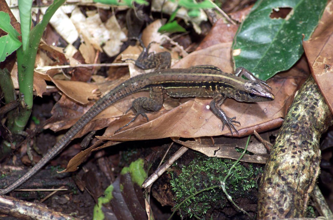
A lizard photographed in the La Selva region of the Costa Rican rain forest as part of NASA's AirSAR 2004 Mesoamerica campaign. AirSAR 2004 Mesoamerica is a three-week expedition by an international team of scientists that will use an all-weather imaging tool, called the Airborne Synthetic Aperture Radar (AirSAR) which is located onboard NASA's DC-8 airborne laboratory. Scientists from many parts of the world including NASA's Jet Propulsion Laboratory are combining ground research done in several areas in Central America with NASA's AirSAR technology to improve and expand on the quality of research they are able to do. NASA's AIRSAR technolgy provides two essential elements to the ground-based scientists. First, it tests and provides accurate measurements of the forest structure. Secondly, AirSAR can study a larger area of the forest versus the smaller area that can be tested and plotted by the ground scientists. It also provides a unique one-of-a-kind system of measurement that obtains important information for the scientists, such as where forests are located and what exactly is in them.
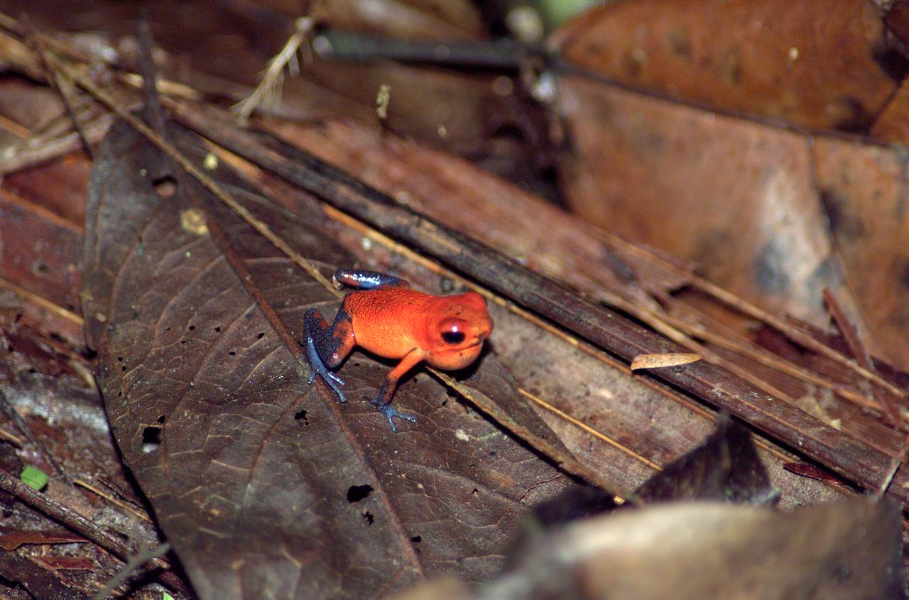
A tree frog photographed in the La Selva region of the Costa Rican rain forest as part of NASA's AirSAR 2004 Mesoamerica campaign. AirSAR 2004 Mesoamerica is a three-week expedition by an international team of scientists that will use an all-weather imaging tool, called the Airborne Synthetic Aperture Radar (AirSAR) which is located onboard NASA's DC-8 airborne laboratory. Scientists from many parts of the world including NASA's Jet Propulsion Laboratory are combining ground research done in several areas in Central America with NASA's AirSAR technology to improve and expand on the quality of research they are able to do. NASA's AIRSAR technolgy provides two essential elements to the ground-based scientists. First, it tests and provides accurate measurements of the forest structure. Secondly, AirSAR can study a larger area of the forest versus the smaller area that can be tested and plotted by the ground scientists. It also provides a unique one-of-a-kind system of measurement that obtains important information for the scientists, such as where forests are located and what exactly is in them.

JPL Uninhabited Aerial Vehicle Synthetic Aperture Radar collected this composite radar image around Québec City, Canada, during an 11-day campaign to study the structure of temperate and boreal forests.
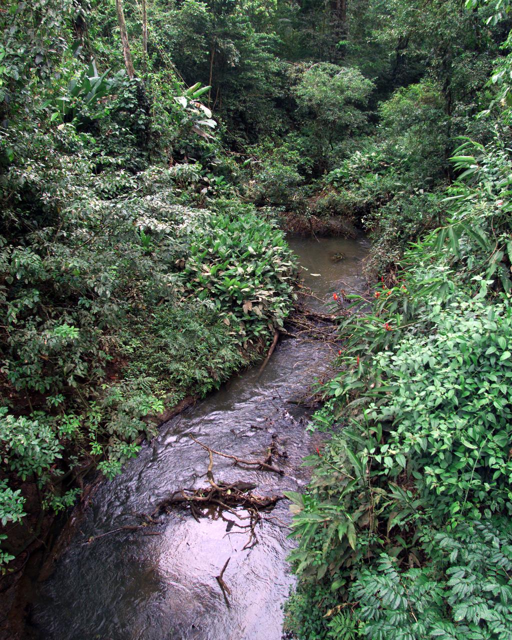
This photograph shows a stream in the La Selva region of the Costa Rican rain forest, taken during NASA's AirSAR 2004 Mesoamerica campaign. AirSAR 2004 Mesoamerica is a three-week expedition by an international team of scientists that will use an all-weather imaging tool, called the Airborne Synthetic Aperture Radar (AirSAR) which is located onboard NASA's DC-8 airborne laboratory. Scientists from many parts of the world including NASA's Jet Propulsion Laboratory are combining ground research done in several areas in Central America with NASA's AirSAR technology to improve and expand on the quality of research they are able to do. NASA's AIRSAR technolgy provides two essential elements to the ground-based scientists. First, it tests and provides accurate measurements of the forest structure. Secondly, AirSAR can study a larger area of the forest versus the smaller area that can be tested and plotted by the ground scientists. It also provides a unique one-of-a-kind system of measurement that obtains important information for the scientists, such as where forests are located and what exactly is in them.
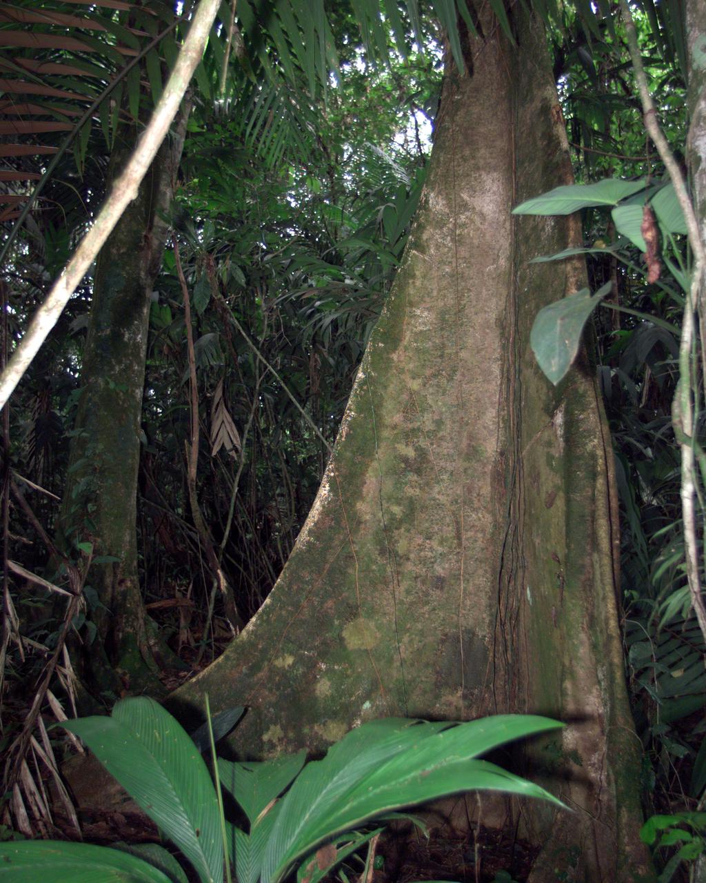
A unique tree trunk photographed in La Selva region of the Costa Rican rain forest as part of NASA's AirSAR 2004 Mesoamerica campaign. AirSAR 2004 Mesoamerica is a three-week expedition by an international team of scientists that will use an all-weather imaging tool, called the Airborne Synthetic Aperture Radar (AirSAR) which is located onboard NASA's DC-8 airborne laboratory. Scientists from many parts of the world including NASA's Jet Propulsion Laboratory are combining ground research done in several areas in Central America with NASA's AirSAR technology to improve and expand on the quality of research they are able to do. NASA's AIRSAR technolgy provides two essential elements to the ground-based scientists. First, it tests and provides accurate measurements of the forest structure. Secondly, AirSAR can study a larger area of the forest versus the smaller area that can be tested and plotted by the ground scientists. It also provides a unique one-of-a-kind system of measurement that obtains important information for the scientists, such as where forests are located and what exactly is in them.
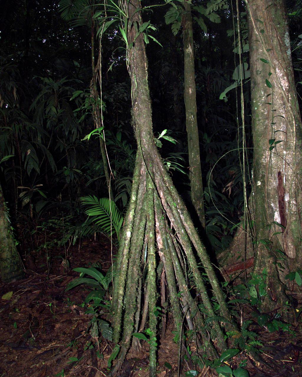
A tree trunk structure photographed in the La Selva region of the Costa Rican rain forest as part of NASA's AirSAR 2004 Mesoamerica campaign. AirSAR 2004 Mesoamerica is a three-week expedition by an international team of scientists that will use an all-weather imaging tool, called the Airborne Synthetic Aperture Radar (AirSAR) which is located onboard NASA's DC-8 airborne laboratory. Scientists from many parts of the world including NASA's Jet Propulsion Laboratory are combining ground research done in several areas in Central America with NASA's AirSAR technology to improve and expand on the quality of research they are able to do. NASA's AIRSAR technolgy provides two essential elements to the ground-based scientists. First, it tests and provides accurate measurements of the forest structure. Secondly, AirSAR can study a larger area of the forest versus the smaller area that can be tested and plotted by the ground scientists. It also provides a unique one-of-a-kind system of measurement that obtains important information for the scientists, such as where forests are located and what exactly is in them.
ISS028-E-010044 (27 June 2011) --- A crew member aboard the International Space Station, flying at an altitude of approximately 235 statute miles on June 27, 2011, exposed this still photograph of a major fire in the Jemez Mountains of the Santa Fe National Forest in north-central New Mexico. The fire is just southwest of Los Alamos National Laboratories.
ISS028-E-010043 (27 June 2011) --- A crew member aboard the International Space Station, flying at an altitude of approximately 235 statute miles on June 27, 2011, exposed this still photograph of a major fire in the Jemez Mountains of the Santa Fe National Forest in north-central New Mexico. The fire is just southwest of Los Alamos National Laboratories, which can be seen just right of center.

This is an image of equatorial Africa, centered on the equator at longitude 15degrees east. This image is a mosaic of almost 4,000 separate images obtained in 1996 by the L-band imaging radar onboard the Japanese Earth Resources Satellite. Using radar to penetrate the persistent clouds prevalent in tropical forests, the Japanese Earth Resources Satellite was able for the first time to image at high resolution this continental scale region during single flooding seasons. The area shown covers about 7.4 million square kilometers (2.8 million square miles) of land surface, spans more than 5,000 kilometers(3,100 miles) east and west and some 2,000 kilometers (1,240 miles) north and south. North is up in this image. At the full resolution of the mosaic (100 meters or 330 feet), this image is more than 500 megabytes in size, and was processed from imagery totaling more than 60 gigabytes. Central Africa was imaged twice in 1996, once between January and March, which is the major low-flood season in the Congo Basin, and once between October and November, which is the major high-flood season in the Congo Basin. The red color corresponds to the data from the low-flood season, the green to the high-flood season, and the blue to the "texture" of the low-flood data. The forests appear green as a result, the flooded and palm forests, as well as urban areas, appear yellow, the ocean and lakes appear black, and savanna areas appear blue, black or green, depending on the savanna type, surface topography and other factors. The areas of the image that are black and white were mapped only between January and March 1996. In these areas, the black areas are savanna or open water, the gray are forests, and the white areas are flooded forests or urban areas. The Congo River dominates the middle of the image, where the nearby forests that are periodically flooded by the Congo and its tributaries stand out as yellow. The Nile River flows north from Lake Victoria in the middle right of the color portion of the mosaic. http://photojournal.jpl.nasa.gov/catalog/PIA01348
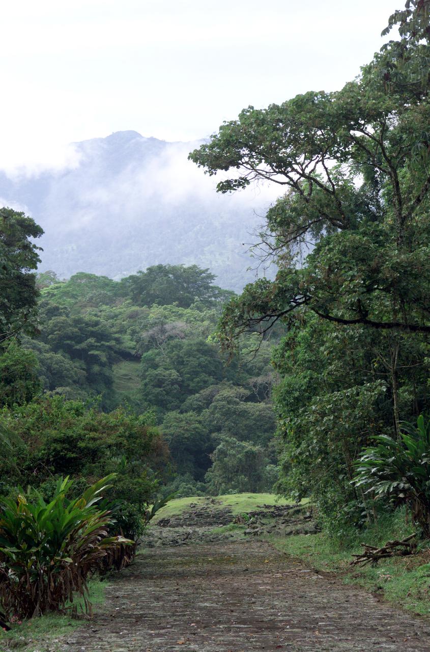
Dense rain forest in the La Selva region of Costa Rica. AirSAR 2004 Mesoamerica is a three-week expedition by an international team of scientists that uses an all-weather imaging tool, called the Airborne Synthetic Aperture Radar (AirSAR) which is located onboard NASA's DC-8 airborne laboratory. Scientists from many parts of the world including NASA's Jet Propulsion Laboratory are combining ground research done in several areas in Central America with NASA's AirSAR technology to improve and expand on the quality of research they are able to conduct. The radar, developed by NASA's Jet Propulsion Laboratory, can penetrate clouds and also collect data at night. Its high-resolution sensors operate at multiple wavelengths and modes, allowing AirSAR to see beneath treetops, through thin sand, and dry snow pack. AirSAR's 2004 campaign is a collaboration of many U.S. and Central American institutions and scientists, including NASA; the National Science Foundation; the Smithsonian Institution; National Geographic; Conservation International; the Organization of Tropical Studies; the Central American Commission for Environment and Development; and the Inter-American Development Bank.

NASA’s B200 King Air aircraft – based at NASA’s Armstrong Flight Research Center in Edwards, California – ascends to support a prescribed burn in Geneva State Forest, about 100 miles south of Montgomery, Alabama, on March 17, 2025. The effort is part of NASA’s multi-year FireSense project, which aims to test technology that predicts fire and smoke behavior. This data could eventually benefit the U.S. Forest Service as well as local, state, and other federal wildland fire agencies.

iss073e0433580 (June 27, 2025) --- Atlanta, Georgia, also known as the "City in a Forest" almost half covered by trees, and home to the busiest airport in the world, Hartsfield-Jackson Atlanta International Airport (center left), is pictured at approximately 6:19 a.m. local time from the International Space Station as it orbited 260 miles above the southern United States.
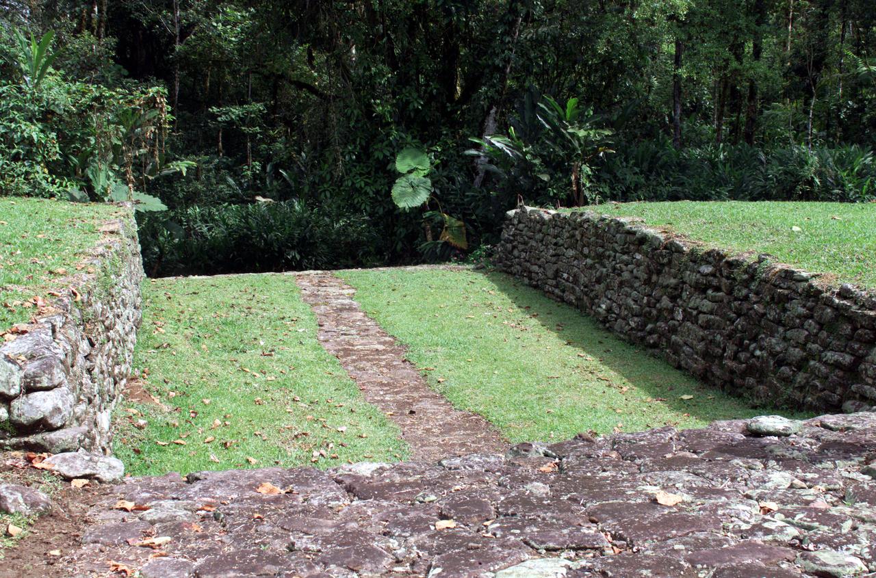
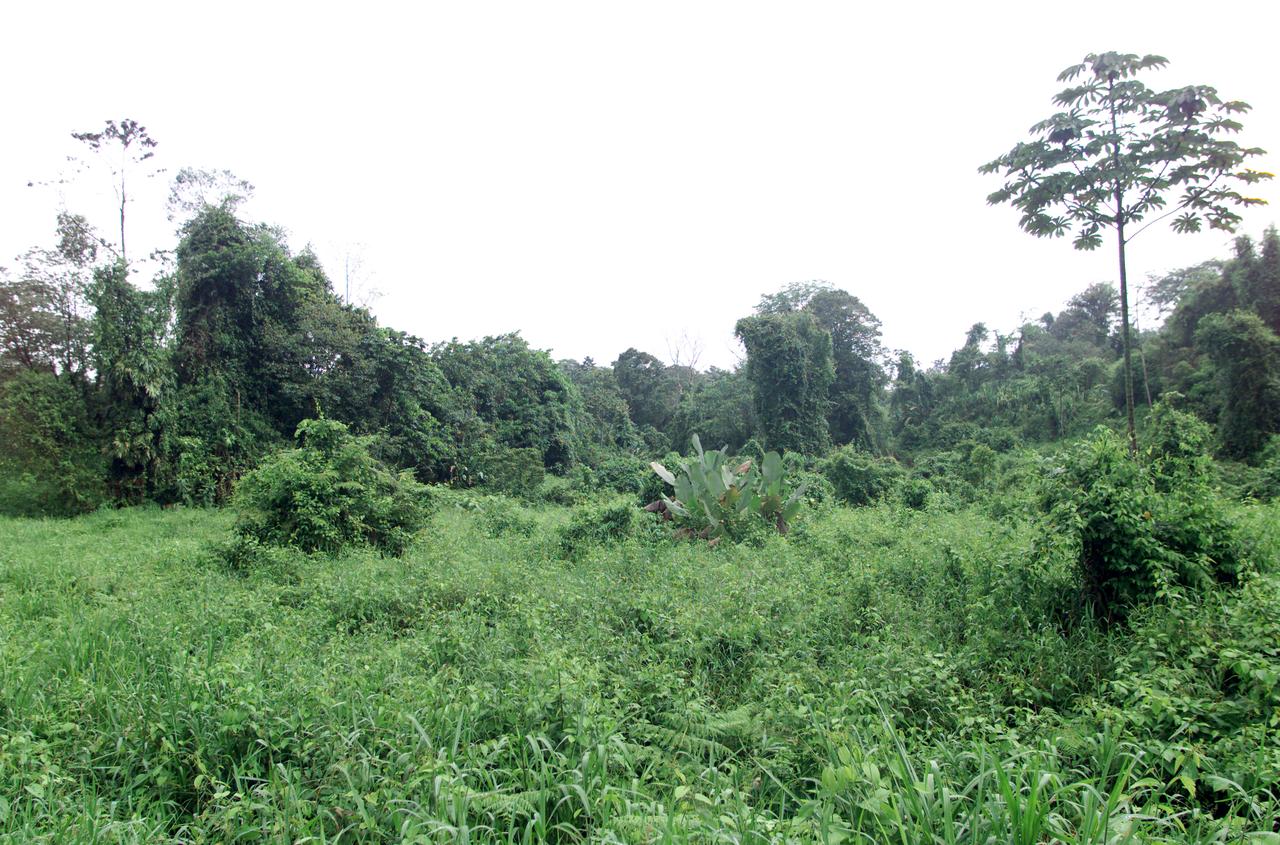
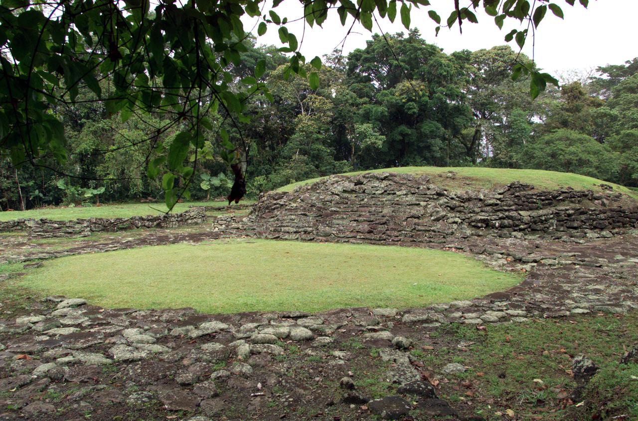
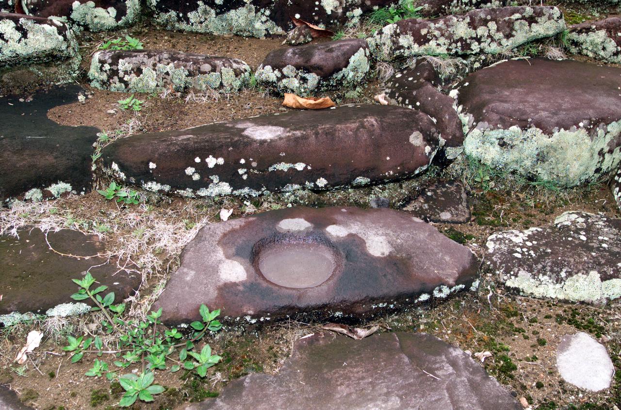
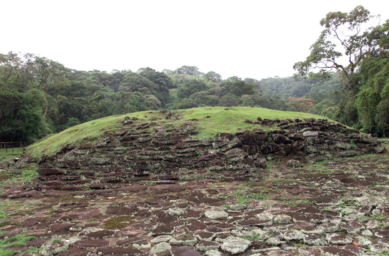
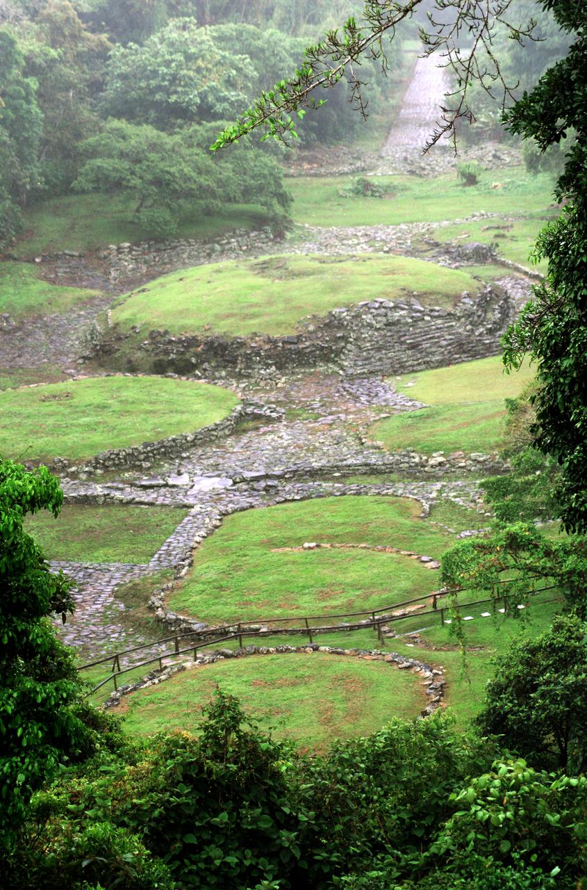
Pre-Columbian archaeological ruins are revealed through Costa Rican rain forest in this photo taken during NASA's AirSAR 2004 Mesoamerica campaign. AirSAR 2004 Mesoamerica is a three-week expedition by an international team of scientists that uses an all-weather imaging tool, called the Airborne Synthetic Aperture Radar (AirSAR) which is located onboard NASA's DC-8 airborne laboratory. The radar, developed by NASA's Jet Propulsion Laboratory, can penetrate clouds and also collect data at night. Its high-resolution sensors operate at multiple wavelengths and modes, allowing AirSAR to see beneath treetops, through thin sand, and dry snow pack. Much of the archaeological evidence needed to understand Pre-Columbian societies in Central America comes from features on the landscape. Difficult terrain and logistics have limited ground data collection. AirSAR helped to detect signs of ancient civilizations hidden beneath the forest. Its images will shed insights into the way modern humans interact with their landscape, and how ancient peoples lived and what became of their civilizations.
Pre-Columbian archaeological ruins are revealed through Costa Rican rain forest in this photo taken during NASA's AirSAR 2004 Mesoamerica campaign. AirSAR 2004 Mesoamerica is a three-week expedition by an international team of scientists that uses an all-weather imaging tool, called the Airborne Synthetic Aperture Radar (AirSAR) which is located onboard NASA's DC-8 airborne laboratory. The radar, developed by NASA's Jet Propulsion Laboratory, can penetrate clouds and also collect data at night. Its high-resolution sensors operate at multiple wavelengths and modes, allowing AirSAR to see beneath treetops, through thin sand, and dry snow pack. Much of the archaeological evidence needed to understand Pre-Columbian societies in Central America comes from features on the landscape. Difficult terrain and logistics have limited ground data collection. AirSAR helped to detect signs of ancient civilizations hidden beneath the forest. Its images will shed insights into the way modern humans interact with their landscape, and how ancient peoples lived and what became of their civilizations.
Pre-Columbian archaeological ruins are revealed through Costa Rican rain forest in this photo taken during NASA's AirSAR 2004 Mesoamerica campaign. AirSAR 2004 Mesoamerica is a three-week expedition by an international team of scientists that uses an all-weather imaging tool, called the Airborne Synthetic Aperture Radar (AirSAR) which is located onboard NASA's DC-8 airborne laboratory. The radar, developed by NASA's Jet Propulsion Laboratory, can penetrate clouds and also collect data at night. Its high-resolution sensors operate at multiple wavelengths and modes, allowing AirSAR to see beneath treetops, through thin sand, and dry snow pack. Much of the archaeological evidence needed to understand Pre-Columbian societies in Central America comes from features on the landscape. Difficult terrain and logistics have limited ground data collection. AirSAR helped to detect signs of ancient civilizations hidden beneath the forest. Its images will shed insights into the way modern humans interact with their landscape, and how ancient peoples lived and what became of their civilizations.
Pre-Columbian archaeological ruins are revealed through Costa Rican rain forest in this photo taken during NASA's AirSAR 2004 Mesoamerica campaign. AirSAR 2004 Mesoamerica is a three-week expedition by an international team of scientists that uses an all-weather imaging tool, called the Airborne Synthetic Aperture Radar (AirSAR) which is located onboard NASA's DC-8 airborne laboratory. The radar, developed by NASA's Jet Propulsion Laboratory, can penetrate clouds and also collect data at night. Its high-resolution sensors operate at multiple wavelengths and modes, allowing AirSAR to see beneath treetops, through thin sand, and dry snow pack. Much of the archaeological evidence needed to understand Pre-Columbian societies in Central America comes from features on the landscape. Difficult terrain and logistics have limited ground data collection. AirSAR helped to detect signs of ancient civilizations hidden beneath the forest. Its images will shed insights into the way modern humans interact with their landscape, and how ancient peoples lived and what became of their civilizations.
Pre-Columbian archaeological ruins are revealed through Costa Rican rain forest in this photo taken during NASA's AirSAR 2004 Mesoamerica campaign. AirSAR 2004 Mesoamerica is a three-week expedition by an international team of scientists that uses an all-weather imaging tool, called the Airborne Synthetic Aperture Radar (AirSAR) which is located onboard NASA's DC-8 airborne laboratory. The radar, developed by NASA's Jet Propulsion Laboratory, can penetrate clouds and also collect data at night. Its high-resolution sensors operate at multiple wavelengths and modes, allowing AirSAR to see beneath treetops, through thin sand, and dry snow pack. Much of the archaeological evidence needed to understand Pre-Columbian societies in Central America comes from features on the landscape. Difficult terrain and logistics have limited ground data collection. AirSAR helped to detect signs of ancient civilizations hidden beneath the forest. Its images will shed insights into the way modern humans interact with their landscape, and how ancient peoples lived and what became of their civilizations.
Pre-Columbian archaeological ruins are revealed through Costa Rican rain forest in this photo taken during NASA's AirSAR 2004 Mesoamerica campaign. AirSAR 2004 Mesoamerica is a three-week expedition by an international team of scientists that uses an all-weather imaging tool, called the Airborne Synthetic Aperture Radar (AirSAR) which is located onboard NASA's DC-8 airborne laboratory. The radar, developed by NASA's Jet Propulsion Laboratory, can penetrate clouds and also collect data at night. Its high-resolution sensors operate at multiple wavelengths and modes, allowing AirSAR to see beneath treetops, through thin sand, and dry snow pack. Much of the archaeological evidence needed to understand Pre-Columbian societies in Central America comes from features on the landscape. Difficult terrain and logistics have limited ground data collection. AirSAR helped to detect signs of ancient civilizations hidden beneath the forest. Its images will shed insights into the way modern humans interact with their landscape, and how ancient peoples lived and what became of their civilizations.
The Hayman forest fire, started on June 8, is continuing to burn in the Pike National Forest, 57 km (35 miles) south-southwest of Denver. According to the U.S. Forest Service, the fire has consumed more than 90,000 acres and has become Colorado's worst fire ever. In this ASTER image, acquired Sunday, June 16, 2002 at 10:30 am MST, the dark blue area is burned vegetation and the green areas are healthy vegetation. Red areas are active fires, and the blue cloud at the top center is smoke. Meteorological clouds are white. The image covers an area of 32.2 x 35.2 km (20.0 x 21.8 miles), and displays ASTER bands 8-3-2 in red, green and blue. http://photojournal.jpl.nasa.gov/catalog/PIA03499

A spider photographed during NASA's AirSAR 2004 Mesoamerica campaign in the La Selva region of the Costa Rican rain forest. AirSAR 2004 Mesoamerica is a three-week expedition by an international team of scientists that uses an all-weather imaging tool, called the Airborne Synthetic Aperture Radar (AirSAR) which is located onboard NASA's DC-8 airborne laboratory. Scientists from many parts of the world including NASA's Jet Propulsion Laboratory are combining ground research done in several areas in Central America with NASA's AirSAR technology to improve and expand on the quality of research they are able to conduct. The radar, developed by NASA's Jet Propulsion Laboratory, can penetrate clouds and also collect data at night. Its high-resolution sensors operate at multiple wavelengths and modes, allowing AirSAR to see beneath treetops, through thin sand, and dry snow pack. AirSAR's 2004 campaign is a collaboration of many U.S. and Central American institutions and scientists, including NASA; the National Science Foundation; the Smithsonian Institution; National Geographic; Conservation International; the Organization of Tropical Studies; the Central American Commission for Environment and Development; and the Inter-American Development Bank.
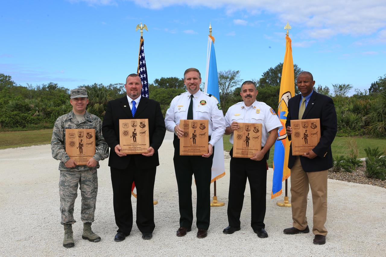
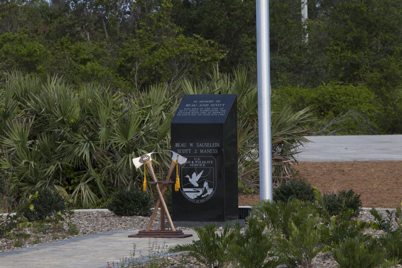
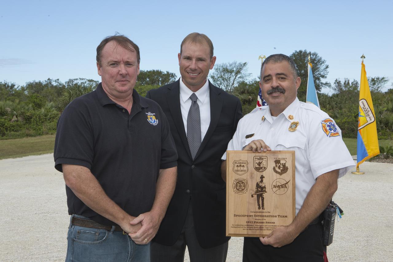
From left, Jon Wallace, deputy fire coordinator, U.S. Fish and Wildlife Service Southeast Region, Atlanta, Georgia; Chris Wilcox, U.S. Fish and Wildlife chief, Fire Management, National Interagency Fire Center, Boise, Idaho; and John Fish, chief, Florida Forest Service, pose for a portrait following a ceremony Nov. 1 on the Merritt Island National Wildlife Refuge in Florida. During the joint ceremony, the Spaceport Integration Team and its partners were presented with the prestigious 2017 Pulaski Award and a new memorial marker was dedicated. The multi-agency team includes representatives from NASA's Kennedy Space Center, Cape Canaveral Air Force Station's 45th Space Wing, the Merritt Island National Wildlife Refuge, as well as the Florida Forest Service and Brevard County Fire Rescue. The memorial marker honors two fallen firefighters, Scott Maness and Beau Sauselein, who died fighting a wildfire on space center property in 1981. Held outdoors, the ceremony was attended by 140 guests.
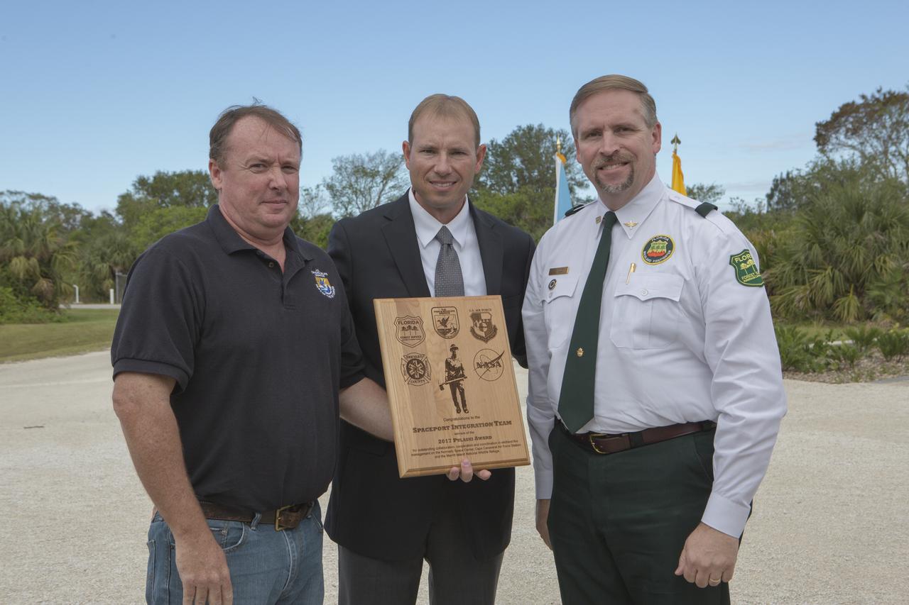
From left, Col. Z. Walter Jackim, vice commander, 45th Space Wing, Cape Canaveral Air Force Station; Michael Good, assistant fire management officer, Merritt Island National Wildlife Refuge; John Fish, chief, Florida Forest Service; Mark Schollmeyer, chief, Brevard County Fire Rescue; and Kelvin Manning, associate director, NASA's Kennedy Space Center, pose for a portrait following a ceremony Nov. 1 on the Merritt Island National Wildlife Refuge in Florida. During the joint ceremony, the Spaceport Integration Team and its partners were presented with the prestigious 2017 Pulaski Award and a new memorial marker was dedicated. The multi-agency team includes representatives from NASA's Kennedy Space Center, Cape Canaveral Air Force Station's 45th Space Wing, the Merritt Island National Wildlife Refuge, as well as the Florida Forest Service and Brevard County Fire Rescue. The memorial marker honors two fallen firefighters, Scott Maness and Beau Sauselein, who died fighting a wildfire on space center property in 1981. Held outdoors, the ceremony was attended by 140 guests.

STS043-151-159 (2-11 August 1991) --- This photograph looks westward over the high plateau of the southern Peruvian Andes west and north of Lake Titicaca (not in field of view). Lima, Peru lies under the clouds just north of the clear coastal area. Because the high Andes have been uplifted 10,000 to 13,000 feet during the past 20 million years, the rivers which cut down to the Pacific Ocean have gorges almost that deep, such as the Rio Ocona at the bottom of the photograph. The eastern slopes of the Andes are heavily forested, forming the headwaters of the Amazon system. Smoke from burning in the Amazon basin fills river valleys on the right side of the photograph. A Linhof camera was used to take this view.
STS049-91-079 (7 - 16 May 1992) --- This 70mm frame, photographed from the Earth-orbiting Space Shuttle Endeavour, features a dendritic drainage pattern in Zaire. Cleared pasture land shows light green in this color photograph, in contrast to the dark, closed-canopy forest of Zaire. Remnant woodland along minor streams indicates the intricate drainage network of this hilly region. Scattered vegetation-free spots show the deep red, tropical soil of the region. The sediment-laden stream is the Vele River just west of the village of Niangara. A crew member used a 70mm handheld Hasselblad camera with a 250mm lens to record the image.
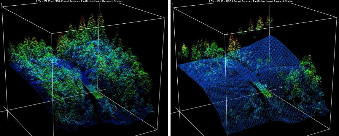
New maps of two recent California megafires that combine unique data sets from the U.S. Forest Service and NASA's Jet Propulsion Laboratory in Pasadena, California, are answering some of the urgent questions that follow a huge wildfire. These before-and-after USFS LIght Detection And Ranging (LIDAR) images from the 2014 King fire region in El Dorado National Forest, California are among new maps. They show a small section of the Rubicon River drainage basin, where fire damage was severe. Blue indicates ground level; lighter colors are higher. A road -- bordered by dense trees in the before image at left -- and part of a bridge are in the center, with the bridge appearing green. http://photojournal.jpl.nasa.gov/catalog/PIA19360
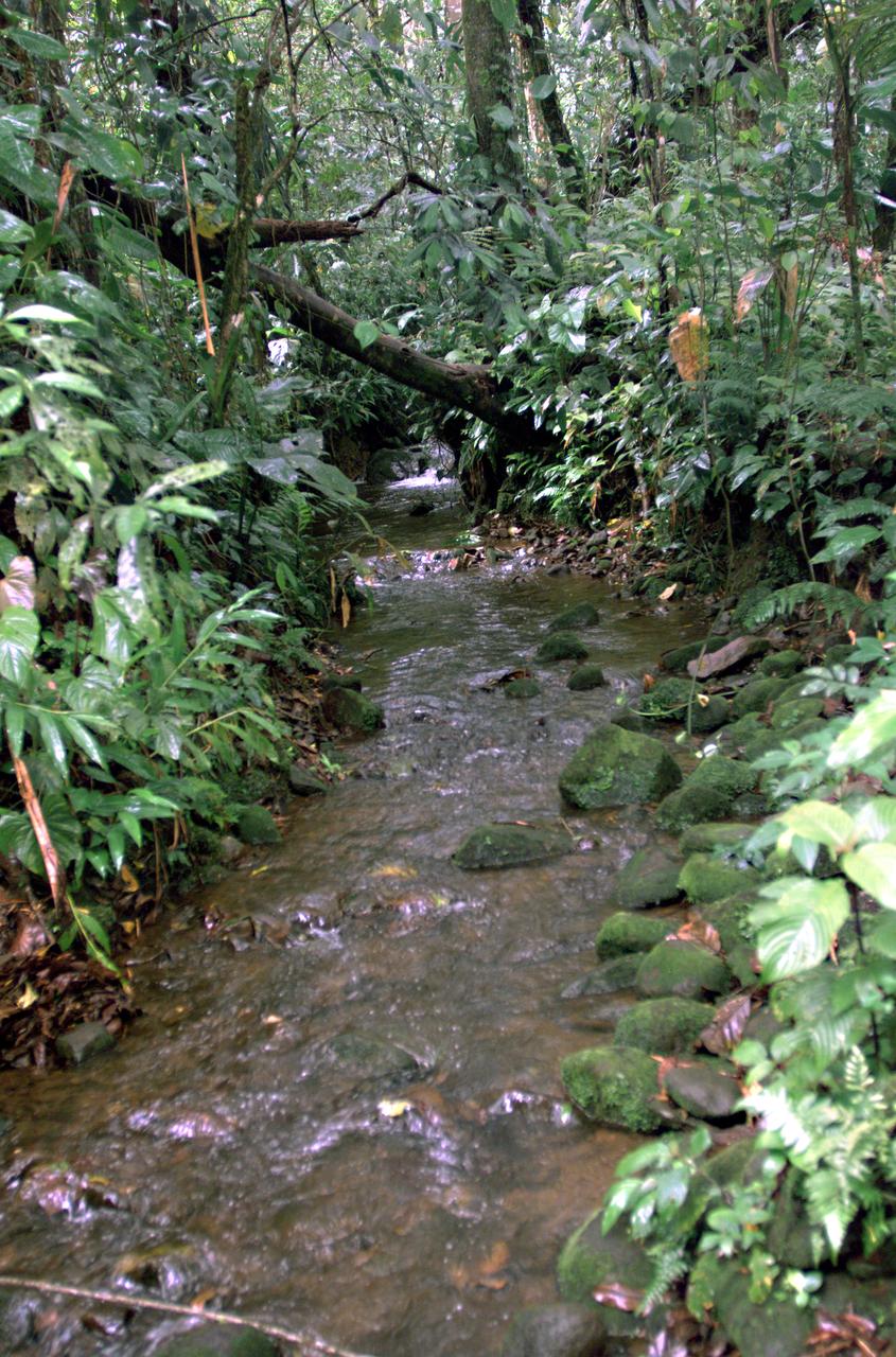
This photograph shows a stream in the La Selva region of the Costa Rican rain forest, taken during NASA's AirSAR 2004 campaign. AirSAR 2004 Mesoamerica is a three-week expedition by an international team of scientists that uses an all-weather imaging tool, called the Airborne Synthetic Aperture Radar (AirSAR) which is located onboard NASA's DC-8 airborne laboratory. Scientists from many parts of the world including NASA's Jet Propulsion Laboratory are combining ground research done in several areas in Central America with NASA's AirSAR technology to improve and expand on the quality of research they are able to conduct. The radar, developed by NASA's Jet Propulsion Laboratory, can penetrate clouds and also collect data at night. Its high-resolution sensors operate at multiple wavelengths and modes, allowing AirSAR to see beneath treetops, through thin sand, and dry snow pack. AirSAR's 2004 campaign is a collaboration of many U.S. and Central American institutions and scientists, including NASA; the National Science Foundation; the Smithsonian Institution; National Geographic; Conservation International; the Organization of Tropical Studies; the Central American Commission for Environment and Development; and the Inter-American Development Bank.
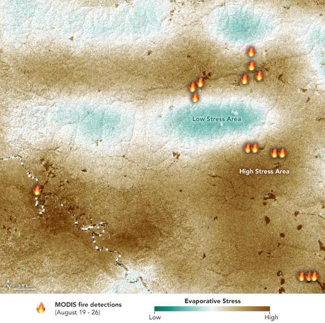
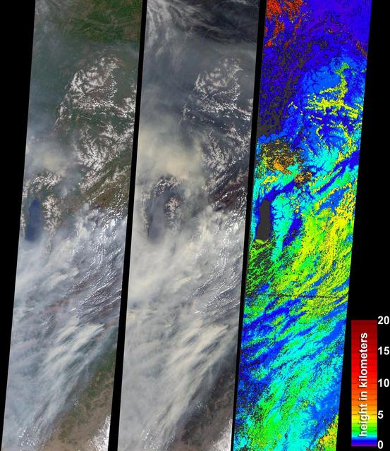
NASA's ECOsystem Spaceborne Thermal Radiometer Experiment on Space Station (ECOSTRESS) sensor measured the water-stress levels of plants when it passed over the Peruvian Amazon rainforest on Aug. 7, 2019, before the fires there began. The map shows areas of plants in distress (brown) and areas of less stress (blue). Water-stressed plants released measurably less water vapor into the air at the time of the summer fires. The fire icons represent fires imaged by NASA's Terra satellite between Aug. 19 and 26. The burn pattern reveals that the fires were concentrated in areas of highly water-stressed plants, pointing to how water-stressed plants can impact the spread of fires. The data may one day help NASA's Earth-observing missions predict the path of future forest or brush fires. https://photojournal.jpl.nasa.gov/catalog/PIA23432
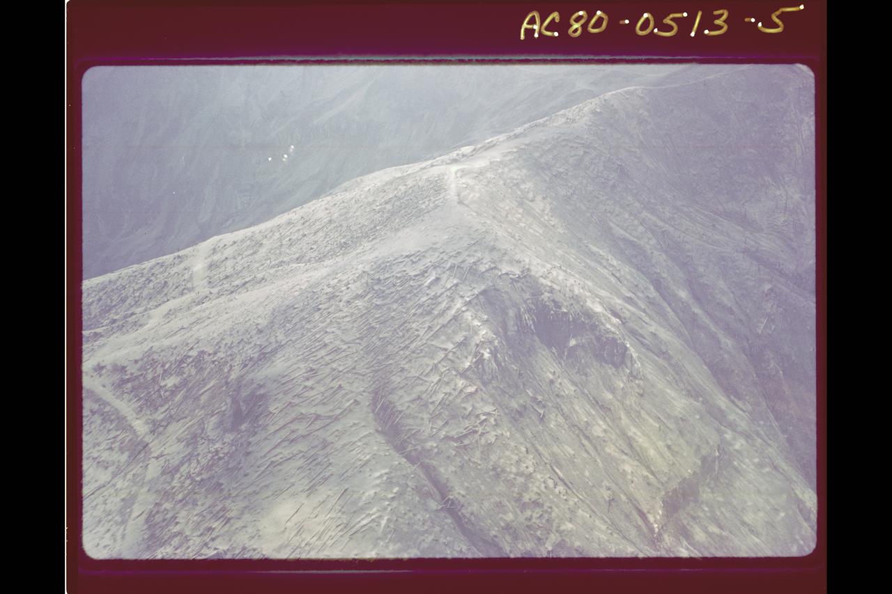
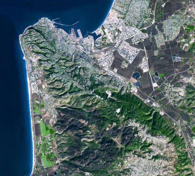
Prominently displayed in this image, Mt. Pinos, at 2,692 meters 8,831 feet is the highest peak in the Los Padres National Forest.
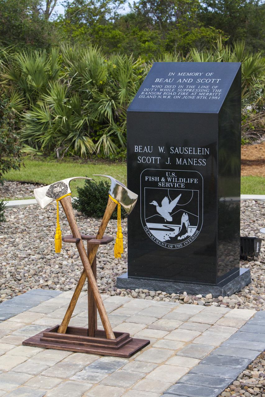
Ceremonial Pulaski tools are positioned in front of a new memorial marker Nov. 1 on the Merritt Island National Wildlife Refuge in Florida. During a joint ceremony, the Spaceport Integration Team and its partners were presented with the prestigious 2017 Pulaski Award and the new memorial marker was dedicated. The multi-agency team includes representatives from NASA's Kennedy Space Center, Cape Canaveral Air Force Station's 45th Space Wing, the Merritt Island National Wildlife Refuge, as well as the Florida Forest Service and Brevard County Fire Rescue. The memorial marker honors two fallen firefighters, Scott Maness and Beau Sauselein, who died fighting a wildfire on space center property in 1981. Held outdoors, the ceremony was attended by 140 guests.

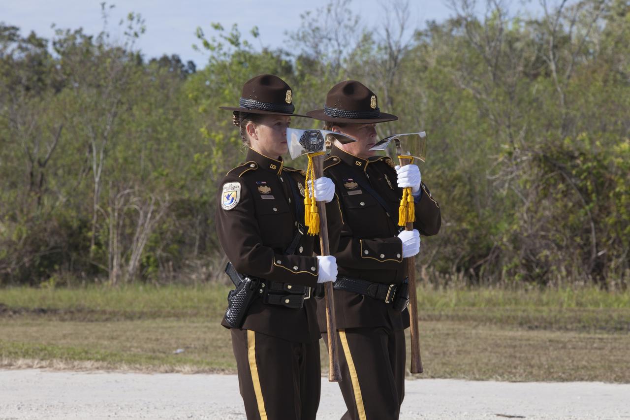
A presentation of colors by the U.S. Fish and Wildlife Service honor guard opened a ceremony Nov. 1 on the Merritt Island National Wildlife Refuge in Florida. During the joint ceremony, the Spaceport Integration Team and its partners were presented with the prestigious 2017 Pulaski Award and the new memorial marker was dedicated. The multi-agency team includes representatives from NASA's Kennedy Space Center, Cape Canaveral Air Force Station's 45th Space Wing, the Merritt Island National Wildlife Refuge, as well as the Florida Forest Service and Brevard County Fire Rescue. The memorial marker honors two fallen firefighters, Scott Maness and Beau Sauselein, who died fighting a wildfire on space center property in 1981. Held outdoors, the ceremony was attended by 140 guests.
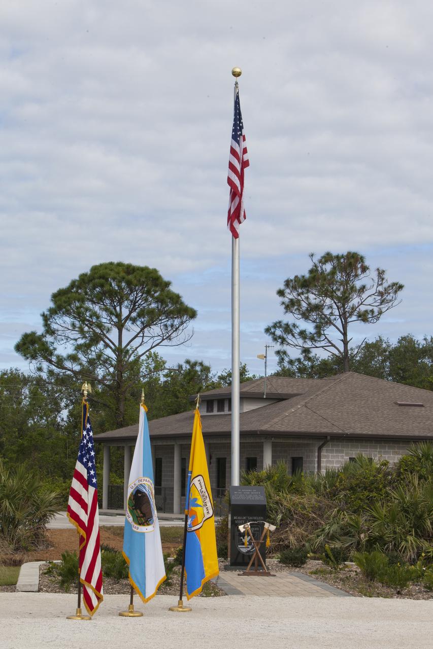
A presentation of colors opened a ceremony Nov. 1 on the Merritt Island National Wildlife Refuge in Florida. During the joint ceremony, the Spaceport Integration Team and its partners were presented with the prestigious 2017 Pulaski Award and a new memorial marker was dedicated. The multi-agency team includes representatives from NASA's Kennedy Space Center, Cape Canaveral Air Force Station's 45th Space Wing, the Merritt Island National Wildlife Refuge, as well as the Florida Forest Service and Brevard County Fire Rescue. The memorial marker honors two fallen firefighters, Scott Maness and Beau Sauselein, who died fighting a wildfire on space center property in 1981. Held outdoors, the ceremony was attended by 140 guests.
Firefighters prepare to place ceremonial Pulaski tools by a new memorial marker Nov. 1 on the Merritt Island National Wildlife Refuge in Florida. During a joint ceremony, the Spaceport Integration Team and its partners were presented with the prestigious 2017 Pulaski Award and the new memorial marker was dedicated. The multi-agency team includes representatives from NASA's Kennedy Space Center, Cape Canaveral Air Force Station's 45th Space Wing, the Merritt Island National Wildlife Refuge, as well as the Florida Forest Service and Brevard County Fire Rescue. The memorial marker honors two fallen firefighters, Scott Maness and Beau Sauselein, who died fighting a wildfire on space center property in 1981. Held outdoors, the ceremony was attended by 140 guests.
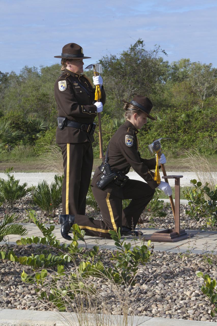
Firefighters place ceremonial Pulaski tools by a new memorial marker Nov. 1 on the Merritt Island National Wildlife Refuge in Florida. During a joint ceremony, the Spaceport Integration Team and its partners were presented with the prestigious 2017 Pulaski Award and the new memorial marker was dedicated. The multi-agency team includes representatives from NASA's Kennedy Space Center, Cape Canaveral Air Force Station's 45th Space Wing, the Merritt Island National Wildlife Refuge, as well as the Florida Forest Service and Brevard County Fire Rescue. The memorial marker honors two fallen firefighters, Scott Maness and Beau Sauselein, who died fighting a wildfire on space center property in 1981. Held outdoors, the ceremony was attended by 140 guests.
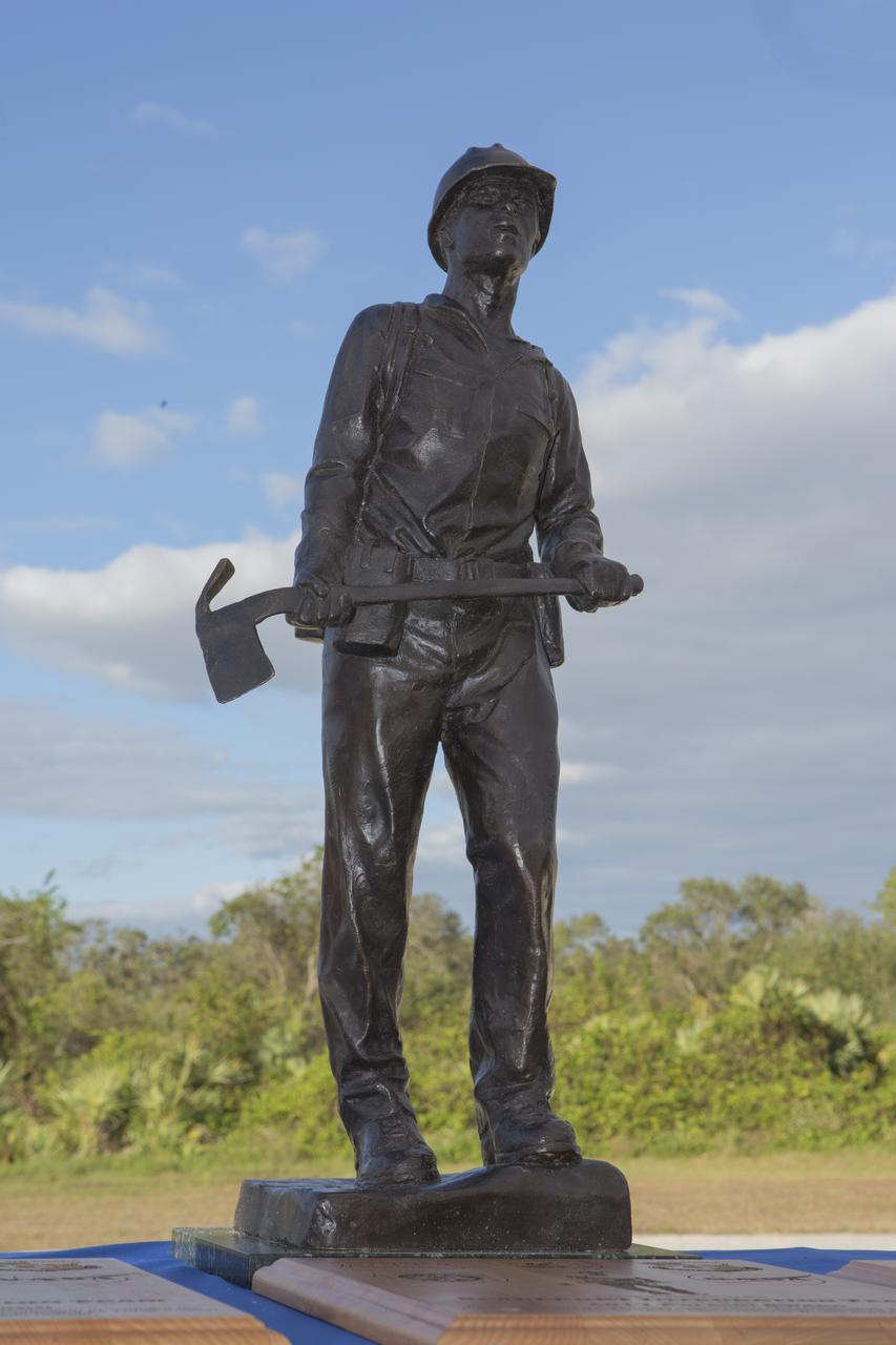
The prestigious 2017 Pulaski Award is on display near a new memorial marker on the Merritt Island National Wildlife Refuge in Florida. During a joint ceremony, the Spaceport Integration Team and its partners were presented with the award and a new memorial marker was dedicated. The multi-agency team includes representatives from NASA's Kennedy Space Center, Cape Canaveral Air Force Station's 45th Space Wing, the Merritt Island National Wildlife Refuge, as well as the Florida Forest Service and Brevard County Fire Rescue. The memorial marker honors two fallen firefighters, Scott Maness and Beau Sauselein, who died fighting a wildfire on space center property in 1981. Held outdoors, the ceremony was attended by 140 guests.
Ceremonial Pulaski tools are positioned in front of a new memorial marker Nov. 1 on the Merritt Island National Wildlife Refuge in Florida. During a joint ceremony, the Spaceport Integration Team and its partners were presented with the prestigious 2017 Pulaski Award and the new memorial marker was dedicated. The multi-agency team includes representatives from NASA's Kennedy Space Center, Cape Canaveral Air Force Station's 45th Space Wing, the Merritt Island National Wildlife Refuge, as well as the Florida Forest Service and Brevard County Fire Rescue. The memorial marker honors two fallen firefighters, Scott Maness and Beau Sauselein, who died fighting a wildfire on space center property in 1981. Held outdoors, the ceremony was attended by 140 guests.
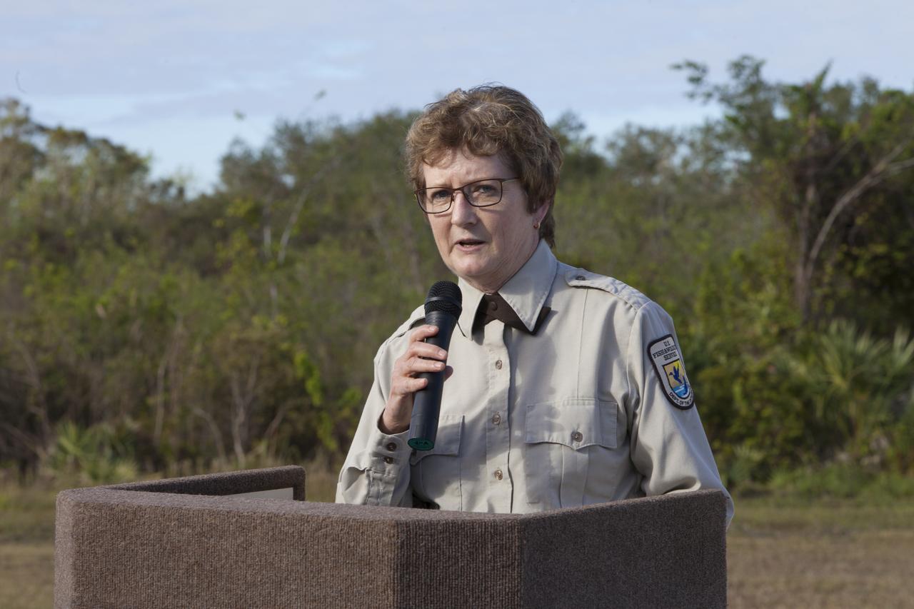
Layne Hamilton, manager of the Merritt Island National Wildlife Refuge, welcomes guests to a ceremony held Nov. 1 on the refuge in Florida. During the joint ceremony, the Spaceport Integration Team and its partners were presented with the prestigious 2017 Pulaski Award and a new memorial marker was dedicated. The multi-agency team includes representatives from NASA's Kennedy Space Center, Cape Canaveral Air Force Station's 45th Space Wing, the Merritt Island National Wildlife Refuge, as well as the Florida Forest Service and Brevard County Fire Rescue. The memorial marker honors two fallen firefighters, Scott Maness and Beau Sauselein, who died fighting a wildfire on space center property in 1981. Held outdoors, the ceremony was attended by 140 guests.
The city of Sapporo on the northernmost of the Japanese Home Island of Hokkaido (43.5N, 141.5E), host to the 1986 Winter Olympic Games is situated along the margin of a large valley which extends across the island from the Sea of Japan to the Pacific Ocean. The Valley is largely cultivated (the lighter green of the cultivated land distinguishes it from the gray urban development of Sapporo), but much of the island remains heavily forested.
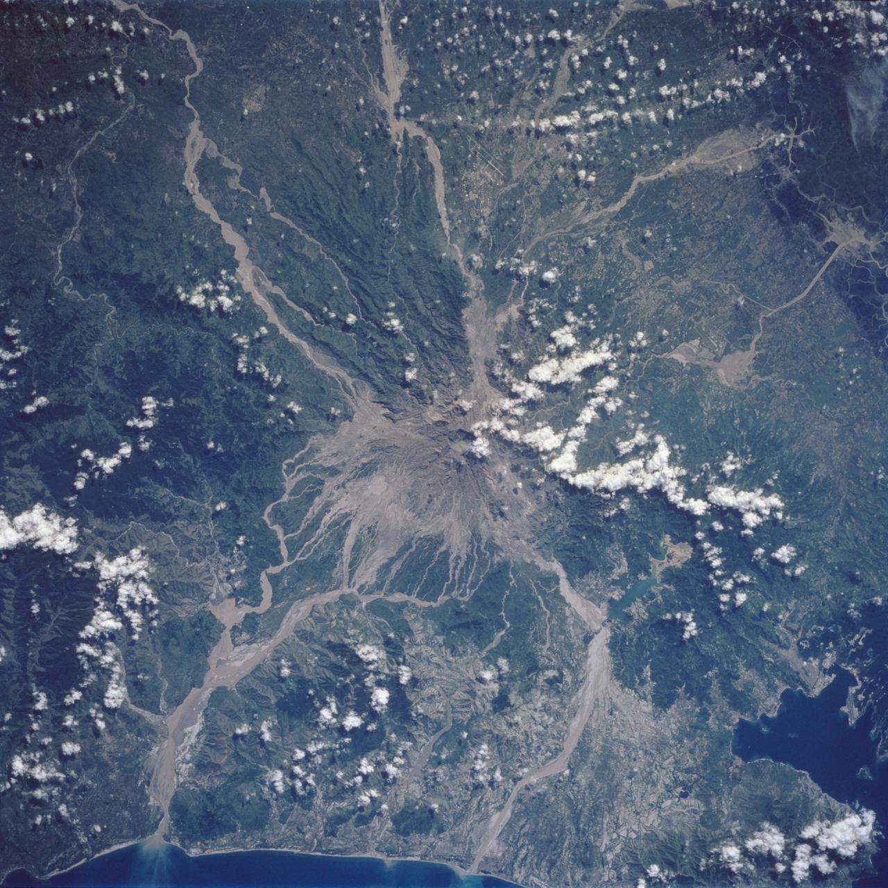
Mt. Pinatubo on the island of Luzon (15.0N, 120.0E) erupted catastrophically in June 1991 after over 600 years of inactivity. In this vertical view, the full extent of the eruption is obvious. Thick layers of ash completely surrounds the crater and the effect of mudflows in this previously heavily forested and agricultural region can be traced as ribbons flowing downhill. Clark AFB, once the crossroads of the SW Pacific can only partially be seen.
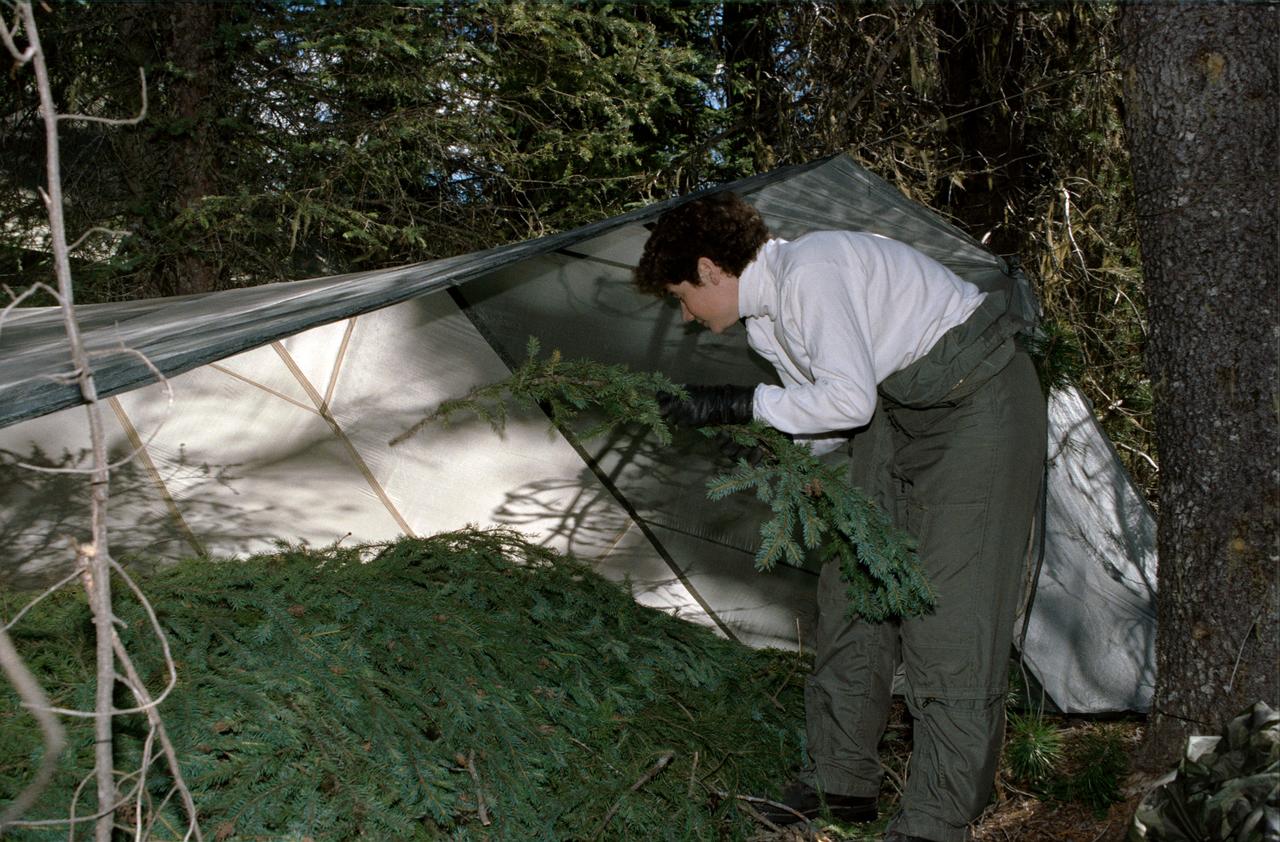
1990 Group 13 Astronaut Candidate (ASCAN) Susan J. Helms gathers pine branches to create bedding under a tent she has constructed from a parachute. Helms, along with her classmates, is participating in wilderness survival training at Fairchild Air Force Base (AFB) Spokane, Washington. The training was conducted in the mountain forests of Washington from 08-26-90 through 08-30-90.
This is an X-band black-and-white image of the forests east of the Baikal Forest in the Jablonowy Mountains of Russia. The image is centered at 52.5 degrees north latitude and 116 degrees east longitude near the mining town of Bukatschatscha. This image was acquired by the Spaceborne Imaging Radar-C/X-band Synthetic Aperture Radar aboard the space shuttle Endeavour on October 4, 1994, during the second flight of the spaceborne radar. This area is part of an international research project known as the Taiga Aerospace Investigation using Geographic Information System Applications. http://photojournal.jpl.nasa.gov/catalog/PIA01754
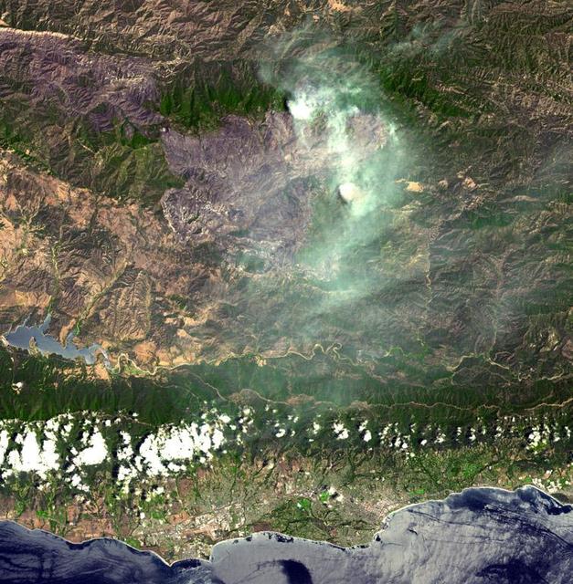
On August 7, 2007, the Zaca fire continued to burn in the Los Padres National Forest near Santa Barbara, California. This image is from NASA Terra spacecraft.
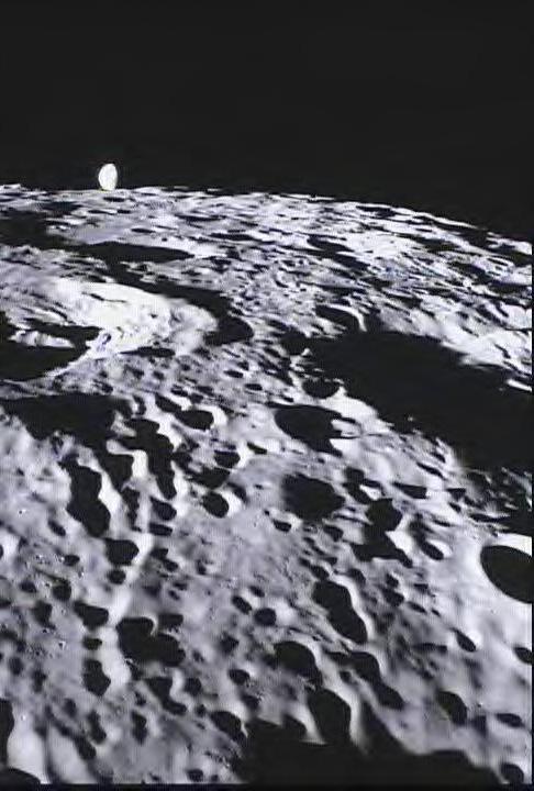
This image of the far side of the lunar surface, with Earth in the background, is of crater De Forest and was taken by NASA MoonKAM system onboard the Ebb spacecraft.
A destructive forest fire broke out June 24, 2007 near South Lake Tahoe, Calif. This image was acquired by NASA Terra on June 27, 2007.
NASA Terra spacecraft captured this thermal infrared view of the spread of the forest fire in Valle Nuevo National Park near Costanza, Dominican Republic.
The border between Belize and Guatemala illustrates striking differences in land use practices. In a study of deforestation published in 2016, Chicas and co-authors found that in their study area between 1991 and 2014, on the Guatemalan side of the border forested land declined 32%; in Belize, forested area declined 11%. In part of their study area shown in this image, the difference is more dramatic: near-pristine forest in Belize on the right, and agricultural fields in Guatemala on the left. The image was acquired May 10, 2016, covers an area of 27 by 41 km, and is located at 16.7 degrees north, 89.2 degrees west. https://photojournal.jpl.nasa.gov/catalog/PIA21826
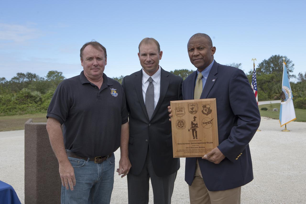
From left, Jon Wallace, deputy fire coordinator, U.S. Fish and Wildlife Service Southeast Region, Atlanta, Georgia; Chris Wilcox, U.S. Fish and Wildlife chief, Fire Management, National Interagency Fire Center, Boise, Idaho; and Kelvin Manning, associate director, NASA's Kennedy Space Center, pose for a portrait following a ceremony Nov. 1 on the Merritt Island National Wildlife Refuge in Florida. During the joint ceremony, the Spaceport Integration Team and its partners were presented with the prestigious 2017 Pulaski Award and a new memorial marker was dedicated. The multi-agency team includes representatives from NASA's Kennedy Space Center, Cape Canaveral Air Force Station's 45th Space Wing, the Merritt Island National Wildlife Refuge, as well as the Florida Forest Service and Brevard County Fire Rescue. The memorial marker honors two fallen firefighters, Scott Maness and Beau Sauselein, who died fighting a wildfire on space center property in 1981. Held outdoors, the ceremony was attended by 140 guests.
From left, Jon Wallace, deputy fire coordinator, U.S. Fish and Wildlife Service Southeast Region, Atlanta, Georgia; Chris Wilcox, U.S. Fish and Wildlife chief, Fire Management, National Interagency Fire Center, Boise, Idaho; and Mark Schollmeyer, chief, Brevard County Fire Rescue, pose for a portrait following a ceremony Nov. 1 on the Merritt Island National Wildlife Refuge in Florida. During the joint ceremony, the Spaceport Integration Team and its partners were presented with the prestigious 2017 Pulaski Award and a new memorial marker was dedicated. The multi-agency team includes representatives from NASA's Kennedy Space Center, Cape Canaveral Air Force Station's 45th Space Wing, the Merritt Island National Wildlife Refuge, as well as the Florida Forest Service and Brevard County Fire Rescue. The memorial marker honors two fallen firefighters, Scott Maness and Beau Sauselein, who died fighting a wildfire on space center property in 1981. Held outdoors, the ceremony was attended by 140 guests.
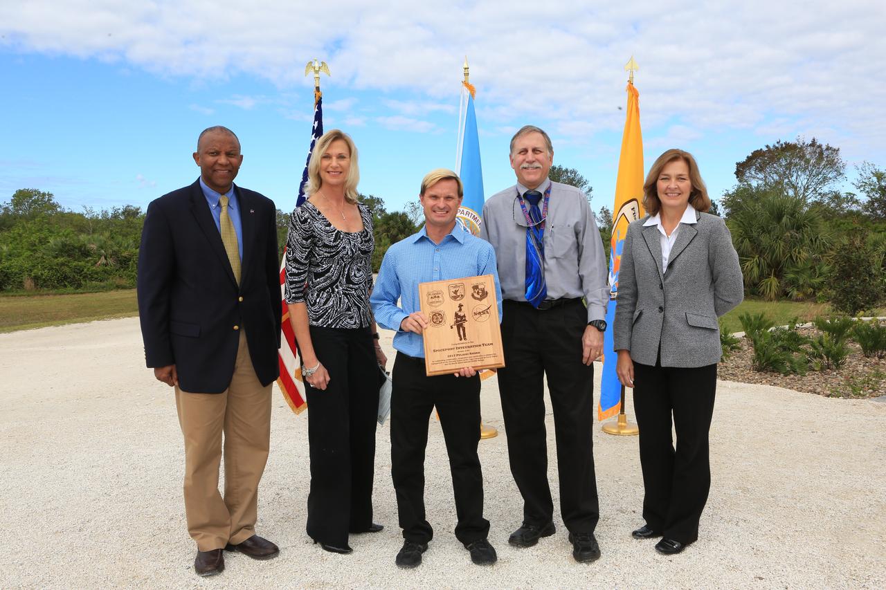
NASA's Kennedy Space Center Associate Director Kelvin Manning, left, and representatives from Kennedy's Spaceport Integration and Services pose for a portrait following a ceremony Nov. 1 on the Merritt Island National Wildlife Refuge in Florida. Next to Manning are, from left, Nancy Bray, director; William Heidtman, Spaceport Integrator; Dan Tweed, deputy director, Technical; and Jean Flowers, chief, Customer Services and Integration Branch. During the joint ceremony, the Spaceport Integration Team and its partners were presented with the prestigious 2017 Pulaski Award and a new memorial marker was dedicated. The multi-agency team includes representatives from NASA's Kennedy Space Center, Cape Canaveral Air Force Station's 45th Space Wing, the Merritt Island National Wildlife Refuge, as well as the Florida Forest Service and Brevard County Fire Rescue. The memorial marker honors two fallen firefighters, Scott Maness and Beau Sauselein, who died fighting a wildfire on space center property in 1981. Held outdoors, the ceremony was attended by 140 guests.
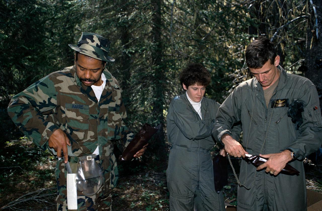
1990 Group 13 Astronaut Candidates (ASCANs) (left to right) Bernard J. Harris, Jr, Susan J. Helms, and William S. McArthur, Jr open dehydrated food packages during wilderness survival training at Fairchild Air Force Base (AFB) in Spokane, Washington. The training was conducted in the mountain forests of Washington from 08-26-90 through 08-30-90.
Mount Mabu in northern Mozambique is famous for its old-growth rain forest. The 75 square kilometers forest and its extremely diverse wildlife were unknown to scientists until 2005. One scientist believes he has discovered 15 new species of dung beetles. At least 25 additional new species of animals have also been found. The image was acquired October 4, 2023, covers an area of 26.7 by 28.8 km, and is located at 16.3 degrees south, 36.4 degrees east. https://photojournal.jpl.nasa.gov/catalog/PIA26392
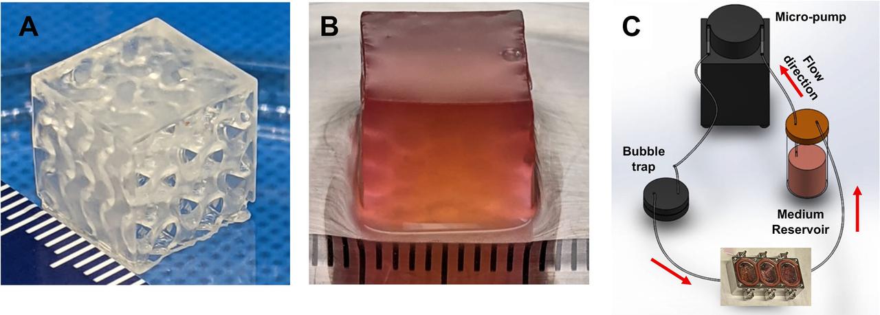
jsc2024e043915 (6/17/2024) --- Maturation of Vascularized Liver Tissue Construct in Zero Gravity (MVP Cell-07) examines the behavior in microgravity of bioprinted or engineered liver tissue constructs that contain blood vessels. This preflight image shows A) Bioprinted vascularized construct with a gyroid design consisting of interconnected channels. B) Bioprinted human liver tissue construct fabricated using a digital light projection (DLP) printer. C) The tissue construct-containing flow chamber is connected to a perfusion system. Data from this vascularized liver tissue construct helps support the development of clinically relevant organs on Earth. Image courtesy of the Wake Forest Institute for Regenerative Medicine.

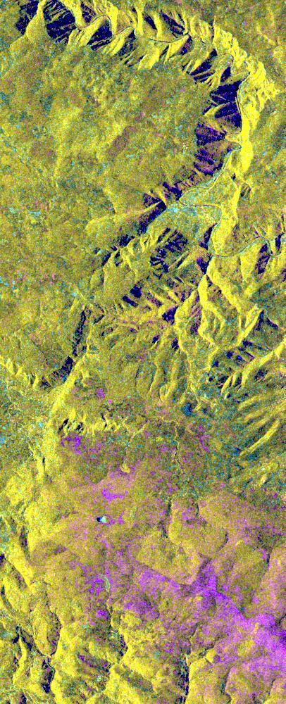
STS059-S-039 (11 April 1994) --- This is a false-color composite of Prince Albert, Canada, centered at 53.91 north latitude and 104.69 west longitude. This image was acquired by the Spaceborne Imaging Radar-C and X-Band Synthetic Aperture Radar (SIR-C/X-SAR) aboard the Space Shuttle Endeavour on its 20th orbit. The area is located 40 kilometers (25 miles) north and 30 kilometers (20 miles) east of the town of Prince Albert in the Saskatchewan province of Canada. The image covers the area east of the Candle Lake, between gravel surface Highways 120 and 106 and west of 106. The area in the middle of the image covers the entire Nipawin (Narrow Hills) provincial park. The look angle of the radar is 30 degrees and the size of the image is approximately 20 kilometers by 50 kilometers (12 by 30 miles). The image was produced by using only the L-Band. The three polarization channels HH, HV and VV are illustrated by red, green and blue respectively. The changes in the intensity of each color are related to various surface conditions such as variations in forest stands, frozen or thawed condition of the surface, disturbances (fire and deforestation), and areas of re-growth. Most of the dark areas in the image are the ice-covered lakes in the region. The dark area on the top right corner of the image is the White Gull Lake north of the intersection of Highway 120 and 913. The right middle part of the image shows Lake Ispuchaw and Lower Fishing Lake. The deforested areas are also shown by dark areas in the image. Since most of the logging practice at the Prince Albert area is around the major highways, the deforested areas can be easily detected as small geometrically shaped dark regions along the roads. At the time of the SIR-C/X-SAR overpass, a major part of the forest is either frozen or undergoing the spring thaw. The L-Band HH shows a high return in the jack pine forest. The reddish areas in the image are old jack pine forest, 12-17 meters (40-55 feet) in height and 60-75 years old. The orange-greenish areas are young jack pine trees, 3-5 meters (10-16 feet) in height and 11-16 years old. The green areas are due to the relative high intensity of the HV channel which is strongly correlated with the amount of biomass. L-Band HV channel shows the biomass variations over the entire region. Most of the green areas, when compared to the forest cover maps are identified as black spruce trees. The dark blue and dark purple colors show recently harvested or re-growth areas respectively. SIR-C/X-SAR is part of NASA's Mission to Planet Earth (MTPE). SIR-C/X-SAR radars illuminate Earth with microwaves allowing detailed observations at any time, regardless of weather or sunlight conditions. SIR-C/X-SAR uses three microwave wavelengths: L-Band (24 cm), C-Band (6 cm), and X-Band (3 cm). The multi-frequency data will be used by the international scientific community to better understand the global environment and how it is changing. The SIR-C/X-SAR data, complemented by aircraft and ground studies, will give scientists clearer insights into those environmental changes which are caused by nature and those changes which are induced by human activity. SIR-C was developed by NASA's Jet Propulsion Laboratory (JPL). X-SAR was developed by the Dornire and Alenia Spazio Companies for the German Space Agency, Deutsche Agentur fuer Raumfahrtangelegenheiten (DARA), and the Italian Space Agency, Agenzia Spaziale Italiana (ASI). JPL Photo ID: P-43886
STS059-S-079 (18 April 1994) --- This is a false-color, three frequency image of Prince Albert, Canada, centered at 53.91 north latitude and 104.69 west longitude. It was produced using data from the X-Band, C-Band and L-Band radars that comprise the Spaceborne Imaging Radar-C and X-Band Synthetic Aperture Radar (SIR-C/X-SAR). SIR-C/X-SAR acquired this image on the 20th orbit of the Space Shuttle Endeavour. The area is located 40 kilometers north and 30 kilometers east of the town of Prince Albert in the Saskatchewan province of Canada. The image covers the area east of the Candle Lake, between gravel surface Highways 120 and 106 and west of 106. The area in the middle of the image covers the entire Nipawin (Narrow Hills) provincial park. The look angle of the radar is 30 degrees and the size of the image is approximately 20 by 50 kilometers. The red, green, and blue colors represent L-Band total power, C-Band total power, and XVV respectively. The changes in the intensity of each color are related to various surface conditions such as frozen or thawed forest, fire, deforestation and areas of regrowth. Most of the dark blue areas in the image are the ice covered lakes. The dark area on the top right corner of the image is the White Gull Lake north of the intersection of Highway 120 and 913. The right middle part of the image shows Lake Ispuchaw and Lower Fishing Lake. The deforested areas are shown by light blue in the image. Since most of the logging practice at the Prince Albert area is around the major highways, the deforested areas can be easily detected as small geometrically shaped dark regions along the roads. At the time these data were taken, a major part of the forest was either frozen or undergoing the spring thaw. In such conditions, due to low volume of water in the vegetation, a deeper layer of the canopy is imaged by the radar, revealing valuable information about the type of trees, the amount of vegetation biomass and the condition of the surface. As the frequency increases, the penetration depth in the canopy decreases. Over forest canopies, the X-Band radar contains information about the top of the canopy. Whereas, C-Band and L-Band radar returns show contributions from the crown and trunk areas respectively. The bright areas in the image are dense mixed aspen and old jackpine forests where the return from all three bands is high. The reddish area corresponds to more sparse old jack pine (12 to 17 meters in height and 60 to 75 years old) where the L-Band signal penetrates deeper in the canopy and dominates C-Band and X-Band returns. Comparison of the image with the forest cover map of the area indicates that the three band radar can be used to classify various stands. SIR-C/X-SAR is part of NASA's Mission to Planet Earth (MTPE). SIR-C/X-SAR radars illuminate Earth with microwaves allowing detailed observations at any time, regardless of weather or sunlight conditions. SIR-C/X-SAR uses three microwave wavelengths: L-Band (24 cm), C-Band (6 cm), and X-Band (3 cm). The multi-frequency data will be used by the international scientific community to better understand the global environment and how it is changing. The SIR-C/X-SAR data, complemented by aircraft and ground studies, will give scientists clearer insights into those environmental changes which are caused by nature and those changes which are induced by human activity. SIR-C was developed by NASA's Jet Propulsion Laboratory (JPL). X-SAR was developed by the Dornire and Alenia Spazio Companies for the German Space Agency, Deutsche Agentur fuer Raumfahrtangelegenheiten (DARA), and the Italian Space Agency, Agenzia Spaziale Italiana (ASI). JPL Photo ID: P-43929

iss071e462173 (Aug. 8, 2024) --- Wildfires in northern California are pictured from the International Space Station as it orbited 261 miles above the Pacific Ocean off the coast of Washington's Olympic National Forest.
This is a color composite image of southern Bahia, Brazil, centered at 15.22 degree south latitude and 39.07 degrees west longitude. The image was acquired by the Spaceborne Imaging Radar-C/X-band Synthetic Aperture Radar aboard the space shuttle Endeavour on its 38th orbit of Earth on October 2, 1994. The image covers an area centered over the Una Biological Reserve, one the largest protected areas in northeastern Brazil. The 7,000-hectare reserve is administered by the Brazilian Institute for the Environment and is part of the larger Atlantic coastal forest, a narrow band of rain forest extending along the eastern coast of Brazil. The Atlantic coastal forest of southern Bahia is one of the world's most threatened and diverse ecosystems. Due to widespread settlement, only 2 to 5 percent of the original forest cover remains. Yet the region still contains an astounding variety of plants and animals, including a large number of endemic species. More than half of the region's tree species and 80 percent of its animal species are indigenous and found nowhere else on Earth. The Una Reserve is also the only federally protected habitat for the golden-headed lion tamarin, the yellow-breasted capuchin monkey and many other endangered species. In the past few years, scientists from Brazilian and international conservation organizations have coordinated efforts to study the biological diversity of this region and to develop practical and economically viable options for preserving the remaining primary forests in southern Bahia. The shuttle imaging radar is used in this study to identify various land uses and vegetation types, including remaining patches of primary forest, cabruca forest (cacao planted in the understory of the native forest), secondary forest, pasture and coastal mangrove. Standard remote-sensing technology that relies on light reflected from the forest canopy cannot accurately distinguish between cabruca and undisturbed forest. Optical remote sensing is also limited by the nearly continuous cloud cover in the region and heavy rainfall, which occurs more than 150 days each year. The ability of the shuttle radars to "see" through the forest canopy to the cultivated cacao below -- independent of weather or sunlight conditions --will allow researchers to distinguish forest from cabruca in unprecedented detail. This SIR-C/X-SAR image was produced by assigning red to the L-band, green to the C-band and blue to the X-band. The Una Reserve is located in the middle of the image west of the coastline and slightly northwest of Comandatuba River. The reserve's primary forests are easily detected by the pink areas in the image. The intensity of red in these areas is due to the high density of forest vegetation (biomass) detected by the radar's L-band (horizontally transmitted and vertically received) channel. Secondary forest is visible along the reserve's eastern border. The Serrado Mar mountain range is located in the top left portion of the image. Cabruca forest to the west of Una Reserve has a different texture and a yellow color. The removal of understory in cabruca forest reduces its biomass relative to primary forest, which changes the L-band and C-band penetration depth and returns, and produces a different texture and color in the image. The region along the Atlantic is mainly mangrove swamp, agricultural fields and urban areas. The high intensity of blue in this region is a result of increasing X-band return in areas covered with swamp and low vegetation. The image clearly separates the mangrove region (east of coastal Highway 001, shown in blue) from the taller and dryer forest west of the highway. The high resolution capability of SIR-C/X-SAR imaging and the sensitivity of its frequency and polarization channels to various land covers will be used for monitoring and mapping areas of importance for conservation. http://photojournal.jpl.nasa.gov/catalog/PIA01764
STS059-S-068 (13 April 1994) --- This false-color L-Band image of the Manaus region of Brazil was acquired by the Spaceborne Imaging Radar-C and X-Band Synthetic Aperture Radar (SIR-C/X-SAR) aboard the Space Shuttle Endeavour on orbit 46 of the mission. The area shown is approximately 8 kilometers by 40 kilometers (5 by 25 miles). At the top of the image are the Solimoes and Rio Negro Rivers just before they combine at Manaus to form the Amazon River. The image is centered at about 3 degrees south latitude, and 61 degrees west longitude. The false colors are created by displaying three L-Band polarization channels; red areas correspond to high backscatter at HH polarization, while green areas exhibit high backscatter at HV polarization. Blue areas show low returns at VV polarization; hence the bright blue colors of the smooth river surfaces. Using this color scheme, green areas in the image are heavily forested, while blue areas are either cleared forest or open water. The yellow and red areas are flooded forest. Between Rio Solimoes and Rio Negro a road can be seen running from some cleared areas (visible as blue rectangles north of Rio Solimoes) north towards a tributary of Rio Negro. SIR-C/X-SAR is part of NASA's Mission to Planet Earth (MTPE). SIR-C/X-SAR radars illuminate Earth with microwaves allowing detailed observations at any time, regardless of weather or sunlight conditions. SIR-C/X-SAR uses three microwave wavelengths: L-Band (24 cm), C-Band (6 cm), and X-Band (3 cm). The multi-frequency data will be used by the international scientific community to better understand the global environment and how it is changing. The SIR-C/X-SAR data, complemented by aircraft and ground studies, will give scientists clearer insights into those environmental changes which are caused by nature and those changes which are induced by human activity. SIR-C was developed by NASA's Jet Propulsion Laboratory (JPL). X-SAR was developed by the Dornire and Alenia Spazio Companies for the German Space Agency, Deutsche Agentur fuer Raumfahrtangelegenheiten (DARA), and the Italian Space Agency, Agenzia Spaziale Italiana (ASI). JPL Photo ID: P-43895
This spaceborne radar image shows a segment of the Rhine River where it forms the border between the Alsace region of northeastern France on the left and the Black Forest region of Germany on the right.
More than 2 million acres were consumed by hundreds of fires between December 2002 and February 2003 in southeastern Australia national parks, forests, foothills and city suburbs as seen by NASA Terra spacecraft.
This image, acquired by NASA Terra spacecraft, is of the Pole Creek fire southwest of Sisters, Ore., which had grown to 24,000 acres as of Sept. 20, 2012. No structures have been destroyed, and the fire is mostly confined to the national forest.
These images of Canada Québec province were acquired by NASA Terra satelliteon March 4, 2001.The region forests are a mixture of coniferous and hardwood trees, and ugar-shack festivities are held at this time of year to celebrate the beginning o
NASA Terra spacecraft acquired this image of the region north of Lake Baikal on Aug. 22, 2015. For weeks, forest fires have been raging in Siberia around Russia Lake Baikal.

Logging operations have left a striking checkerboard pattern in the landscape along the Idaho-Montana border, sandwiched between Clearwater and Bitterroot National Forests as seen in this image acquired by NASA Terra spacecraft.
A look at smoke from the Chisholm forest fire, which ignited on May 23, 2001 about 160 kilometers north of Edmonton in Alberta, Canada, as seen by NASA Terra spacecraft.
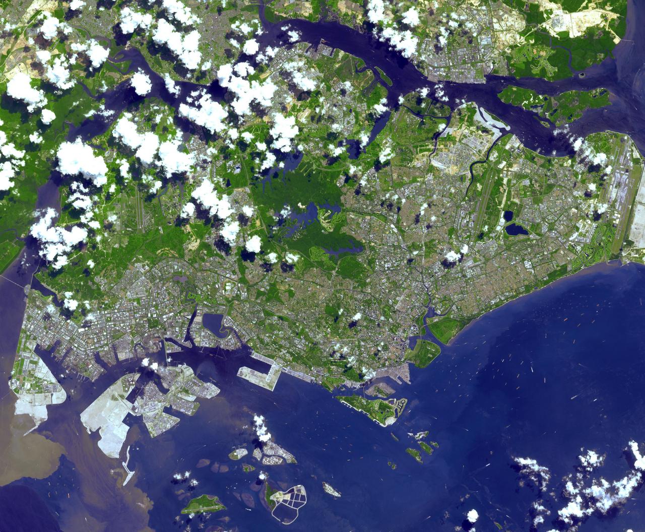
This image from NASA Terra spacecraft is of the Republic of Singapore, a city-state off the southern tip of the Malay Peninsula. An island country made up of 63 islands, the country is largely urbanized with very little rain forest left.
Two hundred years ago, Ascension Island was a barren volcanic edifice. This image from NASA Terra spacecraft shows that today its peaks are covered by lush tropical cloud forest.
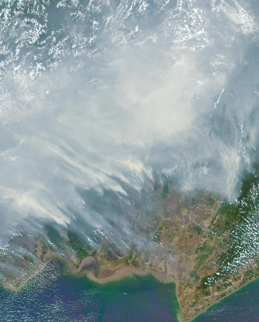
The worst forest fires in nearly two decades are burning out of control on Borneo, creating the thick blanket of smoke in this Oct. 14, 2015 image from NASA Terra spacecraft.
During the 2003 fire season, blazes in the taiga forests of Eastern Siberia were part of a vast network of fires across Siberia and the Russian Far East, northeast China and northern Mongolia seen here by NASA Terra spacecraft.

W44 is located around 10,000 light-years away, within a forest of dense star-forming clouds in the constellation of Aquila, the Eagle. This image combines data from ESA Herschel and XXM-Newton space observatories.
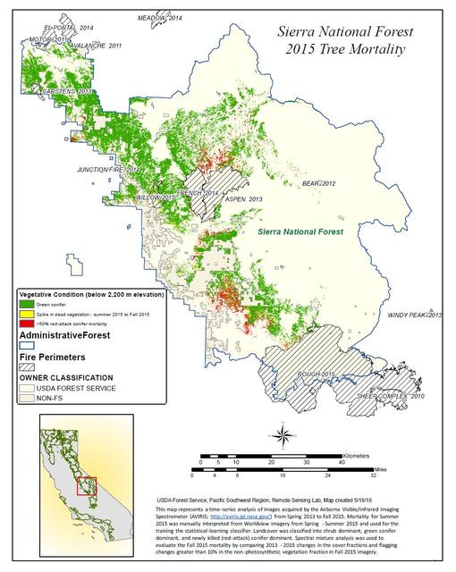
California, reveals the devastating effect of California's ongoing drought on Sierra Nevada conifer forests. The map will be used to help the U.S. Forest Service assess and respond to the impacts of increased tree mortality caused by the drought, particularly where wildlands meet urban areas within the Sierra National Forest. After several years of extreme drought, the highly stressed conifers (trees or bushes that produce cones and are usually green year-round) of the Sierra Nevada are now more susceptible to bark beetles (Dendroctonus spp.). While bark beetles killing trees in the Sierra Nevada is a natural phenomenon, the scale of mortality in the last couple of years is far greater than previously observed. The U.S. Forest Service is using recent airborne spectroscopic measurements from NASA's Airborne Visible/Infrared Imaging Spectrometer (AVIRIS) instrument aboard NASA's ER-2 aircraft, together with new advanced algorithms, to quantify this impact over this large region of rugged terrain. The high-altitude ER-2 aircraft is based at NASA's Armstrong Flight Research Center, Edwards, California. The image was created by scientists at the USFS's Pacific Southwest Region Remote Sensing Lab, McClellan, California, by performing a time series analysis of AVIRIS images. Scientists evaluated baseline tree mortality on public lands in the summer of 2015 using a machine learning algorithm called "random forest." This algorithm classifies the AVIRIS measurements as dominated by either shrubs, healthy trees or newly dead conifer trees. To quantify how much the amount of dead vegetation increased during the fall of 2015, the Forest Service scientists conducted an advanced spectral mixture analysis. This analysis evaluates each spectrum to determine the fraction of green vegetation, dead vegetation and soil. The full spectral range of AVIRIS is important to separate the signatures of soil and dead vegetation. To produce this comprehensive Sierra National Forest tree mortality map, the result from the summer of 2015 was evaluated to look for increases of more than 10 percent in dead vegetation during the fall of 2015. AVIRIS measures spectra of the Earth system to conduct advanced science research. These western U.S. AVIRIS measurements were acquired as part of NASA's Hyperspectral Infrared Imager (HyspIRI) preparatory airborne campaign. HyspIRI was one of the space missions suggested to NASA by the National Academy of Sciences in its 2007 decadal survey for Earth Science. In the future, HyspIRI could provide spectral and thermal measurements of this type globally for ecosystem research and additional science objectives. http://photojournal.jpl.nasa.gov/catalog/PIA20717
This is an X-band seasonal image of the central part of Lozere Departement situated south of the Massif Central in France. The image is 10 kilometers by 25 kilometers (6 miles by 15.5 miles) and is centered at approximately 44.3 degrees north latitude and 3 degrees east longitude. This image was acquired by the Spaceborne Imaging Radar-C/X-band Synthetic Aperture Radar aboard the space shuttle Endeavour on April 15, 1994 and on October 6, 1994. The image channels have the following color assignments: red was acquired in April; green was acquired in October; and blue is the ratio of the two data sets combined. Seasonal differences in the vegetation are visible in pink, which are heaths growing in the spring. This research area features two large limestone plateaus cut by the famous Gorges du Tarn, standing in parallel with the granite mountain range known as the Cevennes Mountains nearby. Land-use consists mainly of grasslands, heaths and forests. Forest types seen in the images are Austrian pines,Scots pines, spruce, fir and beech trees. Most forests were planted at the end of the 19th century through a national reforestation program aimed at reducing the strong erosion risks in these areas. This program was so successful that today the forests are exploited for forest pulpwood and sawlogs, but also remain protected as conservation regions. The study being performed in this area will assess the potential of spaceborne radar remote sensing for temperate forest type mapping and forest resource monitoring. The combination of X-band SAR data with lower frequency data (such as the SIR-C L-band data) allows scientists to distinguish forest tree species and biomass, or areas of ground vegetation. The lessons learned from the radar images of these controlled forest regions can be applied to larger areas and naturally grown forests to help ecologists protect and maintain them. The SIR-C/X-SAR images will be investigated by scientists from the remote sensing laboratory Cemagref in Montpellier and the National Forestry Board in Mende, France. http://photojournal.jpl.nasa.gov/catalog/PIA01755
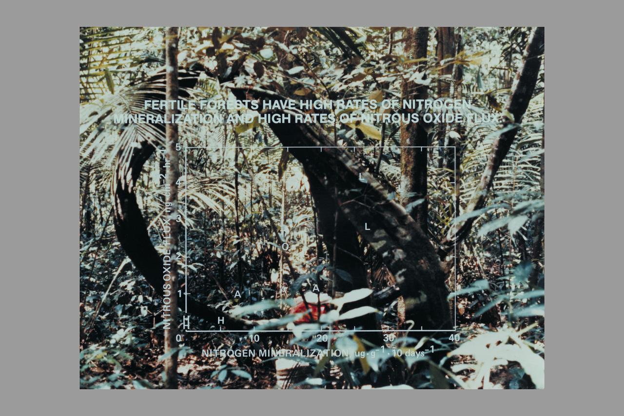
Nitrogen mineralization (Nitrous Oxide Flux): Fertile Forest

Kepler Project Team member Forest Girouard
The southwestern border of Brunei with Sarawak, Malaysia is strikingly apparent due to differences in land use practice. On the Malaysian side, a spider web of small roads indicates intensive land use: in this case clearing of the forest for palm oil plantations. On the Brunei side, the virgin forest is preserved, with few if any roads cutting through the forest. The image was acquired September 10, 2012, covers an area of 38 by 38 km, and is located at 4.2 degrees north, 114.4 degrees east. https://photojournal.jpl.nasa.gov/catalog/PIA22034

STS060-87-087 (3-11 Feb 1994) --- Lake Baikal, in southeastern Siberia, is the largest freshwater lake in the world by volume, holding nearly 20 per cent of the world's fresh water. Lake Baikal is a biospheric reserve of high international interest to the global scientific community. It is home to some 600 endemic species, many found in no other location. This view shows the northern end of the lake, and was taken in the early morning with low sun highlighting the mountain ranges rimming the lake basin. Pristine forests surround the lake, although heavy logging is evident in other photography of the central and southern portions of the lake. Another unique aspect of Lake Baikal is the existence of the world's only known freshwater hydrothermal springs. The fault system which bounds the lake allows fluids to circulate deep into the Earth and resurface as hot springs around and in the lake. Russian and American scientists are using the Shuttle photography to examine the relationship of the lake's ice cover to areas of known hydrothermal activity. Thus Lake Baikal has been and continues to be a high-priority site for photography from space from both the Space Shuttle and the Russian Space Station MIR.
In northern Argentina's Salta province, the chaco forests, made up of shrubs and hardwood trees, once thrived in the region. In the past 30 years, large-scale farming and ranch operators have cleared broad areas of the chaco, and replaced with industrial-scale raising of crops and livestock. The December 1, 1989 Landsat TM image is dominiated by traditional puestos, settlements consisting of a few dwellings and small-scale crops located near a well. The November 19, 2019 ASTER image shows large fields arranged in a grid pattern. The chaco forest has almost disappeared. The images cover an area of 22.2 by 27.8 km, and are located at 24.9 degrees south, 63.5 degrees west. https://photojournal.jpl.nasa.gov/catalog/PIA23756
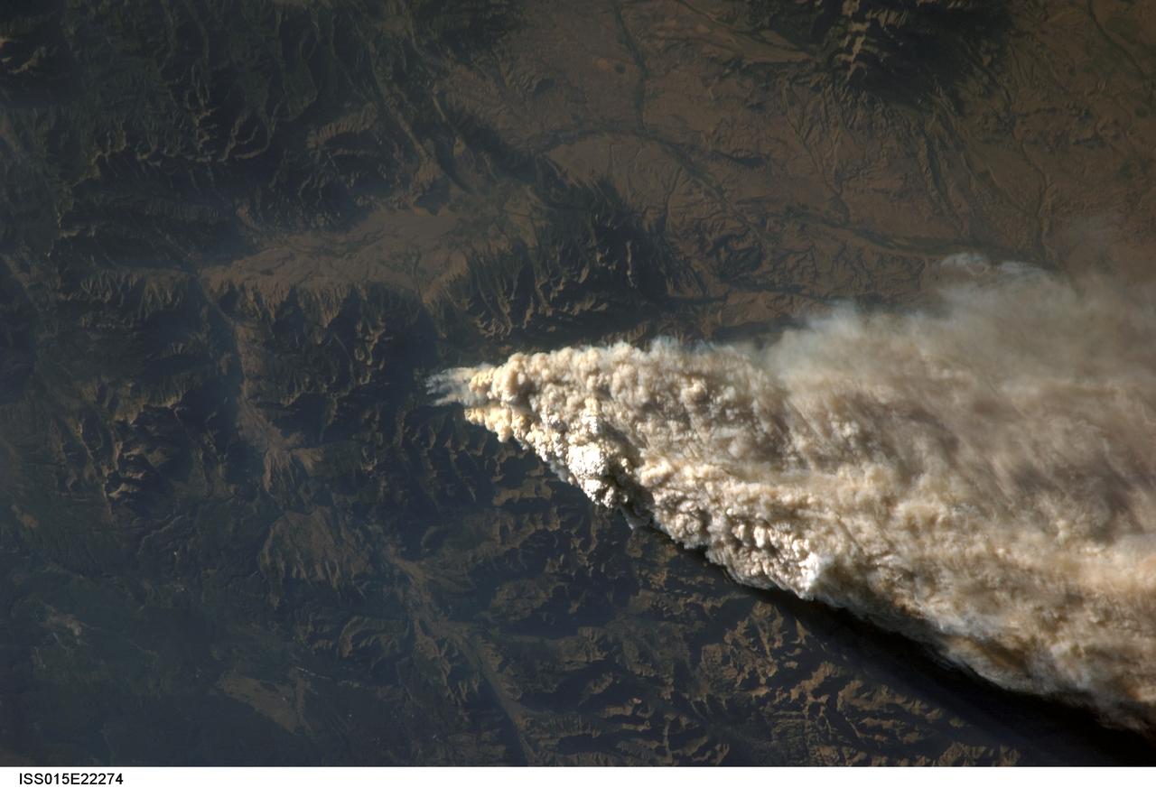
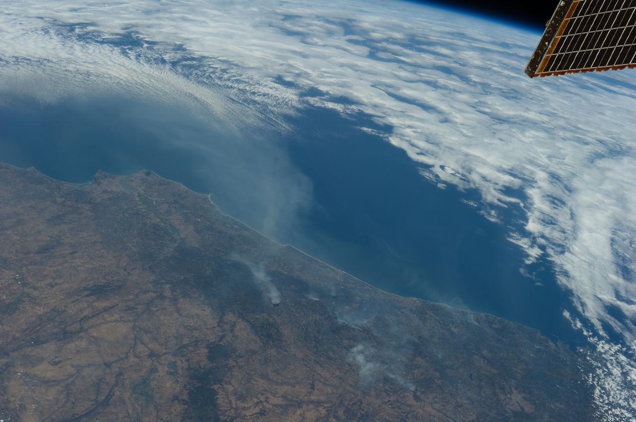
ISS015-E-22274 (13 Aug. 2007) --- Smoke plumes from a forest fire in the Gallatin National Forest, Montana is featured in this image photographed by an Expedition 15 crewmember on the International Space Station while Space Shuttle Endeavour (STS-118) was docked with the station.

A Cal Fire S2-T airtanker follows a U.S. Forest Service King Air 200 during an aerial attack on a simulated wildfire, Tuesday, May 4, 2021 as Cal Fire conducts aerial fire fighting training exercises near Redding, California. STEReO, the Scalable Traffic Management for Emergency Response Operations project, led by NASA’s Ames Research Center, builds on NASA’s expertise in air traffic management, human factors research, and autonomous technology development to apply the agency’s work in Unmanned Aircraft Systems Traffic Management, or UTM, to public safety uses. Photo Credit: (NASA/Joel Kowsky)
Mt. St. Helens Volcano - post eruption, forest damage
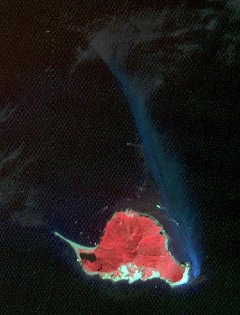
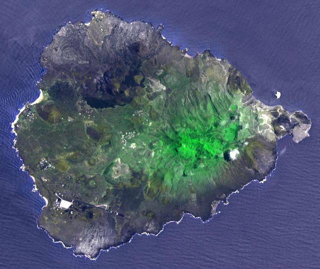
Twelve km off Taiwan's NE coast lies Turtle Island, a forest-covered volcanic island. The bluish patch of water on the island's eastern side (nicknamed the Milky Sea) marks the site of dozens of hydrothermal vents, spewing out hot, acidic water laden with heavy metals and toxic gases. The image was acquired October 4, 2020, covers an area of 10.6 by 13.9 km, and is located at 24.8 degrees north, 122 degrees east. (credit BBC News for this information) https://photojournal.jpl.nasa.gov/catalog/PIA24950

STS039-83-059 (28 April-6 May 1991) --- This high oblique view taken from over southeastern Quebec, looking to the southwest down the estuary of the St. Lawrence River (Fleuve Saint-Laurent). The primary road on the north side of the river (right) runs from Quebec, at the end of the estuary behind Ile D'Orleans, northeast to its terminus at Sept-Iles (near nadir, and not visible in this scene). The St. Lawrence disappears underneath the cloud bank over western New York and Ontario just to the west of Montreal. The light snow cover enhances the area of forests (dark) and non-forest (white). In this view, most of the irregular areas of white on the right side of the St. Lawrence River are previously forested areas that were burned over during the extraordinary Canadian forest fires of 1989.
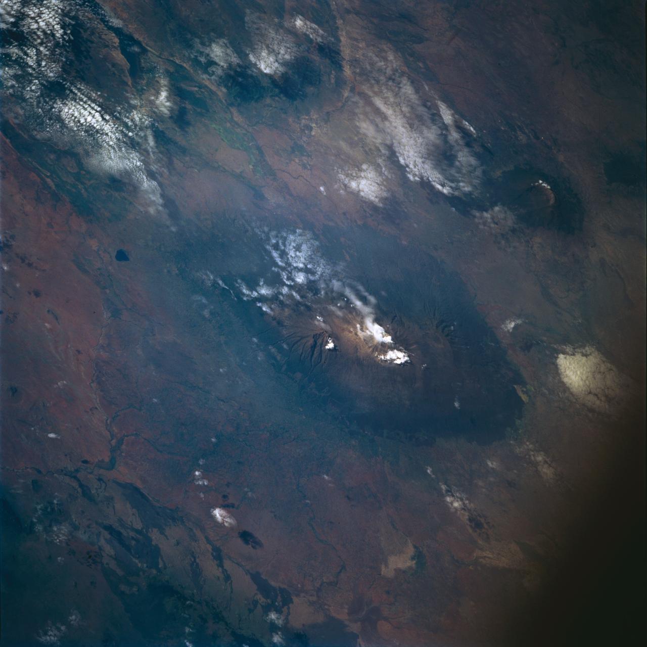
STS072-722-004 (11-20 Jan. 1996) --- Mount Kilimanjaro in Tanzania is featured in this 70mm frame exposed from the Earth-orbiting Space Shuttle Endeavour. Orient with the clouds trailing to the left; then the view is southwest from Kenya past Kilimanjaro to Mount Meru, in Tanzania. Mount Kilimanjaro is about three degrees south of the Equator, but at nearly 6,000 meters has a permanent snowfield. The mountain displays a classic zonation of vegetation types from seasonally dry savannah on the plains at 1,000 meters, to the cloud forest near the top. The mountain is being managed experimentally as an international biosphere reserve. A buffer zone of "traditional" agriculture and pastoral land use is designated around the closed-canopy forest reserve. Specialists familiar with this area say management is partially successful so far, but cleared areas of the forest can be seen on this photograph as light green "nibbles" or "cookie cuts" extending into the dark forest region.
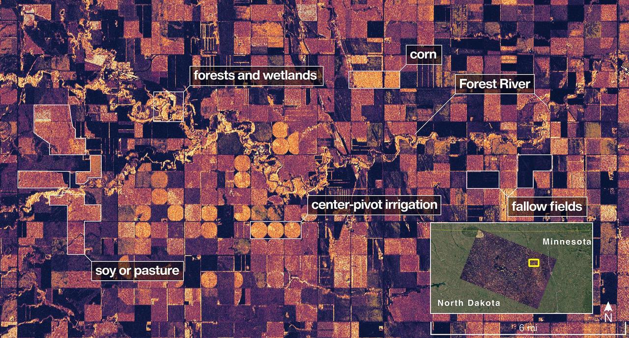
The NISAR (NASA-ISRO Synthetic Aperture Radar) Earth-observing radar satellite's L-band synthetic aperture radar (SAR) system captured an image of a portion of northeastern North Dakota straddling Grand Forks and Walsh counties on Aug. 23, 2025. Produced by scientists on the NISAR science team, the image shows forests and wetlands on the banks of the Forest River meandering through the middle of the frame from west to east and farmland to the north and south. The darker agricultural plots are fallow fields, while the lighter colors represent the presence of pasture or crops, such as soybean and corn. Circular patterns indicate the use of center-pivot irrigation. The satellite is a joint effort between NASA and the Indian Space Research Organisation (ISRO) and is the first satellite to combine L-band and S-band radar systems. The satellite's L-band system, provided by NASA's Jet Propulsion Laboratory in Southern California, uses a 10-inch (25-centimeter) wavelength that enables its signal to penetrate forest canopies and measure soil moisture as well as motion of ice surfaces and land down to fractions of an inch – a key measurement in understanding how the land surface moves before, during, and after earthquakes, volcanic eruptions, and landslides. The NISAR S-band radar, provided by ISRO's Space Applications Centre, uses a 4-inch (10-centimeter) microwave signal that's more sensitive to small vegetation, which makes it effective at monitoring certain types of agriculture and grassland ecosystems. Data used to create the image was collected during NISAR's commissioning phase, when the spacecraft's systems and instruments are powered on and tested. The NISAR mission will begin science operations in November, roughly 90 days after its July 30, 2025, launch from Satish Dhawan Space Centre on India's southeastern coast. Observations from NISAR will benefit humanity by helping researchers around the world better understand changes in our planet's surface, including its ice sheets, glaciers, and sea ice. It also will capture changes in forest and wetland ecosystems and track movement and deformation of our planet's crust by phenomena such as earthquakes, landslides, and volcanic activity. The global and rapid coverage from NISAR will provide unprecedented support for disaster response, producing data to assist in mitigating and assessing damage, with observations before and after catastrophic events available in short time frames. https://photojournal.jpl.nasa.gov/catalog/PIA26615

S75-27445 (6 June 1975) --- American ASTP crewmen Vance D. Brand (left), Thomas P. Stafford (second from left) and Donald K. Slayton (right) receive a special box of genetically superior white spruce seeds from Glenn A. Kovar (second from right), USDA Forest Service project coordinator. The seeds, enough to plant an acre of trees, will be presented to the Soviet ASTP crewmen during the U.S.-USSR Apollo-Soyuz Test Project docking-in-Earth-orbit mission in July 1975. The seeds will produce faster-growing trees of exceptional height and shape. The trees will thrive in Moscow-like climate, and were developed by Forest Service?s Institute of Forest Genetics in Rhinelander, Wisconsin. The seed container box was made from recycled fibers and stabilized walnut. These seeds are an outstanding example of the U.S. Forest Service research to help produce new improved forests for the world. The four men are standing in the Building 2 briefing room at NASA's Johnson Space Center.
Earth observation taken during a day pass by the Expedition 36 crew. Per Twitter message: Forest fires in Portugal.
This image from NASA Terra spacecraft was acquired on Dec. 9, 2010 and shows Israel Carmel region near the city of Haifa where a deadly forest fire raged from Dec.3 to Dec.6, 2010; the burned areas appear in dark gray.
NASA Terra spacecraft passed over the Silver Fire in western New Mexico on June 7, 2013. It has since consumed more than 137,000 acres of timber in a rugged area of the Gila National Forest that has not seen large fires for nearly a century.
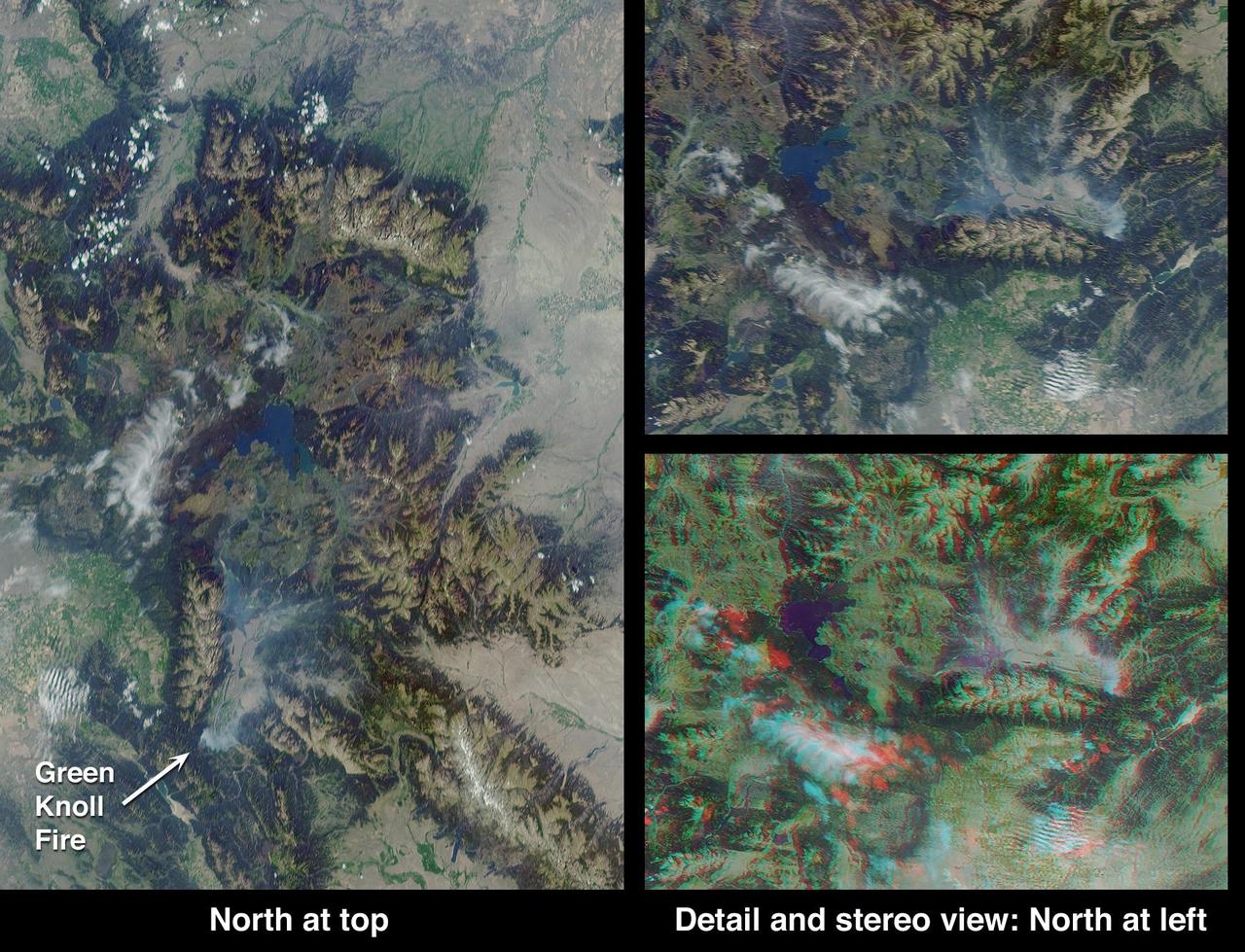
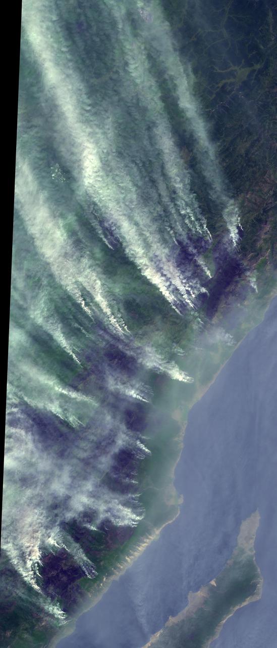
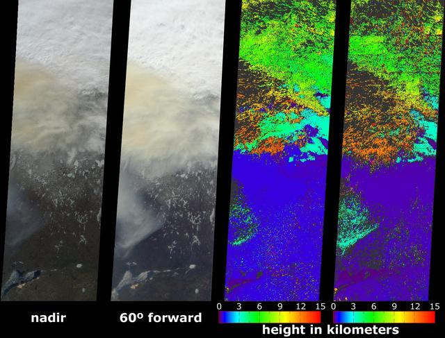
This anaglyph from the MISR instrument aboard NASA Terra spacecraft shows the area around Jackson Hole, Wyoming, where the Green Knoll forest fire raged for many days in July, 2001. 3D glasses are necessary to view this image.
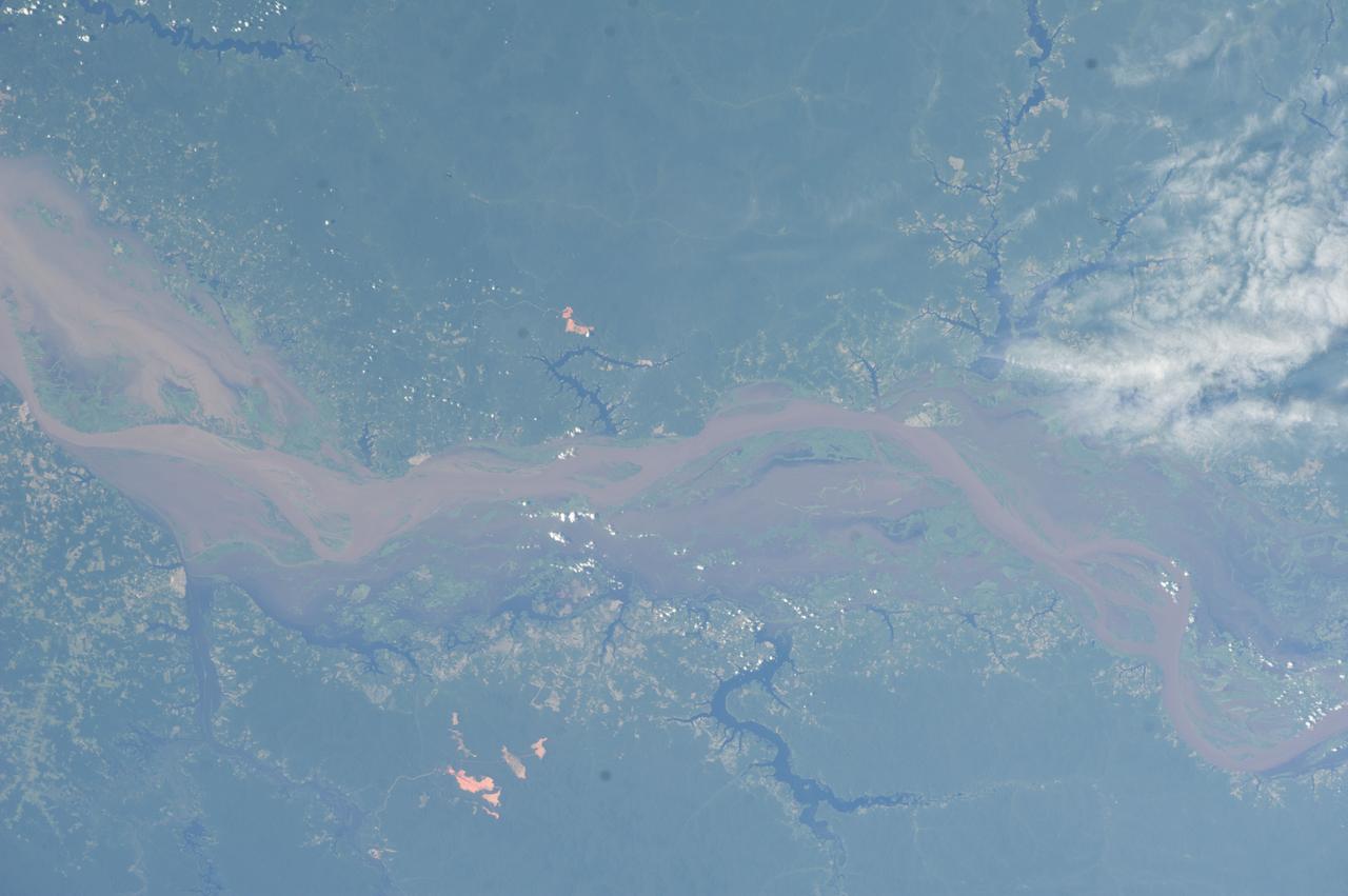
Earth observation taken during a day pass by the Expedition 40 crew aboard the International Space Station (ISS). Folder lists this as: Amazonian rain forest.