
51B-116-005 (29 April - 6 May 1985) --- Astronaut Don L. Lind, mission specialist, termed this scene of an aurora in the Southern Hemisphere as "spectacular," during a TV down link featuring discussion of the auroral observations on the seven-day flight. This scene was captured by astronaut Robert F. Overmyer, crew commander, using a 35mm camera. Dr. Lind, monitoring activity in the magnetosphere at various points throughout the flight, pinpointed the spacecraft's location as being over a point halfway between Australia and the Antarctic continent. There are moonlit clouds on Earth. The blue-green band and the tall red rays are aurora. The brownish band parallel to the Earth's horizon is a luminescence of the atmosphere itself and is referred to as airglow. Dr. T. Hallinan of the Geophysical Institute of Fairbanks serves as principal investigator for the auroral observations experiment and spent a great deal of time with Dr. Lind in preparation for the flight. Photo credit: NASA
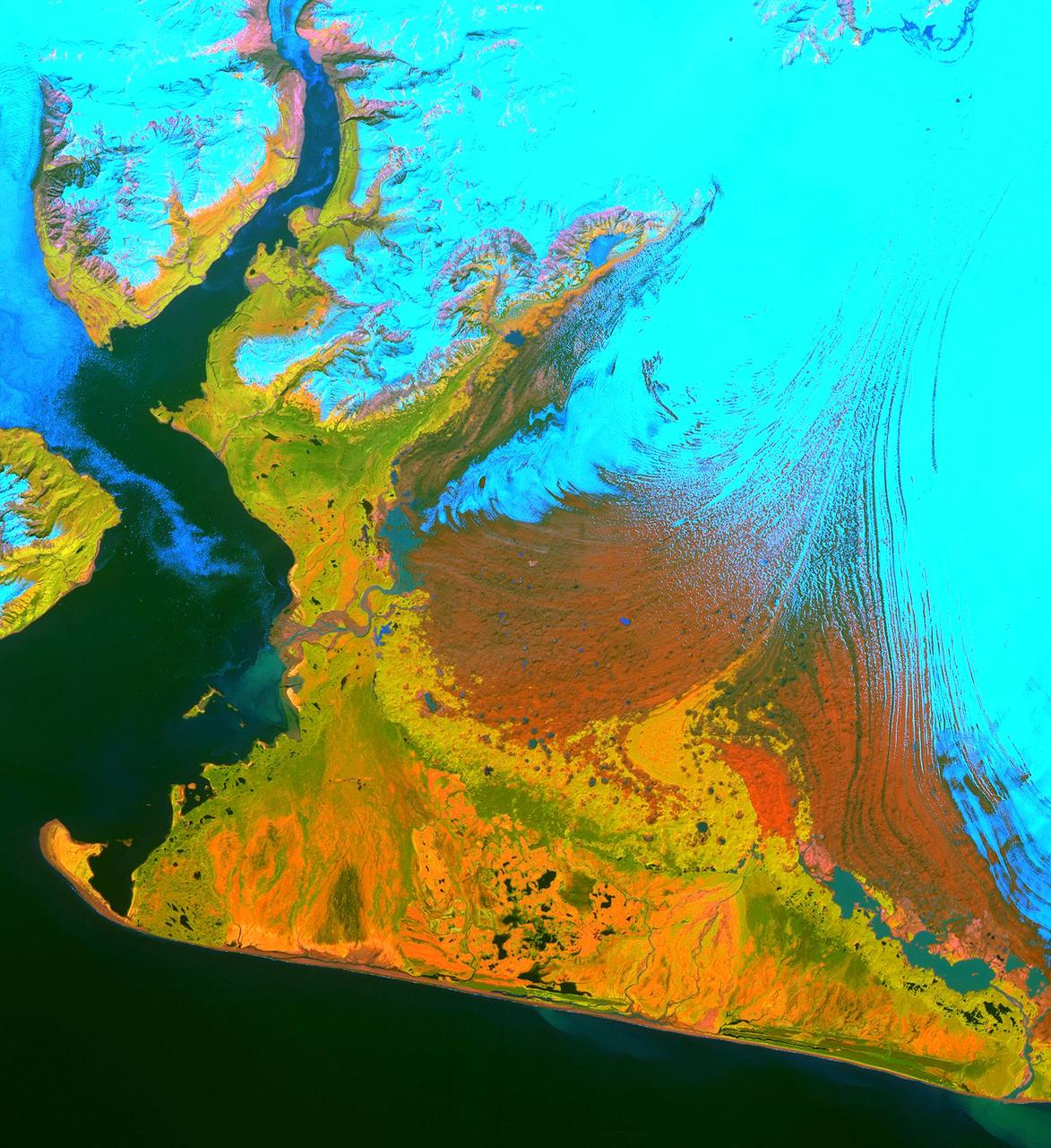
This image from the Advanced Spaceborne Thermal Emission and Reflection Radiometer (ASTER) instrument on NASA's Terra satellite covers an area of 55 by 40 kilometers (34 by 25 miles) over the southwest part of the Malaspina Glacier and Icy Bay in Alaska. The composite of infrared and visible bands results in the snow and ice appearing light blue, dense vegetation is yellow-orange and green, and less vegetated, gravelly areas are in orange. According to Dr. Dennis Trabant (U.S. Geological Survey, Fairbanks, Alaska), the Malaspina Glacier is thinning. Its terminal moraine protects it from contact with the open ocean; without the moraine, or if sea level rises sufficiently to reconnect the glacier with the ocean, the glacier would start calving and retreat significantly. ASTER data are being used to help monitor the size and movement of some 15,000 tidal and piedmont glaciers in Alaska. Evidence derived from ASTER and many other satellite and ground-based measurements suggests that only a few dozen Alaskan glaciers are advancing. The overwhelming majority of them are retreating. This ASTER image was acquired on June 8, 2001. With its 14 spectral bands from the visible to the thermal infrared wavelength region, and its high spatial resolution of 15 to 90 meters (about 50 to 300 feet), ASTER will image Earth for the next six years to map and monitor the changing surface of our planet. http://photojournal.jpl.nasa.gov/catalog/PIA03475

CAPE CANAVERAL, Fla. -- Team members from the University of Alaska-Fairbanks received the Judges' Innovation Award during NASA's 2014 Robotic Mining Competition awards ceremony inside the Space Shuttle Atlantis attraction at the Kennedy Space Center Visitor Complex in Florida. More than 35 teams from colleges and universities around the U.S. designed and built remote-controlled robots for the mining competition. The competition is a NASA Human Exploration and Operations Mission Directorate project designed to engage and retain students in science, technology, engineering and mathematics, or STEM, fields by expanding opportunities for student research and design. Teams use their remote-controlled robotics to maneuver and dig in a supersized sandbox filled with a crushed material that has characteristics similar to Martian soil. The objective of the challenge is to see which team’s robot can collect and move the most regolith within a specified amount of time. The competition includes on-site mining, writing a systems engineering paper, performing outreach projects for K-12 students, slide presentation and demonstrations, and team spirit. For more information, visit www.nasa.gov/nasarmc. Photo credit: NASA/Kim Shiflett
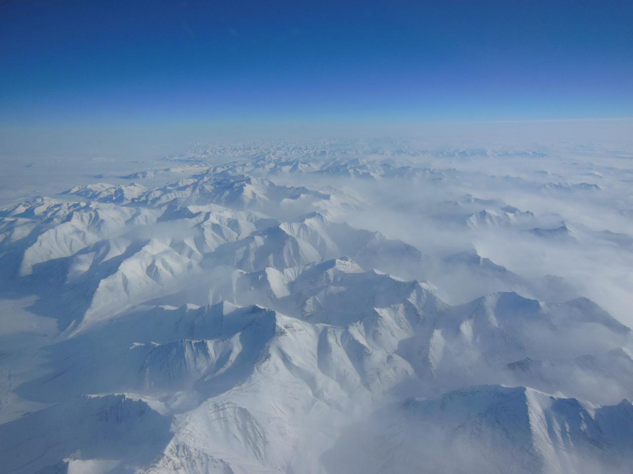
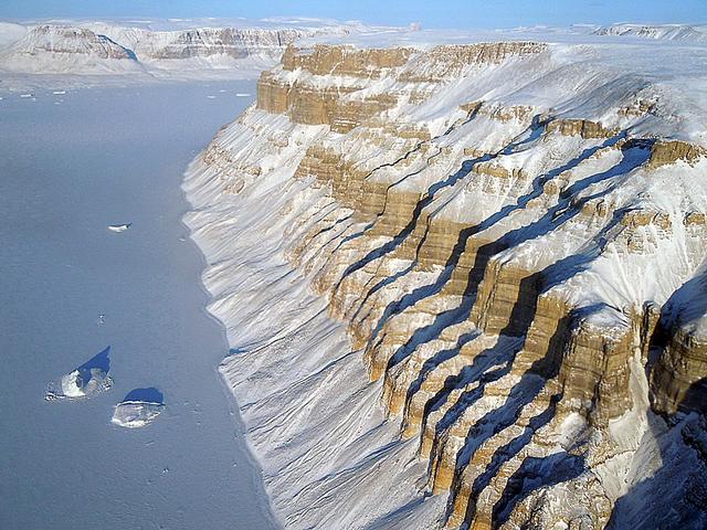
Alaskan mountains seen from high altitude aboard the NASA P-3B during the IceBridge transit flight from Thule to Fairbanks on Mar. 21, 2013. NASA's Operation IceBridge is an airborne science mission to study Earth's polar ice. For more information about IceBridge, visit: <a href="http://www.nasa.gov/icebridge" rel="nofollow">www.nasa.gov/icebridge</a> Credit: NASA/Goddard/Christy Hansen <b><a href="http://www.nasa.gov/audience/formedia/features/MP_Photo_Guidelines.html" rel="nofollow">NASA image use policy.</a></b> <b><a href="http://www.nasa.gov/centers/goddard/home/index.html" rel="nofollow">NASA Goddard Space Flight Center</a></b> enables NASA’s mission through four scientific endeavors: Earth Science, Heliophysics, Solar System Exploration, and Astrophysics. Goddard plays a leading role in NASA’s accomplishments by contributing compelling scientific knowledge to advance the Agency’s mission. <b>Follow us on <a href="http://twitter.com/NASA_GoddardPix" rel="nofollow">Twitter</a></b> <b>Like us on <a href="http://www.facebook.com/pages/Greenbelt-MD/NASA-Goddard/395013845897?ref=tsd" rel="nofollow">Facebook</a></b> <b>Find us on <a href="http://instagram.com/nasagoddard?vm=grid" rel="nofollow">Instagram</a></b>
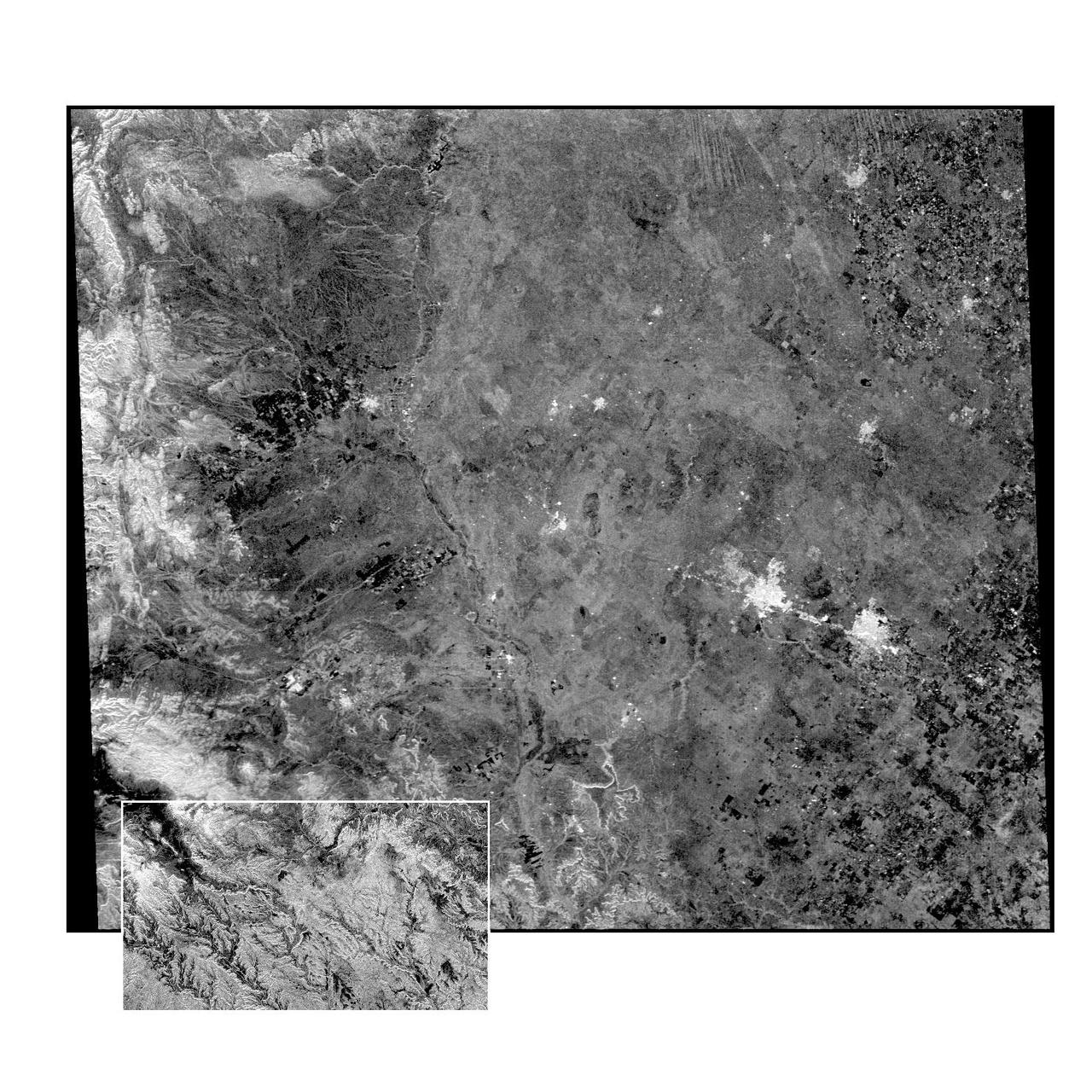
This radar image of the Midland/Odessa region of West Texas, demonstrates an experimental technique, called ScanSAR, that allows scientists to rapidly image large areas of the Earth's surface. The large image covers an area 245 kilometers by 225 kilometers (152 miles by 139 miles). It was obtained by the Spaceborne Imaging Radar-C/X-Band Synthetic Aperture Radar (SIR-C/X-SAR) flying aboard the space shuttle Endeavour on October 5, 1994. The smaller inset image is a standard SIR-C image showing a portion of the same area, 100 kilometers by 57 kilometers (62 miles by 35 miles) and was taken during the first flight of SIR-C on April 14, 1994. The bright spots on the right side of the image are the cities of Odessa (left) and Midland (right), Texas. The Pecos River runs from the top center to the bottom center of the image. Along the left side of the image are, from top to bottom, parts of the Guadalupe, Davis and Santiago Mountains. North is toward the upper right. Unlike conventional radar imaging, in which a radar continuously illuminates a single ground swath as the space shuttle passes over the terrain, a Scansar radar illuminates several adjacent ground swaths almost simultaneously, by "scanning" the radar beam across a large area in a rapid sequence. The adjacent swaths, typically about 50 km (31 miles) wide, are then merged during ground processing to produce a single large scene. Illumination for this L-band scene is from the top of the image. The beams were scanned from the top of the scene to the bottom, as the shuttle flew from left to right. This scene was acquired in about 30 seconds. A normal SIR-C image is acquired in about 13 seconds. The ScanSAR mode will likely be used on future radar sensors to construct regional and possibly global radar images and topographic maps. The ScanSAR processor is being designed for 1996 implementation at NASA's Alaska SAR Facility, located at the University of Alaska Fairbanks, and will produce digital images from the forthcoming Canadian RADARSAT satellite. http://photojournal.jpl.nasa.gov/catalog/PIA01787
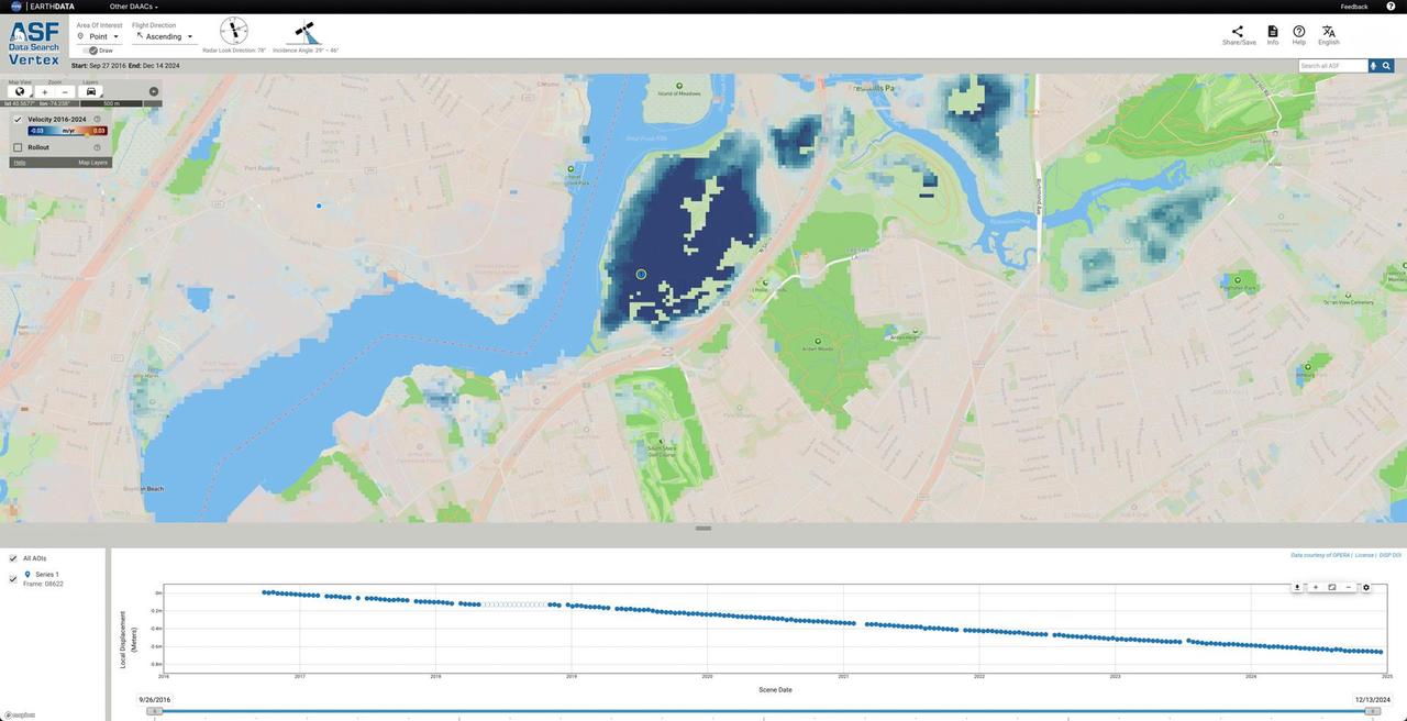
NASA, along with the agency's Jet Propulsion Laboratory in Southern California, is collaborating with the Alaska Satellite Facility in Fairbanks to create a powerful web-based tool that will show the movement of land across North America down to less than an inch. The online portal and its underlying dataset unlock a trove of satellite radar measurements that can help anyone identify where and by how much the land beneath their feet may be moving – whether from earthquakes, volcanoes, landslides, or the extraction of underground natural resources such as groundwater. Spearheaded by NASA's Observational Products for End-Users from Remote Sensing Analysis, or OPERA, project at JPL, the effort equips users with information that would otherwise take years of training to harness. The project builds on data from spaceborne synthetic aperture radars, or SARs, to generate high-resolution data on how Earth's surface is moving. Formally called the North America Surface Displacement Product Suite, the new dataset dates to 2016. By the end of 2025, the data will cover the entire United States, Central America, and Canada within 120 miles (200 kilometers) of the U.S. border. The image shows how the portal visualizes land sinking over time in Freshkills Park, which is being built on a former landfill on Staten Island, New York. Landfills tend to sink over time as waste decomposes, compacts, and settles under its own weight. The blue dot marks the point on the land where the portal is displaying movement in the accompanying scatterplot. https://photojournal.jpl.nasa.gov/catalog/PIA26494
On March 31, the P-3 departed Thule, Greenland. IceBridge teams flew a science transit flight to Kangerlussaq, Greenland, where missions will be based for the next several weeks before returning to Thule. Along the route, instruments surveyed several targets of opportunity including two ground tracks of the Ice, Cloud and land Elevation Satellite (ICESat) and several glaciers (Rink, Kangerdlugssuaq, Jakobshavn and Russell), turning up great data and spectacular views. March 29 was another perfect day for a land ice flight. The P-3 flew between deep canyons and over glaciers along the northwest coast of Greenland. But before the start of land ice flights, IceBridge reached a key milestone over sea ice. On March 28, IceBridge flew its eighth sea ice flight marking the completion of all high- and medium-priority sea ice missions planned from Thule. Among the sea ice missions was a science transit back from Fairbanks to Thule on March 25, during which the P-3 surveyed in complete darkness. Researchers watched the scanning pattern of the green lasers on the sea ice below and the beautiful Aurora Borealis above. To learn more about Ice Bridge go to: <a href="http://www.nasa.gov/mission_pages/icebridge/news/spr11/index.html" rel="nofollow">www.nasa.gov/mission_pages/icebridge/news/spr11/index.html</a> <b><a href="http://www.nasa.gov/centers/goddard/home/index.html" rel="nofollow">NASA Goddard Space Flight Center</a></b> enables NASA’s mission through four scientific endeavors: Earth Science, Heliophysics, Solar System Exploration, and Astrophysics. Goddard plays a leading role in NASA’s accomplishments by contributing compelling scientific knowledge to advance the Agency’s mission. <b>Follow us on <a href="http://twitter.com/NASA_GoddardPix" rel="nofollow">Twitter</a></b> <b>Join us on <a href="http://www.facebook.com/pages/Greenbelt-MD/NASA-Goddard/395013845897?ref=tsd" rel="nofollow">Facebook</a></b>
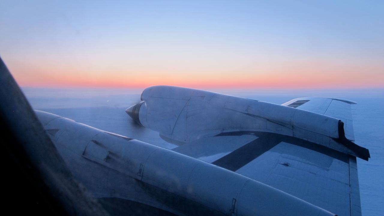
View just before sunrise over the Arctic Ocean during IceBridge's transit flight from Fairbanks to Thule on Mar. 26, 2013. IceBridge has flown the same path across the Arctic Basin in each Arctic campaign, allowing researchers to measure differences in ice thickness the entire way and build a reliable year-to-year record of change. NASA's Operation IceBridge is an airborne science mission to study Earth's polar ice. For more information about IceBridge, visit: <a href="http://www.nasa.gov/icebridge" rel="nofollow">www.nasa.gov/icebridge</a> Credit: NASA/Jim Yungel <b><a href="http://www.nasa.gov/audience/formedia/features/MP_Photo_Guidelines.html" rel="nofollow">NASA image use policy.</a></b> <b><a href="http://www.nasa.gov/centers/goddard/home/index.html" rel="nofollow">NASA Goddard Space Flight Center</a></b> enables NASA’s mission through four scientific endeavors: Earth Science, Heliophysics, Solar System Exploration, and Astrophysics. Goddard plays a leading role in NASA’s accomplishments by contributing compelling scientific knowledge to advance the Agency’s mission. <b>Follow us on <a href="http://twitter.com/NASA_GoddardPix" rel="nofollow">Twitter</a></b> <b>Like us on <a href="http://www.facebook.com/pages/Greenbelt-MD/NASA-Goddard/395013845897?ref=tsd" rel="nofollow">Facebook</a></b> <b>Find us on <a href="http://instagram.com/nasagoddard?vm=grid" rel="nofollow">Instagram</a></b>
The NASA-funded Ground-to-Rocket Electron-Electrodynamics Correlative Experiment, or GREECE, wants to understand aurora. Specifically, it will study classic auroral curls that swirl through the sky like cream in a cup of coffee. The GREECE instruments travel on a sounding rocket that launches for a ten-minute ride right through the heart of the aurora reaching its zenith over the native village of Venetie, Alaska. To study the curl structures, GREECE consists of two parts: ground-based imagers located in Venetie to track the aurora from the ground and the rocket to take measurements from the middle of the aurora itself. At their simplest, auroras are caused when particles from the sun funnel over to Earth's night side, generate electric currents, and trigger a shower of particles that strike oxygen and nitrogen some 60 to 200 miles up in Earth's atmosphere, releasing a flash of light. But the details are always more complicated, of course. Researchers wish to understand the aurora, and movement of plasma in general, at much smaller scales including such things as how different structures are formed there. This is a piece of information, which in turn, helps paint a picture of the sun-Earth connection and how energy and particles from the sun interact with Earth's own magnetic system, the magnetosphere. GREECE is a collaborative effort between SWRI, which developed particle instruments and the ground-based imaging, and the University of California, Berkeley, measuring the electric and magnetic fields. The launch is supported by a sounding rocket team from NASA’s Wallops Flight Facility, Wallops Island, Va. The Poker Flat Research Range is operated by the University of Alaska, Fairbanks. Credit: NASA Goddard <b><a href="http://www.nasa.gov/audience/formedia/features/MP_Photo_Guidelines.html" rel="nofollow">NASA image use policy.</a></b> <b><a href="http://www.nasa.gov/centers/goddard/home/index.html" rel="nofollow">NASA Goddard Space Flight Center</a></b> enables NASA’s mission through four scientific endeavors: Earth Science, Heliophysics, Solar System Exploration, and Astrophysics. Goddard plays a leading role in NASA’s accomplishments by contributing compelling scientific knowledge to advance the Agency’s mission. <b>Follow us on <a href="http://twitter.com/NASAGoddardPix" rel="nofollow">Twitter</a></b> <b>Like us on <a href="http://www.facebook.com/pages/Greenbelt-MD/NASA-Goddard/395013845897?ref=tsd" rel="nofollow">Facebook</a></b> <b>Find us on <a href="http://instagram.com/nasagoddard?vm=grid" rel="nofollow">Instagram</a></b>
The NASA-funded Ground-to-Rocket Electron-Electrodynamics Correlative Experiment, or GREECE, wants to understand aurora. Specifically, it will study classic auroral curls that swirl through the sky like cream in a cup of coffee. The GREECE instruments travel on a sounding rocket that launches for a ten-minute ride right through the heart of the aurora reaching its zenith over the native village of Venetie, Alaska. To study the curl structures, GREECE consists of two parts: ground-based imagers located in Venetie to track the aurora from the ground and the rocket to take measurements from the middle of the aurora itself. At their simplest, auroras are caused when particles from the sun funnel over to Earth's night side, generate electric currents, and trigger a shower of particles that strike oxygen and nitrogen some 60 to 200 miles up in Earth's atmosphere, releasing a flash of light. But the details are always more complicated, of course. Researchers wish to understand the aurora, and movement of plasma in general, at much smaller scales including such things as how different structures are formed there. This is a piece of information, which in turn, helps paint a picture of the sun-Earth connection and how energy and particles from the sun interact with Earth's own magnetic system, the magnetosphere. GREECE is a collaborative effort between SWRI, which developed particle instruments and the ground-based imaging, and the University of California, Berkeley, measuring the electric and magnetic fields. The launch is supported by a sounding rocket team from NASA’s Wallops Flight Facility, Wallops Island, Va. The Poker Flat Research Range is operated by the University of Alaska, Fairbanks. Credit: NASA Goddard <b><a href="http://www.nasa.gov/audience/formedia/features/MP_Photo_Guidelines.html" rel="nofollow">NASA image use policy.</a></b> <b><a href="http://www.nasa.gov/centers/goddard/home/index.html" rel="nofollow">NASA Goddard Space Flight Center</a></b> enables NASA’s mission through four scientific endeavors: Earth Science, Heliophysics, Solar System Exploration, and Astrophysics. Goddard plays a leading role in NASA’s accomplishments by contributing compelling scientific knowledge to advance the Agency’s mission. <b>Follow us on <a href="http://twitter.com/NASAGoddardPix" rel="nofollow">Twitter</a></b> <b>Like us on <a href="http://www.facebook.com/pages/Greenbelt-MD/NASA-Goddard/395013845897?ref=tsd" rel="nofollow">Facebook</a></b> <b>Find us on <a href="http://instagram.com/nasagoddard?vm=grid" rel="nofollow">Instagram</a></b>
The NASA-funded Ground-to-Rocket Electron-Electrodynamics Correlative Experiment, or GREECE, wants to understand aurora. Specifically, it will study classic auroral curls that swirl through the sky like cream in a cup of coffee. The GREECE instruments travel on a sounding rocket that launches for a ten-minute ride right through the heart of the aurora reaching its zenith over the native village of Venetie, Alaska. To study the curl structures, GREECE consists of two parts: ground-based imagers located in Venetie to track the aurora from the ground and the rocket to take measurements from the middle of the aurora itself. At their simplest, auroras are caused when particles from the sun funnel over to Earth's night side, generate electric currents, and trigger a shower of particles that strike oxygen and nitrogen some 60 to 200 miles up in Earth's atmosphere, releasing a flash of light. But the details are always more complicated, of course. Researchers wish to understand the aurora, and movement of plasma in general, at much smaller scales including such things as how different structures are formed there. This is a piece of information, which in turn, helps paint a picture of the sun-Earth connection and how energy and particles from the sun interact with Earth's own magnetic system, the magnetosphere. GREECE is a collaborative effort between SWRI, which developed particle instruments and the ground-based imaging, and the University of California, Berkeley, measuring the electric and magnetic fields. The launch is supported by a sounding rocket team from NASA’s Wallops Flight Facility, Wallops Island, Va. The Poker Flat Research Range is operated by the University of Alaska, Fairbanks. Credit: NASA Goddard <b><a href="http://www.nasa.gov/audience/formedia/features/MP_Photo_Guidelines.html" rel="nofollow">NASA image use policy.</a></b> <b><a href="http://www.nasa.gov/centers/goddard/home/index.html" rel="nofollow">NASA Goddard Space Flight Center</a></b> enables NASA’s mission through four scientific endeavors: Earth Science, Heliophysics, Solar System Exploration, and Astrophysics. Goddard plays a leading role in NASA’s accomplishments by contributing compelling scientific knowledge to advance the Agency’s mission. <b>Follow us on <a href="http://twitter.com/NASAGoddardPix" rel="nofollow">Twitter</a></b> <b>Like us on <a href="http://www.facebook.com/pages/Greenbelt-MD/NASA-Goddard/395013845897?ref=tsd" rel="nofollow">Facebook</a></b> <b>Find us on <a href="http://instagram.com/nasagoddard?vm=grid" rel="nofollow">Instagram</a></b>
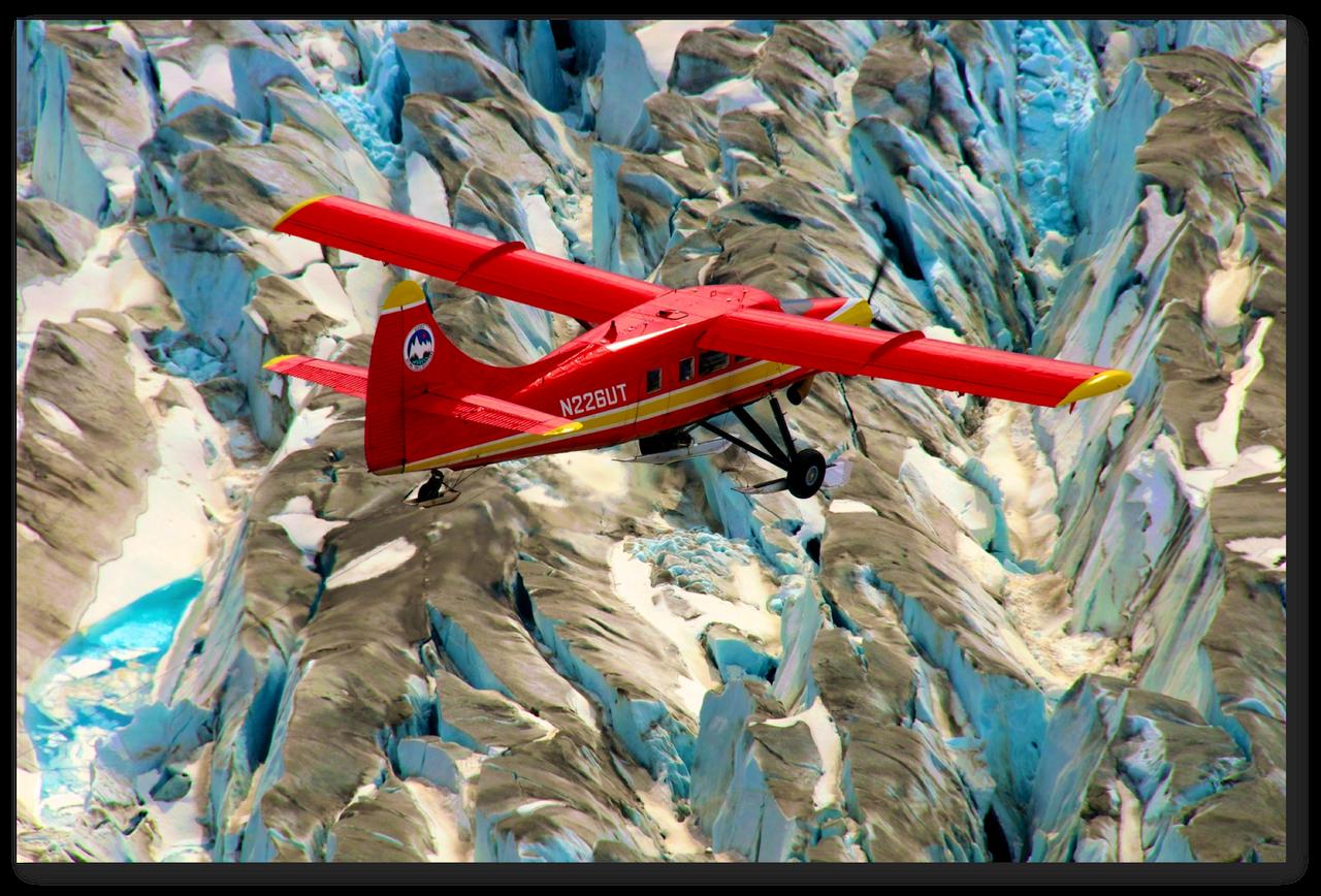
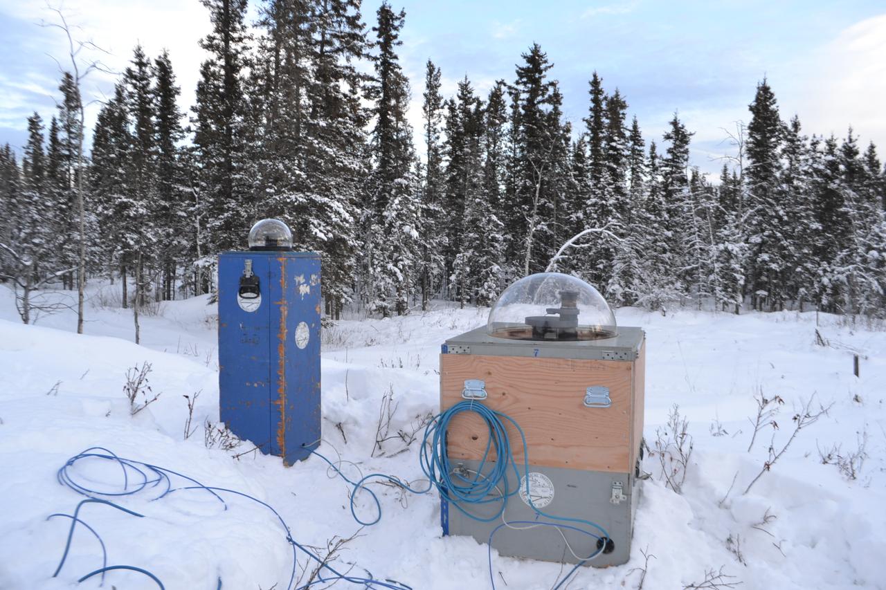
This red plane is a DHC-3 Otter, the plane flown in NASA's Operation IceBridge-Alaska surveys of mountain glaciers in Alaska. Credit: Chris Larsen, University of Alaska-Fairbanks Over the past few decades, average global temperatures have been on the rise, and this warming is happening two to three times faster in the Arctic. As the region’s summer comes to a close, NASA is hard at work studying how rising temperatures are affecting the Arctic. NASA researchers this summer and fall are carrying out three Alaska-based airborne research campaigns aimed at measuring greenhouse gas concentrations near Earth’s surface, monitoring Alaskan glaciers, and collecting data on Arctic sea ice and clouds. Observations from these NASA campaigns will give researchers a better understanding of how the Arctic is responding to rising temperatures. The Arctic Radiation – IceBridge Sea and Ice Experiment, or ARISE, is a new NASA airborne campaign to collect data on thinning sea ice and measure cloud and atmospheric properties in the Arctic. The campaign was designed to address questions about the relationship between retreating sea ice and the Arctic climate. Arctic sea ice reflects sunlight away from Earth, moderating warming in the region. Loss of sea ice means more heat from the sun is absorbed by the ocean surface, adding to Arctic warming. In addition, the larger amount of open water leads to more moisture in the air, which affects the formation of clouds that have their own effect on warming, either enhancing or reducing it. Read more: <a href="http://www.nasa.gov/earthrightnow" rel="nofollow">www.nasa.gov/earthrightnow</a> <b><a href="http://www.nasa.gov/audience/formedia/features/MP_Photo_Guidelines.html" rel="nofollow">NASA image use policy.</a></b> <b><a href="http://www.nasa.gov/centers/goddard/home/index.html" rel="nofollow">NASA Goddard Space Flight Center</a></b> enables NASA’s mission through four scientific endeavors: Earth Science, Heliophysics, Solar System Exploration, and Astrophysics. Goddard plays a leading role in NASA’s accomplishments by contributing compelling scientific knowledge to advance the Agency’s mission. <b>Follow us on <a href="http://twitter.com/NASAGoddardPix" rel="nofollow">Twitter</a></b> <b>Like us on <a href="http://www.facebook.com/pages/Greenbelt-MD/NASA-Goddard/395013845897?ref=tsd" rel="nofollow">Facebook</a></b> <b>Find us on <a href="http://instagram.com/nasagoddard?vm=grid" rel="nofollow">Instagram</a></b>

Caption: A NASA-funded sounding rocket launches into an aurora in the early morning of March 3, 2014, over Venetie, Alaska. The GREECE mission studies how certain structures – classic curls like swirls of cream in coffee -- form in the aurora. Credit: NASA/Christopher Perry More info: On March 3, 2014, at 6:09 a.m. EST, a NASA-funded sounding rocket launched straight into an aurora over Venetie, Alaska. The Ground-to-Rocket Electrodynamics – Electron Correlative Experiment, or GREECE, sounding rocket mission, which launched from Poker Flat Research Range in Poker Flat, Alaska, will study classic curls in the aurora in the night sky. The GREECE instruments travel on a sounding rocket that launches for a ten-minute ride right through the heart of the aurora reaching its zenith over the native village of Venetie, Alaska. To study the curl structures, GREECE consists of two parts: ground-based imagers located in Venetie to track the aurora from the ground and the rocket to take measurements from the middle of the aurora itself. At their simplest, auroras are caused when particles from the sun funnel over to Earth's night side, generate electric currents, and trigger a shower of particles that strike oxygen and nitrogen some 60 to 200 miles up in Earth's atmosphere, releasing a flash of light. But the details are always more complicated, of course. Researchers wish to understand the aurora, and movement of plasma in general, at much smaller scales including such things as how different structures are formed there. This is a piece of information, which in turn, helps paint a picture of the sun-Earth connection and how energy and particles from the sun interact with Earth's own magnetic system, the magnetosphere. GREECE is a collaborative effort between SWRI, which developed particle instruments and the ground-based imaging, and the University of California, Berkeley, measuring the electric and magnetic fields. The launch is supported by a sounding rocket team from NASA’s Wallops Flight Facility, Wallops Island, Va. The Poker Flat Research Range is operated by the University of Alaska, Fairbanks. “The conditions were optimal,” said Marilia Samara, principal investigator for the mission at Southwest Research Institute in San Antonio, Texas. “We can’t wait to dig into the data.” For more information on the GREECE mission visit: <a href="http://www.nasa.gov/content/goddard/nasa-funded-sounding-rocket-to-catch-aurora-in-the-act/." rel="nofollow">www.nasa.gov/content/goddard/nasa-funded-sounding-rocket- </a>.<b><a href="http://www.nasa.gov/audience/formedia/features/MP_Photo_Guidelines.html" rel="nofollow">NASA image use policy.</a></b> <b><a href="http://www.nasa.gov/centers/goddard/home/index.html" rel="nofollow">NASA Goddard Space Flight Center</a></b> enables NASA’s mission through four scientific endeavors: Earth Science, Heliophysics, Solar System Exploration, and Astrophysics. Goddard plays a leading role in NASA’s accomplishments by contributing compelling scientific knowledge to advance the Agency’s mission. <b>Follow us on <a href="http://twitter.com/NASAGoddardPix" rel="nofollow">Twitter</a></b> <b>Like us on <a href="http://www.facebook.com/pages/Greenbelt-MD/NASA-Goddard/395013845897?ref=tsd" rel="nofollow">Facebook</a></b> <b>Find us on <a href="http://instagram.com/nasagoddard?vm=grid" rel="nofollow">Instagram</a></b>

Caption: A NASA-funded sounding rocket launches into an aurora in the early morning of March 3, 2014, over Venetie, Alaska. The GREECE mission studies how certain structures – classic curls like swirls of cream in coffee -- form in the aurora. Credit: NASA/Christopher Perry More info: On March 3, 2014, at 6:09 a.m. EST, a NASA-funded sounding rocket launched straight into an aurora over Venetie, Alaska. The Ground-to-Rocket Electrodynamics – Electron Correlative Experiment, or GREECE, sounding rocket mission, which launched from Poker Flat Research Range in Poker Flat, Alaska, will study classic curls in the aurora in the night sky. The GREECE instruments travel on a sounding rocket that launches for a ten-minute ride right through the heart of the aurora reaching its zenith over the native village of Venetie, Alaska. To study the curl structures, GREECE consists of two parts: ground-based imagers located in Venetie to track the aurora from the ground and the rocket to take measurements from the middle of the aurora itself. At their simplest, auroras are caused when particles from the sun funnel over to Earth's night side, generate electric currents, and trigger a shower of particles that strike oxygen and nitrogen some 60 to 200 miles up in Earth's atmosphere, releasing a flash of light. But the details are always more complicated, of course. Researchers wish to understand the aurora, and movement of plasma in general, at much smaller scales including such things as how different structures are formed there. This is a piece of information, which in turn, helps paint a picture of the sun-Earth connection and how energy and particles from the sun interact with Earth's own magnetic system, the magnetosphere. GREECE is a collaborative effort between SWRI, which developed particle instruments and the ground-based imaging, and the University of California, Berkeley, measuring the electric and magnetic fields. The launch is supported by a sounding rocket team from NASA’s Wallops Flight Facility, Wallops Island, Va. The Poker Flat Research Range is operated by the University of Alaska, Fairbanks. “The conditions were optimal,” said Marilia Samara, principal investigator for the mission at Southwest Research Institute in San Antonio, Texas. “We can’t wait to dig into the data.” For more information on the GREECE mission visit: <a href="http://www.nasa.gov/content/goddard/nasa-funded-sounding-rocket-to-catch-aurora-in-the-act/." rel="nofollow">www.nasa.gov/content/goddard/nasa-funded-sounding-rocket- </a>.<b><a href="http://www.nasa.gov/audience/formedia/features/MP_Photo_Guidelines.html" rel="nofollow">NASA image use policy.</a></b> <b><a href="http://www.nasa.gov/centers/goddard/home/index.html" rel="nofollow">NASA Goddard Space Flight Center</a></b> enables NASA’s mission through four scientific endeavors: Earth Science, Heliophysics, Solar System Exploration, and Astrophysics. Goddard plays a leading role in NASA’s accomplishments by contributing compelling scientific knowledge to advance the Agency’s mission. <b>Follow us on <a href="http://twitter.com/NASAGoddardPix" rel="nofollow">Twitter</a></b> <b>Like us on <a href="http://www.facebook.com/pages/Greenbelt-MD/NASA-Goddard/395013845897?ref=tsd" rel="nofollow">Facebook</a></b> <b>Find us on <a href="http://instagram.com/nasagoddard?vm=grid" rel="nofollow">Instagram</a></b>

Caption: A NASA-funded sounding rocket launches into an aurora in the early morning of March 3, 2014, over Venetie, Alaska. The GREECE mission studies how certain structures – classic curls like swirls of cream in coffee -- form in the aurora. Credit: NASA/Christopher Perry More info: On March 3, 2014, at 6:09 a.m. EST, a NASA-funded sounding rocket launched straight into an aurora over Venetie, Alaska. The Ground-to-Rocket Electrodynamics – Electron Correlative Experiment, or GREECE, sounding rocket mission, which launched from Poker Flat Research Range in Poker Flat, Alaska, will study classic curls in the aurora in the night sky. The GREECE instruments travel on a sounding rocket that launches for a ten-minute ride right through the heart of the aurora reaching its zenith over the native village of Venetie, Alaska. To study the curl structures, GREECE consists of two parts: ground-based imagers located in Venetie to track the aurora from the ground and the rocket to take measurements from the middle of the aurora itself. At their simplest, auroras are caused when particles from the sun funnel over to Earth's night side, generate electric currents, and trigger a shower of particles that strike oxygen and nitrogen some 60 to 200 miles up in Earth's atmosphere, releasing a flash of light. But the details are always more complicated, of course. Researchers wish to understand the aurora, and movement of plasma in general, at much smaller scales including such things as how different structures are formed there. This is a piece of information, which in turn, helps paint a picture of the sun-Earth connection and how energy and particles from the sun interact with Earth's own magnetic system, the magnetosphere. GREECE is a collaborative effort between SWRI, which developed particle instruments and the ground-based imaging, and the University of California, Berkeley, measuring the electric and magnetic fields. The launch is supported by a sounding rocket team from NASA’s Wallops Flight Facility, Wallops Island, Va. The Poker Flat Research Range is operated by the University of Alaska, Fairbanks. “The conditions were optimal,” said Marilia Samara, principal investigator for the mission at Southwest Research Institute in San Antonio, Texas. “We can’t wait to dig into the data.” For more information on the GREECE mission visit: <a href="http://www.nasa.gov/content/goddard/nasa-funded-sounding-rocket-to-catch-aurora-in-the-act/." rel="nofollow">www.nasa.gov/content/goddard/nasa-funded-sounding-rocket- </a>.<b><a href="http://www.nasa.gov/audience/formedia/features/MP_Photo_Guidelines.html" rel="nofollow">NASA image use policy.</a></b> <b><a href="http://www.nasa.gov/centers/goddard/home/index.html" rel="nofollow">NASA Goddard Space Flight Center</a></b> enables NASA’s mission through four scientific endeavors: Earth Science, Heliophysics, Solar System Exploration, and Astrophysics. Goddard plays a leading role in NASA’s accomplishments by contributing compelling scientific knowledge to advance the Agency’s mission. <b>Follow us on <a href="http://twitter.com/NASAGoddardPix" rel="nofollow">Twitter</a></b> <b>Like us on <a href="http://www.facebook.com/pages/Greenbelt-MD/NASA-Goddard/395013845897?ref=tsd" rel="nofollow">Facebook</a></b> <b>Find us on <a href="http://instagram.com/nasagoddard?vm=grid" rel="nofollow">Instagram</a></b>

Caption: A NASA-funded sounding rocket launches into an aurora in the early morning of March 3, 2014, over Venetie, Alaska. The GREECE mission studies how certain structures – classic curls like swirls of cream in coffee -- form in the aurora. Credit: NASA/Christopher Perry More info: On March 3, 2014, at 6:09 a.m. EST, a NASA-funded sounding rocket launched straight into an aurora over Venetie, Alaska. The Ground-to-Rocket Electrodynamics – Electron Correlative Experiment, or GREECE, sounding rocket mission, which launched from Poker Flat Research Range in Poker Flat, Alaska, will study classic curls in the aurora in the night sky. The GREECE instruments travel on a sounding rocket that launches for a ten-minute ride right through the heart of the aurora reaching its zenith over the native village of Venetie, Alaska. To study the curl structures, GREECE consists of two parts: ground-based imagers located in Venetie to track the aurora from the ground and the rocket to take measurements from the middle of the aurora itself. At their simplest, auroras are caused when particles from the sun funnel over to Earth's night side, generate electric currents, and trigger a shower of particles that strike oxygen and nitrogen some 60 to 200 miles up in Earth's atmosphere, releasing a flash of light. But the details are always more complicated, of course. Researchers wish to understand the aurora, and movement of plasma in general, at much smaller scales including such things as how different structures are formed there. This is a piece of information, which in turn, helps paint a picture of the sun-Earth connection and how energy and particles from the sun interact with Earth's own magnetic system, the magnetosphere. GREECE is a collaborative effort between SWRI, which developed particle instruments and the ground-based imaging, and the University of California, Berkeley, measuring the electric and magnetic fields. The launch is supported by a sounding rocket team from NASA’s Wallops Flight Facility, Wallops Island, Va. The Poker Flat Research Range is operated by the University of Alaska, Fairbanks. “The conditions were optimal,” said Marilia Samara, principal investigator for the mission at Southwest Research Institute in San Antonio, Texas. “We can’t wait to dig into the data.” For more information on the GREECE mission visit: <a href="http://www.nasa.gov/content/goddard/nasa-funded-sounding-rocket-to-catch-aurora-in-the-act/." rel="nofollow">www.nasa.gov/content/goddard/nasa-funded-sounding-rocket- </a>.<b><a href="http://www.nasa.gov/audience/formedia/features/MP_Photo_Guidelines.html" rel="nofollow">NASA image use policy.</a></b> <b><a href="http://www.nasa.gov/centers/goddard/home/index.html" rel="nofollow">NASA Goddard Space Flight Center</a></b> enables NASA’s mission through four scientific endeavors: Earth Science, Heliophysics, Solar System Exploration, and Astrophysics. Goddard plays a leading role in NASA’s accomplishments by contributing compelling scientific knowledge to advance the Agency’s mission. <b>Follow us on <a href="http://twitter.com/NASAGoddardPix" rel="nofollow">Twitter</a></b> <b>Like us on <a href="http://www.facebook.com/pages/Greenbelt-MD/NASA-Goddard/395013845897?ref=tsd" rel="nofollow">Facebook</a></b> <b>Find us on <a href="http://instagram.com/nasagoddard?vm=grid" rel="nofollow">Instagram</a></b>

Caption: A NASA-funded sounding rocket launches into an aurora in the early morning of March 3, 2014, over Venetie, Alaska. The GREECE mission studies how certain structures – classic curls like swirls of cream in coffee -- form in the aurora. Credit: NASA/Christopher Perry More info: On March 3, 2014, at 6:09 a.m. EST, a NASA-funded sounding rocket launched straight into an aurora over Venetie, Alaska. The Ground-to-Rocket Electrodynamics – Electron Correlative Experiment, or GREECE, sounding rocket mission, which launched from Poker Flat Research Range in Poker Flat, Alaska, will study classic curls in the aurora in the night sky. The GREECE instruments travel on a sounding rocket that launches for a ten-minute ride right through the heart of the aurora reaching its zenith over the native village of Venetie, Alaska. To study the curl structures, GREECE consists of two parts: ground-based imagers located in Venetie to track the aurora from the ground and the rocket to take measurements from the middle of the aurora itself. At their simplest, auroras are caused when particles from the sun funnel over to Earth's night side, generate electric currents, and trigger a shower of particles that strike oxygen and nitrogen some 60 to 200 miles up in Earth's atmosphere, releasing a flash of light. But the details are always more complicated, of course. Researchers wish to understand the aurora, and movement of plasma in general, at much smaller scales including such things as how different structures are formed there. This is a piece of information, which in turn, helps paint a picture of the sun-Earth connection and how energy and particles from the sun interact with Earth's own magnetic system, the magnetosphere. GREECE is a collaborative effort between SWRI, which developed particle instruments and the ground-based imaging, and the University of California, Berkeley, measuring the electric and magnetic fields. The launch is supported by a sounding rocket team from NASA’s Wallops Flight Facility, Wallops Island, Va. The Poker Flat Research Range is operated by the University of Alaska, Fairbanks. “The conditions were optimal,” said Marilia Samara, principal investigator for the mission at Southwest Research Institute in San Antonio, Texas. “We can’t wait to dig into the data.” For more information on the GREECE mission visit: <a href="http://www.nasa.gov/content/goddard/nasa-funded-sounding-rocket-to-catch-aurora-in-the-act/." rel="nofollow">www.nasa.gov/content/goddard/nasa-funded-sounding-rocket- </a>.<b><a href="http://www.nasa.gov/audience/formedia/features/MP_Photo_Guidelines.html" rel="nofollow">NASA image use policy.</a></b> <b><a href="http://www.nasa.gov/centers/goddard/home/index.html" rel="nofollow">NASA Goddard Space Flight Center</a></b> enables NASA’s mission through four scientific endeavors: Earth Science, Heliophysics, Solar System Exploration, and Astrophysics. Goddard plays a leading role in NASA’s accomplishments by contributing compelling scientific knowledge to advance the Agency’s mission. <b>Follow us on <a href="http://twitter.com/NASAGoddardPix" rel="nofollow">Twitter</a></b> <b>Like us on <a href="http://www.facebook.com/pages/Greenbelt-MD/NASA-Goddard/395013845897?ref=tsd" rel="nofollow">Facebook</a></b> <b>Find us on <a href="http://instagram.com/nasagoddard?vm=grid" rel="nofollow">Instagram</a></b>
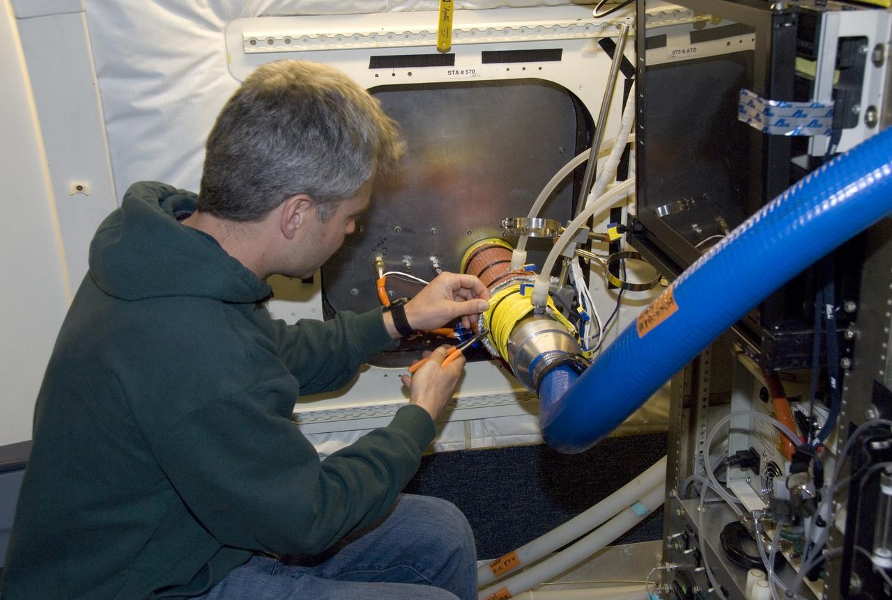
Climate researchers from the National Center for Atmospheric Research (NCAR) and several universities install and perform functional checkouts of a variety of sensitive atmospheric instruments on NASA's DC-8 airborne laboratory prior to beginning the ARCTAS mission.
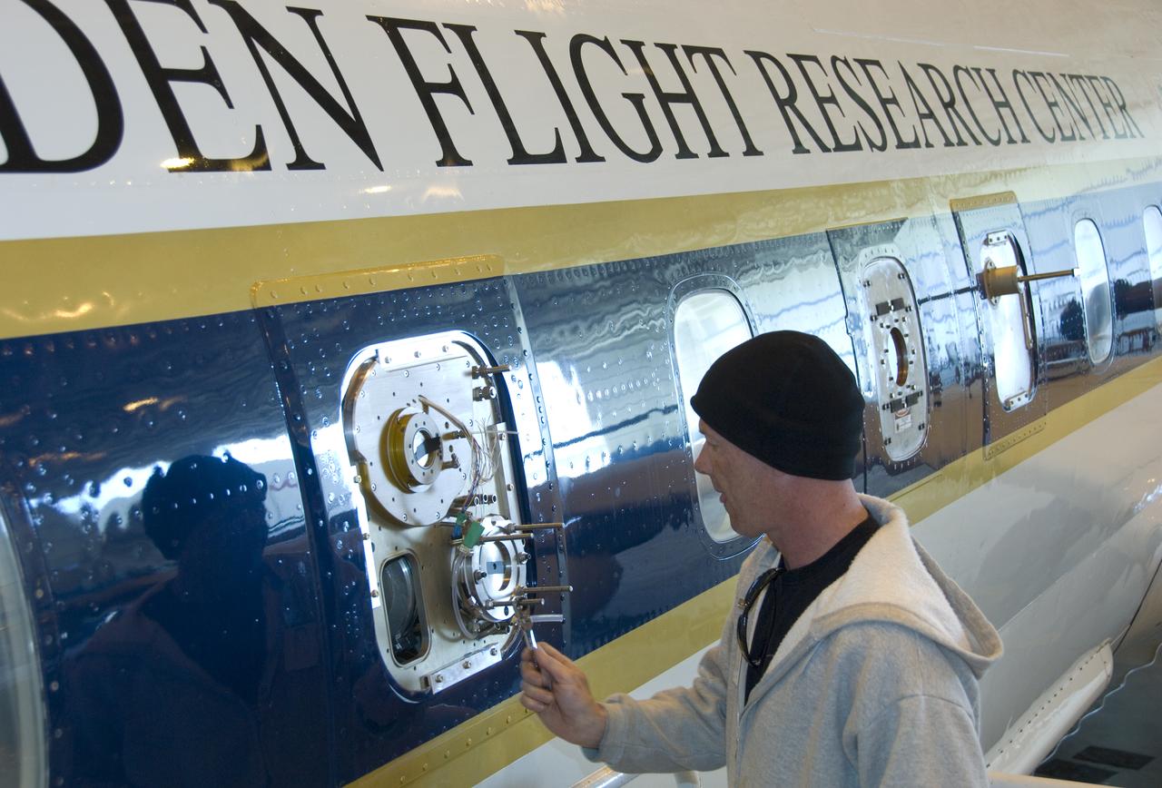
Climate researchers from the National Center for Atmospheric Research (NCAR) and several universities install and perform functional checkouts of a variety of sensitive atmospheric instruments on NASA's DC-8 airborne laboratory prior to beginning the ARCTAS mission.
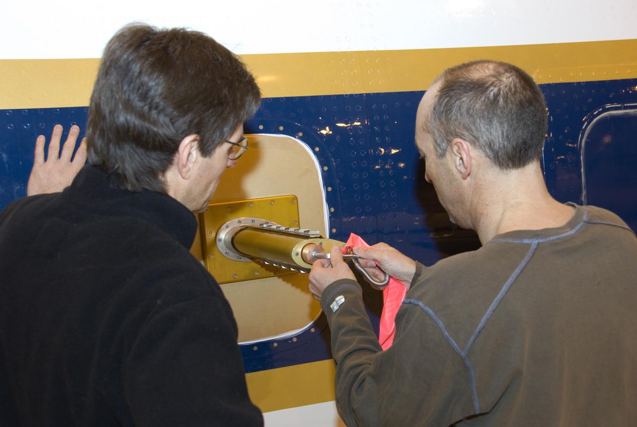
Climate researchers from the National Center for Atmospheric Research (NCAR) and several universities install and perform functional checkouts of a variety of sensitive atmospheric instruments on NASA's DC-8 airborne laboratory prior to beginning the ARCTAS mission.
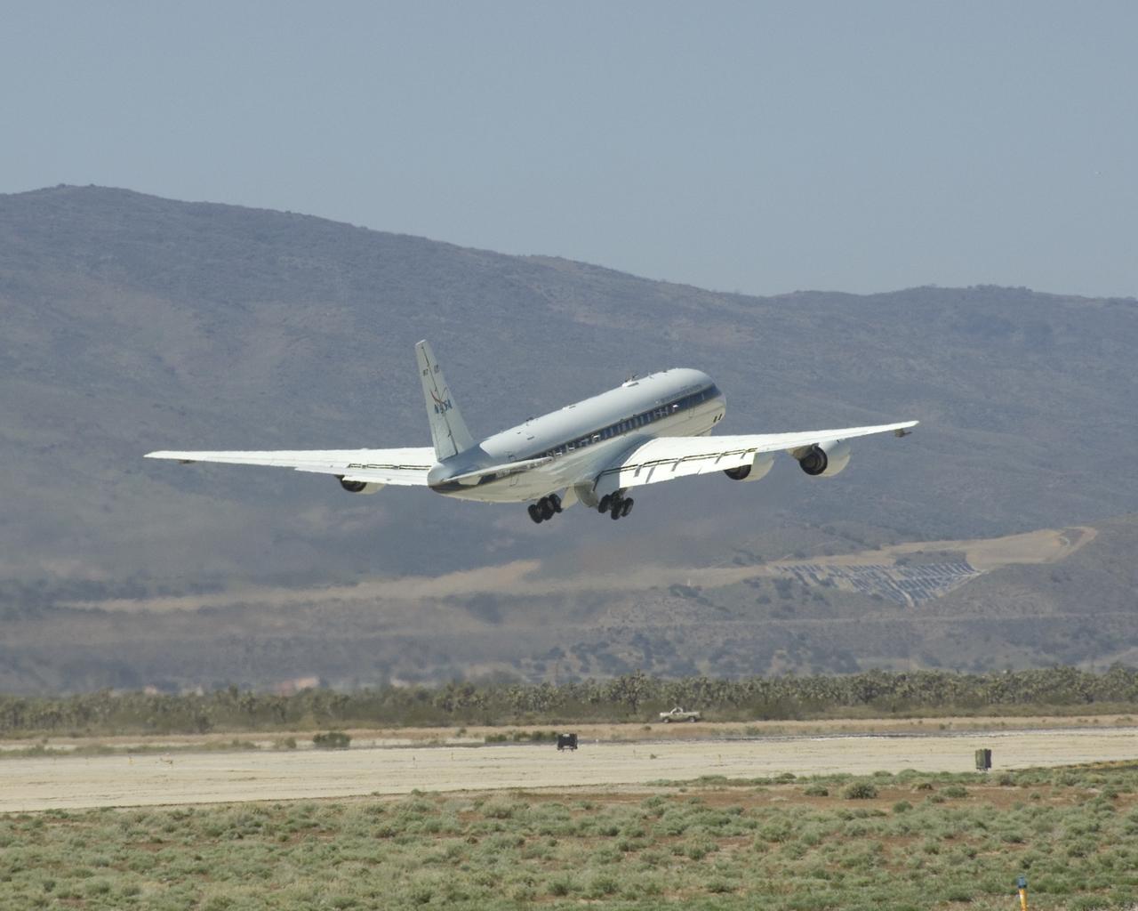
NASA's DC-8 flying laboratory lifts off the runway at Air Force Plant 42 in Palmdale, Calif., on its first flight in the ARCTAS atmospheric science mission.

Climate researchers from the National Center for Atmospheric Research (NCAR) and several universities install and perform functional checkouts of a variety of sensitive atmospheric instruments on NASA's DC-8 airborne laboratory prior to beginning the ARCTAS mission.

Climate researchers from the National Center for Atmospheric Research (NCAR) and several universities install and perform functional checkouts of a variety of sensitive atmospheric instruments on NASA's DC-8 airborne laboratory prior to beginning the ARCTAS mission.
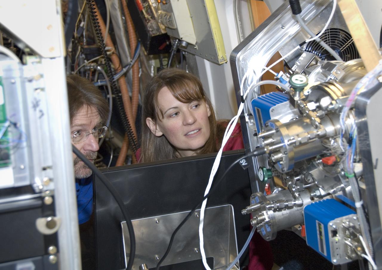
Climate researchers from the National Center for Atmospheric Research (NCAR) and several universities install and perform functional checkouts of a variety of sensitive atmospheric instruments on NASA's DC-8 airborne laboratory prior to beginning the ARCTAS mission.