
NASA employees enjoy the 2017 total solar eclipse in Idaho Falls, Idaho.

Juniper Doucette with her mother Chloe Doucette, head of education at the museum of Idaho Falls, celebrate the 2017 total solar eclipse.

The crowd at a NASA event during the 2017 total solar eclipse in Idaho Falls, Idaho
Wall Fall
Darkness Falls
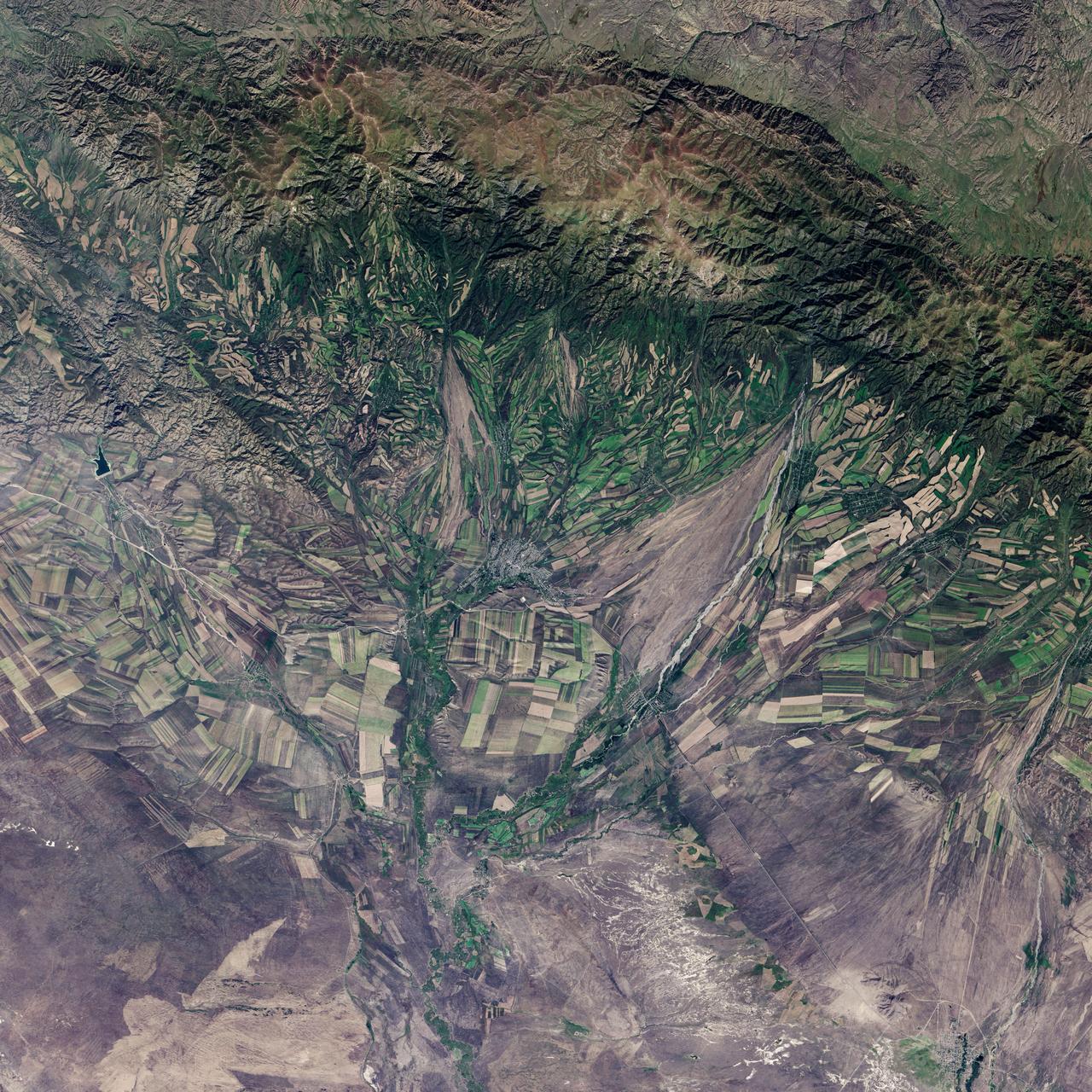
September 22, the autumnal equinox, marks the beginning of fall in the Northern Hemisphere, but the fall harvest begins early in the harsh continental climate of eastern Kazakhstan. By September 9, 2013, when the Operational Land Imager (OLI) on the Landsat 8 satellite acquired this image, several fields were already harvested and bare. Others were dark green with pasture grasses or ripening crops. The fields fill the contours of the land, running long and narrow down mountain valleys and spreading in large squares over the plains. Agriculture is an important segment of the economy in Kazakhstan: the country’s dry climate is ideal for producing high quality wheat for export. However, 61 percent of the country’s agricultural land is pasture for livestock. The area shown in this image, far eastern Kazakhstan near the Chinese border, is a minor wheat-growing region and may also produce sunflowers, barley, and other food crops. An artifact of Soviet-era collective farms, most of the farms in Kazakhstan are large, covering more than 5,000 hectares (12,500 acres). Some of the larger fields in the image reflect the big business side of agriculture. However, family farms and small agriculture businesses account for 35 percent of the country’s agricultural production, and some of these are visible as well, particularly in the uneven hills and mountains. Nearly all agriculture in Kazakhstan is rain fed. Farmers in this region have designed their fields to take advantage of rain flowing down hills, allowing the natural shape of the land to channel water to crops. The effect is a mosaic of green and tan with tones matching the natural vegetation in the mountains to the north. NASA Earth Observatory image by Jesse Allen using Landsat data from the U.S. Geological Survey. Caption by Holli Riebeek. Instrument: Landsat 8 - OLI More info: <a href="http://1.usa.gov/16IZ047" rel="nofollow">1.usa.gov/16IZ047</a> <b><a href="http://www.nasa.gov/audience/formedia/features/MP_Photo_Guidelines.html" rel="nofollow">NASA image use policy.</a></b> <b><a href="http://www.nasa.gov/centers/goddard/home/index.html" rel="nofollow">NASA Goddard Space Flight Center</a></b> enables NASA’s mission through four scientific endeavors: Earth Science, Heliophysics, Solar System Exploration, and Astrophysics. Goddard plays a leading role in NASA’s accomplishments by contributing compelling scientific knowledge to advance the Agency’s mission. <b>Follow us on <a href="http://twitter.com/NASA_GoddardPix" rel="nofollow">Twitter</a></b> <b>Like us on <a href="http://www.facebook.com/pages/Greenbelt-MD/NASA-Goddard/395013845897?ref=tsd" rel="nofollow">Facebook</a></b> <b>Find us on <a href="http://instagram.com/nasagoddard?vm=grid" rel="nofollow">Instagram</a></b>

2014 Fall Intern Orientation at NASA Ames Research Center.
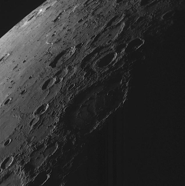
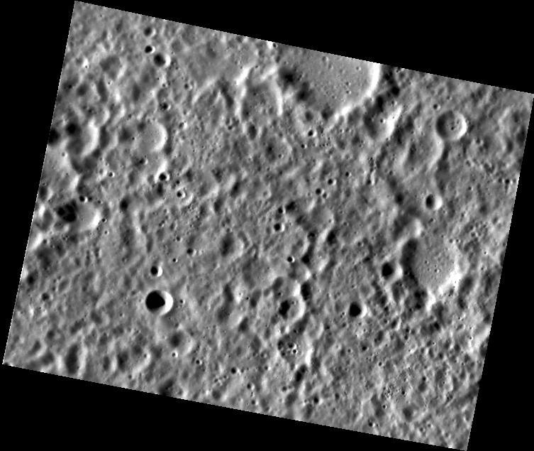
Night Falls on Mercury
A Hard Rain A-Gonna Fall
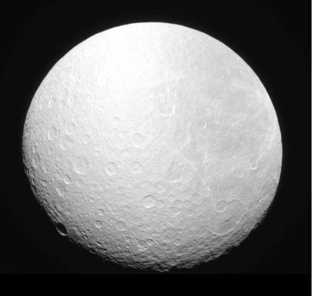
Darkness Falls on Rhea

SEASONAL VIEWS, FALL, (NOVEMBER 13, 2019), OF MSFC BUILDING 4200
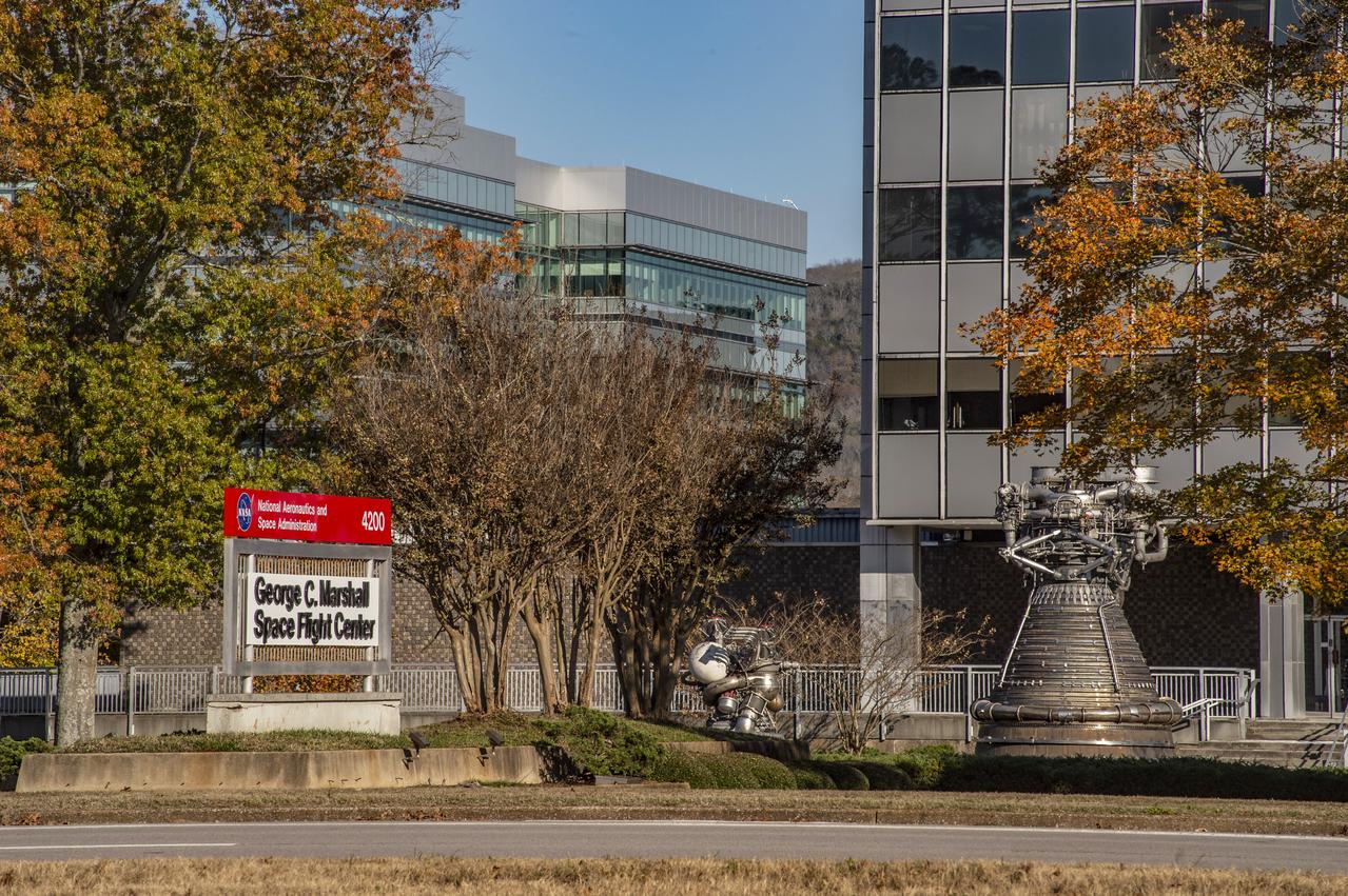
SEASONAL VIEWS, FALL, (NOVEMBER 13, 2019), OF MSFC BUILDING 4200
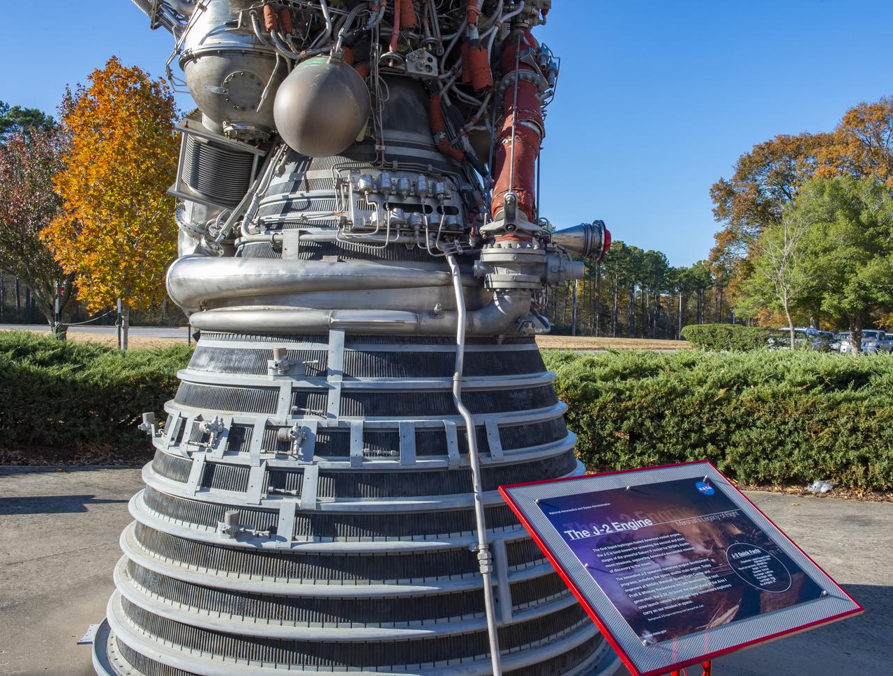
SEASONAL VIEWS, FALL, (NOVEMBER 13, 2019), OF MSFC BUILDING 4200
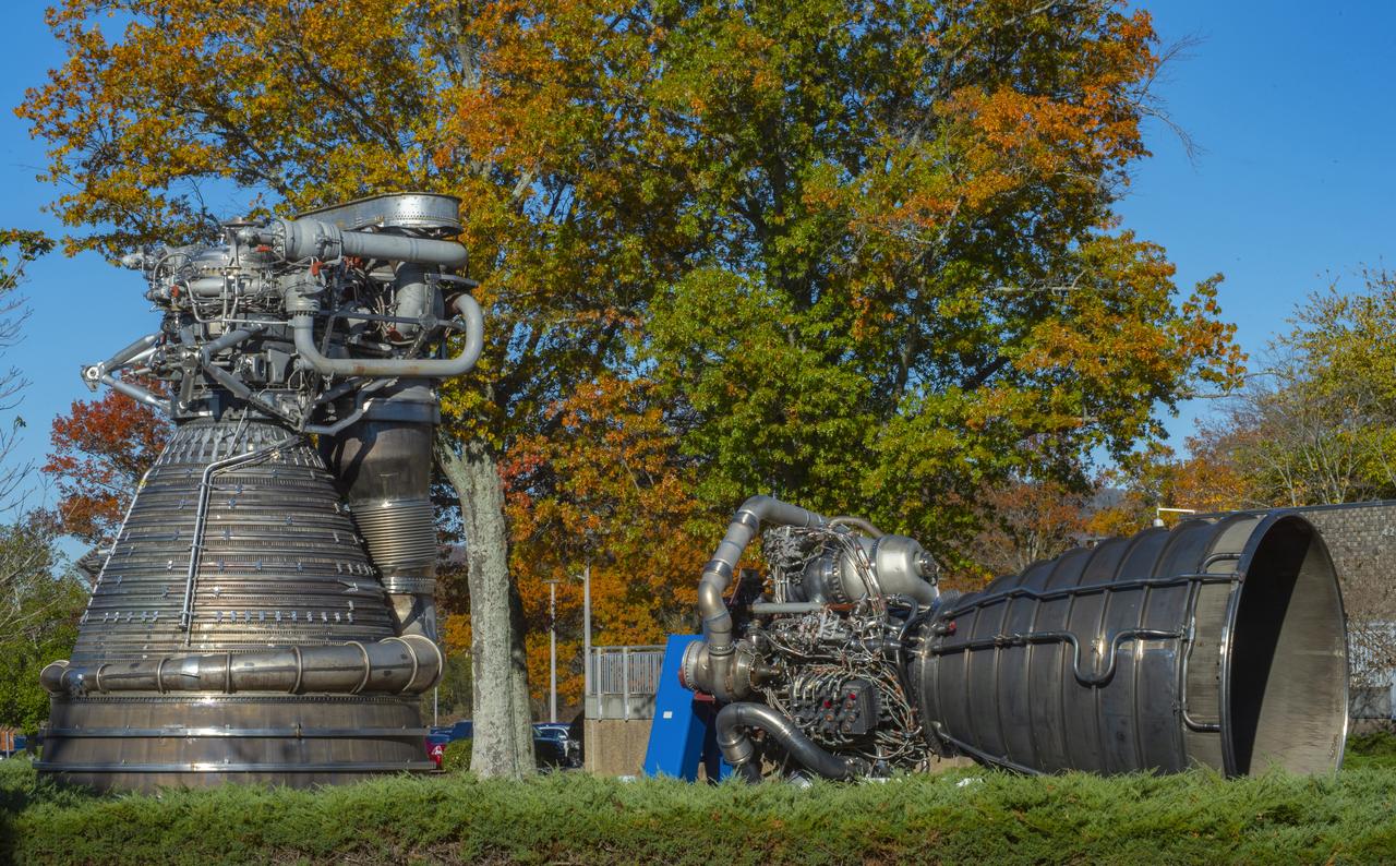
SEASONAL VIEWS, FALL, (NOVEMBER 13, 2019), OF MSFC BUILDING 4200

SEASONAL VIEWS, FALL, (NOVEMBER 13, 2019), OF MSFC BUILDING 4200
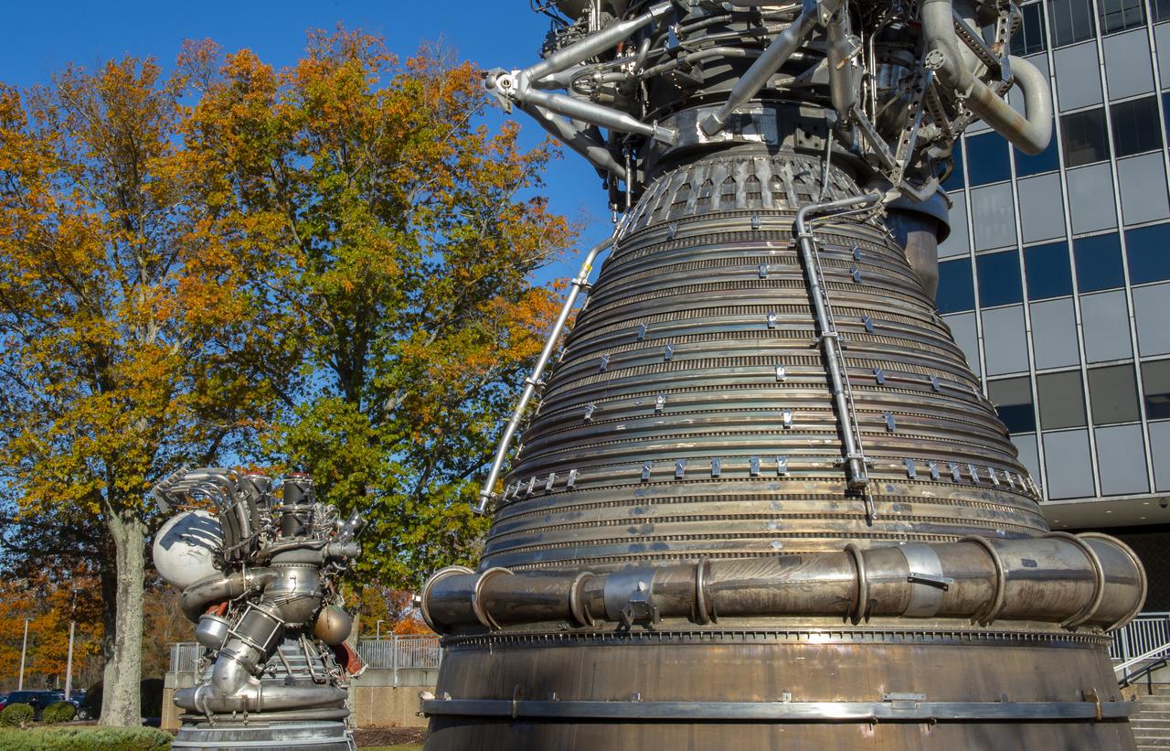
SEASONAL VIEWS, FALL, (NOVEMBER 13, 2019), OF MSFC BUILDING 4200
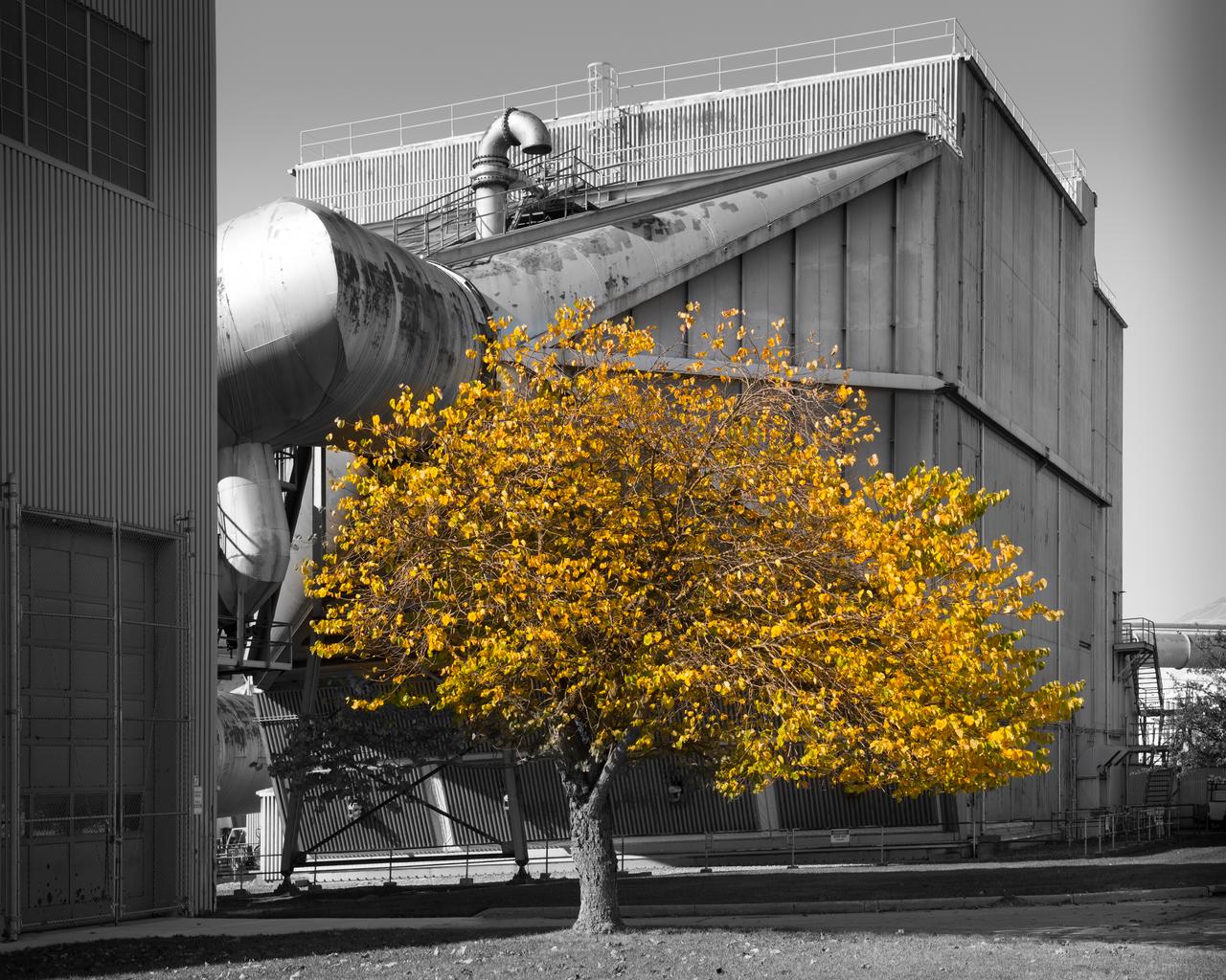
Fall Colored Tree on the Lawn of the 10x10 SWT Air Dryer Building

Juniper Doucette and her mother Chloe Doucette, head of education at the museum of Idaho Falls, enjoying the 2017 total solar eclipse.
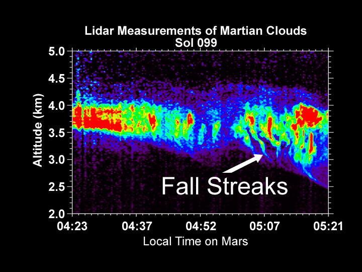
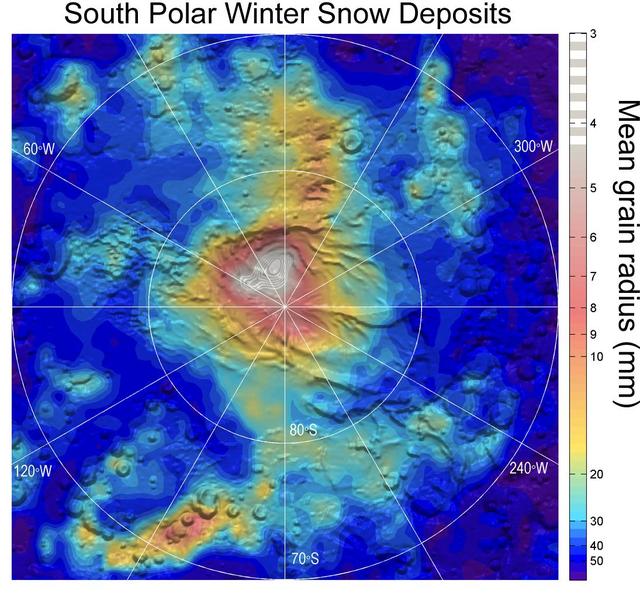
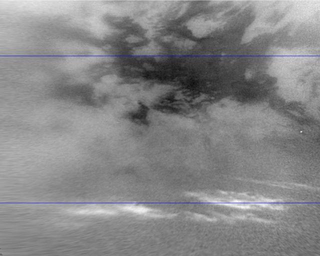
Lidar Measurements of Snow Falling from Martian Clouds
Earth-based images of the Fall 1999 Loki Eruption
The Fall 2011 eclipse season started on September 11, 2011. Here is an AIA 304 image from 0658 UT. SDO has eclipse seasons twice a year near each equinox. For three weeks near midnight Las Cruces time (about 0700 UT) our orbit has the Earth pass between SDO and the Sun. These eclipses can last up to 72 minutes in the middle of an eclipse season. The current eclipse season started on September 11 and lasts until October 4. To read more about SDO go to: <a href="http://sdo.gsfc.nasa.gov/" rel="nofollow">sdo.gsfc.nasa.gov/</a> Credit: NASA/GSFC/SDO <b><a href="http://www.nasa.gov/centers/goddard/home/index.html" rel="nofollow">NASA Goddard Space Flight Center</a></b> enables NASA’s mission through four scientific endeavors: Earth Science, Heliophysics, Solar System Exploration, and Astrophysics. Goddard plays a leading role in NASA’s accomplishments by contributing compelling scientific knowledge to advance the Agency’s mission. <b>Follow us on <a href="http://twitter.com/NASA_GoddardPix" rel="nofollow">Twitter</a></b> <b>Like us on <a href="http://www.facebook.com/pages/Greenbelt-MD/NASA-Goddard/395013845897?ref=tsd" rel="nofollow">Facebook</a></b> <b>Find us on <a href="http://instagrid.me/nasagoddard/?vm=grid" rel="nofollow">Instagram</a></b>

The Fall 2011 eclipse season started on September 11. Here is an AIA 171 image from 0657 UT with the first eclipse! SDO has eclipse seasons twice a year near each equinox. For three weeks near midnight Las Cruces time (about 0700 UT) our orbit has the Earth pass between SDO and the Sun. These eclipses can last up to 72 minutes in the middle of an eclipse season. The current eclipse season started on September 11 and lasts until October 4. To read more about SDO go to: <a href="http://sdo.gsfc.nasa.gov/" rel="nofollow">sdo.gsfc.nasa.gov/</a> Credit: NASA/GSFC/SDO <b><a href="http://www.nasa.gov/centers/goddard/home/index.html" rel="nofollow">NASA Goddard Space Flight Center</a></b> enables NASA’s mission through four scientific endeavors: Earth Science, Heliophysics, Solar System Exploration, and Astrophysics. Goddard plays a leading role in NASA’s accomplishments by contributing compelling scientific knowledge to advance the Agency’s mission. <b>Follow us on <a href="http://twitter.com/NASA_GoddardPix" rel="nofollow">Twitter</a></b> <b>Like us on <a href="http://www.facebook.com/pages/Greenbelt-MD/NASA-Goddard/395013845897?ref=tsd" rel="nofollow">Facebook</a></b> <b>Find us on <a href="http://instagrid.me/nasagoddard/?vm=grid" rel="nofollow">Instagram</a></b>
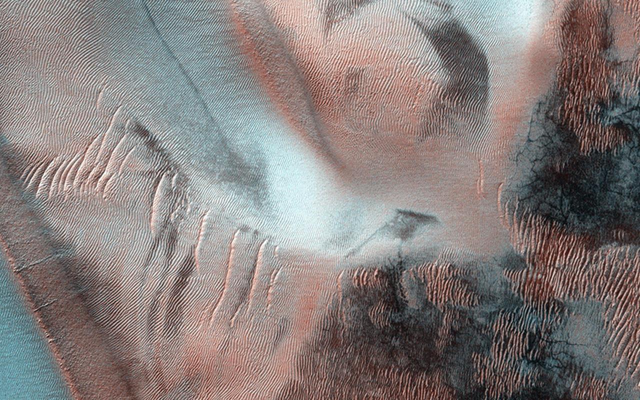
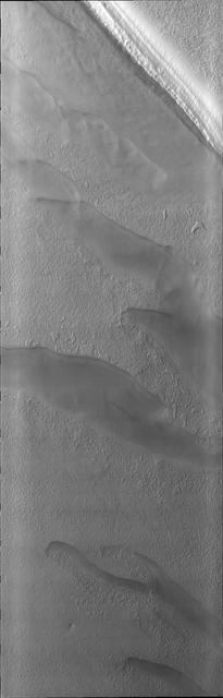
Richardson Crater is home to this sea of sand dunes. It was fall in the Southern hemisphere when NASA MRO acquired this image of the dunes frosted with the first bit of carbon dioxide ice condensed from the atmosphere.
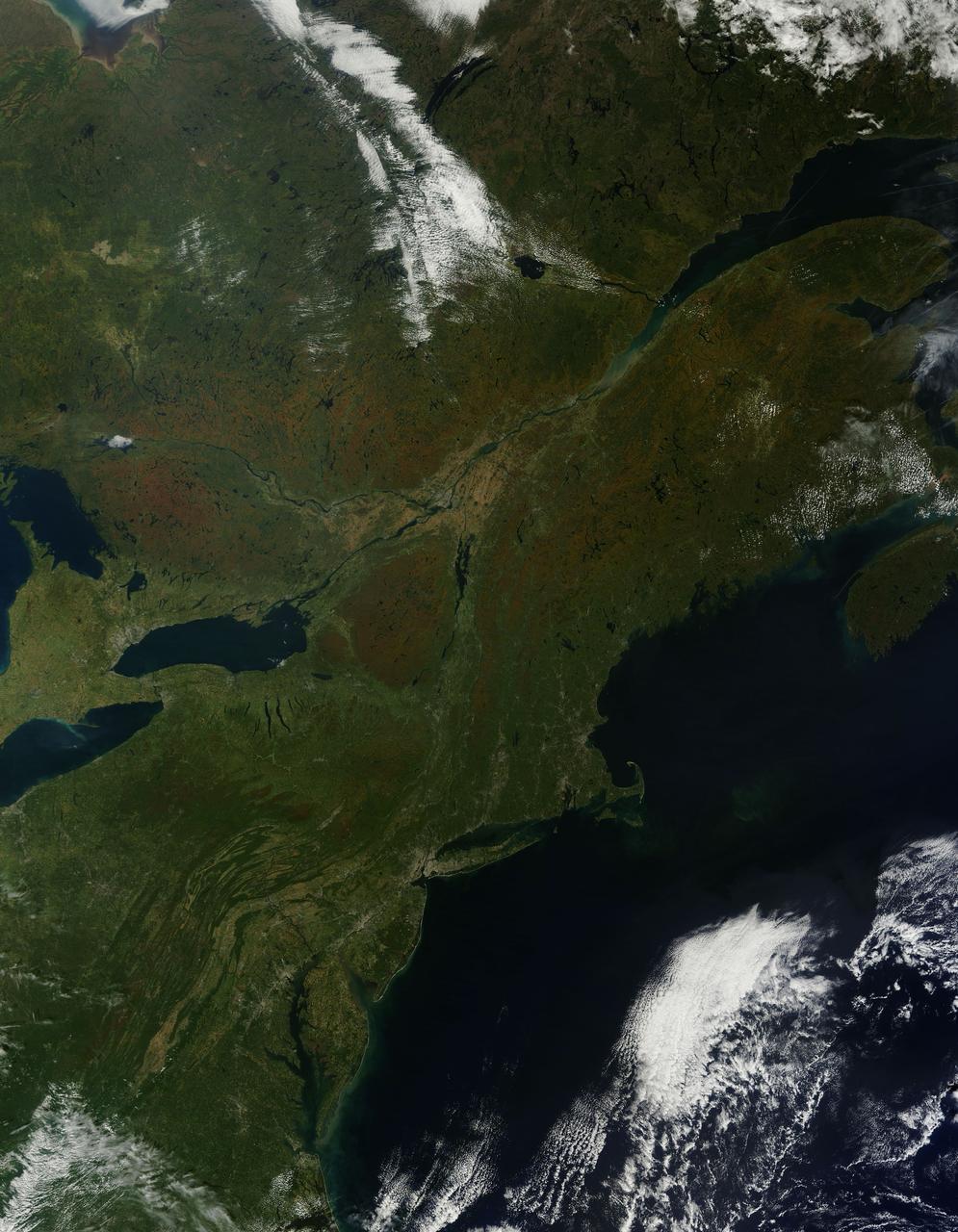
As temperatures dropped and daylight began to shorten, autumn colors began to wash over the deciduous forests of North America. The Moderate Resolution Imaging Spectroradiometer (MODIS) aboard NASA’s Terra satellite captured this true-color image of the northeastern United States and Canada on September 27, 2014. Washes of orange, brown and yellow are brightest in the Upper Peninsula of Michigan, upstate New York, New Hampshire, Vermont, Maine, and southern Quebec and Ontario. Also, faint traces of phytoplankton blooms can be seen in the offshore waters of the Atlantic Ocean. The transition of autumn leaves from green, to glowing with colors, to browning and dropping to the ground, involve several complex interactions and reactions. However, length of sunlight and the temperature changes are dominant factors. Topography also plays a role, as does latitude. Temperature tends to drop faster at higher elevations and at higher latitudes, and day length shortens more quickly at higher latitudes. Color change tends to begin in the north and sweep southward, and change begins at mountain tops then moves into valleys. As explained by the U.S. Forest Service, certain species of trees produce certain colors. Oaks generally turn red, brown, or russet; hickories become golden bronze; aspen and yellow-poplar turn golden. Maples differ by species. Red maple turns brilliant scarlet; sugar maple, orange-red; and black maple, yellow. Leaves of some trees, such as elms, simply become brown. Credit: NASA/GSFC/Jeff Schmaltz/MODIS Land Rapid Response Team <b><a href="http://www.nasa.gov/audience/formedia/features/MP_Photo_Guidelines.html" rel="nofollow">NASA image use policy.</a></b> <b><a href="http://www.nasa.gov/centers/goddard/home/index.html" rel="nofollow">NASA Goddard Space Flight Center</a></b> enables NASA’s mission through four scientific endeavors: Earth Science, Heliophysics, Solar System Exploration, and Astrophysics. Goddard plays a leading role in NASA’s accomplishments by contributing compelling scientific knowledge to advance the Agency’s mission. <b>Follow us on <a href="http://twitter.com/NASAGoddardPix" rel="nofollow">Twitter</a></b> <b>Like us on <a href="http://www.facebook.com/pages/Greenbelt-MD/NASA-Goddard/395013845897?ref=tsd" rel="nofollow">Facebook</a></b> <b>Find us on <a href="http://instagram.com/nasagoddard?vm=grid" rel="nofollow">Instagram</a></b>
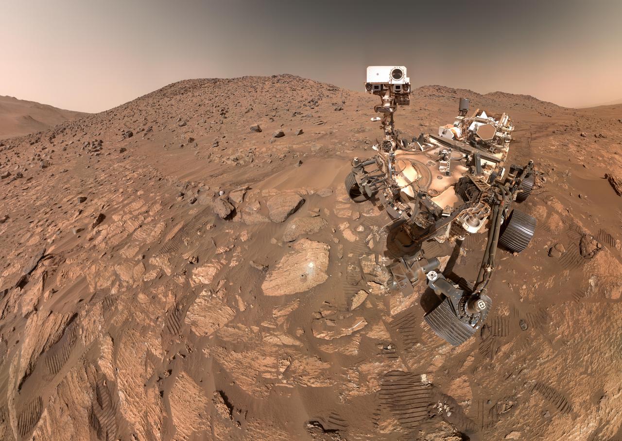
NASA's Perseverance Mars rover took this selfie on July 23, 2024, the 1,218th Martian day, or sol, of the mission. To the left of the rover near the center of the image is the arrowhead-shaped rock nicknamed "Cheyava Falls," which has features that may bear on the question of whether Mars was home to microscopic life in the distant past. The small dark hole in the rock is where Perseverance took a core sample, which is now in a sample tube stored in the rover's belly. The white patch to the right of the hole is where the rover used an abrasion tool to clear away the top surface, allowing science instruments to study the rock's composition. Measuring 3.2 feet by 2 feet (1 meter by 0.6 meters) and named after a Grand Canyon waterfall, Cheyava Falls lies at the northern edge of Neretva Vallis, an ancient river valley measuring a quarter-mile (400 meters) wide that was carved by water rushing into Jezero Crater long ago. The selfie is composed of 62 images taken by the WATSON (Wide Angle Topographic Sensor for Operations and eNgineering) camera on the end of the rover's robotic arm. The images were stitched together after being sent back to Earth. Animation available at https://photojournal.jpl.nasa.gov/catalog/PIA26344
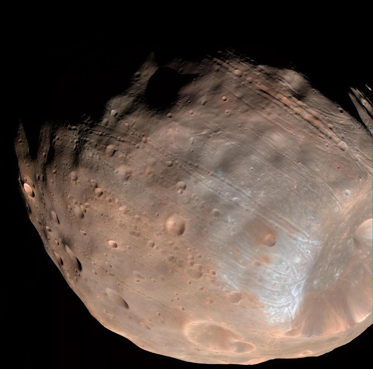
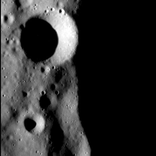
New modeling indicates that the grooves on Mars’ moon Phobos could be produced by tidal forces – the mutual gravitational pull of the planet and the moon. Initially, scientists had thought the grooves were created by the massive impact that made Stickney crater (lower right). Credits: NASA/JPL-Caltech/University of Arizona Read more: <a href="http://go.nasa.gov/1RLCS1v" rel="nofollow">go.nasa.gov/1RLCS1v</a> <b><a href="http://www.nasa.gov/audience/formedia/features/MP_Photo_Guidelines.html" rel="nofollow">NASA image use policy.</a></b> <b><a href="http://www.nasa.gov/centers/goddard/home/index.html" rel="nofollow">NASA Goddard Space Flight Center</a></b> enables NASA’s mission through four scientific endeavors: Earth Science, Heliophysics, Solar System Exploration, and Astrophysics. Goddard plays a leading role in NASA’s accomplishments by contributing compelling scientific knowledge to advance the Agency’s mission. <b>Follow us on <a href="http://twitter.com/NASAGoddardPix" rel="nofollow">Twitter</a></b> <b>Like us on <a href="http://www.facebook.com/pages/Greenbelt-MD/NASA-Goddard/395013845897?ref=tsd" rel="nofollow">Facebook</a></b> <b>Find us on <a href="http://instagrid.me/nasagoddard/?vm=grid" rel="nofollow">Instagram</a></b>
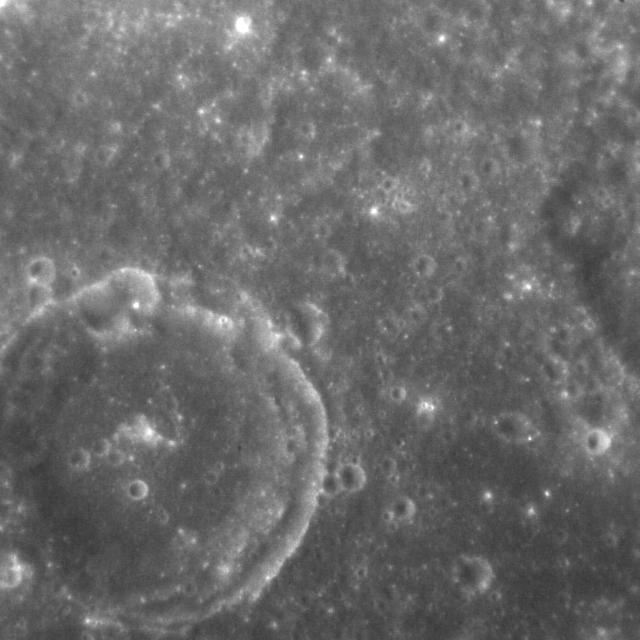
![Various researchers are often pre-occupied with the quest for flowing water on Mars. However, this image from NASA's Mars Reconnaissance Orbiter (MRO), shows one of the many examples from Mars where lava (when it was molten) behaved in a similar fashion to liquid water. The northern rim of a 30-kilometer diameter crater situated in the western part of the Tharsis volcanic province is shown. The image shows that a lava flow coming from the north-northeast surrounded the crater rim, and rose to such levels that it breached the crater rim at four locations to produce spectacular multi-level lava falls (one in the northwest and three in the north). These lava "falls" cascaded down the wall and terraces of the crater to produce a quasi-circular flow deposit. It seems that the flows were insufficient to fill or even cover the pre-existing deposits of the crater floor. This is evidenced by the darker-toned lavas that overlie the older, and possibly dustier, lighter-toned deposits on the crater floor. This image covers the three falls in the north-central region of the crater wall. The lava flows and falls are distinct as they are rougher than the original features that are smooth and knobby. In a close-up image the rough-textured lava flow to the north has breached the crater wall at a narrow point, where it then cascades downwards, fanning out and draping the steeper slopes of the wall in the process. Image scale is 54.5 centimeters (21.5 inches) per pixel (with 2 x 2 binning); objects on the order of 164 centimeters (64.6 inches) across are resolved.] North is up. https://photojournal.jpl.nasa.gov/catalog/PIA21763](https://images-assets.nasa.gov/image/PIA21763/PIA21763~medium.jpg)
Various researchers are often pre-occupied with the quest for flowing water on Mars. However, this image from NASA's Mars Reconnaissance Orbiter (MRO), shows one of the many examples from Mars where lava (when it was molten) behaved in a similar fashion to liquid water. The northern rim of a 30-kilometer diameter crater situated in the western part of the Tharsis volcanic province is shown. The image shows that a lava flow coming from the north-northeast surrounded the crater rim, and rose to such levels that it breached the crater rim at four locations to produce spectacular multi-level lava falls (one in the northwest and three in the north). These lava "falls" cascaded down the wall and terraces of the crater to produce a quasi-circular flow deposit. It seems that the flows were insufficient to fill or even cover the pre-existing deposits of the crater floor. This is evidenced by the darker-toned lavas that overlie the older, and possibly dustier, lighter-toned deposits on the crater floor. This image covers the three falls in the north-central region of the crater wall. The lava flows and falls are distinct as they are rougher than the original features that are smooth and knobby. In a close-up image the rough-textured lava flow to the north has breached the crater wall at a narrow point, where it then cascades downwards, fanning out and draping the steeper slopes of the wall in the process. Image scale is 54.5 centimeters (21.5 inches) per pixel (with 2 x 2 binning); objects on the order of 164 centimeters (64.6 inches) across are resolved.] North is up. https://photojournal.jpl.nasa.gov/catalog/PIA21763
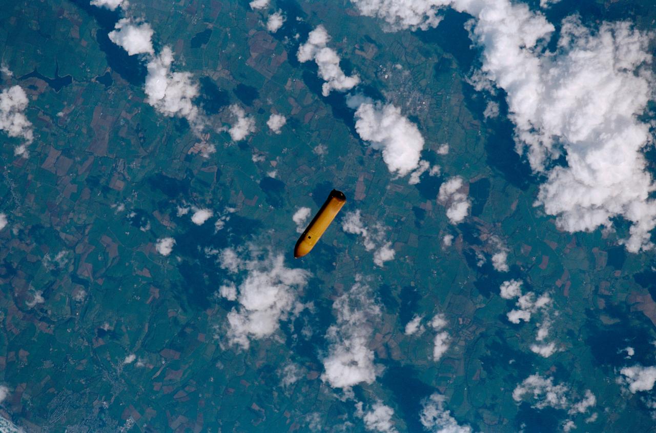
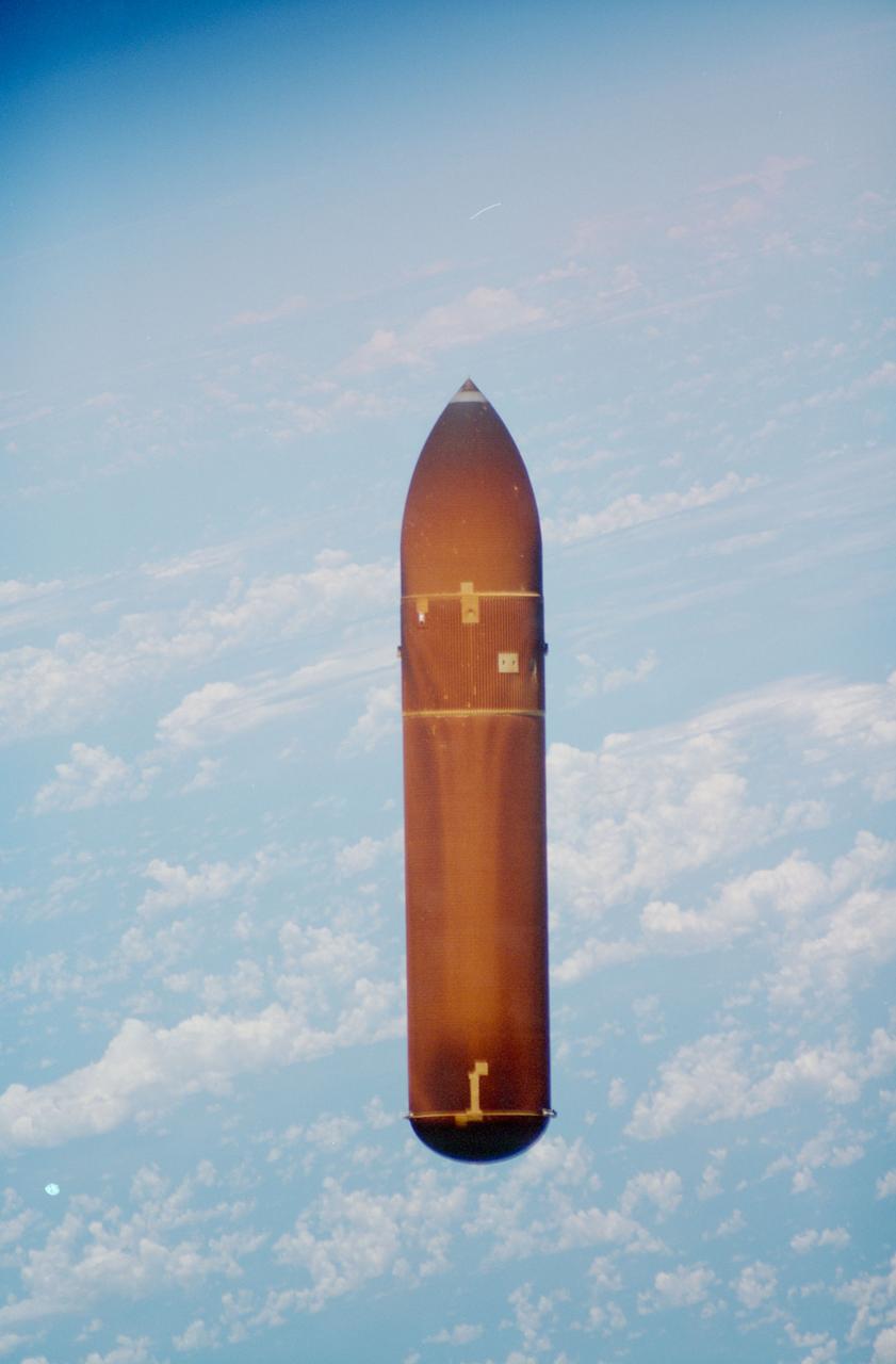
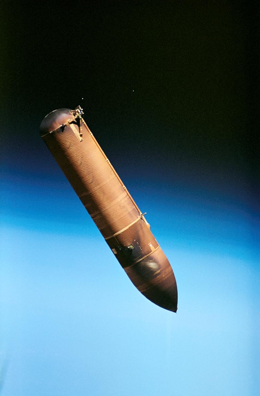
STS102-311-013 (8 March 2001) --- The external tank falls toward Earth's atmosphere during the completion of the launch phase of the STS-102 mission. Western Europe is in the background.
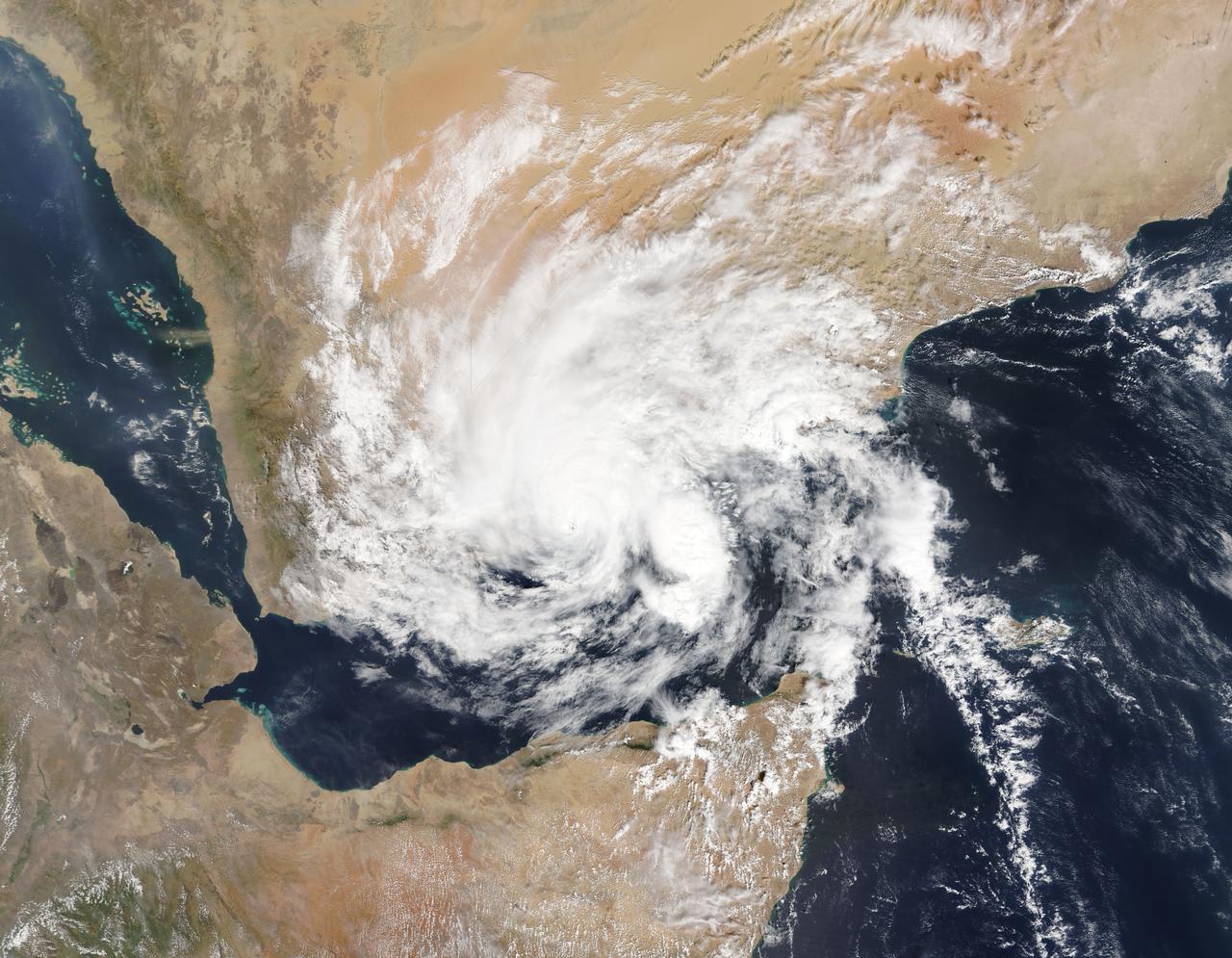
On Nov. 3, 2015 at 07:20 UTC (2:20 a.m. EDT) the MODIS instrument aboard NASA's Aqua satellite captured this image of Tropical Cyclone Chapala over Yemen. Credit: NASA Goddard MODIS Rapid Response Team <b><a href="http://www.nasa.gov/audience/formedia/features/MP_Photo_Guidelines.html" rel="nofollow">NASA image use policy.</a></b> <b><a href="http://www.nasa.gov/centers/goddard/home/index.html" rel="nofollow">NASA Goddard Space Flight Center</a></b> enables NASA’s mission through four scientific endeavors: Earth Science, Heliophysics, Solar System Exploration, and Astrophysics. Goddard plays a leading role in NASA’s accomplishments by contributing compelling scientific knowledge to advance the Agency’s mission. <b>Follow us on <a href="http://twitter.com/NASAGoddardPix" rel="nofollow">Twitter</a></b> <b>Like us on <a href="http://www.facebook.com/pages/Greenbelt-MD/NASA-Goddard/395013845897?ref=tsd" rel="nofollow">Facebook</a></b> <b>Find us on <a href="http://instagrid.me/nasagoddard/?vm=grid" rel="nofollow">Instagram</a></b>
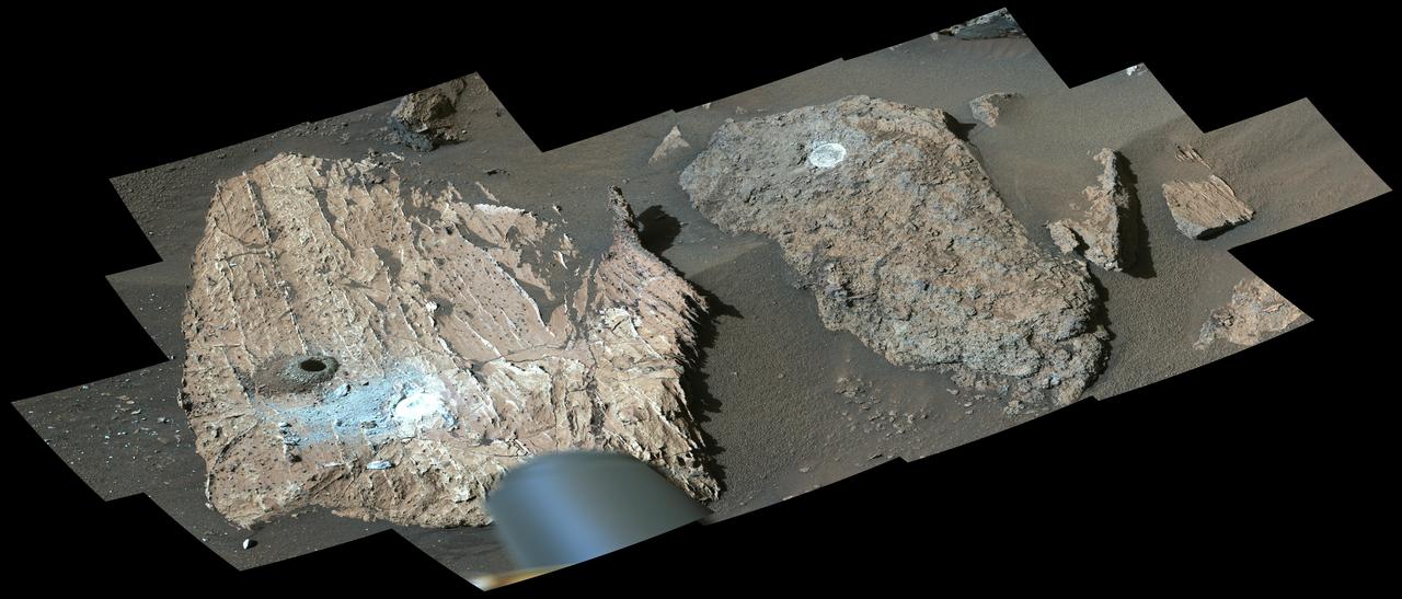
NASA's Perseverance Mars rover used its Mastcam-Z instrument to view this workspace around the sample collected from a rock nicknamed "Cheyava Falls." A drill hole is visible (far left) where a sample was collected on July 21, 2024. At right is a rock nicknamed "Steamboat Mountain." A circular white abrasion patch can be seen on each rock; these are where the rover used an abrasion tool to clear away the top surface, allowing instruments to study the rocks' composition. The images that make up this composite were taken by the rover's Mastcam-Z instrument on July 23, 2024, the 1217th day, or sol, of the mission. https://photojournal.jpl.nasa.gov/catalog/PIA26401

STS060-06-037 (3-11 Feb 1994) --- The city lights of Buffalo and Toronto outline the shores of the east end of Lake Erie and the west end of Lake Ontario in this night scene of western New York and southern Ontario. Between the two major cities are the cities of Niagara Falls, New York and Niagara Falls, Canada, which straddle the Niagara River just north of the actual falls. This photograph was taken with a special ASA-1600 film that is normally used for night-time photography of aurora, noctilucent clouds, biomass burning, and city lights.
STS070-303-007 (13 JULY 1995) --- The external fuel tank (ET) for STS-70 is photographed just after falling away from the space shuttle Discovery en route to the 101st human-tended United States space flight.

Farley Davis and Edward Ahmad explain map of MSFC to Fall Job Shadowing Student Deshon Washington, a student at Alabama A&M University.
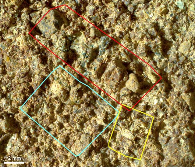
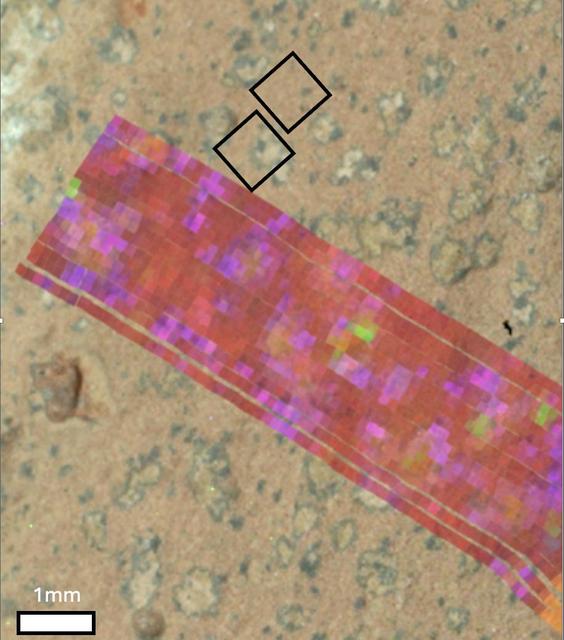
Before collecting a rock sample at a spot nicknamed "Otis Peak," NASA's Perseverance Mars rover employed an abrasion tool to wear down the rock surface and then used the Planetary Instrument for X-ray Lithochemistry, or PIXL, to study the rock's internal chemistry. This image of the abrasion patch, dubbed "Ouzel Falls," was taken in May 2023 by WATSON (Wide Angle Topographic Sensor for Operations and eNgineering), a camera that is part of an instrument called Scanning Habitable Environments with Raman & Luminescence for Organics & Chemicals, or SHERLOC, on the end of the rover's robotic arm. Data from PIXL is laid over the image. Colored squares show different areas where PIXL's X-ray beam scanned the rock's surface. The instrument's data found the rock was rich in phosphate, a material found in the DNA and cell membranes of all known life, and which also serves as a way to store and transfer energy within living things. The Ouzel Falls scan areas contain a rich diversity of other mineral grains, including igneous minerals transported as sand and pebbles, such as olivine and spinel, and minerals crystallized from water, such as carbonates, clays, and sulfates. Each of these record unique aspects of the magmatic, climatic, and paleoenvironmental history of the ancient lake within Jezero Crater and the surrounding region. This diversity will make the Otis Peak sample a treasure trove for scientists on Earth who may study it in the future. A key objective for Perseverance's mission on Mars is astrobiology, including the search for signs of ancient microbial life. The rover will characterize the planet's geology and past climate, pave the way for human exploration of the Red Planet, and be the first mission to collect and cache Martian rock and regolith (broken rock and dust). Subsequent NASA missions, in cooperation with ESA (European Space Agency), would send spacecraft to Mars to collect these sealed samples from the surface and return them to Earth for in-depth analysis. The Mars 2020 Perseverance mission is part of NASA's Moon to Mars exploration approach, which includes Artemis missions to the Moon that will help prepare for human exploration of the Red Planet. https://photojournal.jpl.nasa.gov/catalog/PIA26206
Learjet 25 Acoustic Measurement Testing at Niagara Falls, New York Airport
NASA's Perseverance Mars rover generated this mineral map showing the presence of two minerals – vivianite (purple and pink) and greigite (dull yellow and green) – on the surface of a rock nicknamed "Cheyava Falls." The data helped scientists determine the rock contained a potential biosignature, which is a substance or structure that might have a biological origin but requires more data or further study before a conclusion can be reached about the absence or presence of life. Perseverance's PIXL (Planetary Instrument for X-ray Lithochemistry) and SHERLOC (Scanning Habitable Environments with Raman & Luminescence for Organics & Chemicals)instruments found a distinct pattern of minerals arranged into reaction fronts (points of contact where chemical and physical reactions occur) that the team called "leopard spots." The leopard spots carried the signature of vivianite (hydrated iron phosphate) and greigite (iron sulfide). Vivianite appears within black spots mission scientists refer to as "poppy seeds" and in the dark rims of the larger "leopard spots." Greigite is seen within the interiors of the leopard spots, which could have been left behind by microbial life if it had used the raw ingredients – the organic carbon, sulfur, and phosphorus – in the rock as an energy source. Vivianite is frequently found on Earth in sediments and peat bogs and around decaying organic matter. Similarly, certain forms of microbial life on Earth can produce greigite. The combination of these minerals, which appear to have formed by electron-transfer reactions between the sediment and organic matter, is a potential "fingerprint" for microbial life, which would use these reactions to produce energy for growth. The minerals can also be generated abiotically, or without the presence of life. https://photojournal.jpl.nasa.gov/catalog/PIA26640
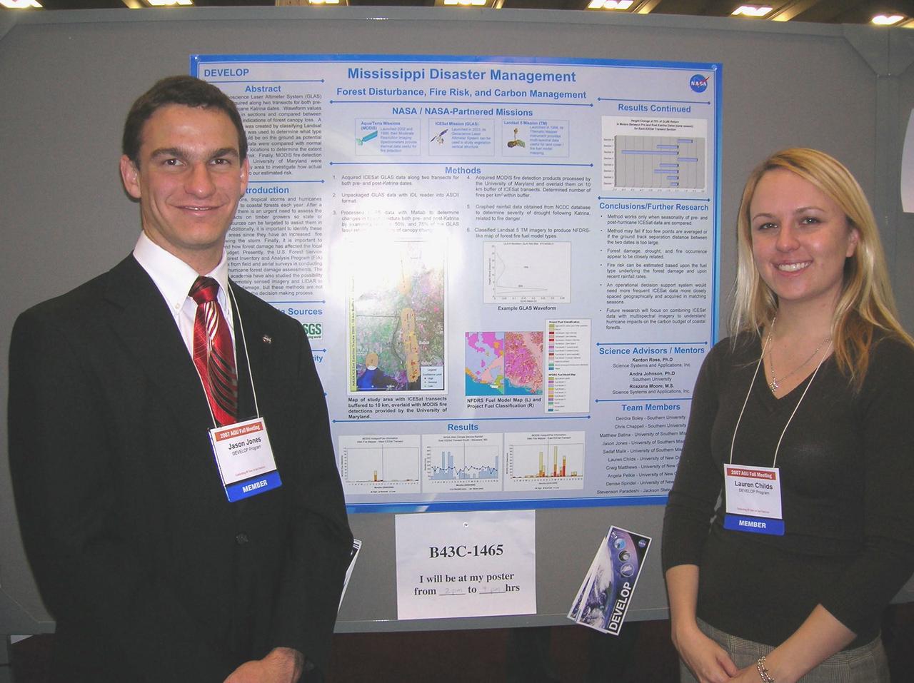
Jason Jones, left, and Lauren Childs are pictured with their presentation during the poster session at the American Geophysical Union Fall Meeting in San Francisco, Calif., Dec. 10-14, 2007.
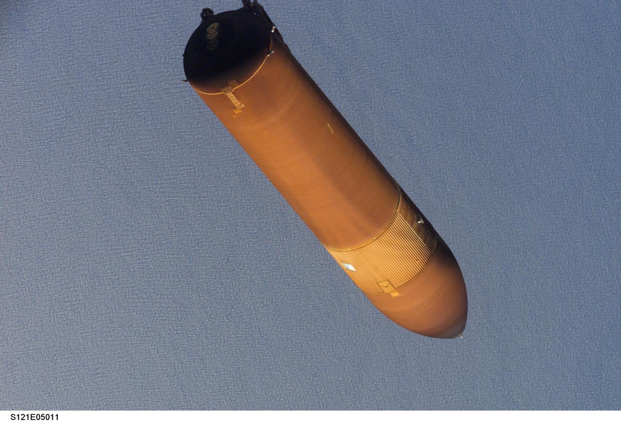
STS121-E-05011 (4 July 2006)-- This picture of the STS-121 external tank was taken with a digital still camera by an astronaut only seconds after separation from the Space Shuttle Discovery on launch day. Engineers, managers and flight controllers have carefully studied this image and other frames from this series as well as a number of pictures showing the falling ET as photographed from umbilical well cameras.
S121-E-05006 (4 July 2006) --- This picture of the STS-121 external tank was taken with a digital still camera by an astronaut only seconds after separation from the Space Shuttle Discovery on launch day. Engineers, managers and flight controllers have carefully studied this image and other frames from this series as well as a number of pictures showing the falling ET as photographed from umbilical well cameras.
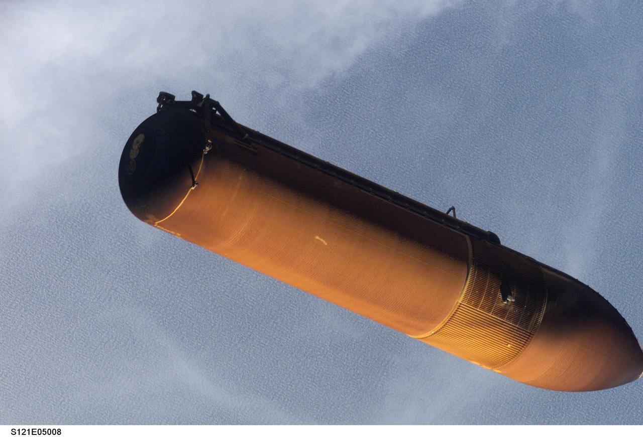
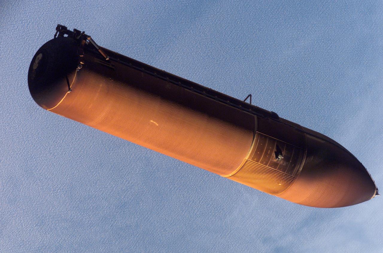
STS121-E-05008 (4 July 2006)-- This picture of the STS-121 external tank was taken with a digital still camera by an astronaut only seconds after separation from the Space Shuttle Discovery on launch day. Engineers, managers and flight controllers have carefully studied this image and other frames from this series as well as a number of pictures showing the falling ET as photographed from umbilical well cameras.
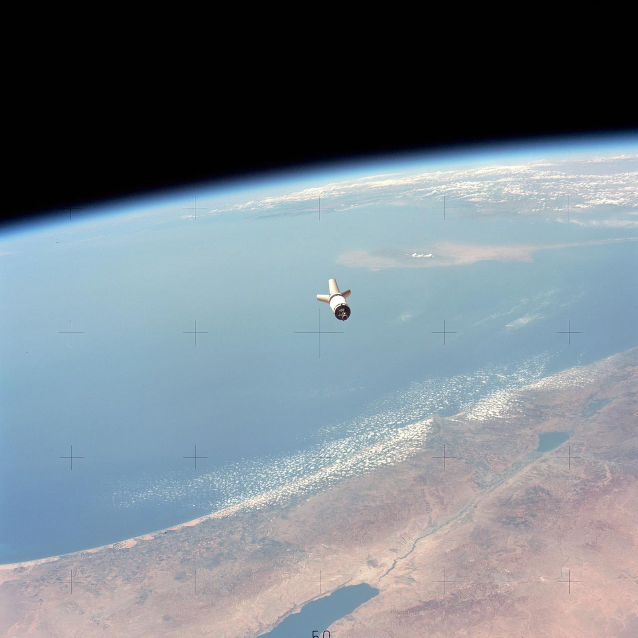
SL3-114-1634 (July-September 1973) --- Skylab 3, Saturn S-4B (S-IVB) stage falls away from the Command Module (CM) after separation. Earth limb in background, pass over Israel, the Dead Sea and the Mediterranean Sea. Photo credit: NASA
STS057-03-017 (21 June 1993) --- The external fuel tank falls toward Earth after being jettisoned from the Space Shuttle Endeavour as the spacecraft headed toward its ten-day stay in Earth orbit. A 35mm camera was used to record the ET jettison.
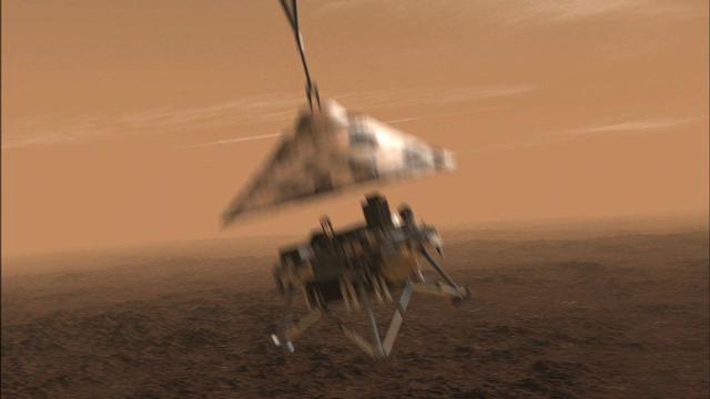
NASA Phoenix Mars Lander will be in free fall after it separates from its back shell and parachute, but not for long.
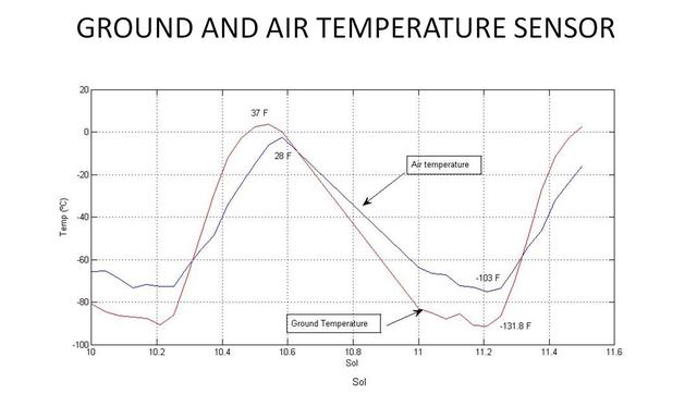
This graph shows the rise and fall of air and ground temperatures on Mars obtained by NASA Curiosity rover.
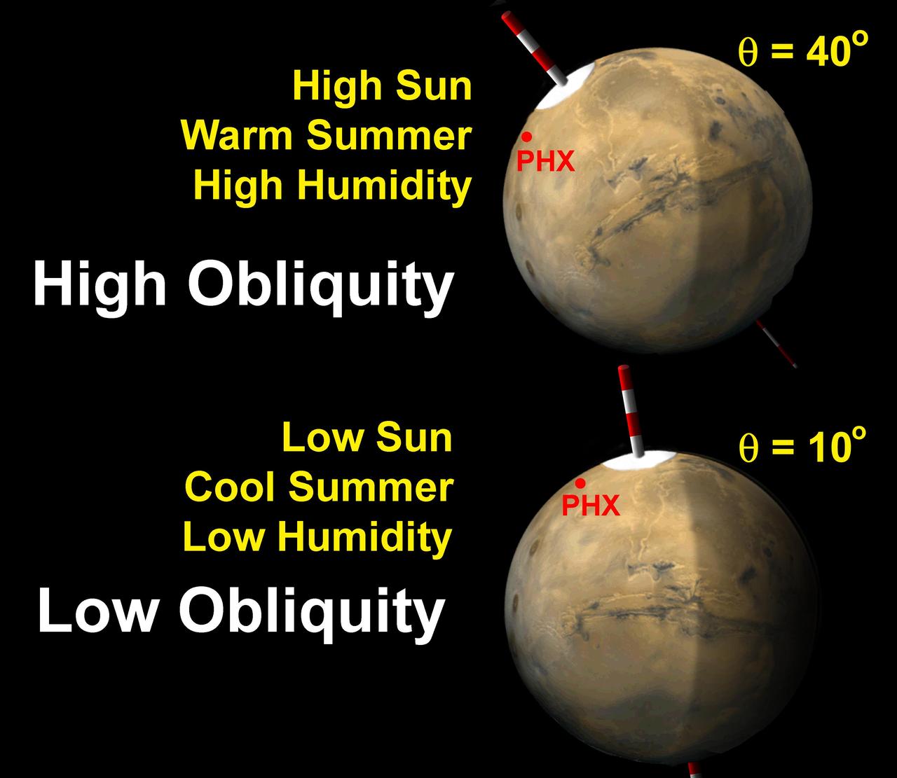
The tilt of Mars spin axis obliquity varies cyclically over hundreds of thousands of years, and affects the sunlight falling on the poles.
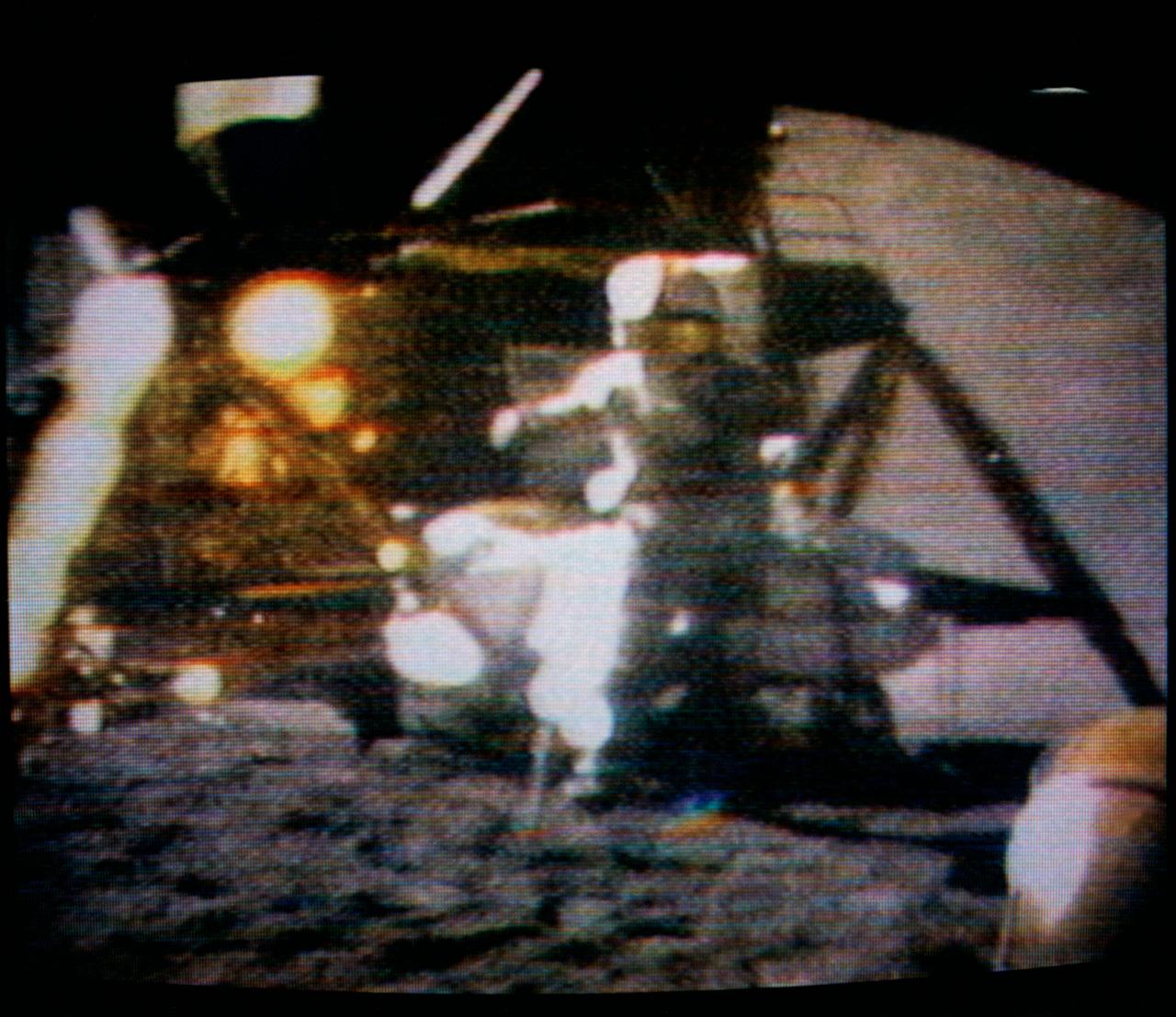
S71-43788 (2 Aug. 1971) --- Astronaut David R. Scott, Apollo 15 commander, watches a geological hammer and a feather hit the lunar surface simultaneously in a test of Galileo's law of motion concerning falling bodies, as seen in this color reproduction taken from a transmission made by the RCA color television camera mounted on the Lunar Roving Vehicle (LRV). Scott released the hammer from his right hand and the feather from his left at the same instant. Galileo (1564-1642) was the great Italian astronomer and physicist. This experiment occurred toward the end of the third and final lunar surface extravehicular activity (EVA) by astronauts Scott and James B. Irwin, lunar module pilot. While Scott and Irwin descended in the Lunar Module (LM) to explore the moon, astronaut Alfred M. Worden, command module pilot, remained in the Command and Service Modules (CSM) in lunar orbit.
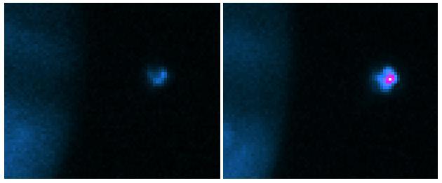
This image from NASA Spitzer Space Telescope shows two young brown dwarfs, objects that fall somewhere between planets and stars in terms of their temperature and mass.
Observations by NASA Mars Reconnaissance Orbiter have detected carbon-dioxide snow clouds on Mars and evidence of carbon-dioxide snow falling to the surface.
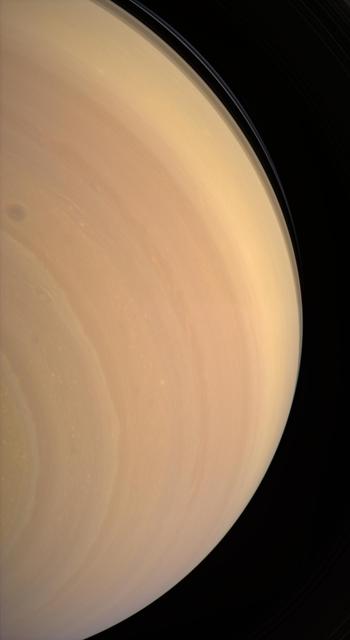
The Cassini spacecraft gazes upward at the face of giant Saturn, seeing beyond the equator to where ring shadows fall across the bluish northern latitudes
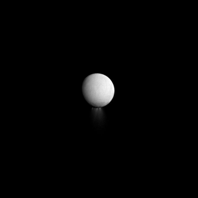
As the long winter night deepens at Enceladus south pole, its jets are also progressively falling into darkness in this image observed by NASA Cassini spacecraft.
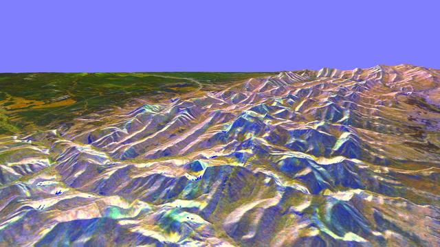
This is a three-dimensional perspective of the eastern front range of the Rocky Mountains, about 120 kilometers 75 miles west of Great Falls, Montana.
This VIS image of the south pole was taken at the end of summer. Frost will soon start to form as the season transitions into fall. Fall in the southern hemisphere means spring in the northern, so the north polar cap is just starting to thaw. Orbit Number: 67893 Latitude: -87.0251 Longitude: 275.679 Instrument: VIS Captured: 2017-04-04 06:19 https://photojournal.jpl.nasa.gov/catalog/PIA21679

St. Paul Minnesota high school student, Roger Johnston (center), Gene Vacca (left) of NASA Headquarters, and Ann Whitaker of the Marshall Space Flight Center (MSFC) discuss the equipment to be used for the student’s experiment, “Capillary Action Studies in a State of Free Fall”, to be performed aboard the Skylab the following year. Johnston was among 25 winners of a contest in which some 3,500 high school students proposed experiments for the following year’s Skylab mission. The nationwide scientific competition was sponsored by the National Science Teachers Association and the National Aeronautics and Space Administration (NASA). The winning students, along with their parents and sponsor teachers, visited MSFC two months earlier where they met with scientists and engineers, participated in design reviews for their experiments, and toured MSFC facilities. Of the 25 students, 6 did not see their experiments conducted on Skylab because the experiments were not compatible with Skylab hardware and timelines. Of the 19 remaining, 11 experiments required the manufacture of additional equipment. The equipment for the experiments was manufactured at MSFC.

Dr. Michael Wargo, program scientist for materials science at NASA headquarters, explains the math and physics principles associated with freefall research to attendees at the arnual conference of the National Council of Teachers of Mathematics.
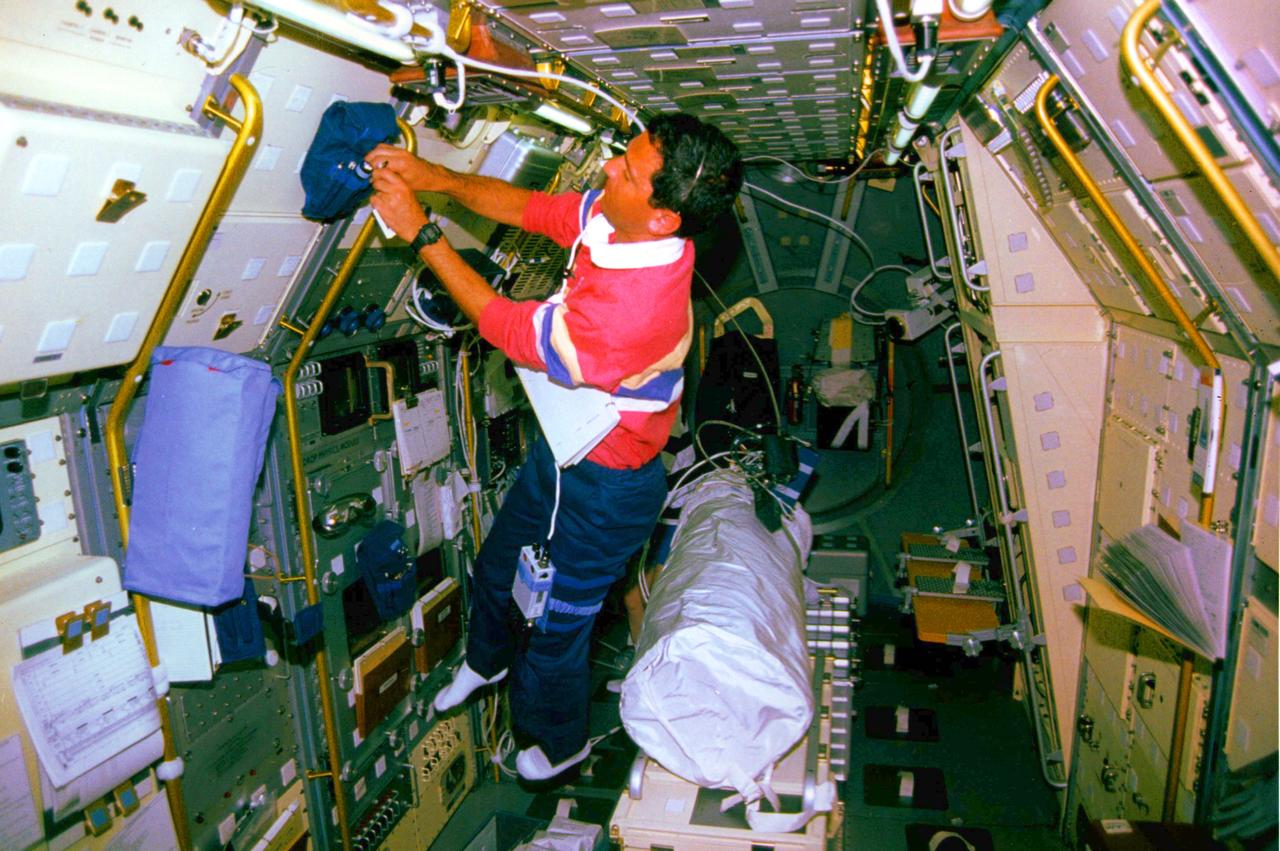
Larry DeLucas with the (LBNP) Lower Body Negative Pressure Experiment onboard STS-50.
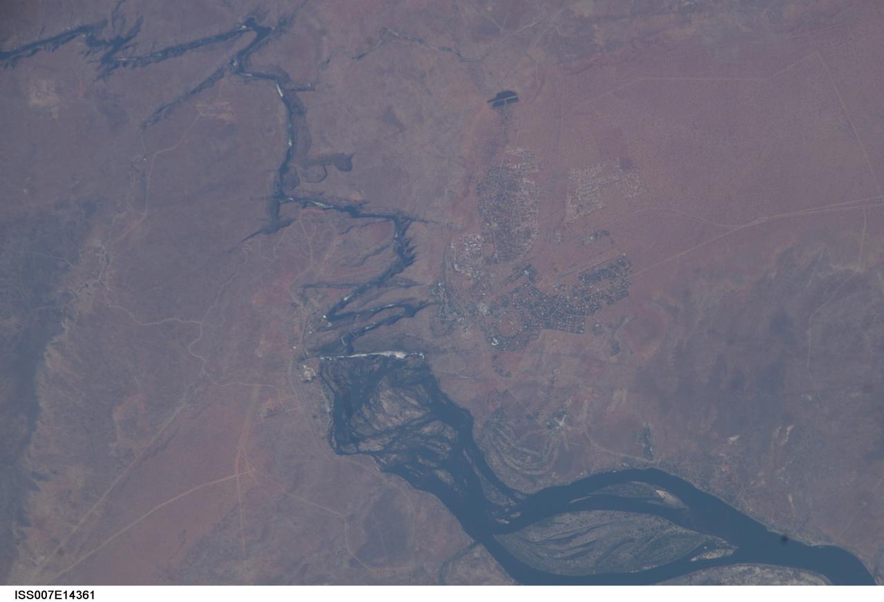
ISS007-E-14361 (4 September 2003) --- This view featuring Victoria Falls and the Zambezi River was photographed by one of the Expedition 7 crewmembers onboard the International Space Station (ISS). Victoria Falls is one of the most famous tourist sites in sub-Saharan Africa. The falls and their famous spray clouds are 1700 meters long, the longest sheet of falling water in the world. The falls appear as a ragged white line in this image. The small town of Victoria Falls in Zimbabwe appears just west of the falls, with smaller tourist facilities on the east bank in Zambia. A major river in south-central Africa, the Zambezi River flows from western Zambia to the Indian Ocean in Mozambique. It flows southeast in a wide bed before plunging suddenly 130 meters over the Victoria Falls into a narrow gorge.
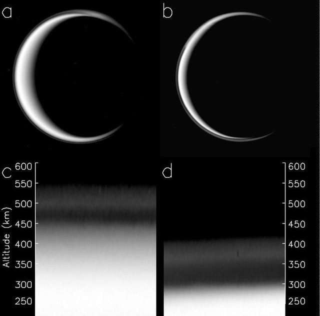
The change in Titan haze layer is illustrated in this figure, derived from data obtained by NASA Cassini spacecraft. The picture of Titan in panel a was taken on May 3, 2006, panel b was taken on April 2, 2010.

This image of Jupiter's southern hemisphere was captured by NASA's Juno spacecraft as it performed a close flyby of the gas giant planet on Dec. 16, 2017. Juno captured this color-enhanced image at 10:24 a.m. PST (1:24 p.m. EST) when the spacecraft was about 19,244 miles (30,970 kilometers) from the tops of Jupiter's clouds at a latitude of 49.9 degrees south -- roughly halfway between the planet's equator and its south pole. Citizen scientist Gerald Eichstädt processed this image using data from the JunoCam imager. https://photojournal.jpl.nasa.gov/catalog/PIA21977. - Enhanced image by Gerald Eichstädt based on images provided courtesy of NASA/JPL-Caltech/SwRI/MSSS
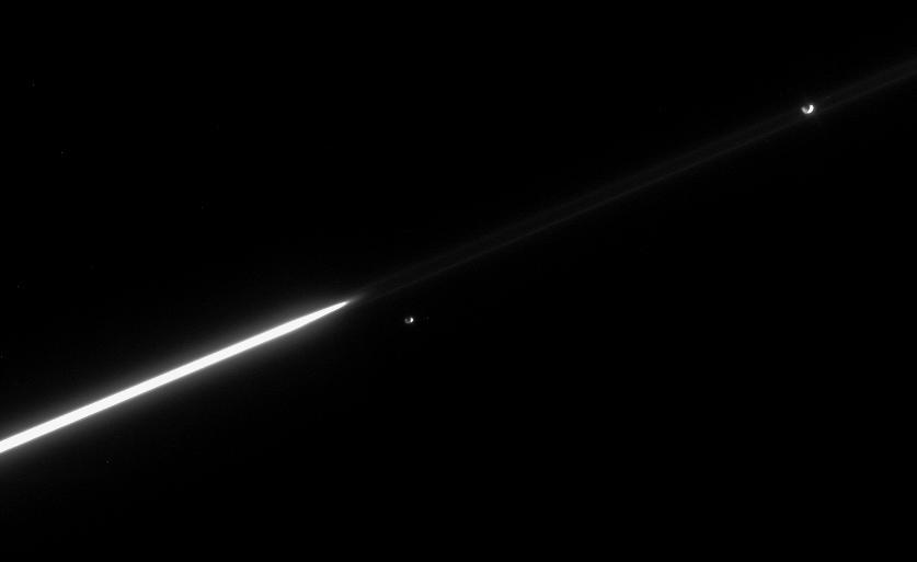
Janus and Epimetheus continue to separate, following their orbital swap in January 2006. Until 2010, Janus will remain the innermost of the pair, whose orbits around Saturn are separated by only about 50 kilometers 31 miles on average
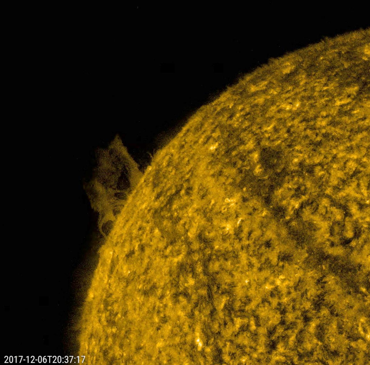
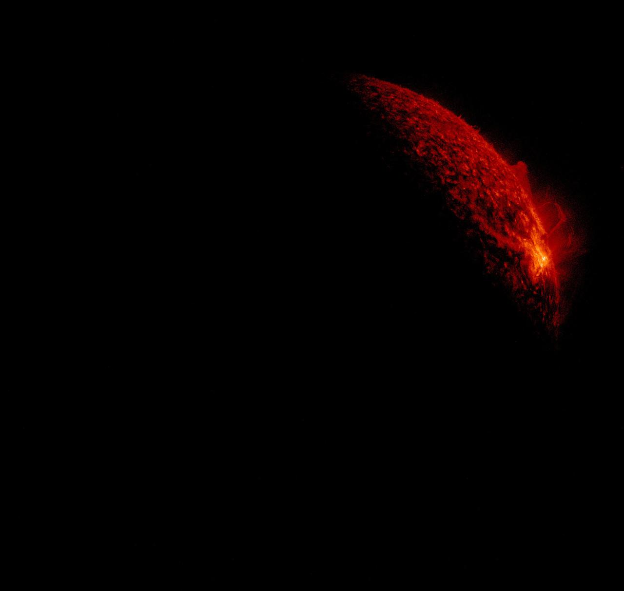
A small prominence slowly rose further up above the sun, then fell apart and back into the sun over about seven hours (Dec. 6, 2017). Prominences, notoriously unstable, are cooler clouds of particles tethered not far above the sun by magnetic forces. When it stretched out, its distance above the sun was several times the size of Earth. Images were taken in a wavelength of extreme ultraviolet light. These images are colorized since we cannot "see" ultraviolet light. In this case, a yellow tone was used instead of the normal red tint we use for this 304 Angstrom wavelength. Movies are available at https://photojournal.jpl.nasa.gov/catalog/PIA22195
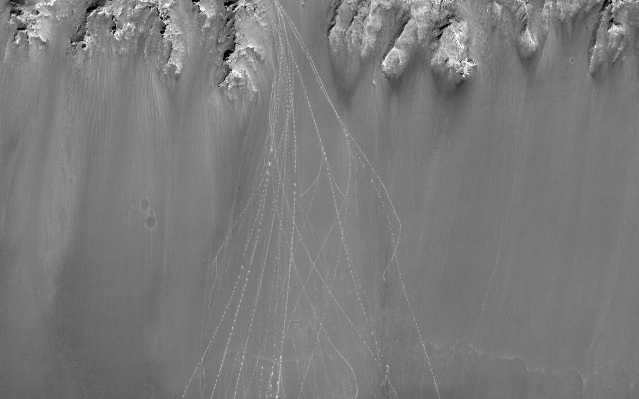
When boulders roll down a dusty Martian slope, they can leave long, dotted tracks behind on the slope surface as seen in this observation from NASA Mars Reconnaissance Orbiter.
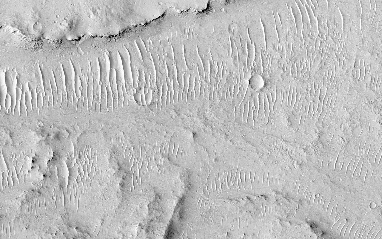
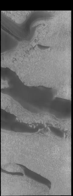
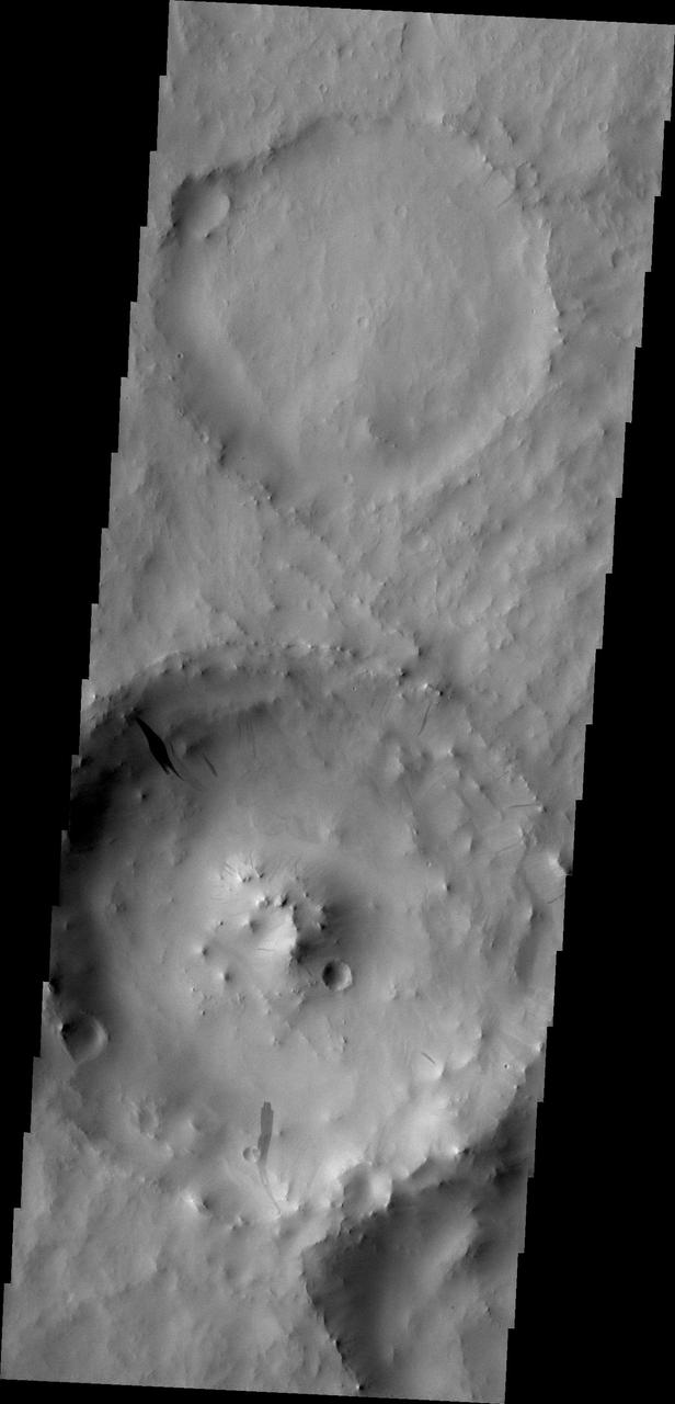
Kasei Valles is a valley system was likely carved by some combination of flowing water and lava. In some areas, erosion formed cliffs along the flow path resulting in water or lava falls. In some areas, erosion formed cliffs along the flow path resulting in water or lava falls. The flowing liquid is gone but the channels and "dry falls" remain. Since its formation, Kasei Valles has suffered impacts-resulting in craters-and has been mantled in dust, sand, and fine gravel as evidenced by the rippled textures. http://photojournal.jpl.nasa.gov/catalog/PIA20004
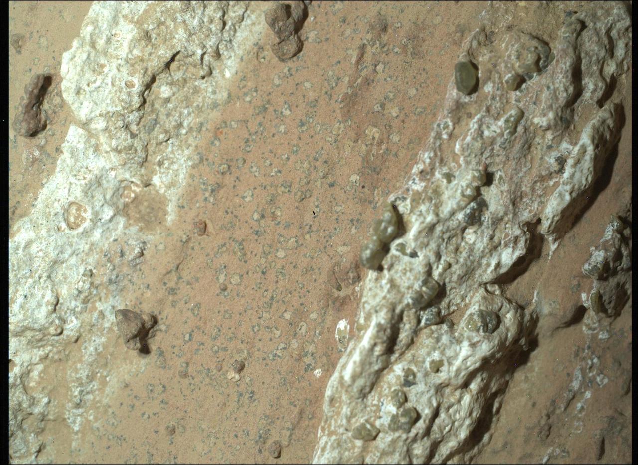
NASA's Perseverance Mars rover captured this image of a rock nicknamed "Cheyava Falls" on July 18, 2024, the 1,212th Martian day, or sol, of the mission. Running the length of the rock are large white calcium sulfate veins. Between those veins are bands of material whose reddish color suggests the presence of hematite, one of the minerals that gives Mars its distinctive rusty hue. Scientists are particularly interested in the millimeter-size, irregularly shaped light patches on the central reddish band (from lower left to upper right of the image) that are surrounded by a thin ring of dark material, akin to leopard spots. Spotting of this type on sedimentary terrestrial rocks can occur when chemical reactions involving hematite turn the rock from red to white. Those reactions can also release iron and phosphate, possibly causing the black halos to form, and they can be an energy source for microbes, hence the association between such features and microbes in a terrestrial setting. Measuring 3.2 feet by 2 feet (1 meter by 0.6 meters) and named after a Grand Canyon waterfall, Cheyava Falls was found in an ancient riverbed within the "Bright Angel" region of Mars' Jezero Crater. This image of the rock was captured using a camera called WATSON (Wide Angle Topographic Sensor for Operations and eNgineering), which is part of the SHERLOC (Scanning Habitable Environments with Raman and Luminescence for Organics and Chemicals) instrument suite located on the end of Perseverance's 7-foot-long (2-meter-long) robotic arm. SHERLOC looks for organic compounds – carbon-based molecules that are considered the building blocks of life – and detected them in Cheyava Falls. The white, knobby material seen on either side of the spots is dotted with a few green olivine crystals, which form in igneous rocks such as lava flows. It's unknown whether the olivine formed at the same time as the leopard spots; scientists hope to establish a timeline for when both the olivine and the spots formed. Perseverance drilled a core from Cheyava Falls, the rover's 22nd rock sample, on July 21. https://photojournal.jpl.nasa.gov/catalog/PIA26368
This image shows clouds in the mid-southern latitudes of Saturn largest moon, Titan, one of a series of images captured by NASA Cassini spacecraft a few months after fall began in the southern hemisphere.
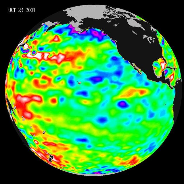
Like fall and winter of 2000, this year NASA Topex/Poseidon satellite data shows that the Pacific ocean continues to be dominated by the strong Pacific Decadal Oscillation, which is larger than the El Niño/La Niña pattern.
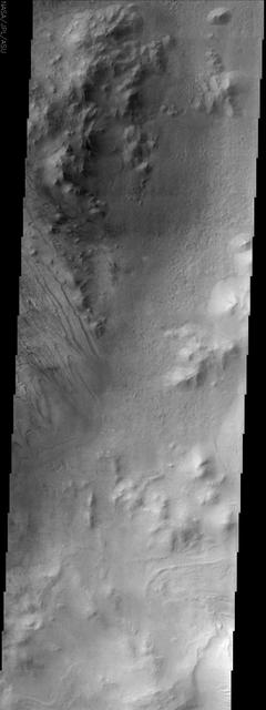
This image from NASA Mars Odyssey spacecraft shows part of Galle Crater. It was taken far enough south and late enough into the southern hemisphere fall to observe water ice clouds partially obscuring the surface.
As spring progresses at the south pole, the surface reacts to the change of season. This image from NASA 2001 Mars Odyssey spacecraft shows a region of the south pole that is monitored throughout spring, summer, and fall at the south pole.
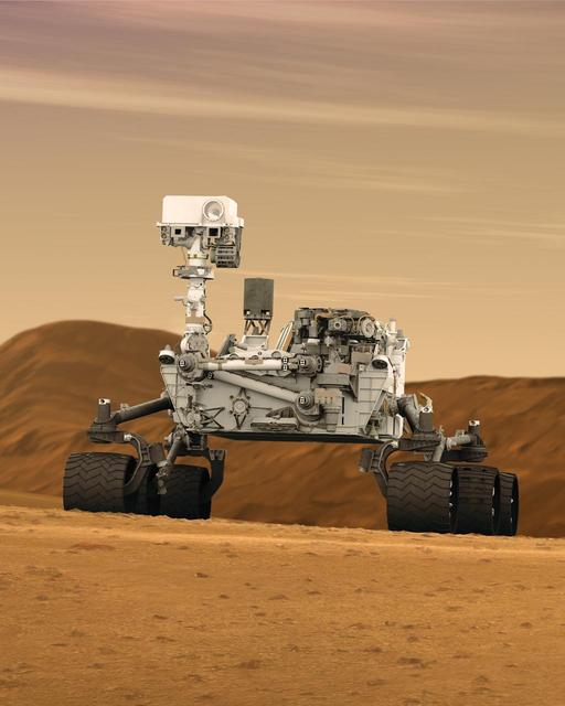
This artist concept features NASA Mars Science Laboratory Curiosity rover, a mobile robot for investigating Mars past or present ability to sustain microbial life. Curiosity is being tested in preparation for launch in the fall of 2011.
Arabia Terra is one of the more dusty regions on Mars, where ever-falling red dust covers the surface allowing only minor variations in color and tone as seen by NASA Mars Reconnaissance Orbiter.
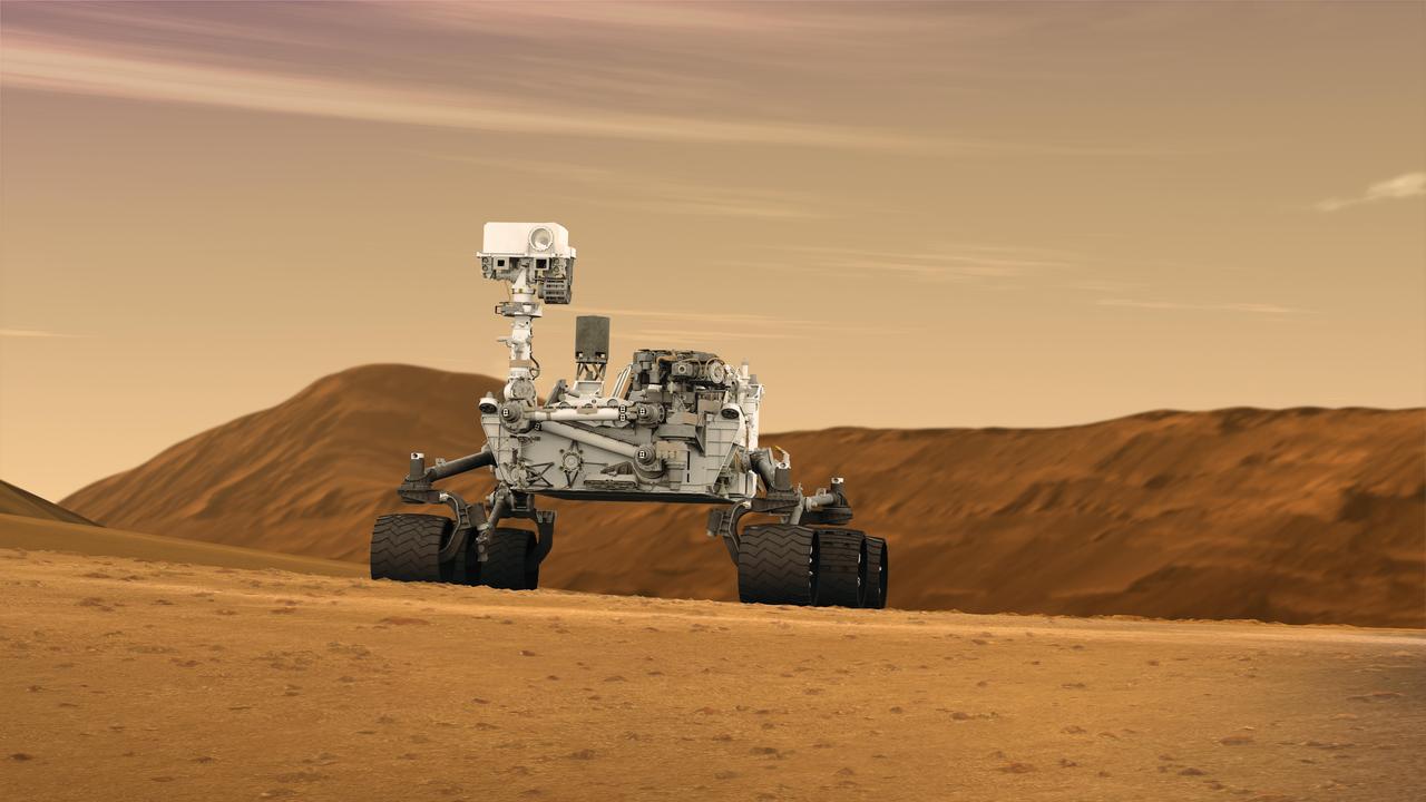
This artist concept features NASA Mars Science Laboratory Curiosity rover, a mobile robot for investigating Mars past or present ability to sustain microbial life. Curiosity is being tested in preparation for launch in the fall of 2011.
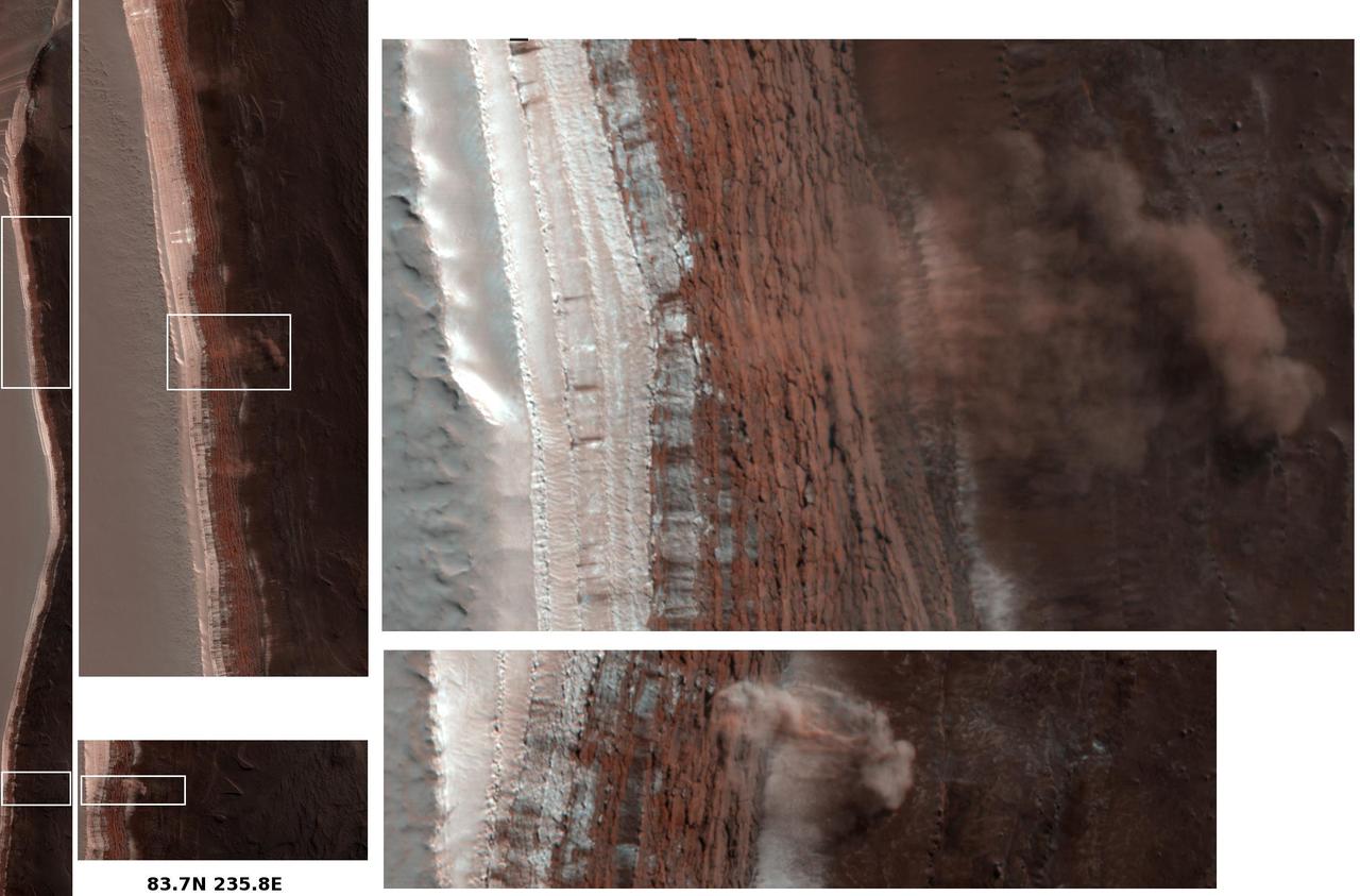
Amazingly, this image has captured at least four Martian avalanches, or debris falls, in action. It was taken on February 19, 2008, by the High Resolution Imaging Science Experiment HiRISE camera on NASA Mars Reconnaissance Orbiter.
Dark slope streaks, like the ones in this unnamed crater in Terra Sabaea, are believed to be formed when surface dust is displaced and the darker rock below is exposed. Rocks falling due to gravity likely formed these streaks.
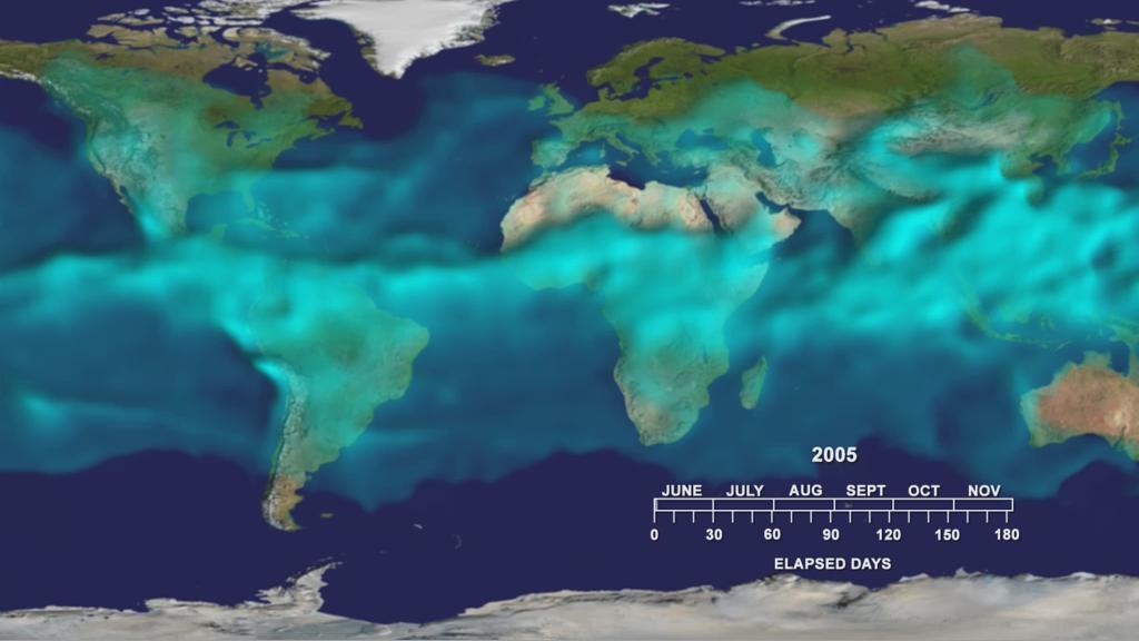
This visualization from the Atmospheric Infrared Sounder AIRS on NASA Aqua satellite shows variations in the three dimensional distribution of water vapor in the atmosphere during the summer and fall of 2005.

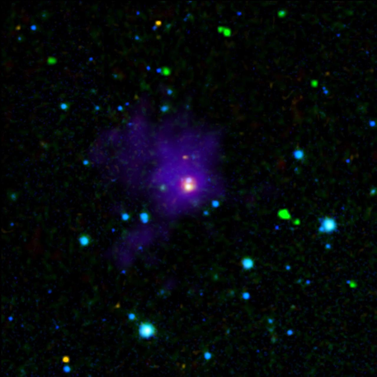
This computer-simulated image shows gas from a tidally shredded star falling into a black hole. Astronomers observed the flare in ultraviolet light using NASA Galaxy Evolution Explorer.
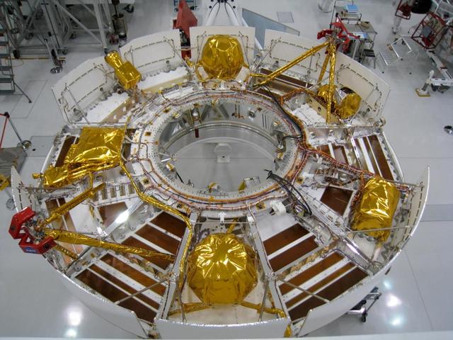
This portion of NASA Mars Science Laboratory spacecraft, called the cruise stage, will do its work during the flight between Earth and Mars after launch in the fall of 2011.
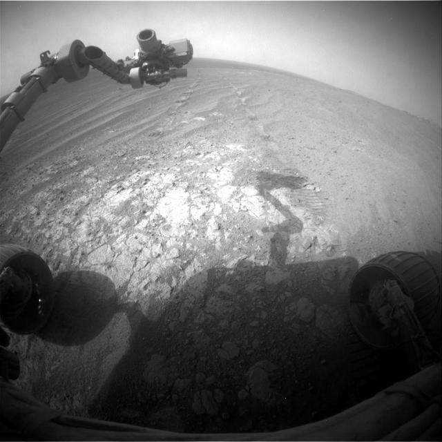
NASA Mars Exploration Rover Opportunity is continuing its traverse southward on the western rim of Endeavour Crater during the fall of 2014, stopping to investigate targets of scientific interest along way.
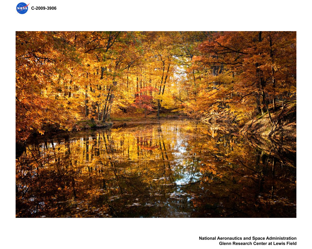
Guerin Pond in the Fall

This two-panel illustration shows a black hole surrounded by a disk of gas, before and after the disk is partially dispersed. In the left panel, the ball of white light above the black hole is the black hole corona, a collection of ultra-hot gas particles that forms as gas from the disk falls into the black hole. The streak of debris falling toward the disk is what remains of a star that was torn apart by the black hole's gravity. The right panel shows the black hole after the debris from the star has dispersed some of the gas in the disk, causing the corona to disappear. https://photojournal.jpl.nasa.gov/catalog/PIA23864
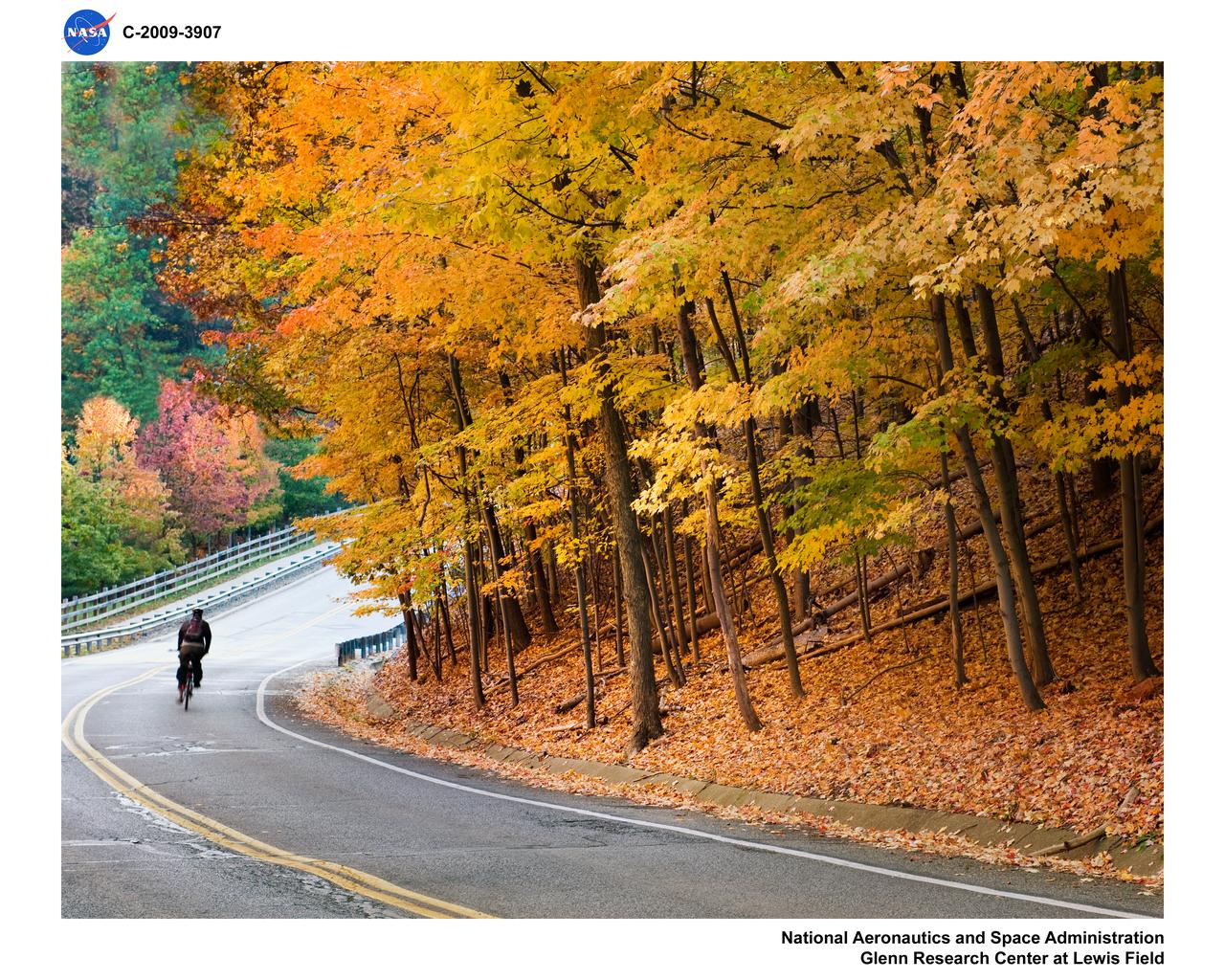
Bicyclist on West Area Road in the Fall
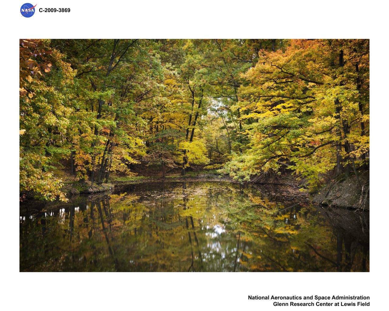
Fall color at Glenn Research Center

This graphic shows the computer simulation of a black hole from start to finish. Plasma is falling slowly toward the black hole in a (at the upper left). The plasma has a magnetic field, shown by the white lines. It picks up speed as it falls toward the hole in b (at the upper right), c (lower left) and d (lower right). However, the rotating black hole twists up space itself (and the magnetic field lines) and ejects electromagnetic power along the north and south poles above the black hole. The red and white color shows the immense electromagnetic power output, which eventually will pick up particles and form squirting jets. This simulation was conducted using supercomputers at Japan's National Institute for Fusion Science. http://photojournal.jpl.nasa.gov/catalog/PIA04206
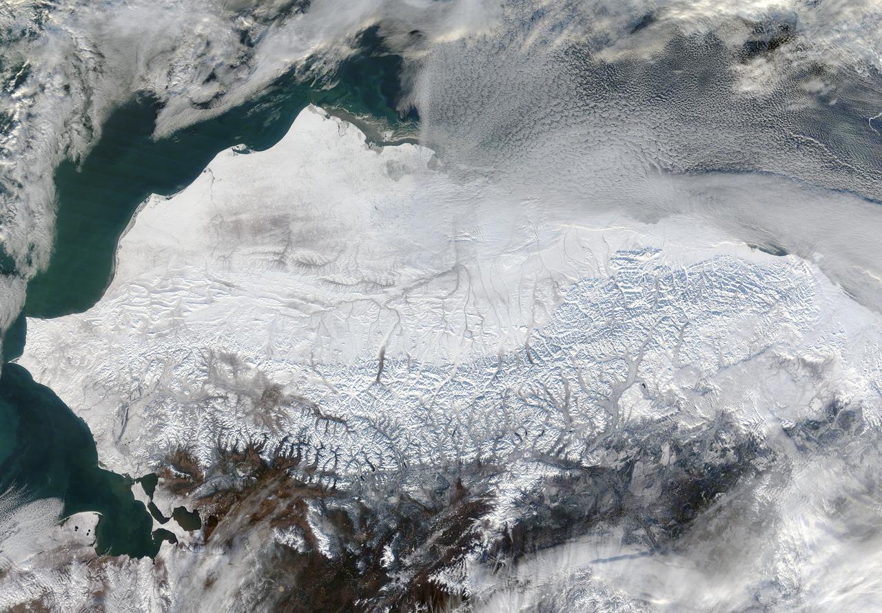
As autumn colors moved across much of the lower forty-eight states in mid-October 2015, winter weather had already arrived in Alaska. The Moderate Resolution Imaging Spectroradiometer (MODIS) aboard NASA’s Terra satellite captured this true-color image of the icy scene on October 16 as it passed over the region. Point Barrow, the northern-most location in the United States sits between the Chukchi Sea (west) and the Beaufort Sea on the east. The rugged peaks of the Brooks Range can be seen along the southern section of the image. North of the Brooks Range the land is almost entirely covered with snow; to the south the tan and browns visible between snow marks uncovered land. Sea ice lies over the waters near the coasts of much of Alaska’s North Slope, especially east of Point Barrow. White cloud banks are notable in the northeast and southeast sections of the image. Credit: NASA/GSFC/Jeff Schmaltz/MODIS Land Rapid Response Team <b><a href="http://www.nasa.gov/audience/formedia/features/MP_Photo_Guidelines.html" rel="nofollow">NASA image use policy.</a></b> <b><a href="http://www.nasa.gov/centers/goddard/home/index.html" rel="nofollow">NASA Goddard Space Flight Center</a></b> enables NASA’s mission through four scientific endeavors: Earth Science, Heliophysics, Solar System Exploration, and Astrophysics. Goddard plays a leading role in NASA’s accomplishments by contributing compelling scientific knowledge to advance the Agency’s mission. <b>Follow us on <a href="http://twitter.com/NASAGoddardPix" rel="nofollow">Twitter</a></b> <b>Like us on <a href="http://www.facebook.com/pages/Greenbelt-MD/NASA-Goddard/395013845897?ref=tsd" rel="nofollow">Facebook</a></b> <b>Find us on <a href="http://instagrid.me/nasagoddard/?vm=grid" rel="nofollow">Instagram</a></b>
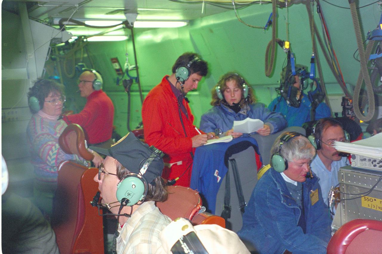
C-141 KAO - Fall 1993 Foster Teachers Flight

Research pilots from the NASA Dryden Flight Research Center, Edwards, Calif., tested a prototype two-part helmet. Built by Gentex Corp., Carbondale, Pa., the helmet was evaluated by five NASA pilots during the summer and fall of 2002. The objective was to obtain data on helmet fit, comfort and functionality. The inner helmet of the modular system is fitted to the individual crewmember. The outer helmet features a fully integrated spectral mounted helmet display and a binocular helmet mounted display. The helmet will be adaptable to all flying platforms. The Dryden evaluation was overseen by the Center's Life Support office. Assessments have taken place during normal proficiency flights and some air-to-air combat maneuvering. Evaluation platforms included the F-18, B-52 and C-12. The prototype helmet is being developed by the Naval Air Science and Technology Office and the Aircrew Systems Program Office, Patuxent River, Md.

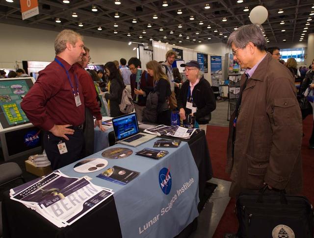
American Geophysical Union 'AGU' Fall Meeting in San Francisco Moscone Center, California.

American Geophysical Union 'AGU' Fall Meeting in San Francisco Moscone Center, California.

American Geophysical Union 'AGU' Fall Meeting in San Francisco Moscone Center, California.

American Geophysical Union 'AGU' Fall Meeting in San Francisco Moscone Center, California.

American Geophysical Union 'AGU' Fall Meeting in San Francisco Moscone Center, California.

American Geophysical Union 'AGU' Fall Meeting in San Francisco Moscone Center, California.

American Geophysical Union 'AGU' Fall Meeting in San Francisco Moscone Center, California.

American Geophysical Union 'AGU' Fall Meeting in San Francisco Moscone Center, California.
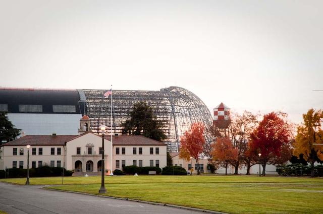
Lunar Science Institute, Bldg-17 at NASA Research Park in the fall with Hangar One deskinning project going on in backbround.

American Geophysical Union 'AGU' Fall Meeting in San Francisco Moscone Center, California.

American Geophysical Union 'AGU' Fall Meeting in San Francisco Moscone Center, California.

American Geophysical Union 'AGU' Fall Meeting in San Francisco Moscone Center, California.

Lunar Science Institute, Bldg-17 at NASA Research Park in the fall with Hangar One deskinning project going on in backbround.
American Geophysical Union 'AGU' Fall Meeting in San Francisco Moscone Center, California.

American Geophysical Union 'AGU' Fall Meeting in San Francisco Moscone Center, California.
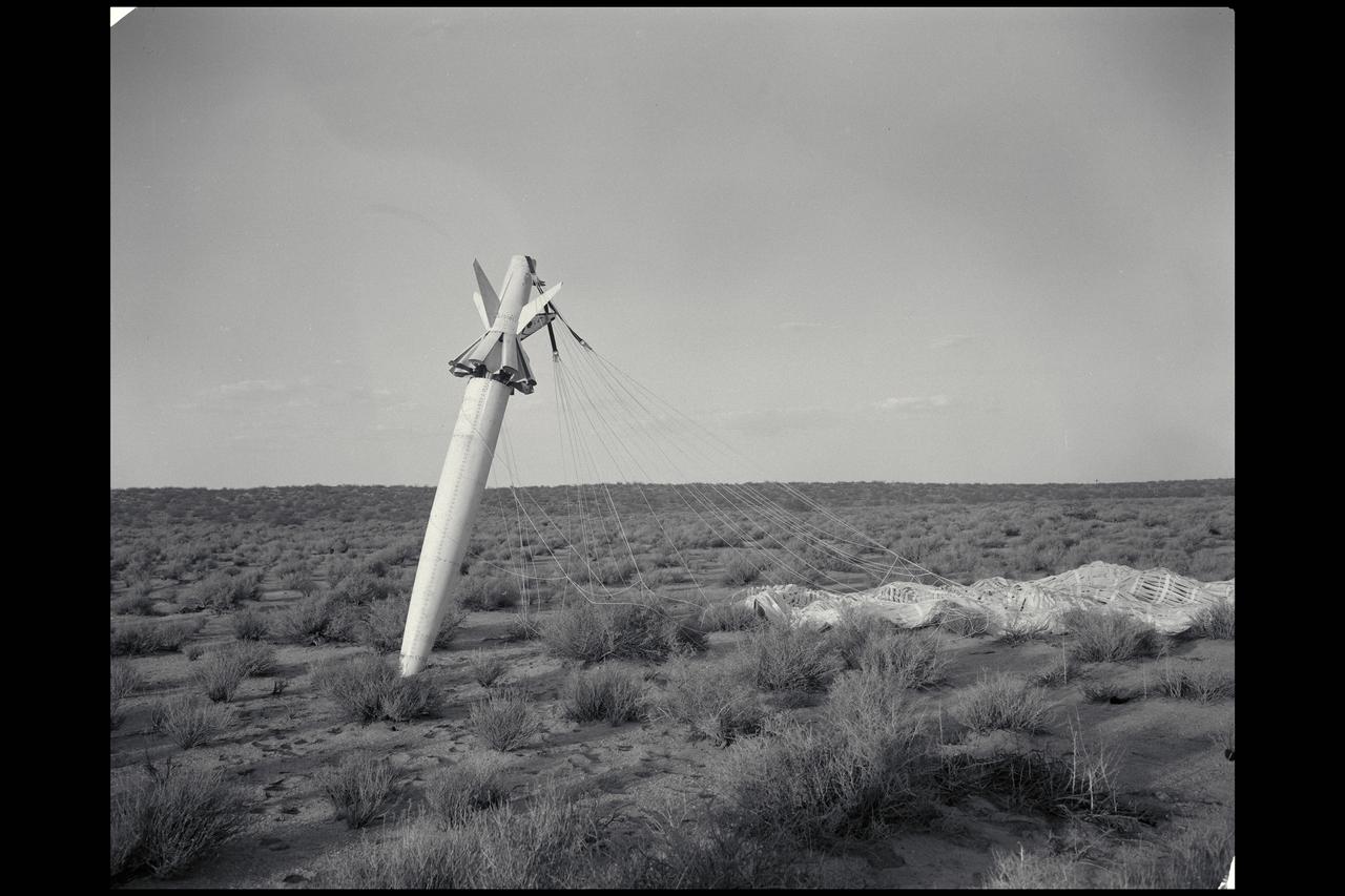
NACA photograpehr Drop 2 SI-2 body in free fall flight (SI-II missile)