
Eric Hooks, Deputy Administrator of the Federal Emergency Management Agency (FEMA), speaks before the ribbon cutting ceremony to open NASA’s Earth Information Center, Wednesday, June 21, 2023, at the Mary W. Jackson NASA Headquarters building in Washington. The Earth Information Center is new immersive experience that combines live data sets with cutting-edge data visualization and storytelling to allow visitors to see how our planet is changing. Photo Credit: (NASA/Joel Kowsky)
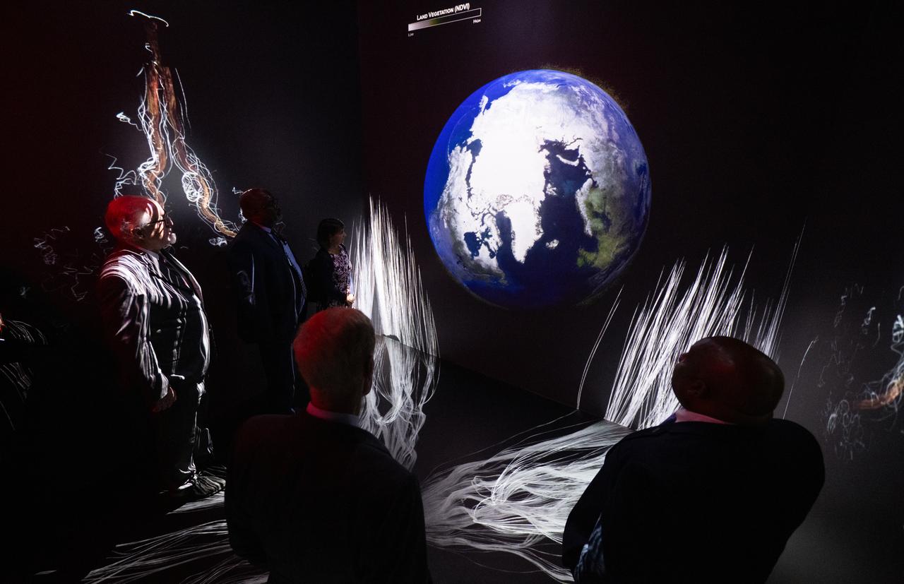
NASA Administrator Bill Nelson, Michael Morgan, Assistant Secretary of Commerce for Environmental Observation and Prediction at the National Oceanic and Atmospheric Administration (NOAA), Marlen Eve, Deputy Administrator for the Agricultural Research Service at the U.S. Department of Agriculture (USDA), and Eric Hooks, Deputy Administrator of the Federal Emergency Management Agency (FEMA), are seen as they watch “Space for Earth,” the immersive audio-visual installation in NASA’s Earth Information Center, following the ribbon cutting ceremony, Wednesday, June 21, 2023, at the Mary W. Jackson NASA Headquarters building in Washington. The Earth Information Center is new immersive experience that combines live data sets with cutting-edge data visualization and storytelling to allow visitors to see how our planet is changing. Photo Credit: (NASA/Joel Kowsky)
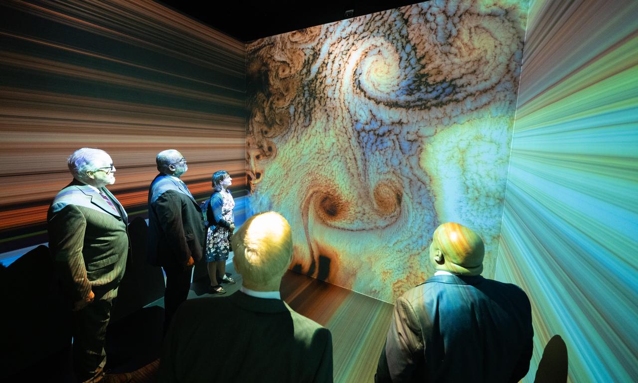
NASA Administrator Bill Nelson, Michael Morgan, Assistant Secretary of Commerce for Environmental Observation and Prediction at the National Oceanic and Atmospheric Administration (NOAA), Marlen Eve, Deputy Administrator for the Agricultural Research Service at the U.S. Department of Agriculture (USDA), and Eric Hooks, Deputy Administrator of the Federal Emergency Management Agency (FEMA), are seen as they watch “Space for Earth,” the immersive audio-visual installation in NASA’s Earth Information Center, following the ribbon cutting ceremony, Wednesday, June 21, 2023, at the Mary W. Jackson NASA Headquarters building in Washington. The Earth Information Center is new immersive experience that combines live data sets with cutting-edge data visualization and storytelling to allow visitors to see how our planet is changing. Photo Credit: (NASA/Joel Kowsky)
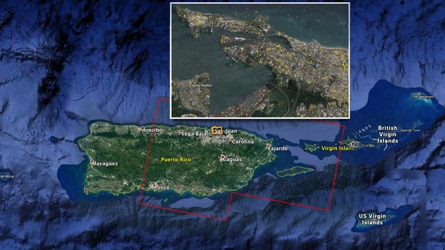
The Advanced Rapid Imaging and Analysis (ARIA) team at NASA's Jet Propulsion Laboratory in Pasadena, California, and Caltech, also in Pasadena, created this Damage Proxy Map (DPM) depicting areas of Eastern Puerto Rico that are likely damaged (shown by red and yellow pixels) as a result of Hurricane Maria (a Category 4 hurricane at landfall in Puerto Rico on Sept. 20, 2017). The map is derived from synthetic aperture radar (SAR) images from the Copernicus Sentinel-1A and Sentinel-1B satellites, operated by the European Space Agency (ESA). The images were taken before (March 25, 2017) and after (Sept. 21, 2017) the storm's landfall. The map was delivered to responding agencies, including the Federal Emergency Management Agency (FEMA), on Sept. 22, 2017. FEMA combined the map with building infrastructure data to estimate a damage density map, which was sent to its Urban Search and Rescue teams in the field in Puerto Rico. The map covers an area of 105 by 60 miles (169 by 96 kilometers), shown by the large red polygon in the figure. The inset, denoted by the orange rectangle, shows the extent of damage in and around the capital city of San Juan. Each pixel measures about 98 feet (30 meters) across. The color variation from yellow to red indicates increasingly more significant ground surface change. Preliminary validation was done by comparing the map with anecdotal reports of damage. This damage proxy map should be used as guidance to identify damaged areas, and may be less reliable over vegetated and flooded areas. Sentinel-1 data were accessed through the Copernicus Open Access Hub. The image contains modified Copernicus Sentinel data (2017), processed by ESA and analyzed by the NASA-JPL/Caltech ARIA team. This research was carried out at JPL under a contract with NASA. https://photojournal.jpl.nasa.gov/catalog/PIA21964