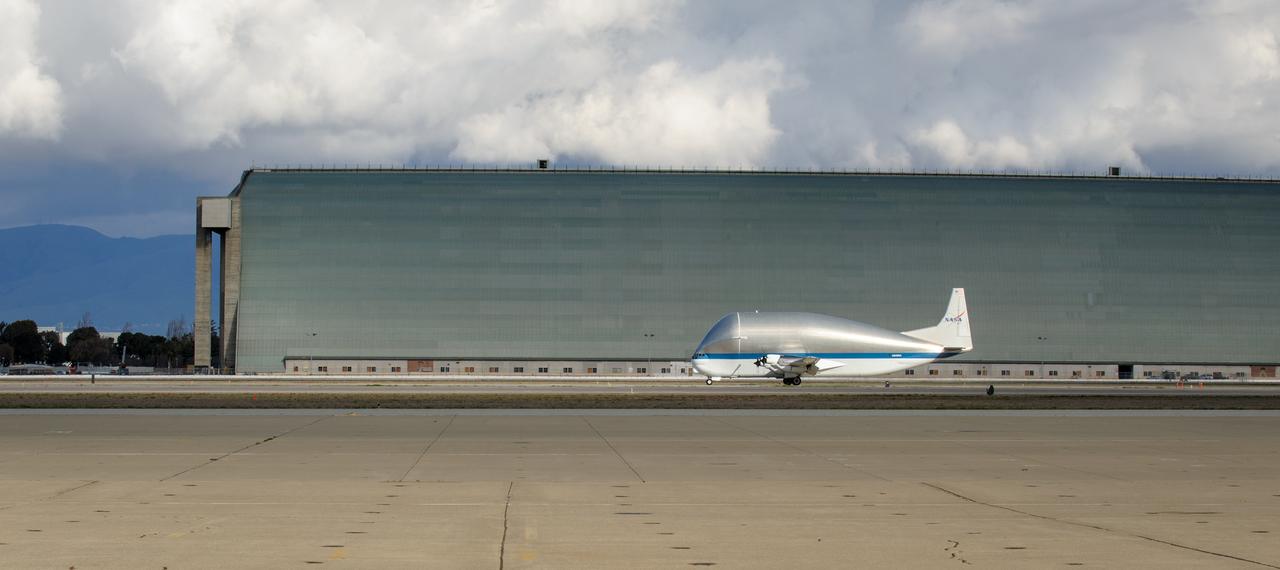
NASA N941NA taxies in front of Hangar 2 at Moffett Field.
NASA N941NA taxies in front of Hangar 2 at Moffett Field.

NASA N941NA lift off from Ames Research Center at Moffett Field, it is the last Super Guppy still flying.
Secondary Field
Secondary Field
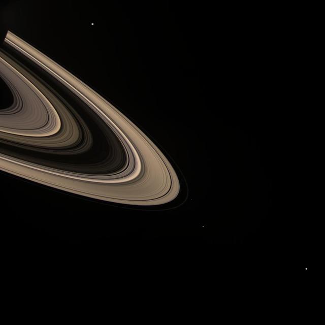
Field of Moons
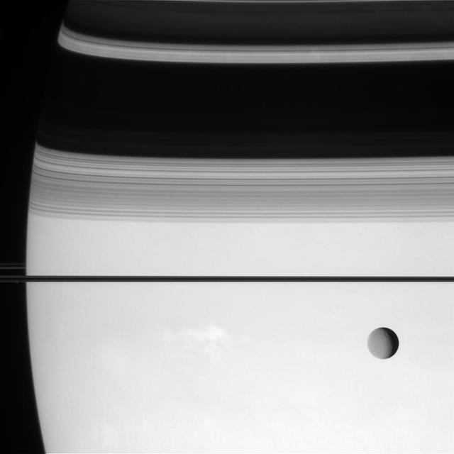
Depth of Field
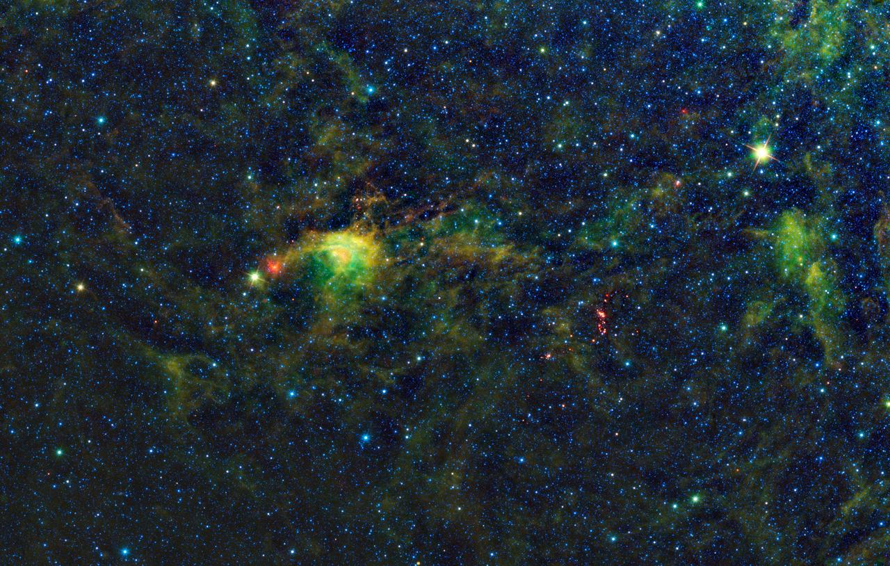
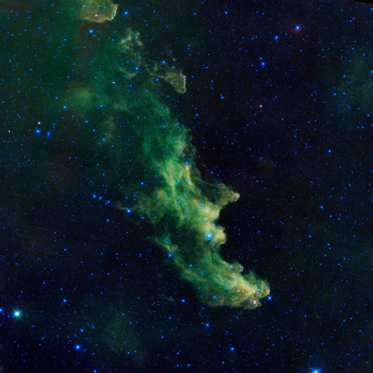
Field of Fans
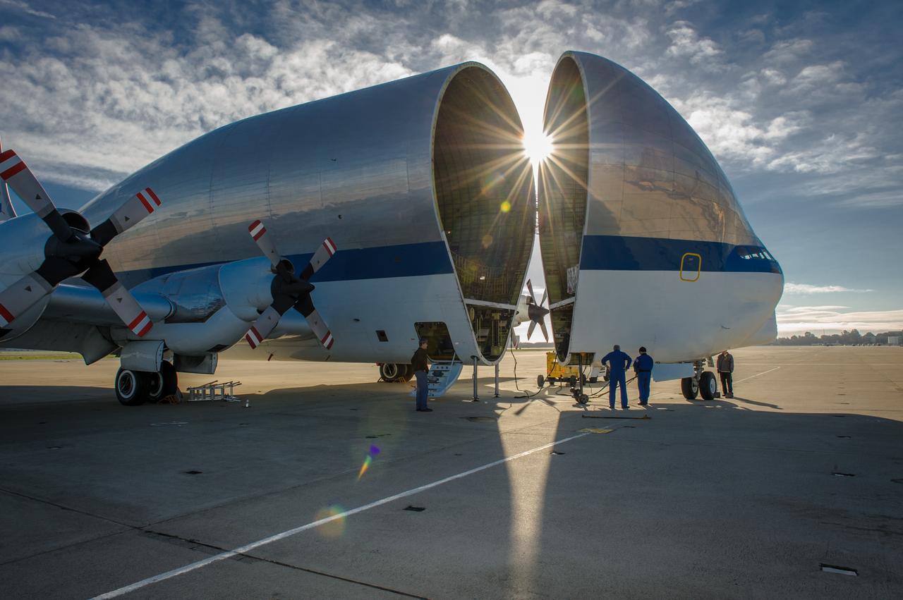
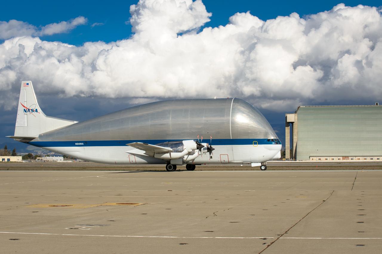
NASA N941NA Superguppy at Moffett Field. Cargo is loaded into the Super Guppy when the aircraft's "fold-away" nose rotates 110 degrees to the left, allowing unobstructed access to the 25 foot diameter fuselage.
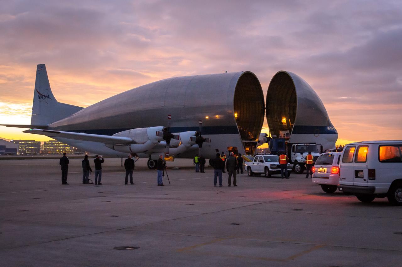
NASA N941NA Superguppy lands at the Moffett Field. Cargo is loaded into the Super Guppy when the aircraft's "fold-away" nose rotates 110 degrees to the left, allowing unobstructed access to the 25 foot diameter fuselage.
NASA N941NA parked in front of Hangar 1 at Moffett Field. Cargo is loaded into the Super Guppy when the aircraft's "fold-away" nose rotates 110 degrees to the left, allowing unobstructed access to the 25 foot diameter fuselage.

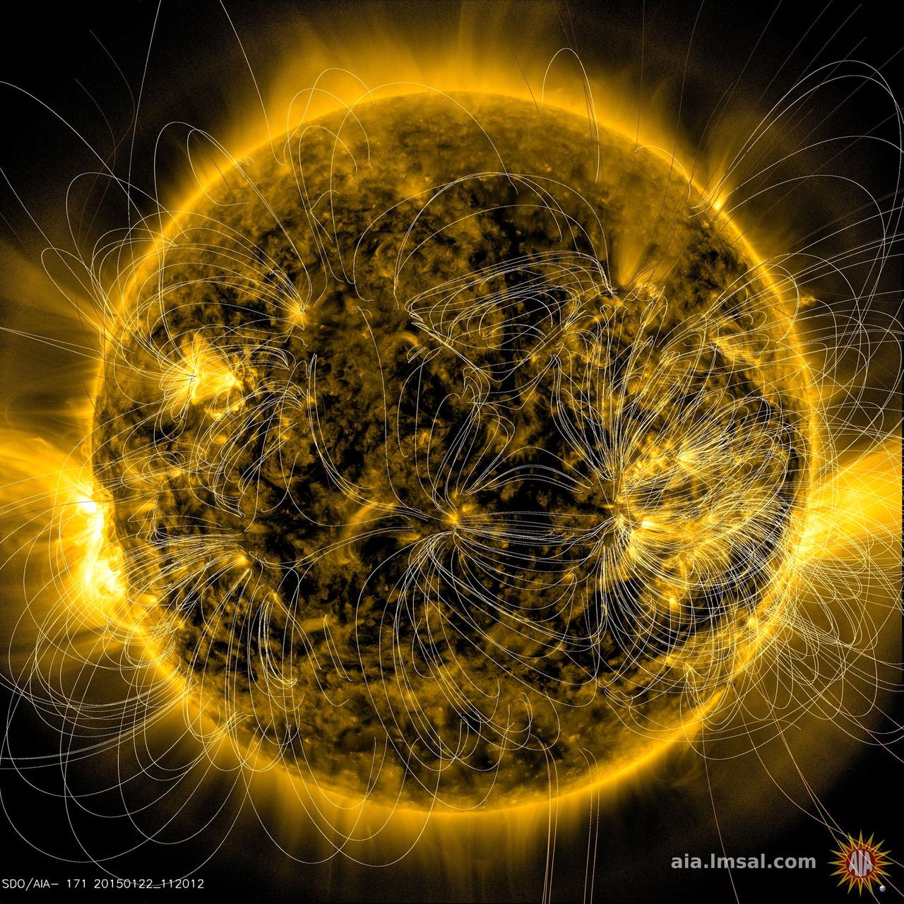
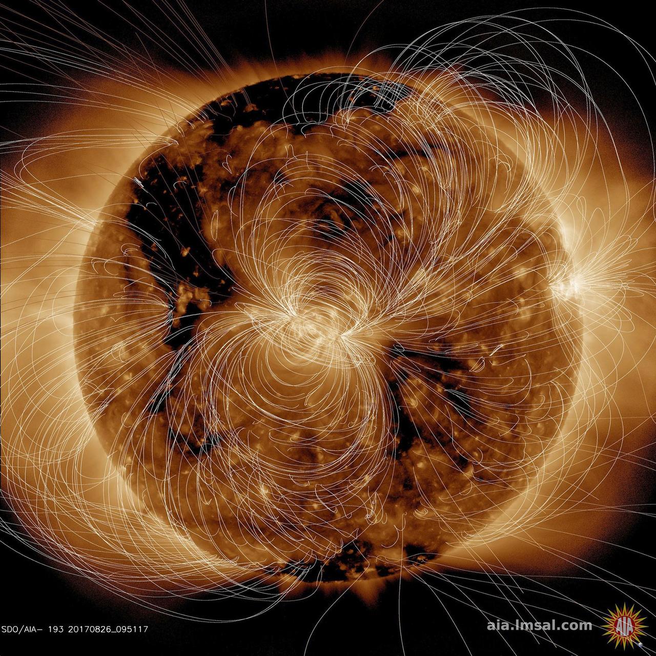
This illustration lays a depiction of the sun's magnetic fields over an image captured by NASA’s Solar Dynamics Observatory on March 12, 2016. The complex overlay of lines can teach scientists about the ways the sun's magnetism changes in response to the constant movement on and inside the sun. Note how the magnetic fields are densest near the bright spots visible on the sun – which are magnetically strong active regions – and many of the field lines link one active region to another. This magnetic map was created using the PFSS – Potential Field Source Surface – model, a model of the magnetic field in the sun’s atmosphere based on magnetic measurements of the solar surface. The underlying image was taken in extreme ultraviolet wavelengths of 171 angstroms. This type of light is invisible to our eyes, but is colorized here in gold. Credits: NASA/SDO/AIA/LMSAL <b><a href="http://www.nasa.gov/audience/formedia/features/MP_Photo_Guidelines.html" rel="nofollow">NASA image use policy.</a></b> <b><a href="http://www.nasa.gov/centers/goddard/home/index.html" rel="nofollow">NASA Goddard Space Flight Center</a></b> enables NASA’s mission through four scientific endeavors: Earth Science, Heliophysics, Solar System Exploration, and Astrophysics. Goddard plays a leading role in NASA’s accomplishments by contributing compelling scientific knowledge to advance the Agency’s mission. <b>Follow us on <a href="http://twitter.com/NASAGoddardPix" rel="nofollow">Twitter</a></b> <b>Like us on <a href="http://www.facebook.com/pages/Greenbelt-MD/NASA-Goddard/395013845897?ref=tsd" rel="nofollow">Facebook</a></b> <b>Find us on <a href="http://instagrid.me/nasagoddard/?vm=grid" rel="nofollow">Instagram</a></b>
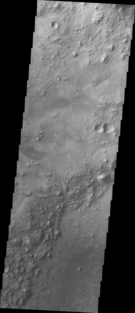
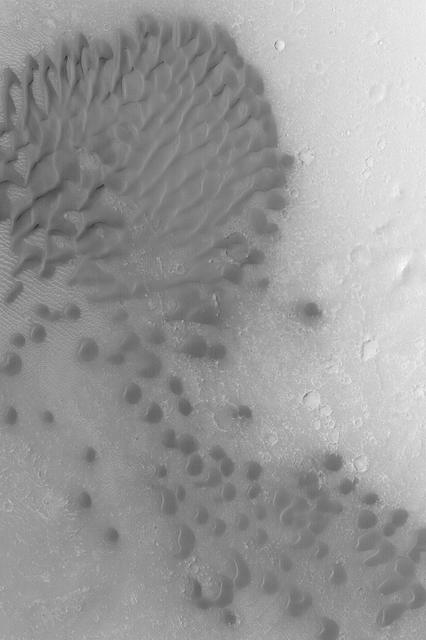
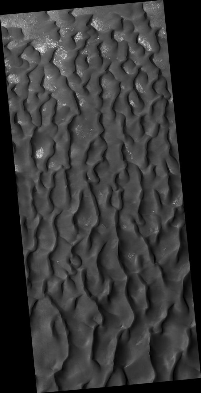
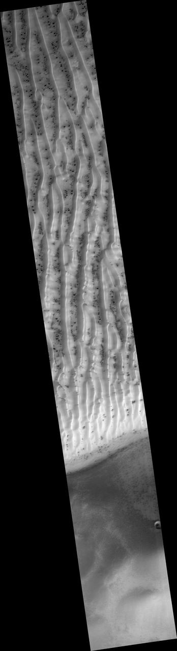
Dune Fields of Terra Cimmeria
Dune Field in Nili Pateria
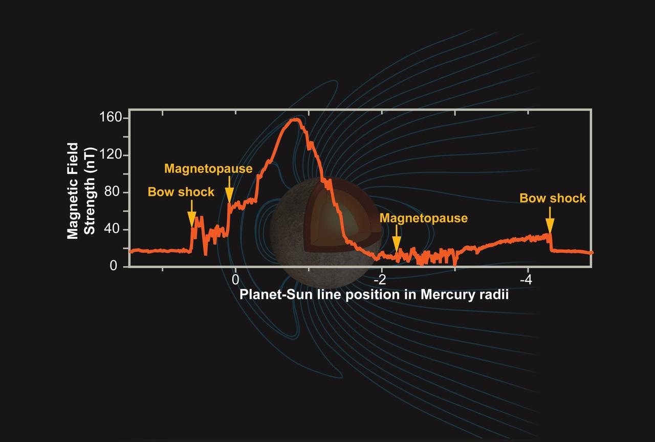
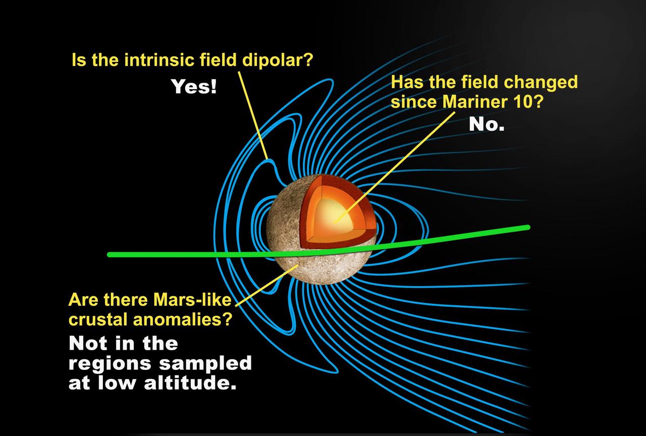
Mercury Magnetic Field
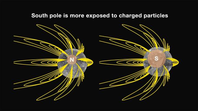
Mercury Magnetic Field Lines
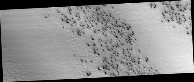
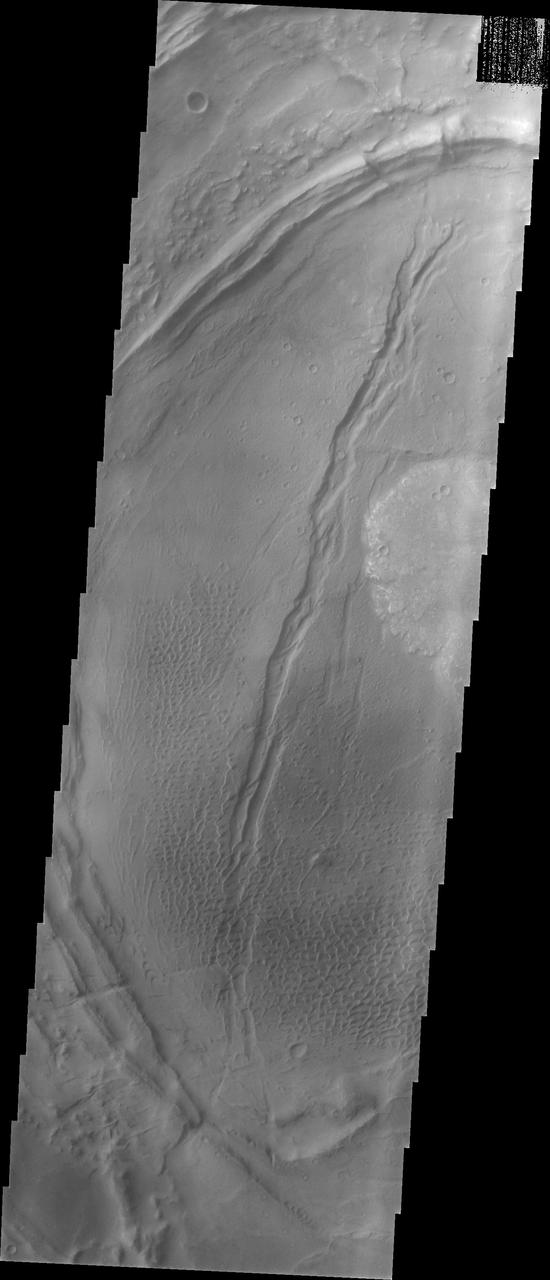
A Field of Secondary Craters
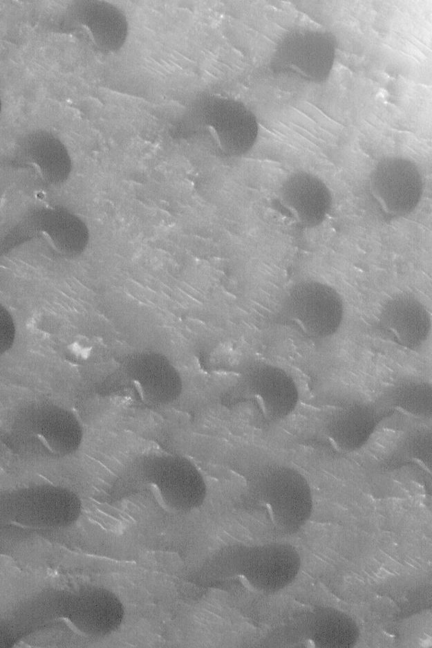
Holden Crater Dune Field
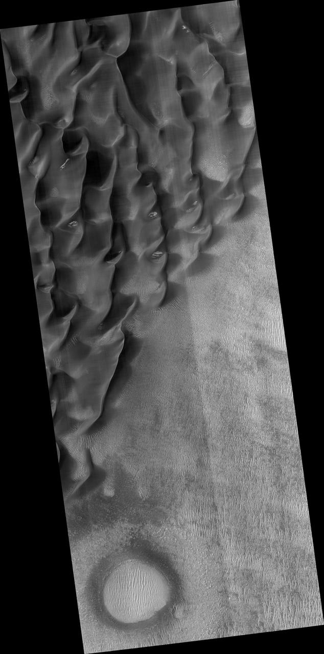
Crater Floor Dune Field
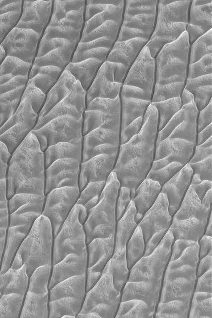
Mid-latitude Dune Field
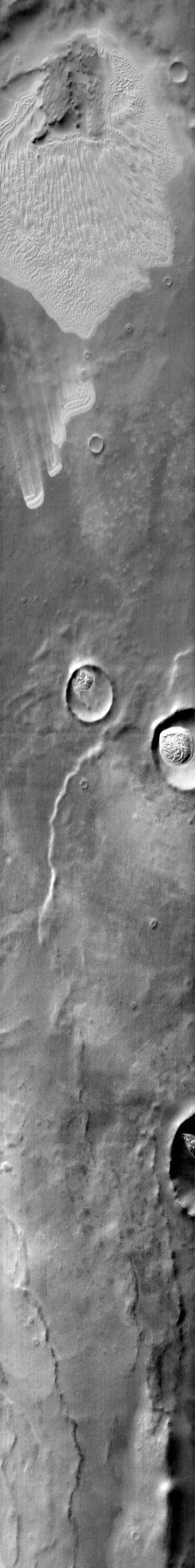
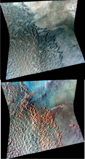
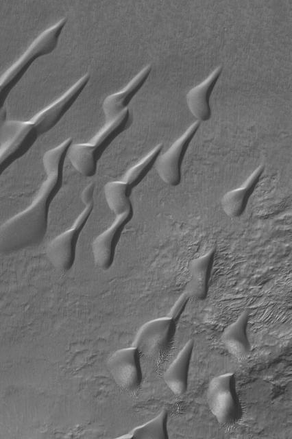
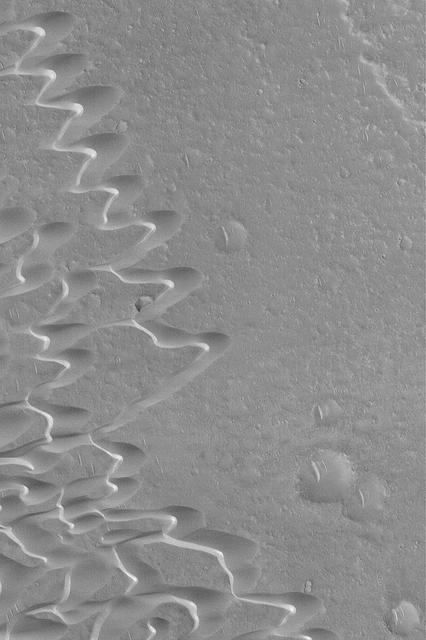
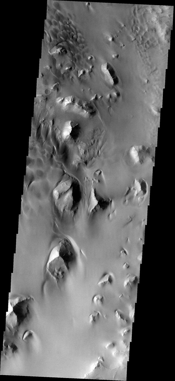
Nili Patera Dune Field
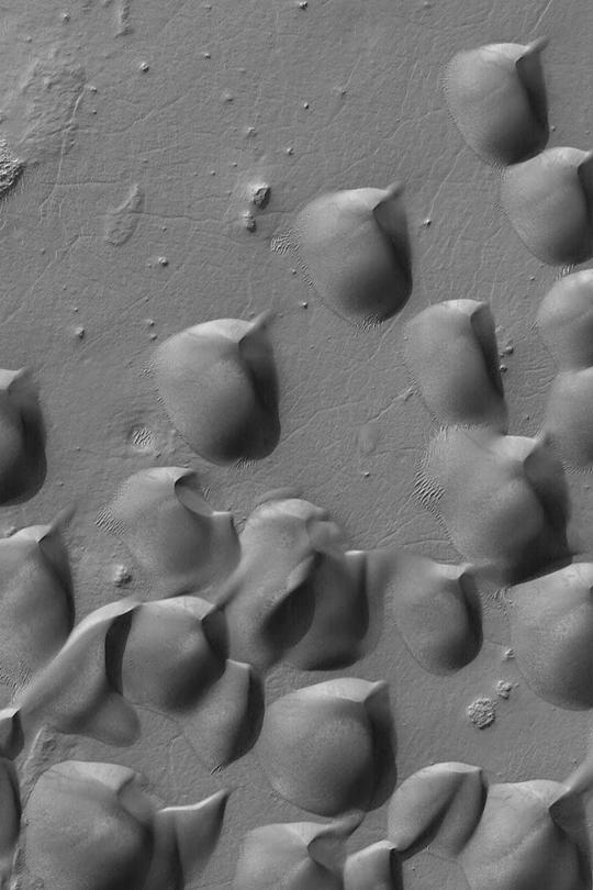
Wirtz Crater Dune Field
Intracrater Dune Field
Syrtis Major Dune Field
Peridier Dune Field
Proctor Crater Dune Field
Kaiser Crater Dune Field
Frosty Dune Field
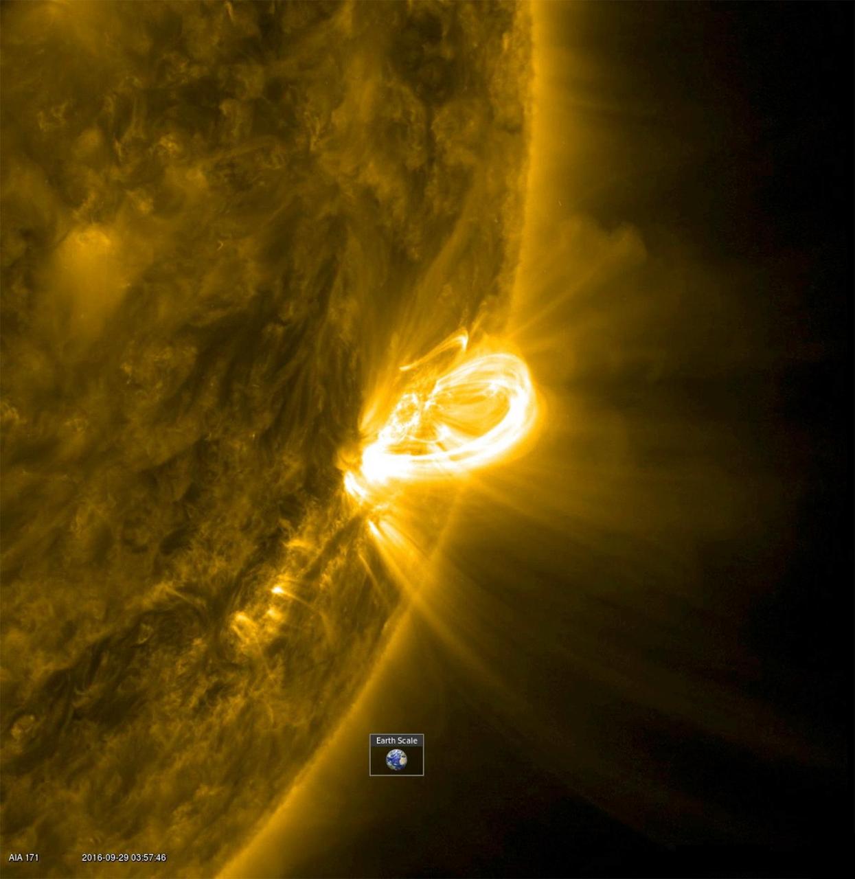
When an active region rotated into a profile view, SDO was able to capture the magnificent loops arching above an active region (Sept. 28-29, 2016). Active region are areas of strong magnetic fields. The magnetic field lines above these regions are illuminated by charged particles spiraling along them. The images were taken in a wavelength of extreme ultraviolet light. The video covers 12 hours of activity. The Earth was inset to give a sense of the scale of these towering arches. Movies are available at http://photojournal.jpl.nasa.gov/catalog/PIA21101
Martian Dune Field http://photojournal.jpl.nasa.gov/catalog/PIA00393
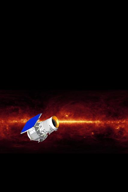
NASA Wide-field Infrared Survey Explorer mission will survey the entire sky in a portion of the electromagnetic spectrum called the mid-infrared with far greater sensitivity than any previous mission or program ever has.
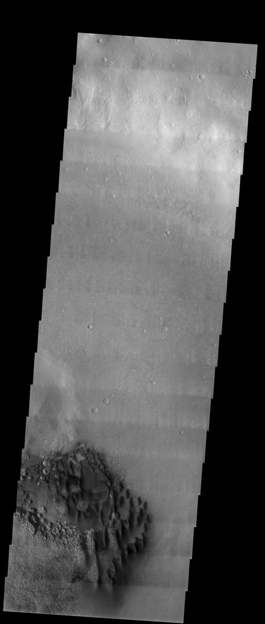
Dune Field in a Southern Highlands Crater
Sand Dune Field in Richardson Crater
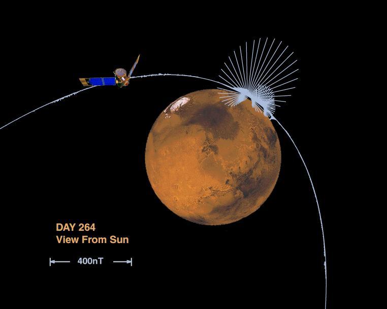
Orientation and Magnitude of Mars Magnetic Field

Mars Crustal Magnetic Field Remnants
This large sand sheet and dune field is located on the floor of Juventae Chasma
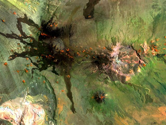
Situated in the southern Andes Mountains, the Payún volcanic field of Argentina is a complex landscape that formed over hundreds of thousands of years. Sprawling over 5,200 square kilometers (2,000 square miles), Payún is a massive shield volcano—a broad formation resembling an ancient warrior shield. This false-color image is a composite of observations acquired on February 7 and March 20, 2001 by the Enhanced Thematic Mapper Plus on the Landsat 7 satellite. It was made from a combination of visible and infrared light, where green indicates vegetation, black indicates lava flows, and orange is bare rock rich in iron oxides. Part of the back-arc volcanism of the Andes, Payún lies about 530 kilometers (330 miles) east from where the Nazca plate subducts below the South America plate. Not surprisingly, a volcanic zone extends over some 1,000 kilometers (600 miles) north-to-south in this region. According to a study published in 2010, the regional geology and chemical composition of the rocks indicate that the volcanic field likely formed within the past 300,000 years. The dominant feature of the volcanic field is Payún Matru, an elliptical caldera measuring roughly 9 by 7 kilometers (6 by 4 miles). Geologists surmise that the caldera formed after the old magma chamber emptied and the summit collapsed. Southwest of the caldera is a stratovolcano composed of alternating layers of compacted ash, hardened lava, and rocks ejected during previous eruptions. This stratovolcano, Payún, rises to 3,680 meters (12,073 feet) above sea level. (The entire volcanic field sits at 2,000 meters, or 6,600 feet.) The stratovolcano may be the most prominent feature in the volcanic field but it is by no means the only one. More than 300 eruptive features litter the shield volcano, most of them occupying an east-west line. West of Payún Matru is an area known as Los Volcanes, a mass of strombolian cones and basaltic lava flows. Image courtesy Michael P. Taylor, Landsat Data Continuity Mission Project Office, NASA Goddard Space Flight Center. Caption by Michon Scott with information from Michael Abrams, NASA Jet Propulsion Laboratory. Instrument: Landsat 7 - ETM+ To read more go to: <a href="http://1.usa.gov/UO8CbF" rel="nofollow">1.usa.gov/UO8CbF</a> Credit: <b><a href="http://www.earthobservatory.nasa.gov/" rel="nofollow"> NASA Earth Observatory</a></b> <b><a href="http://www.nasa.gov/audience/formedia/features/MP_Photo_Guidelines.html" rel="nofollow">NASA image use policy.</a></b> <b><a href="http://www.nasa.gov/centers/goddard/home/index.html" rel="nofollow">NASA Goddard Space Flight Center</a></b> enables NASA’s mission through four scientific endeavors: Earth Science, Heliophysics, Solar System Exploration, and Astrophysics. Goddard plays a leading role in NASA’s accomplishments by contributing compelling scientific knowledge to advance the Agency’s mission. <b>Follow us on <a href="http://twitter.com/NASA_GoddardPix" rel="nofollow">Twitter</a></b> <b>Like us on <a href="http://www.facebook.com/pages/Greenbelt-MD/NASA-Goddard/395013845897?ref=tsd" rel="nofollow">Facebook</a></b> <b>Find us on <a href="http://instagram.com/nasagoddard?vm=grid" rel="nofollow">Instagram</a></b>

NASA Astronaut Frank Rubio trains for his upcoming International Space Station mission in a T-38 jet at Ellington Field in Houston, Texas.
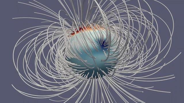
This animation illustrates Jupiter's magnetic field at a single moment in time. The Great Blue Spot, an-invisible-to-the-eye concentration of magnetic field near the equator, stands out as a particularly strong feature. The gray lines (called field lines) show the field's direction in space, and the deepness of the color corresponds to the strength of the magnetic field (with dark red and dark blue for regions with strongly positive and strongly negative fields, respectively). The animation first appeared in a Sept. 5, 2018, paper in the Journal Nature. Animation available at https://photojournal.jpl.nasa.gov/catalog/PIA23229.
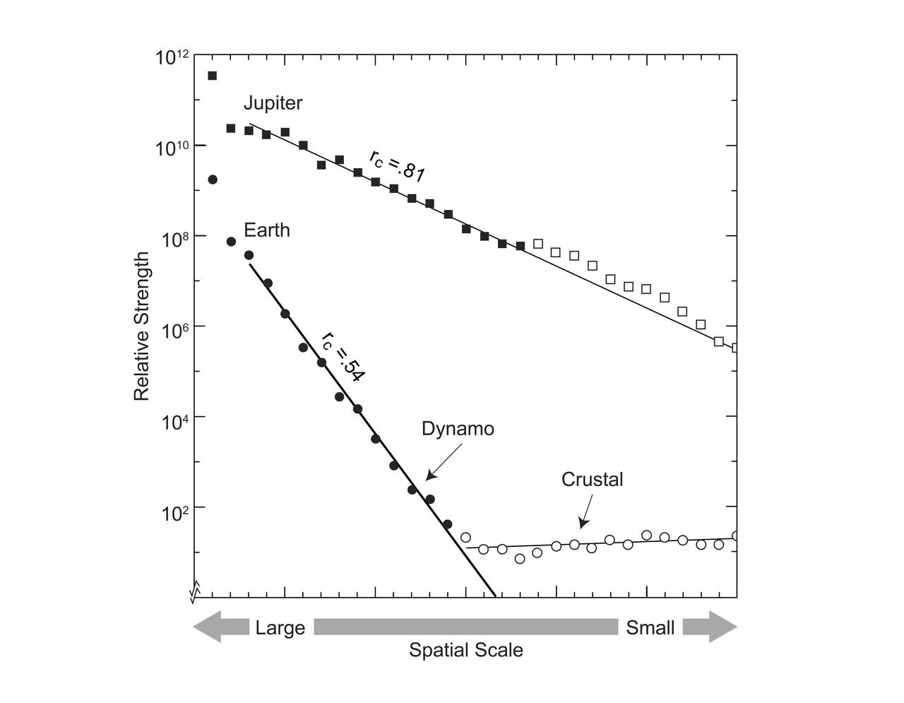
This graphic compares the magnetic fields of Earth and Jupiter, characterizing the field on the surface of each planet in terms of spatial scale, with large scale to the left, and small scale to the right. The linear progression of terms characterizing Earth's field identifies a dynamo core radius at 0.54 planet radius and crustal magnetization at smaller scales. By analogy, the new Jupiter model identifies a dynamo core radius at 0.81 planet radius, in the convective metallic hydrogen just beneath a zone stabilized by helium rain. https://photojournal.jpl.nasa.gov/catalog/PIA25064
Scientists have developed a way to produce models of where the magnetic field lines are several times each day. Here we have created a time-lapse version of these models over four days (2-3 each day) to give you a peek at how these change over time. The spiraling arcs of magnetic field lines emerge from active regions and connect back to areas with the opposite polarity. The field lines are more concentrated where regions are more magnetically intense. And of course, they rotate with the rotation of the Sun. Credit: NASA/Solar Dynamics Observatory <b><a href="http://www.nasa.gov/audience/formedia/features/MP_Photo_Guidelines.html" rel="nofollow">NASA image use policy.</a></b> <b><a href="http://www.nasa.gov/centers/goddard/home/index.html" rel="nofollow">NASA Goddard Space Flight Center</a></b> enables NASA’s mission through four scientific endeavors: Earth Science, Heliophysics, Solar System Exploration, and Astrophysics. Goddard plays a leading role in NASA’s accomplishments by contributing compelling scientific knowledge to advance the Agency’s mission. <b>Follow us on <a href="http://twitter.com/NASAGoddardPix" rel="nofollow">Twitter</a></b> <b>Like us on <a href="http://www.facebook.com/pages/Greenbelt-MD/NASA-Goddard/395013845897?ref=tsd" rel="nofollow">Facebook</a></b> <b>Find us on <a href="http://instagram.com/nasagoddard?vm=grid" rel="nofollow">Instagram</a></b>
This 2001 Mars Odyssey image shows the dune field in Nili Patera.
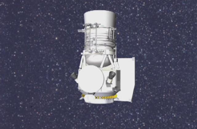
Artist concept of Wide-field Infrared Survey Explorer. A new NASA mission will scan the entire sky in infrared light in search of nearby cool stars, planetary construction zones and the brightest galaxies in the universe. http://photojournal.jpl.nasa.gov/catalog/PIA06927

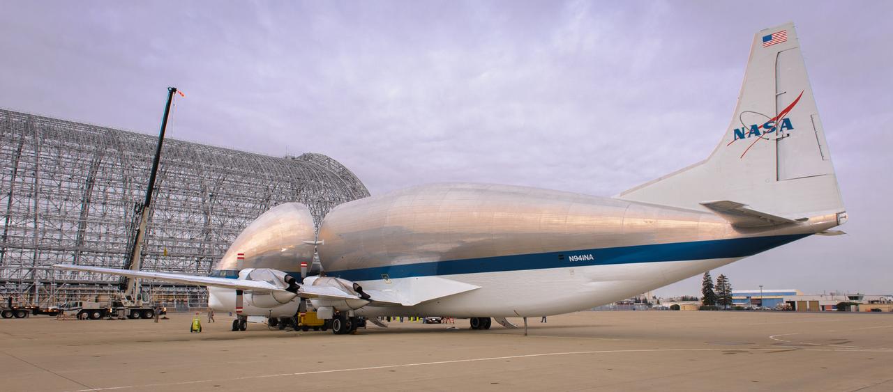
NASA N941NA is the last Super Guppy Turbine Cargo Airplane in service.
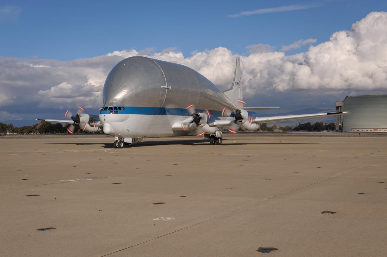
NASA N941NA is the last Super Guppy Turbine Cargo Airplane in service.
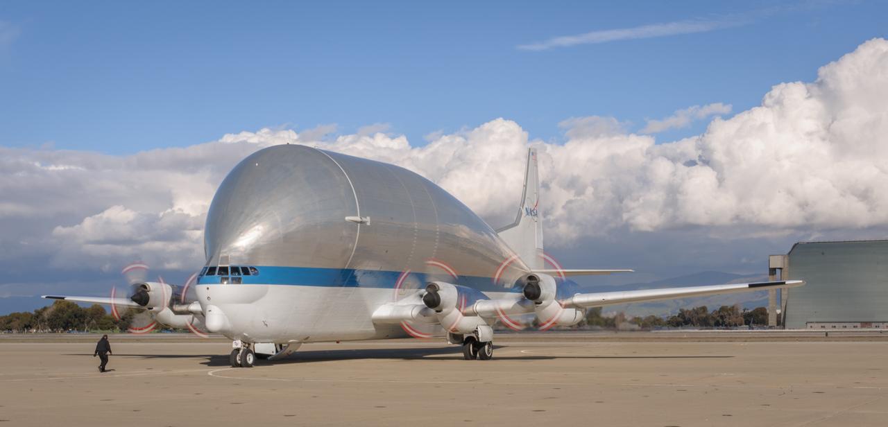
NASA N941NA is the last Super Guppy Turbine Cargo Airplane in service.

NASA astronaut candidate Raja Chari poses for a portrait, Friday, July 12, 2019 at Ellington Field in Houston, Texas. Photo Credit: (NASA/Bill Ingalls)

NASA astronaut candidate Raja Chari poses for a portrait, Friday, July 12, 2019 at Ellington Field in Houston, Texas. Photo Credit: (NASA/Bill Ingalls)
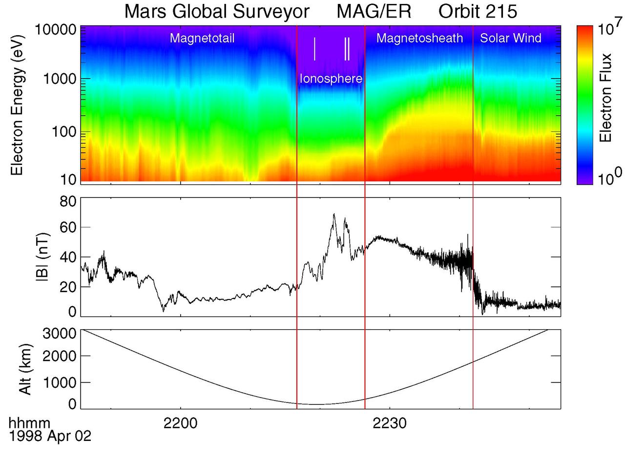
Electron and Magnetic Field Observations MAG/ER
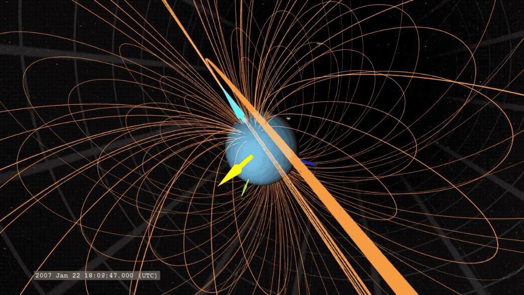
An animated GIF showing Uranus' magnetic field. The yellow arrow points to the Sun, the light blue arrow marks Uranus' magnetic axis, and the dark blue arrow marks Uranus' rotation axis. Animation available at https://photojournal.jpl.nasa.gov/catalog/PIA23683

NBC Today Show at Lewis Field

NASA astronaut candidate Raja Chari climbs into a NASA T-38 aircraft, Friday, July 12, 2019 at Ellington Field in Houston, Texas. Photo Credit: (NASA/Bill Ingalls)

NASA astronaut candidate Raja Chari taxies his NASA T-38 aircraft, Friday, July 12, 2019 at Ellington Field in Houston, Texas. Photo Credit: (NASA/Bill Ingalls)

NASA astronaut Stephanie Wilson poses for a portrait in NASA Johnson Space Center’s office at Ellington Field, Thursday, July 11, 2019, Houston, Texas. Photo Credit: (NASA/Bill Ingalls)

NASA Wide-field Infrared Survey Explorer large field of view and multi-wavelength infrared sight allowed it to form this complete view of the cluster, containing dozens of bright galaxies and hundreds of smaller ones.
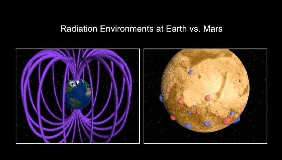
This is an artist concept comparing the present day magnetic fields on Earth and Mars. Earth magnetic field is generated by an active dynamo -- a hot core of molten metal.
NASA's Solar Dynamics Observatory (SDO) scientists use their computer models to generate a view of the sun's magnetic field (Aug. 10, 2018). We took the opportunity to compare an extreme ultraviolet view of the sun with the same image showing the superimposed field lines. The bright active region right at the central area of the sun clearly shows a concentration of field lines, as well as the small active region at the sun's right edge, but to a lesser extent. Magnetism drives the dynamic activity near the sun's surface. Movies are available at https://photojournal.jpl.nasa.gov/catalog/PIA22662
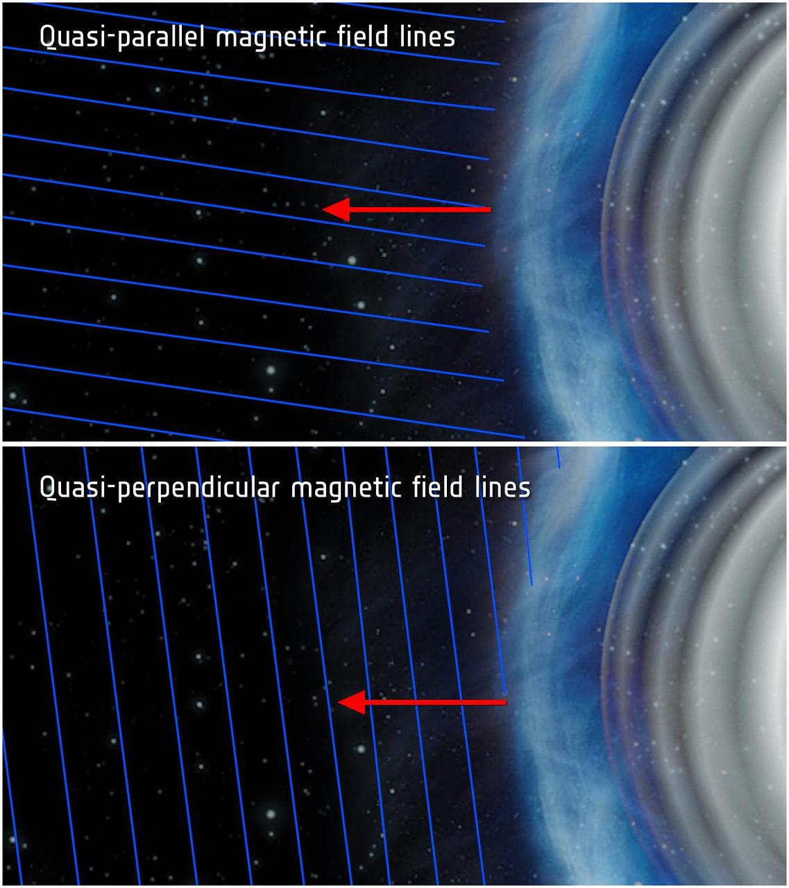
This illustration shows quasi-parallel top and quasi-perpendicular bottom magnetic field conditions at a planetary bow shock. Bow shocks are shockwaves created when the solar wind blows on a planet magnetic field.
This image shows part of the large dune field or erg that exists surrounding the north polar ice cap
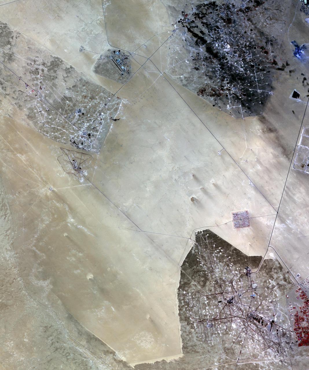
In the desert of southern Kuwait, three oil fields spread out across the empty landscape as seen by NASA Terra spacecraft.
This depiction of a simulated Mercury magnetosphere shows representations of the distortions of the planetary magnetic field lines blue by the solar wind.

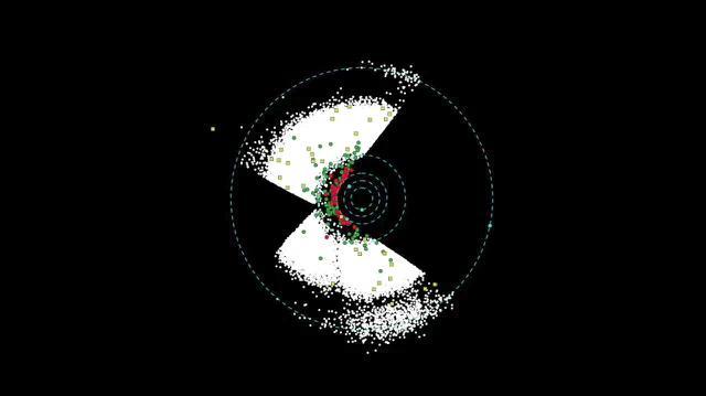
The Kepler space telescope examined twenty-one patches of the sky during it’s nine and a half years of operation. Within these regions, Kepler gathered high precision brightness measurements of over half a million stars facilitating the discovery of thousands of exoplanets and yielding insight into a multitude of other astrophysical phenomena. Illustration by Wendy Stenzel, Ames Science content: Jeff Coughlin, Kenneth Mighell, Doug Caldwell, all of NASA Ames.
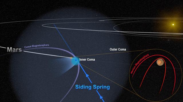
This artist depiction shows the close encounter between comet Siding Sprng and Mars in 2014. The comet powerful magnetic field temporarily merged with, and overwhelmed, the planet weak magnetic field.
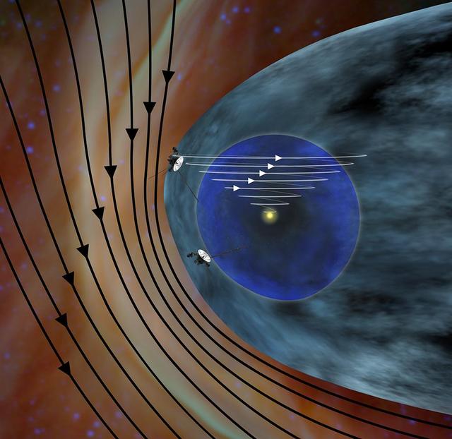
This artist concept shows the different expected directions of the magnetic fields in interstellar space black lines and the magnetic field emanating from our sun white lines as NASA Voyager 1 spacecraft travels northward out of the heliosphere.
This image shows asteroids observed so far by NASA Wide-field Infrared Survey Explorer. An animation is available at the Photojournal.
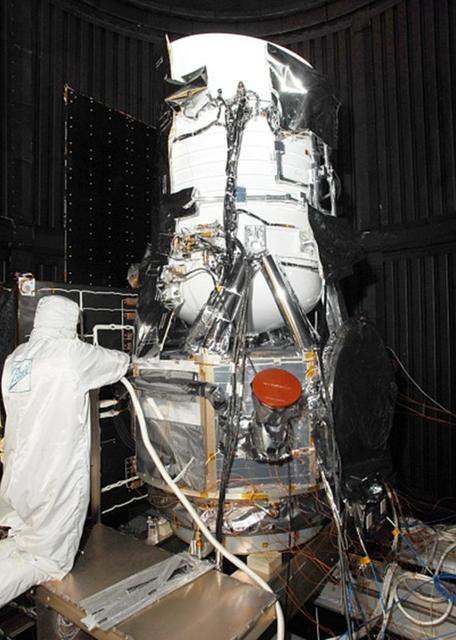
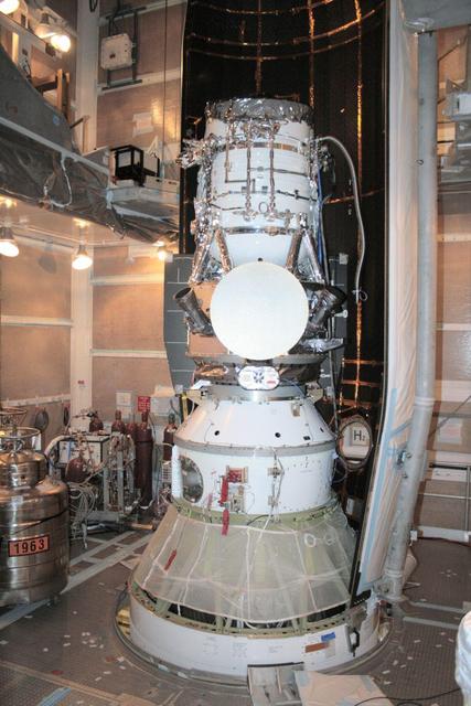
NASA Wide-field Infrared Survey Explorer in the clean room at Ball Aerospace & Technologies Corp., in Boulder, Colo.
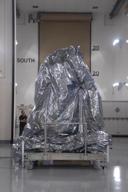
NASA Wide-field Infrared Survey Explorer spacecraft sits with its protective covering.
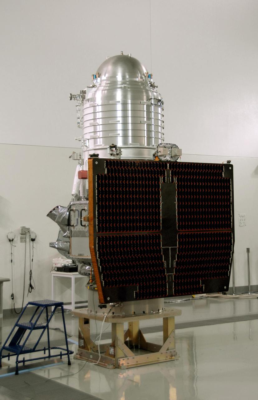
NASA Wide-field Infrared Survey Explorer, or WISE, spacecraft sits on the test stand after connection to the conical adapter.
NASA Wide-field Infrared Survey Explorer is shown inside one-half of the nose cone, or fairing, that will protect it during launch.

Seen as a red dusty cloud in this image from NASA Wide-field Infrared Survey Explorer, Puppis A is the remnant of a supernova explosion.
NASA Wide-field Infrared Survey Explorer is shown inside one-half of the nose cone, or fairing, that will protect it during launch.
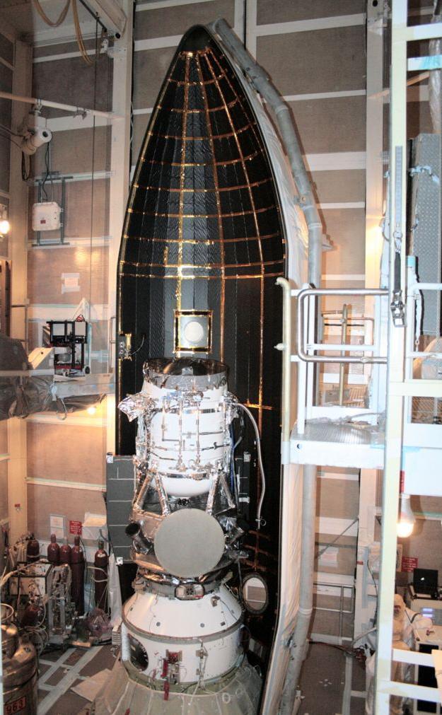
NASA Wide-field Infrared Survey Explorer is shown inside one-half of the nose cone, or fairing, that will protect it during launch.
NASA Wide-field Infrared Survey Explorer arrives at Vandenberg Air Force Base
A new infrared image from NASA Wide-field Infrared Survey Explorer shows a cosmic rosebud blossoming with new stars.
This artist concept shows NASA Wide-field Infrared Survey Explorer rotating in space, revealing all sides of the spacecraft.
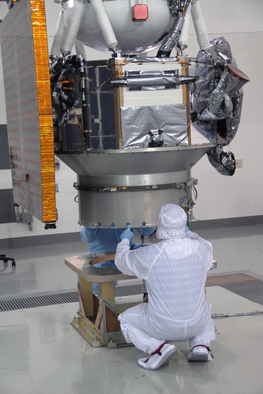
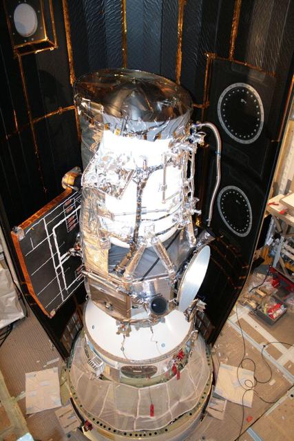
Workers check NASA Wide-field Infrared Survey Explorer, or WISE, spacecraft as it is lowered onto a work stand.
A star field in the constellation Cepheus is a composite of two 600-second exposures by the Framing Camera acquired during tests on December 3, 2007.

The Artemis II crew of Mission Specialist Jeremy Hansen from the CSA (Canadian Space Agency) and Mission Specialist Christina Koch, Pilot Victor Glover, and Commander Reid Wiseman from NASA are seen during a crew return event, Saturday, Apr. 11, 2026, at Ellington Field in Houston, Texas. NASA’s Artemis II test flight took Commander Reid Wiseman, Pilot Victor Glover, and Mission Specialist Christina Koch from NASA, and Mission Specialist Jeremy Hansen from the CSA (Canadian Space Agency) on an approximately nine-day mission around the Moon and back to Earth. Photo Credit: (NASA/John Kraus)

The Artemis II crew of Mission Specialist Jeremy Hansen from the CSA (Canadian Space Agency) and Mission Specialist Christina Koch, Pilot Victor Glover, and Commander Reid Wiseman from NASA are seen during a crew return event, Saturday, Apr. 11, 2026, at Ellington Field in Houston, Texas. NASA’s Artemis II test flight took Commander Reid Wiseman, Pilot Victor Glover, and Mission Specialist Christina Koch from NASA, and Mission Specialist Jeremy Hansen from the CSA (Canadian Space Agency) on an approximately nine-day mission around the Moon and back to Earth. Photo Credit: (NASA/John Kraus)
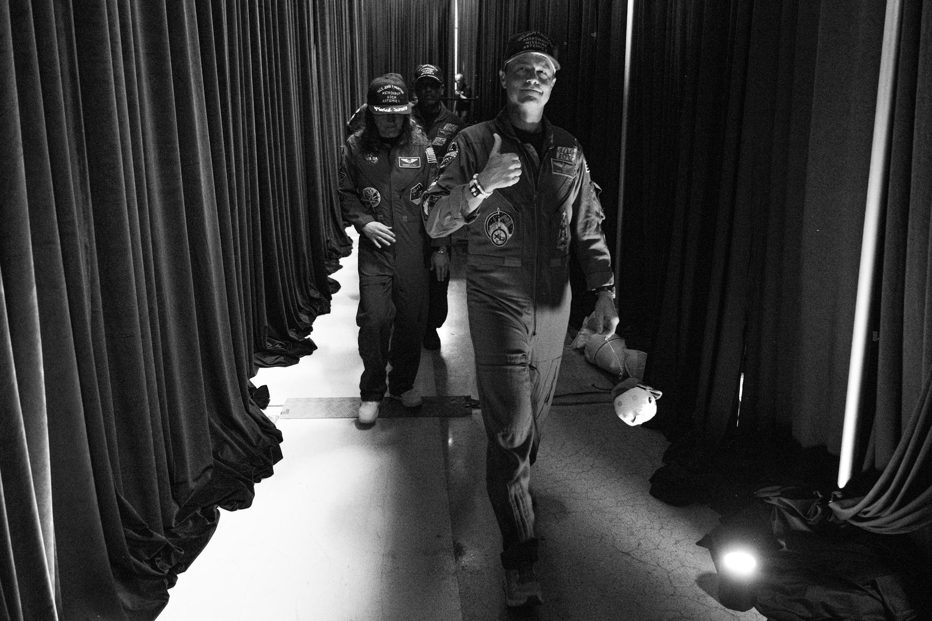
NASA astronaut Reid Wiseman, Artemis II commander, gives a thumbs up as the Artemis II crew arrives backstage during a crew return event, Saturday, Apr. 11, 2026, at Ellington Field in Houston, Texas. NASA’s Artemis II test flight took Commander Reid Wiseman, Pilot Victor Glover, and Mission Specialist Christina Koch from NASA, and Mission Specialist Jeremy Hansen from the CSA (Canadian Space Agency) on an approximately nine-day mission around the Moon and back to Earth. Photo Credit: (NASA/John Kraus)

The Artemis II crew of Mission Specialist Jeremy Hansen from the CSA (Canadian Space Agency) and Pilot Victor Glover, Mission Specialist Christina Koch, and Commander Reid Wiseman from NASA are seen backstage during a crew return event, Saturday, Apr. 11, 2026, at Ellington Field in Houston, Texas. NASA’s Artemis II test flight took Commander Reid Wiseman, Pilot Victor Glover, and Mission Specialist Christina Koch from NASA, and Mission Specialist Jeremy Hansen from the CSA (Canadian Space Agency) on an approximately nine-day mission around the Moon and back to Earth. Photo Credit: (NASA/John Kraus)
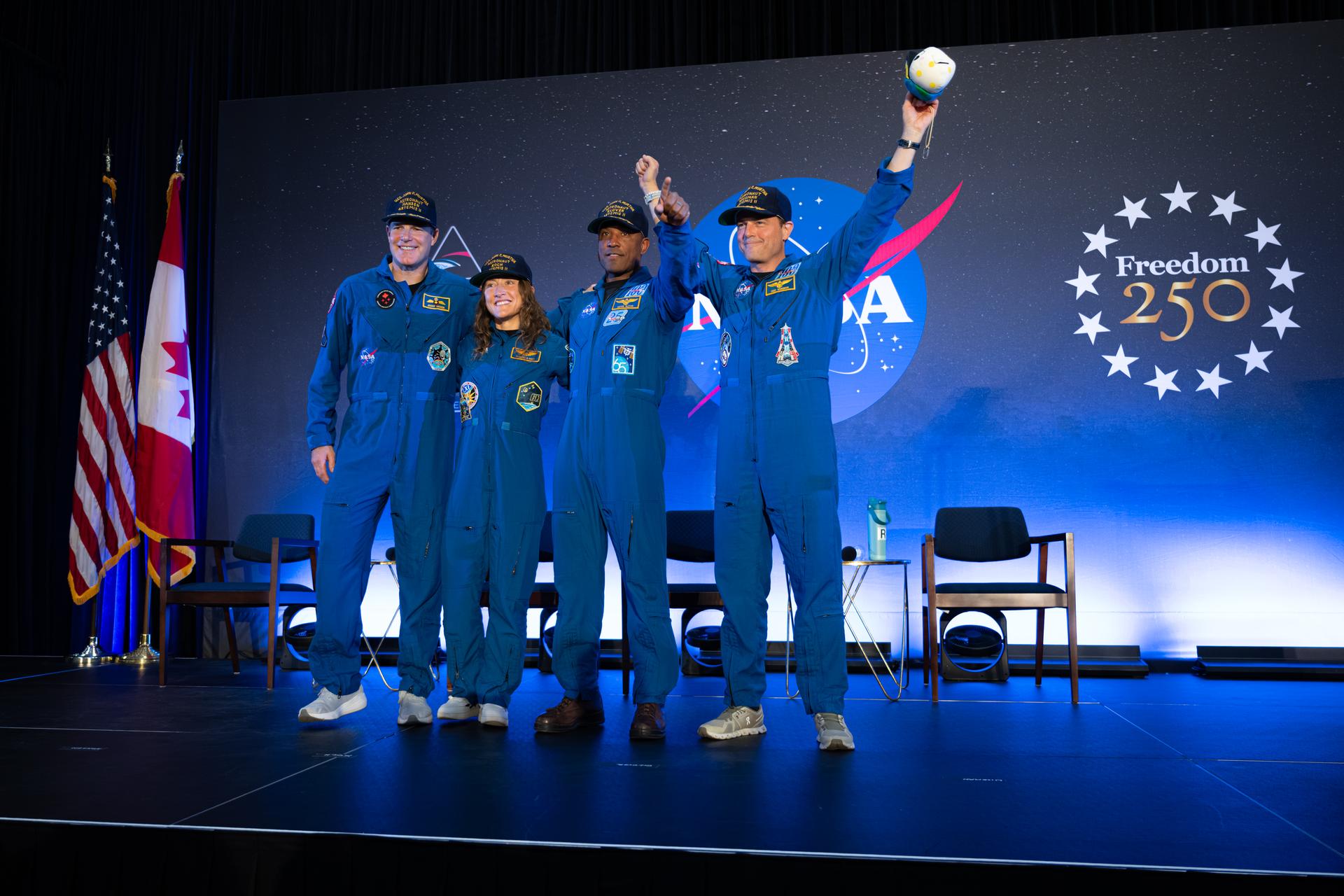
The Artemis II crew of Mission Specialist Jeremy Hansen from the CSA (Canadian Space Agency) and Mission Specialist Christina Koch, Pilot Victor Glover, and Commander Reid Wiseman from NASA are seen during a crew return event, Saturday, Apr. 11, 2026, at Ellington Field in Houston, Texas. NASA’s Artemis II test flight took Commander Reid Wiseman, Pilot Victor Glover, and Mission Specialist Christina Koch from NASA, and Mission Specialist Jeremy Hansen from the CSA (Canadian Space Agency) on an approximately nine-day mission around the Moon and back to Earth. Photo Credit: (NASA/John Kraus)
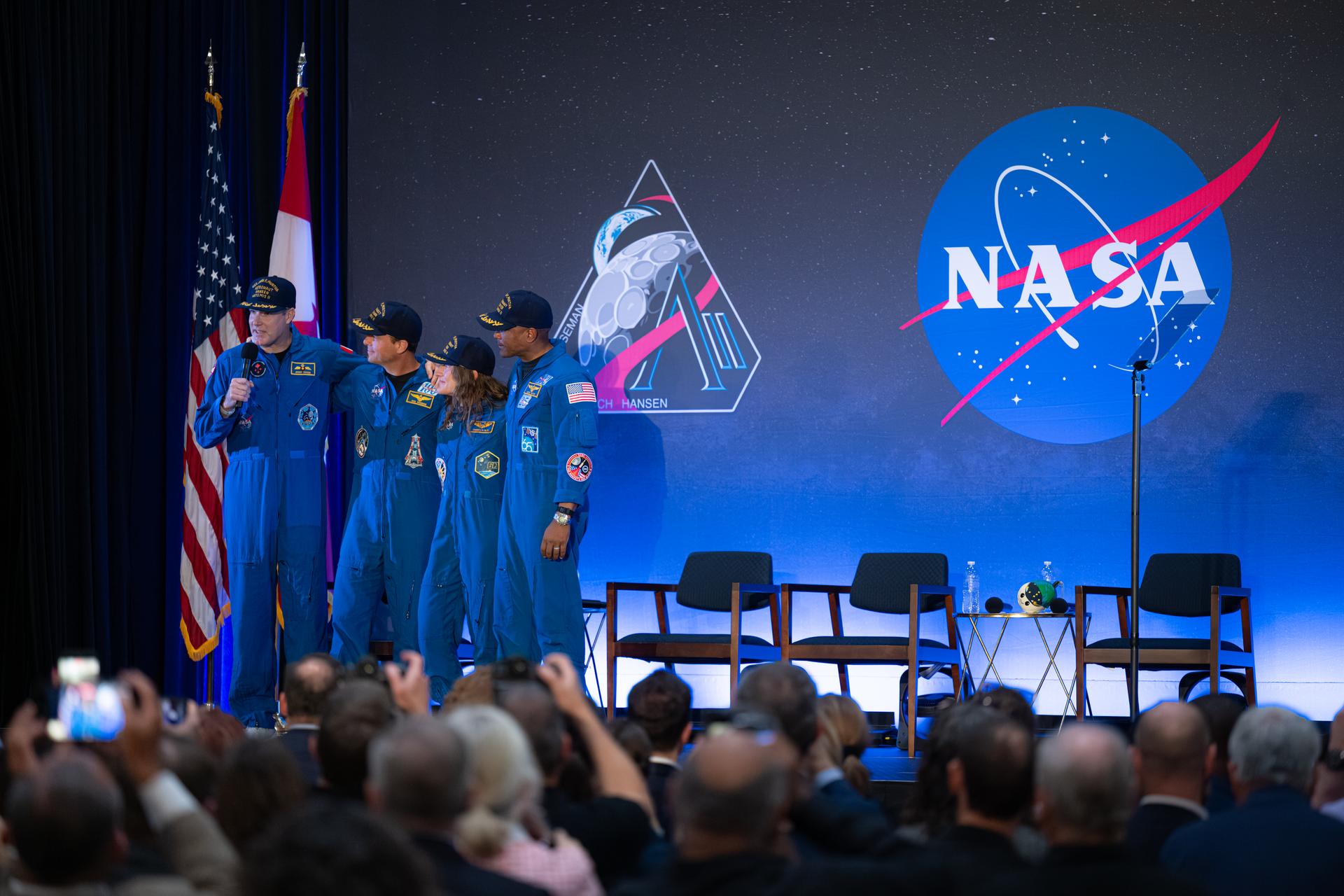
The Artemis II crew of Mission Specialist Jeremy Hansen from the CSA (Canadian Space Agency) and Commander Reid Wiseman, Mission Specialist Christina Koch, and Pilot Victor Glover from NASA are seen during a crew return event, Saturday, Apr. 11, 2026, at Ellington Field in Houston, Texas. NASA’s Artemis II test flight took Commander Reid Wiseman, Pilot Victor Glover, and Mission Specialist Christina Koch from NASA, and Mission Specialist Jeremy Hansen from the CSA (Canadian Space Agency) on an approximately nine-day mission around the Moon and back to Earth. Photo Credit: (NASA/John Kraus)

The Artemis II crew of Commander Reid Wiseman, Pilot Victor Glover, Mission Specialist Christina Koch from NASA and Mission Specialist Jeremy Hansen from the CSA (Canadian Space Agency) embrace during a crew return event, Saturday, Apr. 11, 2026, at Ellington Field in Houston, Texas. NASA’s Artemis II test flight took Commander Reid Wiseman, Pilot Victor Glover, and Mission Specialist Christina Koch from NASA, and Mission Specialist Jeremy Hansen from the CSA (Canadian Space Agency) on an approximately nine-day mission around the Moon and back to Earth. Photo Credit: (NASA/John Kraus)
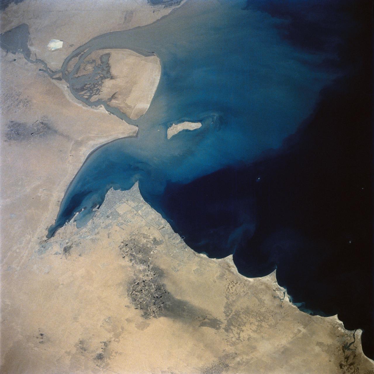
This view of the northern Persian Gulf shows Kuwait City and the Tigris and Euphrates River Deltas (29.5N, 48.5E). The oil laden sands and oil lakes of the Kuwait Oil Fields to the north and south of the city are clearly visible as dark patches surrounded by oil free desert sands. Comparison with earlier photos indicate that the oil laden sands are slowly being covered with clean sand carried by strong NW winds called Shmals.
This large mosaic image from NASA Wide-field Infrared Survey Explorer, features the wreckage of an exploded star, as well as other stars nearing the end of their lives.
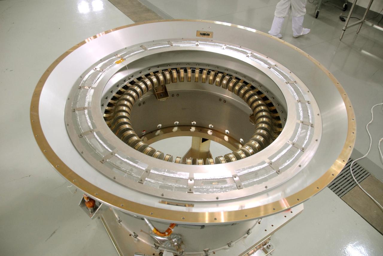
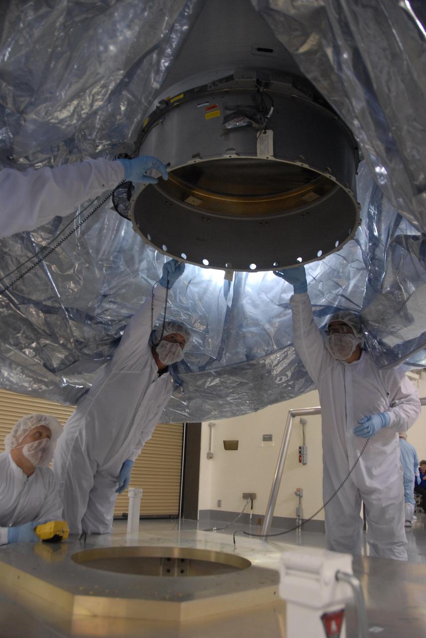
A view of the flexure springs in the soft ride being mated to the payload attach fitting for NASA Wide-field Infrared Survey Explorer, or WISE, spacecraft.
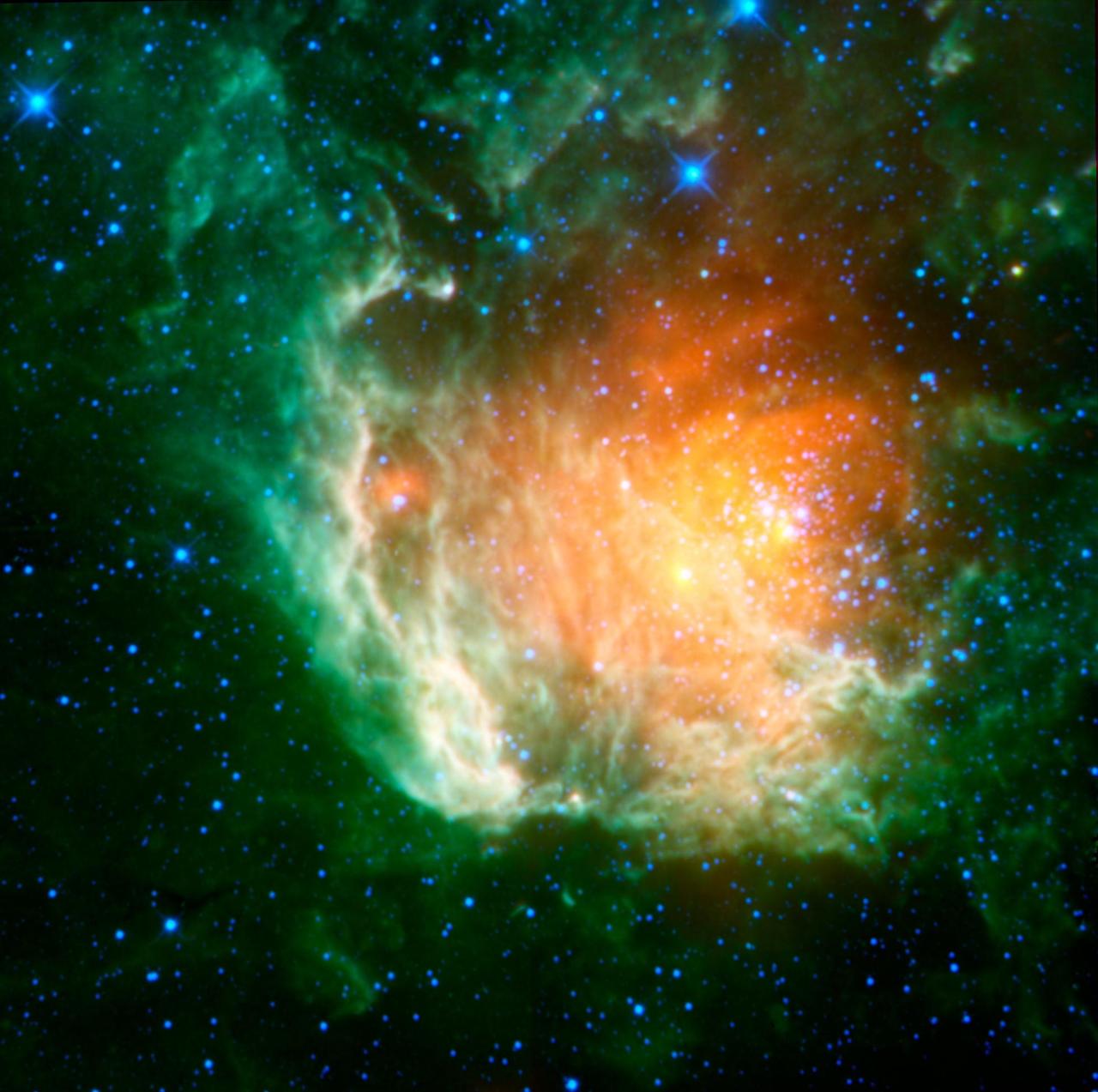
NASA Wide-Field Infrared Survey Explorer has uncovered a striking population of young stellar objects in a complex of dense, dark clouds in the southern constellation of Circinus.
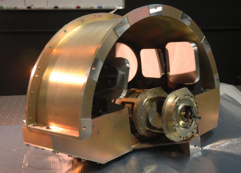
NASA Wide-field Infrared Survey Explorer, or WISE, back-end imager optics. This picture shows the imager optics which are mounted at the back of the optical system.
NASA Wide-field Infrared Survey Explorer, shows a giant nebula around Lambda Orionis, inflating Orion head to huge proportions.

NASA Wide-field Infrared Survey Explorer has seen a cluster of newborn stars enclosed in a cocoon of dust and gas in the constellation Camelopardalis.
An infrared portrait of the Witch Head nebula from NASA Wide-field Infrared Survey Explorer, or WISE, shows billowy clouds where new stars are brewing.

A new infrared image from NASA Wide-field Infrared Survey Explorer, or WISE, showcases the Tadpole nebula, and asteroids that just happened to be cruising by.
This infrared image taken by NASA Wide-field Infrared Survey Explorer shows a star-forming cloud teeming with gas, dust and massive newborn stars.
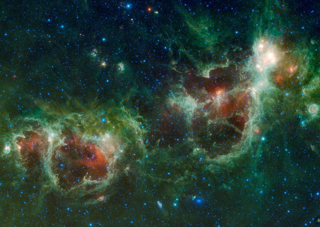
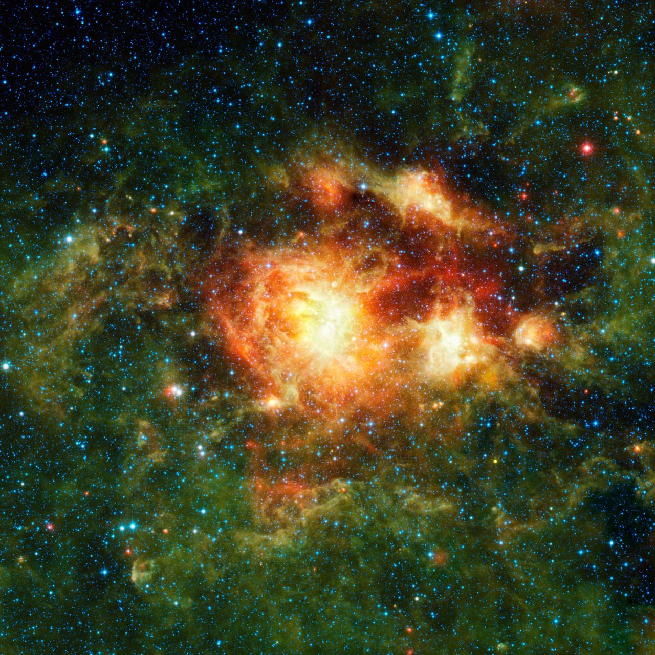
NASA Wide-field Infrared Survey Explorer has captured a huge mosaic of two bubbling clouds in space, known as the Heart and Soul nebulae.

The Seagull nebula, seen in this infrared mosaic from NASA Wide-field Infrared Survey Explorer, draws its common name from it resemblance to a gull in flight.

NASA Wide-field Infrared Survey Explorer, or WISE, helped lead astronomers to what appears to be a new example of a dancing black hole duo.
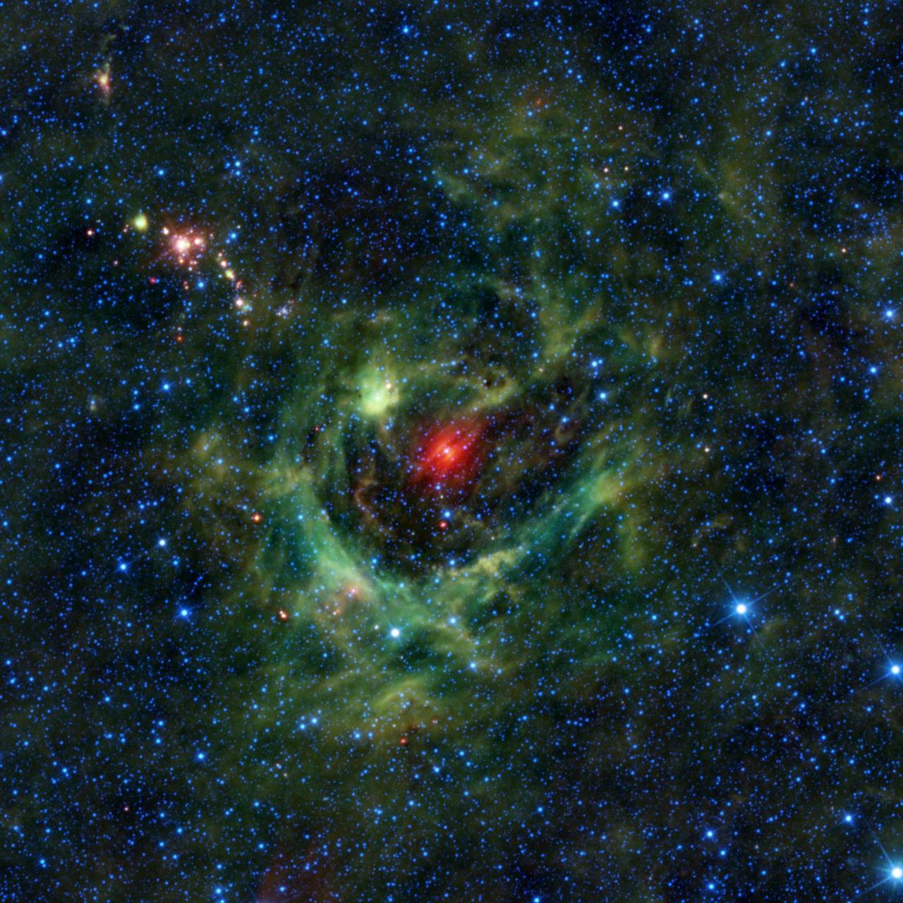
This image from NASA Wide-field Infrared Survey Explorer, or WISE, features a region of star birth wrapped in a blanket of dust, colored green in this infrared view.

This mosaic image from NASA Wide-field Infrared Survey Explorer is located in a constellation in the southern sky, Pavo, which is Latin for peacock.
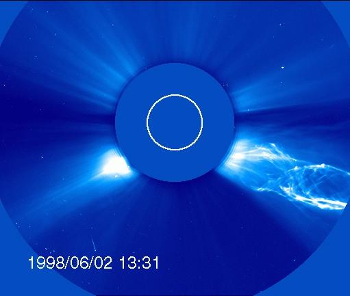
OHO captured this image of a CME from the side – but the structure looks much different from the classic light bulb CME. The filament of material bursting off the sun has a helical magnetic structure, which is unraveling like a piece of yarn during the eruption. Credit: ESA/NASA/SOHO..---..CME WEEK: What To See in CME Images Two main types of explosions occur on the sun: solar flares and coronal mass ejections. Unlike the energy and x-rays produced in a solar flare – which can reach Earth at the speed of light in eight minutes – coronal mass ejections are giant, expanding clouds of solar material that take one to three days to reach Earth. Once at Earth, these ejections, also called CMEs, can impact satellites in space or interfere with radio communications. During CME WEEK from Sept. 22 to 26, 2014, we explore different aspects of these giant eruptions that surge out from the star we live with. When a coronal mass ejection blasts off the sun, scientists rely on instruments called coronagraphs to track their progress. Coronagraphs block out the bright light of the sun, so that the much fainter material in the solar atmosphere -- including CMEs -- can be seen in the surrounding space. CMEs appear in these images as expanding shells of material from the sun's atmosphere -- sometimes a core of colder, solar material (called a filament) from near the sun's surface moves in the center. But mapping out such three-dimensional components from a two-dimensional image isn't easy. Watch the slideshow to find out how scientists interpret what they see in CME pictures. The images in the slideshow are from the three sets of coronagraphs NASA currently has in space. One is on the joint European Space Agency and NASA Solar and Heliospheric Observatory, or SOHO. SOHO launched in 1995, and sits between Earth and the sun about a million miles away from Earth. The other two coronagraphs are on the two spacecraft of the NASA Solar Terrestrial Relations Observatory, or STEREO, mission, which launched in 2006. The two STEREO spacecraft are both currently viewing the far side of the sun. Together these instruments help scientists create a three-dimensional model of any CME as its journey unfolds through interplanetary space. Such information can show why a given characteristic of a CME close to the sun might lead to a given effect near Earth, or any other planet in the solar system...<b><a href="http://www.nasa.gov/audience/formedia/features/MP_Photo_Guidelines.html" rel="nofollow">NASA image use policy.</a></b> <b><a href="http://www.nasa.gov/centers/goddard/home/index.html" rel="nofollow">NASA Goddard Space Flight Center</a></b> enables NASA’s mission through four scientific endeavors: Earth Science, Heliophysics, Solar System Exploration, and Astrophysics. Goddard plays a leading role in NASA’s accomplishments by contributing compelling scientific knowledge to advance the Agency’s mission. <b>Follow us on <a href="http://twitter.com/NASAGoddardPix" rel="nofollow">Twitter</a></b> <b>Like us on <a href="http://www.facebook.com/pages/Greenbelt-MD/NASA-Goddard/395013845897?ref=tsd" rel="nofollow">Facebook</a></b> <b>Find us on <a href="http://instagram.com/nasagoddard?vm=grid" rel="nofollow">Instagram</a></b>