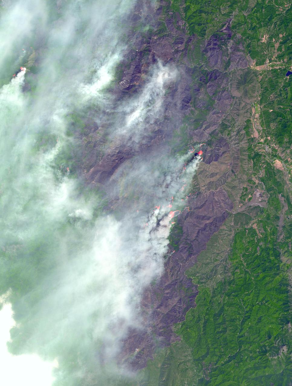
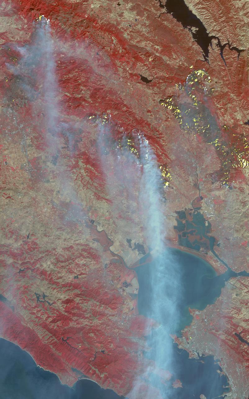
In southwest Oregon, the Biscuit Fire continues to grow. This image, acquired from the Advanced Spaceborne Thermal Emission and Reflection Radiometer (ASTER) on NASA's Terra satellite on August 14, 2002, shows the pillars of smoke arising from the fires. Active fire areas are in red. More than 6,000 fire personnel are assigned to the Biscuit Fire alone, which was 390,276 acres as of Thursday morning, August 15, and only 26 percent contained. Among the resources threatened are thousands of homes, three nationally designated wild and scenic rivers, and habitat for several categories of plants and animals at risk of extinction. Firefighters currently have no estimate as to when the fire might be contained. http://photojournal.jpl.nasa.gov/catalog/PIA03856
On November 18, 2003, the Advanced Spaceborne Thermal Emission and Reflection Radiometer (ASTER) on NASA's Terra satellite acquired this image of the Old Fire/Grand Prix fire east of Los Angeles. The image is being processed by NASA's Wildfire Response Team and will be sent to the United States Department of Agriculture's Forest Service Remote Sensing Applications Center (RSAC) which provides interpretation services to Burned Area Emergency Response (BAER) teams to assist in mapping the severity of the burned areas. The image combines data from the visible and infrared wavelength regions to highlight the burned areas. http://photojournal.jpl.nasa.gov/catalog/PIA04879
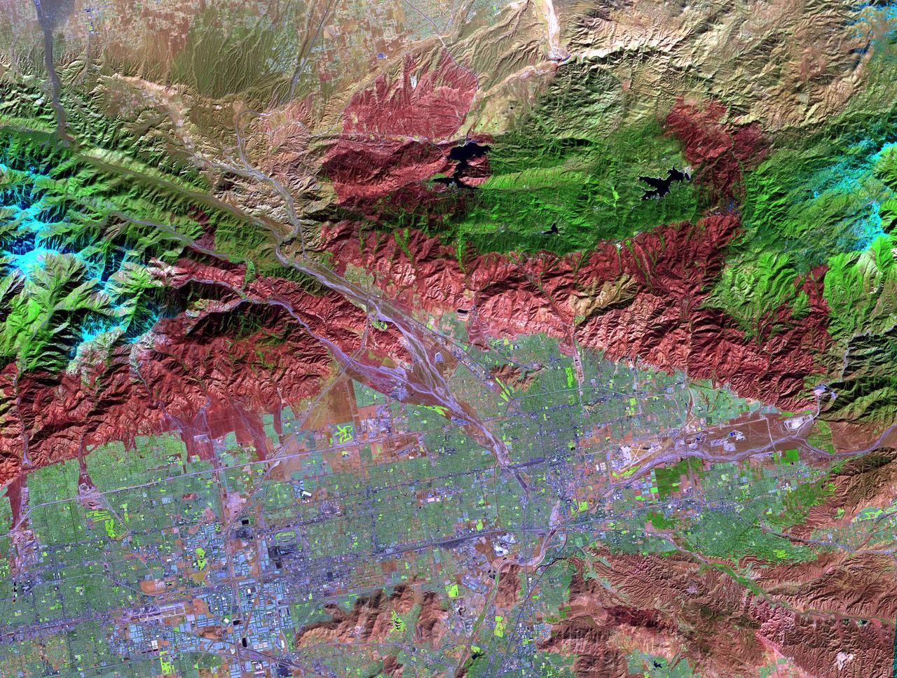
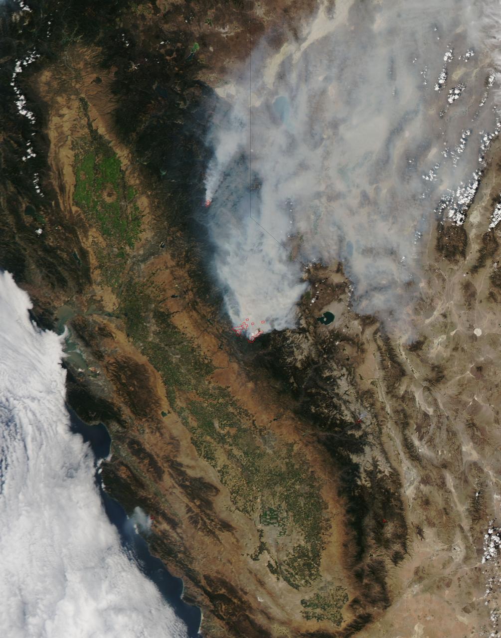
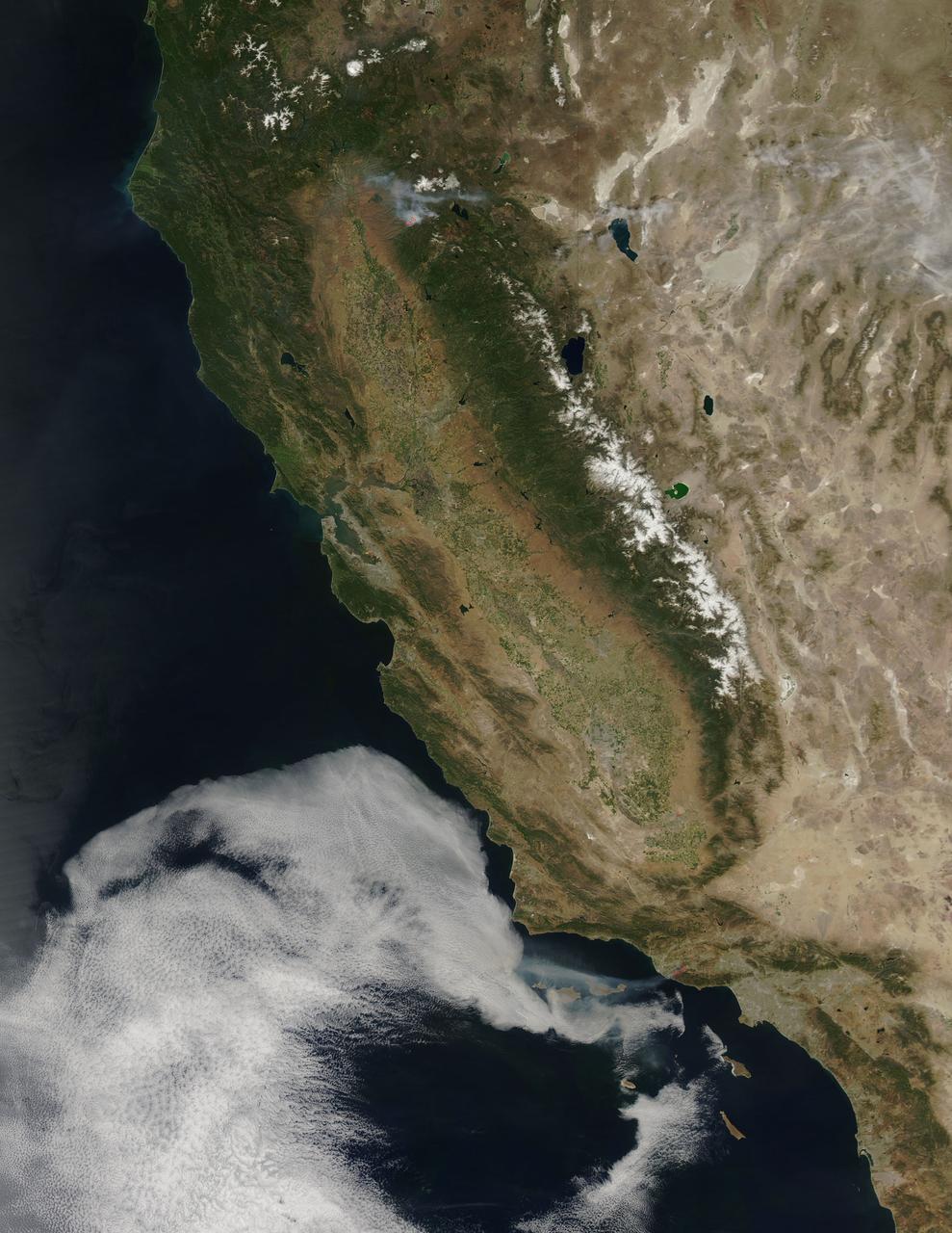
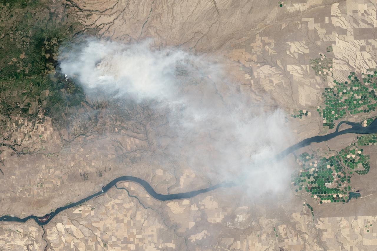
The October fires in Northern California were some of the most destructive in the state's history. The burned area on the right side of the image is the ATLAS fire, that burned east of Napa; the fire consumed 51,000 acres and destroyed almost 500 structures. The burned area on the left is part of the Nuns fire that burned between Sonoma and Napa; it consumed 110,000 acres, and destroyed almost 7,000 structures. The images were acquired September 7, 2016 and October 28, 2017, cover an area of 34.5 by 39 kilometers, and are located near 38.3 degrees north, 122.3 degrees east. https://photojournal.jpl.nasa.gov/catalog/PIA22019
After Fire
Broken Fire
Web of Fire
Frozen Fire
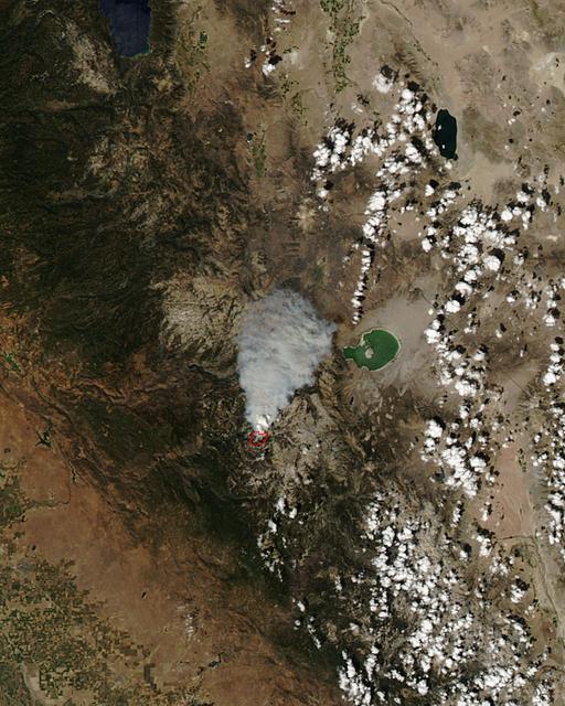
The Hayman forest fire, started on June 8, is continuing to burn in the Pike National Forest, 57 km (35 miles) south-southwest of Denver. According to the U.S. Forest Service, the fire has consumed more than 90,000 acres and has become Colorado's worst fire ever. In this ASTER image, acquired Sunday, June 16, 2002 at 10:30 am MST, the dark blue area is burned vegetation and the green areas are healthy vegetation. Red areas are active fires, and the blue cloud at the top center is smoke. Meteorological clouds are white. The image covers an area of 32.2 x 35.2 km (20.0 x 21.8 miles), and displays ASTER bands 8-3-2 in red, green and blue. http://photojournal.jpl.nasa.gov/catalog/PIA03499
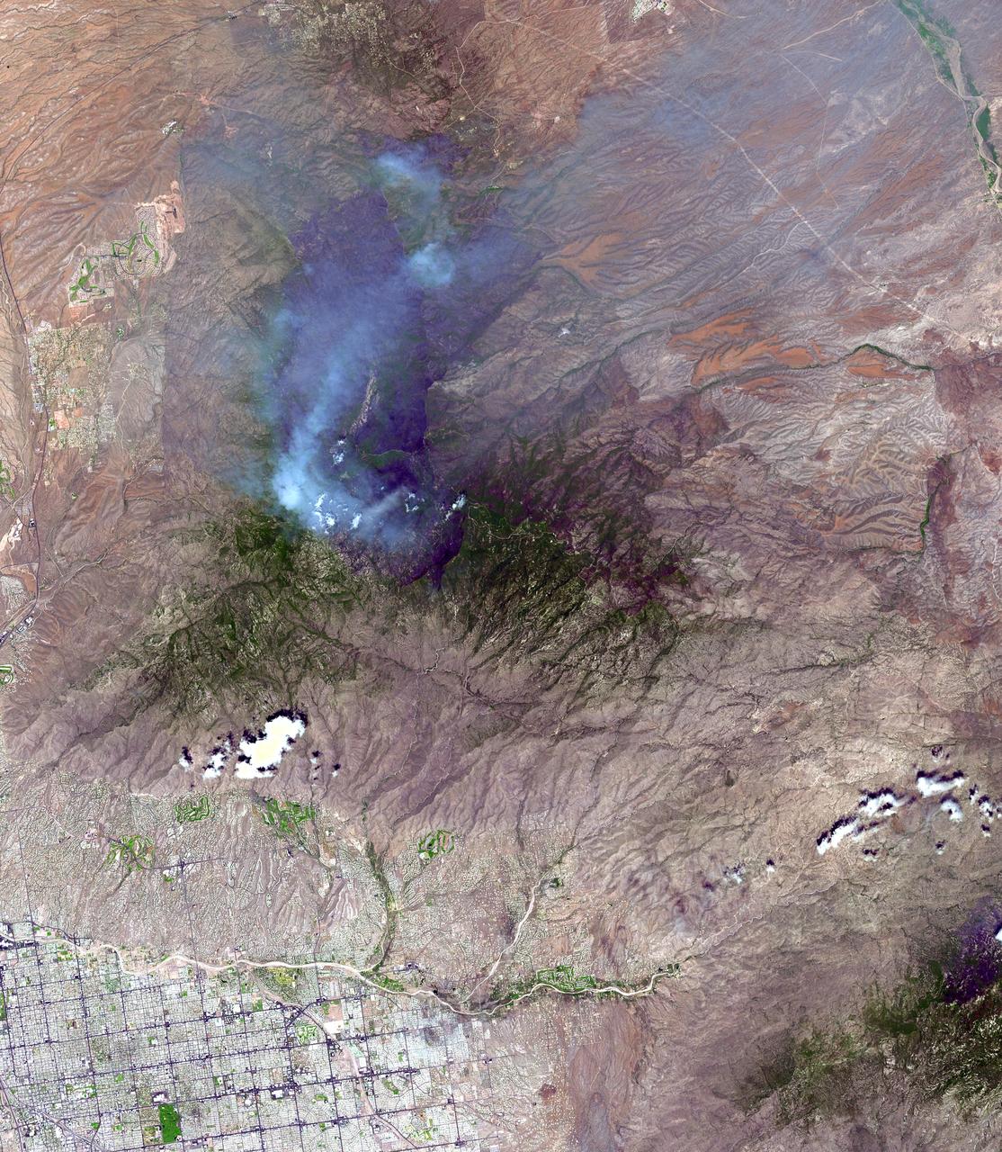
On June 26, NASA's Terra satellite acquired this image of the Aspen fire burning out of control north of Tucson, AZ. As of that date, the fire had consumed more than 27,000 acres and destroyed more than 300 homes, mostly in the resort community of Summerhaven, according to news reports. These data are being used by NASA's Wildfire Response Team and the US Forest Service to assess the intensity of the burn for future remediation efforts. This image was acquired on June 26, 2003 by the Advanced Spaceborne Thermal Emission and Reflection Radiometer (ASTER) on Terra. With its 14 spectral bands from the visible to the thermal infrared wavelength region, and its high spatial resolution of 15 to 90 meters (about 50 to 300 feet), ASTER images Earth to map and monitor the changing surface of our planet. http://photojournal.jpl.nasa.gov/catalog/PIA04602
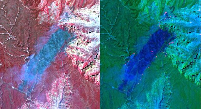
These ASTER images cover an area of 11 x 14 km on the north rim of the Grand Canyon, Arizona, and were acquired May 12, 2000. The left image displays bands 3,2,1 in RGB, displaying vegetation as red. The large dark area is burned forest, and small smoke plumes can be seen at the edges where active fires are burning. The right display substitutes SWIR band 8 for band 3. The bright red spots are the active fires, visible because the SWIR wavelength region has the capability to penetrate through the smoke. This image is located at 35.9 degrees north latitude and 113.4 degrees west longitude. http://photojournal.jpl.nasa.gov/catalog/PIA11092
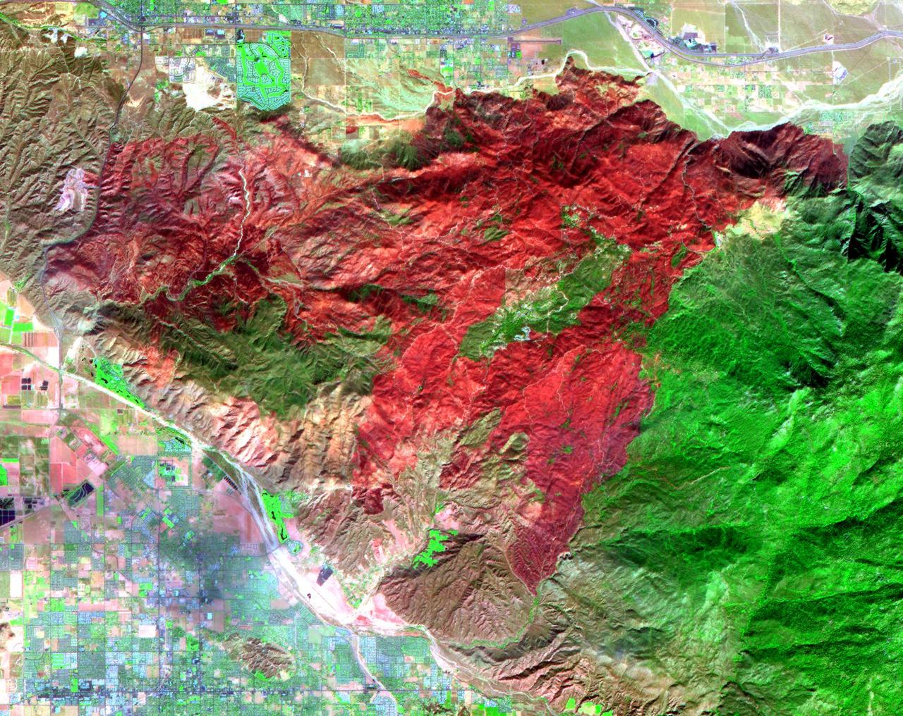
The Esperanza fire started on October 26 in the dry brush near Palm Springs, CA. By the time it was contained 6 days later, the fire had consumed 40,200 acres, and destroyed 34 homes and 20 outbuildings. Racing through grass, brush, and timber, the blaze had forced hundreds to evacuate, and it killed five firefighters who were working to protect homes. Fire officials are reporting the cause of the blaze as arson. In this ASTER image composite of visible and infrared bands, burned areas are shown in shades of red, vegetation is green, brown vegetation is brown and asphalt and concrete are blue-gray. http://photojournal.jpl.nasa.gov/catalog/PIA01900
This full-frame ASTER image, acquired August 30, 2000, covers an area of 60 by 60 km in the Salmon River Mountains, Idaho. In this color infrared composite, vegetation is red, clouds are white, and smoke from forest fires is blue. An enlargement (Figure 1) covers an area of 12 x 15 km. A thermal infrared band is displayed in red, a short wave infrared band is displayed in green, and a visible band is displayed in blue. In this combination, fires larger than about 50 m appear yellow because they are bright in both infrared bands. Smaller fires appear green because they are too small to be seen by the 90 m thermal pixels, but large enough to be detected in the 30 m short wave infrared pixels. We are able to see through the smoke in the infrared bands, whereas in the visible bands, the smoke obscures detection of the active fires. This image is located at 44.8 degrees north latitude and 114.8 degrees west longitude. http://photojournal.jpl.nasa.gov/catalog/PIA11088
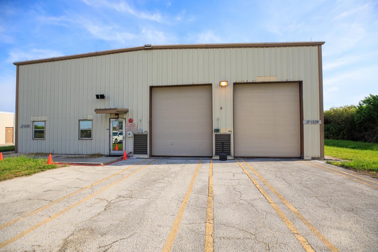
An exterior view of Fire Station 3 at Launch Complex 39B at NASA’s Kennedy Space Center in Florida on Sept. 8, 2022.
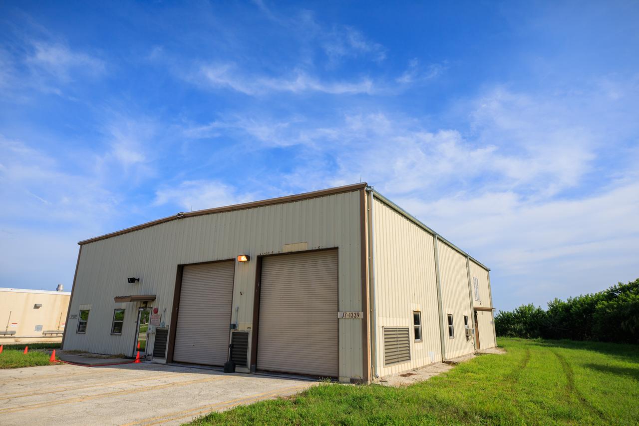
An exterior view of Fire Station 3 at Launch Complex 39B at NASA’s Kennedy Space Center in Florida on Sept. 8, 2022.
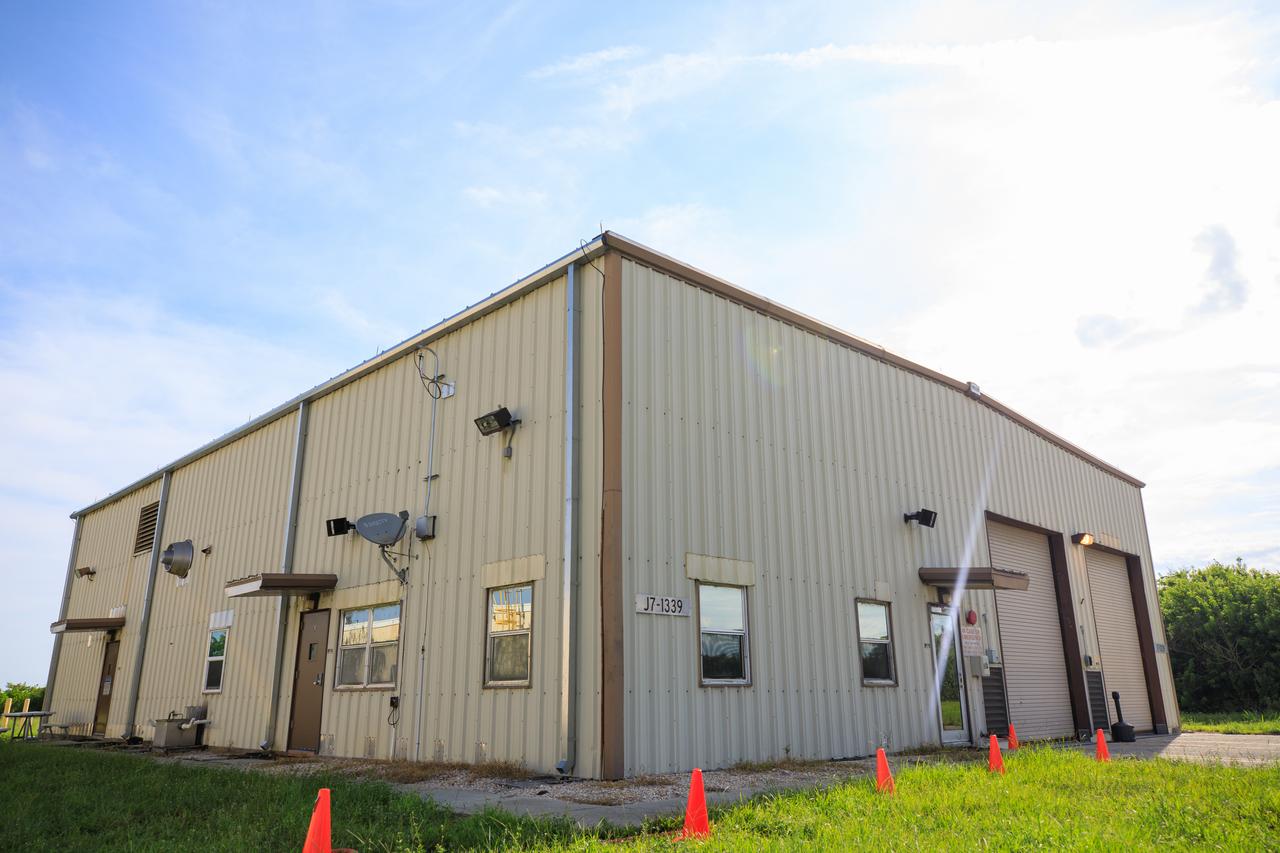
An exterior view of Fire Station 3 at Launch Complex 39B at NASA’s Kennedy Space Center in Florida on Sept. 8, 2022.
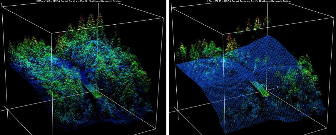
New maps of two recent California megafires that combine unique data sets from the U.S. Forest Service and NASA's Jet Propulsion Laboratory in Pasadena, California, are answering some of the urgent questions that follow a huge wildfire. These before-and-after USFS LIght Detection And Ranging (LIDAR) images from the 2014 King fire region in El Dorado National Forest, California are among new maps. They show a small section of the Rubicon River drainage basin, where fire damage was severe. Blue indicates ground level; lighter colors are higher. A road -- bordered by dense trees in the before image at left -- and part of a bridge are in the center, with the bridge appearing green. http://photojournal.jpl.nasa.gov/catalog/PIA19360
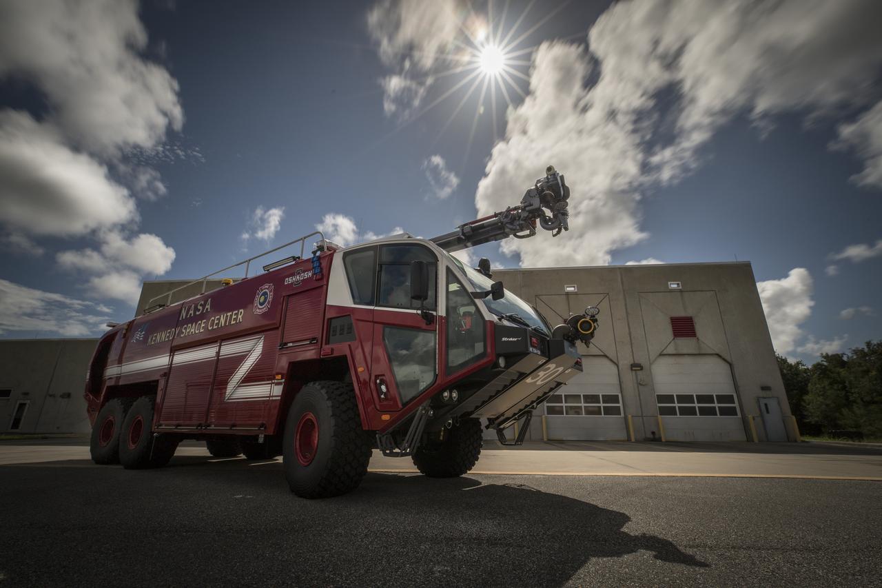
A new Aircraft Rescue and Fire Fighting vehicle is photographed in front of Fire Station No. 2 near the Shuttle Landing Facility runway at NASA’s Kennedy Space Center in Florida. The state-of-the-art truck replaces a 28-year-old vehicle. Kennedy is upgrading its fleet of emergency vehicles to enhance its safety and security posture at the growing, multi-user spaceport.
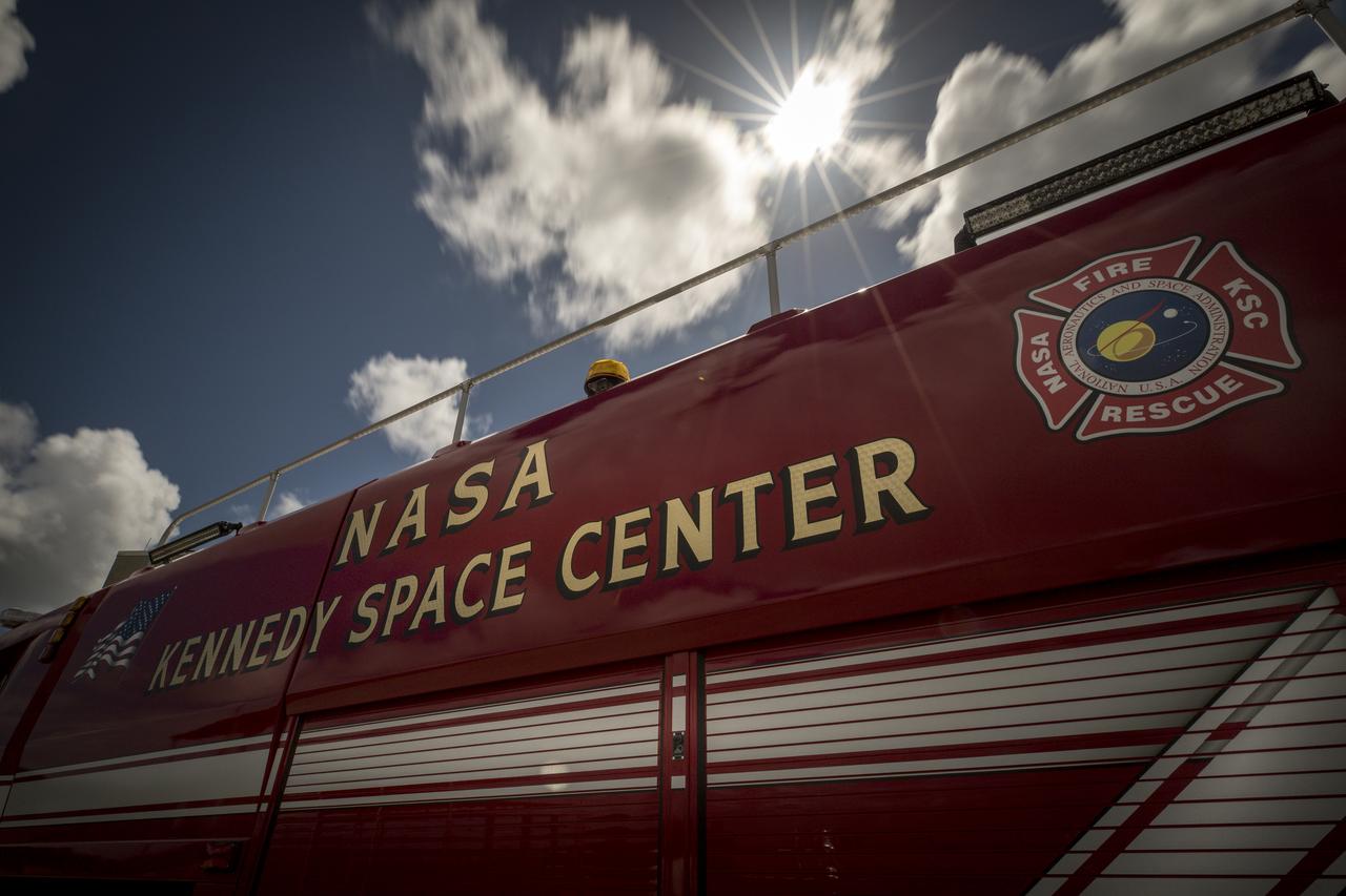
A new Aircraft Rescue and Fire Fighting vehicle is photographed in front of Fire Station No. 2 near the Shuttle Landing Facility runway at NASA’s Kennedy Space Center in Florida. The state-of-the-art truck replaces a 28-year-old vehicle. Kennedy is upgrading its fleet of emergency vehicles to enhance its safety and security posture at the growing, multi-user spaceport.
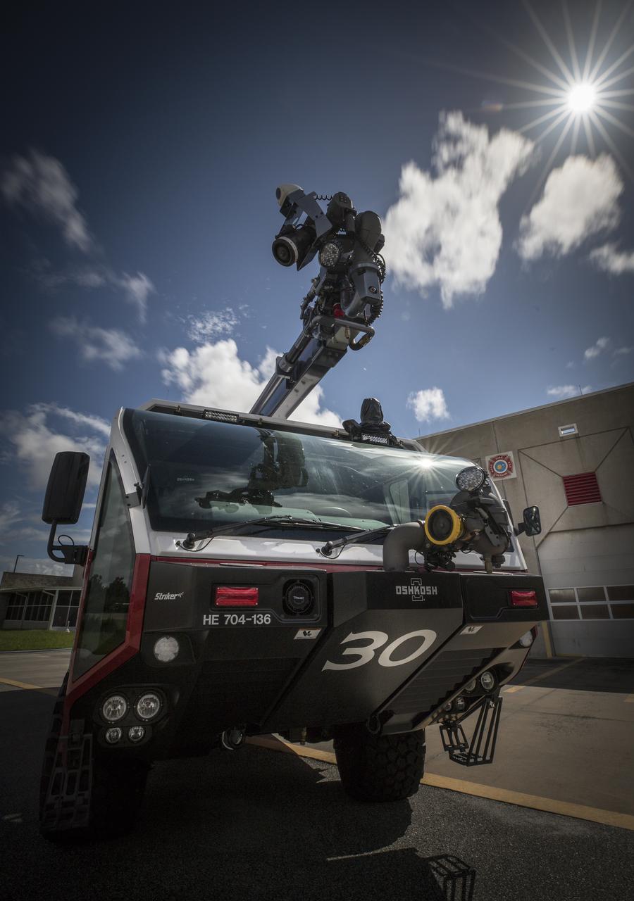
A new Aircraft Rescue and Fire Fighting vehicle is photographed in front of Fire Station No. 2 near the Shuttle Landing Facility runway at NASA’s Kennedy Space Center in Florida. The state-of-the-art truck replaces a 28-year-old vehicle. Kennedy is upgrading its fleet of emergency vehicles to enhance its safety and security posture at the growing, multi-user spaceport.
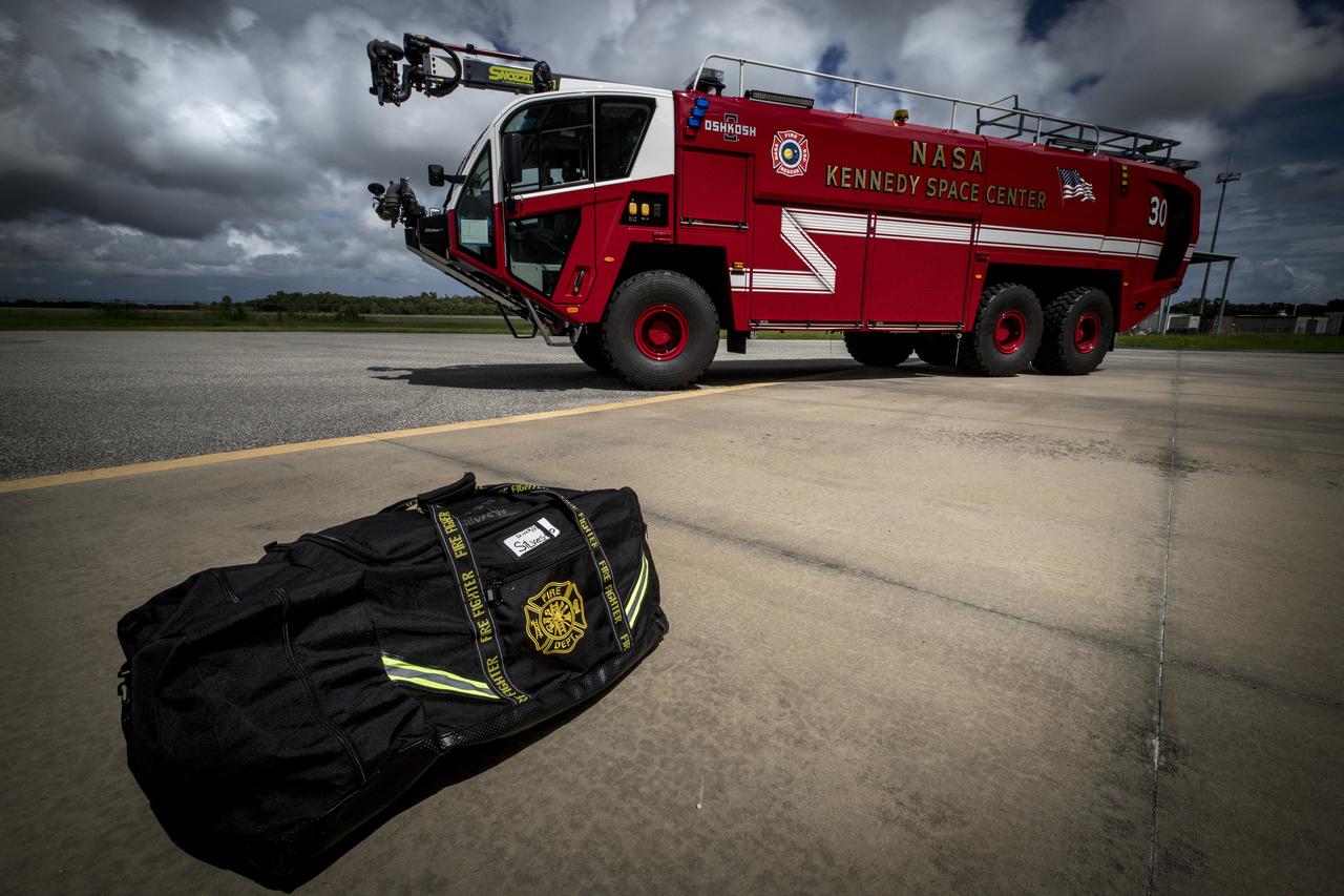
A new Aircraft Rescue and Fire Fighting vehicle is photographed in front of Fire Station No. 2 near the Shuttle Landing Facility runway at NASA’s Kennedy Space Center in Florida. The state-of-the-art truck replaces a 28-year-old vehicle. Kennedy is upgrading its fleet of emergency vehicles to enhance its safety and security posture at the growing, multi-user spaceport.
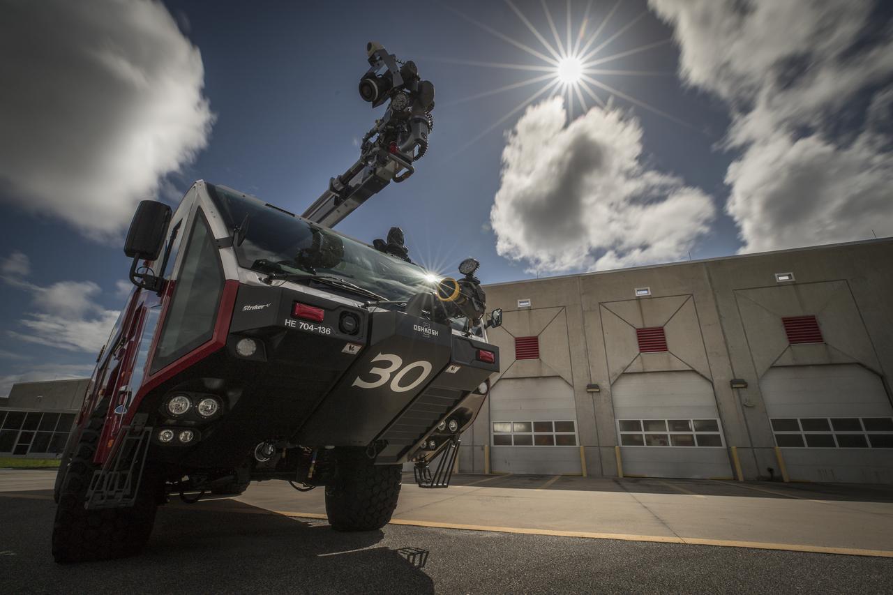
A new Aircraft Rescue and Fire Fighting vehicle is photographed in front of Fire Station No. 2 near the Shuttle Landing Facility runway at NASA’s Kennedy Space Center in Florida. The state-of-the-art truck replaces a 28-year-old vehicle. Kennedy is upgrading its fleet of emergency vehicles to enhance its safety and security posture at the growing, multi-user spaceport.
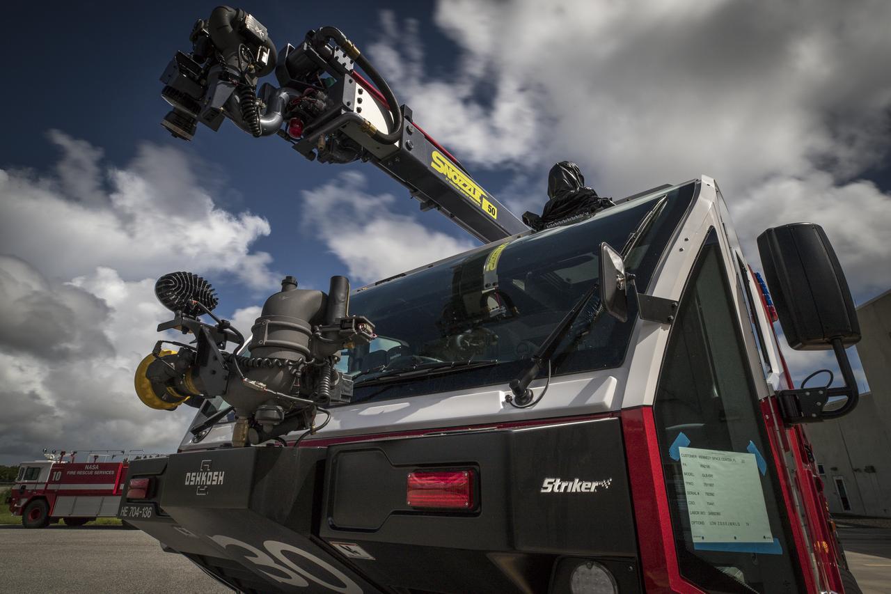
A new Aircraft Rescue and Fire Fighting vehicle is photographed in front of Fire Station No. 2 near the Shuttle Landing Facility runway at NASA’s Kennedy Space Center in Florida. The state-of-the-art truck replaces a 28-year-old vehicle. Kennedy is upgrading its fleet of emergency vehicles to enhance its safety and security posture at the growing, multi-user spaceport.
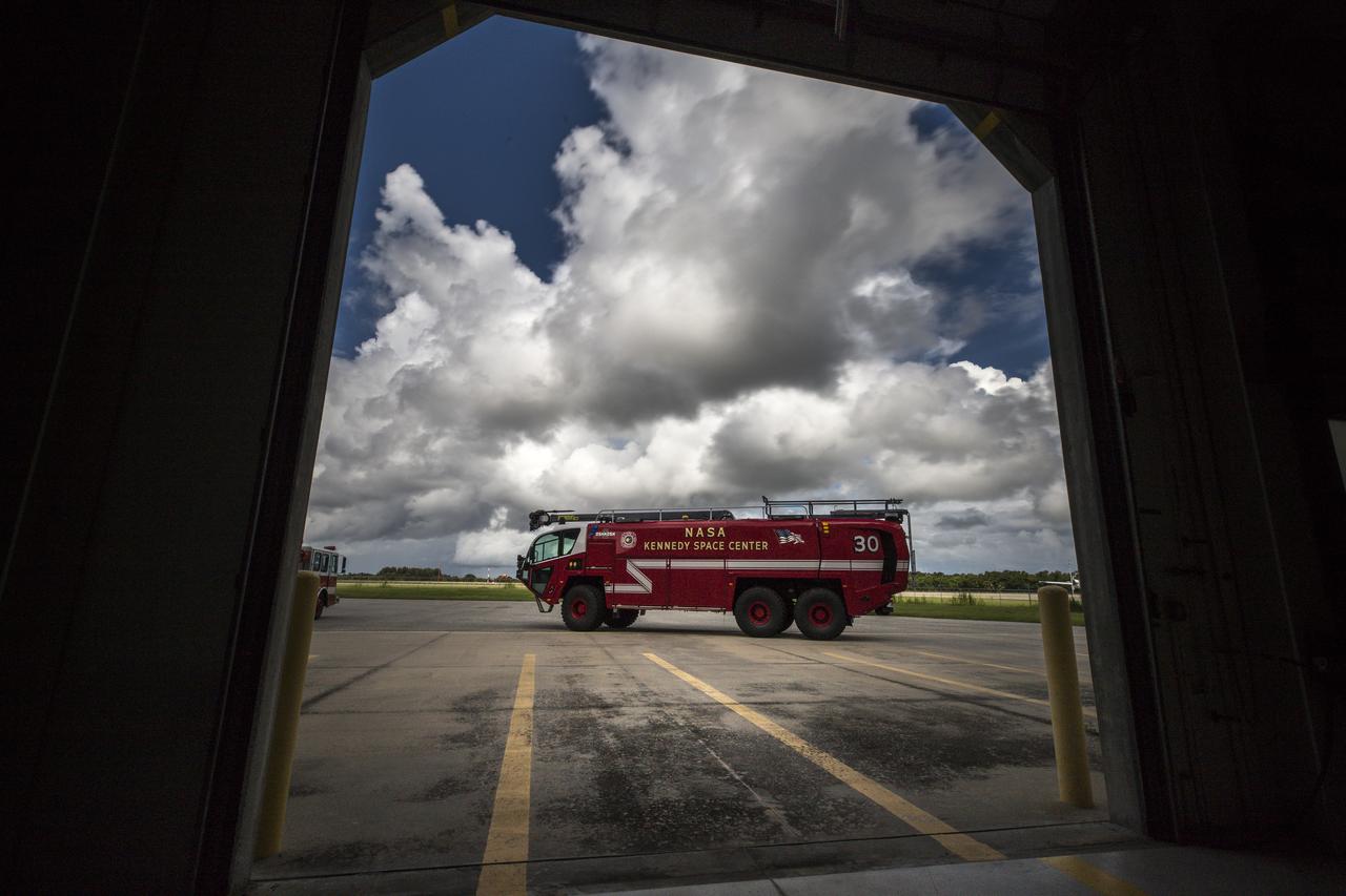
A new Aircraft Rescue and Fire Fighting vehicle is photographed through the open door of Fire Station No. 2 near the Shuttle Landing Facility runway at NASA’s Kennedy Space Center in Florida. The state-of-the-art truck replaces a 28-year-old vehicle. Kennedy is upgrading its fleet of emergency vehicles to enhance its safety and security posture at the growing, multi-user spaceport.
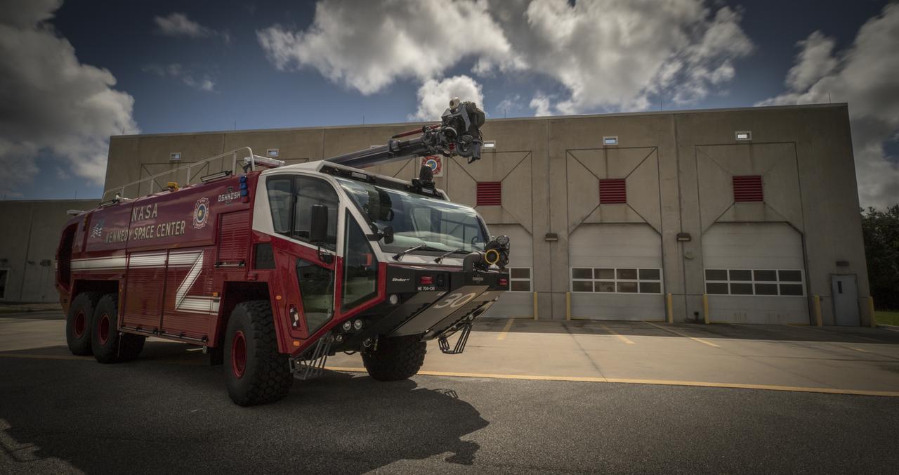
A new Aircraft Rescue and Fire Fighting vehicle is photographed in front of Fire Station No. 2 near the Shuttle Landing Facility runway at NASA’s Kennedy Space Center in Florida. The state-of-the-art truck replaces a 28-year-old vehicle. Kennedy is upgrading its fleet of emergency vehicles to enhance its safety and security posture at the growing, multi-user spaceport.
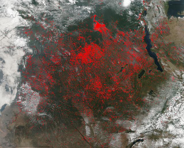
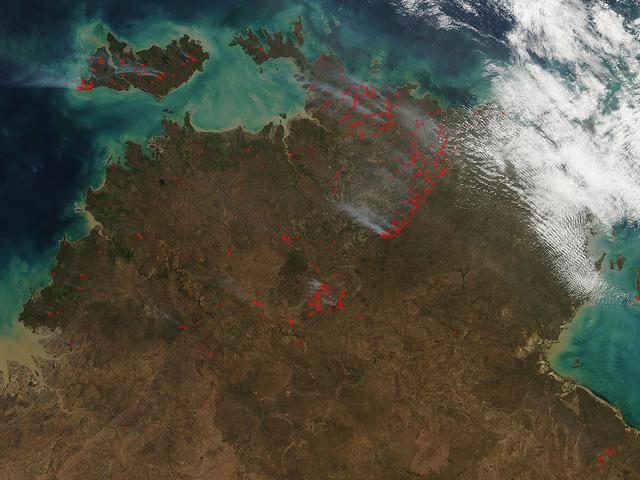
The Suomi NPP satellite's Visible Infrared Imaging Radiometer Suite (VIIRS) instrument captured a look at huge numbers of fires burning and the resulting smoke in central Africa on June 27, 2017. Actively burning areas, detected by VIIRS are outlined in red. The fires obscure most of the landscape in central Africa. June heralds the end of the crop season in this part of the world, and these fires may be intentional agricultural fires set by people to rid the area of left over crops and get it ready for the next season. So too some of these may also be lightning strike fires or they may be accidental fires which may have gotten out of control. The Suomi NPP satellite is a joint mission between NASA and NOAA. NASA image courtesy Jeff Schmaltz, MODIS Rapid Response Team <b><a href="http://www.nasa.gov/audience/formedia/features/MP_Photo_Guidelines.html" rel="nofollow">NASA image use policy.</a></b> <b><a href="http://www.nasa.gov/centers/goddard/home/index.html" rel="nofollow">NASA Goddard Space Flight Center</a></b> enables NASA’s mission through four scientific endeavors: Earth Science, Heliophysics, Solar System Exploration, and Astrophysics. Goddard plays a leading role in NASA’s accomplishments by contributing compelling scientific knowledge to advance the Agency’s mission. <b>Follow us on <a href="http://twitter.com/NASAGoddardPix" rel="nofollow">Twitter</a></b> <b>Like us on <a href="http://www.facebook.com/pages/Greenbelt-MD/NASA-Goddard/395013845897?ref=tsd" rel="nofollow">Facebook</a></b> <b>Find us on <a href="http://instagrid.me/nasagoddard/?vm=grid" rel="nofollow">Instagram</a></b>
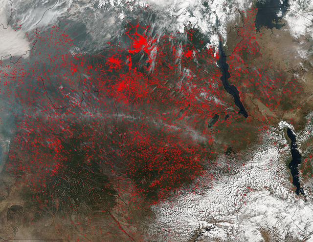
NASA’s Suomi NPP satellite detected thousands of fires burning in central Africa on July 11, 2016. The fires are represented by the multitudes of red dots. Most of the fires burn in grass or cropland. The location, widespread nature, and number of fires suggest that these fires were deliberately set to manage land. Places where traditional plots of open land is not available because the vegetation in the area is dense are the places where "slash and burn" agriculture is practiced most often. These regions include parts of Africa, northern South America, and Southeast Asia, where an abundance of grasslands and rainforests are found. Although most parts of the world outlaw this type of agriculture due to the fact that the smoke from these (or any) fires is a health hazard, the method of agriculture continues because it is the easiest and lowest cost solution to clearing fields for next year's crops. The Suomi NPP satellite is a joint mission between NASA, NOAA and the U.S. Department of Defense. NASA image courtesy Jeff Schmaltz, MODIS Rapid Response Team.
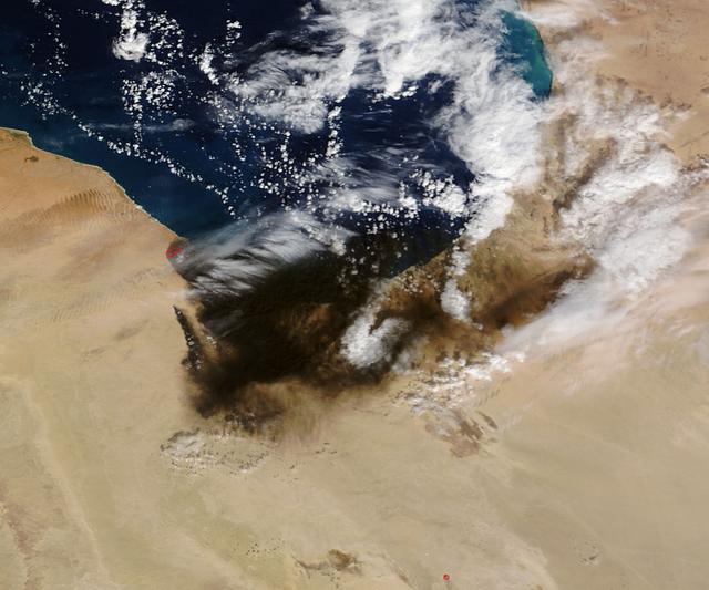
The oil refinery fires in Libya that were started by attacks on oil terminals in Libya in very early January continue. The stream of black smoke that emanates from the refinery has grown tremendously as the fires caused by the initial shelling have spread to giant storage tanks. These fires are reported to be raging in Sidra, on the coast between Sirte and Benghazi. Actively burning areas, detected by MODIS’s thermal bands, are outlined in red. The initial image of the fires taken on January 07, 2016 can be found here for comparison: <a href="http://www.nasa.gov/image-feature/goddard/2016/terra-captures-images-of-oil-fires-in-libya" rel="nofollow">www.nasa.gov/image-feature/goddard/2016/terra-captures-im...</a> NASA image courtesy Jeff Schmaltz, MODIS Rapid Response Team <b><a href="http://www.nasa.gov/audience/formedia/features/MP_Photo_Guidelines.html" rel="nofollow">NASA image use policy.</a></b> <b><a href="http://www.nasa.gov/centers/goddard/home/index.html" rel="nofollow">NASA Goddard Space Flight Center</a></b> enables NASA’s mission through four scientific endeavors: Earth Science, Heliophysics, Solar System Exploration, and Astrophysics. Goddard plays a leading role in NASA’s accomplishments by contributing compelling scientific knowledge to advance the Agency’s mission. <b>Follow us on <a href="http://twitter.com/NASAGoddardPix" rel="nofollow">Twitter</a></b> <b>Like us on <a href="http://www.facebook.com/pages/Greenbelt-MD/NASA-Goddard/395013845897?ref=tsd" rel="nofollow">Facebook</a></b> <b>Find us on <a href="http://instagrid.me/nasagoddard/?vm=grid" rel="nofollow">Instagram</a></b>
The single fire that ignited and split into nine separate fires still blazes in Southern California today. Firefighters are hoping for a break today (Thursday, May 15, 2014) but it doesn't look like luck may be on their side. Conditions continue to be bone dry with unseasonal heat (98-106 degrees) and the Santa Ana winds are kicking up and allowing these fires to easy jump fire lines. This particular fire started on Wednesday as a single fire and within a day is now nine separate fires which have burned close to 10,000 acres. These fires are threatening more than just landscape in San Diego county, they are also threatening homes, universities, a military base and a nuclear power plant. Day Two of the fires have seen them already destroying dozens of homes and forcing tens of thousands to evacuate. Camp Pendleton has also been partially evacuated due to the blazes as has the popular amusement park, Legoland. The Governor of California has declared a state of emergency. Thousands of firefighters are battling the flames both on the ground and in the air. Seven tankers and 20 military aircraft are also assisting the firefighters with their mission. Temperatures soaring over 100 degrees coupled with 30 mph wind gusts have severely hampered the efforts, however, and fire tornadoes have broken out. Fire tornadoes are caused by crosswinds that create a vortex and produce winds that twist and swirl just like a tornado but with flames that coil upwards in the center of the twister creating a terrifying specter. Although there is no chance of rain in the area for the next several days, the temperatures will start to subside on Friday and into the weekend. Winds are also expected to start to subside, giving firefighters that break that they so desperately need. This natural-color satellite image was collected by the Moderate Resolution Imaging Spectroradiometer (MODIS) aboard the Aqua satellite on May 14, 2014. Actively burning areas, detected by MODIS’s thermal bands, are outlined in red. Credit: NASA/GSFC/Jeff Schmaltz/MODIS Land Rapid Response Team <b><a href="http://www.nasa.gov/audience/formedia/features/MP_Photo_Guidelines.html" rel="nofollow">NASA image use policy.</a></b> <b><a href="http://www.nasa.gov/centers/goddard/home/index.html" rel="nofollow">NASA Goddard Space Flight Center</a></b> enables NASA’s mission through four scientific endeavors: Earth Science, Heliophysics, Solar System Exploration, and Astrophysics. Goddard plays a leading role in NASA’s accomplishments by contributing compelling scientific knowledge to advance the Agency’s mission. <b>Follow us on <a href="http://twitter.com/NASAGoddardPix" rel="nofollow">Twitter</a></b> <b>Like us on <a href="http://www.facebook.com/pages/Greenbelt-MD/NASA-Goddard/395013845897?ref=tsd" rel="nofollow">Facebook</a></b> <b>Find us on <a href="http://instagram.com/nasagoddard?vm=grid" rel="nofollow">Instagram</a></b>
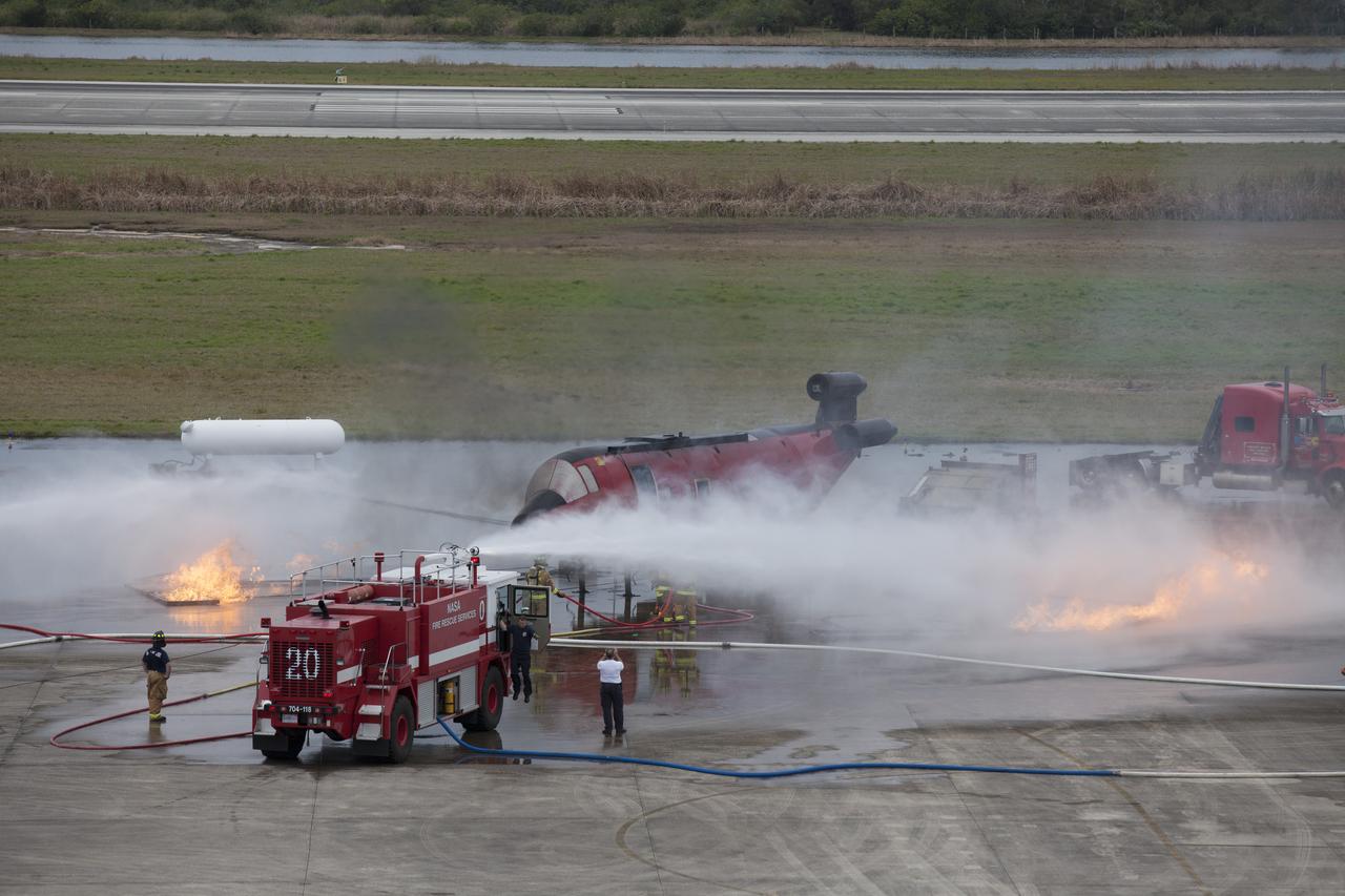
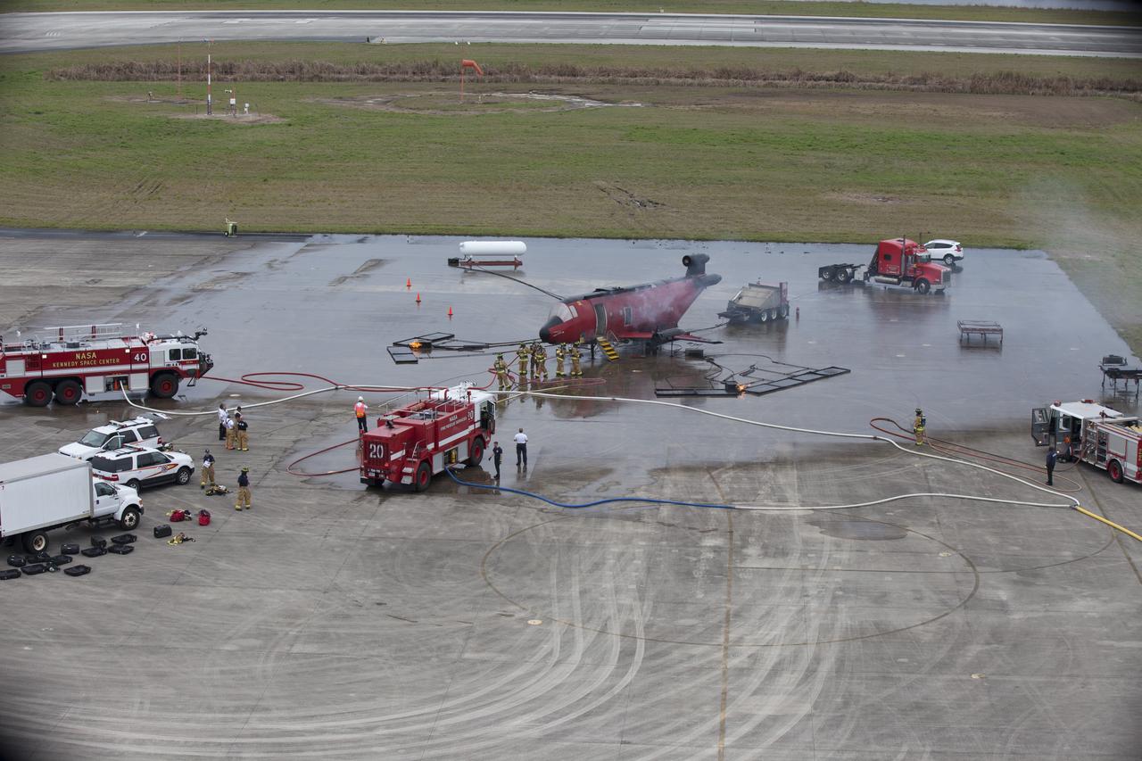
CAPE CANAVERAL, Fla. - Special Rescue Operations firefighters with NASA Fire Rescue Services in the Protective Services Office at NASA’s Kennedy Space Center in Florida participate in a training exercise at the Shuttle Landing Facility. Firefighters use a fire truck to put out a fire burning close to a mock-up of a small plane and a truck. Kennedy’s firefighters recently achieved Pro Board Certification in aerial fire truck operations and completed vehicle extrication training using the Jaws of Life. The Protective Services Office is one step closer to achieving certification in vehicle machinery extrication and other rescue skills. Kennedy’s firefighters are with G4S Government Solutions Inc., on the Kennedy Protective Services Contract. Photo credit: NASA/Kim Shiflett
CAPE CANAVERAL, Fla. - Special Rescue Operations firefighters with NASA Fire Rescue Services in the Protective Services Office at NASA’s Kennedy Space Center in Florida prepare to participate in a training exercise at the Shuttle Landing Facility. A small fire is burning near a mock-up of a plane during the training exercise. Kennedy’s firefighters recently achieved Pro Board Certification in aerial fire truck operations and completed vehicle extrication training using the Jaws of Life. The Protective Services Office is one step closer to achieving certification in vehicle machinery extrication and other rescue skills. Kennedy’s firefighters are with G4S Government Solutions Inc., on the Kennedy Protective Services Contract. Photo credit: NASA/Kim Shiflett
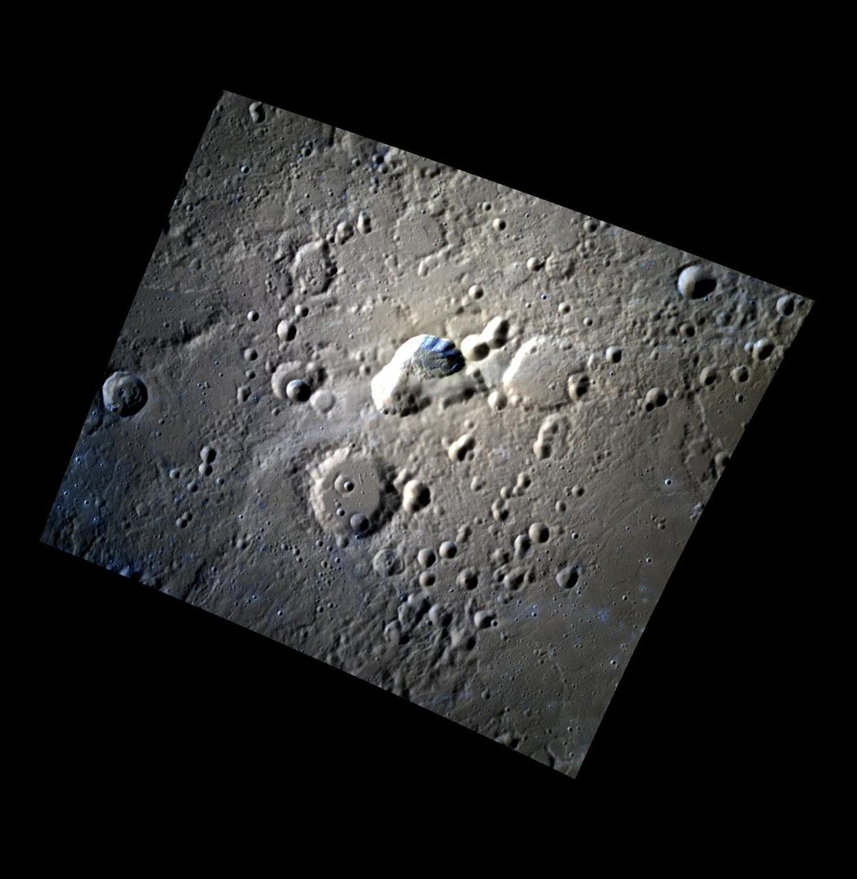
Enceladus Keeps the Home Fires Burning
On August 23, 2013, the Moderate Resolution Imaging Spectroradiometer (MODIS) on NASA’s Aqua satellite acquired this image of the drought-fueled Rim fire burning in central California, near Yosemite National Park. Red outlines indicate hot spots where MODIS detected unusually warm surface temperatures associated with fires. Winds blew a thick smoke plume toward the northeast. A smaller fire—American fire—burned to the north. The lower image is a photograph that shows the fire burning at night on August 21. Started on August 17, 2013, the fast-moving fire had already charred more than 100,000 acres (40,000 hectares) by August 23, despite the efforts of more than 2,000 firefighters. Hundreds of people were forced to evacuate their homes, and roads in the area were closed. As of August 23, no structures had been reported destroyed, but the fire threatened the towns of Groveland and Pine Mountain Lake. By late August, wildfires had burned 3.4 million acres in the United States, making 2013 somewhat less active than other recent years. Over the last decade, fires charred 5.7 million acres on average by August 22, according to statistics published the National Interagency Fire Center. NASA image by Jeff Schmaltz, LANCE/EOSDIS Rapid Response. Caption by Adam Voiland. Instrument: Aqua - MODIS Credit: <b><a href="http://www.earthobservatory.nasa.gov/" rel="nofollow"> NASA Earth Observatory</a></b> <b><a href="http://www.nasa.gov/audience/formedia/features/MP_Photo_Guidelines.html" rel="nofollow">NASA image use policy.</a></b> <b><a href="http://www.nasa.gov/centers/goddard/home/index.html" rel="nofollow">NASA Goddard Space Flight Center</a></b> enables NASA’s mission through four scientific endeavors: Earth Science, Heliophysics, Solar System Exploration, and Astrophysics. Goddard plays a leading role in NASA’s accomplishments by contributing compelling scientific knowledge to advance the Agency’s mission. <b>Follow us on <a href="http://twitter.com/NASA_GoddardPix" rel="nofollow">Twitter</a></b> <b>Like us on <a href="http://www.facebook.com/pages/Greenbelt-MD/NASA-Goddard/395013845897?ref=tsd" rel="nofollow">Facebook</a></b> <b>Find us on <a href="http://instagram.com/nasagoddard?vm=grid" rel="nofollow">Instagram</a></b>
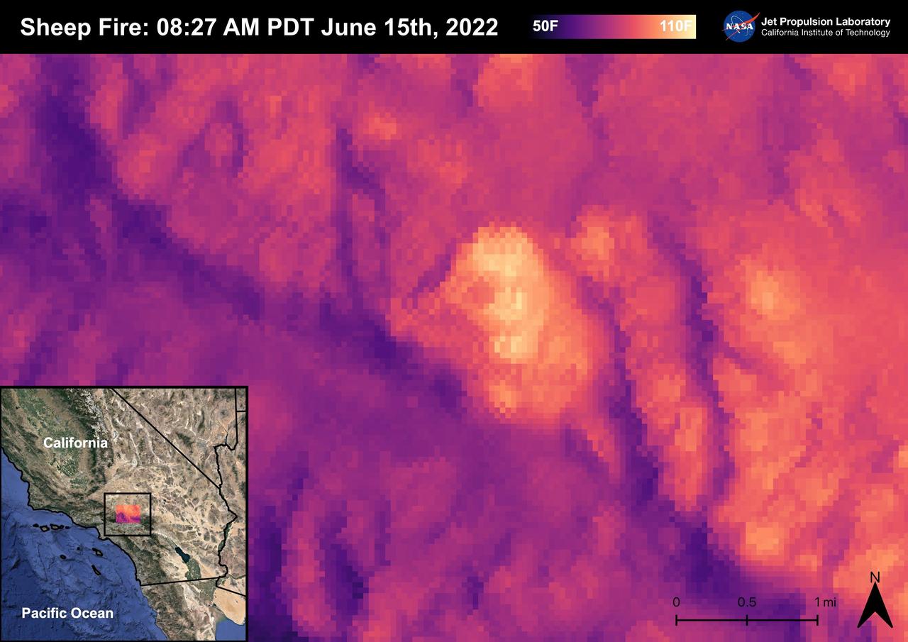
The Sheep Fire started on June 12th, 2022, Northeast of the town of Wrightwood in San Bernardino County. The fire burned 865 acres and was contained on June 19th, 2022. Due to the proximity of the Sheep Fire to Wrightwood, the town was evacuated. The Pacific Crest Trail in the San Gabriel Mountains and part of Highway 2 were closed due to the fire. There were no casualties or injuries as a result of the Sheep Fire. The fire was captured in an ECOSTRESS Land Surface Temperature image on 08:27 AM PDT on June 15th and shows the temperature of the fire surpassing 100 degrees Fahrenheit. As California is currently in a drought, there are concerns that 2022 will see a severe wildfire season; ECOSTRESS allows for the monitoring of the drought and of wildfires. ECOSTRESS is a thermal instrument on the International Space Station that measures the temperature of the ground, which is hotter than the air temperature during the day. It was launched to the space station in 2018. Its primary mission is to identify critical thresholds of water use and water stress in plants and to detect the timing, location, and predictive factors leading to plant water uptake decline and/or cessation. The nature of the high-resolution data provided by ECOSTRESS allows it to record heat related phenomena such as heat waves, droughts and wildfires. https://photojournal.jpl.nasa.gov/catalog/PIA25356
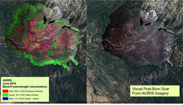
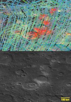
At left, a NASA AVIRIS map shows the spectral signature of the 2013 Rim fire in and near Yosemite National Park, California, the third largest in the state's history, burning more than 250,000 acres. Almost two years later, forest restoration efforts are still ongoing. Charred wood has a strong signal in the wavelengths shown here in red, so areas that are predominantly red in the image were heavily burned. The wavelengths of green, visible light (the color of vegetation) appear on this map as blue. There are no solid blue patches on the map because no large areas of green, living foliage survived the fire. Purple, a mixture of red and blue, indicates an area where charred wood and living plants are mingled. This image provides far more information about the state of the post-fire vegetation than the view on the right, which is what an observer flying overhead would see. AVIRIS is a unique NASA science instrument that measures the complete solar reflected portion of the electromagnetic spectrum with unmatched spectral range, calibration accuracy and signal-to-noise ratio. AVIRIS spectra are measured from 370 to 2,500 nanometers at 9.8-nanometer intervals. Images are acquired with 20-, 6- or 4-meter (66-, 20, or 13-feet) spatial resolution with a 34 degree swath. Up to 100 million spectra are measured in image format on each flight. The spectral image measurements are provided in orthorectified (geometrically corrected) format for direct use by scientists. http://photojournal.jpl.nasa.gov/catalog/PIA19361
A new Aircraft Rescue and Fire Fighting vehicle is backdropped by the Shuttle Landing Facility runway at NASA’s Kennedy Space Center in Florida. The state-of-the-art truck replaces a 28-year-old vehicle. Kennedy is upgrading its fleet of emergency vehicles to enhance its safety and security posture at the growing, multi-user spaceport.
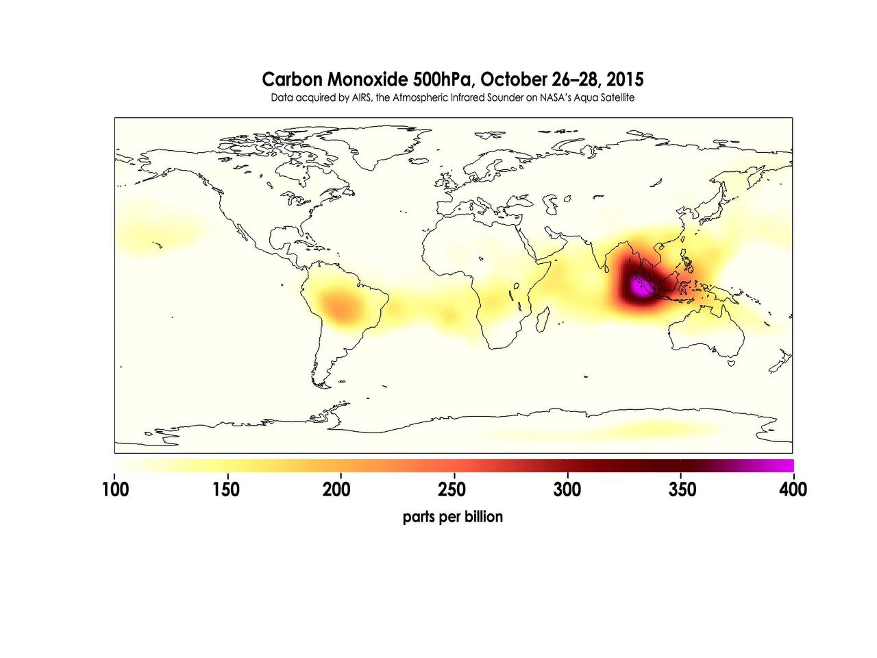
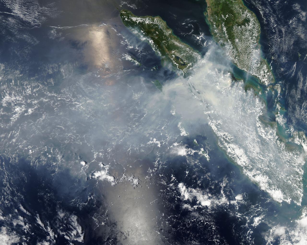
Widespread forest fires across Indonesia have burned tens of thousands of acres over three months, causing high levels of pollution, loss of life, and billions of dollars to the Indonesian government. It is estimated that more than 43 million people have been inhaling toxic fumes, and large parts of Indonesia have been placed in a state of emergency. Most of the fires are believed to have been set to clear farmland during the dry season, but a long term drought enhanced by El Niño conditions have contributed to the fires remaining unchecked due to lack of rain. These images made with data acquired by AIRS, the Atmospheric Infrared Sounder on NASA's Aqua Satellite, show the global concentration of carbon monoxide at the 500hPa pressure level, or approximately 18,000 feet (5,500 meters) altitude. The data are an average of measurements taken over three days, from October 14 through 16, and October 26 through 28, and the high concentration and large extent of the fires over Indonesia are quite apparent. While the scale for this image extends to 400 parts per billion, local values of carbon monoxide can be significantly higher. http://photojournal.jpl.nasa.gov/catalog/PIA20042
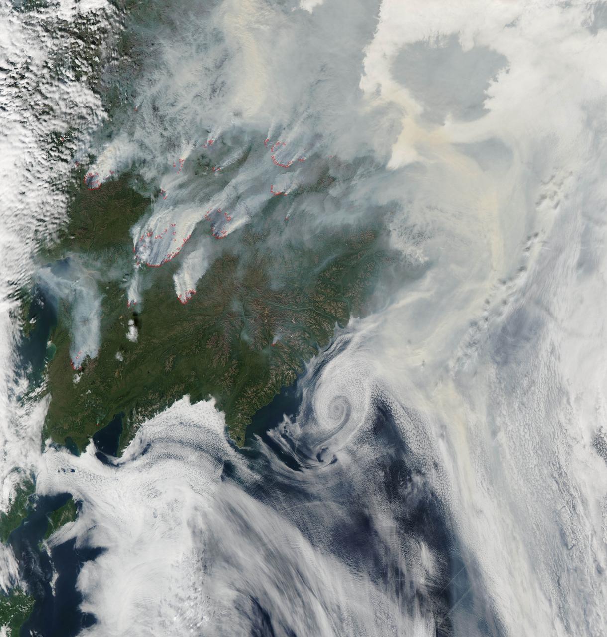
NASA image acquired August 1, 2010 Intense fires continued to burn in the boreal forests of eastern Siberia on August 1, 2010. The fires are outlined in red in this image, acquired by the Moderate Resolution Imaging Spectroradiometer (MODIS) on NASA’s Aqua satellite. The fires span the borders of Russia’s Chukotskiy, Magadan, and Koryakskiy provinces. Burning in coniferous (evergreen) forests, the fires blanketed northeastern Siberia with thick brown smoke. The smoke hugs the ground near the fires, filling valleys, and soars over clouds farther away from the flames. On August 1, the smoke flowed north from the fires and over the Arctic Ocean. A wide view of the Arctic shows the smoke crossing the Bering Strait and clouding skies over northern Alaska. This image is available in additional resolutions from the MODIS Rapid Response Team here: <a href="http://rapidfire.sci.gsfc.nasa.gov/gallery/?2010213-0801/Russia.A2010213.0045.2km.jpg" rel="nofollow">rapidfire.sci.gsfc.nasa.gov/gallery/?2010213-0801/Russia....</a> To view more images from this event go to: <a href="http://earthobservatory.nasa.gov/NaturalHazards/event.php?id=44561" rel="nofollow">earthobservatory.nasa.gov/NaturalHazards/event.php?id=44561</a> NASA image courtesy Jeff Schmaltz, MODIS Rapid Response Team at NASA GSFC. Caption by Holli Riebeek Instrument: Aqua - MODIS <b><a href="http://www.nasa.gov/centers/goddard/home/index.html" rel="nofollow">NASA Goddard Space Flight Center</a></b> is home to the nation's largest organization of combined scientists, engineers and technologists that build spacecraft, instruments and new technology to study the Earth, the sun, our solar system, and the universe. <b>Follow us on <a href="http://twitter.com/NASA_GoddardPix" rel="nofollow">Twitter</a></b> <b>Join us on <a href="http://www.facebook.com/pages/Greenbelt-MD/NASA-Goddard/395013845897?ref=tsd" rel="nofollow">Facebook</a><b></b></b>
CAPE CANAVERAL, Fla. - Special Rescue Operations firefighters with NASA Fire Rescue Services in the Protective Services Office at NASA’s Kennedy Space Center in Florida participate in a training exercise at the Shuttle Landing Facility. Firefighters use fire trucks and hoses to extinguish flames burning on and around a mock-up of a small plane. Kennedy’s firefighters recently achieved Pro Board Certification in aerial fire truck operations and completed vehicle extrication training using the Jaws of Life. The Protective Services Office is one step closer to achieving certification in vehicle machinery extrication and other rescue skills. Kennedy’s firefighters are with G4S Government Solutions Inc., on the Kennedy Protective Services Contract. Photo credit: NASA/Kim Shiflett
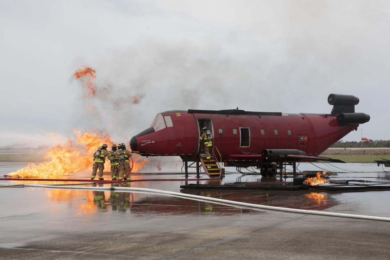
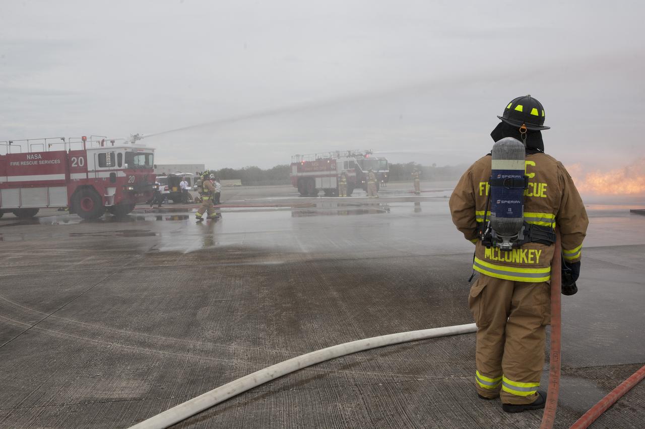
CAPE CANAVERAL, Fla. - Special Rescue Operations firefighters with NASA Fire Rescue Services in the Protective Services Office at NASA’s Kennedy Space Center in Florida participate in a training exercise at the Shuttle Landing Facility. Firefighters, wearing protective gear, use hoses to put out a fire burning near the mock-up of a small plane as another firefighter checks inside the plane. Kennedy’s firefighters recently achieved Pro Board Certification in aerial fire truck operations and completed vehicle extrication training using the Jaws of Life. The Protective Services Office is one step closer to achieving certification in vehicle machinery extrication and other rescue skills. Kennedy’s firefighters are with G4S Government Solutions Inc., on the Kennedy Protective Services Contract. Photo credit: NASA/Kim Shiflett
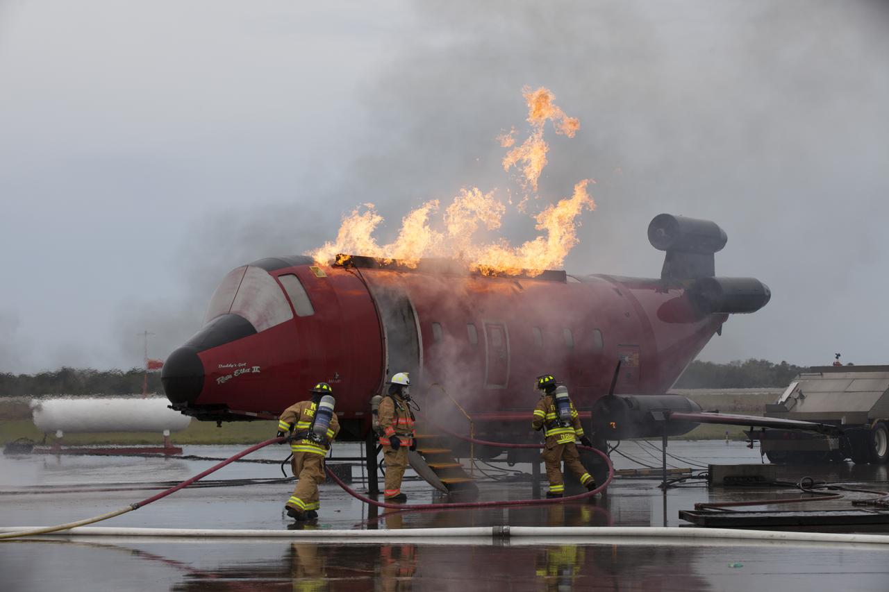
CAPE CANAVERAL, Fla. - Special Rescue Operations firefighters with NASA Fire Rescue Services in the Protective Services Office at NASA’s Kennedy Space Center in Florida participate in a training exercise at the Shuttle Landing Facility. Firefighters, wearing protective gear, use hoses to put out a fire burning on a mock-up of a small plane. Kennedy’s firefighters recently achieved Pro Board Certification in aerial fire truck operations and completed vehicle extrication training using the Jaws of Life. The Protective Services Office is one step closer to achieving certification in vehicle machinery extrication and other rescue skills. Kennedy’s firefighters are with G4S Government Solutions Inc., on the Kennedy Protective Services Contract. Photo credit: NASA/Kim Shiflett
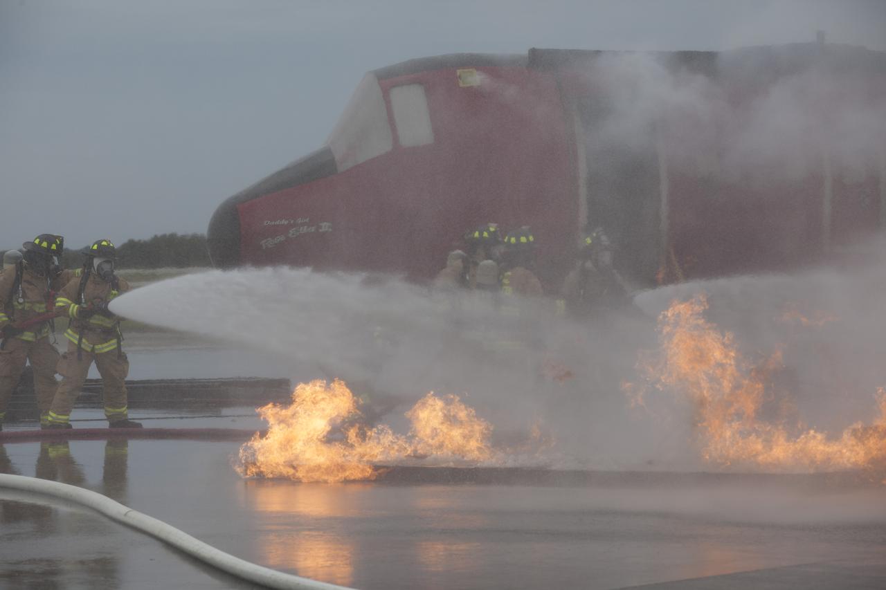
CAPE CANAVERAL, Fla. - Special Rescue Operations firefighters with NASA Fire Rescue Services in the Protective Services Office at NASA’s Kennedy Space Center in Florida participate in a training exercise at the Shuttle Landing Facility. Firefighters, wearing protective gear, use hoses to put out a fire burning close to a mock-up of a small plane. Kennedy’s firefighters recently achieved Pro Board Certification in aerial fire truck operations and completed vehicle extrication training using the Jaws of Life. The Protective Services Office is one step closer to achieving certification in vehicle machinery extrication and other rescue skills. Kennedy’s firefighters are with G4S Government Solutions Inc., on the Kennedy Protective Services Contract. Photo credit: NASA/Kim Shiflett
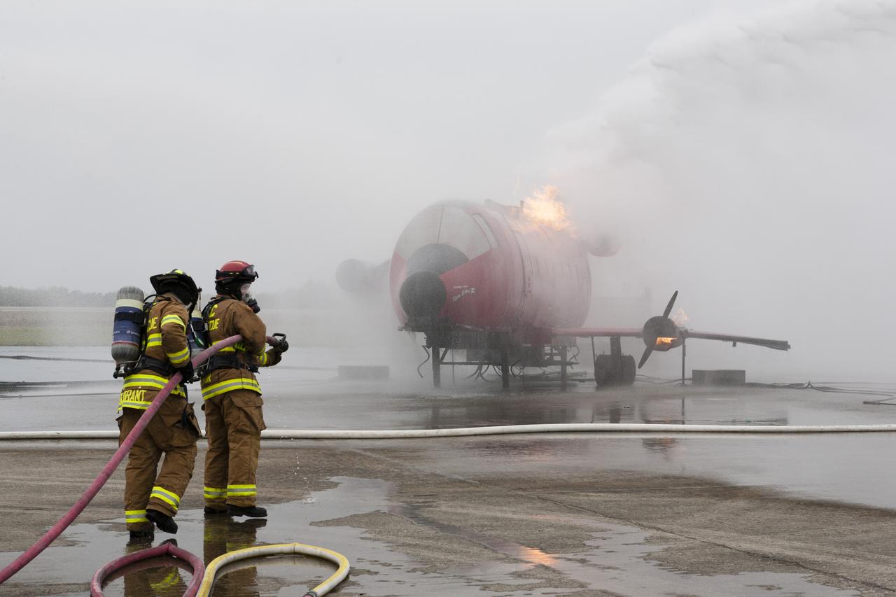
CAPE CANAVERAL, Fla. - During a training exercise, Special Rescue Operations firefighters with NASA Fire Rescue Services in the Protective Services Office at NASA’s Kennedy Space Center in Florida use hoses to put out a fire burning on a mock-up of a small plane at the Shuttle Landing Facility. They are wearing protective gear for the training exercise. Kennedy’s firefighters recently achieved Pro Board Certification in aerial fire truck operations and completed vehicle extrication training using the Jaws of Life. The Protective Services Office is one step closer to achieving certification in vehicle machinery extrication and other rescue skills. Kennedy’s firefighters are with G4S Government Solutions Inc., on the Kennedy Protective Services Contract. Photo credit: NASA/Kim Shiflett
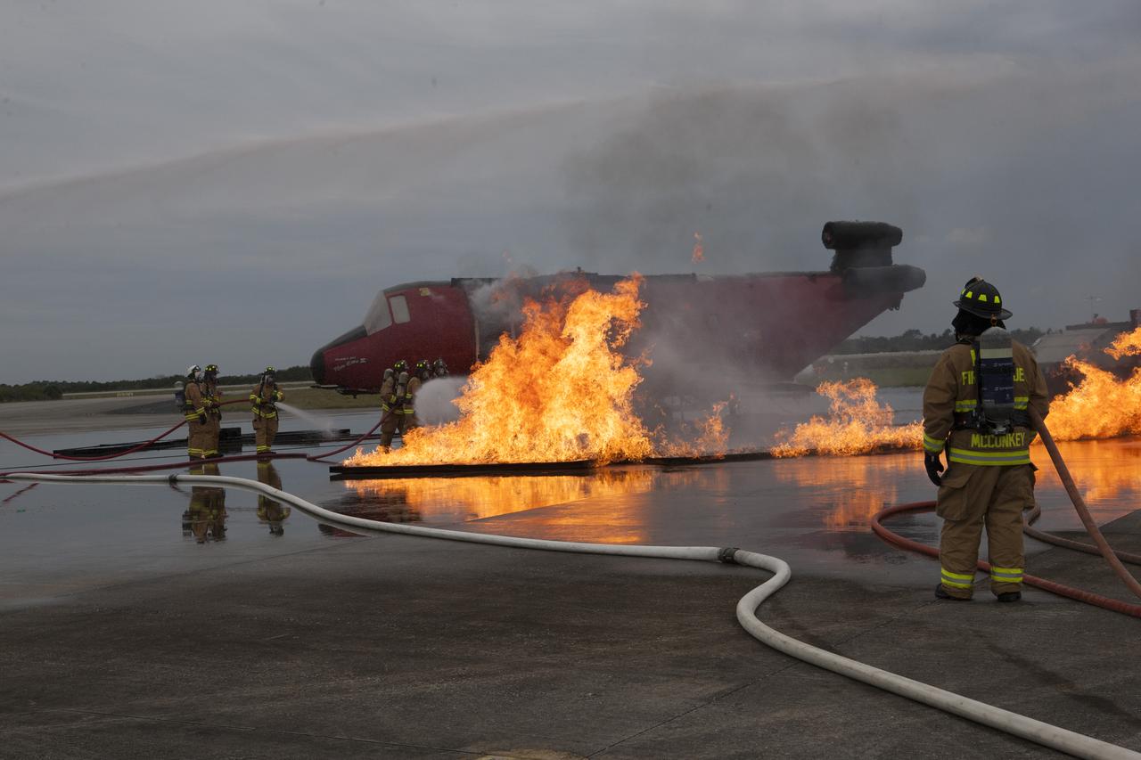
CAPE CANAVERAL, Fla. - Special Rescue Operations firefighters with NASA Fire Rescue Services in the Protective Services Office at NASA’s Kennedy Space Center in Florida participate in a training exercise at the Shuttle Landing Facility. Firefighters, wearing protective gear, use hoses to put out a fire burning near the mock-up of a small plane. Kennedy’s firefighters recently achieved Pro Board Certification in aerial fire truck operations and completed vehicle extrication training using the Jaws of Life. The Protective Services Office is one step closer to achieving certification in vehicle machinery extrication and other rescue skills. Kennedy’s firefighters are with G4S Government Solutions Inc., on the Kennedy Protective Services Contract. Photo credit: NASA/Kim Shiflett
Fires burning in Sumatra continued to pour smoke over the region in mid-March, 2014, bringing air quality to dangerous levels. The Moderate Resolution Imaging Spectroradiometer (MODIS) aboard NASA’s Aqua satellite captured this true-color image of the smoke and haze across the region on March 12. According to the Jakarta Post, on March 12 the Sumatra Environmental Laboratory reported that 10 of 12 spots in Riau had an air quality of index above 300 on the Pollutant Standards Index (PSI), which is considered hazardous. Hazardous air quality had been recorded in some of the locations for 11 consecutive days. The province of Riau is located in the central eastern coast of Sumatra and, in this image, is hidden under thick bands of light gray smoke. Intense fires, reported as deliberately set to clear land, were burning in the Giam Siak Kecil-Bukit Batu biosphere reserve. This reserve contains over 700,000 hectares of sensitive peat forest that sustains a wide range of plant and animal species, including the Sumatra tiger, elephant, tapir and sun bear. With visibility as low as 500 m (1640 ft), 58 flights were cancelled in Pekanbaru, the capital of Riau province, on March 11. Schools were closed across the region, with 43,000 students affected in Payakumbuh, West Sumatra. On March 14, Selangor, Malaysia closed 203 schools, affecting 211,700 pupils, until the air quality improved. On that same day, according to Riau Health Agency, more than 55,000 residents in the province were suffering from haze-related illnesses, including acute respiratory infections, pneumonia and skin and eye irritation. Poor air quality not only affected transportation, human health and the ecosystem, but has had significant economic impacts. On March 17, Reuters reported that the poor air quality had forced Chevron, the country’s biggest oil producer, to close hundreds of its wells. As a result, Indonesia’s crude oil output dropped to 790,000 barrels per day (bpd) – significantly lower than the 870,000 bpd target. Although slash-and-burn techniques, which use fire to clear land, is illegal in Indonesia, the practice is still widespread, with approximately 99% of fires in Sumatra considered to be intentionally set. This year’s early agricultural fires began in February in Riau Province, home to palm-oil and pulpwood plantations. The emergency has prompted strong government response, including a shoot-on-sight order for any suspects involved in land burning activities that resisted arrest. According to the Jakarta Post, police have named as many as 60 suspected-fire starters in Riau. Credit: NASA/GSFC/Jeff Schmaltz/MODIS Land Rapid Response Team <b><a href="http://www.nasa.gov/audience/formedia/features/MP_Photo_Guidelines.html" rel="nofollow">NASA image use policy.</a></b> <b><a href="http://www.nasa.gov/centers/goddard/home/index.html" rel="nofollow">NASA Goddard Space Flight Center</a></b> enables NASA’s mission through four scientific endeavors: Earth Science, Heliophysics, Solar System Exploration, and Astrophysics. Goddard plays a leading role in NASA’s accomplishments by contributing compelling scientific knowledge to advance the Agency’s mission. <b>Follow us on <a href="http://twitter.com/NASAGoddardPix" rel="nofollow">Twitter</a></b> <b>Like us on <a href="http://www.facebook.com/pages/Greenbelt-MD/NASA-Goddard/395013845897?ref=tsd" rel="nofollow">Facebook</a></b> <b>Find us on <a href="http://instagram.com/nasagoddard?vm=grid" rel="nofollow">Instagram</a></b>
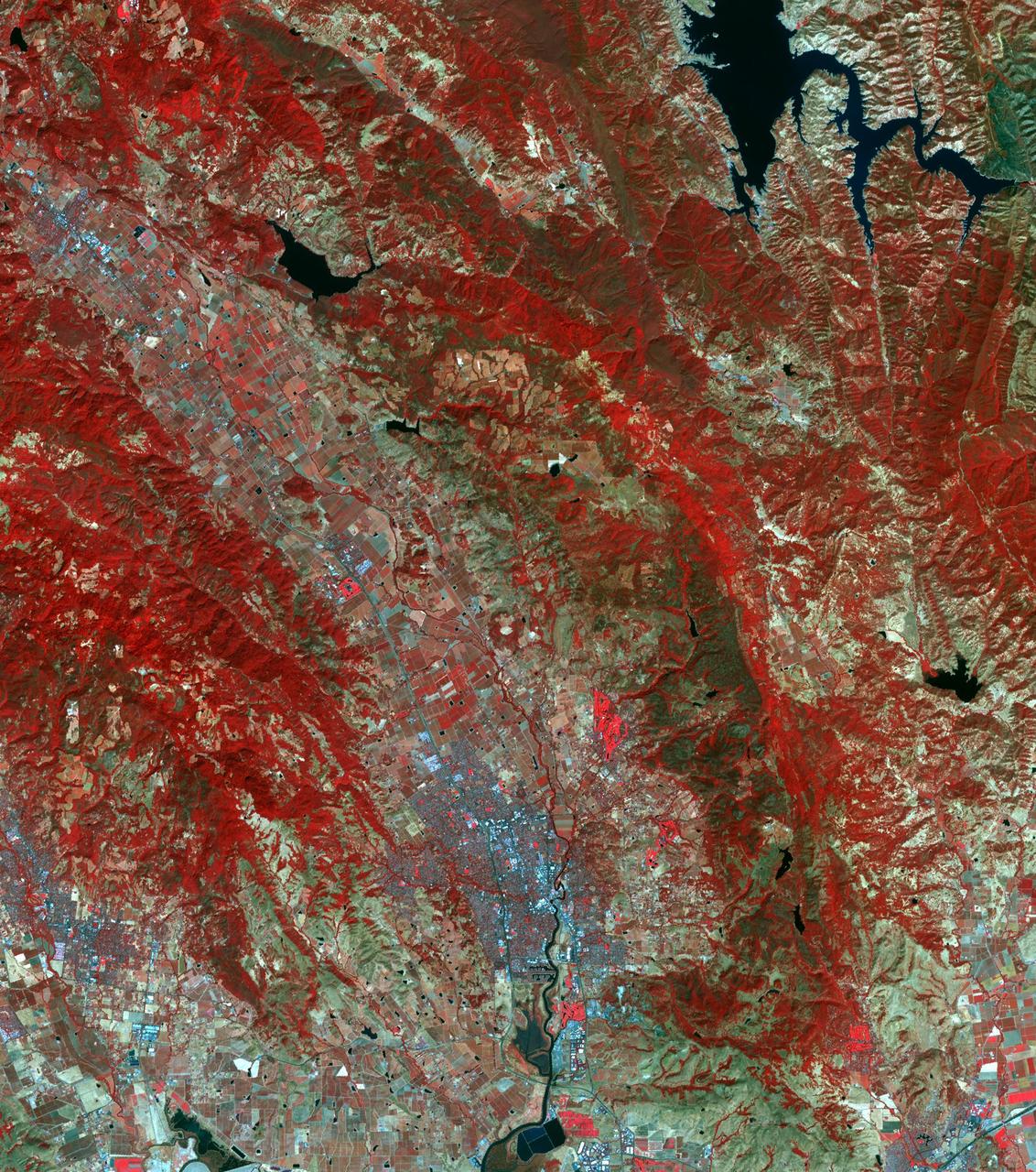
The major fires burning in Northern California's wine country continue to burn relentlessly, forcing additional mass evacuations. The Advanced Spaceborne Thermal Emission and Reflection Radiometer (ASTER) instrument on NASA's Terra satellite acquired this image the morning of Oct. 12, 2017. The fires have consumed hundreds of thousands of acres, resulting in significant loss of life, injuries and heavy property losses. The city of Santa Rosa is in the upper left corner; Napa is in the upper right; and Sonoma is in the center. In the image, vegetation is depicted in red and smoke is blue-gray. Active fires and hotspots, detected on ASTER's thermal infrared channels, are in yellow. The background colors have been subdued to make the yellow hotspots more apparent. The image covers an area of 35 by 57 miles (57 by 91 kilometers) and is located near 38.3 degrees north, 122.5 degrees west. https://photojournal.jpl.nasa.gov/catalog/PIA22046
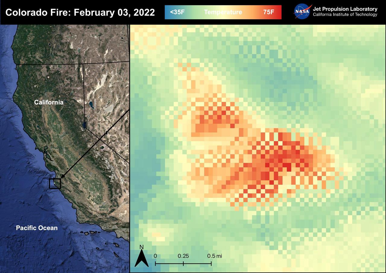
The Colorado Fire began on January 21st, 2022 was started by an escaped fire by the Palo Colorado Road. The wildfire burned 687 acres between Carmel-by-the-Sea and Big Sur. The Colorado Fire was driven towards the coast by strong winds leading to the shut down of the Bixby Bridge and a section of Highway 1. The fire was completely contained as of February 5th, 2022. No injuries or causalities have been reported; one structure was destroyed. The image above shows the fire captured in a Land Surface Temperature image from ECOSTRESS on February 3rd, 2022 at 01:11 PM PDT. As California is currently in a drought, there are concerns that 2022 will see a severe wildfire season; ECOSTRESS allows for the monitoring of the drought and of wildfires. ECOSTRESS is a thermal instrument on the International Space Station that measures the temperature of the ground, which is hotter than the air temperature during the day. It was launched to the space station in 2018. Its primary mission is to identify critical thresholds of water use and water stress in plants and to detect the timing, location, and predictive factors leading to plant water uptake decline and/or cessation. The nature of the high-resolution data provided by ECOSTRESS allows it to record heat related phenomena such as heat waves, droughts and wildfires. https://photojournal.jpl.nasa.gov/catalog/PIA25280
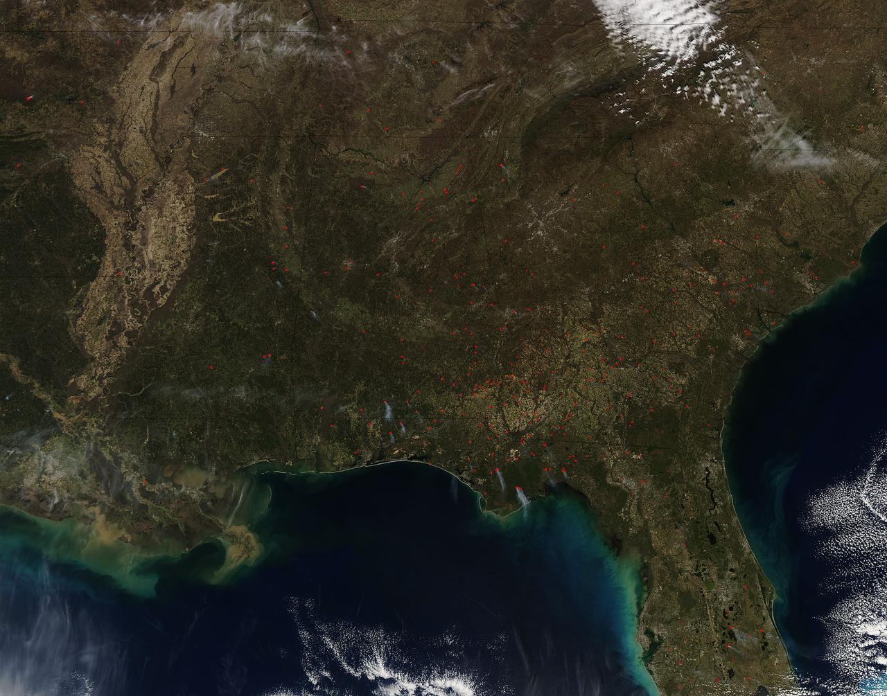
Fires both wild and prescribed dot the landscape of the southeastern portion of the United States. Wildfires are those that occur naturally with lightning strikes or are set by careless humans. Prescribed fires are those deliberately set by land management authorities to take out underlying brush and dead grass so that in the event of a wildfire there is not sufficient fuel for that fire to spread too far. The Southern Area Coordination Center for fire management has this information on its report for February 21, 2017. • Fires that have broken out recently (known as Initial Attack Activity): 198 fires for 2,292 acres • Ongoing Uncontained Large Fires: 3 fires for 5,947 acres • Other Fires reported through alternate channels: 56 fires for 1,400 acres • Prescribed Fire Activity: State and/or Federal Lands – 1,974 prescribed fires for 38,533 acres in AL, FL & GA The bulk of the fires seen in the image taken by the Aqua satellite using the onboard MODIS (Moderate Resolution Imaging Spectroradiometer) instrument on February 16, 2017 appear to be prescribed fires. Actively burning areas, detected by MODIS’s thermal bands, are outlined in red and when combined with smoke are indicative of fire. NASA image courtesy Jeff Schmaltz LANCE/EOSDIS MODIS Rapid Response Team, GSFC. Caption by Lynn Jenner with information from the Southern Area Coordination Center. <b><a href="http://www.nasa.gov/audience/formedia/features/MP_Photo_Guidelines.html" rel="nofollow">NASA image use policy.</a></b> <b><a href="http://www.nasa.gov/centers/goddard/home/index.html" rel="nofollow">NASA Goddard Space Flight Center</a></b> enables NASA’s mission through four scientific endeavors: Earth Science, Heliophysics, Solar System Exploration, and Astrophysics. Goddard plays a leading role in NASA’s accomplishments by contributing compelling scientific knowledge to advance the Agency’s mission. <b>Follow us on <a href="http://twitter.com/NASAGoddardPix" rel="nofollow">Twitter</a></b> <b>Like us on <a href="http://www.facebook.com/pages/Greenbelt-MD/NASA-Goddard/395013845897?ref=tsd" rel="nofollow">Facebook</a></b> <b>Find us on <a href="http://instagrid.me/nasagoddard/?vm=grid" rel="nofollow">Instagram</a></b>
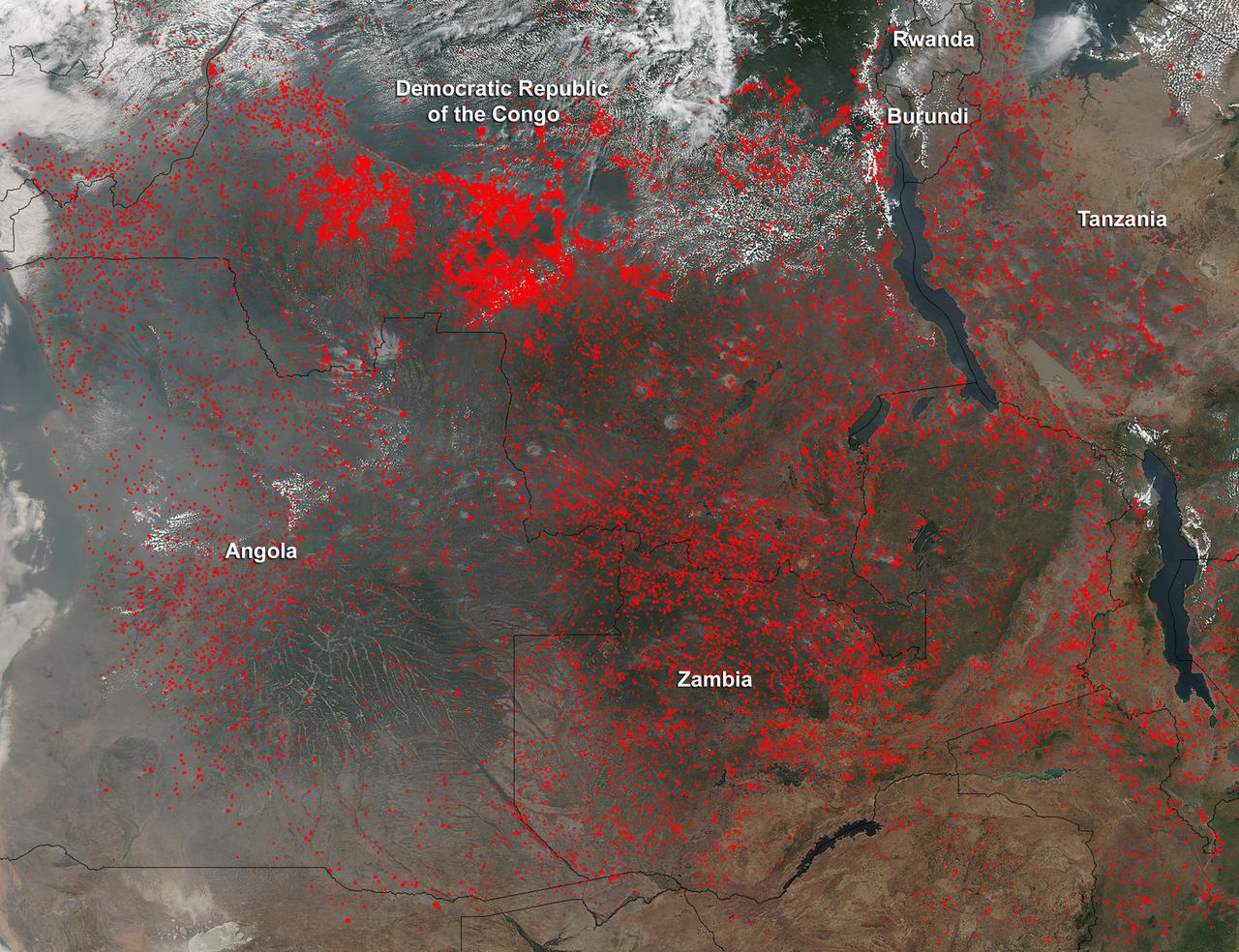
Widespread agricultural burning continues throughout central Africa. Smoke and fires in several countries were seen by the Suomi NPP satellite. Most of the fires were burning in the southern region of the Democratic Republic of the Congo, Tanzania, Zambia and Angola. NASA-NOAA's Suomi NPP satellite's Visible Infrared Imaging Radiometer Suite (VIIRS) instrument captured a look at multiple fires and smoke on August 1 at 7:55 a.m. EDT (11:55 UTC). Actively burning areas, detected by VIIRS are outlined in red. Credit: NASA/Jeff Schmaltz/NASA Goddard Rapid Response Team <b><a href="http://www.nasa.gov/audience/formedia/features/MP_Photo_Guidelines.html" rel="nofollow">NASA image use policy.</a></b> <b><a href="http://www.nasa.gov/centers/goddard/home/index.html" rel="nofollow">NASA Goddard Space Flight Center</a></b> enables NASA’s mission through four scientific endeavors: Earth Science, Heliophysics, Solar System Exploration, and Astrophysics. Goddard plays a leading role in NASA’s accomplishments by contributing compelling scientific knowledge to advance the Agency’s mission. <b>Follow us on <a href="http://twitter.com/NASAGoddardPix" rel="nofollow">Twitter</a></b> <b>Like us on <a href="http://www.facebook.com/pages/Greenbelt-MD/NASA-Goddard/395013845897?ref=tsd" rel="nofollow">Facebook</a></b> <b>Find us on <a href="http://instagrid.me/nasagoddard/?vm=grid" rel="nofollow">Instagram</a></b>
According to the NBCnews.com, Southern California firefighters were battling a growing, brush-fueled wildfire early Friday that had reached the beach in Ventura County and was pushing toward the upscale city of Malibu, officials said. Dubbed the Springs Fire, this "monster" of a wildfire has been made worse by howling Santa Ana winds and unusually dry vegetation. As of 2 am local time in California on Friday the 3rd, it was within "seven or eight miles" of Malibu, Ventura County Fire Department spokesman Bill Nash said. Weather conditions are not cooperating in the containment of this fire. The Weather Channel has predicted dry winds from offshore that will bring gusts of 40 to 50 miles per hour to the Southern California region on Friday the 3rd which could easily spread the fire. A complication to the winds is the extremely dry plant life left from a season in which only about five inches of rain fell in the area. The Springs Fire grew to 10,000 acres and was ten percent contained as of early Friday morning, according to the California Department of Forestry and Fire Prevention. Evacuations took place Thursday, and as of Friday morning 15 homes had been damaged. More than 2,000 homes and 100 commercial properties were under threat from the fire and those numbers could grow with weather conditions today (May 3). Currently the fire is burning in a rural area outside of Malibu, but it doesn't have to go very far to get to some expensive homes and more populated areas. It's current direction has it burning down the mountainside toward Malibu. Firefighters expect to receive help from tankers and helicopters in the air Friday morning, according to a release from the Ventura County Fire Department. The cause of the fire remained under investigation Friday. There had been no lightning or other natural fire-starting phenomenon in the area when the blaze began, Nash said. This natural-color satellite image was collected by the Moderate Resolution Imaging Spectroradiometer (MODIS) aboard the Aqua satellite on May 02, 2013. Actively burning areas, detected by MODIS’s thermal bands, are outlined in red. NASA image courtesy Jeff Schmaltz LANCE/EOSDIS MODIS Rapid Response Team, GSFC. Caption by Lynn Jenner with information from NBCnews.com <b><a href="http://www.nasa.gov/audience/formedia/features/MP_Photo_Guidelines.html" rel="nofollow">NASA image use policy.</a></b> <b><a href="http://www.nasa.gov/centers/goddard/home/index.html" rel="nofollow">NASA Goddard Space Flight Center</a></b> enables NASA’s mission through four scientific endeavors: Earth Science, Heliophysics, Solar System Exploration, and Astrophysics. Goddard plays a leading role in NASA’s accomplishments by contributing compelling scientific knowledge to advance the Agency’s mission. <b>Follow us on <a href="http://twitter.com/NASA_GoddardPix" rel="nofollow">Twitter</a></b> <b>Like us on <a href="http://www.facebook.com/pages/Greenbelt-MD/NASA-Goddard/395013845897?ref=tsd" rel="nofollow">Facebook</a></b> <b>Find us on <a href="http://instagram.com/nasagoddard?vm=grid" rel="nofollow">Instagram</a></b>

A member of the Artemis 1 launch team participates in validation testing inside Firing Room 1 in the Launch Control Center at NASA’s Kennedy Space Center in Florida on July 11, 2019. The launch team includes personnel with NASA’s Exploration Ground Systems (EGS) and Jacobs Test and Operations Contract (TOSC). The simulation was designed to validate the firing room consoles and communications systems, as well as the new Spaceport Command and Control System (SCCS), which will operate, monitor and coordinate ground equipment in preparation for Artemis 1, the uncrewed first flight of the Space Launch System rocket and Orion spacecraft.

Members of the Artemis 1 launch team, including personnel with NASA’s Exploration Ground Systems (EGS) and Jacobs Test and Operations Contract (TOSC), participate in validation testing inside Firing Room 1 in the Launch Control Center at NASA’s Kennedy Space Center in Florida on July 11, 2019. The simulation was designed to validate the firing room consoles and communications systems, as well as the new Spaceport Command and Control System (SCCS), which will operate, monitor and coordinate ground equipment in preparation for Artemis 1, the uncrewed first flight of the Space Launch System rocket and Orion spacecraft.

Jeremy Graeber, chief NASA test director, participates in validation testing inside Firing Room 1 in the Launch Control Center at NASA’s Kennedy Space Center in Florida on July 11, 2019. The Artemis 1 launch team includes personnel with NASA’s Exploration Ground Systems (EGS) and Jacobs Test and Operations Contract (TOSC). The simulation was designed to validate the firing room consoles and communications systems, as well as the new Spaceport Command and Control System (SCCS), which will operate, monitor and coordinate ground equipment in preparation for Artemis 1, the uncrewed first flight of the Space Launch System rocket and Orion spacecraft.
Members of the Artemis 1 launch team, including personnel with NASA’s Exploration Ground Systems (EGS) and Jacobs Test and Operations Contract (TOSC), participate in validation testing inside Firing Room 1 in the Launch Control Center at NASA’s Kennedy Space Center in Florida on July 11, 2019. The team includes personnel with NASA’s Exploration Ground Systems (EGS) and Jacobs Test and Operations Contract (TOSC). The simulation was designed to validate the firing room consoles and communications systems, as well as the new Spaceport Command and Control System (SCCS), which will operate, monitor and coordinate ground equipment in preparation for Artemis 1, the uncrewed first flight of the Space Launch System rocket and Orion spacecraft.
From left, Jeremy Graeber, chief NASA test director, and Charlie Blackwell-Thompson, Artemis 1 launch director, participate in validation testing inside Firing Room 1 in the Launch Control Center at NASA’s Kennedy Space Center in Florida on July 11, 2019. The launch team includes personnel with NASA’s Exploration Ground Systems (EGS) and Jacobs Test and Operations Contract (TOSC). The simulation was designed to validate the firing room consoles and communications systems, as well as the new Spaceport Command and Control System (SCCS), which will operate, monitor and coordinate ground equipment in preparation for Artemis 1, the uncrewed first flight of the Space Launch System rocket and Orion spacecraft.

Artemis 1 Launch Director Charlie Blackwell-Thompson leads the launch team through validation testing inside Firing Room 1 in the Launch Control Center at NASA’s Kennedy Space Center in Florida on July 11, 2019. The team includes personnel with NASA’s Exploration Ground Systems (EGS) and Jacobs Test and Operations Contract (TOSC). The simulation was designed to validate the firing room consoles and communications systems, as well as the new Spaceport Command and Control System (SCCS), which will operate, monitor and coordinate ground equipment in preparation for Artemis 1, the uncrewed first flight of the Space Launch System rocket and Orion spacecraft.

Members of the Artemis 1 launch team, including personnel with NASA’s Exploration Ground Systems (EGS) and Jacobs Test and Operations Contract (TOSC), participate in validation testing inside Firing Room 1 in the Launch Control Center at NASA’s Kennedy Space Center in Florida on July 11, 2019. The simulation was designed to validate the firing room consoles and communications systems, as well as the new Spaceport Command and Control System (SCCS), which will operate, monitor and coordinate ground equipment in preparation for Artemis 1, the uncrewed first flight of the Space Launch System rocket and Orion spacecraft.

Artemis 1 Launch Director Charlie Blackwell-Thompson leads the launch team, including personnel with NASA’s Exploration Ground Systems (EGS) and Jacobs Test and Operations Contract (TOSC), through validation testing inside Firing Room 1 in the Launch Control Center at NASA’s Kennedy Space Center in Florida on July 11, 2019. The simulation was designed to validate the firing room consoles and communications systems, as well as the new Spaceport Command and Control System (SCCS), which will operate, monitor and coordinate ground equipment in preparation for Artemis 1, the uncrewed first flight of the Space Launch System rocket and Orion spacecraft.

A member of the Artemis 1 launch team participates in validation testing inside Firing Room 1 in the Launch Control Center at NASA’s Kennedy Space Center in Florida on July 11, 2019. The team includes personnel with NASA’s Exploration Ground Systems (EGS) and Jacobs Test and Operations Contract (TOSC). The simulation was designed to validate the firing room consoles and communications systems, as well as the new Spaceport Command and Control System (SCCS), which will operate, monitor and coordinate ground equipment in preparation for Artemis 1, the uncrewed first flight of the Space Launch System rocket and Orion spacecraft.

Members of the Artemis 1 launch team, including personnel with NASA’s Exploration Ground Systems (EGS) and Jacobs Test and Operations Contract (TOSC), participate in validation testing inside Firing Room 1 in the Launch Control Center at NASA’s Kennedy Space Center in Florida on July 11, 2019. The team includes personnel with NASA’s Exploration Ground Systems (EGS) and Jacobs Test and Operations Contract (TOSC). The simulation was designed to validate the firing room consoles and communications systems, as well as the new Spaceport Command and Control System (SCCS), which will operate, monitor and coordinate ground equipment in preparation for Artemis 1, the uncrewed first flight of the Space Launch System rocket and Orion spacecraft.

Members of the Artemis 1 launch team, including personnel with NASA’s Exploration Ground Systems (EGS) and Jacobs Test and Operations Contract (TOSC), participate in validation testing inside Firing Room 1 in the Launch Control Center at NASA’s Kennedy Space Center in Florida on July 11, 2019. The simulation was designed to validate the firing room consoles and communications systems, as well as the new Spaceport Command and Control System (SCCS), which will operate, monitor and coordinate ground equipment in preparation for Artemis 1, the uncrewed first flight of the Space Launch System rocket and Orion spacecraft.

Members of the Artemis 1 launch team, including personnel with NASA’s Exploration Ground Systems (EGS) and Jacobs Test and Operations Contract (TOSC), participate in validation testing inside Firing Room 1 in the Launch Control Center at NASA’s Kennedy Space Center in Florida on July 11, 2019. The simulation was designed to validate the firing room consoles and communications systems, as well as the new Spaceport Command and Control System (SCCS), which will operate, monitor and coordinate ground equipment in preparation for Artemis 1, the uncrewed first flight of the Space Launch System rocket and Orion spacecraft.

Carla Rekucki, lead NASA test director in NASA’s Exploration Ground Systems (EGS), center, and other launch team members participate in validation testing inside Firing Room 1 in the Launch Control Center at NASA’s Kennedy Space Center in Florida on July 11, 2019. The team includes personnel with NASA’s Exploration Ground Systems (EGS) and Jacobs Test and Operations Contract (TOSC). The simulation was designed to validate the firing room consoles and communications systems, as well as the new Spaceport Command and Control System (SCCS), which will operate, monitor and coordinate ground equipment in preparation for Artemis 1, the uncrewed first flight of the Space Launch System rocket and Orion spacecraft.

Members of the Artemis 1 launch team, including personnel with NASA’s Exploration Ground Systems (EGS) and Jacobs Test and Operations Contract (TOSC), participate in validation testing inside Firing Room 1 in the Launch Control Center at NASA’s Kennedy Space Center in Florida on July 11, 2019. The team includes personnel with NASA’s Exploration Ground Systems (EGS) and Jacobs Test and Operations Contract (TOSC). The simulation was designed to validate the firing room consoles and communications systems, as well as the new Spaceport Command and Control System (SCCS), which will operate, monitor and coordinate ground equipment in preparation for Artemis 1, the uncrewed first flight of the Space Launch System rocket and Orion spacecraft.

Jeremy Graeber, chief NASA test director, participates in validation testing inside Firing Room 1 in the Launch Control Center at NASA’s Kennedy Space Center in Florida on July 11, 2019. The Artemis 1 launch team includes personnel with NASA’s Exploration Ground Systems (EGS) and Jacobs Test and Operations Contract (TOSC). The simulation was designed to validate the firing room consoles and communications systems, as well as the new Spaceport Command and Control System (SCCS), which will operate, monitor and coordinate ground equipment in preparation for Artemis 1, the uncrewed first flight of the Space Launch System rocket and Orion spacecraft.

Members of the Artemis 1 launch team, including personnel with NASA’s Exploration Ground Systems (EGS) and Jacobs Test and Operations Contract (TOSC), participate in validation testing inside Firing Room 1 in the Launch Control Center at NASA’s Kennedy Space Center in Florida on July 11, 2019. The simulation was designed to validate the firing room consoles and communications systems, as well as the new Spaceport Command and Control System (SCCS), which will operate, monitor and coordinate ground equipment in preparation for Artemis 1, the uncrewed first flight of the Space Launch System rocket and Orion spacecraft.

A member of the Artemis 1 launch team participates in validation testing inside Firing Room 1 in the Launch Control Center at NASA’s Kennedy Space Center in Florida on July 11, 2019. The team includes personnel with NASA’s Exploration Ground Systems (EGS) and Jacobs Test and Operations Contract (TOSC). The simulation was designed to validate the firing room consoles and communications systems, as well as the new Spaceport Command and Control System (SCCS), which will operate, monitor and coordinate ground equipment in preparation for Artemis 1, the uncrewed first flight of the Space Launch System rocket and Orion spacecraft.

Members of the Artemis 1 launch team, including personnel with NASA’s Exploration Ground Systems (EGS) and Jacobs Test and Operations Contract (TOSC), in validation testing inside Firing Room 1 in the Launch Control Center at NASA’s Kennedy Space Center in Florida on July 11, 2019. The simulation was designed to validate the firing room consoles and communications systems, as well as the new Spaceport Command and Control System (SCCS), which will operate, monitor and coordinate ground equipment in preparation for Artemis 1, the uncrewed first flight of the Space Launch System rocket and Orion spacecraft.
The Meadow Fire in Yosemite National Park is a remote, hold-over lightning caused fire which began on September 4 and is located five miles east of Yosemite Valley, CA. The fuel burning is timber and brush. There is active fire behavior with long range spotting. The National Park Service reports that a fire, that may be a spot fire, from the Meadow lightning-caused fire, was discovered at approximately 12:30 PM, Sunday September 7. The fire is approximately 2,582 acres. It is burning within the Little Yosemite Valley on both sides of the Merced River. All trails in the area are closed. Approximately 100 hikers and backpackers were evacuated from the fire area in Little Yosemite Valley. Half-Dome, a popular tourist destination, has been closed. The fire is burning in Yosemite Wilderness. Eighty-five hikers and climbers were also evacuated from the summit of Half Dome by helicopters from the California Highway Patrol, US Department of Agriculture Forest Service, Sequoia Kings Canyon National Park, and CAL Fire. This natural-color satellite image was collected by the Moderate Resolution Imaging Spectroradiometer (MODIS) aboard the Aqua satellite on Sept. 07, 2014. Actively burning areas, detected by MODIS’s thermal bands, are outlined in red. NASA image courtesy Jeff Schmaltz, MODIS Rapid Response Team. Caption: NASA/Goddard, Lynn Jenner with information from the National Park Service and the National Interagency Coordination Center. <b><a href="http://www.nasa.gov/audience/formedia/features/MP_Photo_Guidelines.html" rel="nofollow">NASA image use policy.</a></b> <b><a href="http://www.nasa.gov/centers/goddard/home/index.html" rel="nofollow">NASA Goddard Space Flight Center</a></b> enables NASA’s mission through four scientific endeavors: Earth Science, Heliophysics, Solar System Exploration, and Astrophysics. Goddard plays a leading role in NASA’s accomplishments by contributing compelling scientific knowledge to advance the Agency’s mission. <b>Follow us on <a href="http://twitter.com/NASAGoddardPix" rel="nofollow">Twitter</a></b> <b>Like us on <a href="http://www.facebook.com/pages/Greenbelt-MD/NASA-Goddard/395013845897?ref=tsd" rel="nofollow">Facebook</a></b> <b>Find us on <a href="http://instagram.com/nasagoddard?vm=grid" rel="nofollow">Instagram</a></b>
The Aqua satellite collected this natural-color image of fires in Australia with the Moderate Resolution Imaging Spectroradiometer (MODIS) instrument on June 30, 2017. The image looks at multiple fires and smoke from those fires burning in northern Australia and the island of Bathurst on June 30, 2017. The Northern Territory fire incident map does show some incidents of grass and shrub fires, in the past 24 hours, but it also shows areas of what are called "strategic fires" which are those set by fire experts to rid an area of overgrowth, brush, dead grass and shrubs to prevent fires from spreading in the event of a lightning strike. NASA image courtesy Jeff Schmaltz, MODIS Rapid Response Team <b><a href="http://www.nasa.gov/audience/formedia/features/MP_Photo_Guidelines.html" rel="nofollow">NASA image use policy.</a></b> <b><a href="http://www.nasa.gov/centers/goddard/home/index.html" rel="nofollow">NASA Goddard Space Flight Center</a></b> enables NASA’s mission through four scientific endeavors: Earth Science, Heliophysics, Solar System Exploration, and Astrophysics. Goddard plays a leading role in NASA’s accomplishments by contributing compelling scientific knowledge to advance the Agency’s mission. <b>Follow us on <a href="http://twitter.com/NASAGoddardPix" rel="nofollow">Twitter</a></b> <b>Like us on <a href="http://www.facebook.com/pages/Greenbelt-MD/NASA-Goddard/395013845897?ref=tsd" rel="nofollow">Facebook</a></b> <b>Find us on <a href="http://instagrid.me/nasagoddard/?vm=grid" rel="nofollow">Instagram</a></b>
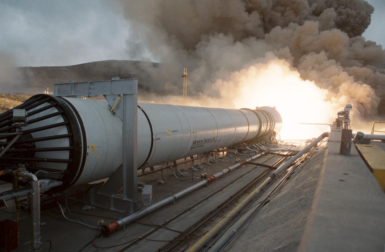
Solid Rocket Qualification Motor Firing at the Morton Thiokol facility at Brigham City, Utah on 20 April 1988.
NASA Terra satellite captured this image of fires in southern Greece.
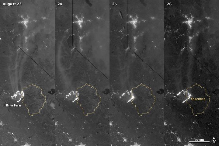
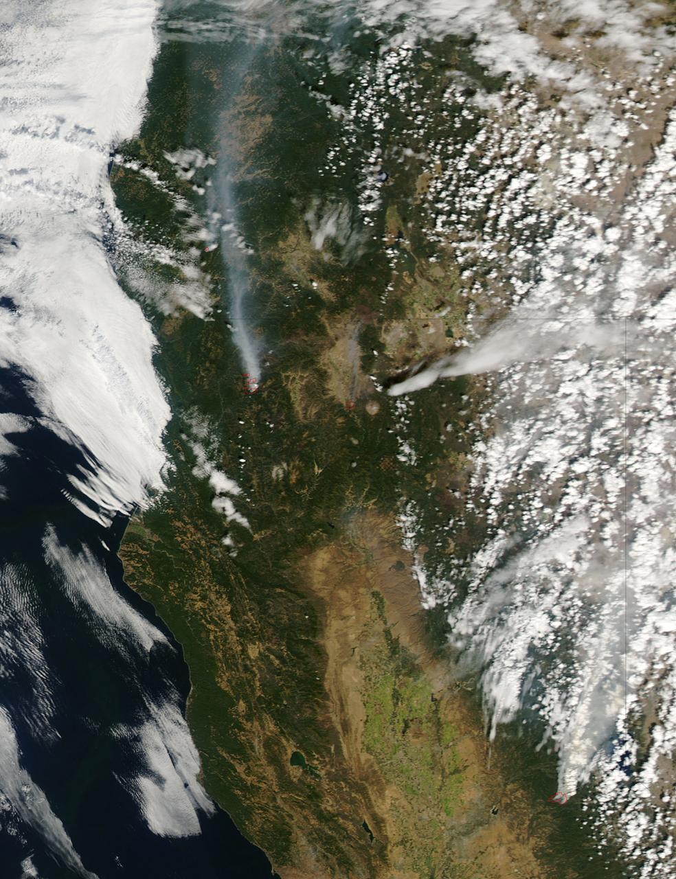
The winter of 2013 was among the driest on record for California, setting the stage for an active fire season. By August 26, the Rim Fire had made its way into the record books. At just 15 percent contained, the fire is now the 13th largest in California since records began in 1932. Apart from being large, the fire is also threatening one of the United States’ greatest natural treasures: Yosemite National Park. The Visible Infrared Imaging Radiometer Suite (VIIRS) on the Suomi NPP satellite tracked the growth of the fire between August 23 and August 26 in this series of nighttime images. The VIIRS day-night band is extremely sensitive to low light, making it possible to see the fire front from space. The brightest, most intense parts of the fire glow white, exceeding the brightness of the lights of Reno, Nevada to the north. Pale gray smoke streams north away from the fire throughout the sequence. The perimeter of the fire grows from day to day along different fronts, depending on winds and fire fighting efforts. On August 24, fire fighters focused their efforts on containing the western edge of the fire to prevent it from burning into Tuolumne City and the populated Highway 108 corridor. They also fought the eastern edge of the fire to protect Yosemite National Park. These efforts are evident in the image: Between August 23 and 24, the eastern edge of the fire held steady, and the western edge receded. The fire grew in the southeast. On the morning of August 25 fire managers reported that the fire was growing in the north and east. In the image, the most intense activity is just inside Yosemite National Park. Fire fighters reported that the Rim Fire continued to be extremely active on its eastern front on the morning of August 26, and this activity is visible in the image. By 8:00 a.m., the fire had burned 149,780 acres. The fire forced firefighters in Yosemite National Park to take measures to protect the Merced and Tuolumne Groves of Giant Sequoias, but the National Park Service reported that the trees were not in imminent danger. While parts of the park are closed, webcams show that most of the park has not been impacted. The Rim Fire started on the afternoon of August 17. It has destroyed 23 structures and threatened 4,500 other buildings. Its cause is under investigation. More details: <a href="http://1.usa.gov/18ilEAA" rel="nofollow">1.usa.gov/18ilEAA</a> NASA Earth Observatory image by Jesse Allen and Robert Simmon, using VIIRS Day Night Band data. Caption by Holli Riebeek. Instrument: Suomi NPP - VIIRS <b><a href="http://www.nasa.gov/audience/formedia/features/MP_Photo_Guidelines.html" rel="nofollow">NASA image use policy.</a></b> <b><a href="http://www.nasa.gov/centers/goddard/home/index.html" rel="nofollow">NASA Goddard Space Flight Center</a></b> enables NASA’s mission through four scientific endeavors: Earth Science, Heliophysics, Solar System Exploration, and Astrophysics. Goddard plays a leading role in NASA’s accomplishments by contributing compelling scientific knowledge to advance the Agency’s mission. <b>Follow us on <a href="http://twitter.com/NASA_GoddardPix" rel="nofollow">Twitter</a></b> <b>Like us on <a href="http://www.facebook.com/pages/Greenbelt-MD/NASA-Goddard/395013845897?ref=tsd" rel="nofollow">Facebook</a></b> <b>Find us on <a href="http://instagram.com/nasagoddard?vm=grid" rel="nofollow">Instagram</a></b>
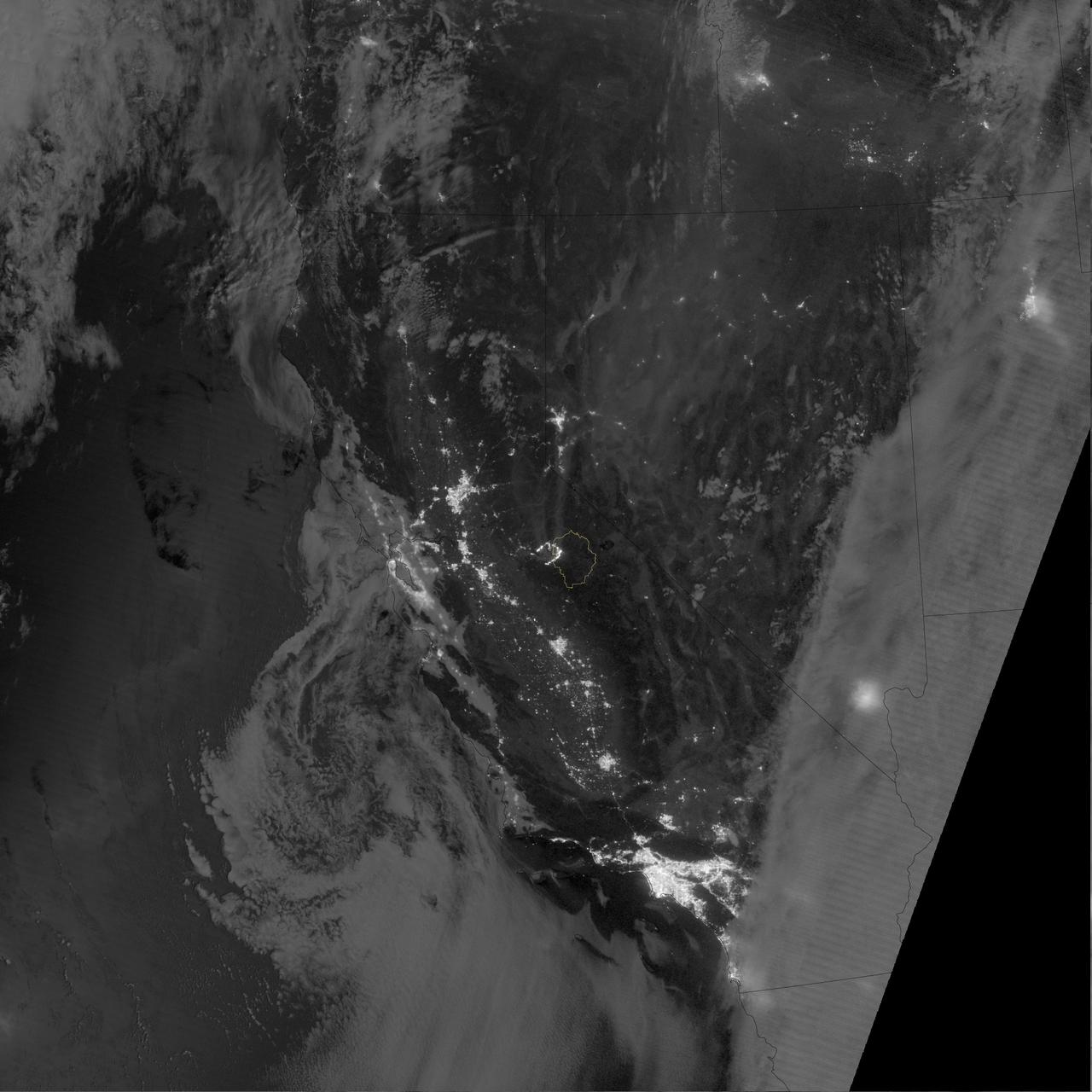
The winter of 2013 was among the driest on record for California, setting the stage for an active fire season. By August 26, the Rim Fire had made its way into the record books. At just 15 percent contained, the fire is now the 13th largest in California since records began in 1932. Apart from being large, the fire is also threatening one of the United States’ greatest natural treasures: Yosemite National Park. The Visible Infrared Imaging Radiometer Suite (VIIRS) on the Suomi NPP satellite tracked the growth of the fire between August 23 and August 26 in a series of nighttime images. The VIIRS day-night band is extremely sensitive to low light, making it possible to see the fire front from space. The brightest, most intense parts of the fire glow white, exceeding the brightness of the lights of Reno, Nevada to the north. Pale gray smoke streams north away from the fire throughout the sequence. The perimeter of the fire grows from day to day along different fronts, depending on winds and fire fighting efforts. On August 24, fire fighters focused their efforts on containing the western edge of the fire to prevent it from burning into Tuolumne City and the populated Highway 108 corridor. They also fought the eastern edge of the fire to protect Yosemite National Park. These efforts are evident in the image: Between August 23 and 24, the eastern edge of the fire held steady, and the western edge receded. The fire grew in the southeast. On the morning of August 25 fire managers reported that the fire was growing in the north and east. In the image, the most intense activity is just inside Yosemite National Park. Fire fighters reported that the Rim Fire continued to be extremely active on its eastern front on the morning of August 26, and this activity is visible in the image. By 8:00 a.m., the fire had burned 149,780 acres. The fire forced firefighters in Yosemite National Park to take measures to protect the Merced and Tuolumne Groves of Giant Sequoias, but the National Park Service reported that the trees were not in imminent danger. While parts of the park are closed, webcams show that most of the park has not been impacted. The Rim Fire started on the afternoon of August 17. It has destroyed 23 structures and threatened 4,500 other buildings. Its cause is under investigation. More details: <a href="http://1.usa.gov/18ilEAA" rel="nofollow">1.usa.gov/18ilEAA</a> NASA Earth Observatory image by Jesse Allen and Robert Simmon, using VIIRS Day Night Band data. Caption by Holli Riebeek. Instrument: Suomi NPP - VIIRS <b><a href="http://www.nasa.gov/audience/formedia/features/MP_Photo_Guidelines.html" rel="nofollow">NASA image use policy.</a></b> <b><a href="http://www.nasa.gov/centers/goddard/home/index.html" rel="nofollow">NASA Goddard Space Flight Center</a></b> enables NASA’s mission through four scientific endeavors: Earth Science, Heliophysics, Solar System Exploration, and Astrophysics. Goddard plays a leading role in NASA’s accomplishments by contributing compelling scientific knowledge to advance the Agency’s mission. <b>Follow us on <a href="http://twitter.com/NASA_GoddardPix" rel="nofollow">Twitter</a></b> <b>Like us on <a href="http://www.facebook.com/pages/Greenbelt-MD/NASA-Goddard/395013845897?ref=tsd" rel="nofollow">Facebook</a></b> <b>Find us on <a href="http://instagram.com/nasagoddard?vm=grid" rel="nofollow">Instagram</a></b>
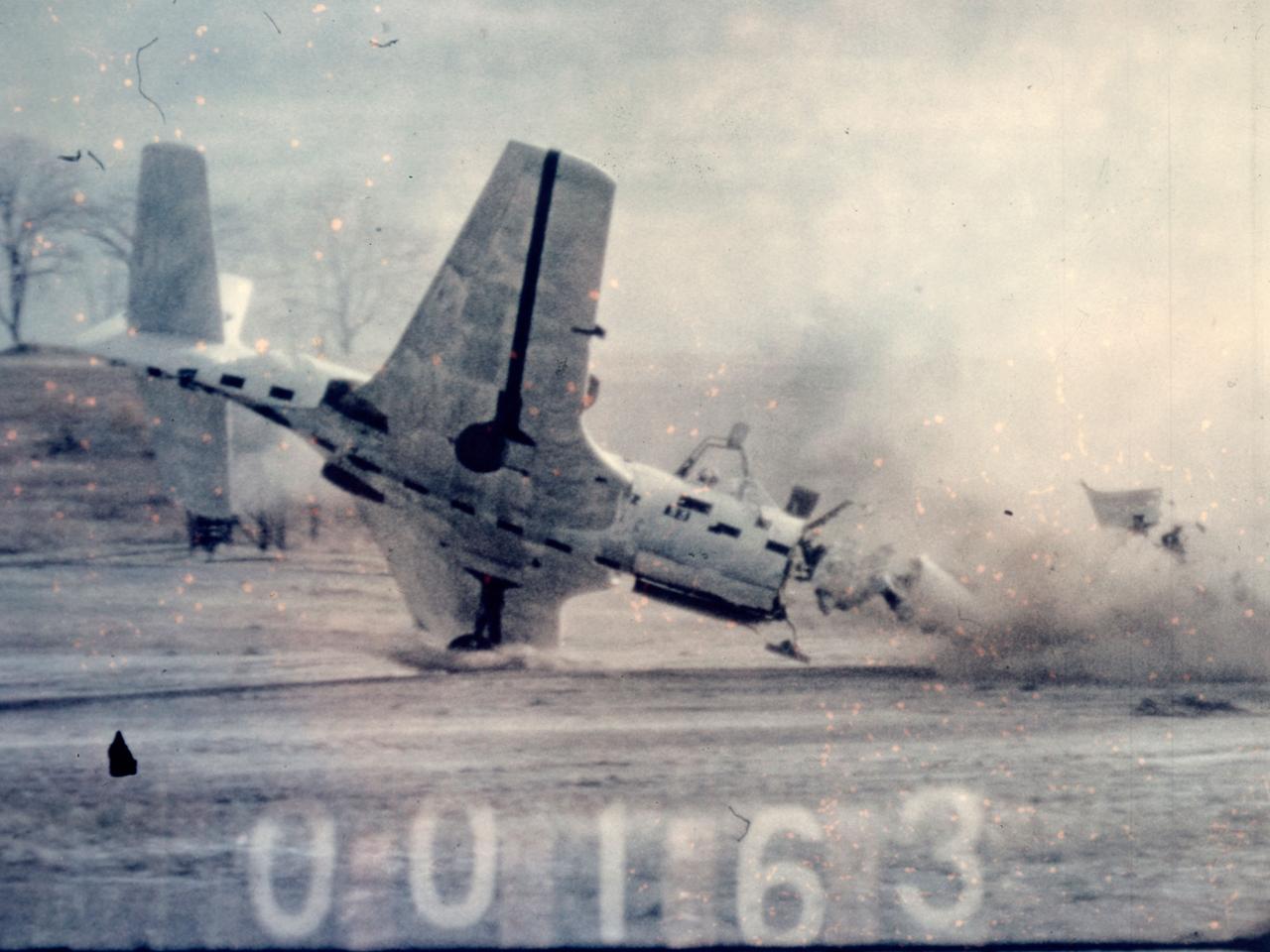
Researchers at the National Advisory Committee for Aeronautics (NACA) Lewis Flight Propulsion Laboratory purposely wreck a McDonnell FH-1 Phantom as part of the laboratory’s Crash Fire Program. NACA Lewis researchers created the program in 1949 to investigate methods for improving survival rates for take-off and landing-type crashes. In these types of crashes, the passengers often survived the impact only to perish in the ensuing fire. Previously there had been little information on the nature of post-crash fires, and it was difficult to use analytical studies in this area. Irving Pinkel, Chief of the Lewis Flight Propulsion Division, was the primary researcher. He enlisted flight safety specialist and aeronautics researchers G. Merritt Preston and Gerard Pesman, mechanical engineer Dugald Black, and others. The tests were conducted at the nearby Ravenna Arsenal using decommissioned Air Force fighter and transport aircraft. The pilotless aircraft were accelerated down a rail on a 1700-foot track at take-off speeds and run into barriers to simulate a variety of different types of crashes. The first barrier stripped off the landing gears and another briefly sent the aircraft off the ground before it crashed into a dirt mound. Telemetry and high-speed cameras were crucial elements in these studies. NACA Lewis photographer Bill Wynne developed a method for inserting timekeeping devices on test film that were able to show time to one thousandth of a second.
This frame from a video clip shows rockets fired by the test vehicle for NASA Low-Density Supersonic Decelerator project.
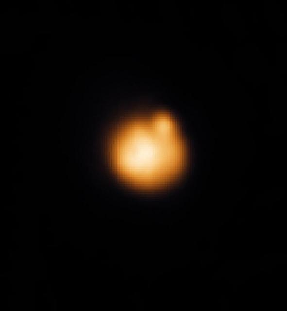
Earth-Based Observations of a Fire Fountain on Io

NASA Administrator Jim Bridenstine, left, and SpaceX Chief Engineer Elon Musk converse inside Firing Room 4 in Kennedy Space Center’s Launch Control Center while awaiting the liftoff of a SpaceX Falcon 9 rocket and Crew Dragon spacecraft on the uncrewed In-Flight Abort Test, Jan. 19, 2020. The test demonstrated the spacecraft’s escape capabilities in preparation for crewed flights to the International Space Station as part of the agency’s Commercial Crew Program.
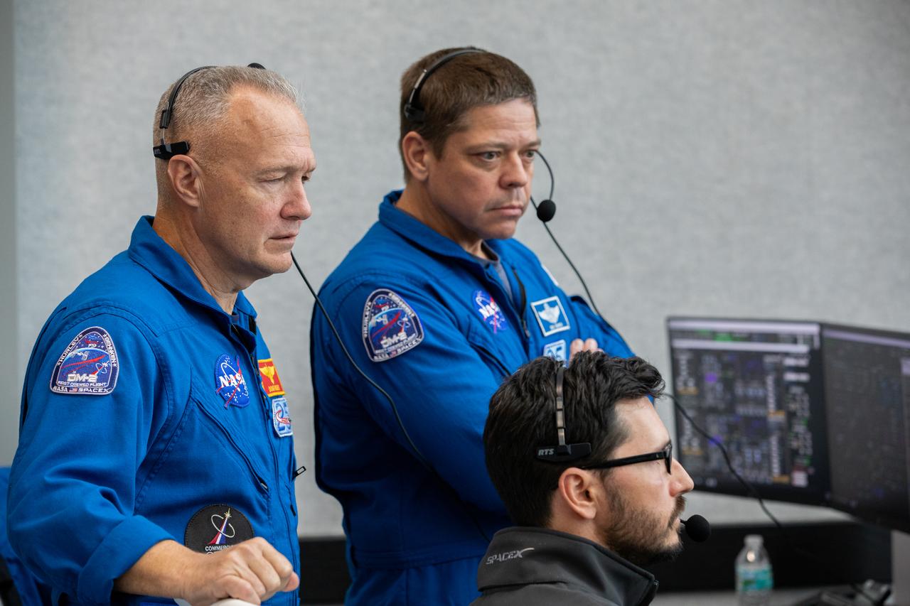
NASA astronauts Doug Hurley, left, and Bob Behnken watch the liftoff of a SpaceX Falcon 9 rocket and Crew Dragon spacecraft on the uncrewed In-Flight Abort Test, Jan. 19, 2020, inside Firing Room 4 in Kennedy Space Center’s Launch Control Center. The test demonstrated the spacecraft’s escape capabilities in preparation for crewed flights to the International Space Station as part of the agency’s Commercial Crew Program.
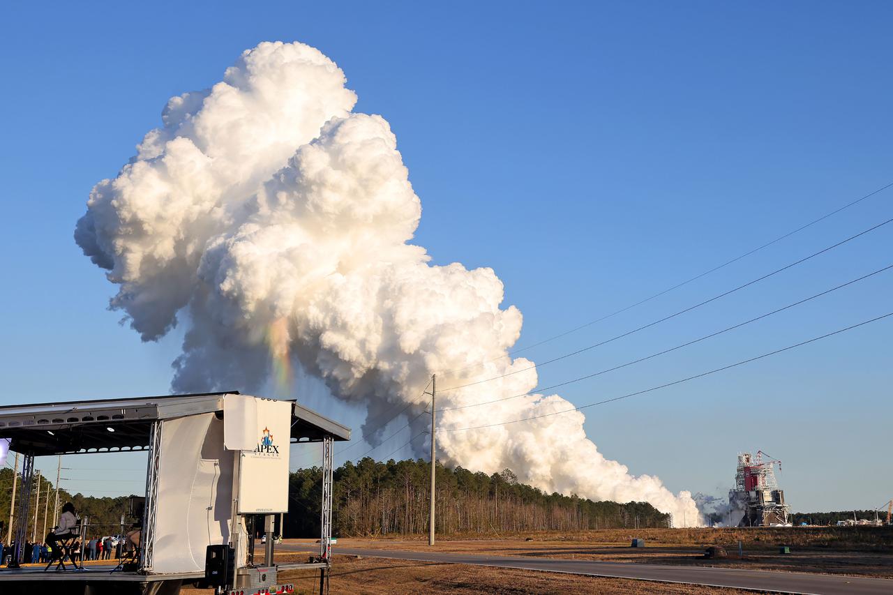
NASA conducts a hot fire test Jan. 16, 2021, of the core stage for the agency’s Space Launch System rocket on the B-2 Test Stand at Stennis Space Center near Bay St. Louis. The hot fire test of the stage’s four RS-25 engines generated a combined 1.6 million pounds of thrust, just as will occur during an actual launch. The hot fire is the final test of the Green Run test series, a comprehensive assessment of the SLS core stage prior to launching the Artemis I mission to the Moon.
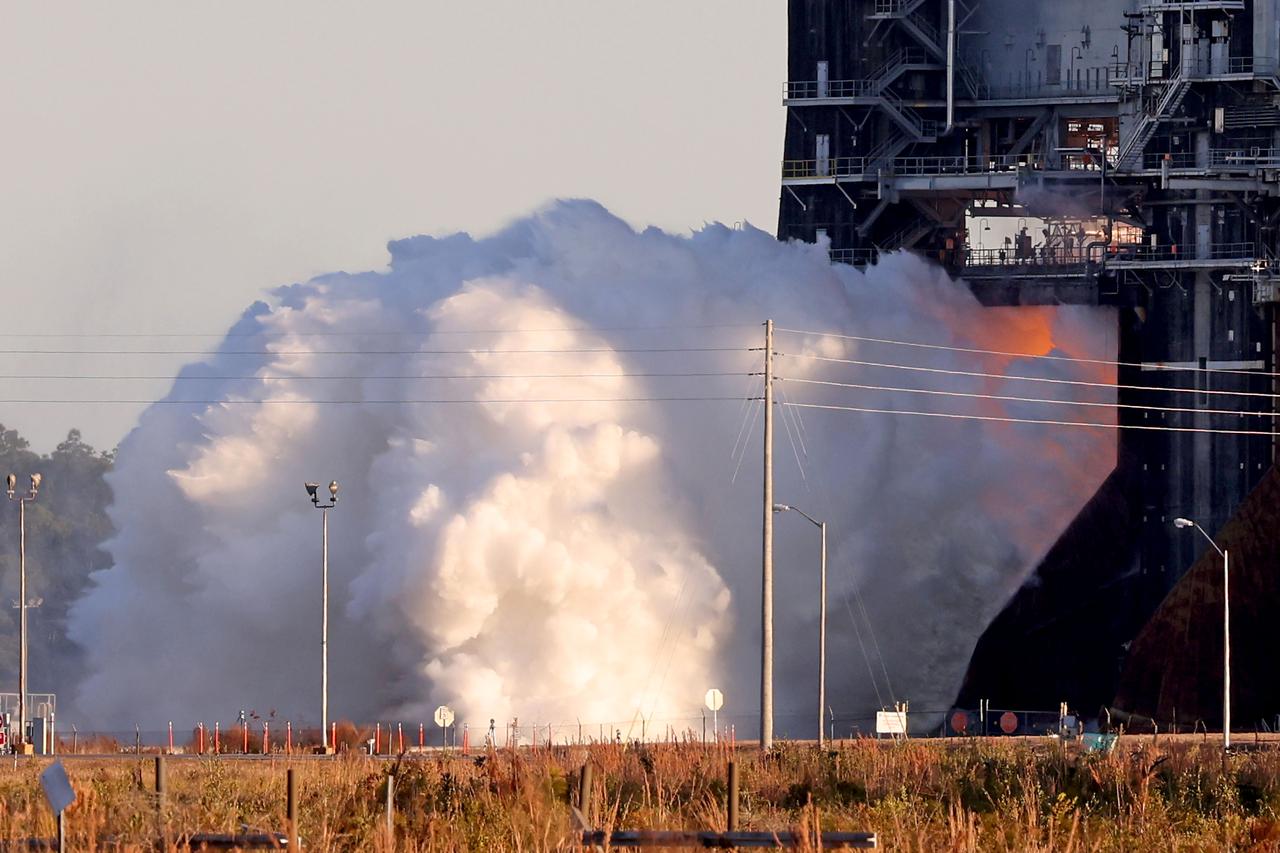
NASA conducts a hot fire test Jan. 16, 2021, of the core stage for the agency’s Space Launch System rocket on the B-2 Test Stand at Stennis Space Center near Bay St. Louis. The hot fire test of the stage’s four RS-25 engines generated a combined 1.6 million pounds of thrust, just as will occur during an actual launch. The hot fire is the final test of the Green Run test series, a comprehensive assessment of the SLS core stage prior to launching the Artemis I mission to the Moon.
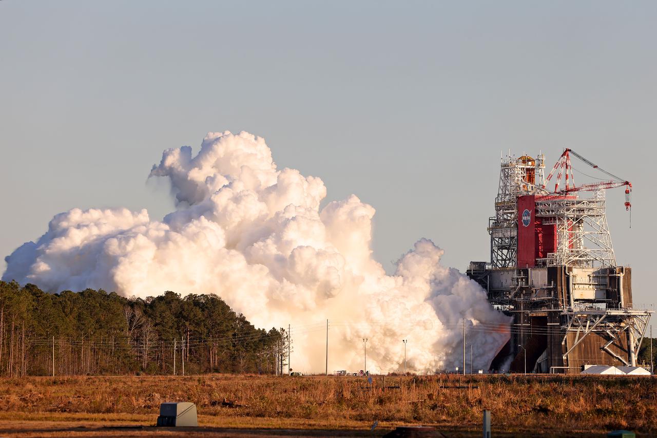
NASA conducts a hot fire test Jan. 16, 2021, of the core stage for the agency’s Space Launch System rocket on the B-2 Test Stand at Stennis Space Center near Bay St. Louis. The hot fire test of the stage’s four RS-25 engines generated a combined 1.6 million pounds of thrust, just as will occur during an actual launch. The hot fire is the final test of the Green Run test series, a comprehensive assessment of the SLS core stage prior to launching the Artemis I mission to the Moon.
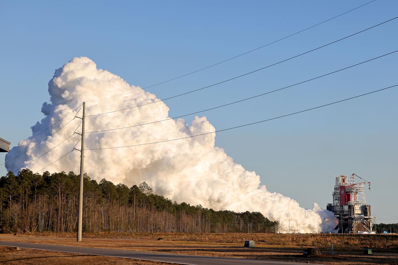
NASA conducts a hot fire test Jan. 16, 2021, of the core stage for the agency’s Space Launch System rocket on the B-2 Test Stand at Stennis Space Center near Bay St. Louis. The hot fire test of the stage’s four RS-25 engines generated a combined 1.6 million pounds of thrust, just as will occur during an actual launch. The hot fire is the final test of the Green Run test series, a comprehensive assessment of the SLS core stage prior to launching the Artemis I mission to the Moon.
Eight major wildfires burned through forests and grasslands in the Pacific Northwest in late-July 2013, threatening homes and forcing road closings and evacuations. Many parts of Washington and Oregon faced extreme fire threats, as strong thunderstorms lined up to hit parched forests and grasslands with lightning. On July 28, 2013, the Operational Land Imager (OLI) on Landsat 8 captured these images of the Mile Marker 28 fire in the Simcoe Mountains northeast of Goldendale, Washington. Smoke blew east toward Kennewick, Pasco, and Richland. The lower image shows a closer view of smoke billowing up from the most active part of the fire. Ignited on July 24, 2013, the fire charred more than 22,000 acres (8,900 hectares) by July 30, when more than 1,000 firefighters achieved 40 percent containment. The blaze forced the evacuation of dozens of homes and the closure of US Highway 97. Through July 25, 450 wildfires had burned 10,220 acres (4,136 hectares) in Washington, while Oregon saw 603 fires that burned 63,135 acres (25,549 hectares). In all, 2.3 million acres burned across the United States by late-July, below the national average. Over the past ten years, an average of 4.2 million acres had burned in the United States by the end of each July. While coastal and western Washington receive heavy rain throughout the year, the rain shadow caused by the Cascades leaves central Washington quite dry. The mountains force moist air from the Pacific to rise, causing it to cool and condense into rain or snow on the windward side of the Cascades. So little moisture is left by the time air passes over the Cascades, that the area around Mile Marker 28 typically receives just 8 inches (20 centimeters) of precipitation per year. NASA Earth Observatory image by Jesse Allen and Robert Simmon, using Landsat data from the U.S. Geological Survey. Caption by Adam Voiland Instrument: Landsat 8 - OLI More info: <a href="http://earthobservatory.nasa.gov/IOTD/view.php?id=81738" rel="nofollow">earthobservatory.nasa.gov/IOTD/view.php?id=81738</a> Credit: <b><a href="http://www.earthobservatory.nasa.gov/" rel="nofollow"> NASA Earth Observatory</a></b> <b><a href="http://www.nasa.gov/audience/formedia/features/MP_Photo_Guidelines.html" rel="nofollow">NASA image use policy.</a></b> <b><a href="http://www.nasa.gov/centers/goddard/home/index.html" rel="nofollow">NASA Goddard Space Flight Center</a></b> enables NASA’s mission through four scientific endeavors: Earth Science, Heliophysics, Solar System Exploration, and Astrophysics. Goddard plays a leading role in NASA’s accomplishments by contributing compelling scientific knowledge to advance the Agency’s mission. <b>Follow us on <a href="http://twitter.com/NASA_GoddardPix" rel="nofollow">Twitter</a></b> <b>Like us on <a href="http://www.facebook.com/pages/Greenbelt-MD/NASA-Goddard/395013845897?ref=tsd" rel="nofollow">Facebook</a></b> <b>Find us on <a href="http://instagram.com/nasagoddard?vm=grid" rel="nofollow">Instagram</a></b>

iss071e666237 (Sept. 17, 2024) --- NASA astronaut Don Pettit was able to capture a photo of a recent fire in La Porte, Texas yesterday. Our NASA Astronauts have the ability to observe natural disasters from a vantage point of 250 miles above Earth. The imagery and data provided from the International Space Station can provide benefits to regions that experience unexpected events such as fires, floods, hurricanes, earthquakes, and more. This information is valuable when monitoring disasters on Earth in real time.

NASA astronaut Don Pettit was able to capture a photo of a recent fire in La Porte, Texas yesterday. Our NASA Astronauts have the ability to observe natural disasters from a vantage point of 250 miles above Earth. The imagery and data provided from the International Space Station can provide benefits to regions that experience unexpected events such as fires, floods, hurricanes, earthquakes, and more. This information is valuable when monitoring disasters on Earth in real time.

iss071e666253 (Sept. 17, 2024) --- NASA astronaut Don Pettit was able to capture a photo of a recent fire in La Porte, Texas yesterday. Our NASA Astronauts have the ability to observe natural disasters from a vantage point of 250 miles above Earth. The imagery and data provided from the International Space Station can provide benefits to regions that experience unexpected events such as fires, floods, hurricanes, earthquakes, and more. This information is valuable when monitoring disasters on Earth in real time.
The fire season in California has been anything but cooperative this year. Hot conditions combined with a state-wide drought and dry lightning makes for unpleasant conditions and leads to an abundance of forest fires. On August 12, lightning struck and started the fire that grew into the Happy Camp Complex. Currently over 113,000 acres have been affected and the fire is only 55% contained as of today. Strong winds tested fire lines yesterday (8/15), and are expected to do so again today. Despite the high winds, existing fire lines held with no spotting or expansion outside current containment lines. The south end of the fire continued backing slowly toward Elk Creek in the Marble Mountain Wilderness. The Man Fire joined with the Happy Camp Complex yesterday and will be managed by California Interagency Incident Management Team 4 as of 6:00am on Wednesday, September 17, 2014. Nearby the Happy Camp Complex, near Mt. Shasta and the town of Weed, another fire erupted that fire officials said quickly damaged or destroyed 100 structures Monday (8/15). Hundreds of firefighters were trying to contain that fire. A California Fire spokesman said more than 300 acres were scorched and more than 100 structures damaged or destroyed in just a few hours. The blaze, dubbed the Boles Fire, also led to the closure of Interstate 5 and U.S. 97. Weed is in Siskiyou County, about 50 miles south of the California-Oregon border. With strong winds, the fire was able to rage into the community before firefighters could get equipment to the blaze. About 1,500 to 2,000 residents were being evacuated to the Siskiyou County fairgrounds. An evacuation center was set up at the county fairgrounds in Yreka. NASA's Aqua satellite collected this natural-color image with the Moderate Resolution Imaging Spectroradiometer, MODIS, instrument on September 15, 2014. Actively burning areas, detected by MODIS’s thermal bands, are outlined in red. NASA image courtesy Jeff Schmaltz LANCE/EOSDIS MODIS Rapid Response Team, GSFC. Caption by Lynn Jenner with information from Inciweb and California Department of Forestry and Fire Protection. <b><a href="http://www.nasa.gov/audience/formedia/features/MP_Photo_Guidelines.html" rel="nofollow">NASA image use policy.</a></b> <b><a href="http://www.nasa.gov/centers/goddard/home/index.html" rel="nofollow">NASA Goddard Space Flight Center</a></b> enables NASA’s mission through four scientific endeavors: Earth Science, Heliophysics, Solar System Exploration, and Astrophysics. Goddard plays a leading role in NASA’s accomplishments by contributing compelling scientific knowledge to advance the Agency’s mission. <b>Follow us on <a href="http://twitter.com/NASAGoddardPix" rel="nofollow">Twitter</a></b> <b>Like us on <a href="http://www.facebook.com/pages/Greenbelt-MD/NASA-Goddard/395013845897?ref=tsd" rel="nofollow">Facebook</a></b> <b>Find us on <a href="http://instagram.com/nasagoddard?vm=grid" rel="nofollow">Instagram</a></b>
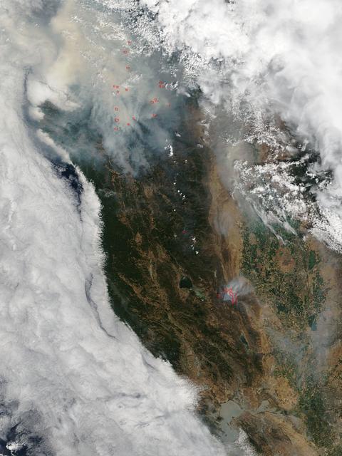
This satellite image shows smoke from several fires in Oregon and California on Aug. 2, 2015. The Moderate Resolution Imaging Spectroradiometer (MODIS) instrument that flies aboard NASA's Aqua satellite captured an image of smoke from these fires Aug. 2 at 21:05 UTC (5:05 p.m. EDT). The multiple red pixels are heat signatures detected by MODIS. The smoke appears to be a light brown color. InciWeb is an interagency all-risk incident information management system that coordinates with federal, state and local agencies to manage wildfires. In Oregon smoke from the Cable Crossing Fire, the Stouts Fire and the Potter Mountain Complex Fire commingle. The Cable Crossing Fire was reported burning on forestlands protected by the Douglas Forest Protective Association (DFPA) at approximately 3:25 p.m. on Tuesday, July 28, 2015, near Oregon Highway 138 East, near Mile Post 23, east of Glide. South of the Cable Crossing Fire is the Stouts Fire also in forestlands of the DFPA. This fire was reported on Thursday, July 30, 2015, burning approximately 11 miles east of Canyonville near the community of Milo. East of the other fires is the Potter Mountain Complex Fire. These fires are located in the Deschutes Forest consists of eight fires. According to Inciweb they were started by dry lightning on Saturday, Aug. 2, at approximately 5:30 p.m. about five miles north of Toketee Lake. In northern California, smoke from the River Complex Fire, the Fork Complex Fire and the Shf July Lightning Fire was visible in the MODIS image. The River Complex currently consists of seven reported and observed fires on the Six Rivers and Shasta Trinity National Forests. Originally identified as 18 fires, some have burned together. Inciweb noted that in the Six Rivers National Forest there are fires in the Trinity Alps Wilderness. Those fires include the Groves Fire and the Elk Fire. In the Shasta-Trinity National Forest the fires include the Happy Fire at 2,256 acres, Daily Fire at 16 acres, the Look Fire at 7 acres, Onion Fire at 136 acres and Smokey Fire at 1 acre. In the same forest, south of the River Complex is the Fork Complex fire. Inciweb reported that the Fork Complex consists of (at current count) over 40 fires, all of which were ignited by lightning between July 29 and 31, 2015. To the southwest of this complex is the Mad River Complex. This is a series of seven lightning fires that started on July 30, 2015 after a lightning storm moved through Northern California. To the east of this and the other fires, burns another near Redding, California, called the Shf July Lightning Fire. This is also under the Shasta-Trinity National Forest management. At 8 p.m. PDT on Aug. 2, Inciweb reported that approximately 15 lightning strikes occurred within 24 hours throughout the Shasta Trinity National Forest and resulted in two new fires. The Caves fire, east of Mt. Shasta, is approximately one-tenth of an acre. The Bluejay fire, east of Shasta Lake, is approximately four acres. Image credit: NASA Goddard's MODIS Rapid Response Team, Jeff Schmaltz <b><a href="http://www.nasa.gov/audience/formedia/features/MP_Photo_Guidelines.html" rel="nofollow">NASA image use policy.</a></b> <b><a href="http://www.nasa.gov/centers/goddard/home/index.html" rel="nofollow">NASA Goddard Space Flight Center</a></b> enables NASA’s mission through four scientific endeavors: Earth Science, Heliophysics, Solar System Exploration, and Astrophysics. Goddard plays a leading role in NASA’s accomplishments by contributing compelling scientific knowledge to advance the Agency’s mission. <b>Follow us on <a href="http://twitter.com/NASAGoddardPix" rel="nofollow">Twitter</a></b> <b>Like us on <a href="http://www.facebook.com/pages/Greenbelt-MD/NASA-Goddard/395013845897?ref=tsd" rel="nofollow">Facebook</a></b> <b>Find us on <a href="http://instagrid.me/nasagoddard/?vm=grid" rel="nofollow">Instagram</a></b>
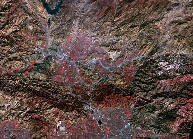
While the Thomas fire in Ventura County, CA is the largest and most destructive, several other smaller fires burned in the Los Angeles area. The Creek fire destroyed 123 buildings and consumed over 15,000 acres. The smaller Rye fire burned 6,000 acres and destroyed 9 structures. The image was acquired December 17, 2017, covers an area of 9.7 by 13.5 kilometers, and is located at 34.4 degrees north, 118.5 degrees west. https://photojournal.jpl.nasa.gov/catalog/PIA22149
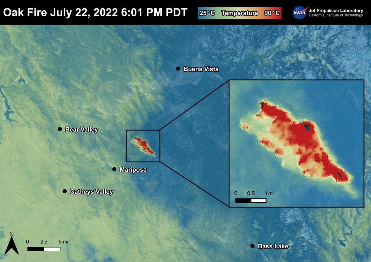
The Oak Fire started on July 22nd, 2022 at 2:10 PM PDT near Carstens Road and Highway 140 in Mariposa County, west of Yosemite. The fire has burned over 19,000 acres. In the first few days of the Oak Fire, over 1,400 structures were threatened, 3 were damaged, and 41 destroyed. Evacuation orders and road closures were issued throughout the region. The Oak Fire was captured in an ECOSTRESS Land Surface Temperature image on July 22nd with temperatures exceeding 90 degrees Celsius. ECOSTRESS is a thermal instrument on the International Space Station that measures the temperature of the ground, which is hotter than the air temperature during the day. It was launched to the space station in 2018. Its primary mission is to identify critical thresholds of water use and water stress in plants and to detect the timing, location, and predictive factors leading to plant water uptake decline and/or cessation. The nature of the high-resolution data provided by ECOSTRESS allows it to record heat related phenomena such as heat waves and wildfires. https://photojournal.jpl.nasa.gov/catalog/PIA25481
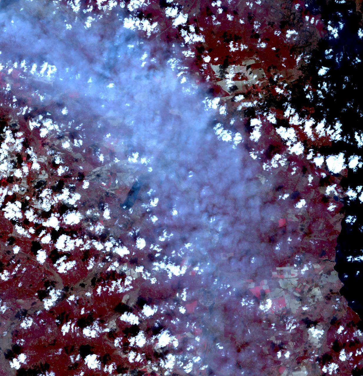
Fires began near the Chernobyl Nuclear Power Plant in Ukraine April 4, 2020. By April 14, the fires were nearly extinguished. On April 16, new fires erupted, sending large, dark gray clouds of smoke traveling over 750 km to the southeast. The ASTER image, acquired April 18, shows part of the billowing smoke plume. The image covers an area of 59.2 by 61.4 km, and is located near 51 degrees north, 30.1 degrees east. https://photojournal.jpl.nasa.gov/catalog/PIA23911
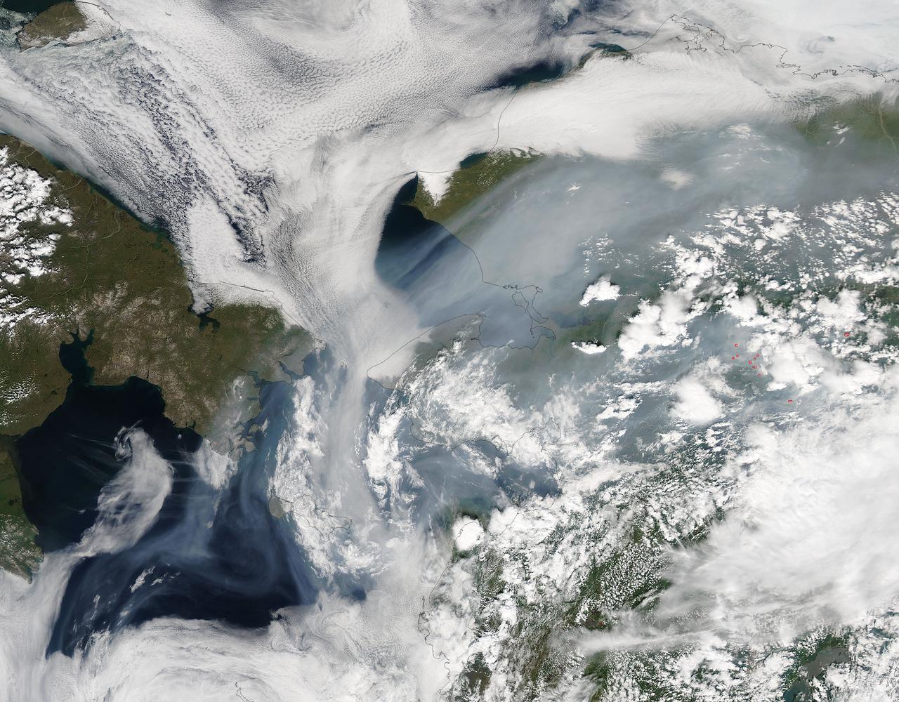
Fires have raged throughout Alaska in 2015. The Moderate Resolution Imaging Spectroradiometer (MODIS) on NASA’s Aqua satellite acquired this image on July 14, 2015. Actively burning areas, detected by the thermal bands on MODIS, are outlined in red. According to the most recent update (July 16, 2015) from the Alaska Interagency Coordination Center, about 304 fires were actively burning when MODIS imaged the area. To date, fires have charred a total of 4,854,924 acres in Alaska. The worst fire season in Alaska's history was in 2004. At this point in time, 2015 is a month ahead of the totals in 2004 putting it on track surpass the fire totals in 2004. The amount of acreage burned in Alaska during June 2015 shattered the previous acreage record set in June 2004 by more than 700,000 acres delivering a sobering piece of news for Alaskan residents. Credit: NASA/GSFC/Jeff Schmaltz/MODIS Land Rapid Response Team <b><a href="http://www.nasa.gov/audience/formedia/features/MP_Photo_Guidelines.html" rel="nofollow">NASA image use policy.</a></b> <b><a href="http://www.nasa.gov/centers/goddard/home/index.html" rel="nofollow">NASA Goddard Space Flight Center</a></b> enables NASA’s mission through four scientific endeavors: Earth Science, Heliophysics, Solar System Exploration, and Astrophysics. Goddard plays a leading role in NASA’s accomplishments by contributing compelling scientific knowledge to advance the Agency’s mission. <b>Follow us on <a href="http://twitter.com/NASAGoddardPix" rel="nofollow">Twitter</a></b> <b>Like us on <a href="http://www.facebook.com/pages/Greenbelt-MD/NASA-Goddard/395013845897?ref=tsd" rel="nofollow">Facebook</a></b> <b>Find us on <a href="http://instagrid.me/nasagoddard/?vm=grid" rel="nofollow">Instagram</a></b>
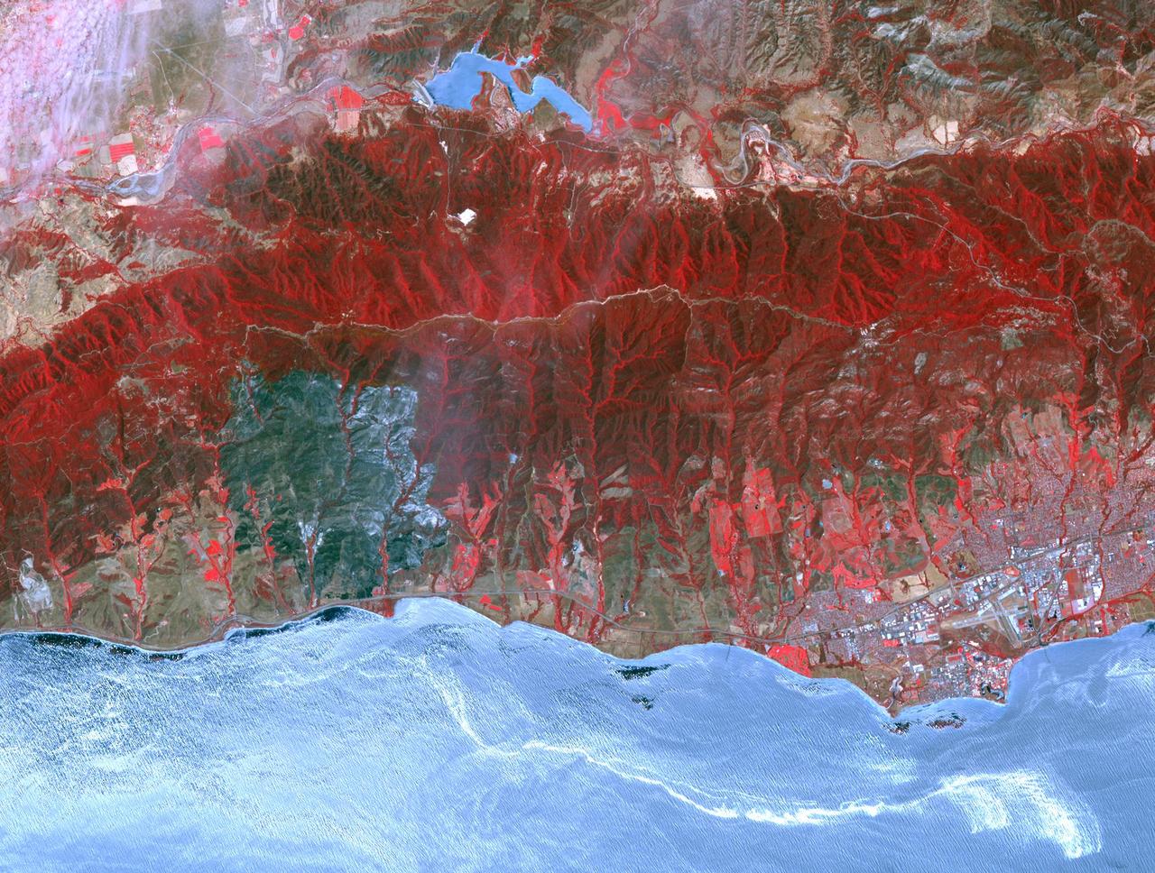
The Sherpa fire in Santa Barbara County, CA has burned over 12 square miles since it started on June 15. Smoke from the fire reached Los Angeles on the weekend. The fire caused closures of US Highway 101, one of the main routes between southern and northern California. The image was acquired June 19, 2016, covers an area of 25 by 30 kilometers, and is located at 34.4 degrees north, 119.8 degrees west. http://photojournal.jpl.nasa.gov/catalog/PIA20734
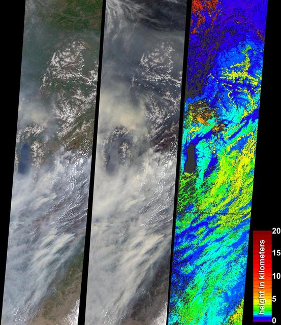
During the 2003 fire season, blazes in the taiga forests of Eastern Siberia were part of a vast network of fires across Siberia and the Russian Far East, northeast China and northern Mongolia seen here by NASA Terra spacecraft.
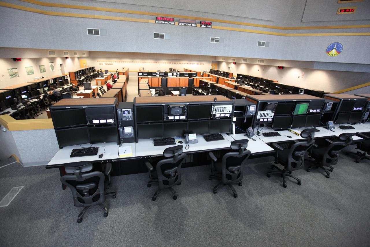
Photos of Firing Room 1 inside the Launch Control Center (LCC) at Kennedy Space Center.
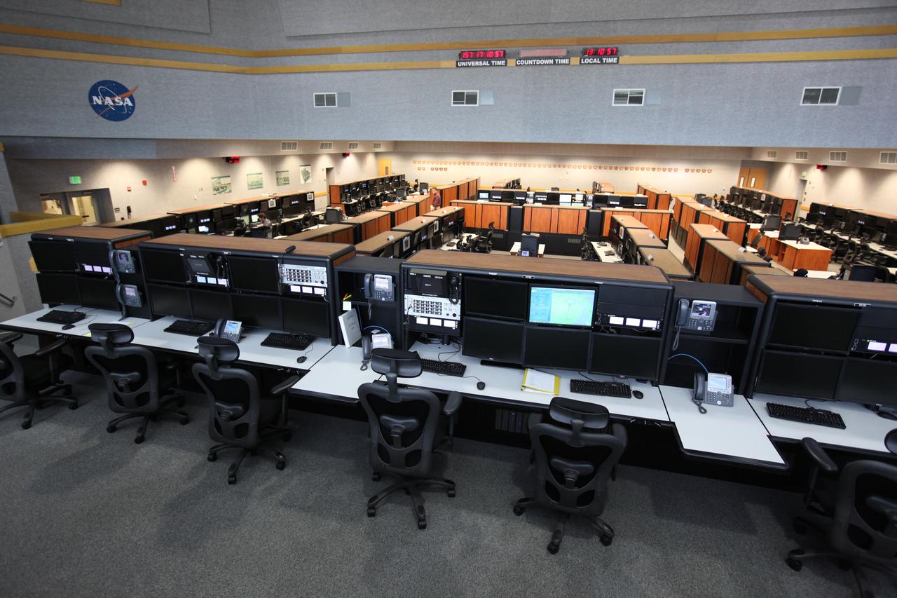
Photos of Firing Room 1 inside the Launch Control Center (LCC) at Kennedy Space Center.
Photos of Firing Room 1 inside the Launch Control Center (LCC) at Kennedy Space Center.
Photos of Firing Room 1 inside the Launch Control Center (LCC) at Kennedy Space Center.

As firefighters continue to work toward full containment of the rash of wildfires burning in Northern California, a new image from the Advanced Spaceborne Thermal Emission and Reflection Radiometer (ASTER) instrument on NASA's Terra satellite shows the growing fire scar on the landscape. In this ASTER image, acquired Oct. 21, 2017, vegetation is red, while burned areas appear dark gray. The image covers an area of 38 by 39 miles (60.5 by 63 kilometers) and is located near 38.5 degrees north, 122.4 degrees west. https://photojournal.jpl.nasa.gov/catalog/PIA22049
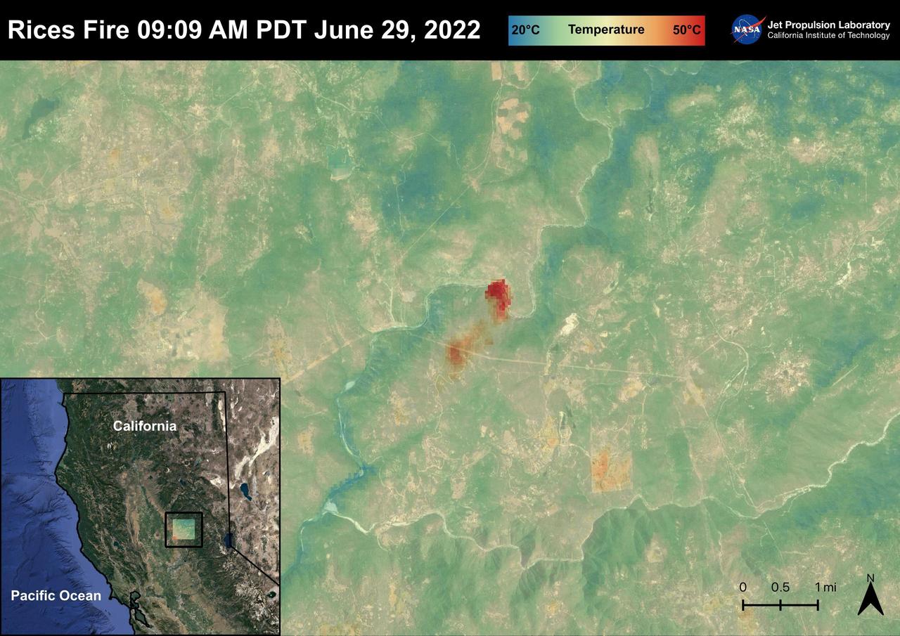
The Rices Fire started on June 28th, 2022 in Northern California near the Yuba River in Nevada County. The fire has burned over 900 acres and has destroyed one structure. French Corral, Birchville, and other communities were evacuated, but orders have since been lifted. There have been some firefighter injuries reported, but not casualties. The fire was captured in an ECOSTRESS Land Surface image on June 29 at 09:09 AM PDT and shows the temperatures surpassing 130 degrees Fahrenheit. ECOSTRESS is a thermal instrument on the International Space Station that measures the temperature of the ground, which is hotter than the air temperature during the day. It was launched to the space station in 2018. Its primary mission is to identify critical thresholds of water use and water stress in plants and to detect the timing, location, and predictive factors leading to plant water uptake decline and/or cessation. The nature of the high-resolution data provided by ECOSTRESS allows it to record heat related phenomena such as heat waves and wildfires. https://photojournal.jpl.nasa.gov/catalog/PIA25485