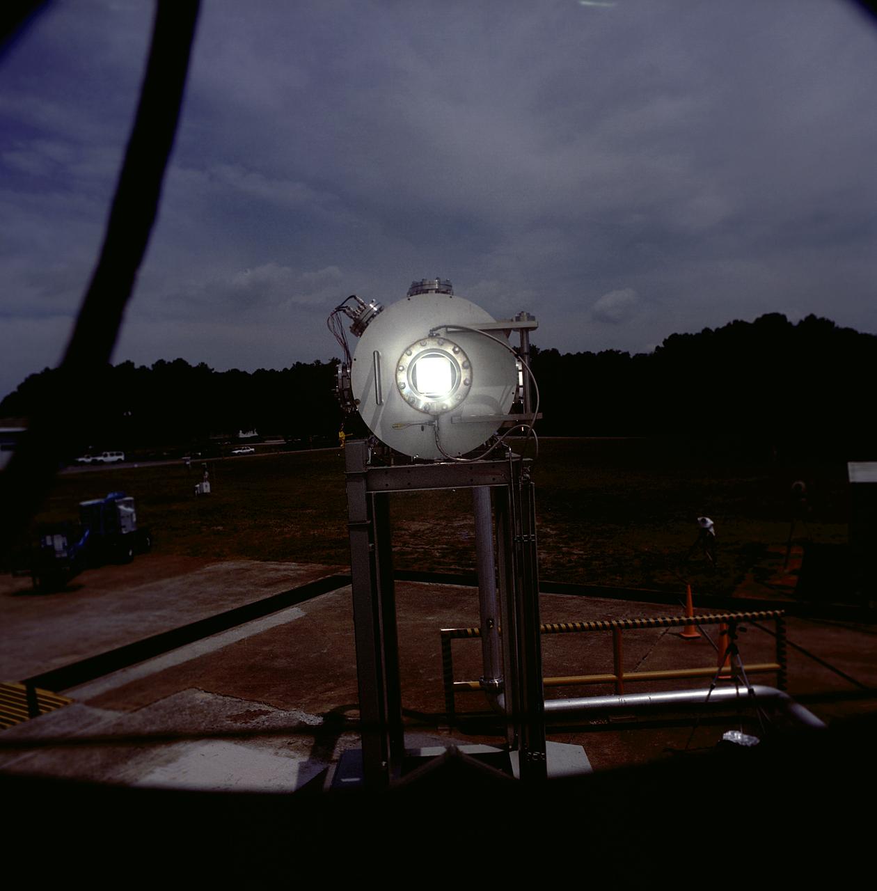
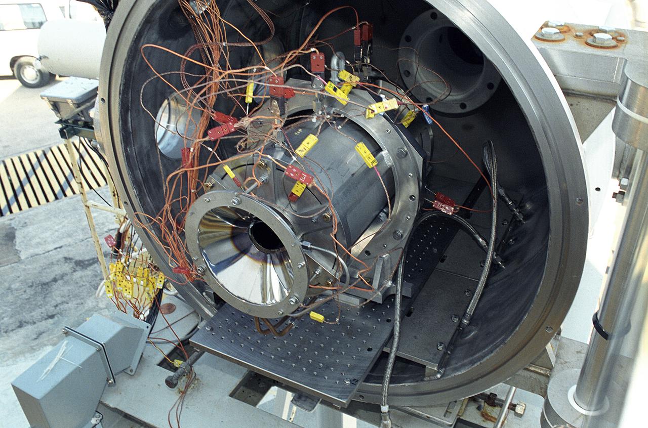
Researchers at the Marshall Space Flight Center (MSFC) have designed, fabricated, and tested the first solar thermal engine, a non-chemical rocket engine that produces lower thrust but has better thrust efficiency than a chemical combustion engine. MSFC turned to solar thermal propulsion in the early 1990s due to its simplicity, safety, low cost, and commonality with other propulsion systems. Solar thermal propulsion works by acquiring and redirecting solar energy to heat a propellant. The 20- by 24-ft heliostat mirror (not shown in this photograph) has dual-axis control that keeps a reflection of the sunlight on an 18-ft diameter concentrator mirror, which then focuses the sunlight to a 4-in focal point inside the vacuum chamber. The focal point has 10 kilowatts of intense solar power. This photograph is a close-up view of a 4-in focal point inside the vacuum chamber at the MSFC Solar Thermal Propulsion Test facility. As part of MSFC's Space Transportation Directorate, the Propulsion Research Center serves as a national resource for research of advanced, revolutionary propulsion technologies. The mission is to move the Nation's capabilities beyond the confines of conventional chemical propulsion into an era of aircraft-like access to Earth orbit, rapid travel throughout the solar system, and exploration of interstellar space.

This image acquired by NASA Terra spacecraft is of the Sierra Leone estuary, which became a focal point for trade and interaction between Africans and Europeans because of its exceptional harbor, starting in the mid-15th century.
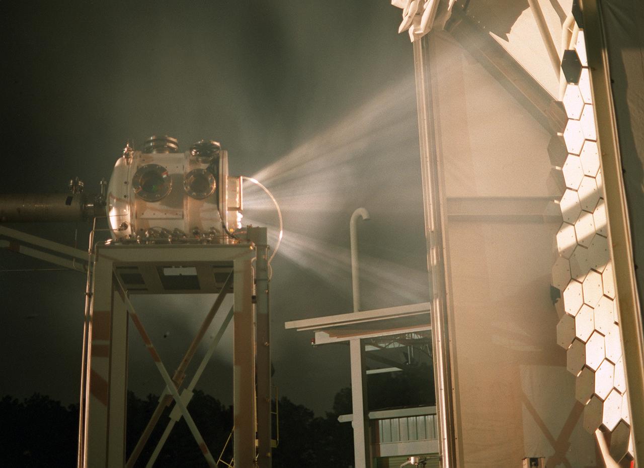
Researchers at the Marshall Space Flight Center (MSFC) have designed, fabricated, and tested the first solar thermal engine, a non-chemical rocket engine that produces lower thrust but has better thrust efficiency than a chemical combustion engine. MSFC turned to solar thermal propulsion in the early 1990s due to its simplicity, safety, low cost, and commonality with other propulsion systems. Solar thermal propulsion works by acquiring and redirecting solar energy to heat a propellant. The 20- by 24-ft heliostat mirror (not shown in this photograph) has a dual-axis control that keeps a reflection of the sunlight on the 18-ft diameter concentrator mirror, which then focuses the sunlight to a 4-in focal point inside the vacuum chamber. The focal point has 10 kilowatts of intense solar power. This image, taken during the test, depicts the light being concentrated into the focal point inside the vacuum chamber. As part of MSFC's Space Transportation Directorate, the Propulsion Research Center serves as a national resource for research of advanced, revolutionary propulsion technologies. The mission is to move the Nation's capabilities beyond the confines of conventional chemical propulsion into an era of aircraft-like access to Earth orbit, rapid travel throughout the solar system, and exploration of interstellar space.
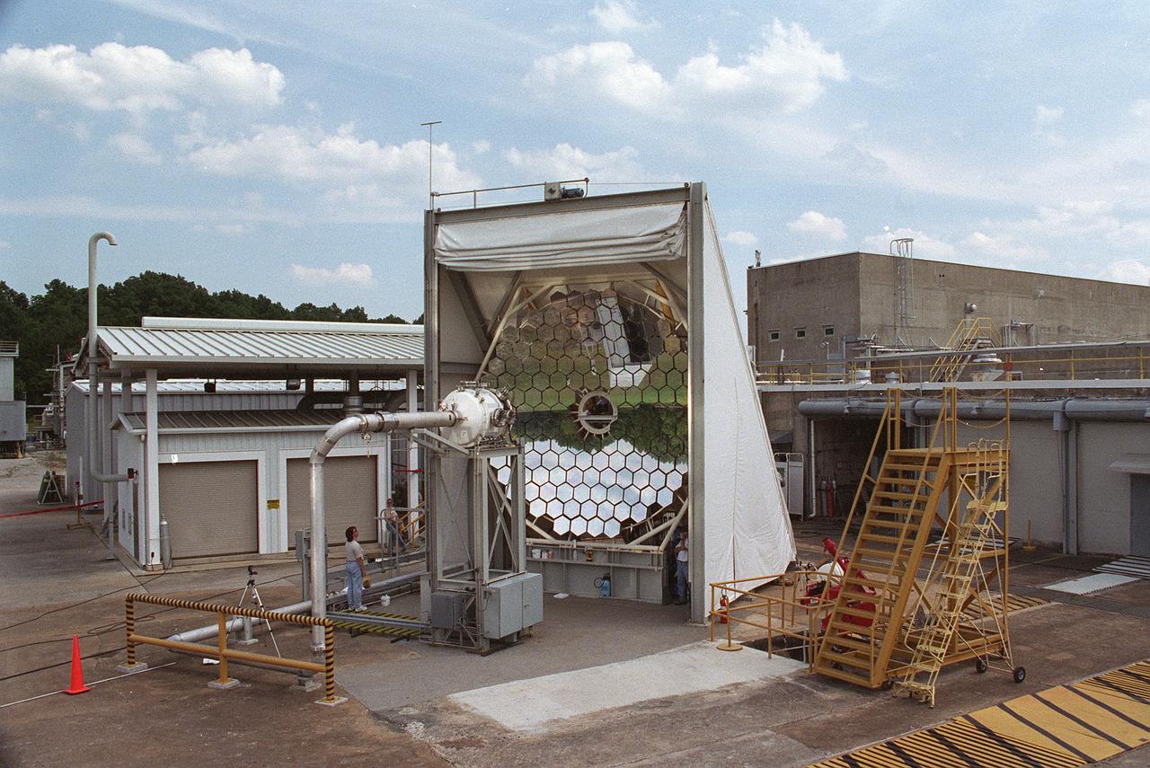
Researchers at the Marshall Space Flight Center (MSFC) have designed, fabricated and tested the first solar thermal engine, a non-chemical rocket engine that produces lower thrust but has better thrust efficiency than a chemical combustion engine. MSFC turned to solar thermal propulsion in the early 1990s due to its simplicity, safety, low cost, and commonality with other propulsion systems. Solar thermal propulsion works by acquiring and redirecting solar energy to heat a propellant. This photograph, taken at MSFC's Solar Thermal Propulsion Test Facility, shows a concentrator mirror, a combination of 144 mirrors forming this 18-ft diameter concentrator, and a vacuum chamber that houses the focal point. The 20- by 24-ft heliostat mirror (not shown in this photograph) has a dual-axis control that keeps a reflection of the sunlight on the 18-foot diameter concentrator mirror, which then focuses the sunlight to a 4-in focal point inside the vacuum chamber. The focal point has 10 kilowatts of intense solar power. As part of MSFC's Space Transportation Directorate, the Propulsion Research Center serves as a national resource for research of advanced, revolutionary propulsion technologies. The mission is to move the Nation's capabilities beyond the confines of conventional chemical propulsion into an era of aircraft-like access to Earth-orbit, rapid travel throughout the solar system, and exploration of interstellar space.
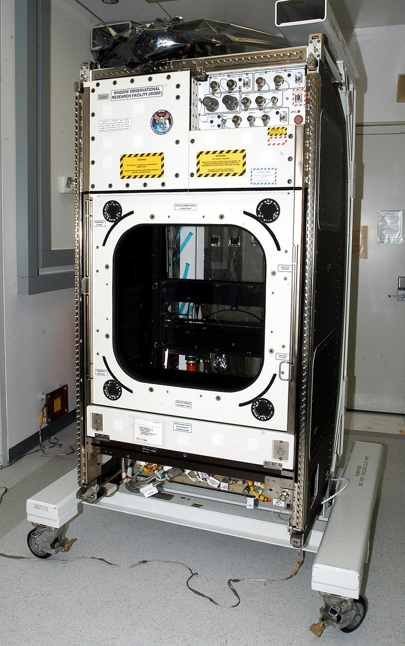
KENNEDY SPACE CENTER, FLA. - The Window Observational Research Facility (WORF), seen in the Space Station Processing Facility, was designed and built by the Boeing Co. at NASA’s Marshall Space Flight Center in Huntsville, Ala. WORF will be delivered to the International Space Station and placed in the rack position in front of the Destiny lab window, providing locations for attaching cameras, multi-spectral scanners and other instruments. WORF will support a variety of scientific and commercial experiments in areas of Earth systems and processes, global ecological changes in Earth’s biosphere, lithosphere, hydrosphere and climate system, Earth resources, natural hazards, and education. After installation, it will become a permanent focal point for Earth Science research aboard the space station.
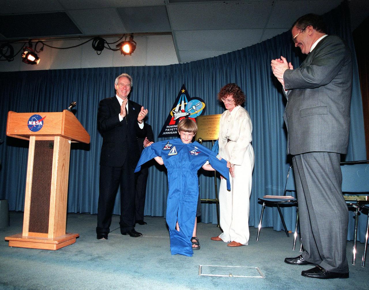
A ceremony dedicated the KSC Press Site auditorium as the John Holliman Auditorium to honor the correspondent for his enthusiastic, dedicated coverage of America's space program. The auditorium was built in 1980 and has been the focal point for news coverage of Space Shuttle launches. The ceremony followed the 94th launch of a Space Shuttle, on mission STS-96, earlier this morning

ISS040-E-108386 (25 Aug. 2014) --- One of the Expedition 40 crew members aboard the Earth-orbiting International Space Station photographed this image of a large part of New York City on Aug. 25, 2014. Manhattan Island and its Central Park are tell-tale points for recognition purposes for the six-person crew of the orbital outpost, flying approximately 225 nautical miles above the city. The 800mm focal length used by the crew member provides great detail in the scene.

ISS040-E-108372 (25 Aug. 2014) --- One of the Expedition 40 crew members aboard the Earth-orbiting International Space Station photographed this image of a large part of New York City on Aug. 25, 2014. Manhattan Island and its Central Park are tell-tale points for recognition purposes for the six-person crew of the orbital outpost, flying approximately 225 nautical miles above the city. The 800mm focal length used by the crew member provides great detail in the scene.

ISS040-E-108374 (25 Aug. 2014) --- One of the Expedition 40 crew members aboard the Earth-orbiting International Space Station photographed this image of a large part of New York City on Aug. 25, 2014. Manhattan Island and its Central Park are tell-tale points for recognition purposes for the six-person crew of the orbital outpost, flying approximately 225 nautical miles above the city. The 800mm focal length used by the crew member provides great detail in the scene.
Researchers at the Marshall Space Flight Center (MSFC) have designed, fabricated, and tested the first solar thermal engine, a non-chemical rocket engine that produces lower thrust but has better thrust efficiency than a chemical combustion engine. MSFC turned to solar thermal propulsion in the early 1990s due to its simplicity, safety, low cost, and commonality with other propulsion systems. Solar thermal propulsion works by acquiring and redirecting solar energy to heat a propellant. This photograph shows a fully assembled solar thermal engine placed inside the vacuum chamber at the test facility prior to testing. The 20- by 24-ft heliostat mirror (not shown in this photograph) has a dual-axis control that keeps a reflection of the sunlight on the 18-ft diameter concentrator mirror, which then focuses the sunlight to a 4-in focal point inside the vacuum chamber. The focal point has 10 kilowatts of intense solar power. As part of MSFC's Space Transportation Directorate, the Propulsion Research Center serves as a national resource for research of advanced, revolutionary propulsion technologies. The mission is to move theNation's capabilities beyond the confines of conventional chemical propulsion into an era of aircraft-like access to Earth orbit, rapid travel throughout the solar system, and exploration of interstellar space.
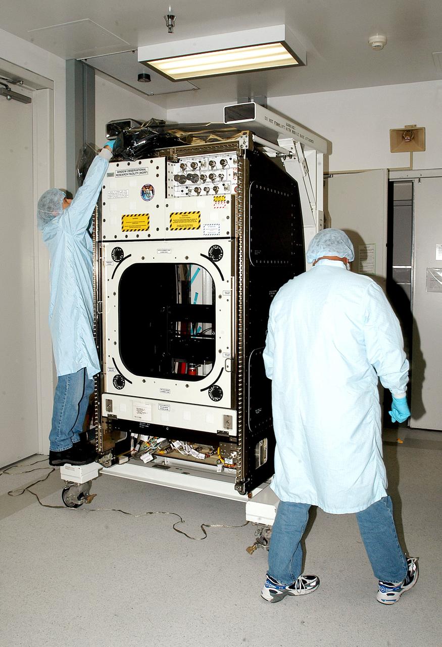
KENNEDY SPACE CENTER, FLA. - Workers in the Space Station Processing Facility check out the Window Observational Research Facility (WORF), designed and built by the Boeing Co. at NASA’s Marshall Space Flight Center in Huntsville, Ala. WORF will be delivered to the International Space Station and placed in the rack position in front of the Destiny lab window, providing locations for attaching cameras, multi-spectral scanners and other instruments. WORF will support a variety of scientific and commercial experiments in areas of Earth systems and processes, global ecological changes in Earth’s biosphere, lithosphere, hydrosphere and climate system, Earth resources, natural hazards, and education. After installation, it will become a permanent focal point for Earth Science research aboard the space station.
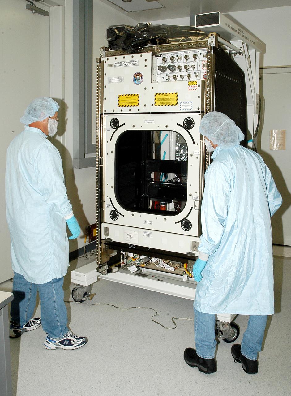
KENNEDY SPACE CENTER, FLA. - Workers in the Space Station Processing Facility check out the Window Observational Research Facility (WORF), designed and built by the Boeing Co. at NASA’s Marshall Space Flight Center in Huntsville, Ala. WORF will be delivered to the International Space Station and placed in the rack position in front of the Destiny lab window, providing locations for attaching cameras, multi-spectral scanners and other instruments. WORF will support a variety of scientific and commercial experiments in areas of Earth systems and processes, global ecological changes in Earth’s biosphere, lithosphere, hydrosphere and climate system, Earth resources, natural hazards, and education. After installation, it will become a permanent focal point for Earth Science research aboard the space station.
ISS011-E-11515 (5 August 2005) --- On the early Friday morning agenda for Astronauts James M. Kelly, pilot, and Wendy B. Lawrence, mission specialist, was important robotics duty at the controls of the Canadarm2 in the U.S. Lab, Destiny, on the International Space Station. Several digital photos in this sequence reveal the focal point of their work on the other end of the arm as the Italian-built Multi-Purpose Logistics Module Raffaello. The MPLM was being moved from its temporary parking place on the Station's Unity node to the payload bay of Discovery. The astronauts had arrived nine days ago with tons of fresh supplies for the Station, and with much effort, replaced that space on Raffaello with unneeded materials from the orbital outpost.

From left, Center Director Roy Bridges and NASA Administrator Daniel S. Goldin applaud as Jay Holliman, with the help of his mother, Mrs. Dianne Holliman, unveils a plaque honoring his father, the late John Holliman. At right is Tom Johnson, news group chairman of CNN. The occasion was the dedication of the KSC Press Site auditorium as the John Holliman Auditorium to honor the CNN national correspondent for his enthusiastic, dedicated coverage of America's space program. The auditorium was built in 1980 and has been the focal point for new coverage of Space Shuttle launches. The ceremony followed the 94th launch of a Space Shuttle, on mission STS-96, earlier this morning
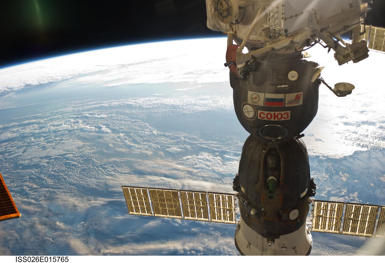
ISS026-E-015765 (6 Jan. 2011) --- Newfoundland and clouds over the North Atlantic Ocean share a scene with a Soyuz spacecraft docked to the International Space Station in this 35-mm focal length photograph recorded by one of the Expedition 26 crew members from 220 miles above Earth. The nadir point is 51.1 degrees north latitude and 50.4 degrees west longitude off the coast of Newfoundland. Looking southwestward, in the lower right hand corner, above the solar panel is the south coast of the island. The sun glint on the ocean’s surface outlines the islands (with the small hook-like appearance) of Saint Pierre and Miquelon.

Image taken 12/2/2000: The Lambert Glacier in Antarctica, is the world's largest glacier. The focal point of this image is an icefall that feeds into the Lambert glacier from the vast ice sheet covering the polar plateau. Ice flows like water, albeit much more slowly. Cracks can be seen in this icefall as it bends and twists on its slow-motion descent 1300 feet (400 meters) to the glacier below. This Icefall can be found on Landsat 7 WRS Path 42 Row 133/134/135, center: -70.92, 69.15. To learn more about the Landsat satellite go to: <a href="http://landsat.gsfc.nasa.gov/" rel="nofollow">landsat.gsfc.nasa.gov/</a>
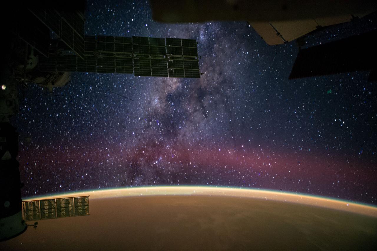
ISS041-E-045469 (27 Sept. 2014) --- One of the Expedition 41 crew members aboard the International Space Station, flying at an altitude of 222 nautical miles above a point in the Atlantic Ocean several hundred miles off the coast of Africa near the Tropic of Cancer, photographed this eye-catching panorama of the night sky on Sept. 27. NASA astronaut Reid Wiseman, flight engineer, tweeted the image, which was taken with an electronic still camera, set with a 24mm focal length. In his accompanying comments, Wiseman stated, "Sahara sands make the Earth glow orange."
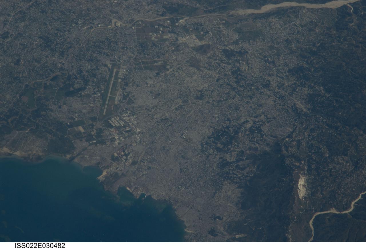
ISS022-E-030482 (18 Jan. 2010) --? An Expedition 22 crew member onboard the International Space Station took this image of the 260 year old city, Port-au-Prince on Jan. 18, 2010 when they could view the area. This was a few days after the major Haitian earthquake occurred and brought devastation to Port-au-Prince, Carrefour, and the surrounding region. The Toussaint Louverture International Airport, clearly visible on the north side of Port-au-Prince, is the central focal point of incoming international aid. The population of Port-au-Prince is estimated to be between 2.5 to 3 million people. The photo was taken with an 800 mm lens setting.
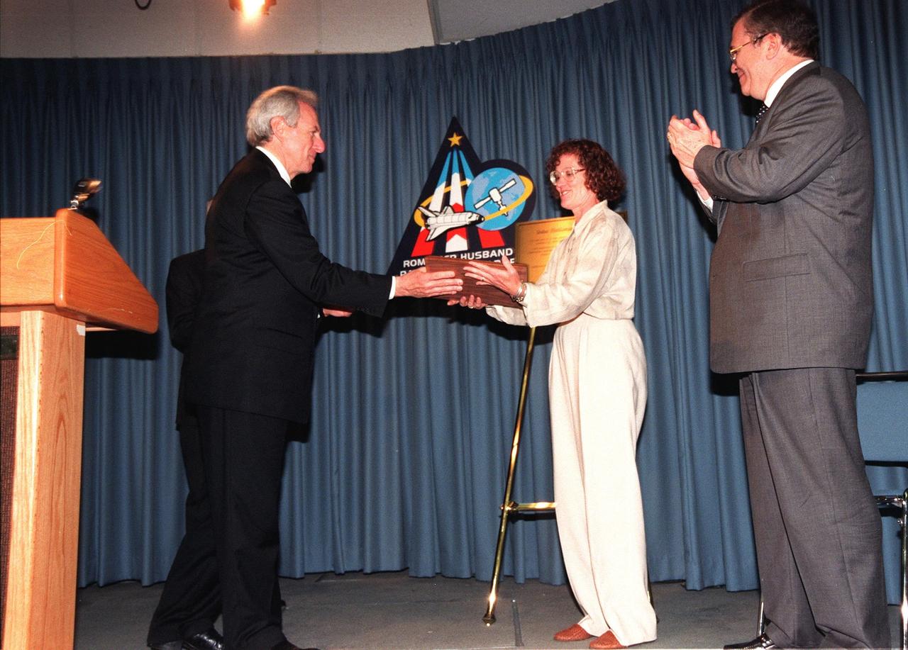
NASA Administrator Daniel S. Goldin hands Mrs. Dianne Holliman a plaque honoring her late husband, John Holliman, a CNN national correspondent. Standing behind Goldin is Center Director Roy Bridges. At right is Tom Johnson, news group chairman of CNN. A ceremony dedicated the KSC Press Site auditorium as the John Holliman Auditorium to honor the correspondent for his enthusiastic, dedicated coverage of America's space program. The auditorium was built in 1980 and has been the focal point for new coverage of Space Shuttle launches. The ceremony followed the 94th launch of a Space Shuttle, on mission STS-96, earlier this morning

This artist's concept depicts the 140-mile-wide (226-kilometer-wide) asteroid Psyche, which lies in the main asteroid belt between Mars and Jupiter. Psyche is the focal point of NASA's mission of the same name. The Psyche spacecraft is set to launch in August 2022 and arrive at the asteroid in 2026, where it will orbit for 21 months and investigate its composition. Scientists think that Psyche, unlike most other asteroids that are rocky or icy bodies, is made up of mostly iron and nickel — similar to the Earth's core. Exploring the asteroid could give valuable insight into how our own planet and others formed. The Psyche team will use a magnetometer to measure the asteroid's magnetic field. A multispectral imager will capture images of the surface, as well as data about the Psyche's composition and topography. Spectrometers will analyze the neutrons and gamma rays coming from the surface to reveal the elements that make up the asteroid itself. https://photojournal.jpl.nasa.gov/catalog/PIA23876
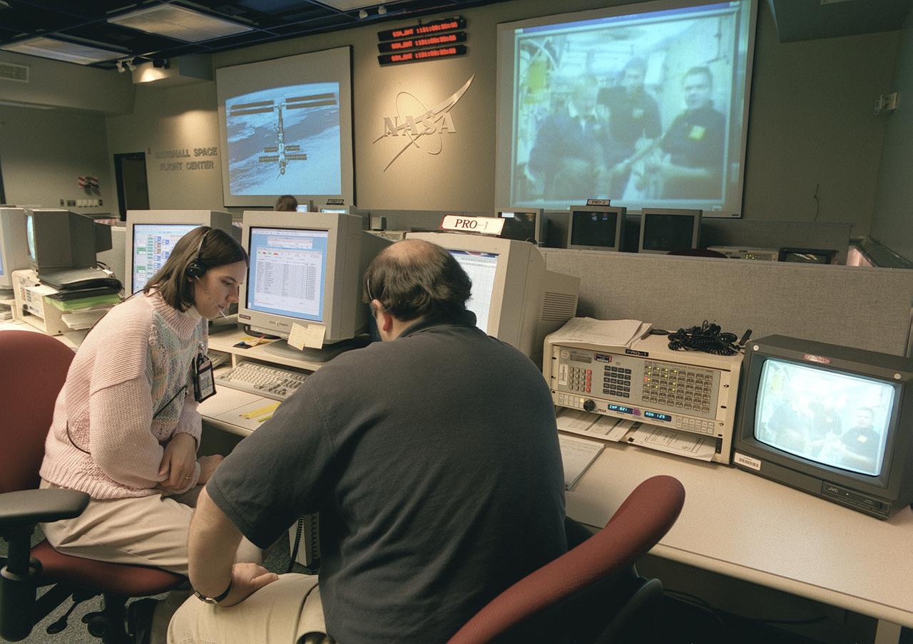
The Payload Operations Center (POC) is the science command post for the International Space Station (ISS). Located at NASA's Marshall Space Flight Center in Huntsville, Alabama, it is the focal point for American and international science activities aboard the ISS. The POC's unique capabilities allow science experts and researchers around the world to perform cutting-edge science in the unique microgravity environment of space. The POC is staffed around the clock by shifts of payload flight controllers. At any given time, 8 to 10 flight controllers are on consoles operating, plarning for, and controlling various systems and payloads. This photograph shows a Payload Rack Officer (PRO) at a work station. The PRO is linked by a computer to all payload racks aboard the ISS. The PRO monitors and configures the resources and environment for science experiments including EXPRESS Racks, multiple-payload racks designed for commercial payloads.
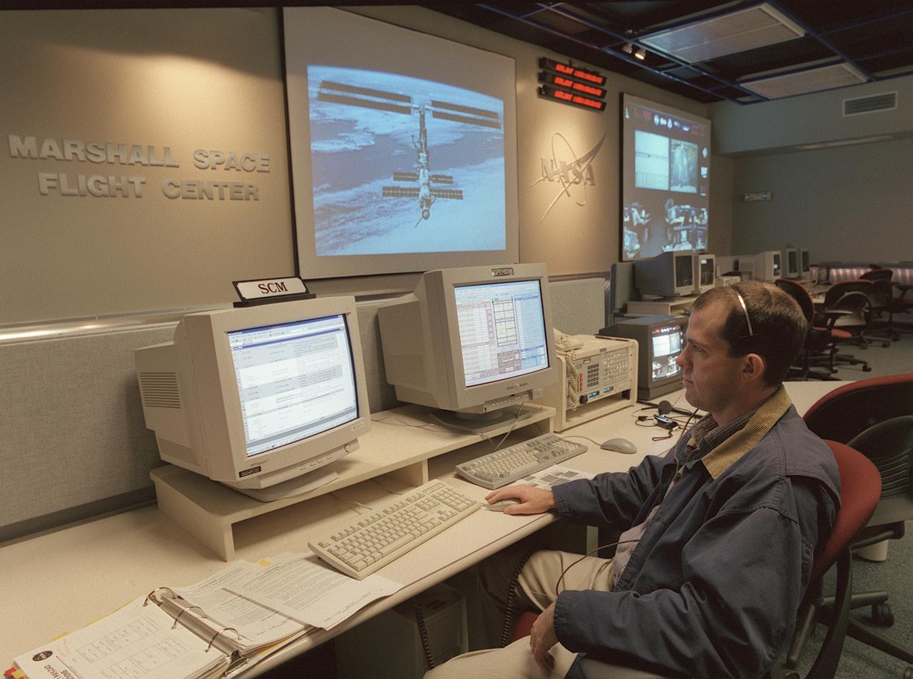
The Payload Operations Center (POC) is the science command post for the International Space Station (ISS). Located at NASA's Marshall Space Flight Center in Huntsville, Alabama, it is the focal point for American and international science activities aboard the ISS. The POC's unique capabilities allow science experts and researchers around the world to perform cutting-edge science in the unique microgravity environment of space. The POC is staffed around the clock by shifts of payload flight controllers. At any given time, 8 to 10 flight controllers are on consoles operating, plarning for, and controlling various systems and payloads. This photograph show the Safety Coordination Manager (SCM) at a work station. The SCM monitors science experiments to ensure they are conducted in a safe manner in accordance with strict safety regulations.

Suzhou is a major city located in southeastern Jiangsu Province of East China, about 100 km northwest of Shanghai. It is a major economic center and focal point of trade and commerce. The city is situated on the lower reaches of the Yangtze River and the shores of Lake Tai. Founded in 514 BCE, Suzhou has over 2,500 years of history, with an abundant display of relics and sites of historical interest. Since major economic reforms began in 1978, Suzhou has become one of the fastest growing major cities in the world. The population has grown from 0.9 million in 1990, 2.2 million in 2000, 4.1 million in 2010, to 5.3 million in 2017. The Landsat TM image was acquired August 4, 1984, and the Aster image was acquired August 2, 2015. The images cover an area of 48 by 53 km, and are located at 31.2 degrees north, 120.4 degrees east. https://photojournal.jpl.nasa.gov/catalog/PIA22266
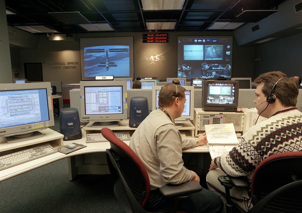
The Payload Operations Center (POC) is the science command post for the International Space Station (ISS). Located at NASA's Marshall Space Flight Center in Huntsville, Alabama, it is the focal point for American and international science activities aboard the ISS. The POC's unique capabilities allow science experts and researchers around the world to perform cutting-edge science in the unique microgravity environment of space. The POC is staffed around the clock by shifts of payload flight controllers. At any given time, 8 to 10 flight controllers are on consoles operating, plarning for, and controlling various systems and payloads. This photograph shows the Operations Controllers (OC) at their work stations. The OC coordinates the configuration of resources to enable science operations, such as power, cooling, commanding, and the availability of items like tools and laboratory equipment.

The Payload Operations Center (POC) is the science command post for the International Space Station (ISS). Located at NASA's Marshall Space Flight Center in Huntsville, Alabama, it is the focal point for American and international science activities aboard the ISS. The POC's unique capabilities allow science experts and researchers around the world to perform cutting-edge science in the unique microgravity environment of space. The POC is staffed around the clock by shifts of payload flight controllers. At any given time, 8 to 10 flight controllers are on consoles operating, plarning for, and controlling various systems and payloads. This photograph shows the Payload Communications Manager (PAYCOM) at a work station. The PAYCOM coordinates payload-related voice communications between the POC and the ISS crew. The PAYCOM is the voice of the POC.
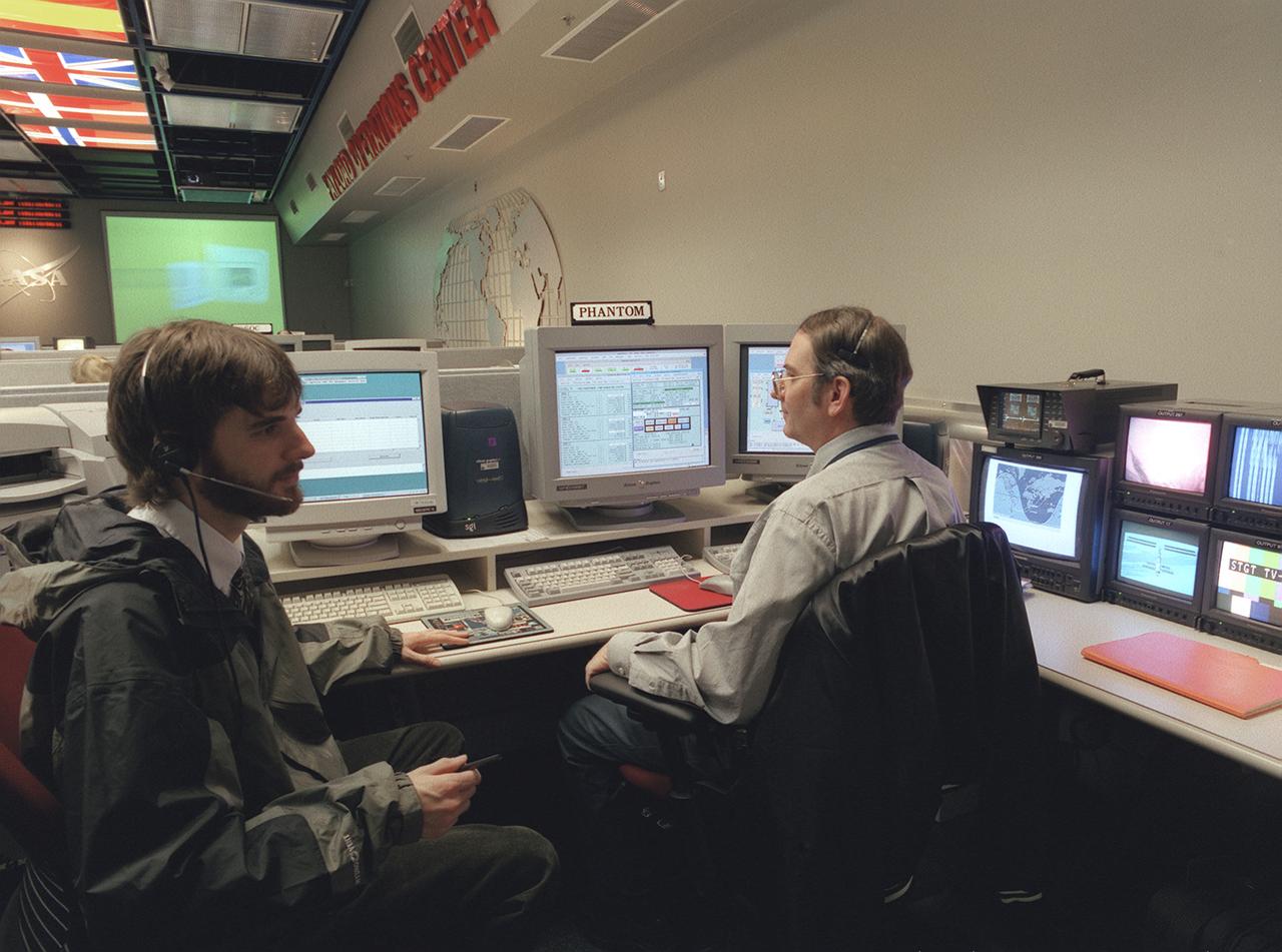
The Payload Operations Center (POC) is the science command post for the International Space Station (ISS). Located at NASA's Marshall Space Flight Center in Huntsville, Alabama, it is the focal point for American and international science activities aboard the ISS. The POC's unique capabilities allow science experts and researchers around the world to perform cutting-edge science in the unique microgravity environment of space. The POC is staffed around the clock by shifts of payload flight controllers. At any given time, 8 to 10 flight controllers are on consoles operating, plarning for, and controlling various systems and payloads. This photograph shows the Photo and TV Operations Manager (PHANTOM) at a work station. The PHANTOM configures all video systems aboard the ISS and ensures they are working properly, providing a video link from the ISS to the POC.
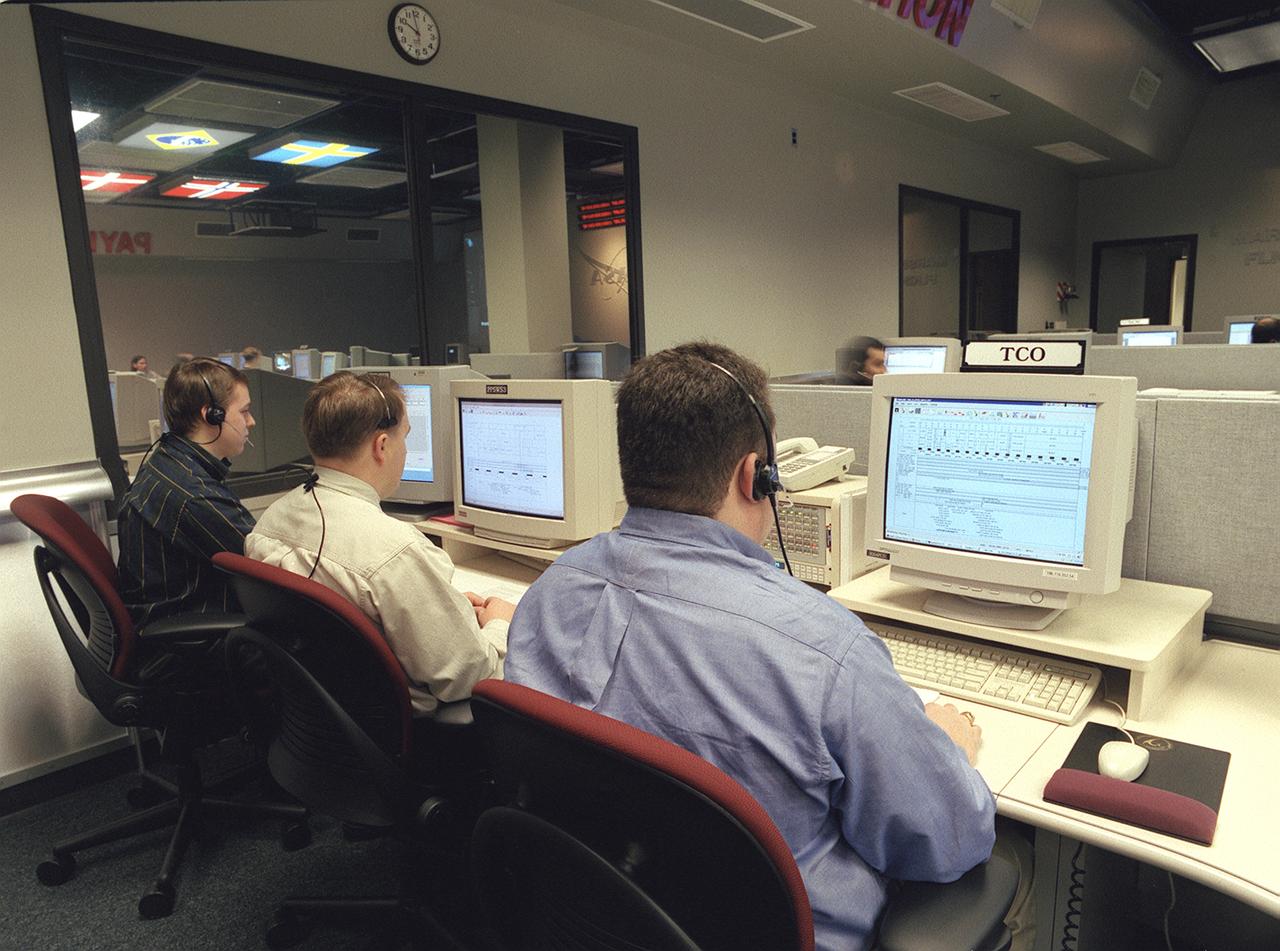
The Payload Operations Center (POC) is the science command post for the International Space Station (ISS). Located at NASA's Marshall Space Flight Center in Huntsville, Alabama, it is the focal point for American and international science activities aboard the ISS. The POC's unique capabilities allow science experts and researchers around the world to perform cutting-edge science in the unique microgravity environment of space. The POC is staffed around the clock by shifts of payload flight controllers. At any given time, 8 to 10 flight controllers are on consoles operating, plarning for, and controlling various systems and payloads. This photograph shows the Timeline Change Officer (TCO) at a work station. The TCO maintains the daily schedule of science activities and work assignments, and works with planners at Mission Control at Johnson Space Center in Houston, Texas, to ensure payload activities are accommodated in overall ISS plans and schedules.

The Payload Operations Center (POC) is the science command post for the International Space Station (ISS). Located at NASA's Marshall Space Flight Center (MSFC) in Huntsville, Alabama, it is the focal point for American and international science activities aboard the ISS. The POC's unique capabilities allow science experts and researchers around the world to perform cutting-edge science in the unique microgravity environment of space. The POC is staffed around the clock by shifts of payload flight controllers. At any given time, 8 to 10 flight controllers are on consoles operating, plarning for, and controlling various systems and payloads. This photograph shows the Command and Payload Multiplexer/Demultiplexer (MDM) Officers (CPO's) at their work stations. The CPO maintains the command link between the Operation Center at MSFC and Mission Control at Johnson Space Center in Houston, Texas, and configures the link to allow the international partners and remote scientists to operate their payloads from their home sites.
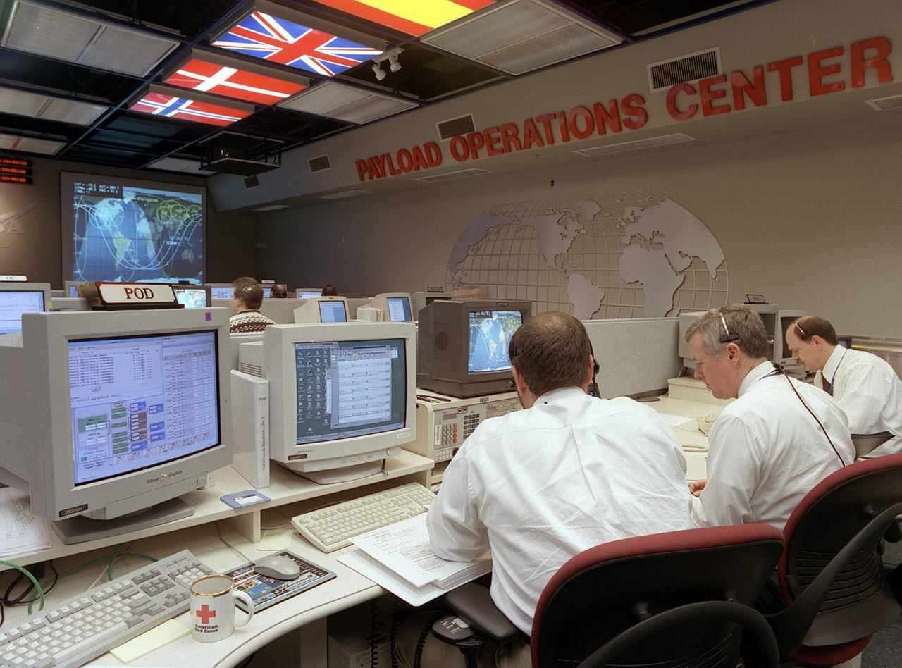
The Payload Operations Center (POC) is the science command post for the International Space Station (ISS). Located at NASA's Marshall Space Flight Center in Huntsville, Alabama, it is the focal point for American and international science activities aboard the ISS. The POC's unique capabilities allow science experts and researchers around the world to perform cutting-edge science in the unique microgravity environment of space. The POC is staffed around the clock by shifts of payload flight controllers. At any given time, 8 to 10 flight controllers are on consoles, operating, plarning for, and controlling various systems and payloads. This photograph shows the Payload Operations Director (POD) at work. The POD is the leader of the POC flight control team. The Director guides all payload activities in coordination with Mission Control at Johnson Space Center at Houston, Texas, the Station crew, the international partners, and other research facilities.
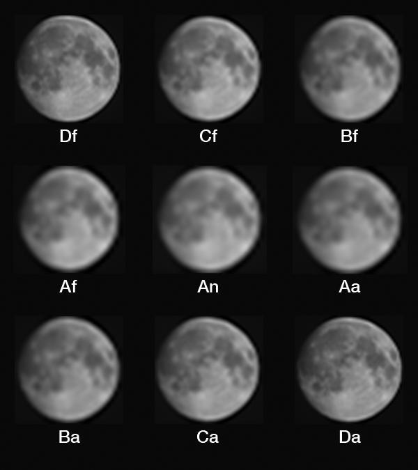
The job of the Multiangle Imaging SpectroRadiometer (MISR) instrument on NASA's Terra satellite is to view Earth. For more than 17 years, its nine cameras have stared downward 24 hours a day, faithfully collecting images used to study Earth's surface and atmosphere. On August 5, however, MISR captured some very unusual data as the Terra satellite performed a backflip in space. This maneuver was performed to allow MISR and the other instruments on Terra to catch a glimpse of the Moon, something that has been done only once before, in 2003. Why task an elderly satellite with such a radical maneuver? Since we can be confident that the Moon's brightness has remained very constant over the mission, MISR's images of the Moon can be used as a check of the instrument's calibration, allowing an independent verification of the procedures used to correct the images for any changes the cameras have experienced over their many years in space. If changes in the cameras' responses to light aren't properly accounted for, the images captured by MISR would make it appear as if Earth were growing darker or lighter, which would throw off scientists' efforts to characterize air pollution, cloud cover and Earth's climate. Because of this, the MISR team uses several methods to calibrate the data, all of which involve imaging something with a known (or independently measured) brightness and correcting the images to match that brightness. Every month, MISR views two panels of a special material called Spectralon, which reflects sunlight in a very particular way, onboard the instrument. Periodically, this calibration is checked by a field team who measures the brightness of a flat, uniformly colored surface on Earth, usually a dry desert lakebed, as MISR flies overhead. The lunar maneuver offers a third opportunity to check the brightness calibration of MISR's images. While viewing Earth, MISR's cameras are fixed at nine different angles, with one (called An) pointed straight down, four canted forwards (Af, Bf, Cf, and Df) and four angled backwards (Aa, Ba, Ca, and Da). The A, B, C, and D cameras have different focal lengths, with the most oblique (D) cameras having the longest focal lengths in order to preserve spatial resolution on the ground. During the lunar maneuver, however, the spacecraft rotated so that each camera saw the almost-full Moon straight on. This means that the different focal lengths produce images with different resolutions. The D cameras produce the sharpest images. These grayscale images were made with raw data from the red spectral band of each camera. Because the spacecraft is constantly rotating while these images were taken, the images are "smeared" in the vertical direction, producing an oval-shaped Moon. These have been corrected to restore the Moon to its true circular shape. https://photojournal.jpl.nasa.gov/catalog/PIA21876
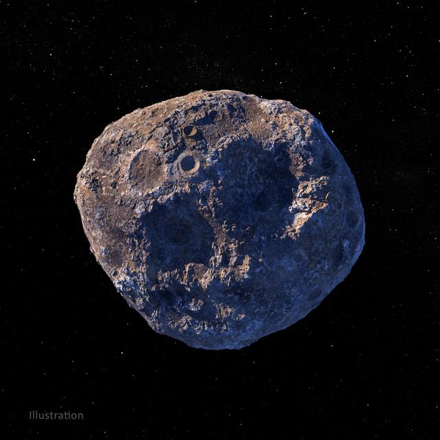
This illustration, created in March 2021, depicts the 140-mile-wide (226-kilometer-wide) asteroid Psyche, which lies in the main asteroid belt between Mars and Jupiter. Psyche is the focal point of NASA's mission of the same name. The Psyche spacecraft is set to launch in August 2022 and arrive at the asteroid in 2026, where it will orbit for 21 months and investigate its composition. Based on data obtained from Earth, scientists believe Psyche is a mixture of metal and rock. The rock and metal may be in large provinces, or areas, on the asteroid — as depicted in an illustration here: PIA24471. Another possibility is that rock and metal may be intimately mixed on a scale too small to detect from orbit — as depicted in the illustration above. Observing and measuring how the metal and rock are mixed will help scientists determine how Psyche formed. Exploring the asteroid could also give valuable insight into how our own planet and others formed. The Psyche team will use a magnetometer to measure the asteroid's magnetic field. A multispectral imager will capture images of the surface, as well as data about the Psyche's composition and topography. Spectrometers will analyze the neutrons and gamma rays coming from the surface to reveal the elements that make up the asteroid itself. The image was created by Peter Rubin. https://photojournal.jpl.nasa.gov/catalog/PIA24472
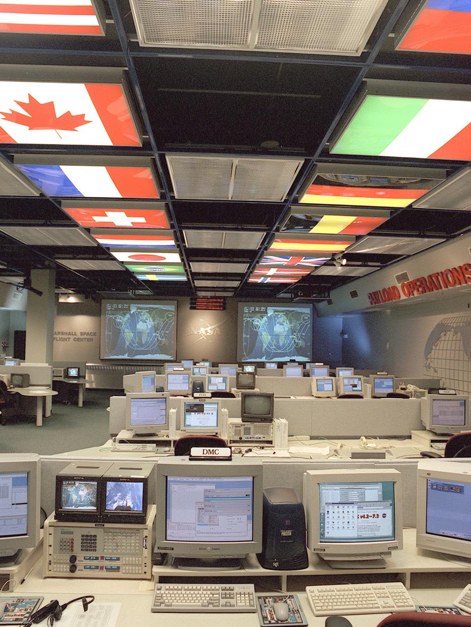
The International Space Station (ISS) Payload Operations Center (POC) at NASA's Marshall Space Flight Center (MSFC) in Huntsville, Alabama, is the world's primary science command post for the (ISS), the most ambitious space research facility in human history. The Payload Operations team is responsible for managing all science research experiments aboard the Station. The center is also home for coordination of the mission-plarning work of variety of international sources, all science payload deliveries and retrieval, and payload training and safety programs for the Station crew and all ground personnel. Within the POC, critical payload information from the ISS is displayed on a dedicated workstation, reading both S-band (low data rate) and Ku-band (high data rate) signals from a variety of experiments and procedures operated by the ISS crew and their colleagues on Earth. The POC is the focal point for incorporating research and experiment requirements from all international partners into an integrated ISS payload mission plan. This photograph is an overall view of the MSFC Payload Operations Center displaying the flags of the countries participating in the ISS. The flags at the left portray The United States, Canada, France, Switzerland, Netherlands, Japan, Brazil, and Sweden. The flags at the right portray The Russian Federation, Italy, Germany, Belgium, Spain, United Kingdom, Denmark, and Norway.
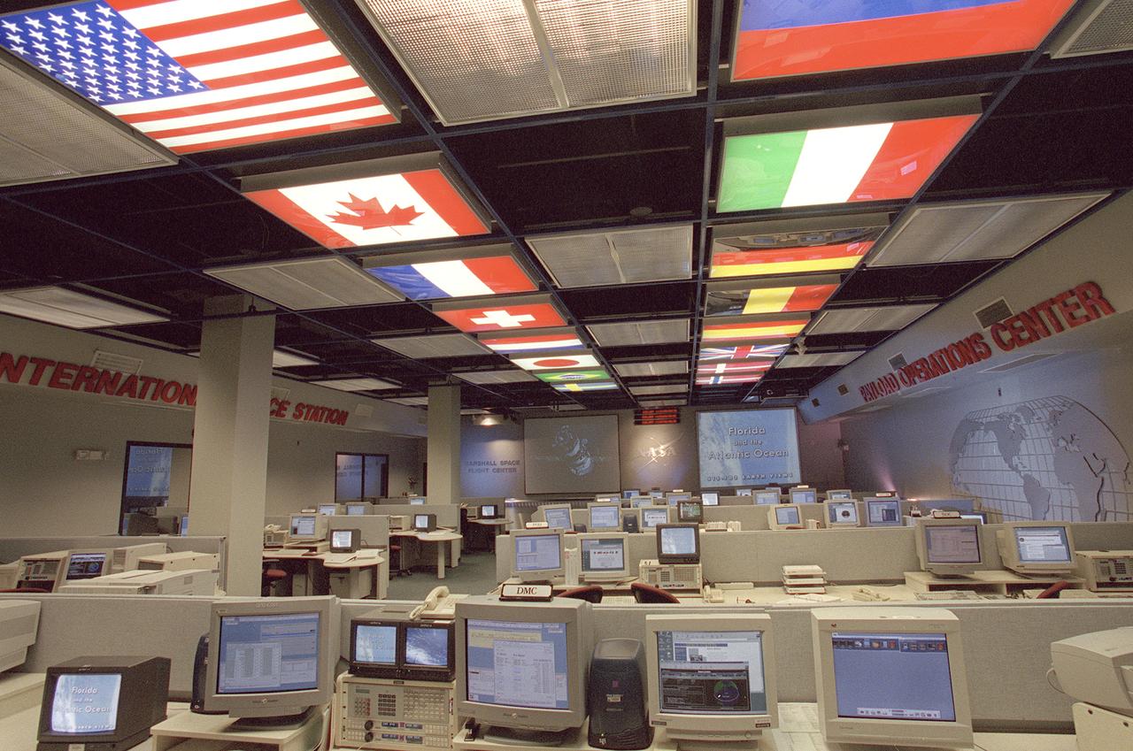
The International Space Station (ISS) Payload Operations Center (POC) at NASA's Marshall Space Flight Center (MSFC) in Huntsville, Alabama, is the world's primary science command post for the International Space Station (ISS), the most ambitious space research facility in human history. The Payload Operations team is responsible for managing all science research experiments aboard the Station. The center is also home for coordination of the mission-plarning work of variety of international sources, all science payload deliveries and retrieval, and payload training and safety programs for the Station crew and all ground personnel. Within the POC, critical payload information from the ISS is displayed on a dedicated workstation, reading both S-band (low data rate) and Ku-band (high data rate) signals from a variety of experiments and procedures operated by the ISS crew and their colleagues on Earth. The POC is the focal point for incorporating research and experiment requirements from all international partners into an integrated ISS payload mission plan. This photograph is an overall view of the MSFC Payload Operations Center displaying the flags of the countries participating the ISS. The flags at the left portray The United States, Canada, France, Switzerland, Netherlands, Japan, Brazil, and Sweden. The flags at the right portray The Russian Federation, Italy, Germany, Belgium, Spain, United Kingdom, Denmark, and Norway.
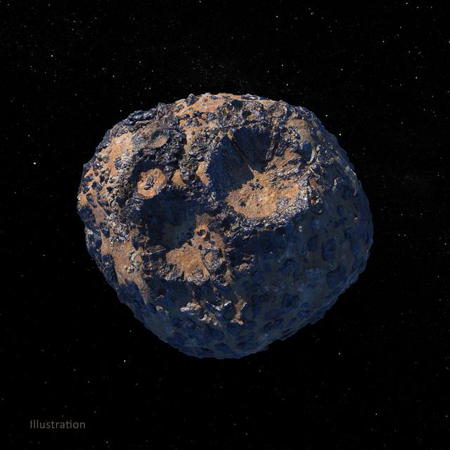
This illustration, created in March 2021, depicts the 140-mile-wide (226-kilometer-wide) asteroid Psyche, which lies in the main asteroid belt between Mars and Jupiter. Psyche is the focal point of NASA's mission of the same name. The Psyche spacecraft is set to launch in August 2022 and arrive at the asteroid in 2026, where it will orbit for 21 months and investigate its composition. Based on data obtained from Earth, scientists believe Psyche is a mixture of metal and rock. The rock and metal may be in large provinces, or areas, on the asteroid — as illustrated in this rendering. Another possibility is that rock and metal may be intimately mixed on a scale too small to detect from orbit — as depicted in an illustration here: PIA24472. Observing and measuring how the metal and rock are mixed will help scientists determine how Psyche formed. Exploring the asteroid could also give valuable insight into how our own planet and others formed. The Psyche team will use a magnetometer to measure the asteroid's magnetic field. A multispectral imager will capture images of the surface, as well as data about the Psyche's composition and topography. Spectrometers will analyze the neutrons and gamma rays coming from the surface to reveal the elements that make up the asteroid itself. The image was created by Peter Rubin. https://photojournal.jpl.nasa.gov/catalog/PIA24471
This photograph shows an overall view of the Solar Thermal Propulsion Test Facility at the Marshall Space Flight Center (MSFC). The 20-by 24-ft heliostat mirror, shown at the left, has dual-axis control that keeps a reflection of the sunlight on an 18-ft diameter concentrator mirror (right). The concentrator mirror then focuses the sunlight to a 4-in focal point inside the vacuum chamber, shown at the front of concentrator mirror. Researchers at MSFC have designed, fabricated, and tested the first solar thermal engine, a non-chemical rocket engine that produces lower thrust but has better thrust efficiency than chemical a combustion engine. MSFC turned to solar thermal propulsion in the early 1990s due to its simplicity, safety, low cost, and commonality with other propulsion systems. Solar thermal propulsion works by acquiring and redirecting solar energy to heat a propell nt. As part of MSFC's Space Transportation Directorate, the Propulsion Research Center serves as a national resource for research of advanced, revolutionary propulsion technologies. The mission is to move the Nation's capabilities beyond the confines of conventional chemical propulsion into an era of aircraft-like access to Earth-orbit, rapid travel throughout the solar system, and exploration of interstellar space.
ISS023-S-001B (November 2009) --- The focal point of the Expedition XXIII emblem illustrates the beautiful planet Earth in the black expanse of space. The International Space Station (ISS) is shown traveling in its orbit around Earth. The ISS orbital path flies through the XXIII to show that this increment is building upon the missions that have gone on before and laying the groundwork for future missions. This illustrates the work being performed aboard the orbiting complex that will lead the way to eventual missions to the moon, Mars and beyond. The mission designation uses Roman numerals to illustrate the home nations of the crew, which are also represented by their national flags. The two stars represent the two teams that make up this expedition crew. The NASA insignia design for shuttle and space station flights is reserved for use by the astronauts and for other official use as the NASA Administrator may authorize. Public availability has been approved only in the form of illustrations by the various news media. When and if there is any change in this policy, which is not anticipated, it will be publicly announced.

ISS023-S-001A (November 2009) --- The focal point of the Expedition XXIII emblem illustrates the beautiful planet Earth in the black expanse of space. The International Space Station (ISS) is shown traveling in its orbit around Earth. The ISS orbital path flies through the XXIII to show that this increment is building upon the missions that have gone on before and laying the groundwork for future missions. This illustrates the work being performed aboard the orbiting complex that will lead the way to eventual missions to the moon, Mars and beyond. The mission designation uses Roman numerals to illustrate the home nations of the crew, which are also represented by their national flags. The two stars represent the two teams that make up this expedition crew. The NASA insignia design for shuttle and space station flights is reserved for use by the astronauts and for other official use as the NASA Administrator may authorize. Public availability has been approved only in the form of illustrations by the various news media. When and if there is any change in this policy, which is not anticipated, it will be publicly announced.

ISS015-E-25044 (3 Sept. 2007) --- This view of Hurricane Felix was taken from the Earth-orbiting International Space Station (ISS) by an Expedition 15 crewmember using a digital still camera equipped with a 28-70 mm lens set at 28 mm focal length on Sept. 3, 2007 at 11:38:29 GMT. The ISS was located at the nadir point of 16.0 degrees north latitude and 84.0 degrees west longitude nearly over the coast of eastern Honduras when this image was taken. At approximately noon GMT, Hurricane Felix was near 14.2 degrees north latitude and 76.9 degrees west longitude, about 260 miles (425 kilometers) south of Kingston Jamaica, and 425 miles (685 kilometers) east of Cabo Gracias a Dios on the Nicaragua/Honduras border, moving west at 21 miles per hour (33 kilometers per hour). The sustained winds were 165 miles per hour with higher gusts making it a category 5 on the Saffir-Simpson scale.

ISS015-E-25049 (3 Sept. 2007) --- This view of Hurricane Felix was taken from the Earth-orbiting International Space Station (ISS) by an Expedition 15 crewmember using a digital still camera equipped with a 28-70 mm lens set at 28 mm focal length on Sept. 3, 2007 at 11:38:46 GMT. The ISS was located at the nadir point of 16.9 degrees north latitude and 83.3 degrees west longitude, over the waters southwest of Grand Cayman Island. At approximately noon GMT, Hurricane Felix was near 14.2 degrees north latitude and 76.9 west longitude, about 260 miles (425 kilometers) south of Kingston Jamaica, and 425 miles (685 kilometers) east of Cabo Gracias a Dios on the Nicaragua/Honduras border, moving west at 21 miles per hour (33 kilometers per hour). The sustained winds were 165 miles per hour with higher gusts making it a category 5 on the Saffir-Simpson scale.
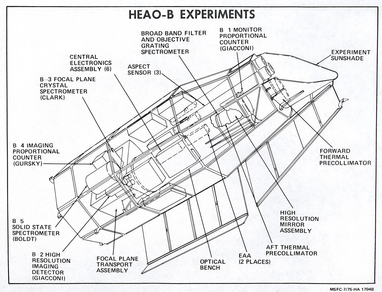
This illustration is a schematic of the High Energy Astronomy Observatory (HEAO)-2 and its experiments. It shows the focal plane instruments (at the right) plus the associated electronics for operating the telescope as it transmitted its observations to the ground. A fifth instrument, the Monitor Proportional Counter, is located near the front of the telescope. Four separate astronomical instruments are located at the focus of this telescope and they could be interchanged for different types of observations as the observatory pointed at interesting areas of the Sky. Two of these instruments produced images; a High Resolution Imaging Detector and an Imaging Proportional Counter. The other two instruments, the Solid State Spectrometer and the Crystal Spectrometer, measured the spectra of x-ray objects. A fifth instrument, the Monitor Proportional Counter, continuously viewed space independently to study a wider band of x-ray wavelengths and to examine the rapid time variations in the sources. The HEAO-2 was nicknamed the Einstein Observatory by its scientific experimenters in honor of the centernial of the birth of Albert Einstein, whose concepts of relativity and gravitation have influenced much of modern astrophysics, particularly x-ray astronomy. The HEAO-2, designed and developed by TRW, Inc. under the project management of the Marshall Space Flight Center, was launched aboard an Atlas/Centaur launch vehicle on November 13, 1978. The HEAO-2 was originally identified as HEAO-B but the designation was changed once the spacecraft achieved orbit.
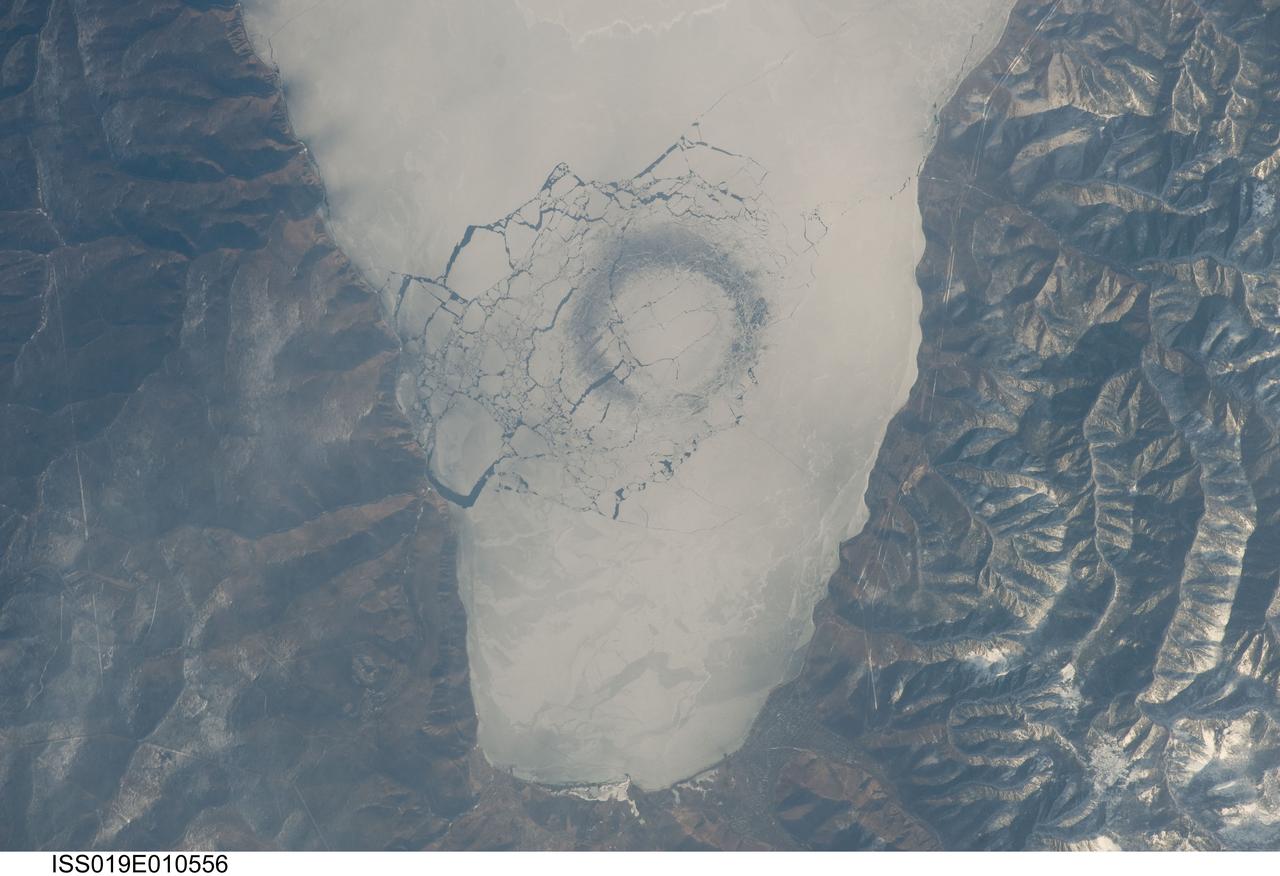
ISS019-E-010556 (23 April 2009) --- A circle in thin ice in Lake Baikal, Russia is featured in this image photographed by an Expedition 19 crewmember on the International Space Station. Late in April 2009, astronauts aboard the station observed a strange circular area of thinned ice (dark in color, with a diameter of about 4.4 kilometers) in the southern end of Lake Baikal in southern Siberia. Lake Baikal is unique in many regards. It is the largest (by volume) and deepest (1,637 meters at the deepest point) fresh water lake on Earth and, as a World Heritage Site, is considered one of Russia?s environmental jewels. The lake?s long, thin and deep profile results from its location in the Baikal Rift valley in Siberia. According to scientists, it is also one of the world?s oldest lakes (25-30 million years old); it contains up to 7 kilometers of sediment deposited on the bottom, and is home to an amazing array of plants and animals, many being found only in Lake Baikal. The lake?s biodiversity includes fresh water seals and several species of fish that are not found elsewhere on Earth. Siberia is remote and cold; ice cover can persist into June. This detailed image shows a circle of thin ice, which is the focal point for ice break up in the very southern end of the lake. While the origin of the circles is unknown, the peculiar pattern suggests convection in the lake?s water column. Ice cover changes rapidly at this time of year. Within a day, the ice can melt almost completely, and then freeze again overnight. Throughout April, the circles are persistent ? they appear when ice cover forms, and then disappear as ice melts. The pattern and appearance suggests that the ice is quite thin.

This color image of the sun, Earth and Venus was taken by the Voyager 1 spacecraft Feb. 14, 1990, when it was approximately 32 degrees above the plane of the ecliptic and at a slant-range distance of approximately 4 billion miles. It is the first -- and may be the only -- time that we will ever see our solar system from such a vantage point. The image is a portion of a wide-angle image containing the sun and the region of space where the Earth and Venus were at the time with two narrow-angle pictures centered on each planet. The wide-angle was taken with the camera's darkest filter (a methane absorption band), and the shortest possible exposure (5 thousandths of a second) to avoid saturating the camera's vidicon tube with scattered sunlight. The sun is not large in the sky as seen from Voyager's perspective at the edge of the solar system but is still eight million times brighter than the brightest star in Earth's sky, Sirius. The image of the sun you see is far larger than the actual dimension of the solar disk. The result of the brightness is a bright burned out image with multiple reflections from the optics in the camera. The "rays" around the sun are a diffraction pattern of the calibration lamp which is mounted in front of the wide angle lens. The two narrow-angle frames containing the images of the Earth and Venus have been digitally mosaiced into the wide-angle image at the appropriate scale. These images were taken through three color filters and recombined to produce a color image. The violet, green and blue filters were used; exposure times were, for the Earth image, 0.72, 0.48 and 0.72 seconds, and for the Venus frame, 0.36, 0.24 and 0.36, respectively. Although the planetary pictures were taken with the narrow-angle camera (1500 mm focal length) and were not pointed directly at the sun, they show the effects of the glare from the nearby sun, in the form of long linear streaks resulting from the scattering of sunlight off parts of the camera and its sun shade. From Voyager's great distance both Earth and Venus are mere points of light, less than the size of a picture element even in the narrow-angle camera. Earth was a crescent only 0.12 pixel in size. Coincidentally, Earth lies right in the center of one of the scattered light rays resulting from taking the image so close to the sun. Detailed analysis also suggests that Voyager detected the moon as well, but it is too faint to be seen without special processing. Venus was only 0.11 pixel in diameter. The faint colored structure in both planetary frames results from sunlight scattered in the optics. http://photojournal.jpl.nasa.gov/catalog/PIA00450
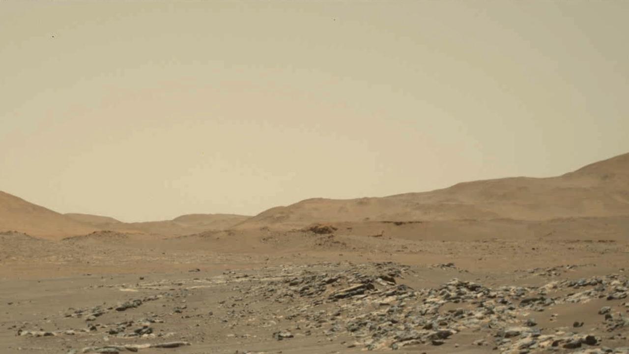
Video footage from NASA's Perseverance Mars rover provides a big-picture perspective of the 13th flight of NASA's Ingenuity Mars Helicopter. The 160.5-second reconnaissance sortie involved flying into challenging terrain and taking images of a specific rocky outcrop from multiple angles. Captured from a distance of about 980 feet (300 meters) by the rover's two-camera Mastcam-Z, Ingenuity is barely discernable near the lower left of frame at the beginning of the video. An annotated version of this video highlighting the location of Ingenuity can be found here. At 0:04 seconds into the video Ingenuity takes off and climbs to an altitude of to 26 feet (8 meters) before beginning its sideways translation to the right. At the video's 0:59 second point, Ingenuity leaves the camera's field of view on the right. Soon after (1:02), the helicopter returns into the field of view (the majority of frames that did not capture helicopter after it exited the camera's field of view were purposely not downlinked from Mars by the team) and lands at a location near its takeoff point. To obtain the footage, the "left eye" of the Mastcam-Z instrument is set for a wide-angle shot (26 mm focal length). The video is shot at 6 frames per second. Another view (PIA24979) is taken at the same time by Mastcam-Z's other ("right eye") imager and provides a closer perspective of the helicopter as it took off and landed. The Mastcam-Z investigation is led and operated by Arizona State University in Tempe, working in collaboration with Malin Space Science Systems in San Diego, California, on the design, fabrication, testing, and operation of the cameras, and in collaboration with the Neils Bohr Institute of the University of Copenhagen on the design, fabrication, and testing of the calibration targets. A key objective for Perseverance's mission on Mars is astrobiology, including the search for signs of ancient microbial life. The rover will characterize the planet's geology and past climate, pave the way for human exploration of the Red Planet, and be the first mission to collect and cache Martian rock and regolith (broken rock and dust). Subsequent NASA missions, in cooperation with ESA (European Space Agency), would send spacecraft to Mars to collect these sealed samples from the surface and return them to Earth for in-depth analysis. The Mars 2020 Perseverance mission is part of NASA's Moon to Mars exploration approach, which includes Artemis missions to the Moon that will help prepare for human exploration of the Red Planet. Movie available at https://photojournal.jpl.nasa.gov/catalog/PIA24978

ISS030-E-099324 (22 Feb. 2012) --- City lights of Dubai, United Arab Emirates are featured in this image photographed by an Expedition 30 crew member on the International Space Station. The City of Dubai?the largest metropolitan area within the emirate of Dubai?is a favorite subject of astronaut photography largely due to the unique island developments situated directly offshore in the Persian Gulf. These artificial archipelagos have been built such that their full design is only visible from the vantage point of an airplane ? or an orbiting spacecraft such as the International Space Station. The city presents an eye-catching appearance at night that vividly displays the urban development pattern. In this detailed nighttime image?taken with a long focal length lens and digital camera optimized for fast response and high light sensitivity?several interesting patterns can be observed. The highways and major streets are sharply defined by yellow-orange lighting, while the commercial and residential areas are resolved into a speckle pattern of individual white, blue, and yellow-orange lights. Several large and brilliantly lit areas are large hotel and mall complexes, including the Burj Khalifa Tower; at 828 meters (2,717 feet) height it is the world?s tallest building. The brilliant lighting of the city contrasts sharply with both the dark Persian Gulf to the northwest, and largely undeveloped and unlit areas to the southeast. Likewise, the clusters of lighting in the Palm Jumeira complex at bottom right correspond to the relatively small part of the archipelago that has been developed. Isolated areas of blurred city lights are due to patchy clouds.
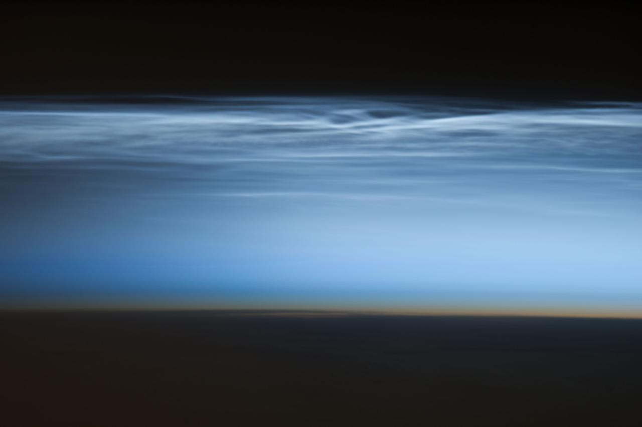
ISS034-E-024622 (5 Jan. 2013) --- Polar mesospheric clouds over the South Pacific Ocean are featured in this image photographed by an Expedition 34 crew member on the International Space Station. Polar mesospheric clouds—also known as noctilucent, or “night shining” clouds—are formed 76 to 85 kilometers above Earth’s surface near the mesosphere-thermosphere boundary of the atmosphere, a region known as the mesopause. At these altitudes, water vapor can freeze into clouds of ice crystals. When the sun is below the horizon such that the ground is in darkness, these high clouds may still be illuminated—lending them their ethereal, “night shining” qualities. Noctilucent clouds have been observed from all human vantage points in both the Northern and Southern Hemispheres – from the surface, in aircraft, and in orbit from the space station—and tend to be most visible during the late spring and early summer seasons. Polar mesospheric clouds also are of interest to scientists studying the atmosphere. While some scientists seek to understand their mechanisms of formation, others have identified them as potential indicators of atmospheric changes resulting from increases in greenhouse gas concentrations. This photograph was taken when the station was over the Pacific Ocean south of French Polynesia. While most polar mesospheric cloud images are taken from the orbital complex with relatively short focal length lens to maximize the field of view, this image was taken with a long lens (400 mm) allowing for additional detail of the cloud forms to be seen. Below the brightly-lit noctilucent clouds in the center of the image, the pale orange band indicates the stratosphere.

Acadia National Park is one of the most visited parks in America, drawing more than 2.5 million visitors per year to the craggy, jagged coast of Maine. The park is celebrating its 100th anniversary in 2016. On September 6, 2015, the Operational Land Imager (OLI) on the Landsat 8 satellite acquired these images of Acadia National Park and its surroundings. Mountains and hills roll right up to the Atlantic Ocean in this rocky landscape carved by glaciers at the end of the last Ice Age. Since the beginning of the 20th Century, the park has been pieced together by donations and acquisitions of once-private lands, and it is still growing. Of the park’s 47,000 acres, more than 12,000 are privately owned lands under conservation agreements, while the rest is held by the National Park Service. Mount Desert Island is the focal point of the park, which also includes lands around a former naval base (Schoodic Peninsula), Isle au Haut, and several smaller islands. Read more: <a href="http://go.nasa.gov/2adyd8J" rel="nofollow">go.nasa.gov/2adyd8J</a> Credit: NASA/Landsat8 <b><a href="http://www.nasa.gov/audience/formedia/features/MP_Photo_Guidelines.html" rel="nofollow">NASA image use policy.</a></b> <b><a href="http://www.nasa.gov/centers/goddard/home/index.html" rel="nofollow">NASA Goddard Space Flight Center</a></b> enables NASA’s mission through four scientific endeavors: Earth Science, Heliophysics, Solar System Exploration, and Astrophysics. Goddard plays a leading role in NASA’s accomplishments by contributing compelling scientific knowledge to advance the Agency’s mission. <b>Follow us on <a href="http://twitter.com/NASAGoddardPix" rel="nofollow">Twitter</a></b> <b>Like us on <a href="http://www.facebook.com/pages/Greenbelt-MD/NASA-Goddard/395013845897?ref=tsd" rel="nofollow">Facebook</a></b> <b>Find us on <a href="http://instagrid.me/nasagoddard/?vm=grid" rel="nofollow">Instagram</a></b>

This image from NASA Kepler mission shows the telescope full field of view an expansive star-rich patch of sky in the constellations Cygnus and Lyra stretching across 100 square degrees, or the equivalent of two side-by-side dips of the Big Dipper. A cluster of stars, called NGC 6791, and a star with a known planet, called TrES-2, are outlined. The cluster is eight billion years old, and located 13,000 light-years from Earth. It is called an open cluster because its stars are loosely bound and have started to spread out. TrES-2 is a hot Jupiter-like planet known to cross in front of, or transit, its star every 2.5 days. Kepler will hunt for transiting planets that are as small as Earth. Kepler was designed to hunt for planets like Earth. Of the approximately 4.5 million stars in the region pictured here, more than 100,000 were selected as candidates for Kepler's search. The mission will spend the next three-and-a-half years staring at these target stars, looking for periodic dips in brightness. Such dips occur when planets cross in front of their stars from our point of view in the galaxy, partially blocking the starlight. The area in the lower right of the image is brighter because it is closer to the plane of our galaxy and is jam-packed with stars. The area in upper left is farther from the galactic plane and contains fewer stars. The image has been color-coded so that brighter stars appear white, and fainter stars, red. It is a 60-second exposure, taken on April 8, 2009, one day after the spacecraft's dust cover was jettisoned. To achieve the level of precision needed to spot planets as small as Earth, Kepler's images are intentionally blurred slightly. This minimizes the number of saturated stars. Saturation, or "blooming," occurs when the brightest stars overload the individual pixels in the detectors, causing the signal to spill out into nearby pixels. These spills can be seen in the image as fine white lines extending above and below some of the brightest stars. Blooming is an expected side effect of Kepler's ultra-sensitive camera. Some of the lightly saturated stars are candidates for planet searches, while those that are heavily saturated are not. The grid lines across the picture show how the focal plane is laid out on Kepler's camera —the largest ever launched in space at 95 megapixels. There are 42 charge-coupled devices (CCDs), paired into square-shaped modules, whose outline can be seen in the image. A thin black line in each module shows adjacent pairs of CCDs. The thicker black lines that cross through the image are from structures holding the modules together, and were purposely oriented to block out the very brightest stars in Kepler's field of view. The four black corners of the image show where the fine-guidance sensors reside on the focal plane. These sensors are used to hold the telescope's gaze steady by measuring its position on the sky 10 times every second, and by feeding this information to the spacecraft's attitude control system. Ghost images also appear in the image, which are reflections off the lenses above the CCDs. These expected artifacts were mapped out during ground testing for Kepler, and will not affect science observations because they will be removed as the data are processed. http://photojournal.jpl.nasa.gov/catalog/PIA11984
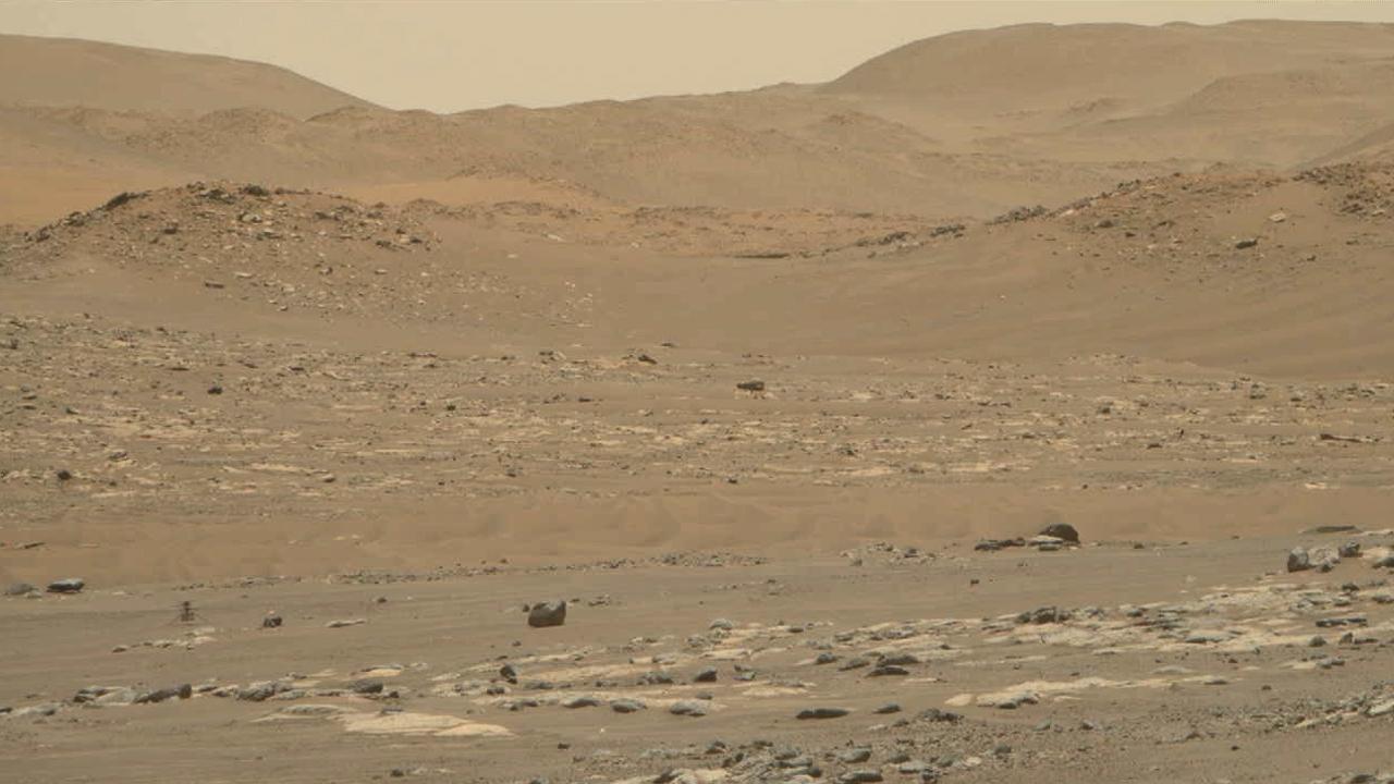
Video footage from the Mastcam-Z instrument aboard NASA's Perseverance Mars rover captured this closeup view of the takeoff and landing of the 13th flight of the Ingenuity Mars Helicopter on Sept. 4, 2021. The 160.5-second reconnaissance sortie involved flying into challenging terrain and taking images of a specific outcrop from multiple angles. The closeup video of takeoff and landing was acquired as part of a science observation intended to measure the dust plumes generated by the helicopter. At the beginning of the video, Ingenuity is near the lower left of frame, at a distance of about 980 feet (300 meters) from the rover. It climbs to an altitude of to 26 feet (8 meters) before beginning its sideways translation. The helicopter leaves the camera's field of view on the right. Soon after, the helicopter returns into the field of view (the majority of frames that did not capture helicopter after it exited the camera's field of view were purposely not downlinked from Mars by the team) and lands at a location near its takeoff point. To obtain the footage, the two-camera Mastcam-Z's "right eye" was at its maximum zoom setting (110mm focal length). The video is shot at 6 frames per second. Another view (PIA24978) was taken at the same time by Mastcam-Z's "left eye" imager and provides a wider perspective of the same flight. The Mastcam-Z investigation is led and operated by Arizona State University in Tempe, working in collaboration with Malin Space Science Systems in San Diego, California, on the design, fabrication, testing, and operation of the cameras, and in collaboration with the Neils Bohr Institute of the University of Copenhagen on the design, fabrication, and testing of the calibration targets. A key objective for Perseverance's mission on Mars is astrobiology, including the search for signs of ancient microbial life. The rover will characterize the planet's geology and past climate, pave the way for human exploration of the Red Planet, and be the first mission to collect and cache Martian rock and regolith (broken rock and dust). Subsequent NASA missions, in cooperation with ESA (European Space Agency), would send spacecraft to Mars to collect these sealed samples from the surface and return them to Earth for in-depth analysis. The Mars 2020 Perseverance mission is part of NASA's Moon to Mars exploration approach, which includes Artemis missions to the Moon that will help prepare for human exploration of the Red Planet. Movie available at https://photojournal.jpl.nasa.gov/catalog/PIA24979