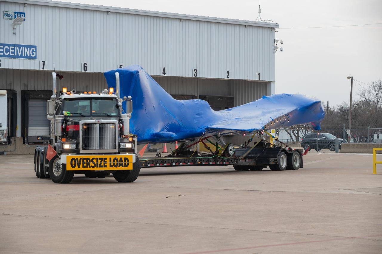
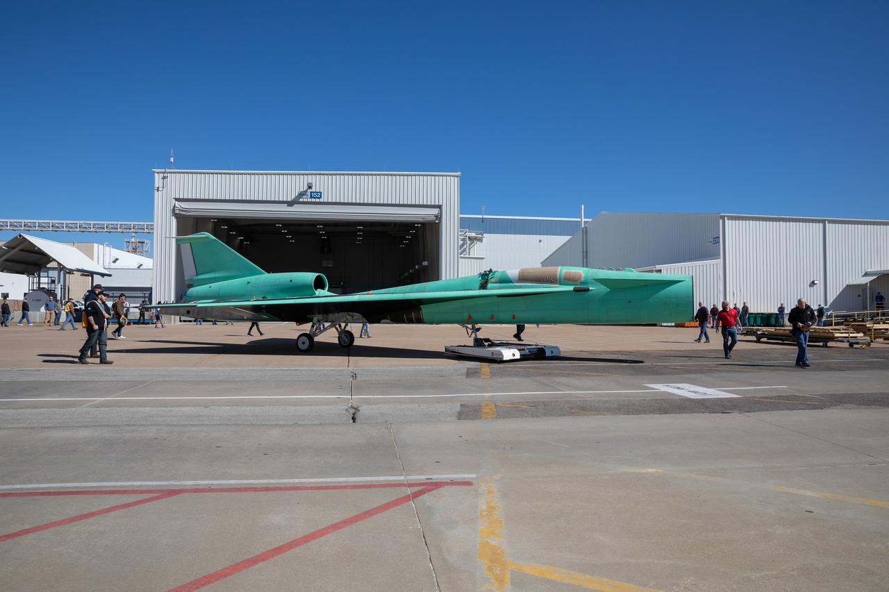
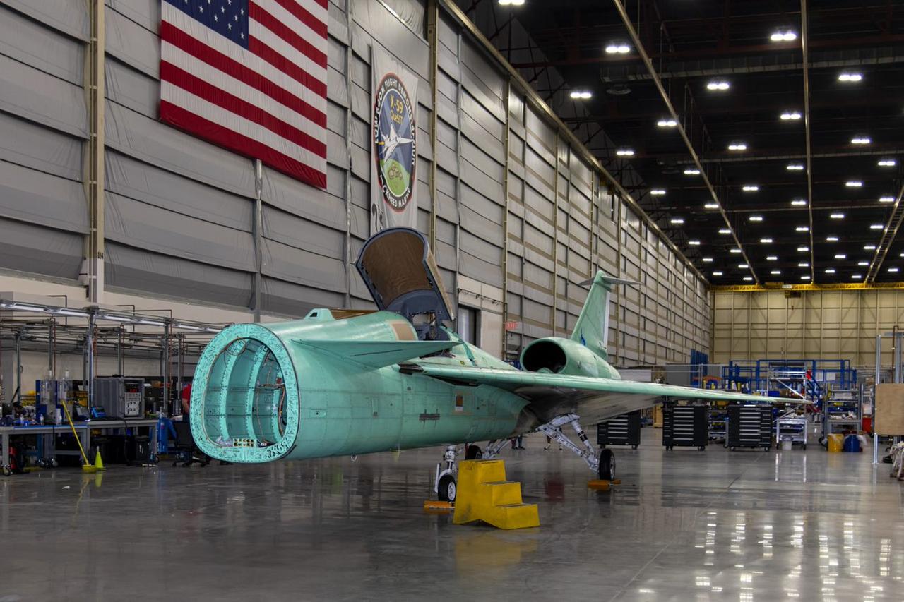
The X-59 arrives in Fort Worth, Texas from Palmdale, California, ready to undergo some important structural and fuel tests at the Lockheed Martin facility. The bright blue wrap around the X-plane is a precautionary measure to keep the exterior of the X-59 safe as it traveled through multiple states on its way to Texas.
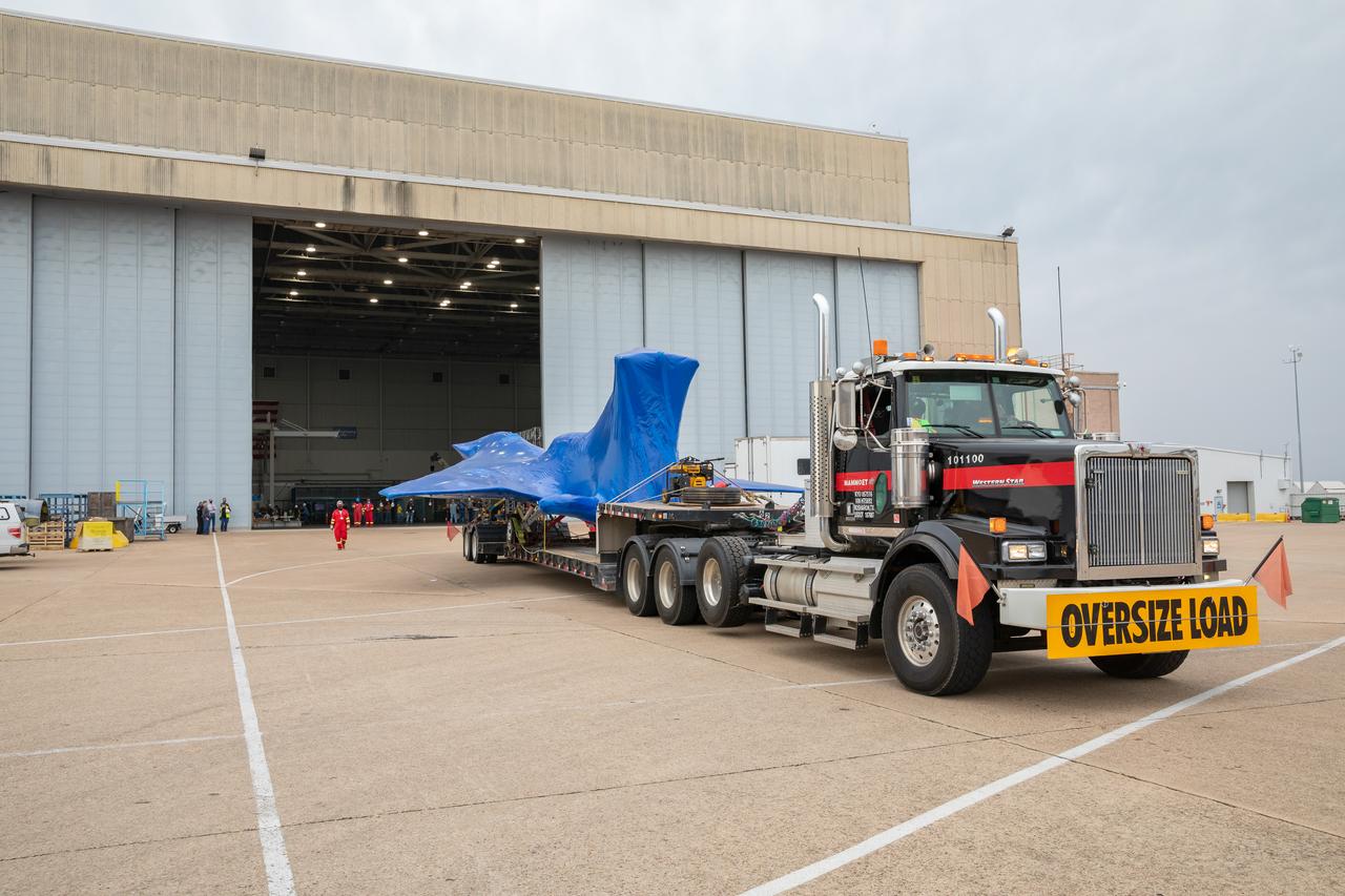
The X-59 arrives in Fort Worth, Texas from Palmdale, California, ready to undergo some important structural and fuel tests at the Lockheed Martin facility. The bright blue wrap around the X-plane is a precautionary measure to keep the exterior of the X-59 safe as it traveled through multiple states on its way to Texas.
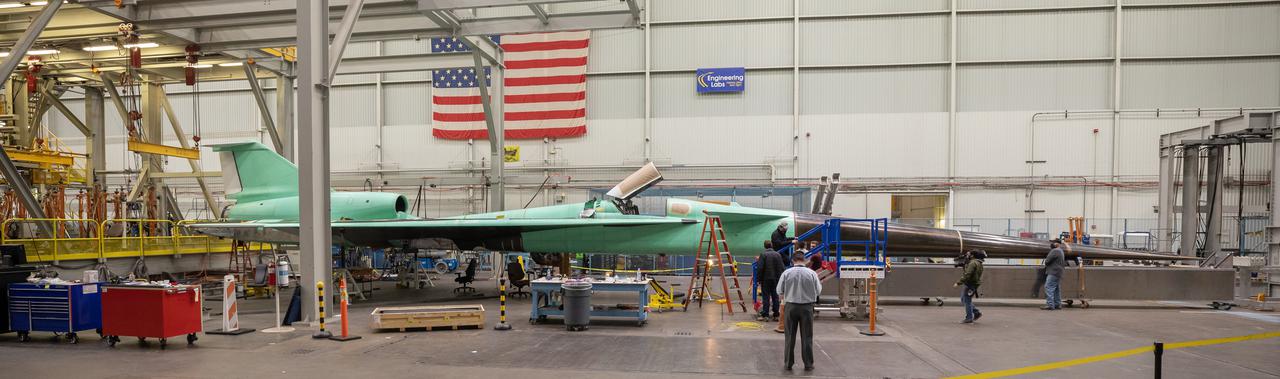
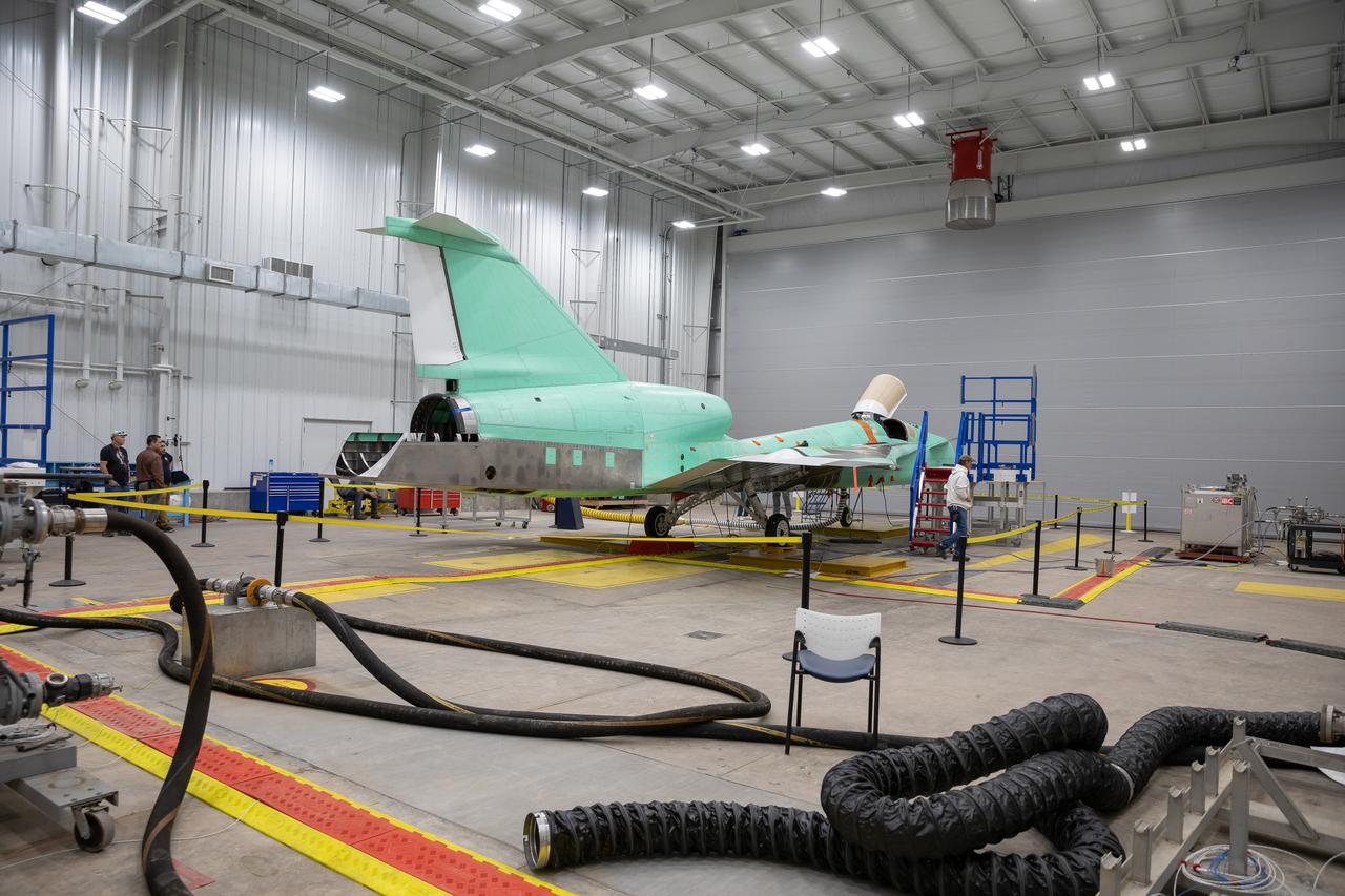
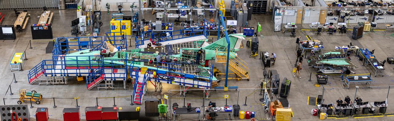
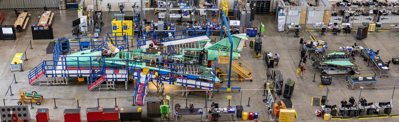
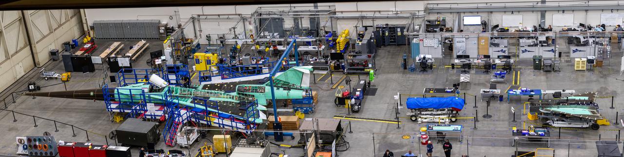
This panoramic side view of NASA’s X-59 Quiet SuperSonic Technology airplane shows the aircraft sitting on jacks at a Lockheed Martin test facility in Fort Worth, Texas. Lockheed Martin Aeronautics Company - Fort Worth - Chris Hanoch Subject: SEG 230 Nose Attachement FP#: 21-03420 POC: Analiese Smith, Chris Higgins Other info: X-59 in Fort Worth, testing
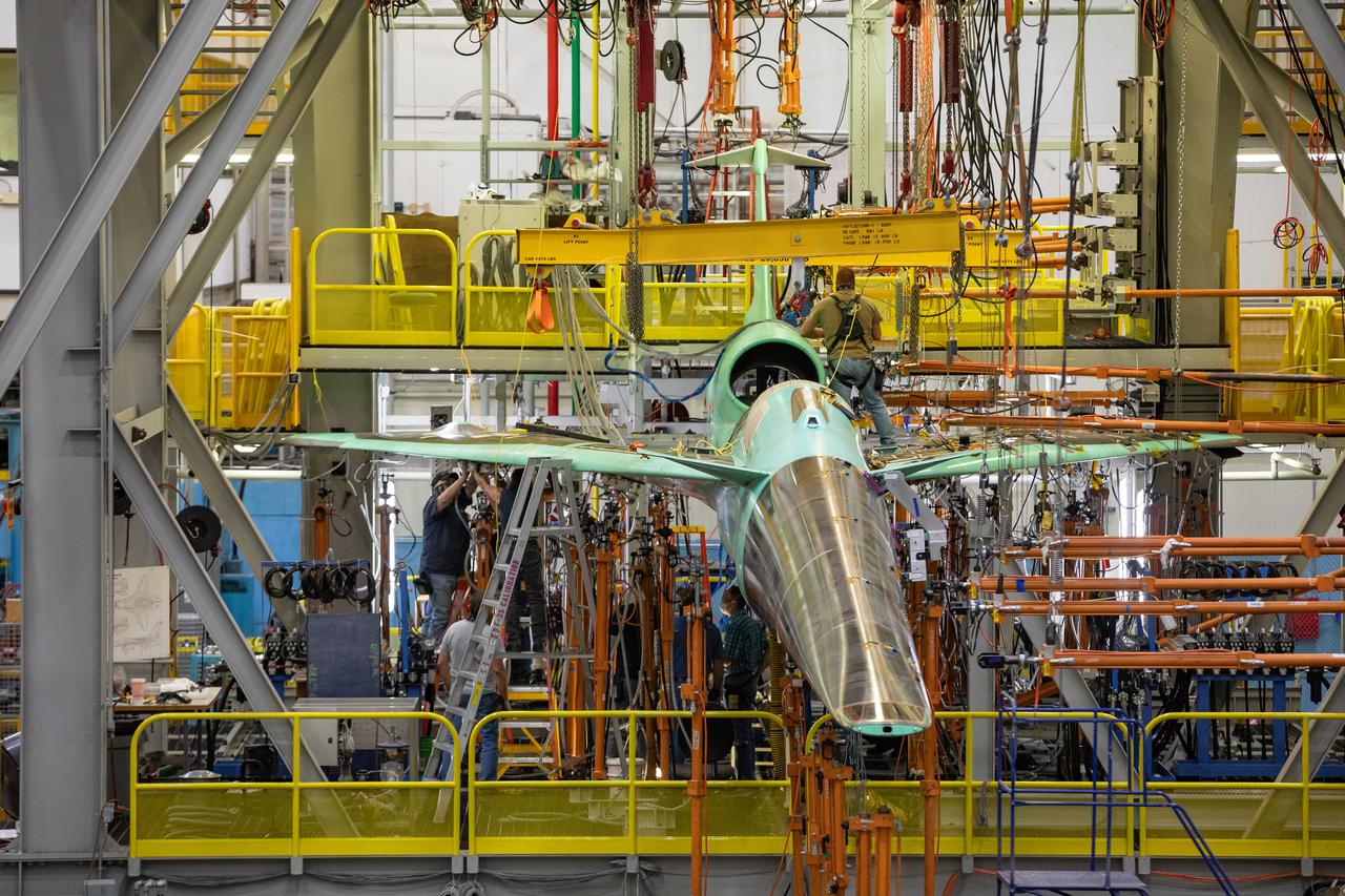
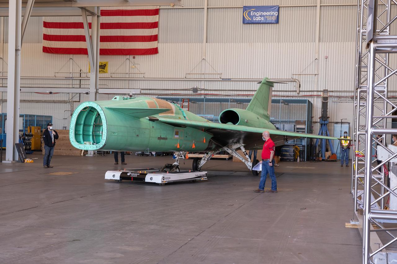
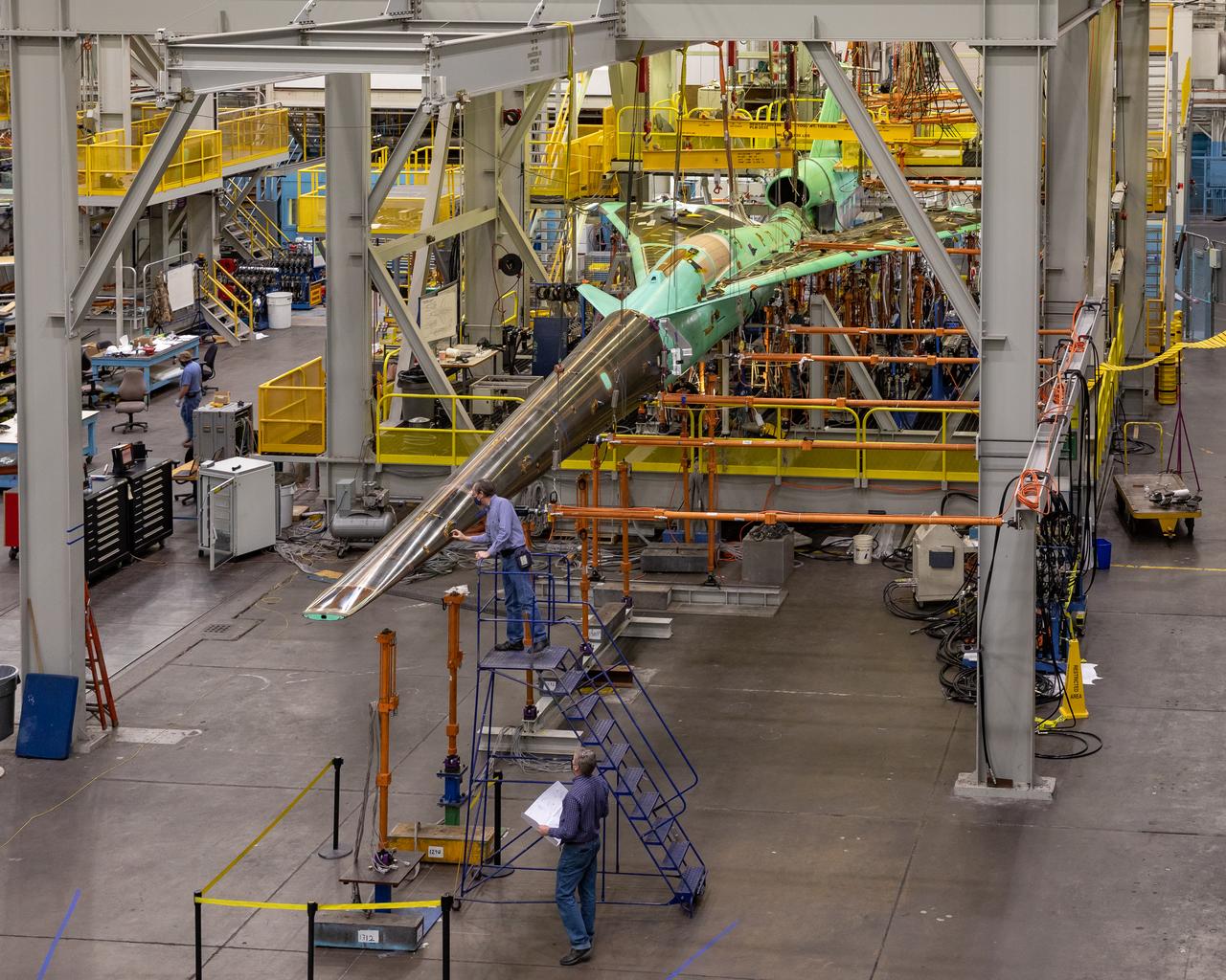
NASA’s X-59 Quiet SuperSonic Technology airplane undergoes structural stress tests at a Lockheed Martin facility in Fort Worth, Texas. Lockheed Martin Aeronautics Company - Fort Worth - Chris Hanoch Subject: X-59 - Various Angles in Test Fixture FP#: 21-03420 POC: Analiese Smith, Chris Higgins Other info: X-59 in Fort Worth, testing; high angle shots in fixture 1-10-22
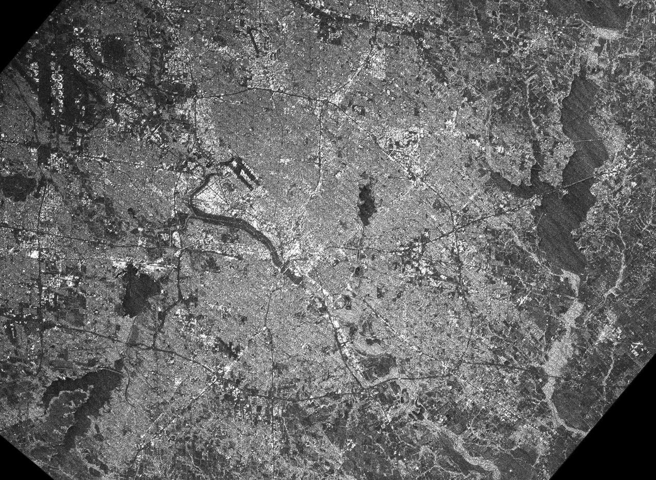
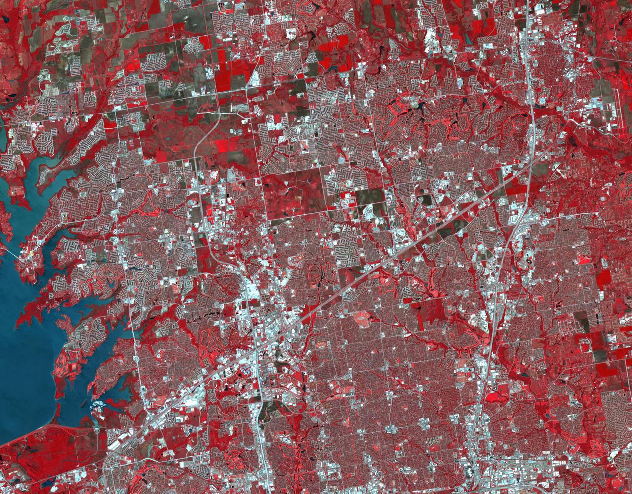
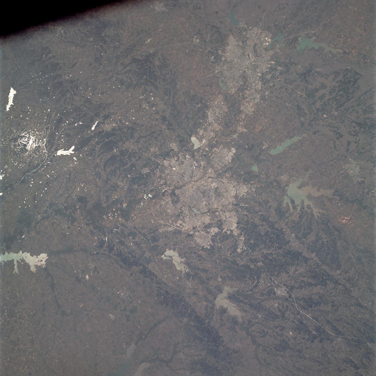
This radar image acquired by NASA Shuttle Radar Topography Mission SRTM from data collected on February 18, 2000 shows the Dallas-Fort Worth metropolitan area in Texas.
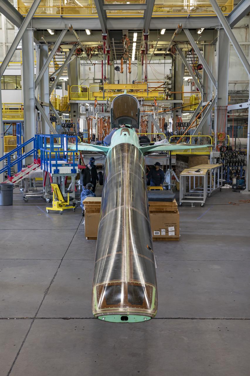
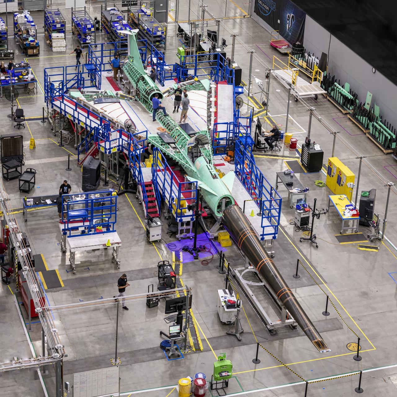
NASA’s X-59 undergoes a structural stress test at a Lockheed Martin facility in Fort Worth, Texas. The X-59’s nose makes up one third of the aircraft, at 38-feet in length. The X-59 is a one-of-a-kind airplane designed to fly at supersonic speeds without making aa startling sonic boom sound for the communities below. This is part of NASA’s Quesst mission which plans to help enable supersonic air travel over land
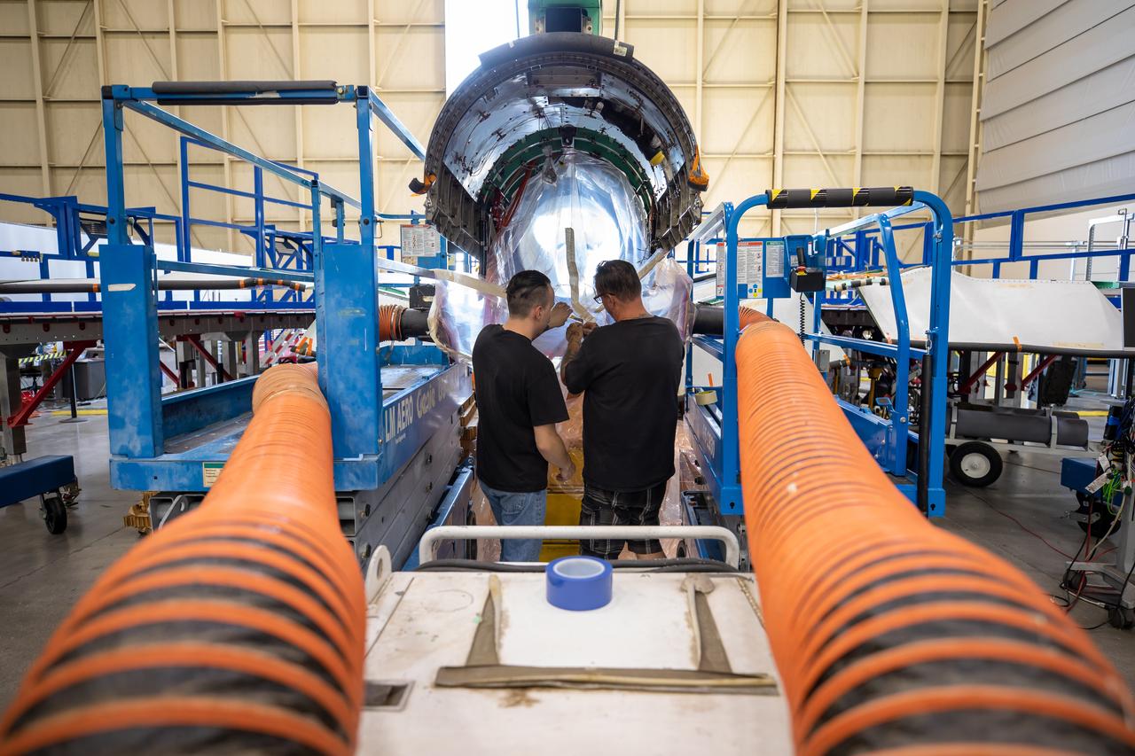
The X-59 is transported to the fuel barn at Lockheed Martin in Fort Worth, Texas to undergo fuel tank calibration tests. During this phase, the X-59’s gas tanks were filled and fuel-remaining sensors inside the aircraft were checked.
The X-59 sits in the fuel barn at Lockheed Martin in Fort Worth, Texas. While in the fuel barn, the X-59 underwent fuel tank calibration tests. During this phase, the X-59’s gas tanks were filled and fuel-remaining sensors inside the aircraft were checked.
The X-59 is transported to the fuel barn at Lockheed Martin in Fort Worth, Texas to undergo fuel tank calibration tests. During this phase, the X-59’s gas tanks were filled and fuel-remaining sensors inside the aircraft were checked.

AS06-02-1462 (4 April 1968) --- View of the Dallas-Fort Worth, Texas, area as photographed from the unmanned Apollo 6 (Spacecraft 020/Saturn 502) space mission. The highway and expressway system in and around both cities is clearly visible. North is toward left side of picture. Grapevine Reservoir and Garza-Little Elm Reservoir are to the north-west of Dallas. The city of Denton can be seen in left center of picture at conjunction of highways leading to both Fort Worth and Dallas. The Brazos River is in lower right corner. This photograph was made three hours and nine minutes after liftoff of the Apollo 6 space flight.

NASA's Ecosystem Spaceborne Thermal Radiometer Experiment on Space Station (ECOSTRESS) instrument recorded this image of ground surface temperatures in Dallas and Fort Worth, Texas, on June 20, 2022, at 7:17 a.m. Central Daylight Time. Even early in the day, manmade urban surfaces near city centers and transportation networks – streets, roads, and highways shown in red and orange – are warmer than the outskirts by up to 18 degrees Fahrenheit (10 degrees Celsius). The paved surfaces at Dallas/Fort Worth International Airport, shown in red near the top-center of the image, had the warmest temperatures, exceeding 86 F (30 C). Natural land surfaces such as vegetation and streams in rural areas, shown in green and blue, are cooler than nearby large bodies of water, shown in red and yellow, that tend to retain more heat overnight due to their higher heat capacity. Cities are usually warmer than open land because of human activities and the materials used in building and construction. Streets are often the hottest part of the built environment due to asphalt paving. Dark-colored surfaces absorb more heat from the Sun than lighter-colored ones; asphalt absorbs up to 95% of solar radiation and retains the heat for hours into the nighttime. ECOSTRESS measures the temperature of the ground, which is hotter than the air temperature during the daytime. The instrument launched to the space station in 2018. Its primary mission is to identify plants' thresholds for water use and water stress, giving insight into their ability to adapt to a warming climate. However, ECOSTRESS is also useful for documenting other heat-related phenomena, like patterns of heat absorption and retention. Its high-resolution images, with a pixel size of about 225 feet (70 meters) by 125 feet (38 meters), are a powerful tool for understanding our environment. https://photojournal.jpl.nasa.gov/catalog/PIA25422

NASA’s X-59 undergoes a structural stress test at Lockheed Martin’s facility at Fort Worth, Texas. The X-59 is a one-of-a-kind airplane designed to fly at supersonic speeds without making a startling sonic boom sound for the communities below. This is part of NASA’s Quesst mission, which plans to help enable supersonic air travel over land.
NASA’s X-59 undergoes a structural stress test at Lockheed Martin’s facility in Fort Worth, Texas. The X-59’s nose makes up one third of the aircraft, at 38-feet in length. The X-59 is a one-of-a-kind airplane designed to fly at supersonic speeds without making a startling sonic boom sound for the communities below. This is part of NASA’s Quesst mission, which plans to help enable supersonic air travel over land
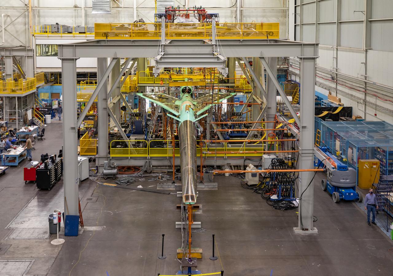
NASA’s X-59 undergoes a structural stress test at Lockheed Martin’s facility at Fort Worth, Texas. The X-59 is a one-of-a-kind airplane designed to fly at supersonic speeds without making a startling sonic boom sound for the communities below. This is part of NASA’s Quesst mission, which plans to help enable supersonic air travel over land.
Frisco, Texas is a city in the Dallas-Fort Worth metroplex, located about 40 km (24.9 mi) northeast of the Dallas/Fort Worth International Airport. Founded in 1860 along the Shawnee Trail, the town has become a bedroom community for workers in Dallas-Fort Worth. The city saw explosive growth between April 9, 1984 when the Landsat TM image was acquired, and April 15, 2018 when the ASTER image was acquired. Population grew from 4,500 to 174,000. The images cover an area of 27 by 34.5 km (16.7 by 21.4 mi), and are located at 33.1 degrees north, 96.8 degrees west. https://photojournal.jpl.nasa.gov/catalog/PIA22552
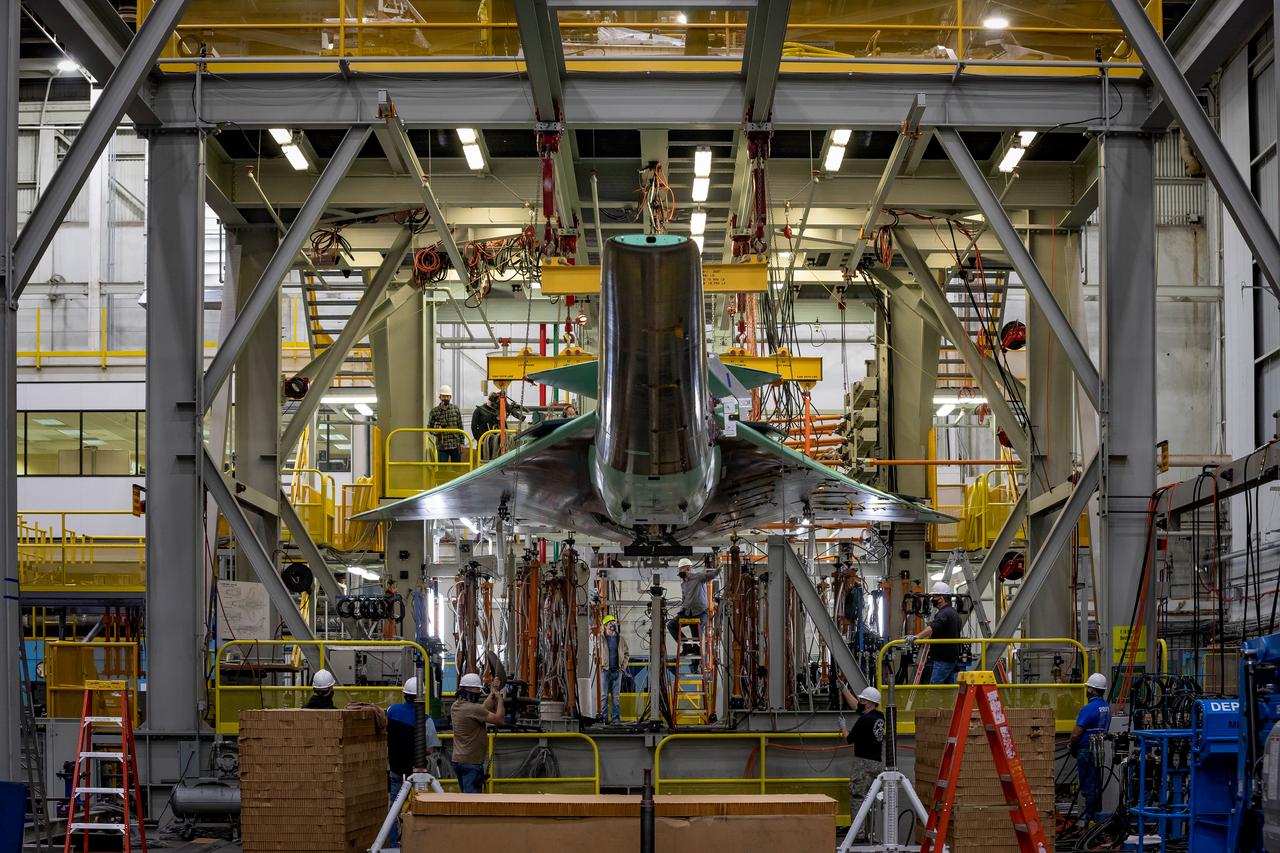
NASA’s X-59 is lowered into the test fixture as it prepares to undergo structural stress tests at Lockheed Martin in Fort Worth, Texas. The X-59 is a one-of-a-kind airplane designed to fly at supersonic speeds without making a startling sonic boom sound for the communities below. This is part of NASA’s Quesst mission which plans to help enable supersonic air travel over land.
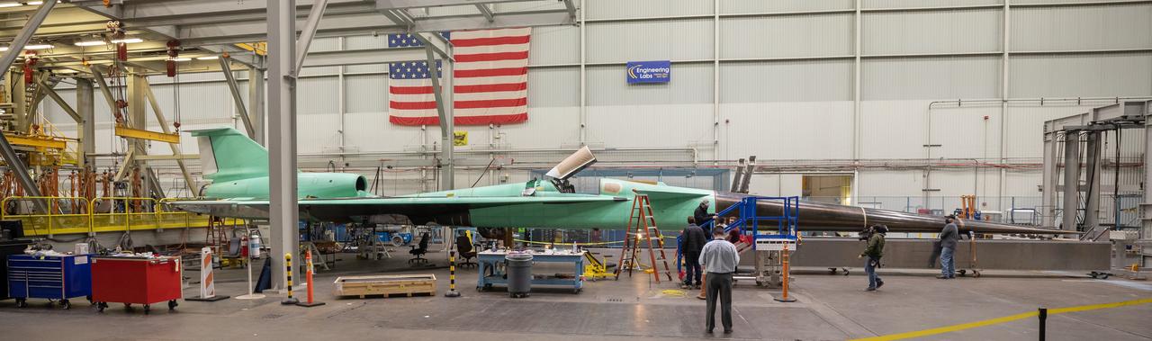
A panoramic view of NASA’s X-59 in Fort Worth, Texas to undergo structural and fuel testing. The X-59’s nose makes up one third of the aircraft, at 38-feet in length. The X-59 is a one-of-a-kind airplane designed to fly at supersonic speeds without making a startling sonic boom sound for the communities below. This is part of NASA’s Quesst mission which plans to help enable supersonic air travel over land.
AS09-21-3299 (3-13 March 1969) --- Dallas-Fort Worth area as photographed from the Apollo 9 spacecraft during its Earth-orbital mission. The superhighways leading out of two cities are clearly visible. The largest body of water north of Dallas is the Garza-Little Elm Reservoir. Cedar Creek Reservoir is located to the southeast of Dallas. The City of Denton is near left center edge of picture at junction of two highways leading from Fort Worth and Dallas.

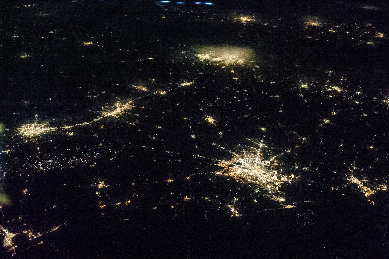
iss061e113495 (Jan. 3, 2020) --- The International Space Station was orbiting 260 miles above central Texas when this nighttime photograph was taken of the Dallas-Fort Worth metropolitan area.
STS039-85-032 (28 April-6 May 1991) --- A large portion of the Dallas - Fort Worth metropolitan area is seen in this 70mm frame, photographed from the Earth-orbiting Space Shuttle Discovery. Hold photograph with the Dallas - Ft. Worth Airport directly above the center point of the picture so that north will be at the top. Compared with Apollo 6 pictures made 23 years earlier (April 1968), this photo indicates notable growth in the municipalities between Dallas and Ft. Worth as well as great outer growth of the two cities. (Most of the western portions of Ft. Worth did not make it into this frame). Easily recognizable bodies of water are Grapevine Lake and North Lake (both near the huge airport), Mountain Creek Lake (southwest of Dallas), Lake Arlington (southeast of Ft. Worth) and the Trinity River which flows southward to the Gulf of Mexico.
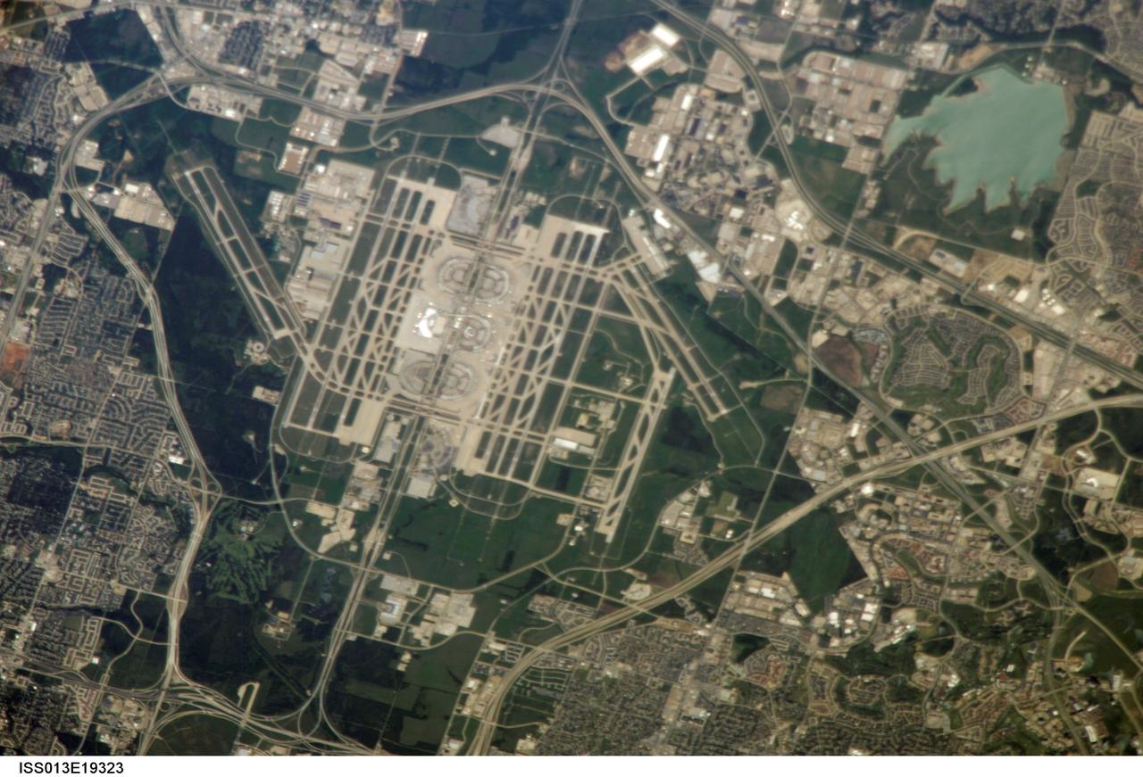
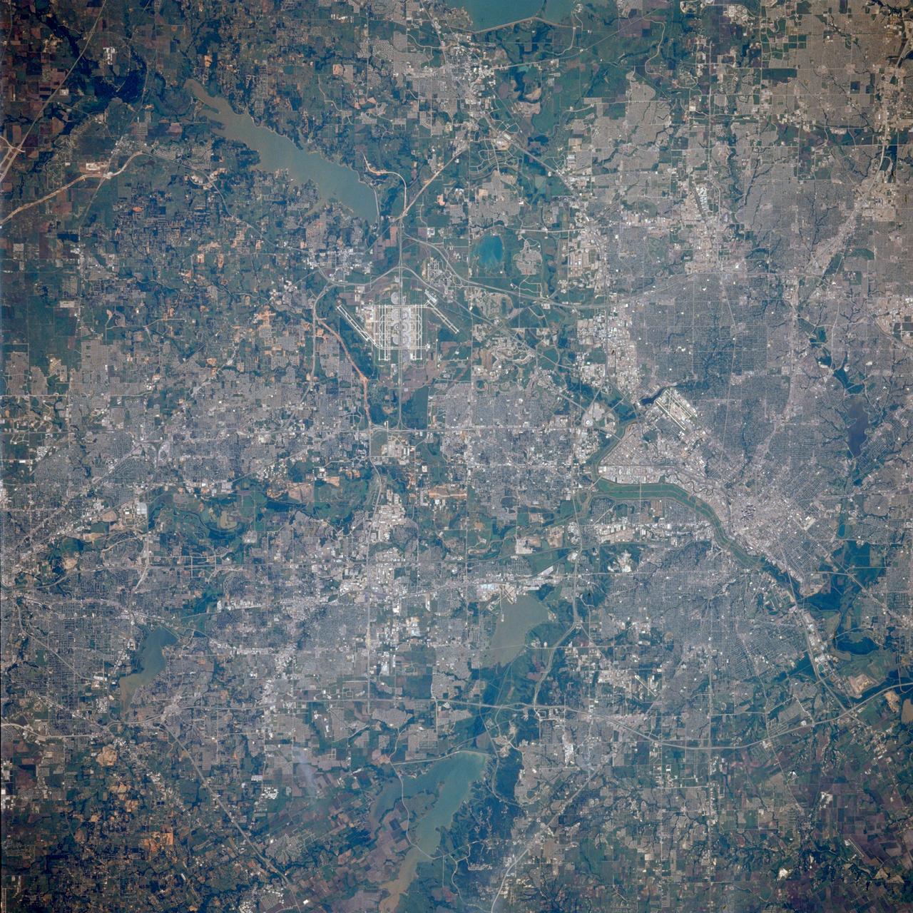
ISS013-E-19323 (13 May 2006) --- The largest airport in Texas, Dallas-Fort Worth (DFW) International Airport, is featured in this image photographed by an Expedition 13 crewmember on the International Space Station. DFW is also the fourth largest in the world, and occupies more surface area than the entire island of Manhattan in New York. The airport is officially owned by the cities of Dallas and Fort Worth, but is sited within the city limits of four neighboring cities (Coppell, Euless, Grapevine, and Irving). This oblique image captures the entire airport and portions of the surrounding Dallas-Forth Worth metropolitan area. The white rooftops of the new - completed in 2005 - International Terminal D are also distinct from less reflective rooftops of the older terminals. A sense of the size of the airport is provided by the approximately 2,800 meters long northwest-southeast oriented runway to the west of Terminal D. The oblique viewing angle also accentuates light reflection off of North Lake (image upper right), giving the water surface a grey-green cast.
iss061e067843 (Dec. 6, 2019) --- The Dallas-Fort Worth, Texas metropolitan area is pictured along with such landmarks as DFW International Airport and Dallas Love Field Airport from an altitude of 258 miles. Several bodies of water are pictured including Joe Pool Lake, Mountain Creek Lake, White Rock Lake, Lake Ray Hubbard, Lewisville Lake and Grapevine Lake among others.

ISS010-E-24596 (14 April 2005) --- Dallas, Texas is featured in this image photographed by an Expedition 10 crew member on the International Space Station. The Dallas-Fort Worth metropolitan area is the largest in Texas with an approximate population of 6 million people in 2005. Founded by John Neely Bryan in 1841, the city became the center for the United States oil economy with the discovery of oilfields to the east of the city in 1930. The Dallas-Forth Worth region today is a major corporate, banking, and technological center. This image captures the northwestern portion of the metropolitan area. Standing water bodies such as Lake Lewisville and Grapevine Lake are highlighted by sunglint, where the surface of the water acts as a mirror reflecting sunlight back towards the astronauts on the Station. Using the sunglint to define edges of water helps when mapping water bodies and stream courses on a landscape ? note the region of small ponds to the north of Grapevine Lake highlighted by sunglint. Photo credit: NASA

ISS025-E-010008 (29 Oct. 2010) --- From 220 miles above Earth, one of the Expedition 25 crew members onboard the International Space Station shot this night time image of the northern Gulf coast. Mobile Bay and the city of Mobile (top left, beneath one of the solar panels of a docked Russian Soyuz spacecraft), New Orleans and Houston are visible as the view ?moves? southeastward. The Interstate Highway 20 cities of Jackson, Shreveport, Dallas and Fort Worth are also visible further inland. The view extends northward (left) to Little Rock and Oklahoma City.
The X-59 arrives home in Palmdale, California after completing important structural and fuel tests at the Lockheed Martin facility in Ft. Worth, Texas. The nose, which is not installed in this image, was removed prior to the transport home and arrived separately to the facility. This is part of NASA’s Quesst mission which plans to help enable supersonic air travel over land.

ISS033-E-021663 (15 Nov. 2012) --- A nighttime view of the Dallas, Texas metropolitan area is featured in this image photographed by an Expedition 33 crew member on the International Space Station. Most metropolitan areas of the western United States are configured over large areas with a regular street grid pattern that is highly recognizable from space, particularly at night. The northern Dallas metropolitan area exhibits this pattern. The north-south and east-west grid pattern of major surface streets is highlighted by orange street lighting, lending a fishnet-like appearance to the urban area. Within this framework, smaller residential and commercial buildings and streets give green-gray stipple patterns to some blocks. The airplane terminals of Dallas-Fort Worth International Airport are lit with golden-yellow lights, and surrounded by relatively dark runways and fields at left. Likewise, the runways of Dallas Love Field at lower center are recognizable by their darkness. Other dark areas within the metro region are open space, parks, and water bodies. Dallas is part of the larger Dallas-Fort Worth-Arlington Metropolitan Statistical Area (population 6,526,548 in 2011) as recognized by the U.S. Census Bureau; to most Texans, it is simply ?DFW? or ?the Metroplex.? Several of the larger urban areas within DFW are visible in this image; Dallas, Garland and Richardson all have populations above 100,000 according to the North Central Texas Council of Governments. While historically the economy of Dallas was based in the oil and cotton industries, today commerce, technology, healthcare, and transportation are the major economic drivers.
The X-59 Quiet SuperSonic Technology (QueSST) aircraft is taking shape at the Lockheed Martin Skunk Works facility in Palmdale, California. The team positioned the X-59 QueSST's nose at the front of the aircraft. As one of the more recognizable features of the X-59, the nose makes up almost a third of the aircraft length and will be essential in shaping shock waves during supersonic flight, resulting in quiet sonic thumps instead of loud sonic booms. The nose was attached and then removed from the front of the aircraft in preparation for its shipment to Fort Worth, Texas where it will undergo additional testing. The X-59 will fly at supersonic speeds above communities as part of the Low-Boom Flight Demonstration mission, during which NASA will gather community feedback to the sound of quiet supersonic flight. These findings will be shared with regulators to inform decisions on current restrictions of supersonic flight over land. Lockheed Martin Photography By Garry Tice 1011 Lockheed Way, Palmdale, Ca. 93599 Event: Manufacturing Area From Above Date: 8/18/2021 Additional Info:
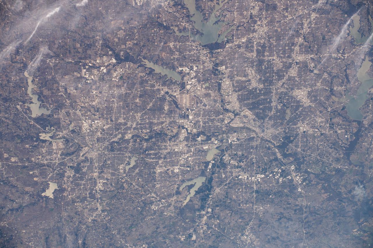
ISS036-E-009405 (17 June 2013) --- One of the Expedition 36 crew members aboard the International Space Station, some 240 miles above Earth, used a 50mm lens to record this oblique nighttime image of a large part of the nation’s second largest state in area, including the four largest metropolitan areas in population. The extent of the metropolitan areas is easily visible at night due to city and highway lights. The largest metro area, Dallas-Fort Worth, often referred to informally as the Metroplex, is the heavily cloud-covered area at the top center of the photo. Neighboring Oklahoma, on the north side of the Red River, less than 100 miles to the north of the Metroplex, appears to be experiencing thunderstorms. The Houston metropolitan area, including the coastal city of Galveston, is at lower right. To the east near the Texas border with Louisiana, the metropolitan area of Beaumont-Port Arthur appears as a smaller blotch of light, also hugging the coast of the Texas Gulf. Moving inland to the left side of the picture one can delineate the San Antonio metro area. The capital city of Austin can be seen to the northeast of San Antonio. This and hundreds of thousands of other Earth photos taken by astronauts and cosmonauts over the past 50 years are available on http://eol.jsc.nasa.gov

A Lockheed Martin technician works to complete wiring on the X-59 aircraft in preparation for the power-on system checkouts. Once complete, the X-59 aircraft will demonstrate the ability to fly supersonic while reducing the loud sonic boom to a quiet sonic thump and help enable commercial supersonic air travel over land. This aircraft is the centerpiece of NASA’s Quesst mission.
This overhead view of the X-59 shows the aircraft’s current state of assembly at Lockheed Martin Skunk Works in Palmdale, California. Throughout the manufacturing process, the team often removes components to effectively and safely assemble other sections of the aircraft. The X-59’s horizontal tails and lower empennage were recently removed from the aircraft and can be seen behind it as the team prepares for the installation of the engine. The X-59 is the centerpiece of the Quesst mission which plans to help enable commercial supersonic air travel over land.
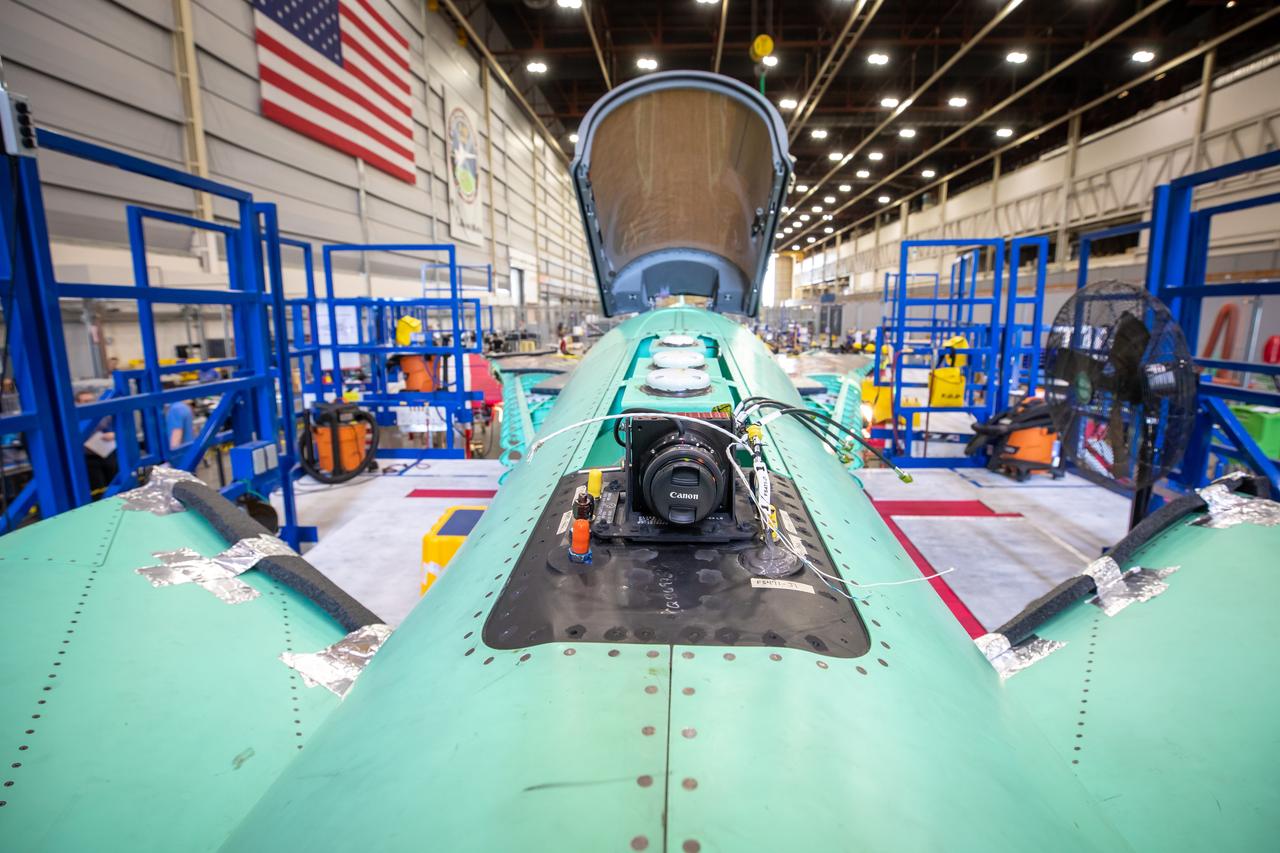
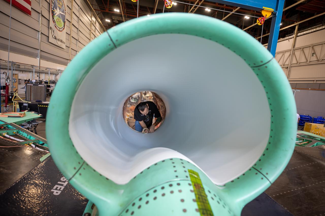
Event: Horizontal Stabilator Install A close up of the camera from the X-59’s eXternal Vision System. This camera is on the top of the X-59, but there will also be one on the belly of the aircraft. This visuals from this camera will be displayed on a 4K monitor for the pilot. As part of the supersonic shaping technology, the X-plane will not have a forward-facing window in the cockpit.
This overhead view of the X-59 shows the aircraft at Lockheed Martin Skunk Works in Palmdale, California. During the assembly of this experimental aircraft, the team often has to remove components to effectively and safely assemble other sections of the aircraft. In this image, the nose is not attached and the horizontal stabilators are shown behind the tail. The X-59 is the centerpiece of NASA’s Quesst mission which plans to produce data that will help enable commercial supersonic air travel over land.
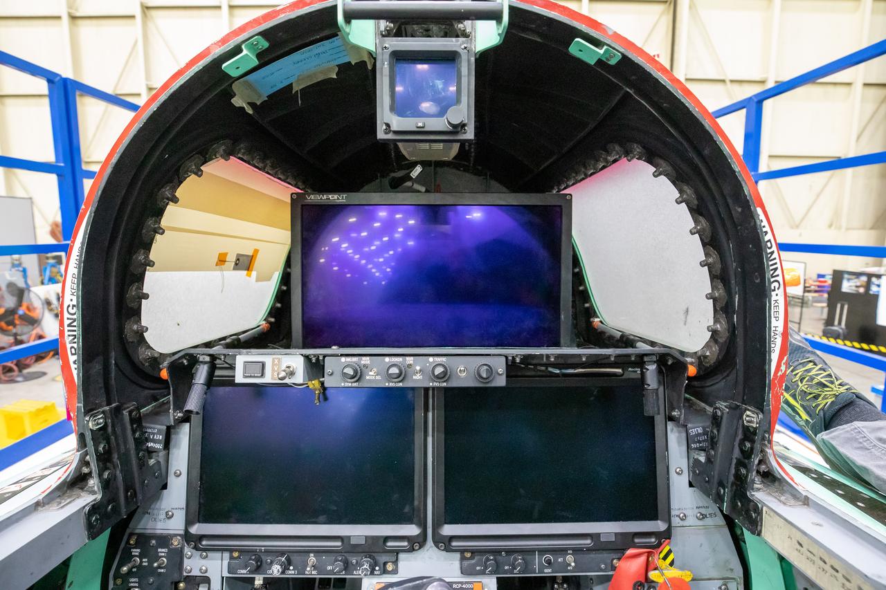
This image shows the forward view of the X-59’s cockpit with the canopy open. The aircraft will not have a forward-facing window and will use an eXternal Vision System (XVS) made up of a high definition 4K monitor (located in the center) and two monitors below to help the pilots safely fly through the skies.
Here is an overhead view of the X-59 aircraft (left) prior to the installation of the General Electric F414 engine (center, located under the blue cover). After the engine is installed, the lower empennage (right), the last remaining major aircraft component, will be installed in preparation for integrated system checkouts. The X-59 is the centerpiece of the Quesst mission which plans to help enable commercial supersonic air travel over land.

This overhead view of the X-59 shows the aircraft at Lockheed Martin Skunk Works in Palmdale, California. During the assembly of this experimental aircraft, the team often has to remove components to effectively and safely assemble other sections of the aircraft. In this image, the nose is not attached and the horizontal stabilators are shown behind the tail. The X-59 is the centerpiece of NASA’s Quesst mission which plans to produce data that will help enable commercial supersonic air travel over land.
This is an up-close view of the X-59’s engine inlet – fresh after being painted. The 13-foot F414-GE-100 engine will be placed inside the inlet bringing the X-59 aircraft one step closer to completion. Once fully assembled, the X-59 aircraft will begin flight operations, working toward demonstration of the ability to fly supersonic while reducing the loud sonic boom to a quiet sonic thump, helping to enable commercial supersonic air travel over land.
This image shows the extensive ventilation system that has been placed adjacent to the X-59 during the recent painting of the aircraft’s engine inlet. Once the aircraft build and ground testing are complete, the X-59 airplane will begin flight testing, working towards demonstrating the ability to fly supersonic while reducing the loud sonic boom to a quiet sonic thump and help enable commercial supersonic air travel over land.
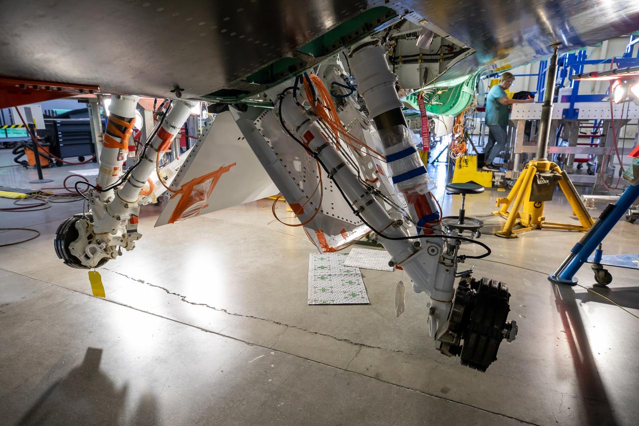
The Quesst team has repurposed the landing gear from an F-16 Fighting Falcon aircraft and is working on adjusting the fit onto the X-59 airplane. This is part of NASA’s Quesst mission which plans to help enable commercial supersonic air travel over land.