Footprints from Above

Daybreak From Above
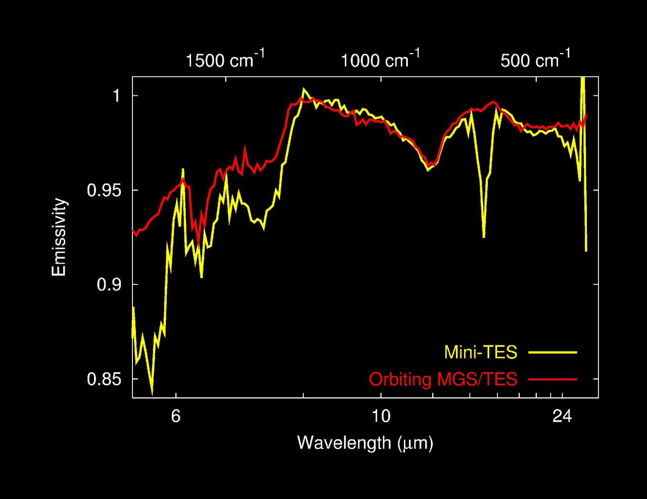
Dust Spectra from Above and Below
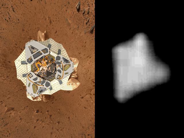
View from above Landing Site
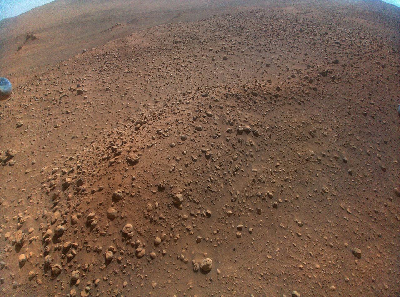
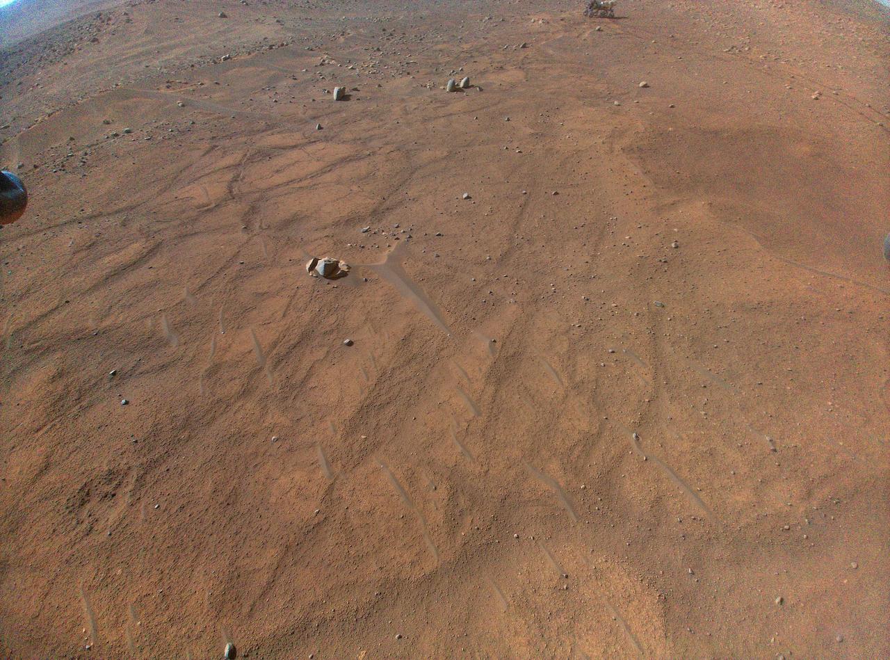
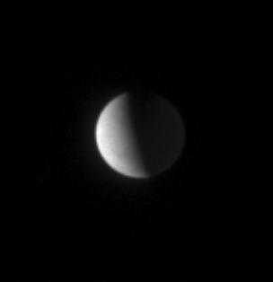
View From Above Spirit on Mars
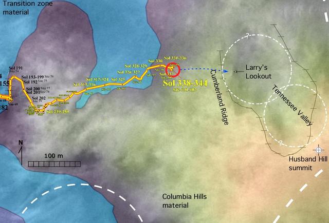
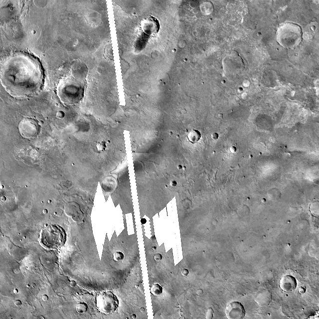
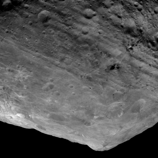
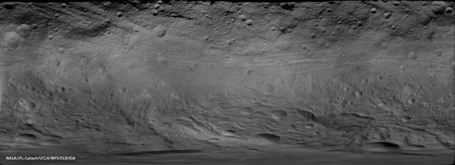
Gusev Crater Geology as Seen from Above
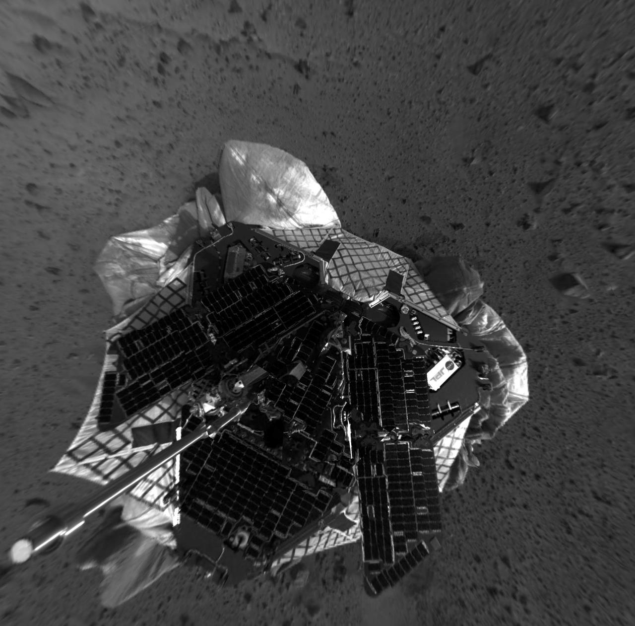
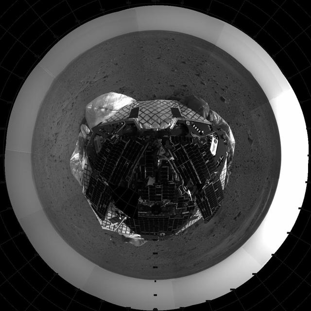
View From Above Spirit on Mars-2

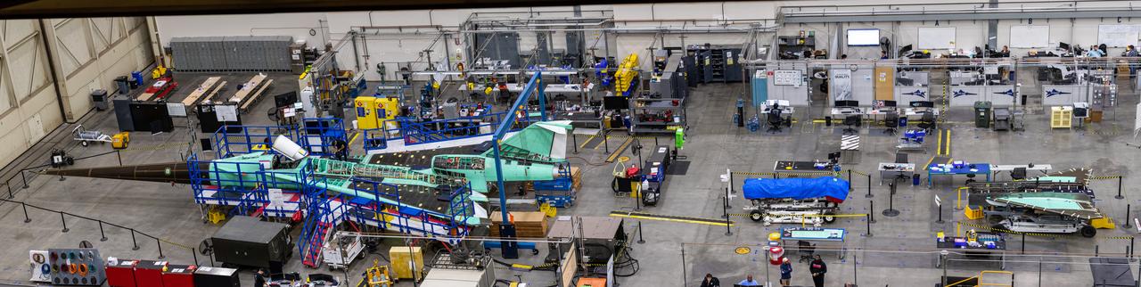
This overhead shot of the X-59 assembly during Spring 2021 shows assembly with technicians working at the engine inlet section where the engine will be located on the aircraft. Lockheed Martin Photography By Garry Tice 1011 Lockheed Way, Palmdale, Ca. 93599 Event: Manufacture Area From Above Date: 3/30/2021

This overview shot of the X-59 Quiet Supersonic Technology or QueSST aircraft shows the vehicle before a major merger of three major aircraft sections – the fuselage, the wing, and the tail assembly – together, making it looks more like an airplane. Lockheed Martin Photography By Garry Tice 1011 Lockheed Way, Palmdale, Ca. 93599 Event: Manufacture Area From Above Date: 3/30/2021

Event: Manufacturing Area From Above A overhead view of the X-59 with its nose on. The X-59’s nose is 38-feet long – approximately one third of the length of the entire aircraft. The aircraft, under construction at Lockheed Martin Skunk Works in Palmdale, California, will demonstrate the ability to fly supersonic while reducing the loud sonic boom to a quiet sonic thump.

This overhead shot of the X-59 Quiet SuperSonic Technology or QueSST aircraft shows the assembly progress of the vehicle during Spring 2021. Pictured here you can see the nose (far left) which will later be mounted to the middle section in the photo known as the fuselage and the last section is the wing and tail in the far right of the photo. Lockheed Martin Photography By Garry Tice 1011 Lockheed Way, Palmdale, Ca. 93599 Event: Manufacture Area From Above Date: 3/30/2021

This overhead shot of the X-59 Quiet SuperSonic Technology or QueSST aircraft shows the assembly progress of the vehicle during Spring 2021. In the left side of the picture, the fuselage which contains the cockpit is shown and the right side of the photo shows the wing and the tail section of the aircraft. Lockheed Martin Photography By Garry Tice 1011 Lockheed Way, Palmdale, Ca. 93599 Event: Manufacture Area From Above Date: 3/30/2021

The X-59 Quiet SuperSonic Technology (QueSST) aircraft is taking shape at the Lockheed Martin Skunk Works facility in Palmdale, California. The team positioned the X-59 QueSST's nose at the front of the aircraft. As one of the more recognizable features of the X-59, the nose makes up almost a third of the aircraft length and will be essential in shaping shock waves during supersonic flight, resulting in quiet sonic thumps instead of loud sonic booms. The nose was attached and then removed from the front of the aircraft in preparation for its shipment to Fort Worth, Texas where it will undergo additional testing. The X-59 will fly at supersonic speeds above communities as part of the Low-Boom Flight Demonstration mission, during which NASA will gather community feedback to the sound of quiet supersonic flight. These findings will be shared with regulators to inform decisions on current restrictions of supersonic flight over land. Lockheed Martin Photography By Garry Tice 1011 Lockheed Way, Palmdale, Ca. 93599 Event: Manufacturing Area From Above Date: 8/18/2021 Additional Info:

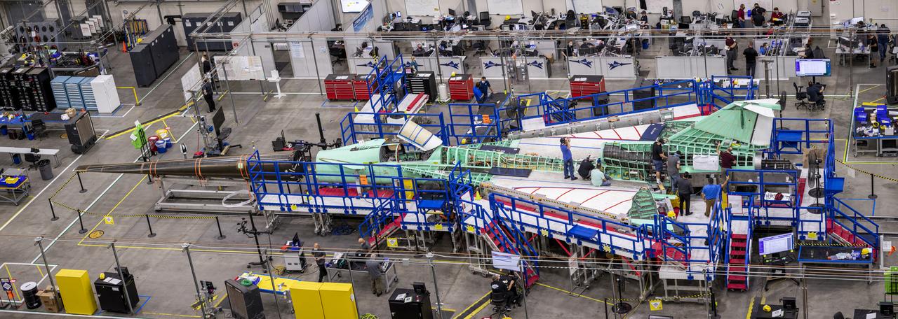
Pictured here is an overhead view of the X-59 as it comes together for the major assembly merger in summer 2021. Lockheed Martin Photography By Garry Tice 1011 Lockheed Way, Palmdale, Ca. 93599 Event: Manufacturing Area From Above Date: 5/26/2021
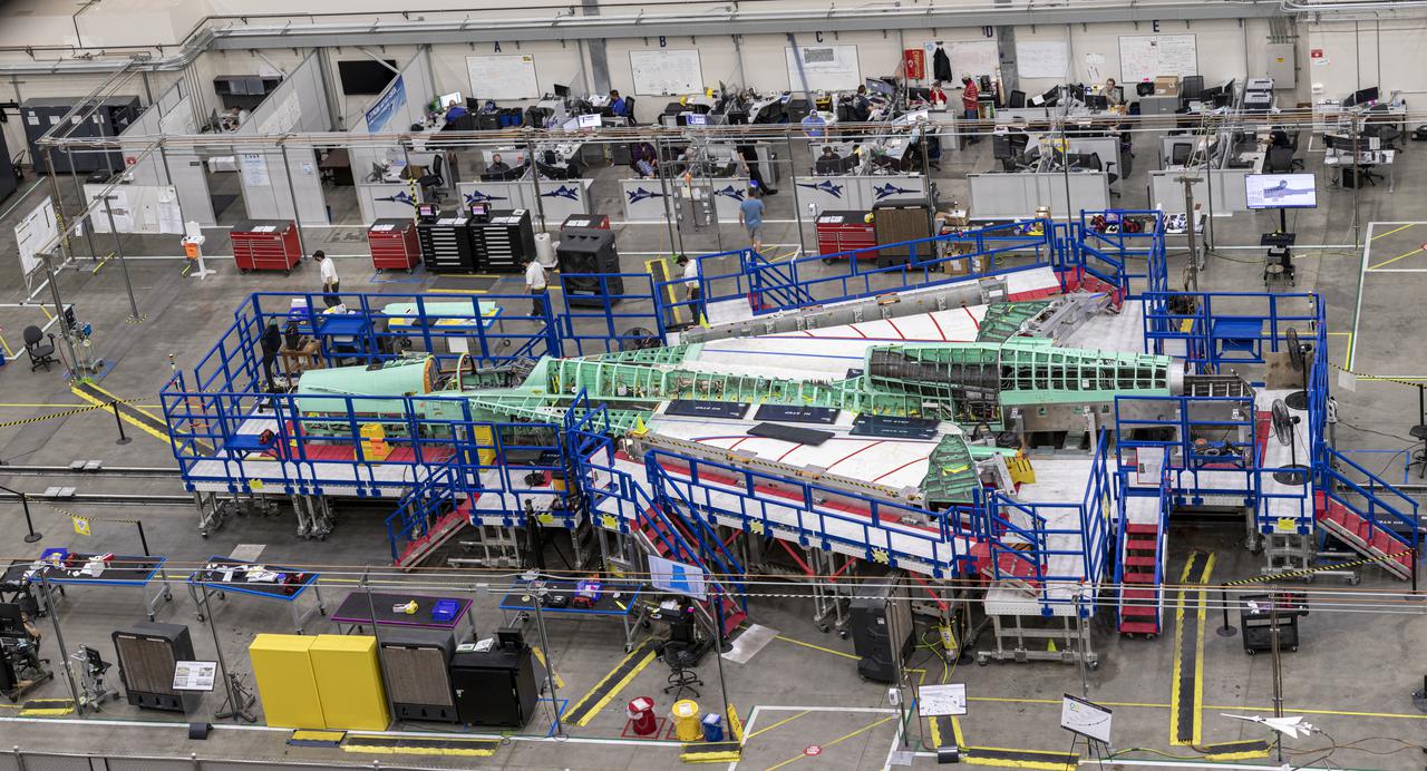
Pictured is an overhead view of the X-59 as it comes together for the major assembly merger in summer 2021. Lockheed Martin Photography By Garry Tice 1011 Lockheed Way, Palmdale, Ca. 93599 Event: Manufacturing Area From Above Date: 5/26/2021

This overhead view shows NASA’s X-59 Quiet SuperSonic Technology or QueSST aircraft as it comes together for the merger of its main parts – the wing, forward section and tail assembly. Lockheed Martin Photography By Garry Tice 1011 Lockheed Way, Palmdale, Ca. 93599 Event: Manufacturing Area From Above Date: 5/26/2021
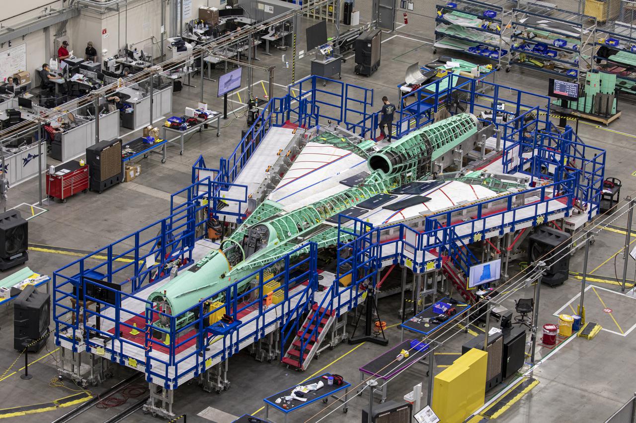
The team at Lockheed Martin Skunk Works in Palmdale, California, merged the major sections of the X-59 Quiet SuperSonic Technology aircraft, which includes the wing, tail assembly, and fuselage or forward section. This marks the first time the X-59 resembles an actual aircraft. (Pictured here is a overhead view of the X-59 as it comes together for the major assembly merger in summer 2021.) Lockheed Martin Photography By Garry Tice 1011 Lockheed Way, Palmdale, Ca. 93599 Event: Manufacturing Area From Above Date: 5/26/2021
A panoramic side view of the left top of the X-59 supersonic plane with the tail on and the nose in the process of installation. The X-59’s nose is 38-feet long – approximately one third of the length of the entire aircraft. The aircraft, under construction at Lockheed Martin Skunk Works in Palmdale, California, will demonstrate the ability to fly supersonic while reducing the loud sonic boom to a quiet sonic thump.

A overhead view of the X-59 with its nose on. The X-59’s nose is 38-feet long – approximately one third of the length of the entire aircraft. The plane is under construction at Lockheed Martin Skunk Works in Palmdale, California, will fly to demonstrate the ability to fly supersonic while reducing the loud sonic boom to a quiet sonic thump.

An overhead view of the X-59 supersonic plane with the tail on and the nose in the process of installation. The X-59’s nose is 38-feet long – approximately one third of the length of the entire aircraft. The aircraft, under construction at Lockheed Martin Skunk Works in Palmdale, California, will demonstrate the ability to fly supersonic while reducing the loud sonic boom to a quiet sonic thump.

This artist's concept shows a view from above the Lunar Flashlight spacecraft, a six-unit CubeSat designed to search for ice on the Moon's surface using special lasers. The spacecraft uses its near-infrared lasers to shine light into shaded polar regions on the Moon, while an on-board reflectometer measures surface reflection and composition. https://photojournal.jpl.nasa.gov/catalog/PIA23132
This artist image of an imaginary camera zooming in from above shows the location of the Robotic Arm Camera on NASA Phoenix Mars Lander as it acquires an image of the scoop at the end of the arm
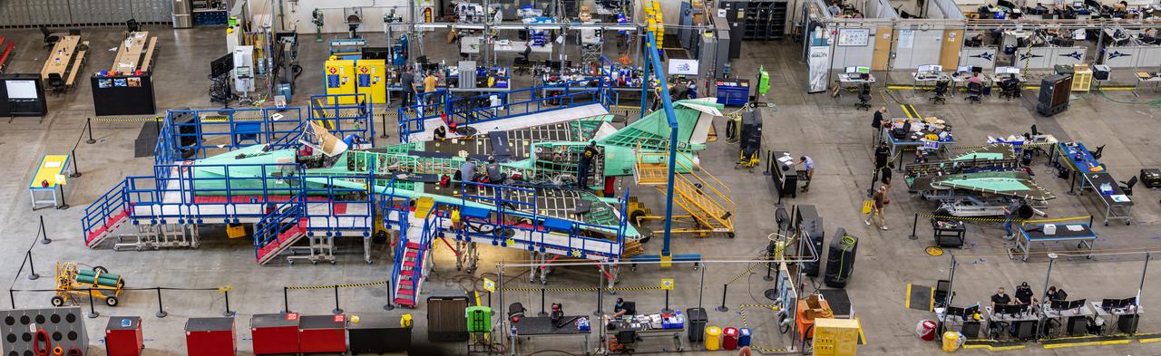
This overhead view of the X-59 shows the aircraft at Lockheed Martin Skunk Works in Palmdale, California. During the assembly of this experimental aircraft, the team often has to remove components to effectively and safely assemble other sections of the aircraft. In this image, the nose is not attached and the horizontal stabilators are shown behind the tail. The X-59 is the centerpiece of NASA’s Quesst mission which plans to produce data that will help enable commercial supersonic air travel over land.
Here is an overhead view of the X-59 aircraft (left) prior to the installation of the General Electric F414 engine (center, located under the blue cover). After the engine is installed, the lower empennage (right), the last remaining major aircraft component, will be installed in preparation for integrated system checkouts. The X-59 is the centerpiece of the Quesst mission which plans to help enable commercial supersonic air travel over land.

This overhead view of the X-59 shows the aircraft at Lockheed Martin Skunk Works in Palmdale, California. During the assembly of this experimental aircraft, the team often has to remove components to effectively and safely assemble other sections of the aircraft. In this image, the nose is not attached and the horizontal stabilators are shown behind the tail. The X-59 is the centerpiece of NASA’s Quesst mission which plans to produce data that will help enable commercial supersonic air travel over land.

This is an overhead view of the X-59 aircraft at Lockheed Martin Skunk Works in Palmdale, California. The nose was installed, and the plane awaits engine installation. Technicians continue to wire the aircraft as the team preforms several system checkouts to ensure the safety of the aircraft. The X-59 aircraft will demonstrate the ability to fly supersonic while reducing the loud sonic boom to a quiet sonic thump and help enable commercial supersonic air travel over land.
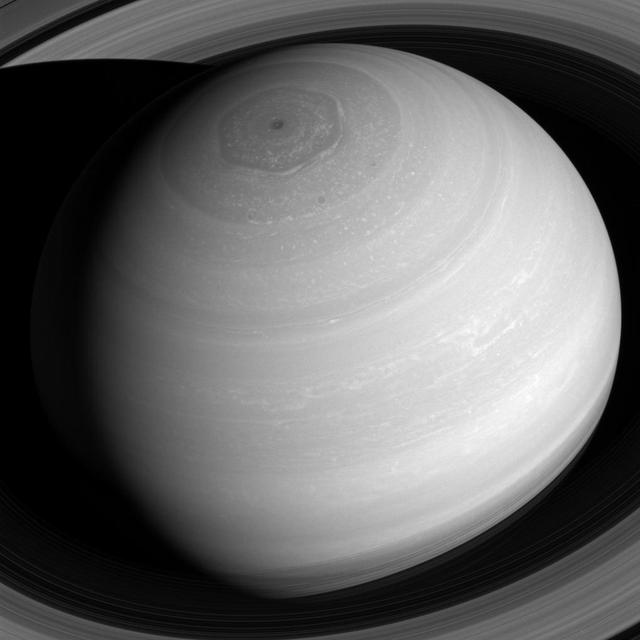
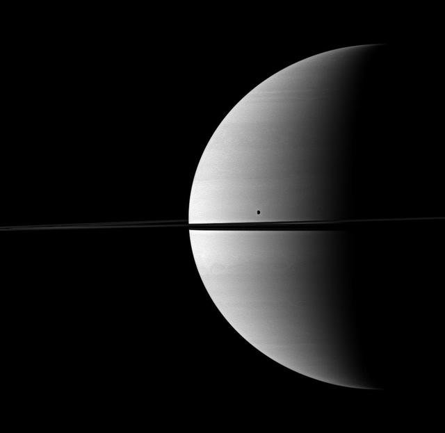
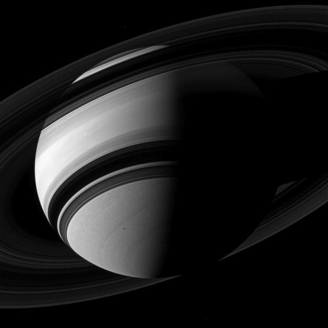
Saturn appears as a serene globe amid tranquil rings in this view from NASA's Cassini spacecraft. In reality, the planet's atmosphere is an ever-changing scene of high-speed winds and evolving weather patterns, punctuated by occasional large storms (see PIA14901). The rings, consist of countless icy particles, which are continually colliding. Such collisions play a key role in the rings' numerous waves and wakes, which are the manifestation of the subtle influence of Saturn's moons and, indeed, the planet itself. The long duration of the Cassini mission has allowed scientists to study how the atmosphere and rings of Saturn change over time, providing much-needed insights into this active planetary system. The view looks toward the sunlit side of the rings from about 41 degrees above the ring plane. The image was taken with the Cassini spacecraft wide-angle camera on July 16, 2016 using a spectral filter which preferentially admits wavelengths of near-infrared light centered at 752 nanometers. The view was acquired at a distance of approximately 1 million miles (2 million kilometers) from Saturn. Image scale is 68 miles (110 kilometers) per pixel. The view was obtained at a distance of approximately 752,000 miles (1.21 million kilometers) from Saturn and at a Sun-Saturn-spacecraft, or phase, angle of 6 degrees. Image scale is 45 miles (72 kilometers) per pixel. http://photojournal.jpl.nasa.gov/catalog/PIA20502

iss069e028451 (July 3, 2023) -- Sicily, the largest Mediterranean island and one of 20 regions of Italy, is photographed from the International Space Station as it orbited 258 miles above.
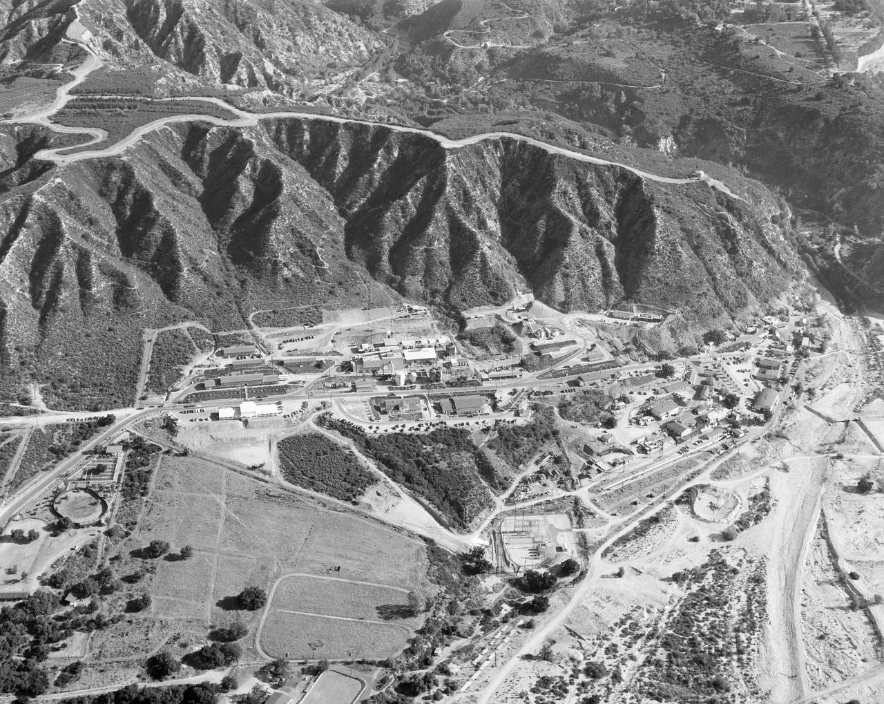
This archival image was released as part of a gallery comparing JPL's past and present, commemorating the 80th anniversary of NASA's Jet Propulsion Laboratory on Oct. 31, 2016. This aerial image of the Jet Propulsion Laboratory was taken in September 1950, when the lab's main patron was the U.S. Army. http://photojournal.jpl.nasa.gov/catalog/PIA21116
This color-enhanced image of the "Castell Henllys" region in Jezero Crater was taken by NASA's Ingenuity Mars Helicopter during the rotorcraft's 48th flight on March 21, 2023, the 741st Martian day, or sol, of the Perseverance rover's mission. At the time the image was taken, the helicopter was at an altitude of about 40 feet (12 meters). This image and others taken during the flight provided advanced reconnaissance to Perseverance scientists and planners roughly two weeks before the rover reached this area. https://photojournal.jpl.nasa.gov/catalog/PIA25890
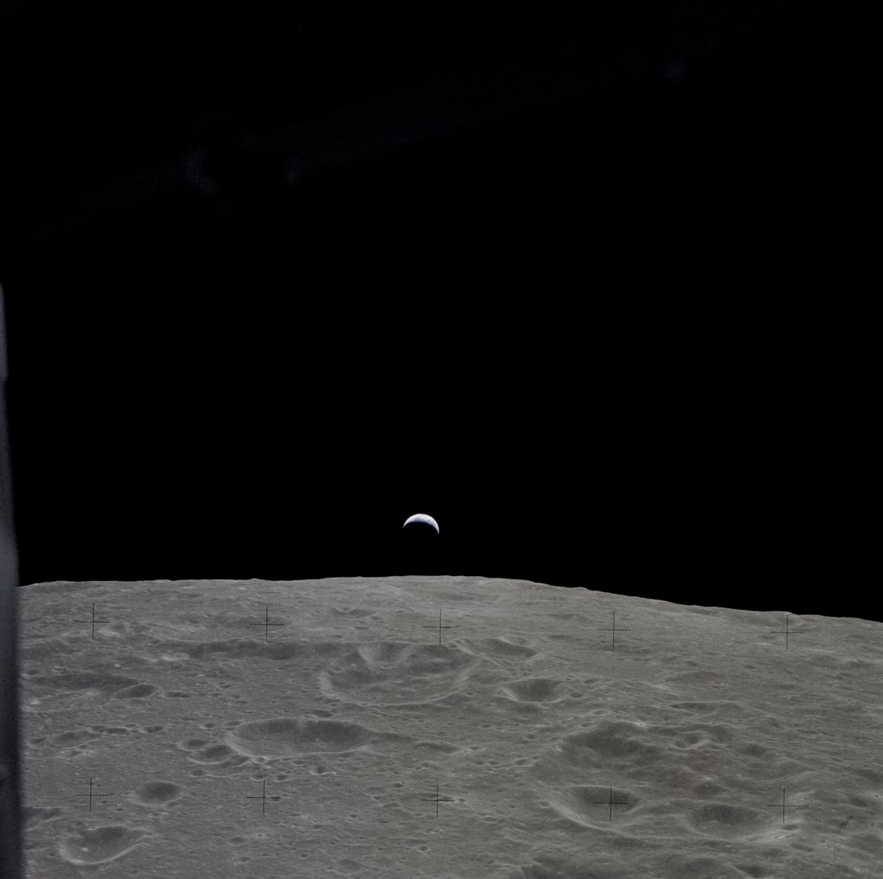
AS12-47-6891 (14-24 Nov. 1969) --- A partially illuminated Earth rises above the lunar horizon in this photograph taken from the Apollo 12 spacecraft in lunar orbit.
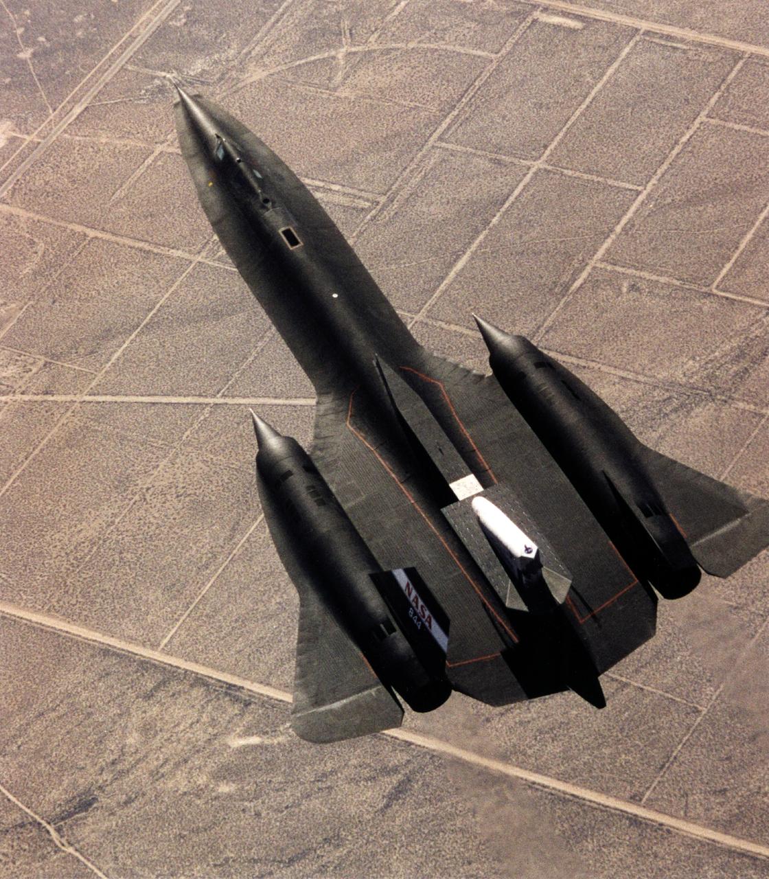
This photograph shows the SR-71 with the Linear Aerospike SR-71 Experiment on the rear fuselage as seen from above. The photo was taken on the first flight of the aircraft with the experiment aboard, which took place on 31 October 1997.

This overhead shot of the X-59 Quiet SuperSonic Technology or QueSST aircraft shows the assembly progress of the vehicle during Spring 2021. The aircraft, under construction at Lockheed Martin Skunk Works in Palmdale, California, will fly to demonstrate the ability to fly supersonic while reducing the loud sonic boom to a quiet sonic thump. Lockheed Martin Photography By Garry Tice 1011 Lockheed Way, Palmdale, Ca. 93599

The European Retrievable Carrier 1L (EURECA-1L) spacecraft, with solar array panels extended, drifts above the Earth after deployment from the payload bay of Atlantis, Orbiter Vehicle (OV) 104, during STS-46. EURECA's onboard propulsion unit will boost it to an operational altitude of 270 nautical miles.

Members of the media observed NASA's Europa Clipper spacecraft from a viewing gallery about High Bay 1 in the historic Spacecraft Assembly Facility at the agency's Jet Propulsion Laboratory on April 11, 2024. The largest spacecraft NASA has ever built for a planetary mission, Europa Clipper is expected to launch in October 2024 on a six-year journey to the Jupiter system, where it will orbit the gas giant and study the ice-encased moon Europa. Europa Clipper's main science goal is to determine whether there are places below the surface of Jupiter's icy moon, Europa, that could support life. The mission's three main science objectives are to determine the thickness of the moon's icy shell and its surface interactions with the ocean below, to investigate its composition, and to characterize its geology. The mission's detailed exploration of Europa will help scientists better understand the astrobiological potential for habitable worlds beyond our planet. https://photojournal.jpl.nasa.gov/catalog/PIA26292

iss071e206529 (June 19, 2024) -- In the North Atlantic Ocean lies Bermuda, an archipelago of more than 180 islands and islets. As the International Space Station orbited 265 miles above, NASA astronaut Matthew Dominick captured this photo.

iss072e518202 (Jan. 23, 2025) --- This long-duration photograph highlights the city lights of Mexico's Yucatan peninsula, Earth's atmospheric glow, and star trails above taken from the International Space Station as it orbited 258 miles above.
AS7-07-1748 (15 Oct. 1968) --- The world's dozen peaks which reach a height of greater than five miles above sea level are seen in this photograph from the Apollo 7 spacecraft at an altitude of approximately 130 nautical miles. The 29,028 ft. high Mount Everest is at lower center. On the central horizon can be seen the 28,250 ft. high Mount Godwin-Austen (K-2) some 800 miles northwest of Mount Everest. In the lower right, Mount Kanchenjunga rises 28,208 ft. to separate Nepal from Sikkim. The snow line on the peaks was at 17,500 ft. In the upper right the lake-studded highlands of Tibet are visible.
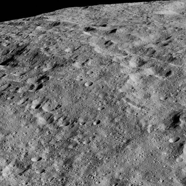
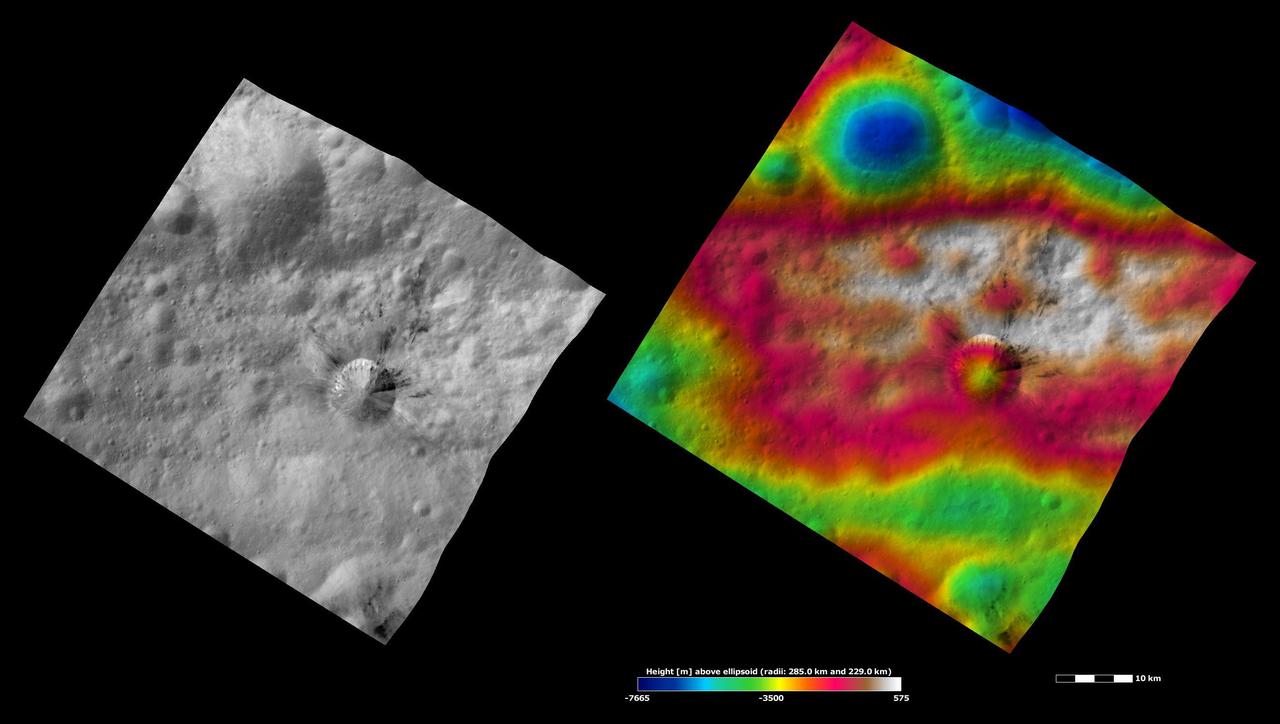
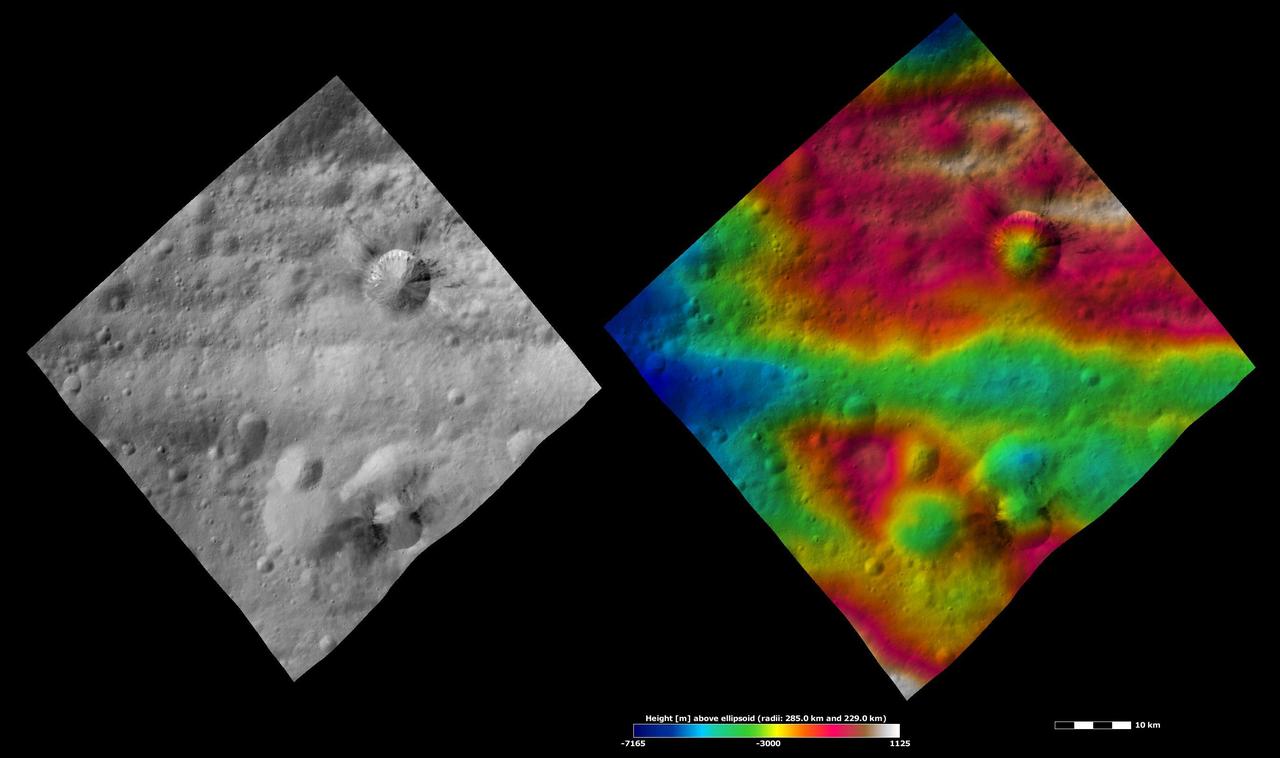
The cone-shaped central peak of a Cerean crater casts a long shadow in this view from NASA Dawn spacecraft taken on May 28, 2016 from its low-altitude mapping orbit above Ceres at a distance of about 240 miles 385 kilometers above the surface. Dawn took this image on May 28, 2016, from its low-altitude mapping orbit above Ceres, at a distance of about 240 miles (385 kilometers) above the surface. The image resolution is 120 feet (35 meters) per pixel. http://photojournal.jpl.nasa.gov/catalog/PIA20879

Saturn rings are dark and elusive in this view from high above the ringplane, but their shadows on the planet give them away

NASA Cassini spacecraft gazes down at the marvelous rings and swirling clouds of giant Saturn from above the planet north pole.

Mangoro River on Madagascar's east coast leads to the Indian Ocean in this photograph from the Indian Ocean as it orbited 263 miles above

Most of Los Angeles is visible in this computer-generated north-northeast perspective viewed from above the Pacific Ocean.
iss071e456772 (July 18, 2024) --- The Moon's glint beams off the Pacific Ocean as stars glitter in the background above the Earth's airglow. The Moon is obscured behind a solar array in this photograph from the International Space Station as it orbited 264 miles above.

iss071e449837 (July 24, 2024) --- The clear blue waters surrounding The Bahamas in the Atlantic Ocean are pictured from the International Space Station as it soared 258 miles above.
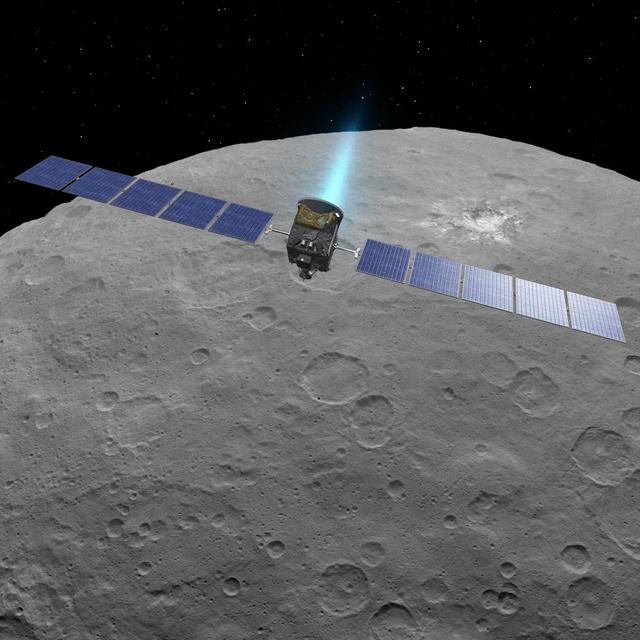
This artist concept shows NASA Dawn spacecraft above dwarf planet Ceres, as seen in images from the mission. http://photojournal.jpl.nasa.gov/catalog/PIA19598

iss071e462185 (Aug. 9, 2024) --- Lake Balkhash in Kazakhstan is pictured from the International Space Station as it orbited 262 miles above the Central Asian nation.

iss069e003869 (April 16, 2023) --- Lake Powell, separating Utah from Arizona, is pictured from an external high definition camera on the International Space Station as it orbited 260 miles above.

iss058e002245 (Jan. 7, 2019) --- The U.S. Cygnus space freighter from Northrop Grumman and its prominent cymbal-shaped UltraFlex solar arrays are pictured as the International Space Station orbited 262 miles above the Atlantic Ocean off the coast of Argentina. Towards the top center of the photograph is the seven-windowed cupola with its shutters open.
This image of NASA's Perseverance Mars rover – visible at the top, right of center – was taken by the Ingenuity Mars Helicopter during its 54th flight on Aug. 3, 2023, 872nd Martian day, or sol, of the mission. At the time the image was taken, the helicopter was at an altitude of about 16 feet (5 meters). https://photojournal.jpl.nasa.gov/catalog/PIA25969

This graphic of Jupiter moon Europa maps a relationship between the amount of energy deposited onto the moon from charged-particle bombardment and chemical contents of ice deposits.
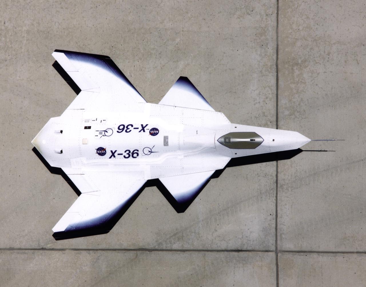
This look-down view of the X-36 Tailless Fighter Agility Research Aircraft on the ramp at NASA’s Dryden Flight Research Center, Edwards, California, clearly shows the unusual wing and canard design of the remotely-piloted aircraft.

The Lockheed Martin/Boeing Tier III- (minus) unpiloted aerial vehicle is inspected by NASA personnel September 14, 1995, following its arrival at the Dryden Flight Research Center, Edwards, California.
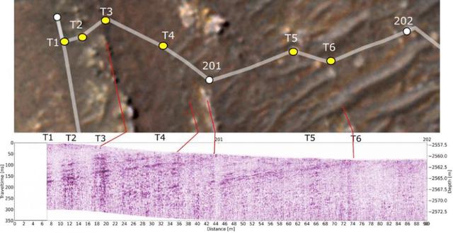
This annotated-composite graphic shows the entry of NASA's Perseverance rover into the "South Séítah" geologic unit from both an orbital and subsurface perspective. The annotated view from NASA's Mars Reconnaissance Orbitor (MRO) depicts the route Perseverance took into Séítah. The image was provided by MRO's High Resolution Imaging Experiment (HiRISE). The graphic below the orbital image is the first "radargram" to be released by the Radar Imager for Mars' Subsurface Experiment (RIMFAX) instrument aboard Perseverance. It shows the subsurface as the rover drove across the "Artuby" ridgeline. The red lines link bright subsurface "reflectors" to erosion-resistant layers outcropping at the surface. The University of Arizona, in Tucson, operates HiRISE, which was built by Ball Aerospace & Technologies Corp., in Boulder, Colorado. NASA's Jet Propulsion Laboratory, a division of Caltech in Pasadena, California, manages the Mars Reconnaissance Orbiter Project for NASA's Science Mission Directorate, Washington. A key objective for Perseverance's mission on Mars is astrobiology, including the search for signs of ancient microbial life. The rover will characterize the planet's geology and past climate, pave the way for human exploration of the Red Planet, and be the first mission to collect and cache Martian rock and regolith (broken rock and dust). Subsequent NASA missions, in cooperation with ESA (European Space Agency), would send spacecraft to Mars to collect these sealed samples from the surface and return them to Earth for in-depth analysis. https://photojournal.jpl.nasa.gov/catalog/PIA25025
This image from NASA Dawn spacecraft is of the south pole region of the asteroid Vesta, a mountain is rising approximately 9 miles 15 kilometers above the floor of a crater.
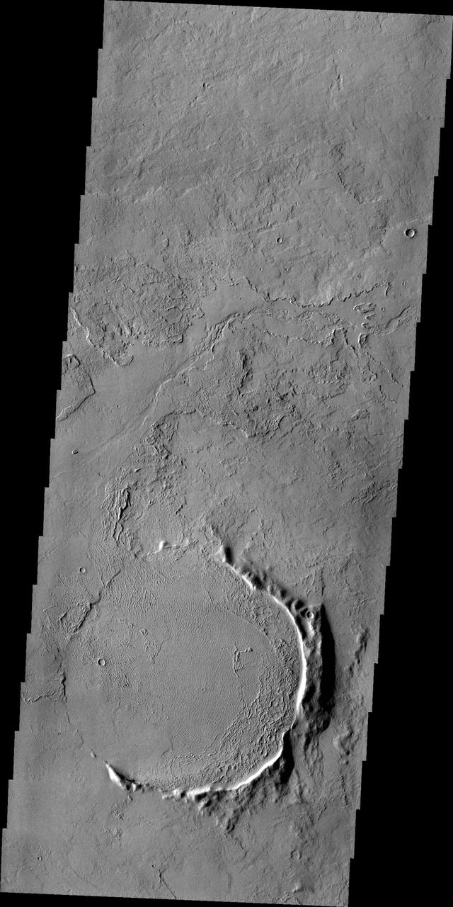
Only part of the rim of an unnamed crater remains visible above the lava flows in this region of Tharsis. This image is from NASA 2001 Mars Odyssey spacecraft.

An orbital sunrise illuminates the cloud tops in this photograph from the International Space Station as it soared 262 miles above Namibia near the Atlantic coast.

Pan is nearly lost within Saturn rings in this view captured by NASA Cassini spacecraft of a small section of the rings from just above the ringplane.
From high above Titan northern hemisphere, the Cassini spacecraft takes an oblique view toward the mid-latitude dark regions that gird the giant moon

Abu Dhabi, the capital of the United Arab Emirates on the Persian Gulf coast, is pictured from the International Space Station as it soared 257 miles above the Middle East.
An aurora, shining high above the northern part of Saturn, moves from the night side to the day side of the planet in this movie recorded by NASA Cassini spacecraft.
The high northern latitudes on Enceladus show little detail from Cassini distant vantage point, nearly 50 degrees above the moon equator
This image shows the limb of Ceres from above an equatorial region east of Kirnis Crater. The scene is centered at approximately 10 degrees north latitude, 284 degrees east longitude. NASA's Dawn spacecraft took this image on June 13, 2016, from its low-altitude mapping orbit, at a distance of about 240 miles (385 kilometers) above the surface. The image resolution is 120 feet (35 meters) per pixel. http://photojournal.jpl.nasa.gov/catalog/PIA20825
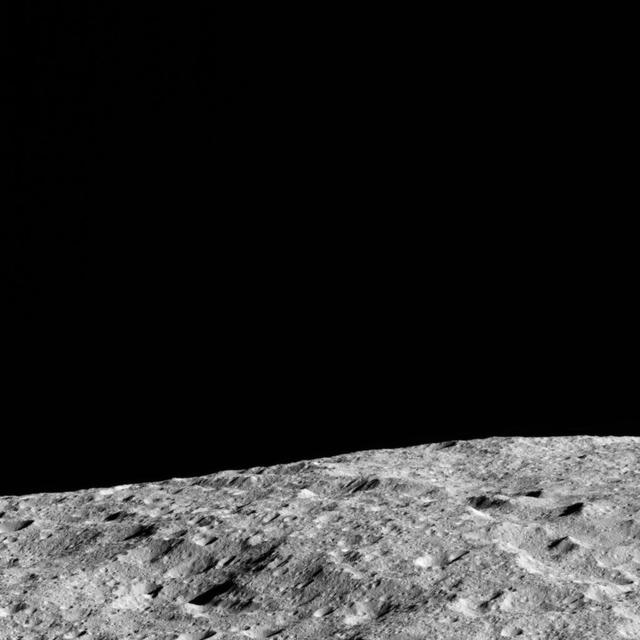
This image shows the limb of Ceres from above an equatorial region east of Kirnis Crater. The scene is centered at approximately 12 degrees north latitude, 280 degrees east longitude. NASA's Dawn spacecraft took this image on June 13, 2016, from its low-altitude mapping orbit, at a distance of about 240 miles (385 kilometers) above the surface. The image resolution is 120 feet (35 meters) per pixel. http://photojournal.jpl.nasa.gov/catalog/PIA20824
Saturn shares its space with its moon Tethys in this scene captured by NASA Cassini spacecraft. Tethys can be seen above the rings near the middle of the image. This view looks toward the northern, sunlit side of the rings from just above the ringplane.

iss069e004821 (April 21, 2023) --- The Cygnus space freighter from Northrop Grumman is poised for release from the Canadarm2 robotic arm as the International Space Station orbited 262 miles above the north Atlantic Ocean.

iss069e004825 (April 21, 2023) --- The Cygnus space freighter from Northrop Grumman is poised for release from the Canadarm2 robotic arm as the International Space Station orbited 263 miles above the Atlantic Ocean off the coast of Ireland.
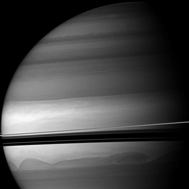
Huge clouds swirl through the southern latitudes of Saturn where the rings cast dramatic shadows. This view from NASA Cassini spacecraft looks toward the northern, sunlit side of the rings from just above the ringplane.
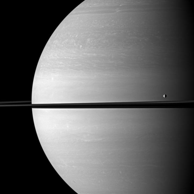
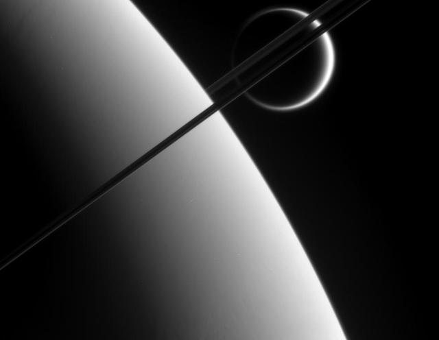
The moon Tethys occupies the right foreground of this Saturnian scene. This view from NASA Cassini spacecraft looks toward the anti-Saturn side of Tethys and toward the northern, sunlit side of the rings from just above the ringplane.
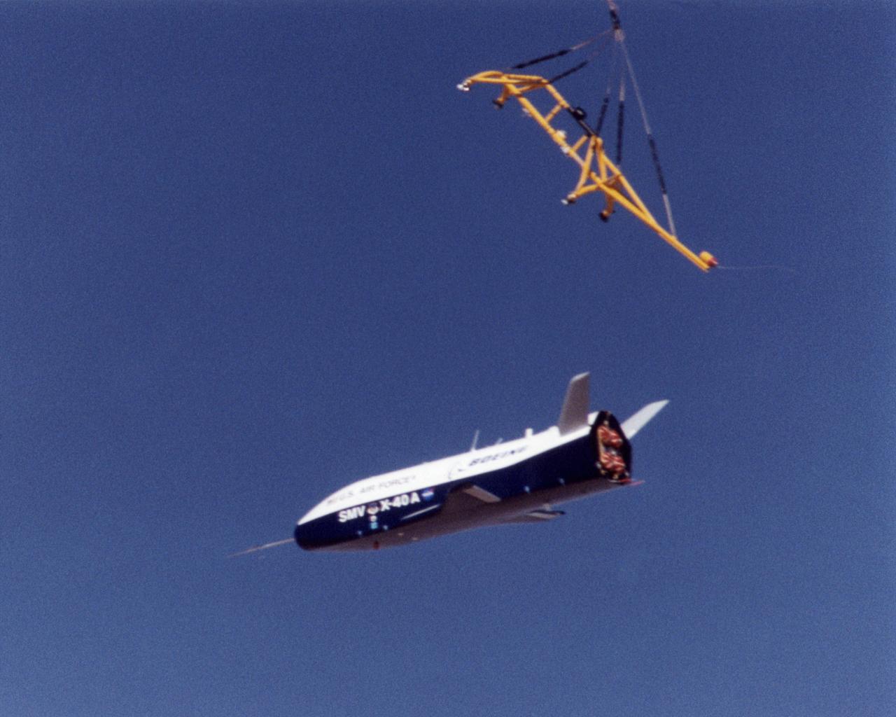
The X-40A immediately after release from its harness suspended from a helicopter 15,000 feet above NASA's Dryden Flight Research Center at Edwards Air Force Base, California, on March 14, 2001. The unpiloted X-40 is a risk-reduction vehicle for the X-37, which is intended to be a reusable space vehicle. NASA's Marshall Space Flight Center in Huntsville, Ala, manages the X-37 project. At Dryden, the X-40A will undergo a series of ground and air tests to reduce possible risks to the larger X-37, including drop tests from a helicopter to check guidance and navigation systems planned for use in the X-37. The X-37 is designed to demonstrate technologies in the orbital and reentry environments for next-generation reusable launch vehicles that will increase both safety and reliability, while reducing launch costs from $10,000 per pound to $1,000 per pound.
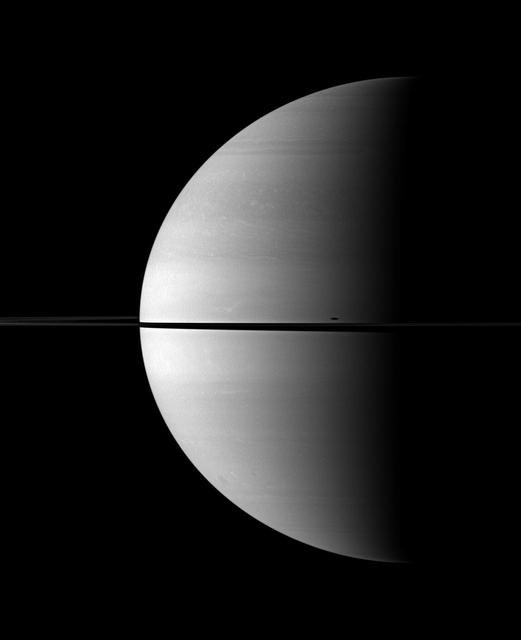
An illusion of perspective, Saturn's moon Tethys seems to hang above the planet's north pole in this view from NASA's Cassini spacecraft. Tethys (660 miles or 1,062 kilometers across) is actually farther away than Saturn in this image. Lacking visual clues about distance, our brains place the moon above Saturn's north pole. Tethys, like all of Saturn's major moons and its ring system, orbits almost exactly in the planet's equatorial plane. This view looks toward the sunlit side of the rings from about 17 degrees above the ring plane. The image was taken with the Cassini spacecraft's wide-angle camera on Jan. 26, 2015 using a spectral filter which preferentially admits wavelengths of near-infrared light centered at 752 nanometers. The view was acquired at a distance of approximately 2.1 million miles (3.4 million kilometers) from Saturn. Image scale on Saturn is 120 miles (200 kilometers) per pixel. Tethys has been brightened by a factor of three relative to Saturn to enhance its visibility. http://photojournal.jpl.nasa.gov/catalog/PIA20488
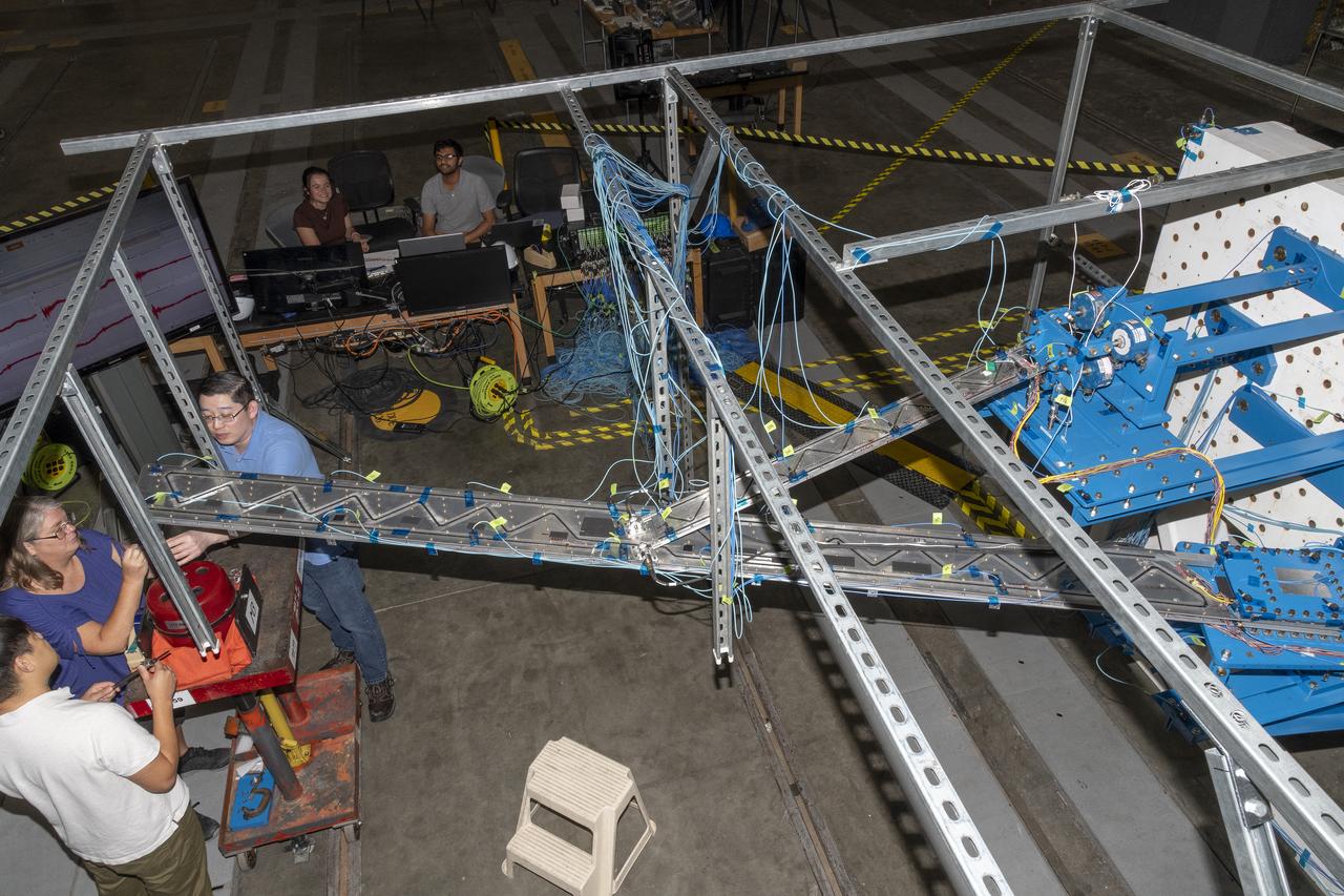
Researchers test a 10-foot Mock Truss-Braced Wing at NASA’s Armstrong Flight Research Center in Edwards, California. A view from above shows the test structure, the wing, and the strut. The aircraft concept involves a wing braced on an aircraft using diagonal struts that also add lift and could result in significantly improved aerodynamics.
iss071e462182 (Aug. 9, 2024) --- Barsakelmes Nature Reserve in the Aral Sea in Kazakhstan is pictured from the International Space Station as it orbited 263 miles above the Central Asian nation.

iss071e439719 (Aug. 6, 2024) --- A wildfire in Canada and its smoke spreading in the atmosphere are pictured from the Intenational Space Station as it orbited 263 miles above North Dakota.

iss071e462173 (Aug. 8, 2024) --- Wildfires in northern California are pictured from the International Space Station as it orbited 261 miles above the Pacific Ocean off the coast of Washington's Olympic National Forest.

iss071e345427 (July 15, 2024) --- The Mayotte archipelago, a French overseas department and region, in the Mozambique Channel and in between Madagascar and Mozambique is pictured from the International Space Station as it orbited 263 miles above.

NASA’s X-59 Quiet SuperSonic Technology airplane undergoes structural stress tests at a Lockheed Martin facility in Fort Worth, Texas. Lockheed Martin Aeronautics Company - Fort Worth - Chris Hanoch Subject: X-59 - Various Angles in Test Fixture FP#: 21-03420 POC: Analiese Smith, Chris Higgins Other info: X-59 in Fort Worth, testing; high angle shots in fixture 1-10-22

This composite view from NASA Voyager 2 shows Neptune on Triton horizon. The foreground in this computer generated view of Triton maria as they would appear from a point approximately 45 km above the surface. http://photojournal.jpl.nasa.gov/catalog/PIA00344

iss069e004822 (April 21, 2023) --- The Cygnus space freighter from Northrop Grumman is pictured moments after its release from the Canadarm2 robotic arm as the International Space Station orbited 262 miles above the Mediterranean Sea near the Spanish island of Mallorca.
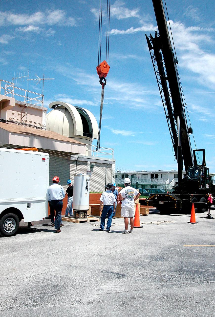
KENNEDY SPACE CENTER, FLA. - In Cocoa Beach, Fla., a new five-meter telescope sits on a pallet waiting to be lifted up to the dome above and installed. The tracking telescope is part of the Distant Object Attitude Measurement System (DOAMS) that provides optical support for launches from KSC and Cape Canaveral.

This mosaic from NASA Galileo Probe is of an equatorial hotspot on Jupiter and shows the features of a hazy cloud layer tens of kilometers above Jupiter main visible cloud deck.

This mosaic from NASA Galileo Probe is of an equatorial hotspot on Jupiter and shows the features of a hazy cloud layer tens of kilometers above Jupiter main visible cloud deck. http://photojournal.jpl.nasa.gov/catalog/PIA02200
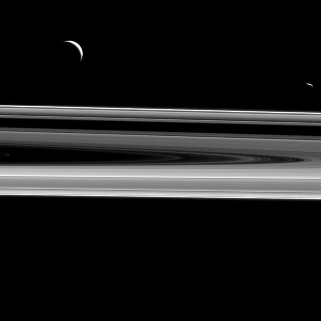
Two moons hover above the rings from this perspective, Enceladus 313 miles or 504 kilometers across, at left, and Janus 111 miles or 179 kilometers across, at right as seen by NASA Cassini spacecraft.

iss069e005471 (April 26, 2023) --- The Richat Structure, also known as the "Eye of the Sahara," an eroded geological dome in the nation of Mauritania, is pictured from the International Space Station as it orbited 259 miles above the African continent.
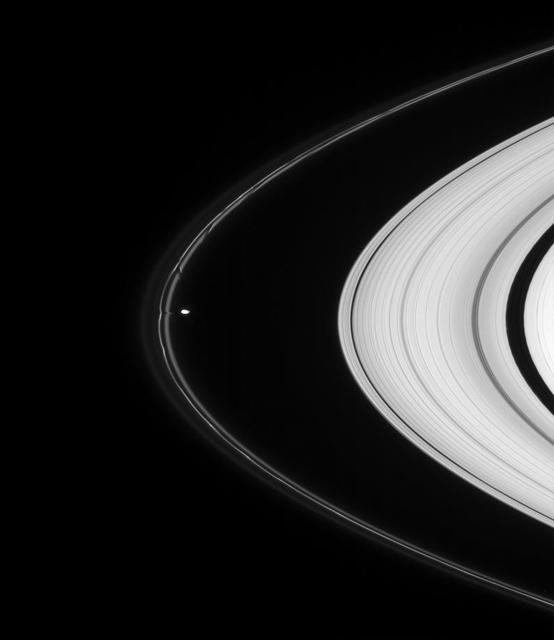
Prometheus pulls material from the tortured F ring in this highly detailed view. The aftereffects of the moon other recent encounters with the ring are visible above as dark channels in the inner ringlet
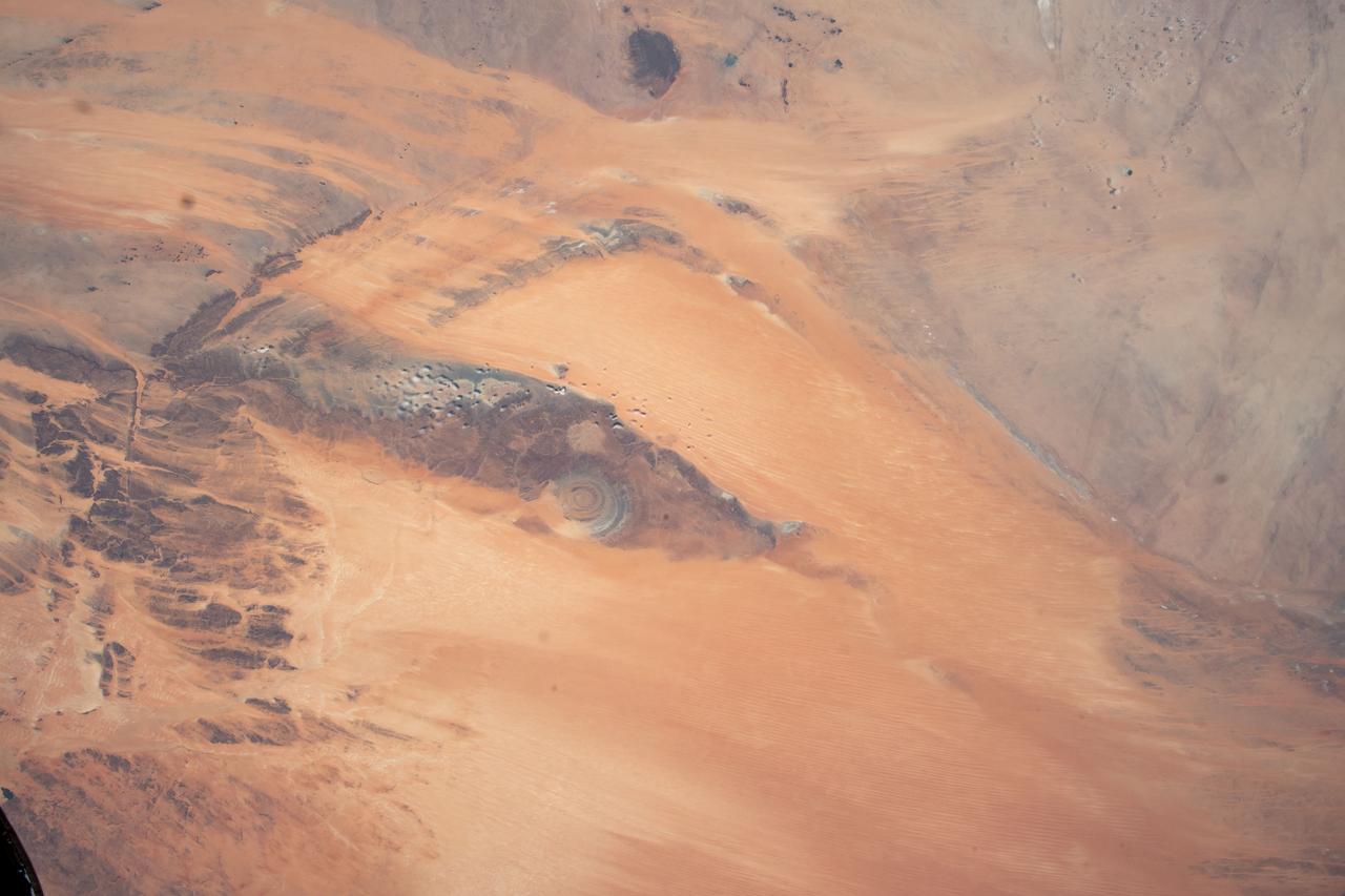
iss069e005526 (April 26, 2023) --- The Richat Structure, also known as the "Eye of the Sahara," an eroded geological dome in the nation of Mauritania, is pictured from the International Space Station as it orbited 259 miles above the African continent.

Mount San Antonio more commonly known as Mount Baldy crowns the San Gabriel Mountains northeast of Los Angeles in this computer-generated east-northeast perspective viewed from above the Malibu coastline.
Islands of older high-standing terrain rise above a sea of relatively young, platy lava flows between two of the largest volcanoes in the solar system in this image from NASA Mars Odyssey spacecraft.
This view was taken from above the ringplane and looks toward the unlit side of the rings. Here, the probe gazes upon Titan in the distance beyond Saturn and its dark and graceful rings
This is the first global map of the giant asteroid Vesta composed from images recorded by the framing camera aboard NASA Dawn spacecraft. The equator is running parallel to the upper image border, approximately above the bright, smooth band of troughs.
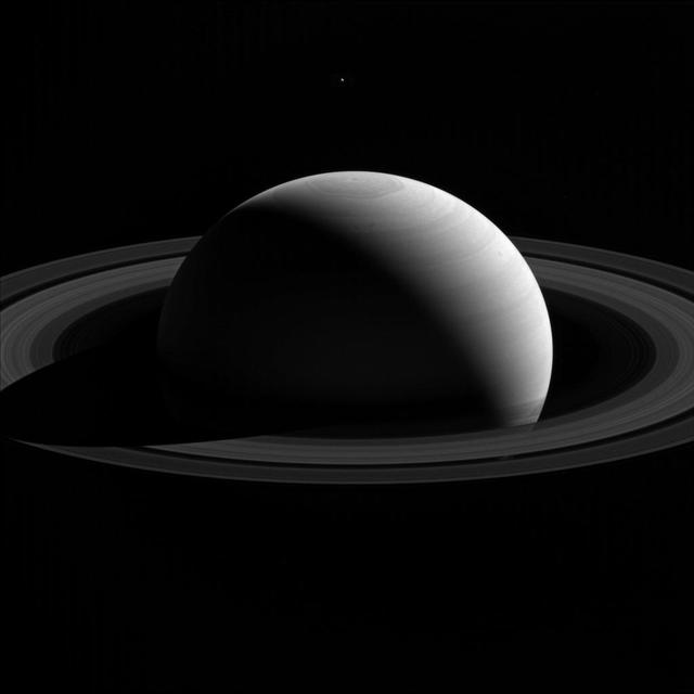
Janus is spotted over Saturn north pole in this image while Mimas shadow glides across Saturn in this image from NASA Cassini spacecraft. Janus is the faint dot that appears just above Saturn north pole.
Dione shadow is elongated as it is cast onto the round shape of Saturn in this image taken by NASA Cassini spacecraft. The moon is not visible here. This view looks toward the northern, sunlit side of the rings from just above the ringplane.
These images from NASA Dawn spacecraft are located in asteroid Vesta Gegania quadrangle, just south of Vesta equator. Rubria is the crater with dark and bright material above Divalia Fossa and Occia is the crater with bright and dark material below.
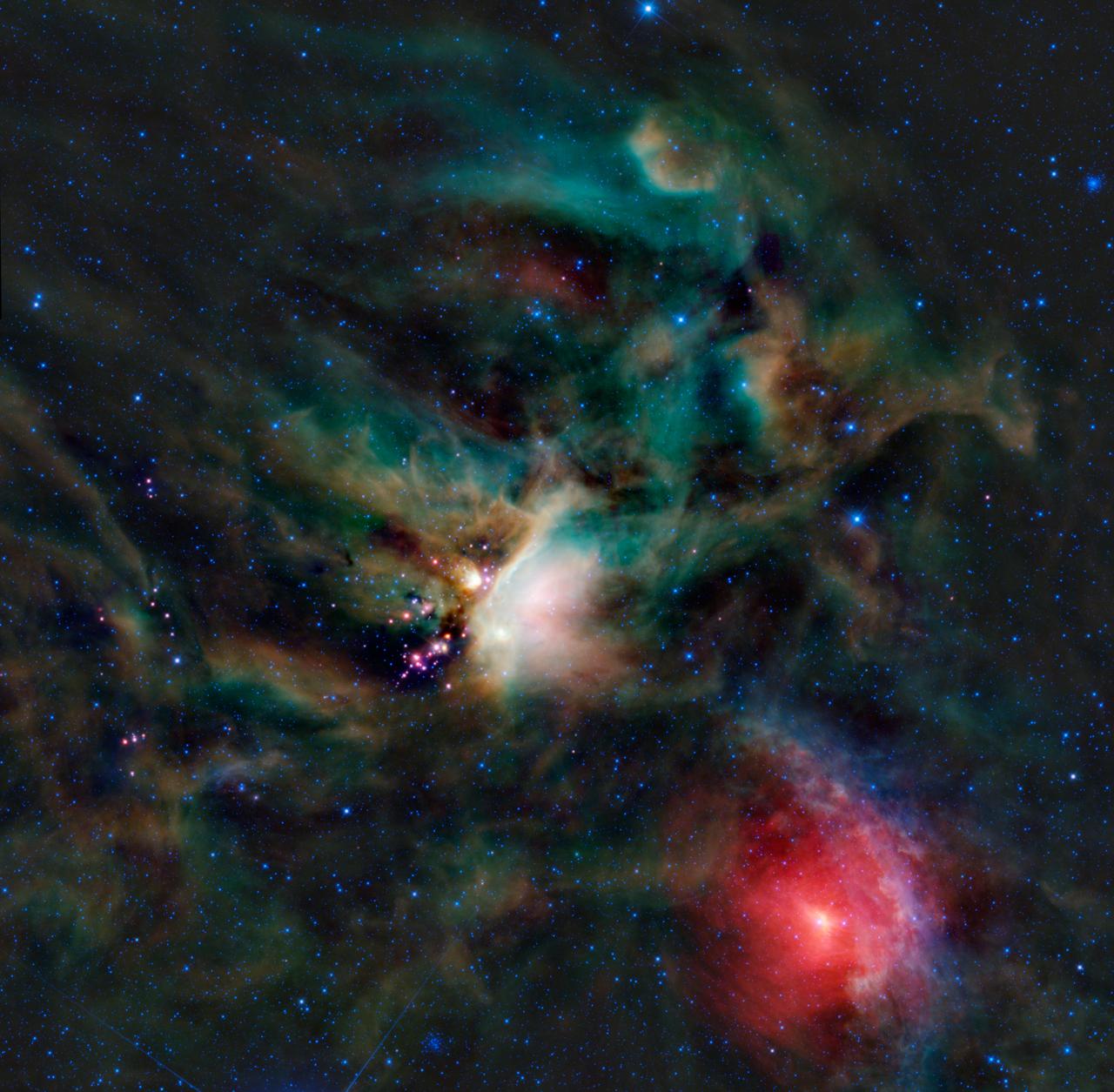
A rich collection of colorful astronomical objects is revealed in this picturesque image of the Rho Ophiuchi cloud complex from NASA Wide-field Infrared Explorer; the cloud is found rising above the plane of the Milky Way in the night sky.

This mosaic from NASA Galileo Probe is of an equatorial hotspot on Jupiter and shows the features of a hazy cloud layer tens of kilometers above Jupiter main visible cloud deck.
The shadow of Saturn moon Mimas is elongated across the planet in this image from NASA Cassini spacecraft. The moon itself is not shown, but the shadow appears just above the ringplane on the right of the image.

This image of the Earth is one of 60 frames taken by NASA Voyager 1 spacecraft on Feb. 14, 1990 from a distance of approximately 4 billion miles and about 32 degrees above the ecliptic plane.
These images from NASA Dawn spacecraft are located in asteroid Vesta Gegania quadrangle, just south of Vesta equator. Rubria, with dark and bright material is above Divalia Fossa, and Occia, with bright and dark material is below.
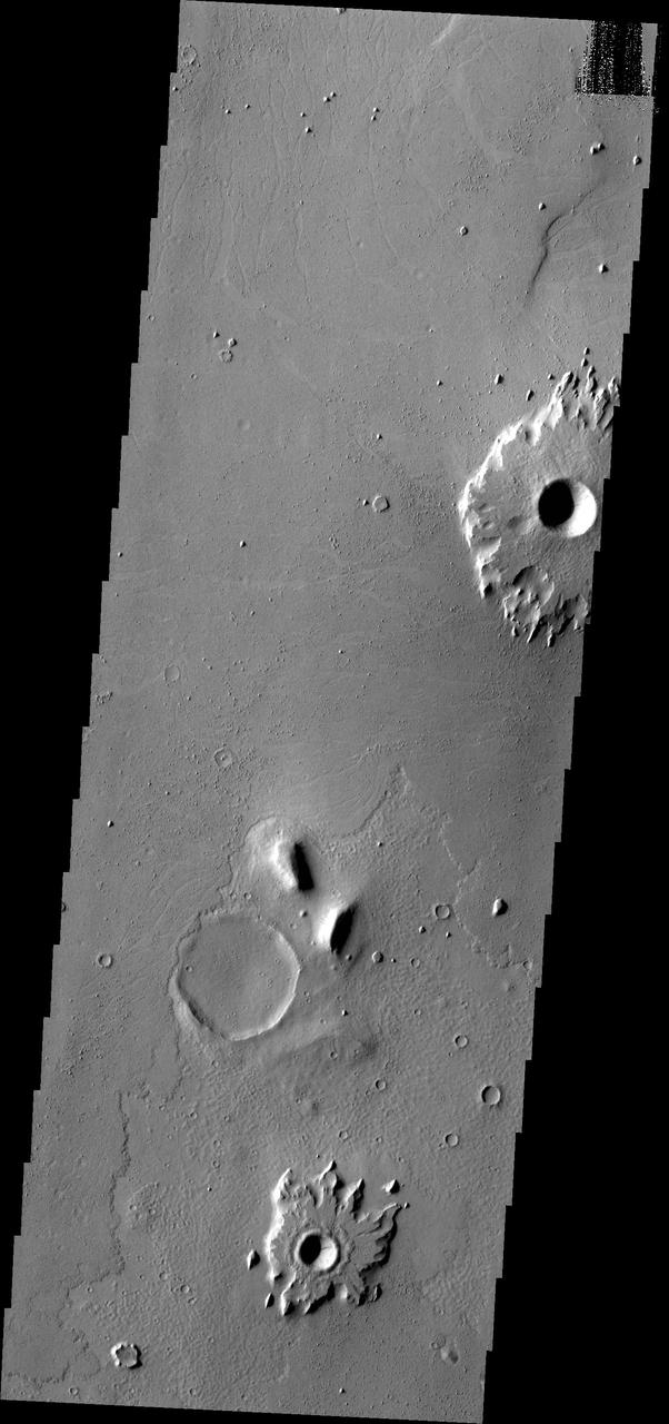
The southern Amazonis Planitia shows two craters with ejecta that stand out above the surrounding surface. The ejecta has remained in place while the surrounding material was removed. This image is from NASA 2001 Mars Odyssey spacecraft.

iss069e004909 (April 21, 2023) --- The Cygnus space freighter from Northrop Grumman is pictured in the grips of the Canadarm2 robotic arm as the International Space Station orbited 258 miles above the Arabian Sea coast of India.