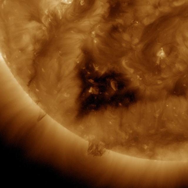
This Solar Dynamics Observatory (SDO) image of the Sun taken on January 20, 2012 in extreme ultraviolet light captures a heart-shaped dark coronal hole. Coronal holes are areas of the Sun's surface that are the source of open magnetic field lines that head way out into space. They are also the source regions of the fast solar wind, which is characterized by a relatively steady speed of approximately 800 km/s (about 1.8 million mph). <b><a href="http://www.nasa.gov/audience/formedia/features/MP_Photo_Guidelines.html" rel="nofollow">NASA image use policy.</a></b> <b><a href="http://www.nasa.gov/centers/goddard/home/index.html" rel="nofollow">NASA Goddard Space Flight Center</a></b> enables NASA’s mission through four scientific endeavors: Earth Science, Heliophysics, Solar System Exploration, and Astrophysics. Goddard plays a leading role in NASA’s accomplishments by contributing compelling scientific knowledge to advance the Agency’s mission. <b>Follow us on <a href="http://twitter.com/NASA_GoddardPix" rel="nofollow">Twitter</a></b> <b>Like us on <a href="http://www.facebook.com/pages/Greenbelt-MD/NASA-Goddard/395013845897?ref=tsd" rel="nofollow">Facebook</a></b> <b>Find us on <a href="http://instagram.com/nasagoddard?vm=grid" rel="nofollow">Instagram</a></b>
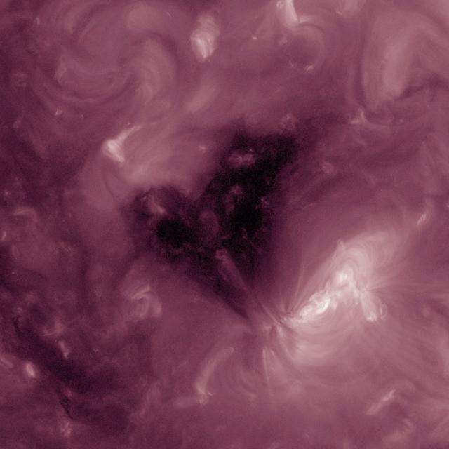
This Solar Dynamics Observatory image of the Sun taken on February 1, 2013 in extreme ultraviolet light captures a heart-shaped dark coronal hole. Coronal holes are areas of the Sun's surface that are the source of open magnetic field lines that head way out into space. They are also the source regions of the fast solar wind, which is characterized by a relatively steady speed of approximately 800 km/s (about 1.8 million mph).

This Solar Dynamics Observatory (SDO) image of the Sun taken on January 20, 2012 in extreme ultraviolet light captures a heart-shaped dark coronal hole. Coronal holes are areas of the Sun's surface that are the source of open magnetic field lines that head way out into space. They are also the source regions of the fast solar wind, which is characterized by a relatively steady speed of approximately 800 km/s (about 1.8 million mph). <b><a href="http://www.nasa.gov/audience/formedia/features/MP_Photo_Guidelines.html" rel="nofollow">NASA image use policy.</a></b> <b><a href="http://www.nasa.gov/centers/goddard/home/index.html" rel="nofollow">NASA Goddard Space Flight Center</a></b> enables NASA’s mission through four scientific endeavors: Earth Science, Heliophysics, Solar System Exploration, and Astrophysics. Goddard plays a leading role in NASA’s accomplishments by contributing compelling scientific knowledge to advance the Agency’s mission. <b>Follow us on <a href="http://twitter.com/NASA_GoddardPix" rel="nofollow">Twitter</a></b> <b>Like us on <a href="http://www.facebook.com/pages/Greenbelt-MD/NASA-Goddard/395013845897?ref=tsd" rel="nofollow">Facebook</a></b> <b>Find us on <a href="http://instagram.com/nasagoddard?vm=grid" rel="nofollow">Instagram</a></b>
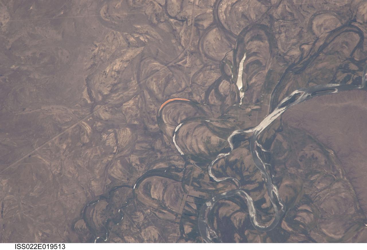
ISS022-E-019513 (4 Jan. 2010) --- The Rio Negro floodplain in Patagonia, Argentina is featured in this image photographed by an Expedition 22 crew member on the International Space Station. The Rio Negro is recognizable by astronaut crews from orbit as one of the most meandering rivers in South America. This is well illustrated in this view, where the entire river floodplain (approximately 10 kilometers wide) is covered with curved relics of channels known as meander scars. The main channel of the river, flowing south at this point?60 kilometers south of the city of Choele Choel (not shown)?appears in partial sun glint at right. Sun glint occurs when light is reflected off a water surface directly back towards the viewer, imparting a silvery sheen to those areas. When meander scars contain water they are known as oxbow lakes, some of which are also highlighted by sun glint in the image. Meander scars show the numerous past positions of river bends, produced as the river snaked across the plain in the very recent geological past. The Rio Negro is a dramatic example of how mobile a river can be. The orange tint to the water in one of the oxbow lakes (center) could result from orange salt-loving algae. Their appearance here would be unusual since floodplain lakes are usually too fresh for algae blooms. But an explanation may lie in the location of the Rio Negro on the margin of Argentina?s arid Patagonian region with annual rainfall less than 12 inches (300 mm). Evaporation in this cloudless region could be high enough for some lakes to become salty. The Rio Negro flows generally southeast from the Andes Mts. to the Atlantic Ocean. Its floodplain supports the biggest pear- and apple-growing region of Argentina. Rectangular farm boundaries can be seen at bottom center. The river also hosts the world?s longest kayak regatta (653 kilometers), which lasts six days.
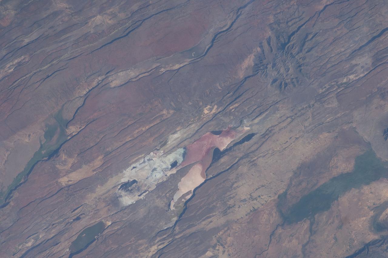
ISS030-E-035487 (14 Jan. 2012) --- The East African Rift Valley in Kenya is featured in this image photographed by an Expedition 30 crew member on the International Space Station. This photograph highlights classical geological structures associated with a tectonic rift valley, in this case the Eastern Branch of the East African Rift near Kenya’s southern border with Tanzania and just south of the Equator. The East African Rift is one of the great tectonic features of Africa, caused by fracturing of Earth’s crust. The Nubian (or African) plate includes the older continental crust of Africa to the west, while the Somalian plate that is moving away includes the Horn of Africa to the northeast; the tectonic boundary stretches from the southern Red Sea to central Mozambique. Landscapes in the rift valley can appear confusing. The most striking features in this view are the numerous, nearly parallel, linear fault lines that occupy the floor of the valley (most of the image). Shadows cast by the late afternoon sun make the fault scarps (steps in the landscape caused by slip motion along individual faults) more prominent. The faults are aligned with the north-south axis of the valley (lower left to top right). A secondary trend of less linear faults cuts the main fault trend at an acute angle, the fault steps throwing large shadows. The Eastern Branch of the East African Rift is arid (compared with the Western Branch which lies on the border of the Congolese rainforest). Evidence of this can be seen in the red, salt-loving algae of the shallow and salty Lake Magadi (center). A neighboring small lake to the north has deeper water and appears dark in the image. The white salt deposits of the dry part of the Lake Magadi floor (center) host a few small commercial salt pans. The lakes appear to be located where the main and secondary fault trends intersect. The East African rift system is marked by substantial volcanic activity, including lavas erupted from fissures along the rift in the region. Much of the faulting observed in this image cuts through such lavas. Elsewhere along the rift system individual volcanoes form. Some of those volcanoes are very large, including Mt. Kilimanjaro and Mt. Kenya. In this image, rising 400 meters above the valley floor, a volcano appears to be superimposed on the faults—indicating that the volcano is younger than the faults it covers. Deeply eroded slopes also suggest that the volcano has not been active for a long time. The largest vegetated area (lower left)—in an desert zone with no vegetation visible to the naked eye from space—is the green floor of a valley which drains an area large enough for water to exist near the surface so that plants can thrive. For a sense of scale, the vegetated valley floor is 17 kilometers long (10.5 miles).