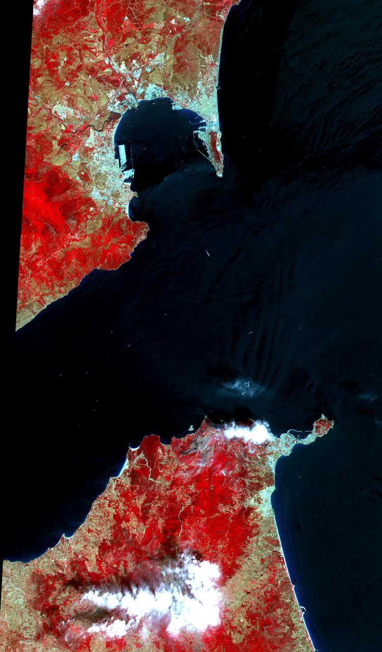
This 34 by 59 km sub-scene, acquired on July 5, 2000, covers the eastern part of the Strait of Gibraltar, separating Spain from Morocco. The promontory on the eastern side of the conspicuous Spanish port is the Rock of Gibraltar. The Rock of Gibraltar was once one of the two classical Pillars of Hercules, crowned with silver columns by Phoenician mariners to mark the limits of safe navigation for the ancient Mediterranean peoples. The rocky promontory still commands the western entrance to the Mediterranean Sea, separated from North Africa only by the narrow Strait of Gibraltar. A British colony, Gibraltar occupies a narrow strip of land at the southernmost tip of the Iberian Peninsula. It is separated from the Spanish mainland by a neutral zone contained on a narrow, sandy isthmus. The rocky limestone and shale ridge known as the Rock rises abruptly from the sea, to a maximum elevation of 426 meters (1,398 feet). Because of its strategic location and formidable topography, Gibraltar serves mainly as a British fortress. The Rock has traditionally been a symbol of British naval strength. Most of its sparse land is taken up by air and naval installations, and the civilian population is small. The image is centered at 36 degrees north latitude, 5.5 degrees west longitude. http://photojournal.jpl.nasa.gov/catalog/PIA11167

The Strait of Gibraltar separates Spain from Morocco. This image, acquired on July 5, 2000, covers an area 34 kilometers (21 miles) wide and 59 kilometers (37 miles) long in three bands of the reflected visible and infrared wavelength region. The promontory on the eastern side of the conspicuous Spanish port is the Rock of Gibraltar. Once one of the two classical Pillars of Hercules, the Rock was crowned with silver columns by Phoenician mariners to mark the limits of safe navigation for the ancient Mediterranean peoples. The rocky promontory still commands the western entrance to the Mediterranean Sea. The rocky limestone and shale ridge rises abruptly from the sea, to a maximum elevation of 426 meters (1,398 feet). A British colony, Gibraltar occupies a narrow strip of land at the southernmost tip of the Iberian Peninsula. It is separated from the Spanish mainland by a neutral zone contained on a narrow, sandy isthmus. Because of its strategic location and formidable topography, Gibraltar serves mainly as a British fortress. Most of its sparse land is taken up by air and naval installations, and the civilian population is small. http://photojournal.jpl.nasa.gov/catalog/PIA02657

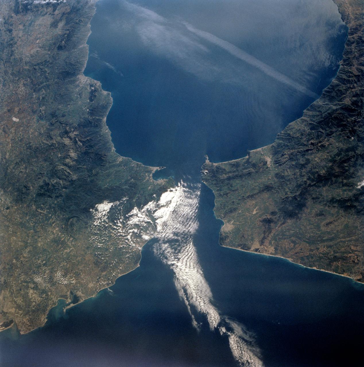
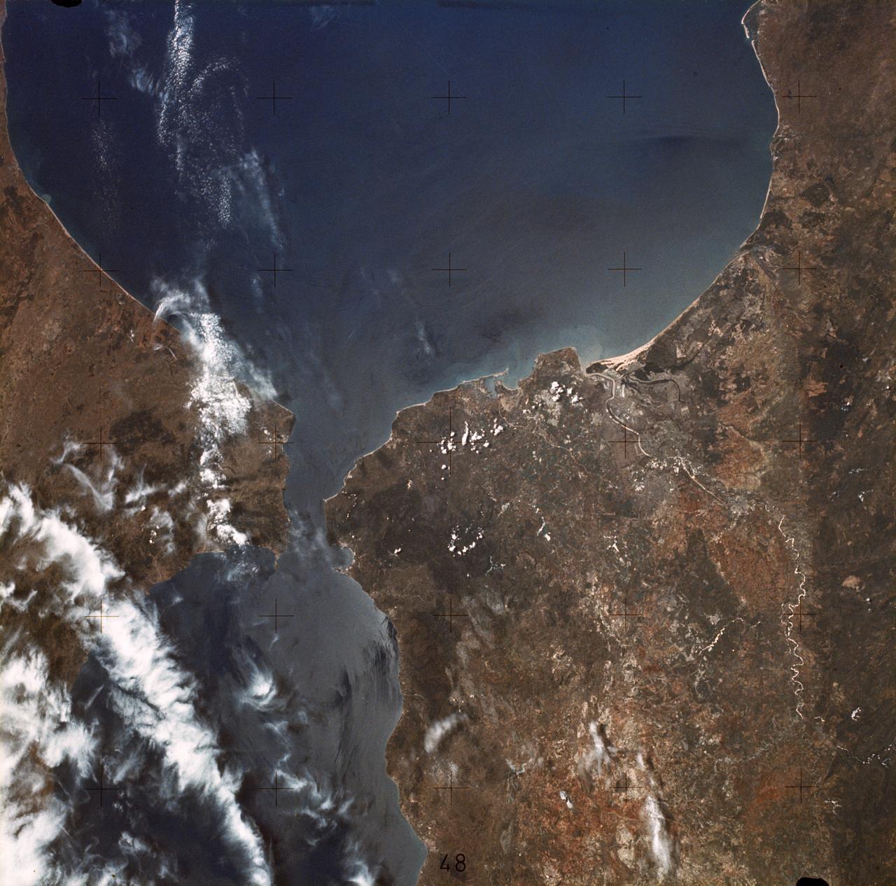
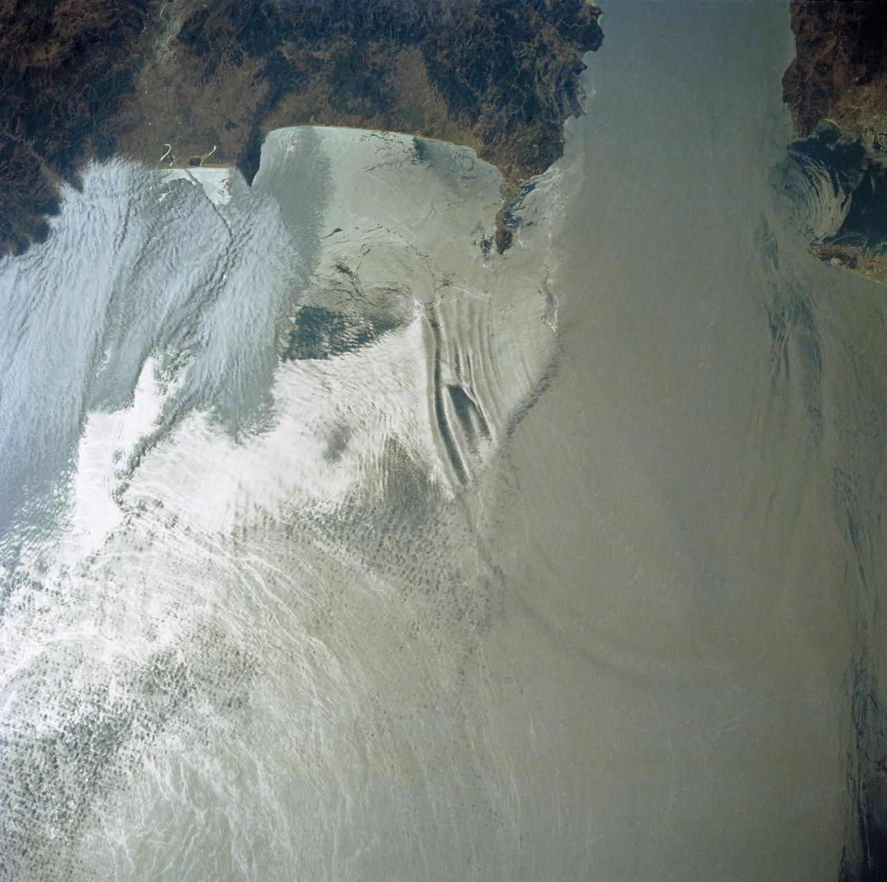
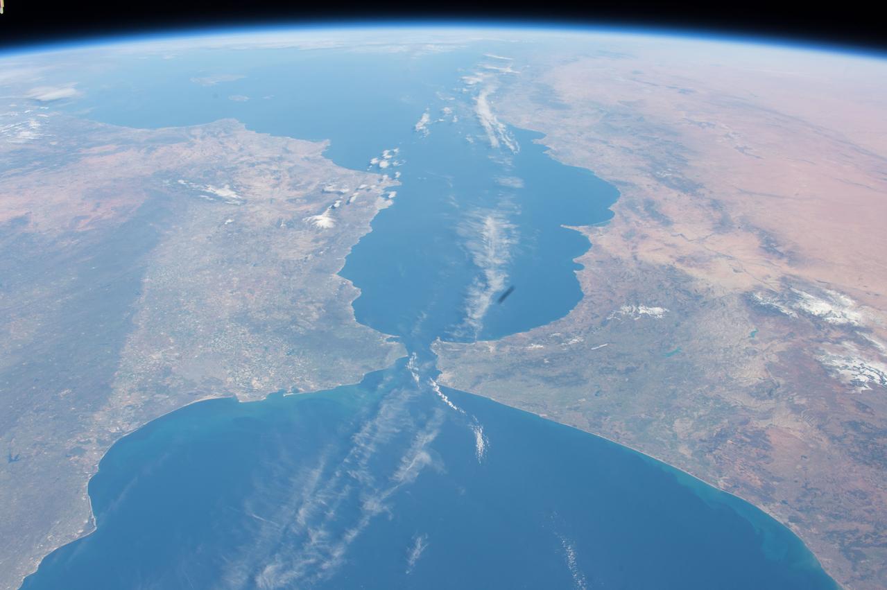
STS060-88-070 (3-11 Feb 1994) --- This view shows sunglint in the Strait of Gibralter. In this photograph a high pressure atmospheric system over the Iberian Peninsula has set the conditions for seeing a plankton bloom along the Moroccan coast in the Alboran Sea (Western Mediterranean) coastal counter current as well as illumining the influence of winds in the sunglint pattern near the Strait of Gibraltar. Where the water is ruffled from a wind gust, such as off Cadiz, Spain, the surface is less reflective and thus appears dark. A combination of the effects of the tide and the surface winds through the Strait of Gibraltar have created a unique sunglint pattern at the entrance of the Mediterranean. The Atlantic Ocean waters are flowing with the tide through the Strait of Gibraltar into the Mediterranean Sea and are probably smoothing out some of the smaller waves at the surface. The incoming tide generates internal waves as can be faintly seen in this photograph. The incoming relatively cooler, less dense Atlantic water flows over the warm, more saline Mediterranean water. As the tide moves into the Strait of Gibraltar it encounters the Camarinal Sill, which is like a cliff under the water, south of Camarinal Point, Spain. Internal waves are generated at this sill and they travel along the density boundary between the Atlantic water and the Mediterranean water masses. There is little evidence of the internal waves at the surface of the ocean. We can see them in spacecraft photography because of the sunglint which reflects off the different water layers in differential patterns. The internal waves also smooth out some of the bands of capillary waves at the surface. That is, the sun reflects more brightly from these smooth areas, showing the pattern of the underwater waves more prominently than do the surface waves. The Bay of Cadiz on the southwest coast of Spain, the Rock of Gibraltar, and the Moroccan coast are also beautifully illustrated in this photography. The focus for scientists, however, remains the high clarity and spatial resolution given by sunglint studies to physical phenomena in the ocean.
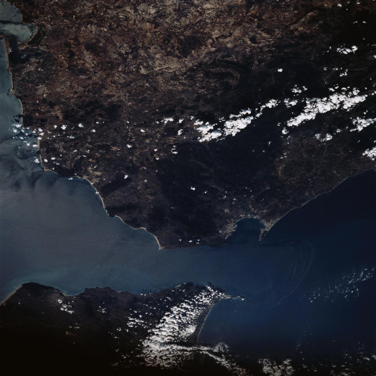
STS-56 Earth observation taken aboard Discovery, Orbiter Vehicle (OV) 103, is of the Strait of Gibraltar. A small bank of clouds marks the passage between Spain and Morocco at the western edge of the Mediterranean Sea. This passage, one of the two Pilars of Hercules of the Ancient Greeks, is now known as the Strait of Gibraltar. The cities of Cadiz on the Atlantic Coast of Spain and Malaga on the Mediterranean coast, as well as Tangier, Morocco (facing the strait), can be seen. According to NASA scientists studying the STS-56 photos, a subtle difference in the water color on the Atlantic side suggests that a pulse of surface water had recently flowed out of the Mediterranean into the Atlantic.
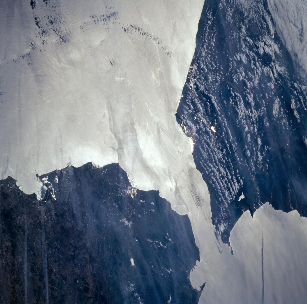
STS058-73-009 (18 Oct-1 Nov 1993) --- Atlantic water flowing with the tide through the Strait of Gibraltar into the Mediterranean generates internal waves as depicted in this photo. The incoming cool, less dense Atlantic water flows over the warm, more saline Mediterranean water. As the tide moves into the Strait of Gibraltar it encounters the Camarinal Sill, which is like a cliff under water, south of Camarinal Point, Spain. Internal waves are generated at the Sill and travel along the density boundary between the Atlantic water and the Mediterranean water. Internal waves have very little effect on the sea surface, except for gentle slopes and slight differences in roughness. We can see them in the Space Shuttle photos because of sunglint which reflects off the water. Internal waves smooth out some of the capillary waves at the surface in bands. The sun reflects more brightly from these smooth areas showing us the pattern of the underwater waves. The Bay of Cadiz on the southwest coast of Spain, the Rock of Gibraltar, and the Moroccan coast are also visible in this photo.
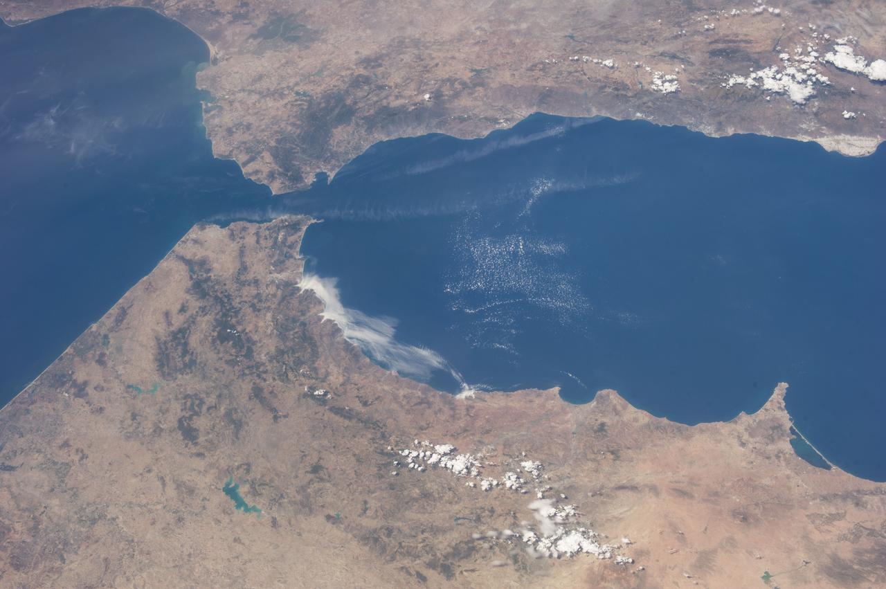
Swift currents flow through the Strait of Gibraltar, producing complicated patterns in the surface waters. Some of those patterns are highlighted in the sunglint in this photograph. The Mediterranian Sea is on the upper right, the Atlantic Ocean in in the lower left. Few features can be seen on the Mediterranian side, but current shears (straight lines coming off Spain), several sets of internal waves (impinging on the Spanish continental shelf) and ship wakes can be seen on the Atlantic side, west of Cadiz. Both Tangier and Cadiz show up in the sunglint as well.
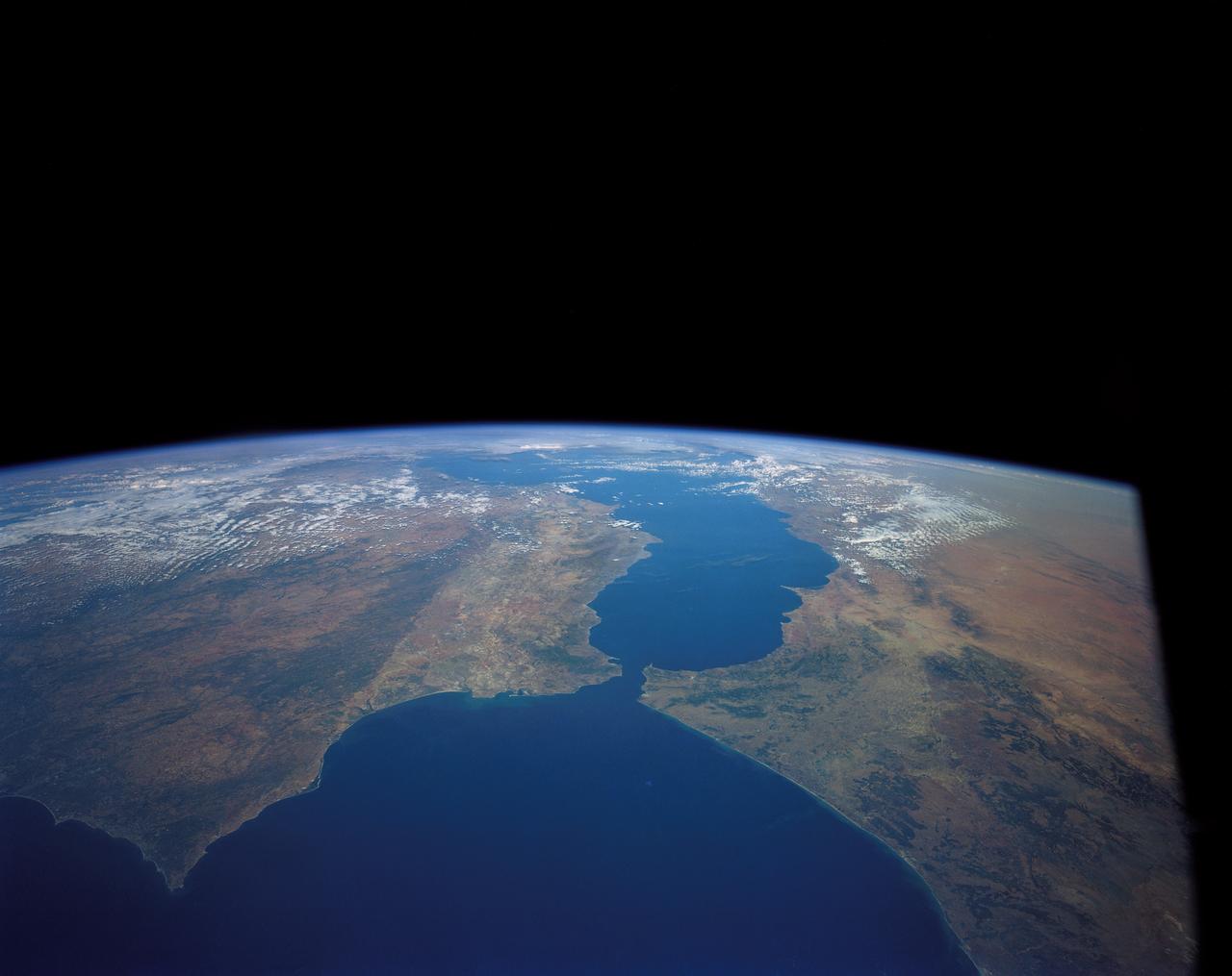
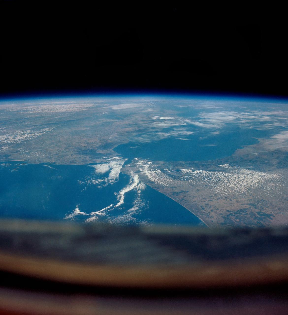
SL2-05-370 (22 June 1973) --- Gateway to the Atlantic, since ancient times the Strait of Gibraltar (36.5N, 4.5W) is also the border between Africa and Europe. In Spain to the north, the dark area near the coast is the delta of the Guadalquivir River and the city of Seville. The small spike of land on the north side of the strait is the actual Rock of Gibraltar. On the African side, a cloud front cutting across from the coast is blowing into Europe from Morocco and Algeria. Photo credit: NASA
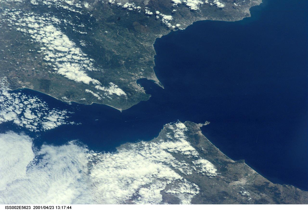
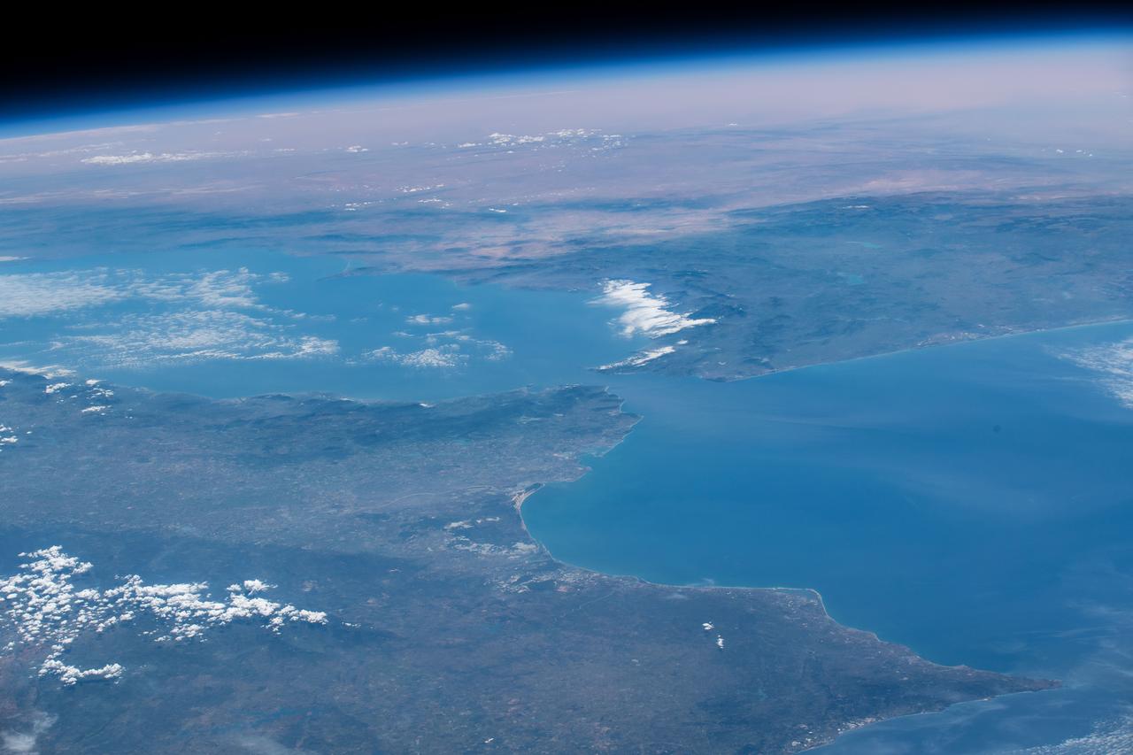
ISS002-E-5623 (23 April 2001) --- The Strait of Gibraltar, with part of Spain and all of Gibraltar at upper left and upper center, respectively, and portions of Morocco at bottom, was photographed with a digital still camera by the Expedition Two crew onboard the International Space Station (ISS).
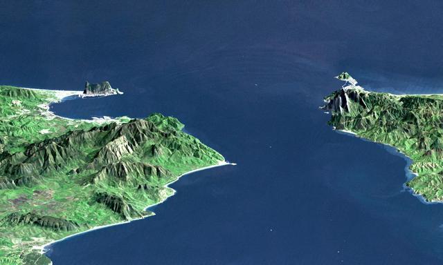
This perspective view shows the Strait of Gibraltar, which is the entrance to the Mediterranean Sea from the Atlantic Ocean. Europe (Spain) is on the left. Africa (Morocco) is on the right. The Rock of Gibraltar, administered by Great Britain, is the peninsula in the back left. The Strait of Gibraltar is the only natural gap in the topographic barriers that separate the Mediterranean Sea from the world's oceans. The Sea is about 3700 kilometers (2300 miles) long and covers about 2.5 million square kilometers (one million square miles), while the Strait is only about 13 kilometers (8 miles) wide. Sediment samples from the bottom of the Mediterranean Sea that include evaporite minerals, soils, and fossil plants show that about five million years ago the Strait was topographically blocked and the Sea had evaporated into a deep basin far lower in elevation than the oceans. Consequent changes in the world's hydrologic cycle, including effects upon ocean salinity, likely led to more ice formation in polar regions and more reflection of sunlight back to space, resulting in a cooler global climate at that time. Today, topography plays a key role in our regional climate patterns. But through Earth history, topographic change, even perhaps over areas as small as 13 kilometers across, has also affected the global climate. This image was generated from a Landsat satellite image draped over an elevation model produced by the Shuttle Radar Topography Mission (SRTM). The view is eastward with a 3-times vertical exaggeration to enhance topographic expression. Natural colors of the scene (green vegetation, blue water, brown soil, white beaches) are enhanced by image processing, inclusion of some infrared reflectance (as green) to highlight the vegetation pattern, and inclusion of shading of the elevation model to further highlight the topographic features. Landsat has been providing visible and infrared views of the Earth since 1972. SRTM elevation data matches the 30-meter (99-feet) resolution of most Landsat images and will substantially help in analyses of the large Landsat image archive. Elevation data used in this image was acquired by the Shuttle Radar Topography Mission (SRTM) aboard the Space Shuttle Endeavour, launched on February 11, 2000. http://photojournal.jpl.nasa.gov/catalog/PIA03397
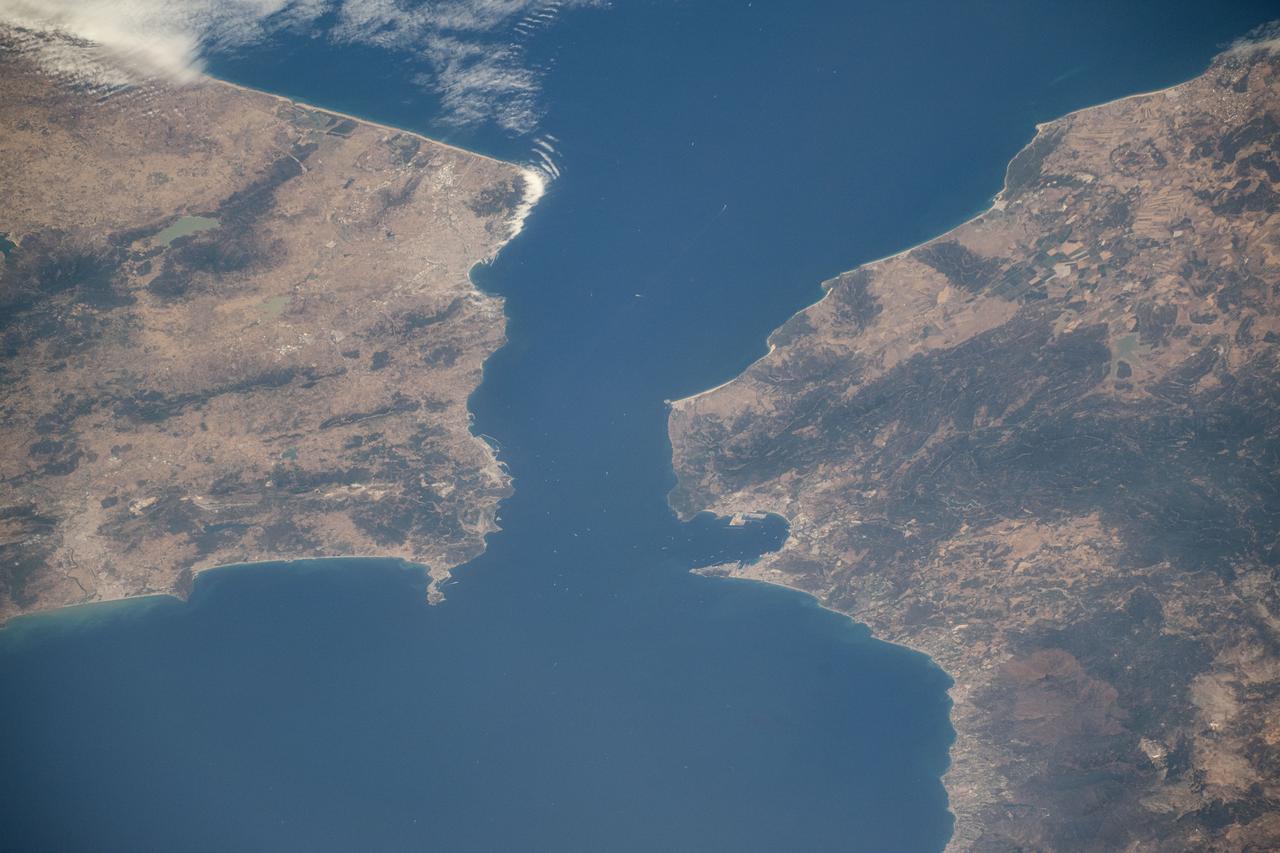
iss071e414110 (July 30, 2024) -- The Strait of Gibraltar separates Morocco (left) and Spain (right) while connecting the Atlantic Ocean to the Mediterranean Sea. The narrow strait spans only ~8 miles (~13 kilometers) between the two countries. As the International Space Station soared 258 miles above, NASA astronaut Matthew Dominick captured this photo.
41G-120-082 (5-13 Oct. 1984) --- This High oblique view was photographed with a medium format camera aboard the Earth-orbiting space shuttle Challenger. It features the Strait of Gibraltar and the Mediterranean Sea. Unlike vertical photographs from this area taken by crews of previous spaceflights, this oblique view allows extensive viewing into Spain and Morocco. Photo credit: NASA
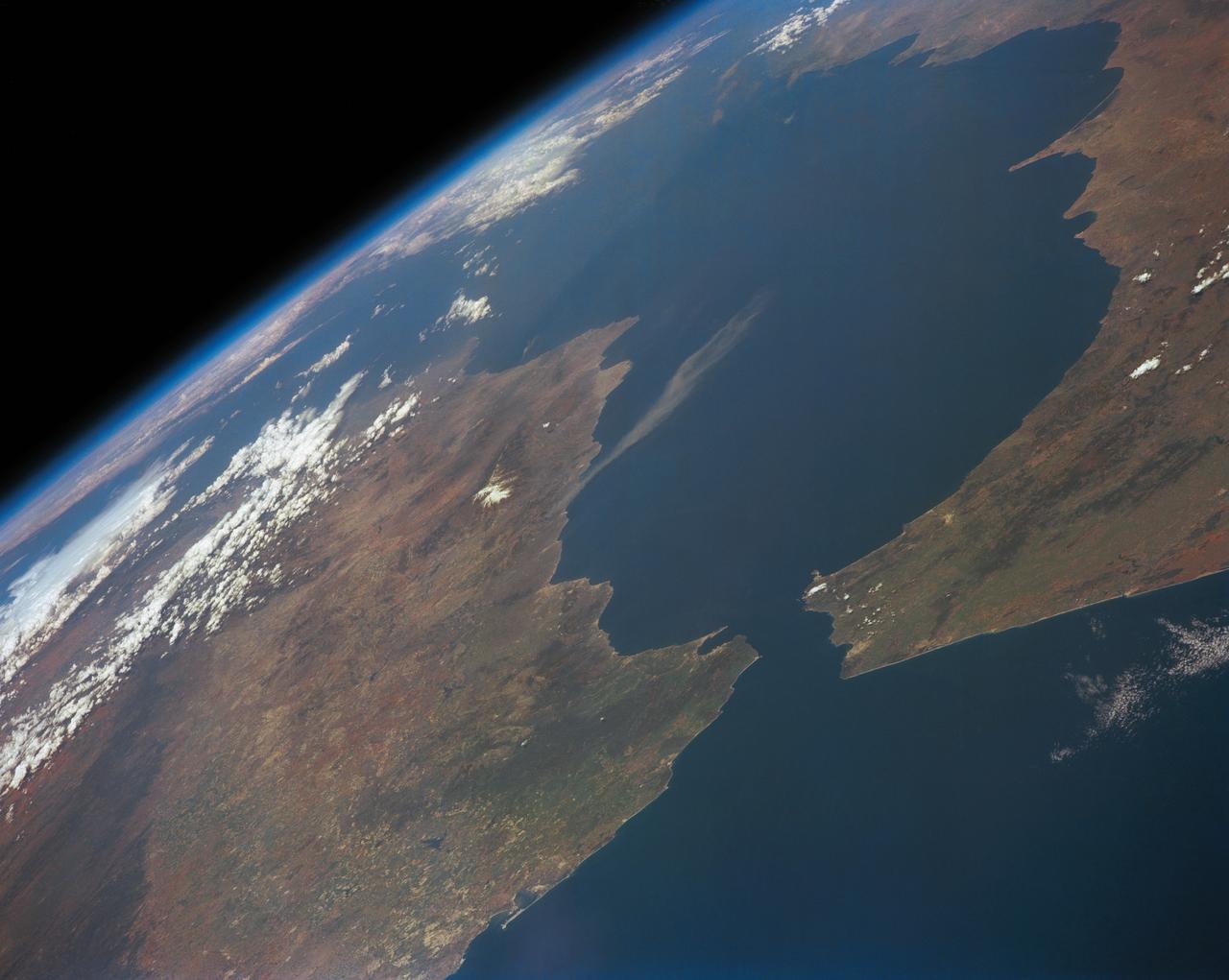
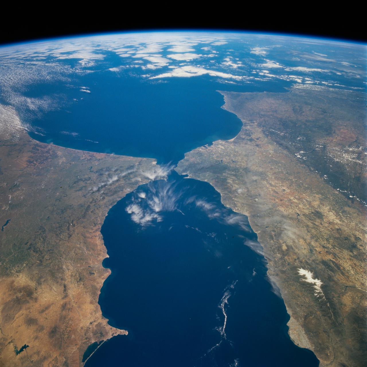
STS039-151-193 (28 April-6 May 1991) --- The Strait of Gibraltar, the only outlet for the Mediterranean Sea, was photographed with a large format handheld camera by the STS-39 crew members. Scientists site evidence in Shuttle photography that the Mediterranean Sea dried up a number of times between 5 million and 20 million years ago. Sea levels, they say, dropped slightly, cutting off the Mediterranean (top right) from the Atlantic Ocean (bottom). In southern Spain, the dark area near the coast is the delta of the Guadalquivir River with the city of Seville. The Sierra Nevada range still has some snow. A small field fire near the Spanish coast has generated a conspicuous smoke plume. The small spike of land on the north side of the Strait is the Rock of Gibraltar, an outpost of the British empire. The larger spike of land on the north coast of Africa marks the border between Morocco (center foreground) and Algeria (right). The sharp line cutting across them Mediterranean (top right) marks the edge of a dust cloud blowing from Africa into Europe. Photo credit: NASA
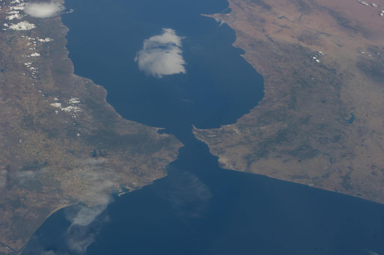
iss071e217183 (June 25, 2024) -- As the International Space Station orbited 263 miles above Earth, NASA astronaut Butch Wilmore captured this image of Spain and Morocco. The Strait of Gibraltar separates the two countries and connects the Atlantic Ocean to the Mediterranean Sea.
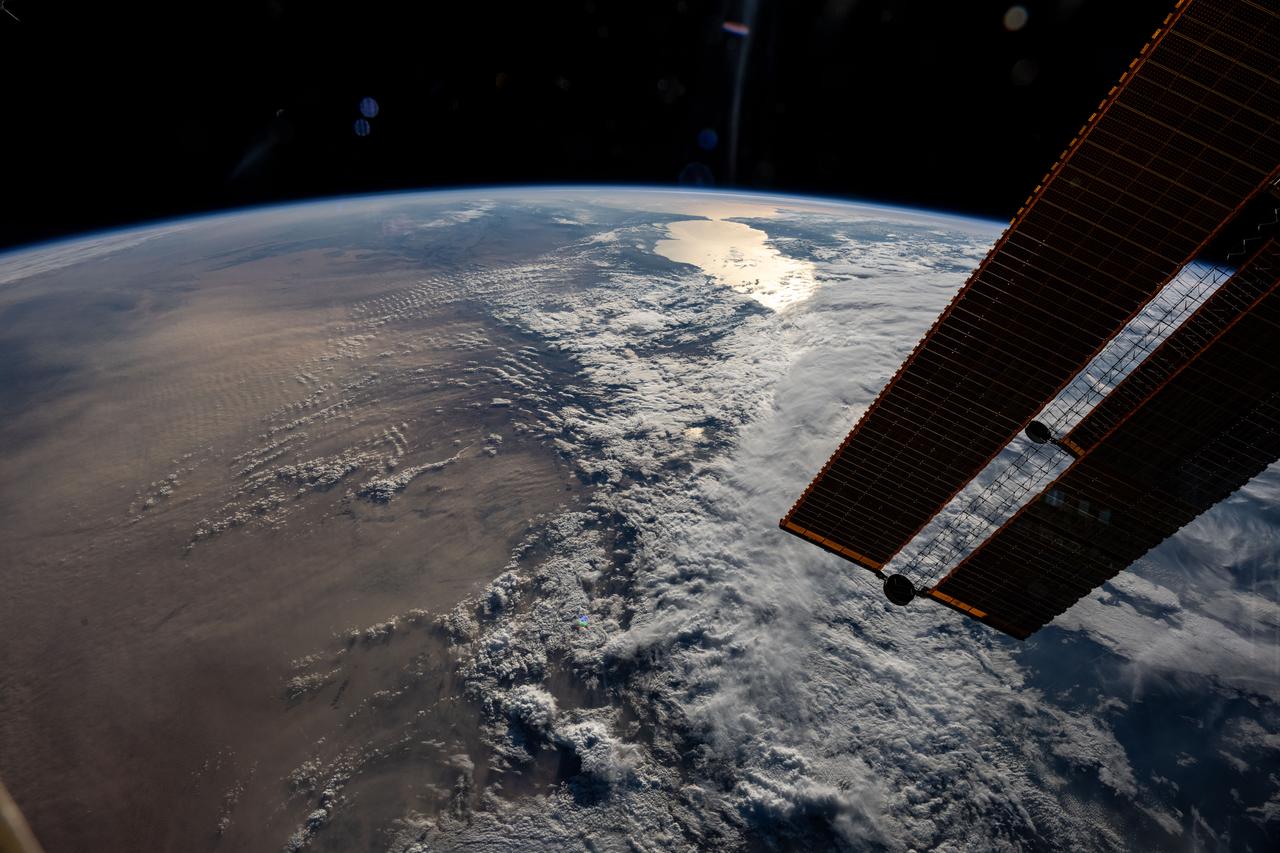
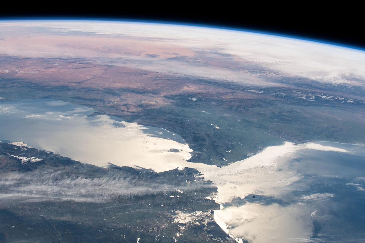
iss073e0032281 (May 15, 2025) --- The sun's glint beams off the Strait of Gibraltar at the top of this photograph as the International Space Station orbited 261 miles above a cloudy Mediterranean Sea. At left, is the Sahara Desert extending across the north African continent. In the right foreground, is a set of of the orbital outpost's main solar arrays.
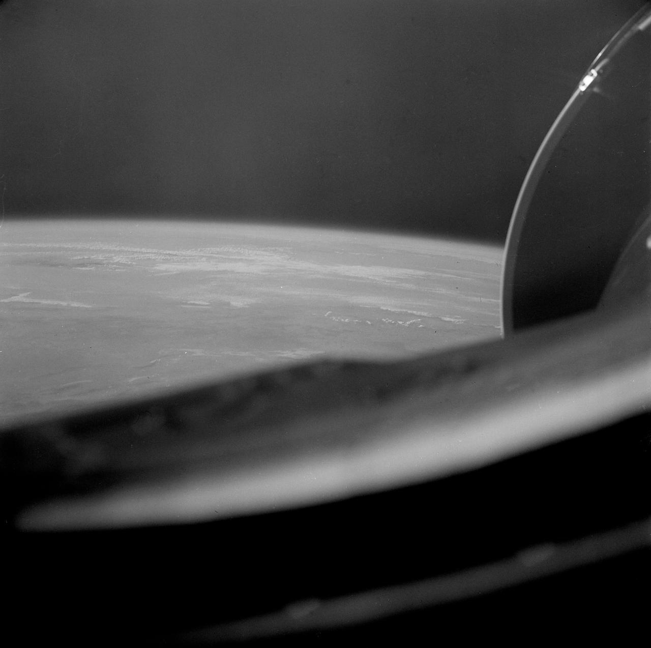
S65-45737 (22 Aug. 1965) --- Looking northeast, the Strait of Gibraltar, Morocco (foreground) and Spain (background) are photographed from the Gemini-5 spacecraft during its 14th revolution of Earth.

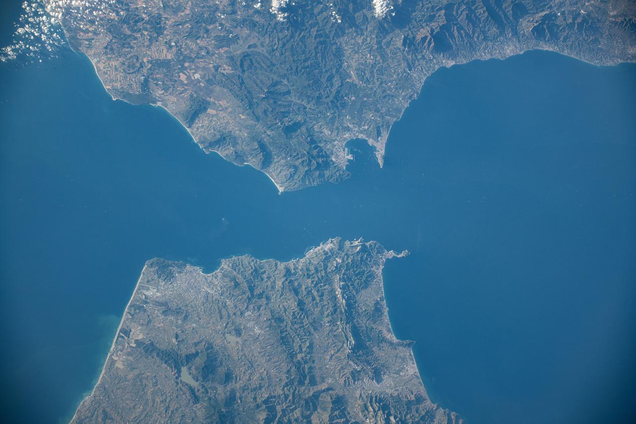
ISS002-E-5627 (23 April 2001) --- Algecira (left), the Bay of Gibraltar (Bahia de Algecira) and "The Rock of Gibraltar" (right) are featured in this detailed vertical view on the European side of the Strait of Gibraltar. Ship traffic in the Bay and Gibraltar Dock Yard can easily be seen. This digital still camera's image is part of a series of pictures centering on the Strait of Gibraltar area which was recorded by the ISS Expedition Two crew on April 23, 2001.
STS077-718-088 (19-29 May 1996) --- A popular photographic target of Space Shuttle astronauts has always been the Strait of Gibraltar seen at center in this wide photograph, shot from the Space Shuttle Endeavour. Spain is to the north (right) and Morocco to the south. The strait is 36 miles (58 kilometers) long and narrows to 8 miles (13 kilometers) at it’s most narrow point. The winds in the strait are either easterly or westerly. The British colony of Gibraltar is the semi-circular feature north of the strait. Gibraltar is considered to be one of the Pillars of Hercules. The white colored area to the southeast of Gibraltar on the Moroccan coast is the city of Tanger (Tangier). The snow covered mountains in Spain are the Sistemas Penibeticos.
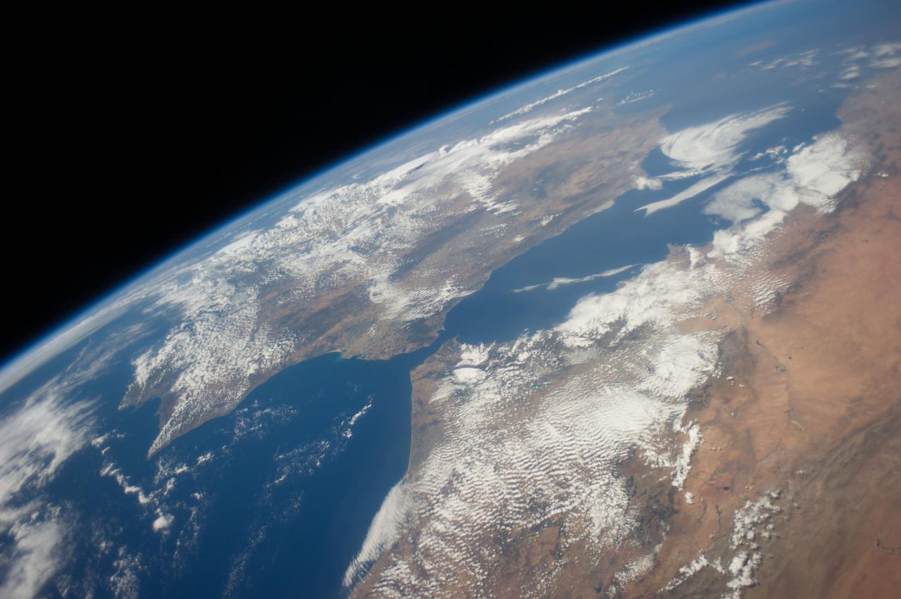
ISS036-E-036611 (23 Aug. 2013) --- One of the Expedition 36 crew members aboard the International Space Station on Aug. 23 exposed this image of the Strait of Gibraltar, where Europe and Africa meet and where the Atlantic Ocean waters flow through the strait into the Mediterranean Sea. A popular photographic target of astronauts has always been the Strait of Gibraltar, easily spotted at left center in this wide photograph, shot from the International Space Station. Spain is to the north (top) and Morocco to the south. The strait is 36 miles (58 kilometers) long and slims down to 8 miles (13 kilometers) at it?s most narrow point. The British colony of Gibraltar is north of the strait.
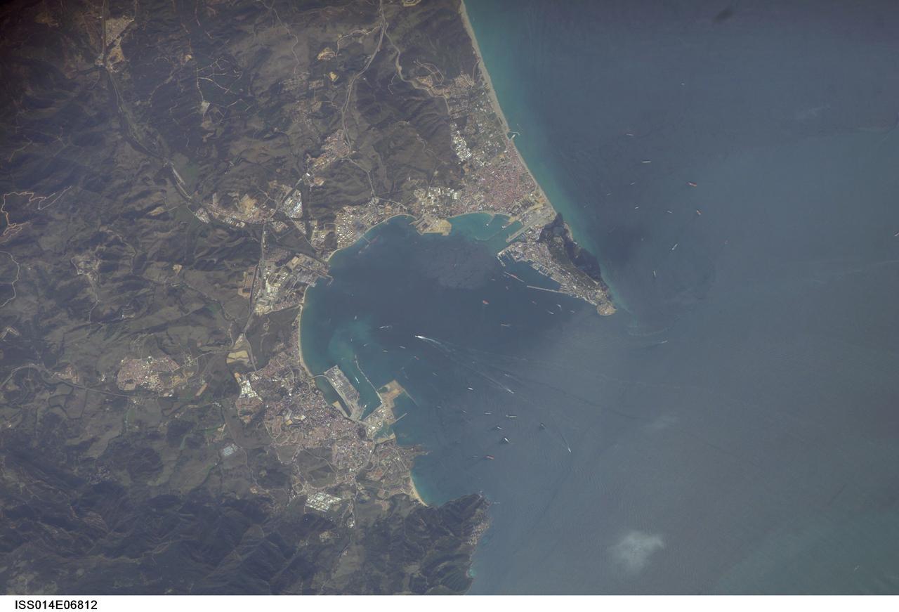
ISS014-E-06812 (30 Oct. 2006) --- Gibraltar Bay, located near the southernmost tip of the Iberian Peninsula in the western Mediterranean Sea, is featured in this image photographed by an Expedition 14 crewmember on the International Space Station. According to scientists, the famous Rock of Gibraltar that forms the northeastern border of the Bay is formed of Jurassic seafloor sediments that were lithified to form limestone (a rock formed predominantly of the mineral calcite) and subsequently uplifted as a result of collision of the African and Eurasian tectonic plates. The cities of La Linea and Algeciras bordering the Bay -- together with petroleum-processing facilities along the northern Bay shoreline -- are part of Spain, whereas the city of Gibraltar itself (to the west of and including the Rock) is under the jurisdiction of the United Kingdom. The protected waters of the Bay and its proximity to Africa and the Strait of Gibraltar as the gateway between the Atlantic and Mediterranean contribute to the region's past and current strategic and economic importance. Numerous ships and several ship wakes are visible within the Bay; the majority of these are freighters and cargo tankers accessing the petroleum facilities. Ships nearer to the Rock are more likely cruise ships, as Gibraltar is a popular destination for tourists. Partial sunglint within the Bay highlights surface water roughened by winds funneled into the Bay by the surrounding highlands -- one such area is visible directly to the west of La Linea.
ISS040-E-081001 (25 July 2014) --- One of the Expedition 40 crew members aboard the Earth-orbiting International Space Station was aiming his camera almost straight down when he recorded this view of parts of Spain (top), Morocco (bottom) and the Strait of Gibraltar (center) at 08:04:35 GMT on July 25, 2014. Gibraltar and the Alboran Sea are on the right side of the frame. Cadiz, Spain is almost under clouds on the Bay of Cadiz above and to the left of frame center.

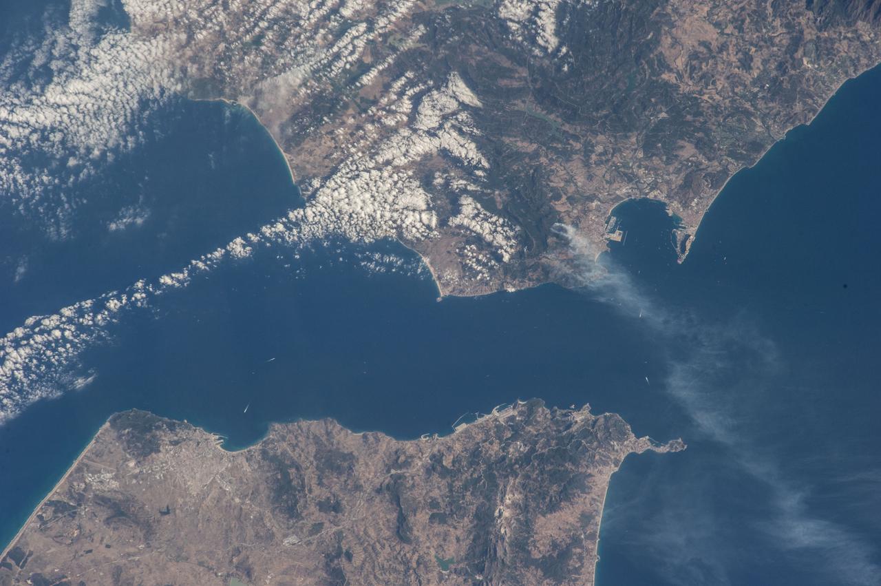
iss056e127068 (Aug. 6, 2018) --- The International Space Station was orbiting off the coast of Portugal when an Expedition 56 crew member photographed wildfires near its southern coast and the Strait of Gibraltar which separates Spain on the European continent from Morocco on the African continent. The North Atlantic Ocean connects to the Strait of Gibraltar which leads into the Mediterranean Sea.
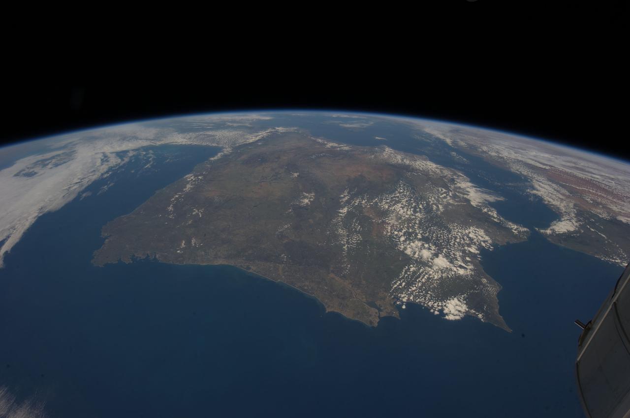
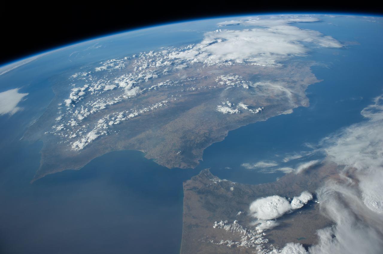
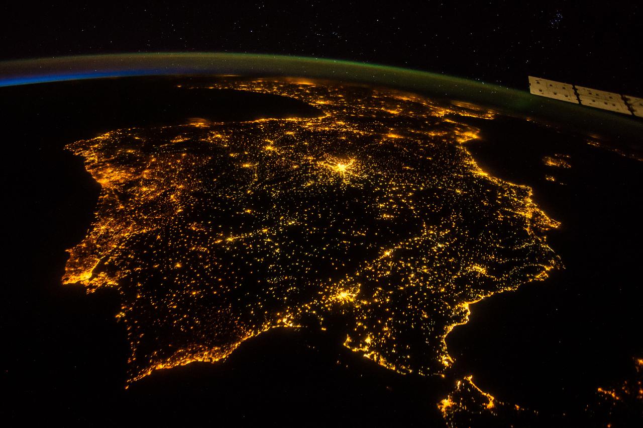
ISS035-E-027420 (23 April 2013) --- One of the Expedition 35 crew members aboard the International Space Station photographed this high oblique image of the Iberian Peninsula on April 23, 2013. This is one of the very few pictures in the history of the decades old NASA-managed human-tended space program that shows the entire peninsula, with Portugal, Spain and Gibraltar. The Strait of Gibraltar (right center) is a narrow strait that connects the Atlantic Ocean to the Mediterranean Sea and separates Gibraltar and Spain in Europe from Morocco (far right center)in Africa. Europe and Africa are separated by 7.7 nautical miles (14.3 kilometers or 8.9 statute miles) of ocean at the strait's narrowest point. A small part of France is barely visible at the horizon (top center).
ISS040-E-011996 (14 June 2014) --- One of the Expedition 40 crew members aboard the Earth-orbiting International Space Station recorded this image of the Strait of Gibraltar, showing parts of Morocco and Spain, on June 14, 2014.
S66-45749 (18 July 1966) --- Straits of Gibraltar, Mediterranean Sea, Spain in background, Algeria and Morocco in foreground as seen from Gemini-10 spacecraft. Photo credit: NASA
ISS040-E-010889 (12 June 2014) --- One of the Expedition 40 crew members aboard the Earth-orbiting International Space Station recorded this image of the Strait of Gibraltar, showing parts of Morocco and Spain, on June 12, 2014.
Earth observation taken during a night pass by the Expedition 43 crew aboard the International Space Station (ISS). Folder lists this as time lapse From Gibraltar NE-bound.
41G-34-098 (5-13 Oct 1984) --- Strait of Gibraltar and western Mediterranean photographed sunglint. Sun reflection on water delineates surface texture, which corresponds to the ocean's dynamics. The large group of waves connecting Gibraltar with the Moroccan coast is the response of the ocean to a tidal pulse moving into the Mediterranean. The low level wing shear line extending out from the Moroccan coastline into the Mediterranean for approximately 40 miles is the southern extremity of the wind funneling through the strait. This is the first high resolution photograph ever taken of this phenomenon permitting detailed delineation of individual waves which comprise the wave packet.
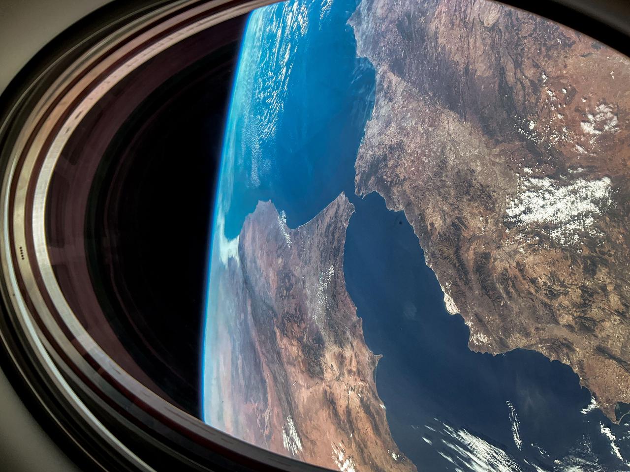
iss069e086298 (Aug. 27, 2023) --- This view of Earth was captured from a window on the SpaceX Dragon Endurance spacecraft as it approached the International Space Station. Pictured below is the Strait of Gibraltar that connects the Atlantic Ocean to the Mediterranean Sea, which separates the continents of Europe and Africa.
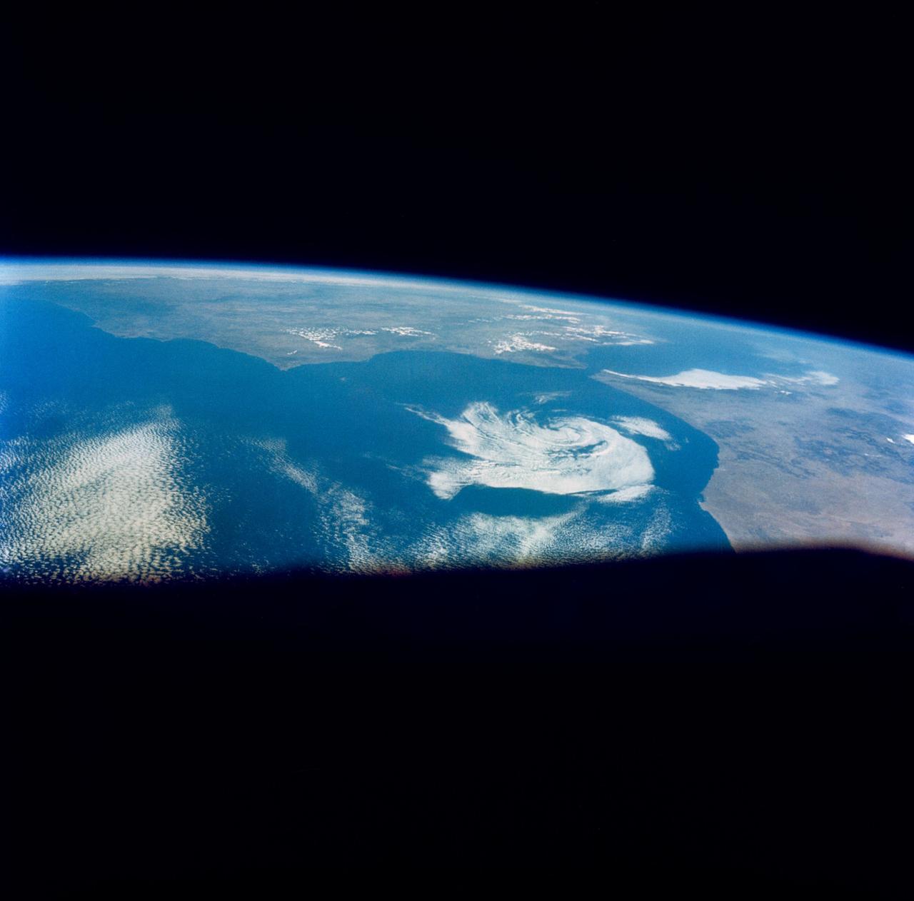
S66-46044 (18-21 July 1966) --- Straits of Gibraltar and Spain ? Portugal (left), Morocco (right), Atlantic Ocean (foreground), and unique vortex, as seen from the Gemini-10 spacecraft. Taken with J.A. Maurer 70mm camera, using Eastman Kodak, Ektachrome, MS (S.O. 217) color film. Photo credit: NASA
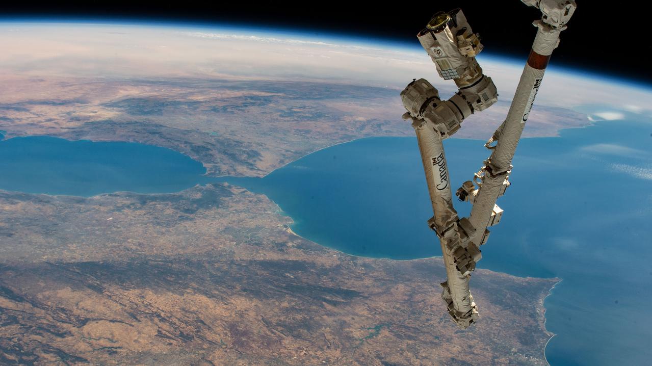
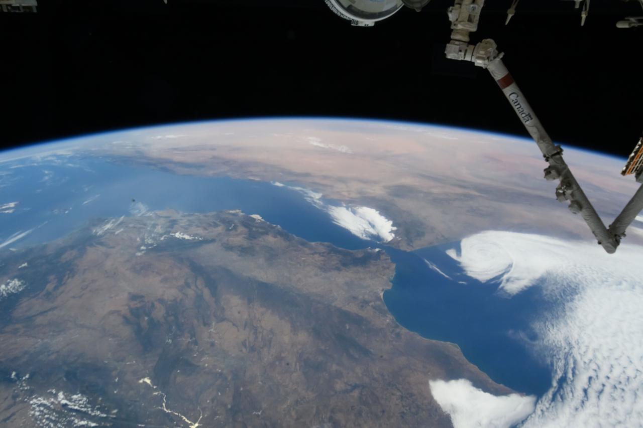
iss067e270597 (Aug. 18, 2022) --- The Canadarm2 robotic arm extends from the International Space Station, orbiting 259 miles above the northern coast of Spain, in this photograph of the Strait of Gibraltar which separates the Atlantic Ocean (right) from the Mediterranean Sea and the European nation of Spain (bottom) from the African country of Morocco.
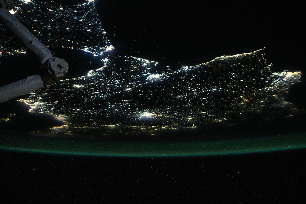
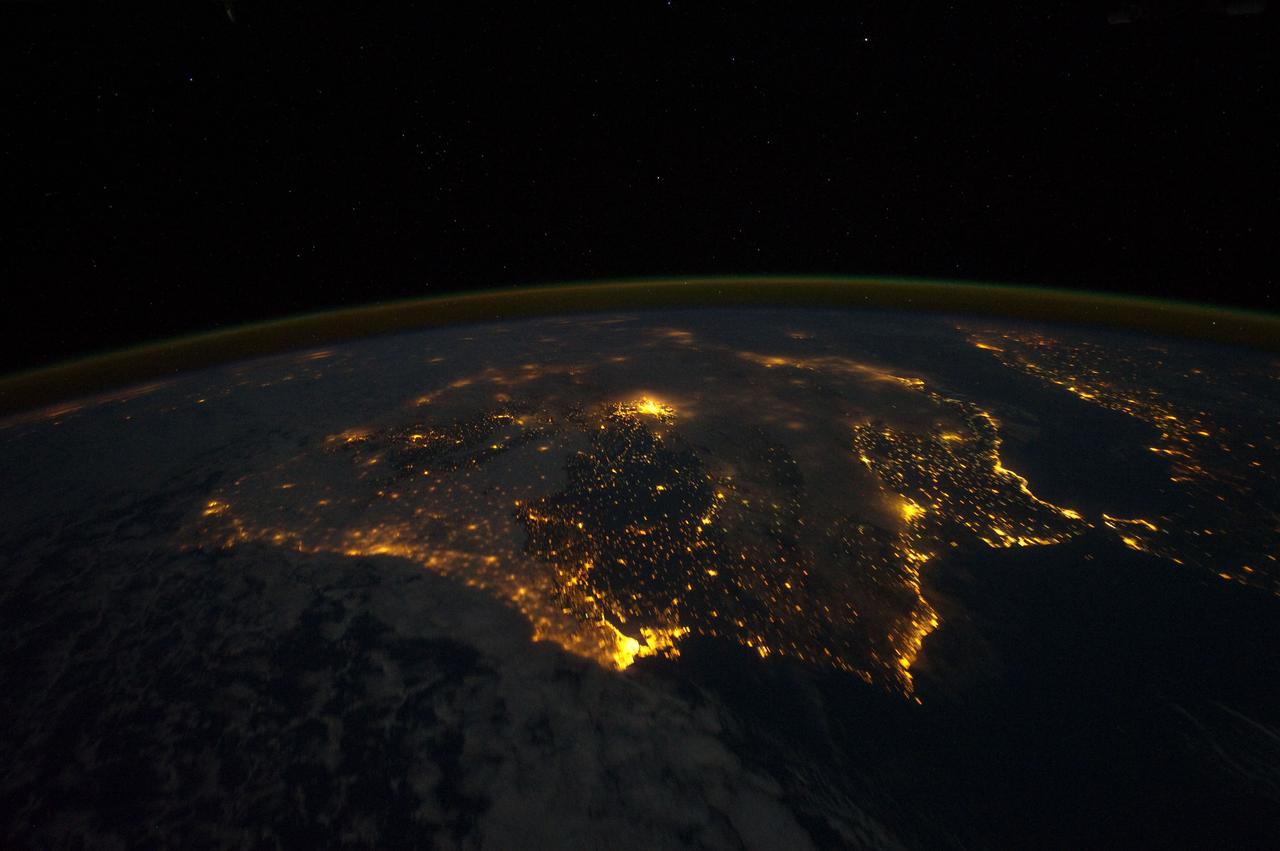
iss073e0686324 (Aug. 30, 2025) --- The nighttime coastal lights of Morocco and Spain, where the Atlantic Ocean meets the Mediterranean Sea at the Strait of Gibraltar, are pictured at approximately 1:36 a.m. local time as the International Space Station orbited 260 miles above the Moroccan coast.
iss062e005579 (Feb. 11, 2020) --- The Strait of Gibraltar connects the Atlantic Ocean with the Mediterranean Sea and separates Spain on the European continent from Morocco on the African continent. The International Space Station was orbiting 265 miles above the Atlantic off the coast of Lisbon, Portugal, when this photograph was taken.
iss059e038134 (April 30, 2019) --- Looking from northwest to southeast (bottom to top), this oblique view shows portions of Western Europe, the Atlantic Ocean, the Mediterranean Sea and North Africa. More specific regions such as Portugal, Spain, the Strait of Gibraltar, Morocco and Algeria are seen as the International Space Station orbited 257 miles above the Atlantic.
ISS040-E-016324 (20 June 2014) --- One of the Expedition 40 crew members aboard the Earth-orbiting International Space Station recorded this oblique panorama of the Strait of Gibraltar, showing parts of Morocco and Spain, on June 20, 2014.
ISS047e001308 (03/02/2016) --- Europe meets Africa in this Earth Observation image captured by NASA astronaut Tim Peake. He tweeted this message out with the photo " Strait of Gibraltar - 9 miles separating #Europe and #Africa . @Space_Station #Explore ".
iss071e082829 (May 16, 2024) --- The Strait of Gibraltar separates the European nation of Spain from the African nation of Morocco and connects the Atlantic Ocean with the Medirrranean Sea. The International Space Station was orbiting 259 miles above North Africa at the time of this photograph.
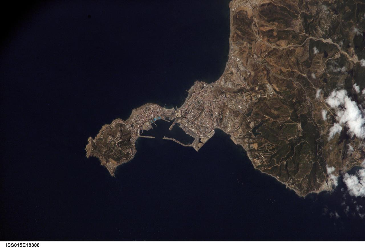
ISS015-E-18808 (21 July 2007) --- Ceuta on the northern African coastline is featured in this image photographed by an Expedition 15 crewmember on the International Space Station. The small Spanish enclave of Ceuta occupies a narrow isthmus of land on the African side of the Strait of Gibraltar. This view illustrates the sharp contrast in land cover between urban Ceuta (pink to white residential and industrial rooftops at center), the bay formed by seawalls to the north of the city, and the higher elevations of Monte Hacho forming the end of the isthmus. Green, vegetated slopes surround the Spanish fort atop the mountain, which commands a clear view of the Strait of Gibraltar to the northwest (not shown). Several small dots are visible near the coastline to the northwest and south of Ceuta -- these are small pleasure or fishing boats.
STS059-238-074 (9-20 April 1994) --- The Atlantic Ocean, Straits of Gibraltar, and Alboran Sea (the westernmost portion of the Mediterranean Sea) separate Spain on the left from Morocco on the right. Algeciras Harbor is the prominent notch cut out of the eastern end of the north shore of the Strait; the Rock of Gibraltar is the tiny arrowhead that separates the notch from the Alboran Sea. The Sierra Nevada, farther away down the Spanish coast, lives up to its name in this April scene. The difference in elevation between the Sierra Morena and the Guadalquivir River valley is highlighted nicely by cumulus clouds. Tangier, Morocco can be seen as a light-toned spot on the southern shore of the Strait, near the entrance to the Atlantic Ocean. Hasselblad photograph.
ISS040-E-081305 (26 July 2014) --- One of the Expedition 40 crew members aboard the International Space Station recorded this early evening photo showing part of the Cygnus cargo carrier built by Orbital Sciences Corp. as well as almost the entire Iberian Peninsula (Spain, and Portugal) on July 26, 2014. Part of northern Africa is visible at lower right, and the Strait of Gibraltar can be seen right of center frame.
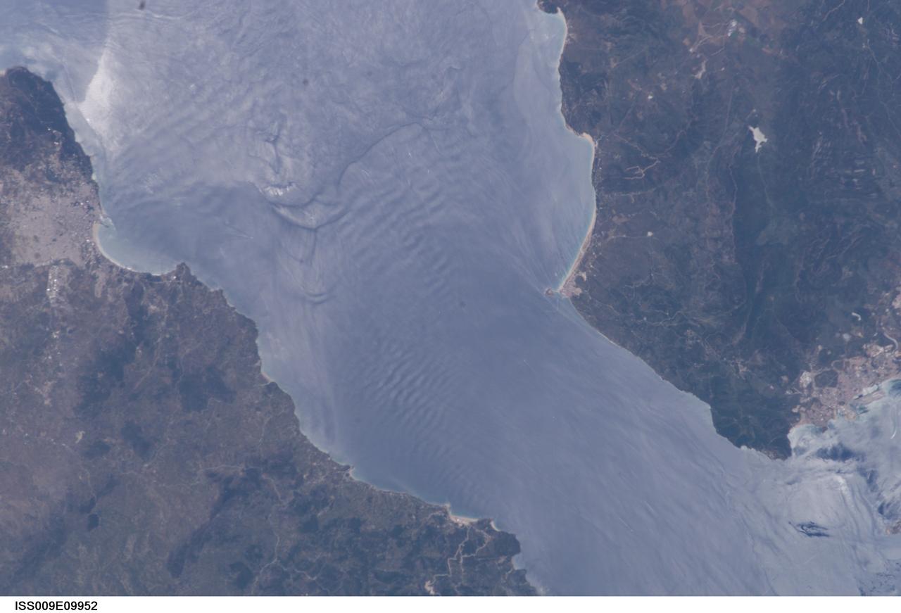
ISS009-E-09952 (3 June 2004) --- Large internal waves in the Strait of Gibraltar are featured in this scene photographed by an Expedition 9 crewmember on the International Space Station (ISS). These subsurface internal waves occur at depths of about 100 meters, but appear in the sun glint as giant swells flowing eastward into the Mediterranean Sea. This image was merged with image ISS009-E-09954 to create a mosaic, which can be viewed on http://eol.jsc.nasa.gov.
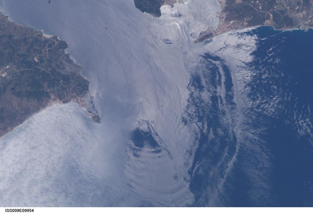
ISS009-E-09954 (3 June 2004) --- Large internal waves in the Strait of Gibraltar are featured in this scene photographed by an Expedition 9 crewmember on the International Space Station (ISS). These subsurface internal waves occur at depths of about 100 meters, but appear in the sun glint as giant swells flowing eastward into the Mediterranean Sea. This image was merged with image ISS009-E-09952 to create a mosaic, which can be viewed on http://eol.jsc.nasa.gov.
ISS040-E-105800 (23 Aug. 2014) --- One of the Expedition 40 crew members aboard the International Space Station, flying at an altitude of 220 nautical miles, recorded this oblique panorama showing almost the entire Iberian Peninsula (Spain and Portugal) at right, Morocco and other parts of Africa (left) and the Strait of Gibraltar (top center) on Aug. 23, 2014. A 28mm focal length was used.
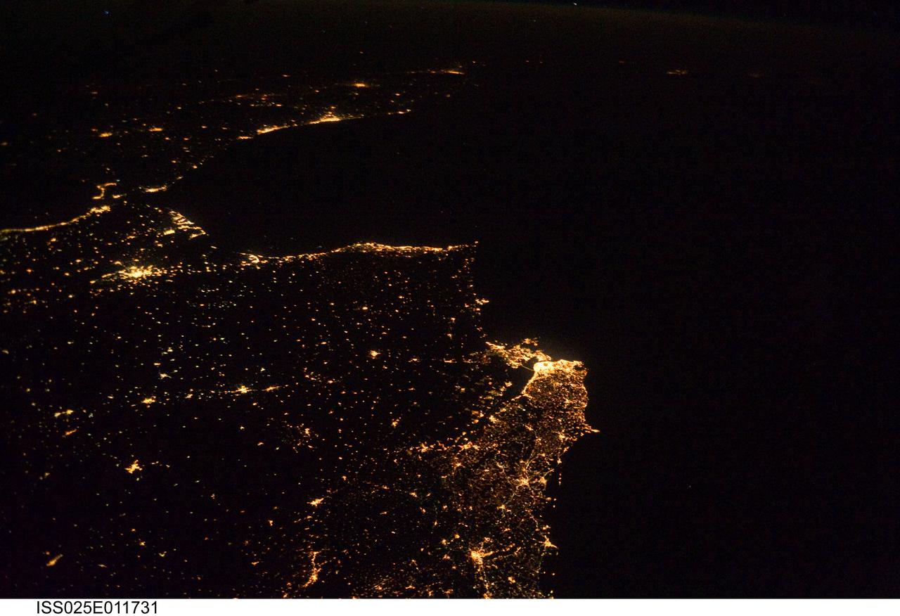
ISS025-E-011731 (5 Nov. 2010) --- One of the Expedition 25 crew members aboard the International Space Station, 220 miles above Earth, took this night time photo, looking south along the Atlantic coast of Europe and into Africa, from Lisbon, Portugal south across the Strait of Gibraltar. The lights can be followed down the coast of Morocco to Casablanca, and beyond.
ISS030-E-030428 (31 Dec. 2011) --- This high oblique panorama shows Morocco and Spain as photographed by the Expedition 30 crew members aboard the International Space Station. The Atlantic Ocean, Straits of Gibraltar and Alboran Sea (the westernmost portion of the Mediterranean Sea) separate Spain on the right from Morocco on the left. Algeciras Harbor is the prominent notch cut out of the eastern end of the north shore of the Strait. A Russian spacecraft, docked to the orbital outpost, is in the upper left corner.
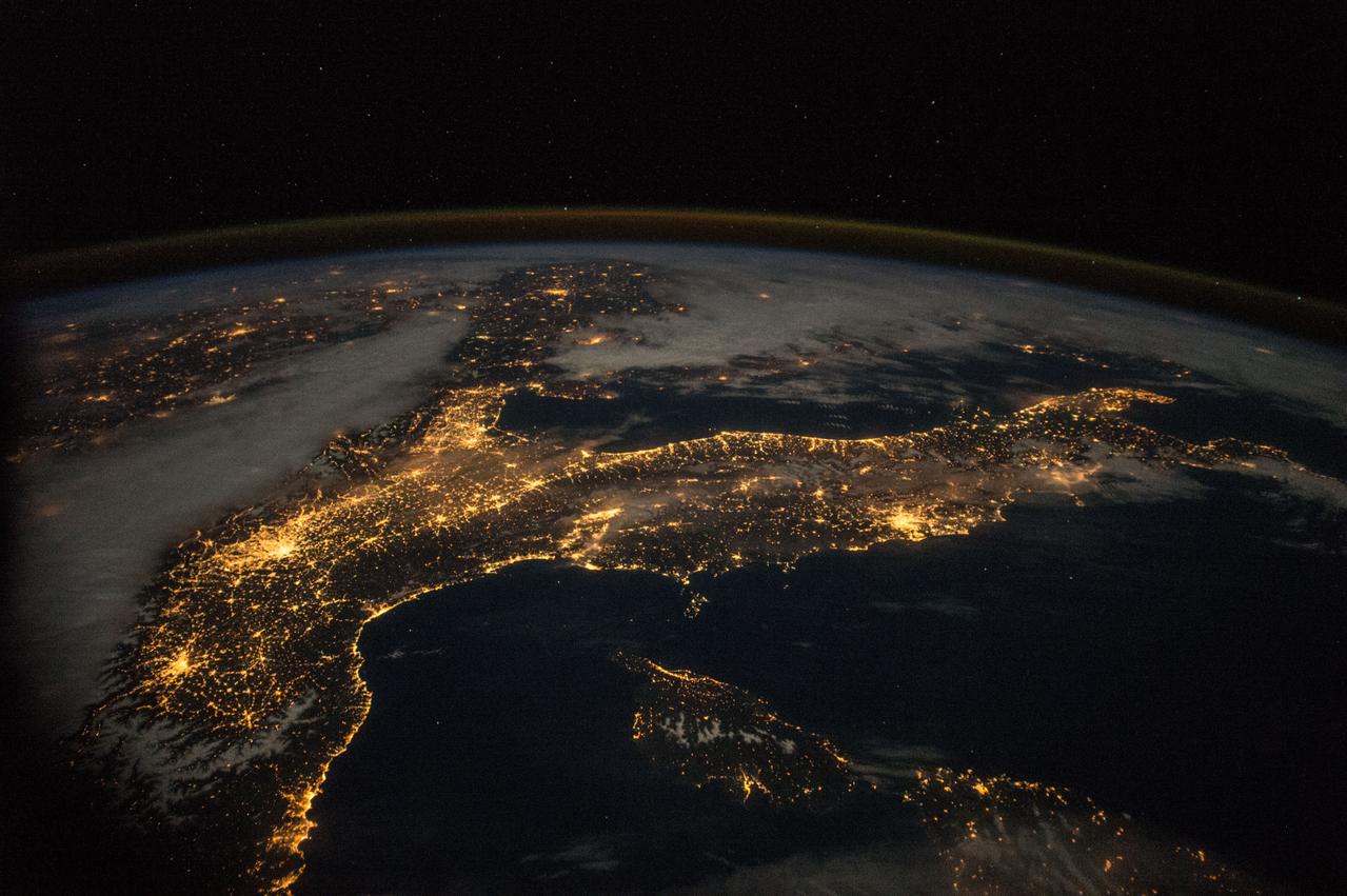
iss069e037776 (Aug. 8, 2023) --- This nighttime photograph shows the Mediterranean Sea ringed by the coastal city lights of Morocco and Algeria on the African side and Spain on the European side. The city lights extending to the Strait of Gibraltar and the Atlantic Ocean are also prominent. The International Space Station was orbiting 261 miles above the Balearic Sea off the coast of Mallorca at the time of this photograph.
ISS040-E-081320 (26 July 2014) --- One of the Expedition 40 crew members aboard the International Space Station recorded this early evening photo of the entire Iberian Peninsula (Spain and Portugal) on July 26, 2014. Part of France can be seen at the top of the image and the Strait of Gibraltar is visible at bottom, with a very small portion of Morocco visible near the lower right corner.
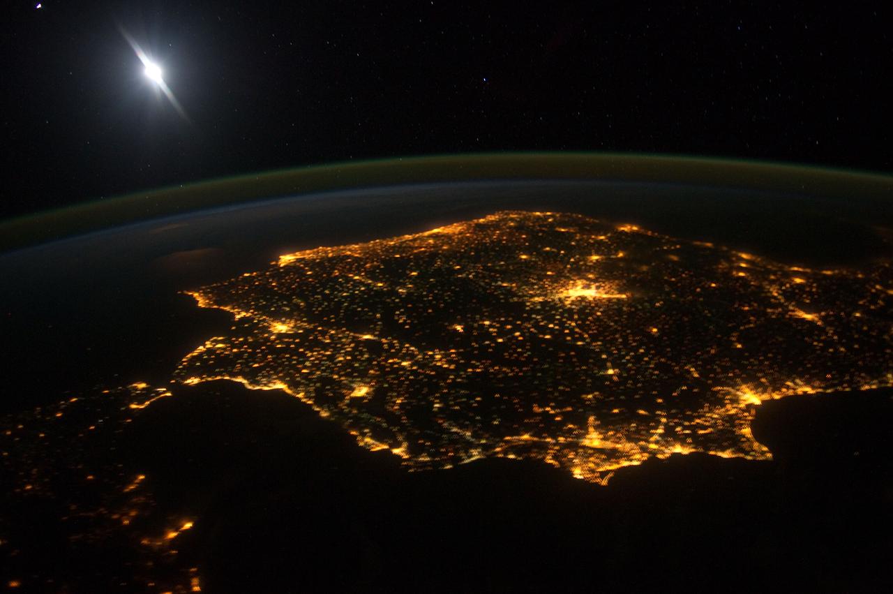
ISS030-E-060478 (30 Jan. 2012) --- The city lights of Madrid (just right of center) stand out in this photograph from the International Space Station. Recorded by one of the Expedition 30 crew members, the view shows almost the entire Iberian Peninsula (both Spain and Portugal) with the Strait of Gibraltar and Morocco appearing at lower left. What is thought to be a blur of the moon appears in upper left corner. The faint gold or brownish line of airglow?caused by ultraviolet radiation exciting the gas molecules in the upper atmosphere?parallels the horizon or Earth limb.

This artist's concept depicts the completely assembled International Space Station (ISS) passing over the Straits of Gibraltar and the Mediterranean Sea. As a gateway to permanent human presence in space, the Space Station Program is to expand knowledge benefiting all people and nations. The ISS is a multidisciplinary laboratory, technology test bed, and observatory that will provide unprecedented undertakings in scientific, technological, and international experimentation. Experiments to be conducted in the ISS include: microgravity research, Earth science, space science, life sciences, space product development, and engineering research and technology. The sixteen countries participating the ISS are: United States, Russian Federation, Canada, Japan, United Kingdom, Germany, Italy, France, Norway, Netherlands, Belgium, Spain, Denmark, Sweden, Switzerland, and Brazil.
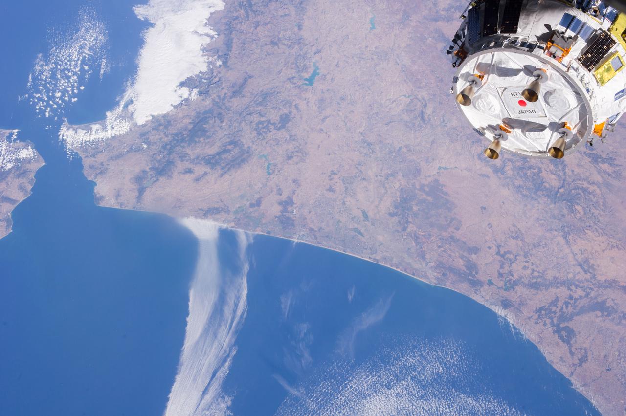
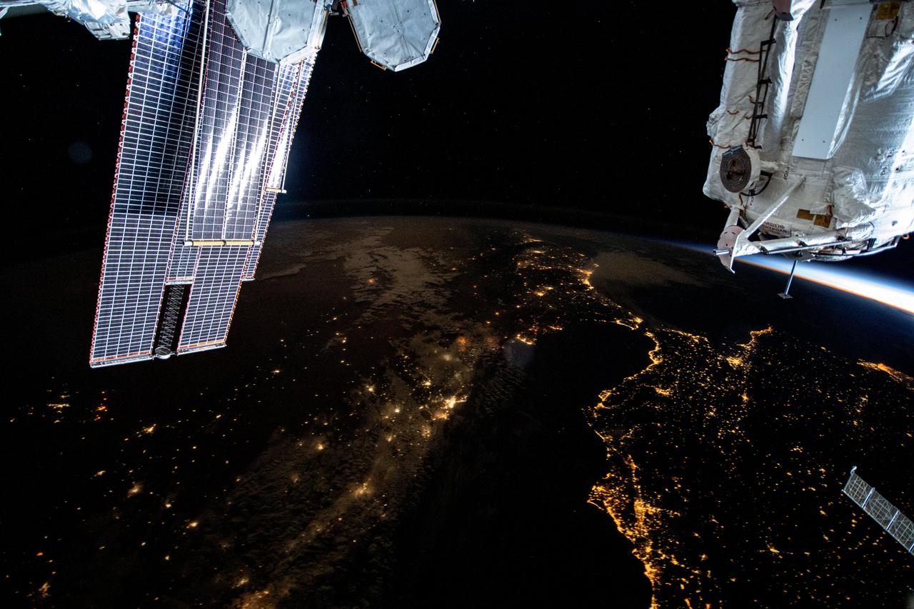
ISS036-E-039525 (04 Sept. 2013) --- One of the Expedition 36 crew members aboard the International Space Station took this picture showing part of the Japanese HTV-4 unmanned cargo spacecraft, backdropped against countries in northern Africa, following its unberthing from the orbital outpost. HTV-4, after backing away from the flying complex, headed for re-entry into Earth's atmosphere, burning upon re-entry. The Strait of Gibraltar, where the Atlantic Ocean and the Mediterranean Sea meet, is in the upper left quadrant of the photo. HTV-4 was launched by Japan?s Aerospace Exploration Agency (JAXA) on Aug. 4 of this year in order to bring up supplies for the astronauts and cosmonauts onboard the station.
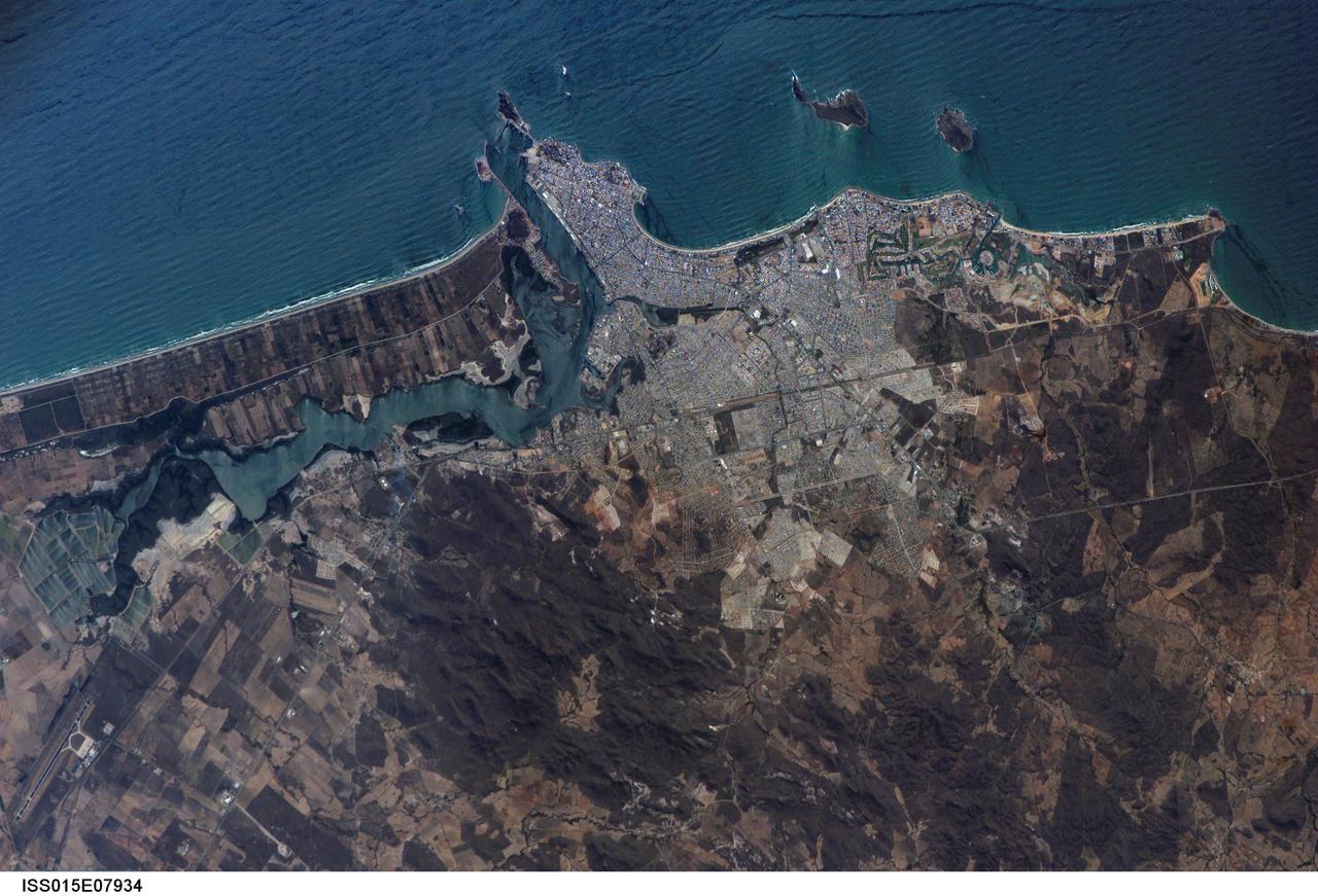
ISS015-E-07934 (13 May 2007) --- Mazatlan, Mexico is featured in this image photographed by an Expedition 15 crewmember on the International Space Station. Mazatlan is Mexico's largest port, situated on one of the best estuaries on Mexico's Pacific coast, illustrated well in this image. Docks and naval yards line the north side of the estuary. The city itself appears as a series of light-toned city blocks covering the center of the image. Mazatlan (population of 352,000 in 2005) is growing northward from the downtown peninsula, with tourist beaches backed by hotels, and a marina and golf courses just beyond. No city growth yet appears on the south side the estuary where farm lands can be seen. The famous Faro Lighthouse occupies the top of a steep island--now connected by a bridge to the mainland--at the mouth of the estuary (top center). The Faro Lighthouse is the second tallest in the world behind Gibraltar's. The wide, straight, almost vertical line of the railroad appears to bisect the picture. This image shows sea features well, primarily ocean swells coming in from the southwest, which appear as a series of parallel lines covering the entire sea surface in this view. An oil slick offshore of the tourist beaches appears as a dark line along the left side of the image.
ISS030-E-010008 (4 Dec. 2011) --- One of the Expedition 30 crew members aboard the Earth-orbiting International Space Station photographed this night time scene of the Iberian Peninsula on Dec. 4, 2011. The city lights of Spain and Portugal define the peninsula. Several large metropolitan areas are visible, marked by their relatively large and brightly lit areas, such as two capital cities -- Madrid, Spain, located near the center of the peninsula?s interior, and Lisbon, Portugal, located along the southwestern coastline. Ancient Seville, visible at image right to the north of the approximately 14 kilometer-wide Strait of Gibraltar, is one of the largest cities in Spain. All together, the Principality of Andorra, the Kingdom of Spain and the Portuguese Republic total approximately 590,000 square kilometers of landmass. The peninsula is bounded by the Atlantic Ocean to the northwest, west, and southwest and the Mediterranean Sea to the east. Its northeastern boundary with the rest of continental Europe is marked by the Pyrenees mountain range. The view is looking outwards from the orbital outpost toward the east. The network of smaller cities and towns in the interior and along the coastline attest to the large extent of human presence on the Iberian landscape. Blurring of the city lights is caused by thin cloud cover (image left and center), while the cloud tops are dimly illuminated by moonlight. Though obscured, the lights of France are visible near the horizon line at image upper left, while the lights of northern Africa are more clearly discernable at image right. The gold to green line of airglow, caused by excitation of upper atmosphere gas molecules by ultraviolet radiation, parallels the horizon line (or Earth limb).